Showing 41 items matching "wellington shire"
-
 Lakes Entrance Historical Society
Book, Wellington Shire Heritage
... Wellington Shire Heritage...A first draft of a cataloguing manual developed for the Wellington Shire Heritage Network using Imagic DB Textworks Database...Lakes Entrance Historical Society 4 Marine Parade Lakes Entrance gippsland Information Reference Material A first draft of a cataloguing manual developed for the Wellington Shire Heritage Network using Imagic DB Textworks Database Wellington Shire Heritage Book ...A first draft of a cataloguing manual developed for the Wellington Shire Heritage Network using Imagic DB Textworks Databaseinformation, reference material -
Lakes Entrance Historical Society
Book, Doderlund Consulting Pty Ltd, Manuel for Cataloguers and Librarians using Wellington Shire History Database Standards, 2000
... Manuel for Cataloguers and Librarians using Wellington Shire History Database Standards...Manuel for Cataloguers and Librarians using Wellington Shire History Database Standards Book Doderlund Consulting Pty Ltd ...Guide to writing a disaster plan from preparedness to plan action during and after an actual disaster.reference material -
 Old Gippstown
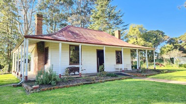
Building - Bushy Park
... ...Wellington Shire...McMillan Angus Old Gippstown West Gippsland Gippsland Gippsland Heritage Park Goldfields Victorian era Moe Historical Village Wellington Shire Avon River Boisedale Briagolong Dargo Murdoch Mackintosh National Trust Andrew Martin and Matt McCraw. ...13 August 1843 First application for the Bushy Park run appeared in the “Port Phillip Gazette”. It was taken up by Angus McMillan, who took up the Boisdale run across the Avon River at the same time, for his employer Lachlan Macalister. This house was built in 1848. March 1844 Licence to Bushy Park granted to McMillan. It consisted of 16,000 acres. Late 1840s Bushy Park homestead built for McMillan by Andrew Martin and Matt McCraw. High local historic significance as associated with major pioneer and a very old white settlement in Gippsland.A square shaped timber house, with a corrugated iron roof over shingles. It has a verandah that covers both the front and sides of the house. The house is contructed of redgum timber, and internally has four rooms.National Trust of Australia Plaque - Bushy Park Homestead - Class 'C'mcmillan, angus, old gippstown, west gippsland, gippsland, gippsland heritage park, goldfields, victorian era, moe, historical village, wellington shire, avon river, boisedale, briagolong, dargo, murdoch mackintosh, national trust, andrew martin and matt mccraw., latrobe valley, old gippstown heritage park, gunaikurnai, latrobe city council -
 Old Gippstown
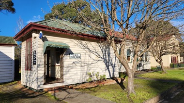
Building - Police Station
... ...Wellington shire...High local historic significance on account of age. police maffra Old Gippstown West Gippsland Gippsland Gippsland Heritage Park Goldfields Coal Mine Victorian era Moe Historical Village Wellington shire Old Gippstown Heritage Park Latrobe Valley Law Latrobe City Council A small timber building, rectangular in shape with a gabled corrugated iron roof. ...One-room police station was built in 1869 in Maffra and moved c.1882 to a new site in Maffra, by the new police residence office. The office was enlarged in 1936, incorporating the old police station.High local historic significance on account of age.A small timber building, rectangular in shape with a gabled corrugated iron roof. There is a small hood over the rear entrance of the station.police, maffra, old gippstown, west gippsland, gippsland, gippsland heritage park, goldfields, coal mine, victorian era, moe, historical village, wellington shire, old gippstown heritage park, latrobe valley, law, latrobe city council -
 Old Gippstown
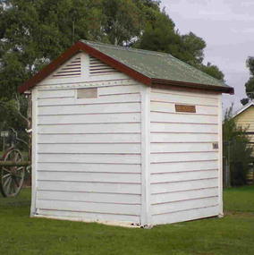
Building - Police Station Lockup
... ...Wellington Shire...Old Gippstown West Gippsland Gippsland Gippsland Heritage Park Goldfields Victorian era Moe Historical Village Wellington Shire Maffra Cell police Old Gippstown Heritage Park Latrobe Valley Lock up Latrobe City Council This cell has many different things written on the inside walls. ...One-room cell-lockup, possibly transferred from Rosedale to Maffra in 1869, moved to Old Gippstown in 1973.High local significance on account of age.A small square shaped timber building with a gabled corrugated iron roof. Built in 1869. The door is not original and has been roughly made of pallet boards.This cell has many different things written on the inside walls.old gippstown, west gippsland, gippsland, gippsland heritage park, goldfields, victorian era, moe, historical village, wellington shire, maffra, cell, police, old gippstown heritage park, latrobe valley, lock up, latrobe city council -
 Emerald Museum & Nobelius Heritage Park
Map - Municipality Road classification - Wellington Rd. (section) 1978, Image of map indicating road classification alterations Wellington Rd. 1978, C1978
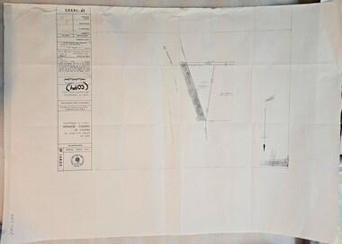
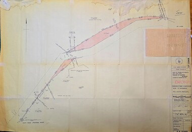
... Map showing alterations to road classification Wellington Rd. Shire of Sherbrooke 1978...Title Survey Division/Crown Description/Part of Croan Allotment 104 Parish of Naree Worran County of Mornington/AMG reference 7922/55/358000/5798500/Municipality Road Classification/Shire of Sherbrooke Wellington Rd./Approved S.R. CLARKE, Principal Surveyor and Proper Officer 13.9.78/SP14820...Emerald Museum & Nobelius Heritage Park 5 Crichton Rd Emerald yarra-valley-and-the-dandenong-ranges Title Survey Division/Crown Description/Part of Croan Allotment 104 Parish of Naree Worran County of Mornington/AMG reference 7922/55/358000/5798500/Municipality Road Classification/Shire of Sherbrooke Wellington Rd./Approved S.R. CLARKE, Principal Surveyor and Proper Officer 13.9.78/SP14820 Map showing alterations to road classification Wellington Rd. ...Map showing alterations to road classification Wellington Rd. Shire of Sherbrooke 1978Title Survey Division/Crown Description/Part of Croan Allotment 104 Parish of Naree Worran County of Mornington/AMG reference 7922/55/358000/5798500/Municipality Road Classification/Shire of Sherbrooke Wellington Rd./Approved S.R. CLARKE, Principal Surveyor and Proper Officer 13.9.78/SP14820 -
Emerald Museum & Nobelius Heritage Park
Map - Municipality Road Classification - Wellington Rd. (part) - Near Kitty Street, Crown Survey map - Crown allotments 106F2 & 106 G1 - Wellington Rd. near Kitty Street, c1972
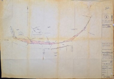
... Image of Title survey - Part of Crown Allotments 106F2 and 106G1 - Wellington Road, Shire of Sherbrooke ...SP12969/Title Survey Division/Crown Description/Part of Crown Alloments 106F2, 106F3 and 106G1, Parish of Narree Worran, County of Mornington/Municipality Road Classification/Shire of Sherbrooke, Wellington Road/(signed) Rossley Paul Gardner of Kirkpatrick & Webber, 280 Maroondah Highway, Ringwood, 29th March 1972/(Signed) S.R. ...CLARKE, Principal Title Survey Officer & Proper Officer 21.6.72 Image of Title survey - Part of Crown Allotments 106F2 and 106G1 - Wellington Road, Shire of Sherbrooke Crown Survey map - Crown allotments 106F2 & 106 G1 - Wellington Rd. near Kitty Street Map Municipality Road Classification - Wellington Rd. ...Image of Title survey - Part of Crown Allotments 106F2 and 106G1 - Wellington Road, Shire of Sherbrooke SP12969/Title Survey Division/Crown Description/Part of Crown Alloments 106F2, 106F3 and 106G1, Parish of Narree Worran, County of Mornington/Municipality Road Classification/Shire of Sherbrooke, Wellington Road/(signed) Rossley Paul Gardner of Kirkpatrick & Webber, 280 Maroondah Highway, Ringwood, 29th March 1972/(Signed) S.R. CLARKE, Principal Title Survey Officer & Proper Officer 21.6.72 -
 Emerald Museum & Nobelius Heritage Park
Map - Surveyors map of Wellington Rd. near Magpie Rd., Clematis, Part of Crown allotments 106E and 106G2, survey map of Wellington Rd., near Magpie Rd. 1972, c1972
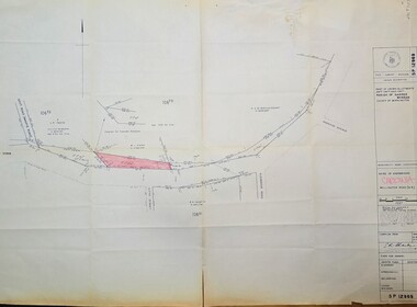
... Title Survey Division/Crown Description/Part of Crown Allotments 106E and 106G2/Parish of Narree Worran, County of Mornington/Cardinia/Shire of Sherbrooke, Wellington Road/Rossley Paul Gardiner of Kirkpatrick & Webber, 289 Maroondah Hwy, Ringwood/Signed S.R. ...Emerald Museum & Nobelius Heritage Park 5 Crichton Rd Emerald yarra-valley-and-the-dandenong-ranges Title Survey Division/Crown Description/Part of Crown Allotments 106E and 106G2/Parish of Narree Worran, County of Mornington/Cardinia/Shire of Sherbrooke, Wellington Road/Rossley Paul Gardiner of Kirkpatrick & Webber, 289 Maroondah Hwy, Ringwood/Signed S.R. ...Image of Surveyors map outlining part of Wellington Rd., Near Magpie Rd., Clematis 1972Title Survey Division/Crown Description/Part of Crown Allotments 106E and 106G2/Parish of Narree Worran, County of Mornington/Cardinia/Shire of Sherbrooke, Wellington Road/Rossley Paul Gardiner of Kirkpatrick & Webber, 289 Maroondah Hwy, Ringwood/Signed S.R. Clarke 21.6.72/B.A. Gibson C/T 8047/414 subtract 0.01 1/2 for Title -
 Emerald Museum & Nobelius Heritage Park
Map - Surveyors map of Wellington Rd. near Magpie Rd., and Paradise Rd., Clematis, Part of Crown allotments 106E and 106G2, survey map of Wellington Rd., near Magpie Rd. and Paradise Rd., Clematis 1972, c1972
... Title Survey Division/Crown Description/Part of Crown Allotments 106F2 and 106G1/Parish of Narree Worran, County of Mornington/Cardinia/Shire of Sherbrooke, Wellington Road/Rossley Paul Gardiner of Kirkpatrick & Webber, 289 Maroondah Hwy, Ringwood/Signed S.R. ...Emerald Museum & Nobelius Heritage Park 5 Crichton Rd Emerald yarra-valley-and-the-dandenong-ranges Title Survey Division/Crown Description/Part of Crown Allotments 106F2 and 106G1/Parish of Narree Worran, County of Mornington/Cardinia/Shire of Sherbrooke, Wellington Road/Rossley Paul Gardiner of Kirkpatrick & Webber, 289 Maroondah Hwy, Ringwood/Signed S.R. ...Image of Surveyors map outlining part of Wellington Rd., Near Magpie Rd. and Paradise Rd., Clematis 1972Title Survey Division/Crown Description/Part of Crown Allotments 106F2 and 106G1/Parish of Narree Worran, County of Mornington/Cardinia/Shire of Sherbrooke, Wellington Road/Rossley Paul Gardiner of Kirkpatrick & Webber, 289 Maroondah Hwy, Ringwood/Signed S.R. Clarke 21.6.72 -
 Emerald Museum & Nobelius Heritage Park
Map - Surveyors map of Wellington Rd. near Magpie Rd., and Paradise Rd., Clematis, Part of Crown allotments 106F2 and 106G1, survey map of Wellington Rd., near Magpie Rd. and Paradise Rd., Clematis 1972, c1972
... Title Survey Division/Crown Description/Part of Crown Allotments 106F2 and 106G1/Parish of Narree Worran, County of Mornington/Cardinia/Shire of Sherbrooke, Wellington Road/Rossley Paul Gardiner of Kirkpatrick & Webber, 289 Maroondah Hwy, Ringwood/Signed S.R. ...Emerald Museum & Nobelius Heritage Park 5 Crichton Rd Emerald yarra-valley-and-the-dandenong-ranges Title Survey Division/Crown Description/Part of Crown Allotments 106F2 and 106G1/Parish of Narree Worran, County of Mornington/Cardinia/Shire of Sherbrooke, Wellington Road/Rossley Paul Gardiner of Kirkpatrick & Webber, 289 Maroondah Hwy, Ringwood/Signed S.R. ...Image of Surveyors map outlining part of Wellington Rd., Near Magpie Rd. and Paradise Rd., Clematis 1972Title Survey Division/Crown Description/Part of Crown Allotments 106F2 and 106G1/Parish of Narree Worran, County of Mornington/Cardinia/Shire of Sherbrooke, Wellington Road/Rossley Paul Gardiner of Kirkpatrick & Webber, 289 Maroondah Hwy, Ringwood/Signed S.R. Clarke 21.6.72 -
 Emerald Museum & Nobelius Heritage Park
Map - Municipality Road Classification - Wellington Rd. (part), Crown Description - part of Crown Allotment 106 G1, Parish of Narree Worran, c1977
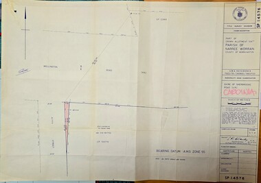
... Image of Title Survey, Part of Crown Allotment 106G1, Road Classification Shire of Sherbrooke Rd (Wellington Rd.)...CLARKE, Principal Surveyor and Proper Officer 21.11.77 Image of Title Survey, Part of Crown Allotment 106G1, Road Classification Shire of Sherbrooke Rd (Wellington Rd.) Crown Description - part of Crown Allotment 106 G1, Parish of Narree Worran Map Municipality Road Classification - Wellington Rd. ...Image of Title Survey, Part of Crown Allotment 106G1, Road Classification Shire of Sherbrooke Rd (Wellington Rd.)SP14576/Title Survey Division/Crown Description/Part of Crown Allotment 106 G1, Parish of Narree Worran, County of Mornington/AMG Reference 7922/55/360800/5800100/Municipality Road Classification/Shire of Sherbrooke Road/Kenneth Douglas Adams, Country Roads Board, 60 Denmark Street, Kew, Surveyor, dated 15th November, 1977/Approved S.R. CLARKE, Principal Surveyor and Proper Officer 21.11.77 -
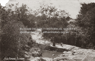 Eltham District Historical Society Inc
Photograph, Old Bridge, Kaylock's Crossing, Brougham Street, Eltham, c.1895
... The presentation included slides of historic photos from the Shire of Eltham Pioneers collections as well as several recent views. Photo of earliest known crossing of the Diamond Creek at brougham Street brougham street eltham wellington street kaylocks bridge bridge diamond creek (creek) Postcard photo print Old Bridge, Kaylock's Crossing, Brougham Street, Eltham Photograph Photograph ...Brougham Street was created in Josiah Holloway's 1851 subdivision of Little Eltham. It was one of several east-west streets shown on the subdivision plan as crossing the Diamond Creek. The western part was named Wellington Street on the subdivision plan but was later changed to conform with the name of the eastern part as acknowledgement of the continuity of the street. It is not known when the first bridge was constructed in Brougham Street however it was certainly mentioned at Council’s meeting of 2 June 1884 as being in a dangerous state of repair. This photo (c.1895) of an old bridge shows a very low-level simple log girder bridge crossing the creek at a right angle and so the approaches involved bends in the road alignment. This bridge was generally known as Kaylocks Bridge or Kaylock’s Crossing after the owner of the adjoining land. It was most likely built from around the mid-1850s, or a crossing of some fashion established as Richard George Kaylock, butcher of Little Eltham and his wife Emily Ann settled there in 1854. His property was in Wellington Street (now Brougham Street) and apparently extended across the Diamond Creek. The land on the western side of the creek was farmed, the house being on the eastern side. Kaylock's Bridge formed part of the original coach road to Eltham and in 1922 was described as an "old rustic bridge". Its low level and insubstantial construction made it susceptible to flood damage, necessitating frequent closures until repairs could be carried out. In September 1922, Council called for tenders for a new timber bridge to be constructed at Kaylock’s crossing. An engineering assessment carried out for the Council by Macleod Consulting at the time of the replacement suggested that the construction details indicate that it was in the 1900s, however this dating could possibly have been the result of numerous repairs undertaken over the years to flood damage. The tender was awarded to Mr Weller of Kangaroo Ground who commenced work in February 1923 on a higher-level timber trestle bridge. Work was slowed due to illness of the contractor and the accidental death of a man in March 1923 following the collapse of the bank after he had jumped into a hole that had just been blasted. The bridge was completed around July 1923 at which point the old structure was pulled up, marking what was described in the ‘Advertiser’ newspaper as the passing of an old and well-loved landmark in the district. In April 1924 the approach to Kaylocks bridge was washed away during the heavy flooding that destroyed the Main Road bridge. The western side was repaired, and an extra span was added to the eastern side using timber from the destroyed Main Road bridge. The bridge was again severely damaged four months later in August 1924 When a lack of finances delayed repairs to the Bridge Street bridge in 1931 (also referred to as Obelisk Bridge at the time), traffic had to detour via Brougham Street for some time. Local residents feared that the Bridge Street bridge might never reopen. Kaylocks Bridge was constantly subject to damage by floods. In the 1934 flood it was submerged by two feet of water. In more recent times the bridge was again severely damaged by flooding and repairs made. A new bridge and adjoining footbridge were constructed in 2009. Part of a slide show presentation "Bridges & Waterways of the Shire" by Russell Yeoman to the 13 September 1989 Society meeting. The presentation included slides of historic photos from the Shire of Eltham Pioneers collections as well as several recent views.Photo of earliest known crossing of the Diamond Creek at brougham StreetPostcard photo printbrougham street, eltham, wellington street, kaylocks bridge, bridge, diamond creek (creek) -
Bendigo Historical Society Inc.
Document - Voters' Roll for the Strathfieldsaye Riding of the Shire of Strathfieldsaye, July 1888
... Strathfieldsaye Shire Council was located 8km south-east of Bendigo. Its name recalled the Duke of Wellington's Hampshire estate; it was also the name of a migrant ship in 1839 and of William Raymond's station in 1842. ...History House 11 Mackenzie Street Bendigo goldfields Strathfieldsaye Shire Council was located 8km south-east of Bendigo. Its name recalled the Duke of Wellington's Hampshire estate; it was also the name of a migrant ship in 1839 and of William Raymond's station in 1842. ...Strathfieldsaye Shire Council was located 8km south-east of Bendigo. Its name recalled the Duke of Wellington's Hampshire estate; it was also the name of a migrant ship in 1839 and of William Raymond's station in 1842. Strathfieldsaye became a district in 1861 and a shire in 1866. The shire hall from the nineteenth century still exists.Voters' Roll for the Strathfieldsaye Riding of the Shire of Strathfieldsaye - Four Page Document. Contains 121 names: Surname; Christian Name; Trade ofr occupation; Description and situation of rateable property; Electoral District and Division; number of votes which voter is entitled.history, bendigo, abbott collection, strathfieldsaye, strathfieldsaye riding, shire of strathfieldsaye -
Glenelg Shire Council Cultural Collection
Negative - Negative - Portland Museum, Victoria, c. 1934
... Glenelg Shire Council Cultural Collection History House Cliff Street Portland great-ocean-road negative Portland Gordon Hotel building construction museum NEGATIVE FOR BLACK AND WHITE PHOTOGRAPH Portland museum east side of Wellington Rd. ...NEGATIVE FOR BLACK AND WHITE PHOTOGRAPH Portland museum east side of Wellington Rd. Wooden building, iron roof, whale bones on verandah and in garden. Woman standing on veranda. Building one of original buildings of hotel where current Gordon Hotel is.negative, portland, gordon hotel, building, construction, museum -
Glenelg Shire Council Cultural Collection
Photograph - Sheet of 12 contact prints - Various Portland and local surrounds buildings and landmarks, c. 1970
... Glenelg Shire Council Cultural Collection History House Cliff Street Portland great-ocean-road Sheet of 12 contact prints of rephotographed photographs: Identifying numbers 5721 a, b, c, d, e, f, g, h, i, j, k, l (a) Fishing party, flat rocks Bridgewater (b) Dutton Way (c) Julia Street (d) Steam train (e) Bentinck Street corner (f) Bridge across Salt Creek 'Kingsley' in background (g) Bentinck Street railway station from Customs House (h) Yankee Doodle corner (i) Picnic on banks of river (j) Henty Bay (k) Man holding two bikes Wellington Road/Bentinck Street (l) same as (h) - Bentinck Street railway station from Customs House Photograph Sheet of 12 contact prints - Various Portland and local surrounds buildings and landmarks ...Sheet of 12 contact prints of rephotographed photographs: Identifying numbers 5721 a, b, c, d, e, f, g, h, i, j, k, l (a) Fishing party, flat rocks Bridgewater (b) Dutton Way (c) Julia Street (d) Steam train (e) Bentinck Street corner (f) Bridge across Salt Creek 'Kingsley' in background (g) Bentinck Street railway station from Customs House (h) Yankee Doodle corner (i) Picnic on banks of river (j) Henty Bay (k) Man holding two bikes Wellington Road/Bentinck Street (l) same as (h) - Bentinck Street railway station from Customs House -
Glenelg Shire Council Cultural Collection
Photograph - Photograph - bulk storage, n.d
... Glenelg Shire Council Cultural Collection History House Cliff Street Portland great-ocean-road Port of Portland Authority Archives Front: 6970 pencil Photo for 'Oil in Australia and Portland' Article 40cms wide F 120 Blue biro Back: Portland guardian stamps Black and white photograph of bulk storage containers, Wellington Road. ...Port of Portland Authority ArchivesFront: 6970 pencil Photo for 'Oil in Australia and Portland' Article 40cms wide F 120 Blue biro Back: Portland guardian stamps -
Glenelg Shire Council Cultural Collection
Photograph - Photograph - oil tanks, n.d
... Glenelg Shire Council Cultural Collection History House Cliff Street Portland great-ocean-road Port of Portland Authority Archives Port of Portland Archives oil tanks Back: 2398 Lines drawn in biro 5 3/4" 4 1/8" 8036 s/s in pencil Black and white photograph showing shell oil tanks, west side of Wellington Rd. ...Port of Portland Authority ArchivesBack: 2398 Lines drawn in biro 5 3/4" 4 1/8" 8036 s/s in pencilport of portland archives, oil tanks -
Glenelg Shire Council Cultural Collection
Photograph - Photograph - oil tanks, n.d
... Glenelg Shire Council Cultural Collection History House Cliff Street Portland great-ocean-road Port of Portland Authority Archives Port of Portland Archives Fishermans Breakwater Black and white photograph showing shell oil tanks west side of Wellington Road. ...Port of Portland Authority Archivesport of portland archives, fishermans breakwater -
Glenelg Shire Council Cultural Collection
Photograph - Photograph - bulk storage, n.d
... Glenelg Shire Council Cultural Collection History House Cliff Street Portland great-ocean-road Port of Portland Authority Archives Port of Portland Archives bulk storage Black and white photograph of bulk storage containers, Wellington Road. ...Port of Portland Authority Archivesport of portland archives, bulk storage -
Glenelg Shire Council Cultural Collection
Photograph - Photograph - construction site, n.d
... Glenelg Shire Council Cultural Collection History House Cliff Street Portland great-ocean-road Port of Portland Authority Archives Port of Portland Archives oil tanks Kingsley Wellington Road Portland Black and white photograph showing site levelled for construction of bulk oil tanks. ...Port of Portland Authority Archivesport of portland archives, oil tanks, kingsley, wellington road, portland -
Glenelg Shire Council Cultural Collection
Photograph - Photograph - oil tanks, n.d
... Glenelg Shire Council Cultural Collection History House Cliff Street Portland great-ocean-road Port of Portland Authority Archives Port of Portland Archives Shell Oil Portland Fishermans Breakwater Satcol Back: 2398 Lines drawn in biro 5 3/4" 4 1/8" 8036 s/s in pencil Black and white photograph showing shell oil tanks, west side of Wellington Road. ...Port of Portland Authority ArchivesBack: 2398 Lines drawn in biro 5 3/4" 4 1/8" 8036 s/s in pencilport of portland archives, shell oil, portland, fishermans breakwater, satcol -
Glenelg Shire Council Cultural Collection
Photograph - Photograph - Oil tanks, n.d
... Glenelg Shire Council Cultural Collection History House Cliff Street Portland great-ocean-road Port of Portland Authority Archives Port of Portland Black and white photograph of shell oil tanks, west side of Wellington Road taken from port area. ...Port of Portland Authority Archivesport of portland -
Glenelg Shire Council Cultural Collection
Photograph - Photograph - Oil tanks, n.d
... Glenelg Shire Council Cultural Collection History House Cliff Street Portland great-ocean-road Port of Portland Authority Archives Port of Portland Back: M, D '80 in pencil Black and white photograph of shell oil tanks, west side of Wellington Road taken from port area. ...Port of Portland Authority ArchivesBack: M, D '80 in pencilport of portland -
Glenelg Shire Council Cultural Collection
Photograph, Photograph - Construction site, n.d
... Glenelg Shire Council Cultural Collection History House Cliff Street Portland great-ocean-road Port of Portland Authority Archives Port of Portland Black and white photograph showing site levelled for construction of bulk oil tanks. Houses on east side of Wellington ...Port of Portland Authority Archivesport of portland -
Glenelg Shire Council Cultural Collection
Photograph, Oil tanks, n.d
... Glenelg Shire Council Cultural Collection History House Cliff Street Portland great-ocean-road Port of Portland Authority Archives Black and white photograph of shell oil tanks, west side of Wellington Road taken from port area. ...Port of Portland Authority Archives -
 Glenelg Shire Council Cultural Collection
Photograph - Photograph - Portland, n.d
... Glenelg Shire Council Cultural Collection History House Cliff Street Portland great-ocean-road Con Kroker Collection Black & White photo taken from the bottom of Wellington Rd. looking across the harbour. ...Con Kroker Collection -
Glenelg Shire Council Cultural Collection
Photograph - Photograph - Main Breakwater construction, Portland, n.d
... Glenelg Shire Council Cultural Collection History House Cliff Street Portland great-ocean-road Port of Portland Authority Archives Port of Portland Archives main breakwater construction Battery Point Portland Harbour Black and white photo looking from Wellington Road at the base of Battery Point to the main Breakwater. ...Port of Portland Authority Archivesport of portland archives, main breakwater, construction, battery point, portland harbour -
Glenelg Shire Council Cultural Collection
Photograph - Photograph - Railway Construction, Port of Portland, n.d
... Glenelg Shire Council Cultural Collection History House Cliff Street Portland great-ocean-road Port of Portland Authority Archives Port of Portland Archives Portland Harbour Trust Portland Lifeboat botanical gardens Black and white photo. Portland Harbour Trust railway line in foreground. Wellington ...Port of Portland Authority Archivesport of portland archives, portland harbour trust, portland lifeboat, botanical gardens -
Glenelg Shire Council Cultural Collection
Photograph - Reproduction Photograph - Wando Villa / Stanton Drew, 89 Wellington Road, Portland Victoria, n.d
... Glenelg Shire Council Cultural Collection History House Cliff Street Portland great-ocean-road Contemporary reproduction of a period photo of Wando Villa / Stanton drew. Front view, group of children and adults sitting/standing at front of house Photograph Reproduction Photograph - Wando Villa / Stanton Drew, 89 Wellington Road, Portland Victoria ...Contemporary reproduction of a period photo of Wando Villa / Stanton drew. Front view, group of children and adults sitting/standing at front of house -
Glenelg Shire Council Cultural Collection
Document - Antique Auction - 'Stanton Drew' Property Portland 1976, Stanton Drew, Portland, Victoria, Mar-76
... Glenelg Shire Council Cultural Collection History House Cliff Street Portland great-ocean-road Stanton Drew 23 page catalogue, produced by Leonard Joel Auctioneers and Valuers for the auction of antique furniture, Victoriana, china, silver, bric-a-brac etc. on the property 'Stanton Drew', 89 Wellington Road, Portland, Victoria, on Monday 15th March 1976. ...23 page catalogue, produced by Leonard Joel Auctioneers and Valuers for the auction of antique furniture, Victoriana, china, silver, bric-a-brac etc. on the property 'Stanton Drew', 89 Wellington Road, Portland, Victoria, on Monday 15th March 1976. Glossy paper cover, burgundy and white photo of 'Stanton Drew' across front and back. Inside shiny white paper, burgundy print.stanton drew