Showing 128 items matching "aerial survey map"
-
 Bendigo Military Museum
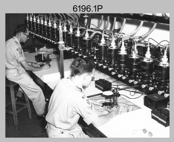
Photograph - Multiplex mechanical stereoplotting equipment, Army Survey Regiment, Fortuna Bendigo, c1950s
This is a set of five photographs of Multiplex mechanical stereoplotting equipment at the Army Survey Regiment, Fortuna Bendigo. c1950s. Multiplex equipment was imported from the UK in 1951 and introduced in the following year, to accelerate map production output covering CMF training areas at 1:25,000 map scale. Multiplex plotting was a productive advancement replacing the ‘Arundel’ method of graphical plotting planimetric detail that was expensive and slow, especially in timbered mountainous terrain. Air photos were made into small diapositives and mounted on racks in the exact position relative to when the aerial photos were taken. The technicians operated the Multiplex in a darkened room, with one photo projected with a green filter and the other through a red filter to form a 3D view of the overlapping photos. The 3D model projected onto a platen, which was a small platform that was raised up and down. The technician viewed the 3D image with special glasses fitted with red and green lenses. In the centre of the platen was a small pinhole that served as a floating mark, with a vertical pencil located exactly below the pinhole. This tracing table was moved to follow the topographic feature or contour line and draw it on the paper underneath. The technician raising or lowering the platform’s floating mark to match the height of the 3D terrain. It also replaced the slotted template method of mechanical adjustment of strips of aerial photography, however was restricted to each strip rather than between strips in the block. Although the Multiplex was phased out of production in 1968, it was used in the training of photogrammetry and aero-triangulation at the School of Military Survey located at Bonegilla, Victoria until the early 1990s. The history of the Multiplex is covered in more detail with additional historic photographs, in pages 50 to 51 of Valerie Lovejoy’s book 'Mapmakers of Fortuna – A history of the Army Survey Regiment’ ISBN: 0-646-42120-4.This is a set of five photographs of Multiplex mechanical stereoplotting equipment at the Army Survey Regiment, Fortuna, Bendigo. c1950s. The photographs were printed on photographic paper and are part of the Army Survey Regiment’s Collection. The photographs were scanned at 300 dpi. .1) - Photo, black & white, c1950s, unidentified personnel operating Multiplex equipment. .2) - Photo, black & white, c1950s, Multiplex equipment. .3) - Photo, black & white, c1950s, Multiplex components identified. .4) - Photo, black & white, c1950s, Multiplex optical components. .5) - Photo, black & white, c1950s. Unidentified technician laying down individual Multiplex plots..1P to .2P, .4P – No annotations. .3P annotations identifying Multiplex components on front of photo. .5P annotated on front ‘Lay down of individual Multiplex plots at 1/14000 to framework of master grid to form Composite Compilation Sheet – Material Duralex.’royal australian survey corps, rasvy, army survey regiment, army svy regt, fortuna, asr, photogrammetry -
 Bendigo Military Museum
Photograph - Retouching Reproduction Material at the Army Survey Regiment, c1960s, c1970s
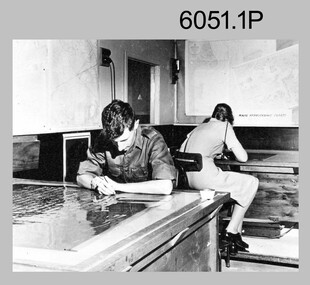
The first four photographs were most likely taken in the 1960 and the fifth in the 1970s at the Army Survey Regiment, Fortuna, Bendigo. As there are no annotations with the photos, the exact dates, locations and names of personnel are unknown. SGT Bob Scaddan appears in the fifth photo taken in the 1970s Photos .1P and .2P. could have been taken in Lithographic Squadron’s retouching room and Photos .3P, .4P and .5P. were probably taken in Cartographic Squadron’s Correcting Section, located in the Attic. Retouching mainly entailed the application of liquid opaque (Plumtree), commonly known as “duff” to cover blemishes such as scratches and spots on film negatives before photographic exposure. Retouching technicians also used specialised techniques such as “needling” to repair faults on the emulsion of map reproduction material. The technician in photo .4P is needling a hydrographic feature on a drainage negative, with a zoom transfer scope projecting a scaled projected aerial photograph as a positional reference. This is a set of five photographs of technicians retouching reproduction material at the Army Survey Regiment, Bendigo. The photographs were printed on photographic paper and are part of the Army Survey Regiment’s Collection. The photographs were scanned at 300 dpi. .1) - Photo, black & white, c1960s. unidentified personnel in Lithographic Squadron. .2) - Photo, black & white, c1960s. unidentified personnel in Lithographic Squadron. .3) - Photo, black & white, c1960s. unidentified personnel in Cartographic Squadron Attic. .4) - Photo, black & white, c1960s. unidentified personnel in Cartographic Squadron Attic. .5) - Photo, black & white, c1970s. SGT Bob Scaddan in Cartographic Squadron..1P to .3P, .5P - annotated “Retouching”royal australian survey corps, rasvy, army survey regiment, army svy regt, fortuna, asr, litho, carto -
 Bendigo Military Museum
Photograph - Photographic Technicians performing tasks at the Army Survey Regiment, c1970s
These eleven photographs were most likely taken in the 1970s in Lithographic Squadron at the Army Survey Regiment, Fortuna, Bendigo. Although Photo .1P is not annotated the remainder have the technician’s name written on the back. The equipment operated by the technicians is not identified. The dates are unknown but most of these photos were probably taken the late 1970s. The main tasks undertaken by the technicians were most likely enlargements, reductions and duplication of map reproduction material, and aerial photography.This is a set of photographs of technicians operating photographic reproduction equipment at the Army Survey Regiment, Bendigo c1970s. The photographs were printed on photographic paper and are part of the Army Survey Regiment’s Collection. The photographs were scanned at 300 dpi. .1) - Photo, black & white, c1970s, unidentified, Lithographic Squadron .2) - Photo, black & white, c1970s, Gary Drummond, Lithographic Squadron .3) - Photo, black & white, c1970s, John Scott, Lithographic Squadron .4) - Photo, black & white, c1970s, WILD U4A Diapositive Camera, Bob Chamberlain, Lithographic Squadron. 5) - Photo, black & white, c1970s, WILD U4A Diapositive Camera, Zoe (Lisiewich) Ames, Lithographic Squadron .6) - Photo, black & white, c1970s, Garry Hudson, Lithographic Squadron .7) - Photo, black & white, c1970s, Garry Hudson, Lithographic Squadron .8) - Photo, black & white, c1970s, Garry Hudson, Lithographic Squadron .9) - Photo, black & white, c1970s, Mick Ellis, Lithographic Squadron .10) - Photo, black & white, c1970s, Col Darch, Lithographic Squadron .11) - Photo, black & white, c1970s, Phil Beatty, Lithographic Squadron.1P – no annotation .2 to .11 – personnel names (less rank) annotated on back. royal australian survey corps, rasvy, army survey regiment, army svy regt, fortuna, asr, litho -
 Bendigo Military Museum
Photograph - Photo Troop, Lithographic Squadron – Army Survey Regiment, Fortuna, Bendigo, 1988
This collection of 10 photos was most likely taken at Lithographic Squadron, Army Survey Regiment, Fortuna, Bendigo in 1988. The main tasks undertaken by technicians in Photo Troop were most likely enlargements, reductions and duplication of map reproduction material, and processing of aerial photography.This is a set of 10 photographs of Photo Troop personnel and equipment from Lithographic Squadron at the Army Survey Regiment, Fortuna, Bendigo, 1988. The photographs were on 35mm negative film and were scanned at 96 dpi. They are part of the Army Survey Regiment’s Collection. .1) - Photo, black & white, 1988, BARCRO work area, SPR Gary Sievers. .2) - Photo, black & white, 1988, KLIMSCH Commodore camera, CPL Mick Gillham. .3) - Photo, black & white, 1988, KLIMSCH Commodore camera, CPL Mick Gillham. .4) - Photo, black & white, 1988, WILD U4A Diapositive Camera, SPR Rob Jones. .5) - Photo, black & white, 1988, WILD U4A Diapositive Camera, SPR Rob Jones. .6) - Photo, black & white, 1988, WILD U4A Diapositive Camera, SPR Rob Jones. .7) - Photo, black & white, 1988, WILD U4A Diapositive Camera, SPR Rob Jones. .8) - Photo, black & white, 1988, WILD U4A Diapositive Camera, SPR Rob Jones. .9) - Photo, black & white, 1988, Photographic camera enlarger, unidentified technician. .10) - Photo, black & white, 1988, SUPER CHROMEGA F Photographic camera enlarger. No personnel are identifiedroyal australian survey corps, rasvy, army survey regiment, army svy regt, fortuna, asr, litho -
 Bendigo Military Museum
Photograph - Orthophotomap Workstation, Lithographic Squadron – Army Survey Regiment, Fortuna, Bendigo, 1988
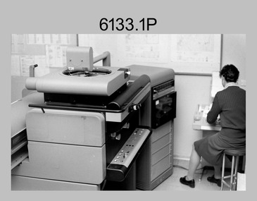
This collection of four photos was most likely taken at Lithographic Squadron, Army Survey Regiment, Fortuna, Bendigo in 1988. Orthophoto mapping provided the Survey Corps with the capability to produce map products quickly in the event of a crisis. These are four photographs of equipment used by the Army Survey Regiment to produce orthophotomaps. The OR1 orthophoto projector and workstation was introduced in the mid-1980s. It was the second-generation equipment used to orthorectify colour and monochrome film aerial photography, replacing the system introduced in 1973. Orthorectification is the process of removing geometric distortions and scale errors/variations from images. Images have tilt and relief distortions that make it difficult to compare accurately a map and an image of the same geographic area. Once an image is orthorectified, features on the image are shown in their planimetric locations. These four photographs of orthorectification equipment in operation were taken at the Army Survey Regiment at Fortuna, Bendigo, 1988. The photographs were on 35mm negative film and were scanned at 96 dpi. They are part of the Army Survey Regiment’s Collection. .1) to .4) - Photo, black & white, 1988, WILD OR-1 Orthorectification Workstation, SPR Carmel (Butler) Fauth.No personnel are identifiedroyal australian survey corps, rasvy, army survey regiment, army svy regt, fortuna, asr, litho -
 Bendigo Military Museum
Pamphlet - An Introduction to Topographic Mapping, C 1991
... map production: Establish Survey Control, Aerial Photography... map production: Establish Survey Control, Aerial Photography ...This pamphlet was published by the Army Survey Regiment as an overview of the Royal Australian Survey Corps (RASvy), its role and unit structure circa 1991, prior to RASvy’s disbandment in 1996. The pamphlet comprehensively detailed the eight steps of topographic map production: Establish Survey Control, Aerial Photography, Aerotriangulation, Stereoplotting, Field Verification, Cartography, Printing and Storage/Map Distribution. Leading technologies used by RA Svy in 1991 included GPS control surveys, 5 colour printing on the Speedmaster offset press and bulk map packaging using the Map Handling Station (with guillotine). Digital map production was operating on the AUTOMAP 2 system, before the “Newheart” system upgrade two years later. Printed on the pamphlet cover was a portion of the plane tabled “four inches to a mile” map of Newcastle. This was compiled and surveyed in 1910 by LCPL A. Barrett, a member of the RAE Detachment, as part of the first major topographic mapping effort of Australia.This is a Royal Australian Survey Corp pamphlet with a historical map printed in colour on cardboard on both sides of the cover. There are 16 pages printed in colour on gloss paper, with photos, diagrams and descriptions. The pamphlet is bounded by two staples on its spine. Each of the 17 images were scanned at 300 dpi in JPEG (.jpg) format and stored on the attached 16 Gb USB memory stick. The images have been converted into MPEG-4 (.mp4) video format, 4Mb in size and runs for 2:16 minutes and is also stored on the memory stick.royal australian survey corps, rasvy, fortuna, army survey regiment, army svy regt, asr -
 Bendigo Military Museum
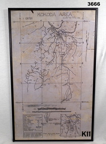
Map - MAP, KOKODA MOUNTED, 2nd Aust Field Survey Section, 4.9.1942
Map was compiled from aerial photos without ground control or inspection & with information received from Major CAMERON.Laminated map of Kokoda area on board backing with black border. Black printing on cream / fawn background. White hanging strap on back. Information ledger bottom LHS. Kokoda inset bottom RHS.Printed at top: “KOKODA AREA” Printed at bottom “RHS: K11”map, kokoda, mounted -
 Federation University Historical Collection
Book, Mining Engineers Handbook Volume 1 & 2, 1941
The book was used by Charles Bacon who studied at the University of Nevada in the late 1930s/early 1940s. Bacon worked at Bunker Hill Mines and Kellogg Idaho, before arriving in Australian in 1951. He worked for CN Myers, a company involved with paper converting. CN Myers was a family business (on Charles Bacon's maternal line). Robert Peele was Professor Emeritus of mining Engineering at the School of Mines, Columbia University.Maroon hardcovered books. .1) Volume 1 - Chapters include Mineralogy, Geology and Mineral Deposits, Earth Excavation, Explosives, Rock Excavation, Tunneling, Shaft Sinking in Rock, Shaft sinking in Unstable and Waterbearing Ground, Boring, Underground Transport, Mine Ventilation. .2) Volume 2 - Chapers include Compressed Air Practice, Electric Power for mine Service, Surveying,Underground Surveying, Mine Geologic Maps and models, Cost of mining, Mining Laws, Ore sampling, Assaying, Aerial Tramways and Cableways, Gold Amalgamation and Cyanidation, etc.Inside front cover "Charles Bacon"charles bacon, mining engineering, mining, engineering, university of nevada, mackay school of mines, explosives, timbering -
 Federation University Historical Collection
Book, Bedford McNeill, Mining and General Telegraphic Code, 1899, 1899
McNeill's Code was arranged to meet the requirements of mining, metallurgical and civil engineers, Directors of Mining, Smelting companies; bankers; stock and share brokers, solicitors, accountants, financiers and general merchants. Bedford McNeil )Assoc. M. Inst. C.E.) was an Associate of the Royal School of Mines; Member of the Institution of Mining and metallurgy and of the north of England Institute of Mining and Mechanical Engineers; and a Fellow of the Geological Society. "OBITUARY - Mr. Bedford McNeill IT is with regret that we announce the death on September 18, due to cerebral hemorrhage, of Mr. Bedford McNeill, the well-known mining engineer, at fifty-five years of age. Apart from his high reputation as a mining engineer, Mr. McNeill’s name was almost a household word in connection with the telegraphic code compiled by him, which was issued originally in 1893, and in an enlarged and revised form in 1908. This code is employed almost without exception by mining-companies and engineers, to whose use it was specially dedicated, and other business men have found it extremely practical for cable communications. [Nature 98, 94-94 (05 October 1916)] Black hard covered book of 807 pages by Bedford McNeil. Contents include: General suggestions for using code; Morse signals, alphabet and figures; Timetable west of Greenwich; Timetable east of Greenwich; map; Alphabetical Code; Survey of Mineral Properties; Numbers; English Money; American money; Lineal measurement; Weights; Letters; Cables; banks; Finance Companies; Substitutions; Extra Code. The book includes the following advertisements: Nobel's Explosives Company; Otto Aerial Ropeways; Tabloid Medicine cases & Chests; Charleton's Report Book for Mining Engineers; Bornhardt's Electrical Firing Machine; On a page towards the front "R. Brook"morse code, mcneill, bedford mcneill, mining, noble's explosives company, otto, charleton, tabloid, bornhadt, brook, r. brook, telegraphy, morse -
 Ringwood and District Historical Society
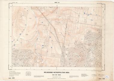
Map - Melbourne Metropolitan Area Base Map Series, Sheet 215 - Ringwood area, 1967
Map prepared by Dept of Lands and Survey and MMBW from State Aerial Survey June 1957 and Cadastral Survey information July 1967. This sheet comprises parts of Municipalities of Doncaster & Templestowe, Nunawading and Ringwood, and Parishes of Nunawading and Warrandyte.Scale: 400 feet to 1 inch. Contours at 5 feet vertical interval. By Authority: A.C. Brooks, Commonwealth Printer, Melbourne. -
 Ringwood and District Historical Society
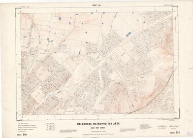
Map - Melbourne Metropolitan Area Base Map Series, Sheet 216 - Ringwood area, 1967
Map prepared by Dept of Lands and Survey and MMBW from State Aerial Survey June 1957 and Cadastral Survey information July 1967. This sheet comprises parts of Municipalities of Croydon, Doncaster & Templestowe, and Ringwood, and Parishes of Ringwood and Warrandyte.Scale: 400 feet to 1 inch. Contours at 5 feet vertical interval. By Authority: A.C. Brooks, Commonwealth Printer, Melbourne. -
 Ringwood and District Historical Society
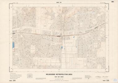
Map - Melbourne Metropolitan Area Base Map Series, Sheet 235 - Ringwood area, 1960
Map prepared by Dept of Lands and Survey and MMBW from State Aerial Survey June 1957 and Cadastral Survey information August 1960. This sheet comprises parts of Municipalities of Doncaster & Templestowe, Nunawading and Ringwood, and Parishes of Nunawading, Ringwood and Warrandyte.Scale: 400 feet to 1 inch. Contours at 5 feet vertical interval. By Authority: A.C. Brooks, Commonwealth Printer, Melbourne. -
 Ringwood and District Historical Society
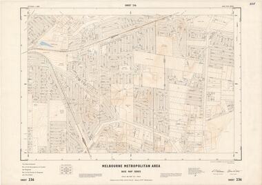
Map - Melbourne Metropolitan Area Base Map Series, Sheet 236 - Ringwood area, 1961
Map prepared by Dept of Lands and Survey and MMBW from State Aerial Survey June 1957 and Cadastral Survey information May 1961. This sheet comprises parts of the Municipalities of Croydon and Ringwood, and Parishes of Ringwood and Warrandyte.Scale: 400 feet to 1 inch. Contours at 5 feet vertical interval. By Authority: A.C. Brooks, Commonwealth Printer, Melbourne. -
 Ringwood and District Historical Society
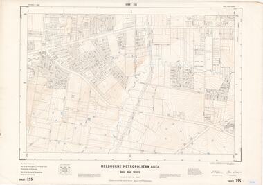
Map - Melbourne Metropolitan Area Base Map Series, Sheet 255 - Ringwood area, 1963
Map prepared by Dept of Lands and Survey and MMBW from State Aerial Survey December 1956 and Cadastral Survey information May 1963. This sheet comprises parts of the Municipalities of Ferntree Gully, Nunawading and Ringwood, and Parishes of Nunawading, Ringwood and Scoresby.Scale: 400 feet to 1 inch. Contours at 5 feet vertical interval. By Authority: A.C. Brooks, Commonwealth Printer, Melbourne. -
 Ringwood and District Historical Society
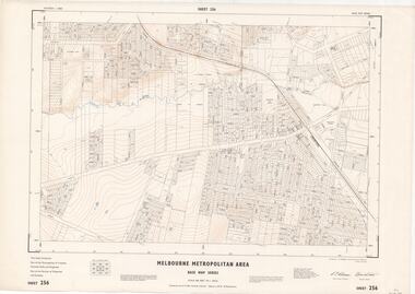
Map - Melbourne Metropolitan Area Base Map Series, Sheet 256 - Ringwood area, 1962
Map prepared by Dept of Lands and Survey and MMBW from State Aerial Survey December 1956 and Cadastral Survey information December 1962. This sheet comprises parts of the Municipalities of Croydon, Ferntree Gully, and Ringwood, and Parishes of Ringwood and Scoresby.Scale: 400 feet to 1 inch. Contours at 5 feet vertical interval. By Authority: A.C. Brooks, Commonwealth Printer, Melbourne. -
 Ringwood and District Historical Society
Map - State Aerial Survey, Dandenong Ranges Area, Parishes of Warrandyte and Ringwood - 1956
... , Parishes of Warrandyte and Ringwood - 1956. Map State Aerial Survey ...Map of central and southern areas of Ringwood and part of Ringwood East and Heathmont compiled by Dept of Lands and Survey, July 1956, from aerial photographs and Cadastral Survey information. Subsequent hand-drawn addition of streets showing layout of "Township of Ballyduffy Estate 1858-60", an earlier proposed subdivision that did not eventuate. (See attached 5009b Ballyshanassy_ Melbourne’s lost suburb.pdf for Ballyduffy historical naming relevance). Ballyduffy Estate streets include City Road, West Prussia Road, Duffy Street, Ireland Street, Evans Street, Victoria Street, Regina Street, Short Road, Prussia Road, Duffy Street East, Ireland Street East, Evans Street East, Chapman Street. Misc Topo 93 Sheet 22, Ringwood A4B2. Scale: 4 chains to 1 inch. Contour interval 20 feet. -
 Ringwood and District Historical Society
Map - State Aerial Survey, Dandenong Ranges Area, Parts of Parishes of Nunawading, Warrandyte and Ringwood - 1956
... , Warrandyte and Ringwood - 1956. Map State Aerial Survey ...Map of Ringwood North and parts of Mitcham, Donvale, Park Orchards and Ringwood East compiled by Dept of Lands and Survey, July 1956, from aerial photographs and Cadastral Survey information. Sheet 1, Ringwood A2D or 849 A2D Zone 7. Scale: 4 chains to 1 inch. Contour interval 20 feet. -
 Ringwood and District Historical Society
Map - State Aerial Survey, Dandenong Ranges Area Sheet 7, Parishes of Warrandyte, Scoresby, Ringwood and Nunawading - 1956
... and Nunawading - 1956. Map State Aerial Survey ...Map of central and southern areas of Ringwood and part of Ringwood East and Heathmont compiled by Dept of Lands and Survey, July 1956, from aerial photographs and Cadastral Survey information. Subsequent coloured hand-drawn additions showing layout of a number of post-NSW Separation era proposed subdivisions that did not eventuate, including Village of Studley Estate, Township of East Kew Estate, Township of Ballyduffy Estate, Township of New Flemington Estate, Township of East Hawthorne Estate. Ringwood A4B2, 849 A4B Zone 7. Scale: 10 chains to 1 inch. Contour interval 20 feet. -
 St Kilda Historical Society
Photograph - Photo map, 28/01/1951
One of a series of photo-maps produced for the Department of Crown Lands and Survey (1857-1983). For correlation with a current map, and access to other historical photo maps of Victoria, see the Historic Photo-Maps Index published by the Department of Environment, Land, Water and Planning at https://services.land.vic.gov.au/DELWPmaps/historical-photomaps/Black and white aerial photograph1424-45 SECRET 534 Run 18 Lens 12" Melbourne Metropolitan 12150 28.1.51 M639albert park, st kilda junction, st kilda pier, catani gardens, st kilda, prahran, albert park lake, 1951, middle park, st kilda beach, windsor -
 St Kilda Historical Society
Photograph - Photo map, 17/01/1951
One of a series of photo-maps produced for the Department of Crown Lands and Survey (1857-1983). For correlation with a current map, and access to other historical photo maps of Victoria, see the Historic Photo-Maps Index published by the Department of Environment, Land, Water and Planning at https://services.land.vic.gov.au/DELWPmaps/historical-photomaps/Black and white aerial photograph1414-21 538 Run 19 Lens 12" Melbourne Metropolitan 12150 17.1.51 M586st kilda, st kilda botanical gardens, peanut farm, elwood, 1951, point ormond, elwood canal, st kilda beach -
 St Kilda Historical Society
Photograph - Photo map, 28/01/1951
One of a series of photo-maps produced for the Department of Crown Lands and Survey (1857-1983). For correlation with a current map, and access to other historical photo maps of Victoria, see the Historic Photo-Maps Index published by the Department of Environment, Land, Water and Planning at https://services.land.vic.gov.au/DELWPmaps/historical-photomaps/Black and white aerial photograph1424-118 534 Run 20 Lens 12" Melbourne Metropolitan 12150 18.1.51M639elwood, point ormond, elwood park, elsternwick park, elwood beach, 1951 -
 St Kilda Historical Society
Photograph - Photo map, 17/01/1951
One of a series of photo-maps produced for the Department of Crown Lands and Survey (1857-1983). For correlation with a current map, and access to other historical photo maps of Victoria, see the Historic Photo-Maps Index published by the Department of Environment, Land, Water and Planning at https://services.land.vic.gov.au/DELWPmaps/historical-photomaps/Black and white aerial photograph1414-20 538 Run 19 Lens 12" Melbourne Metropolitan 12150 17.1.51 M586elwood, elsternwick, st kilda east, balaclava, ripponlea, 1951 -
 St Kilda Historical Society
Photograph - Photo map, 28/01/1951
One of a series of photo-maps produced for the Department of Crown Lands and Survey (1857-1983). For correlation with a current map, and access to other historical photo maps of Victoria, see the Historic Photo-Maps Index published by the Department of Environment, Land, Water and Planning at https://services.land.vic.gov.au/DELWPmaps/historical-photomaps/Black and white aerial photograph1424-44 534 Run 18 Lens 12" Melbourne Metropolitan 12150 28.1.51 M639 -
 St Kilda Historical Society
Photograph - Photo map, 28/01/1951
One of a series of photo-maps produced for the Department of Crown Lands and Survey (1857-1983). For correlation with a current map, and access to other historical photo maps of Victoria, see the Historic Photo-Maps Index published by the Department of Environment, Land, Water and Planning at https://services.land.vic.gov.au/DELWPmaps/historical-photomaps/Black and white aerial photograph1424-43 534 Run 18 Lens 12" Melbourne Metropolitan 12150 28.1.51 M639armadale, malvern, st kilda cemetery, caulfield north, st kilda east, 1951 -
 St Kilda Historical Society
Photograph - Photo map, 30/01/1960
One of a series of photo-maps produced for the Department of Crown Lands and Survey (1857-1983). For correlation with a current map, and access to other historical photo maps of Victoria, see the Historic Photo-Maps Index published by the Department of Environment, Land, Water and Planning at https://services.land.vic.gov.au/DELWPmaps/historical-photomaps/Black and white aerial photographVic 1093-62 Melbourne & Metropolitan Project Run 21 30.1.60 Lens 10" 8.200middle park, albert park, catani gardens, st kilda west, 1960 -
 St Kilda Historical Society
Photograph - Photo map, 30/01/1960
One of a series of photo-maps produced for the Department of Crown Lands and Survey (1857-1983). For correlation with a current map, and access to other historical photo maps of Victoria, see the Historic Photo-Maps Index published by the Department of Environment, Land, Water and Planning at https://services.land.vic.gov.au/DELWPmaps/historical-photomaps/Black and white aerial photographVic 1093-60 Melbourne & Metropolitan Project Run 21 30.1.60 Lens 10" 8.200st kilda, albert park, prahran, windsor, south yarra, 1960 -
 St Kilda Historical Society
Photograph - Photo map, 30/01/1960
One of a series of photo-maps produced for the Department of Crown Lands and Survey (1857-1983). For correlation with a current map, and access to other historical photo maps of Victoria, see the Historic Photo-Maps Index published by the Department of Environment, Land, Water and Planning at https://services.land.vic.gov.au/DELWPmaps/historical-photomaps/Black and white aerial photographVic 1092-36 Melbourne & Metropolitan Project Run 22 30.1.60 Lens 10" 8.200st kilda, st kilda pier, st kilda beach, catani gardens, 1960 -
 St Kilda Historical Society
Photograph - Photo map, 30/01/1960
One of a series of photo-maps produced for the Department of Crown Lands and Survey (1857-1983). For correlation with a current map, and access to other historical photo maps of Victoria, see the Historic Photo-Maps Index published by the Department of Environment, Land, Water and Planning at https://services.land.vic.gov.au/DELWPmaps/historical-photomaps/Black and white aerial photographVic 1092-38 Melbourne & Metropolitan Project Run 22 30.1.60 Lens 10" 8.200st kilda, st kilda beach, st kilda pier, catani gardens, 1960, st kilda botanical gardens, peanut farm -
 St Kilda Historical Society
Photograph - Photo map, 30/01/1960
One of a series of photo-maps produced for the Department of Crown Lands and Survey (1857-1983). For correlation with a current map, and access to other historical photo maps of Victoria, see the Historic Photo-Maps Index published by the Department of Environment, Land, Water and Planning at https://services.land.vic.gov.au/DELWPmaps/historical-photomaps/Black and white aerial photographVic 1092-40 Melbourne & Metropolitan Project Run 22 30.1.60 Lens 10" 8.200st kilda east, balaclava, ripponlea, st kilda cemetery, 1960 -
 St Kilda Historical Society
Photograph - Photo map, 30/01/1960
One of a series of photo-maps produced for the Department of Crown Lands and Survey (1857-1983). For correlation with a current map, and access to other historical photo maps of Victoria, see the Historic Photo-Maps Index published by the Department of Environment, Land, Water and Planning at https://services.land.vic.gov.au/DELWPmaps/historical-photomaps/Black and white aerial photographVic 1092-42 Melbourne & Metropolitan Project Run 22 30.1.60 Lens 10" 8.200malvern, caulfield, caulfield park, 1960