Showing 62 items
matching balcombe
-
 Otway Districts Historical Society
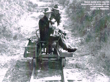
Photograph, R. Preston, Trolleying to work site, 1955, 14 December 1955
At its peak the Beech Forest railway employed more than 21 staff between Colac and Crowes. Gangers (men in charge of the track gangs) tended to be promoted into the Otways but many of their subordinate repairers were local recruits. A few of the men who worked in the original construction gangs of 1900-1902 remained and obtained positions in the track gangs along the line. The track was maintained by seven three-man gangs based at Colac, Barongarook, Gellibrand, Banool, Beech Forest (2), and Lavers Hill. However, track gangs lessened as the line shortened. After 1954, the sole surviving track gang, in charge of Paddy Balcombe, stayed until the line closed.A railway track gang, with helper, trolleying to a work site, on 14 December, 1955.beech forest; railways; track gang; -
 Bendigo Military Museum
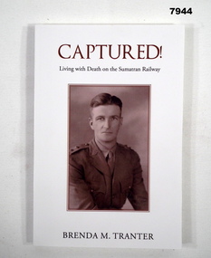
Book - BIOGRAPHY - WW2, Brenda M Tranter, "CAPTURED! LIVING WITH DEATH ON THE SUMATRAN RAILWAY", 2022
'"ARTHUR EDMUND TRANTER" Enlisted on 20/11/1939 Regt No. V50166 in the CMF, posted to 2nd Training Bn Balcombe. Discharged from the CMF 16/12/1940 with the rank of Sergeant in 2/7 Training Battalion. Enlisted in the 2nd AIF 17/12/1940 Regt No. VX52843 in 2/29th Battalion at Darnley Camp, embarked for Singapore 13.9.1941, disembarked 5.10.1941, reported missing 16.2.1942 then classified POW. He was recovered in Sumatra after the surrender. He was hospitalised with Malnutrition then classed Debility. Disembarked Sydney 9.10.1945. Discharged from the 2nd AIF on 20/12/1945 with the rank of Lieutenant. He was awarded a Mention in Despatches and the Efficiency Medal.Soft cover book. Cover - cardboard, white colour background, brown and black colour print on front, spine and back. Front cover illustration - sepia colour, half portrait of "A.E. Tranter". Back cover illustration - colour photograph two wreaths with railway line and sleepers. 168 pages, cut, plain white paper. Illustrated black and white photographs and maps. Attached after page 168 is one A4 sheet of paper, erratum of "Additional Research" information.publications, book, biography, ww2, arthur edmunt tranter -
 City of Moorabbin Historical Society (Operating the Box Cottage Museum)
Photographs, 7 x B&W Circa 1918 Cheltenham Methodist Youth Group, Circa 1918 Photos of Cheltenham Methodist Youth Group, 1918
Circa 1918: Various Photos of the Cheltenham Methodist Youth Group. Row 1 and 2: "At Flinders". Row 3: 1st Left, "Holidaying at Cockatoo". in 1852 Stephen Charman, who had arrived in Melbourne 1842 aged 21 years as one of Henry Dendy's emigrants, purchased 160 acres in Spring Grove ( now Cheltenham). Stephen and his family lived in a wattle and daub hut and worked hard to establish a market garden, poultry and pig farm. The first Methodist Church Services were held at their home. In 1855 Stephen gave 1 acre of his land on Balcombe Road to the Methodist Church for a School, Burial ground and a Chapel which was built in 1857.The Methodist Church, Balcombe Road was the 2nd religious building to be erected in Spring Grove now known as Cheltenham c 18577 small black and white photographs of the Cheltenham Methodist Youth Group at Flinders, Cockatoo and unkown locations, c 1918 . First 3 photos are of male cyclists on a trip to Flinders, Victoria. Photo 4 shows 6 ladies and a man on holiday at Cockatoo in the Dandenong Ranges ,Victoria . Photos 5 to 7 show men, women and children in bushland surroundings of unrecorded locations.Photo 1 - 3 on back : Flinders 1918 Photo 4 left on back : Holiday at Cockatoo right on back : Whitehead Photo 5-7 nilcheltenham, cheltenham methodist youth group, 1914, 1918, charman stephen, gettens mary, spring grove, methodist church, charman road, balcombe road, dendy henry, henry dendy's special survey 1841, youth groups, social groups, market gardners, early settlers, pioneers, dairy farmers, poultry farmers, pig farmers,moorabbin, brighton, -
 Melbourne Tram Museum
Ephemera - Rail & Tram weekly tickets, Victorian Railways (VR), c1935
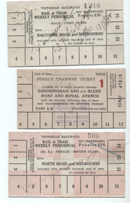
Set of three Victorian Railways Rail & Tram weekly Periodicals with conditions of travel on the rear, See reference page 124 and Figure 6-27. Such tickets were introduced on 1/7/1939. All tickets were available for 14 tram trips only, but unlimited rail trips: 1 - Balcombe Road and Melbourne - First Class - white card - No. 1346, marked cancelled 13/5/1939 2 - Sandringham and cnr Bluff Road and Royal Ave - white card - Male, No. 41618, price 1/3 with a red 1 (first class?) - stamped cancelled 3 - North Road and Melbourne - white card overprinted in pink to leave a cross, Female, No. 506, Second class, with cancelled hand written on the front.Demonstrates a Victorian Railways Rail and Tram weekly tickets for both their tramways and the changes made over time. May have been used for training samples.Set of three printed card tickets with over printing and hand writing as shown.tickets, vr, vr trams, victorian railways, st kilda brighton tramway, weekly tickets, sandringham to black rock -
 City of Moorabbin Historical Society (Operating the Box Cottage Museum)
Document,leaflet 'Brief History of the City of Moorabbin 1850 - 1934', 2015
2015 CMHS members D. Maynard. Fran & Holger Bader compiled this Leaflet to provide a condensed information Leaflet about the origin and development of the area known as 'The City of Moorabbin' from 1850 -1994. Topics ; Aboriginal Bunurrung people, Henry Dendy's Special Survey 1841 in County of Bourke ; J.B Were, land agent, Pastoralists/ Squatters John O'Shannassy, Richard & John King, Moysey Family, Alexander MacDonald; Parish of Moorabbin Land Developers 1850 J.Holloway, A. Balcombe, D.Wickham, S. Charman, Keys Family; Road District of Moorabbin 1862 - 1870; Shire of Moorabbin 1871 - 1934; City of Moorabbin 1934 - 94; Amalgamation of Councils 1994 divided the City of Moorabbin between the Cities of Glen Eira, Bayside, Kingston and Monash; Origin of suburb names,This Leaflet was compiled in 2015 to provide a condensed history of the area known as 'The City of Moorabbin' for visitors , schools and local community1 x A4 printed both sides, black and white, folded x 3page 1 'BRIEF HISTORY OF THE CITY OF MOORABBIN' ; CITY OF MOORABBIN /1934-1994 page 2 'CITY OF MOORABBIN / 1934 - 94 city of moorabbin, county of bourke, moorabbin roads board, parish of moorabbin, shire of moorabbin, henry dendy's special survey 1841, were j.b.; bent thomas, o'shannassy john, king richard, charman s, highett william, ormond francis, maynard dennis, -
 Melbourne Legacy
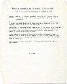
Document, Meeting of the Assessors of 1939 War Memorial Thesis Competition held at the Shrine of Remembrance on 23.12.47 at 4 pm, 1947
After the second world war there was a decision made to create a memorial for the 1939-45 War at the Shrine. A competition was held and 53 entries assessed. The first prize was shared between two submissions and the third prize money was also awarded. These two documents show that Legatee Kemsley was one of the Assessors who decided the basis of design for the memorial. The notes of a meeting of the Assessors show that Mr W. Balcombe Griffiths, Mr Marcus Martin, Colonel Kemsley and Sir Edmund Herring (Chairman of the Shrine Trustees) were present when the winning design was chosen. The design was later completed as the Forecourt in the shape of a paved cross, built in 1953, and the Cenotaph surmounted by a statuary group and the Eternal Flame. The memorial was dedicated and the flame set alight by Her Majesty Queen Elizabeth II on February 28 1954.A record of the decisions made by the committee that chose the design of the memorial for the 1939-45 war that was built as the Forecourt, the Cenotaph and the Eternal Flame at the Shrine of Remembrance. Legatee Kemsley was on the committee. White quarto paper with black type x 3 pages, two pages are a report to the Shrine Trustees on the competition for the design of the 1939 War Memorial and the third page is notes on a meeting of the Assessors of the competition.01187.2-3 Handwritten in pencil 'Shrine'. Title is: "Report of Assessors appointed to examine and award prizes from theses received in connection with the 1939 War Memorial Competition Conducted by the Shrine of Remembrance Trustees"memorial, cenotaph -
 Eltham District Historical Society Inc
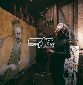
Photograph, Clifton Pugh - Dunmoochin, Cottles Bridge
A series of photos of Pugh at work. Clifton Pugh (1924-1990) was born at Richmond Victoria, and educated at various schools including Briar Hill Primary, Eltham Higher Elementary School and Ivanhoe Grammar. He studied art at the National Gallery School of Victoria 1948-52. Pugh is recognised as a one of Australia’s foremost painters. He is represented in major galleries throughout the country and overseas. He founded the “Dunmoochin” artists colony at Cottles Bridge. This front image from "Pioneers and Painters: 100 years of the Shire of Eltham" by Alan Marshall, page 128 shows Pugh working on his portrait of Dame Mabel Balcombe Brookes (1890-1975). According to an entry in the Australian Dictionary of Biography for Dame Brookes, this Pugh portrait remains in the family. This photo forms part of a collection of photographs gathered by the Shire of Eltham for their centenary project book, "Pioneers and Painters: 100 years of the Shire of Eltham" by Alan Marshall (1971). The collection of over 500 images is held in partnership between Eltham District Historical Society and Yarra Plenty Regional Library (Eltham Library) and is now formally known as the 'The Shire of Eltham Pioneers Photograph Collection.' It is significant in being the first community sourced collection representing the places and people of the Shire's first one hundred years.Digital image Various prints and colour reversal films artists, clifton pugh, cottles bridge, dunmoochin, eltham local characters, painters, "pioneers and painters", sepp, shire of eltham pioneers photograph collection, painting, dame mabel brookes -
 Melbourne Tram Museum
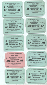
Ephemera - Set of 10 Bus Service Sandringham - Monthly Tickets, Victorian Railways (VR), 1964
Set of 10 Monthly tickets for the Sandringham based Co-ordinated Motor Coach service. See reference 165 and figure 7-78 for an example. Tickets were available for unlimited bus travel and were introduced in Sept. 1957. All dated July 1964 using blue card except for one dated June 1962 and most likely used as a training set. AF - Adult Female, AM - Adult Male 1 - Sandringham Beaumaris AF - 001, 002 2 - Sandringham Balcombe Rd AF 002, 004 and 005 3 - ditto - AM - 004, 005 4 - Sandringham - Royal Ave - AM - 001 5 - ditto - AF - 000 6 - Sandringham - Haydens Rd - June 1962, pink card - AM - unnumbered.Demonstrates a set of Victorian Railways monthly tickets used on the former Sandringham - Black Rock service replacement bus service.Set of 10 printed card tickets, all with trimmed or 45 degree corners.tickets, vr, vr trams, victorian railways, sandringham to black rock, buses, monthly -
 Melbourne Legacy
Document, History of Legacy 1946 (H19), 1946
A document summarising events significant to Legacy in the year 1946. With the return to peacetime the question of eligibility arose. The fundamental rule on which Legacy was based 'that of honourable service overseas' was clear cut in the case of the 1914-1918 war 'but much more difficult to define in the many and varied fields of service in the war which commenced in 1939'. Discussions were continued through the war at Annual Conferences. Many members believed that membership should be open to 'any male person who served as a member of the Forces of the British Empire irrespective of whether or not overseas service was involved'. And a resolution was passed at the 18th Annual Conference in Adelaide in 1946. Similar discussions of eligibility of Junior Legacy benefits was also discussed and definitions evolved. There was an increased need to help young widows with young children. First mention of the need to have a 'toddler home' for children from age 3 to 8. A property was acquired in Balcombe road with donation from the Trustees of 'Blamey House' - a war time hostel for servicemen which was being wound up and balance of funds being donated to Legacy. (Property acquired was 'Mossgiel' in Balcombe rd but renamed Blamey house due to the terms of the donation). Also the former Red Cross property of 'Stanhope' was made ready for the first residents welcomed in December 1946. Dureau House was under 'constant consideration'. (It seems the Dental Clinic was transferred here and there other part made available to the Melbourne Technical College - but in the 1950s it was still not suitable for Legacy's headquarters and sold). Classes during the war had been difficult to find suitable halls, and 43 Market St was still being used by the Air Force. A superannuation scheme was instituted for the Legacy staff. The notation H18 in red pen shows that it was part of the archive project that was trying to capture the history of Legacy. A report covering the main work of Legacy in 1946.White foolscap paper with black type x 5 pages of the achievements of Legacy in 1946.Handwritten 'H19' in red pen.history, annual summary -
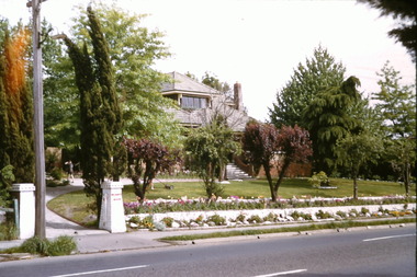
 Bayside Gallery - Bayside City Council Art & Heritage Collection
Work on paper - ink and watercolour, Annette Meikle, Black Rock House, 1977
In 1977, artist Annette Meikle undertook a commission to illustrate a book recording stories of places and people in the Bayside area. It was published in 1978 as Sandringham Sketchbook, with text by Elizabeth Waters. The sketches were intended to record remaining examples of Bayside’s early architecture and environment, as well as reflect newer architectural changes. Meikle went on to donate 22 of these sketches to Bayside City Council in 2003. Black Rock House was built in 1858 by wealthy land dealer and politician Charles Hobson Ebden as a holiday home on 112 acres of virgin scrub, taking in the area of present day Balcombe Road, Beach Road and the line of Keating Street. The house included four bedrooms, a cellar, stables and a courtyard enclosed in castle-like sandstone walls. It was named Black Rock House after Black Rock Castle near Dublin, associated with Mrs Ebden’s childhood.Annette Meikle, Black Rock House 1977, ink and watercolour, 33 x 53.5 cm. Bayside City Council Art and Heritage Collection. Donated by the artist, 2003annette meikle, sandringham sketchbook, elizabeth waters, black rock house, black rock, charles hobson ebden, architecture, historic house -
 Melbourne Legacy
Slide, Blamey House, 1960s
Blamey House was one of the residences used by Legacy as a home for Junior Legatees. From 1942-1981 Legacy provided residential accommodation for junior legatees who may have been left orphans, or whose mother may have been unable to care for them herself, or they needed to stay in Melbourne for further education. Short term accommodation for children could be provided, for instance if a widow needed hospital care. The property at 1267 Burke Road was known as Holmbush from 1942 until 1956. The name was transferred to this property from another residence in Balcombe Road Beaumaris when it was sold in the mid 1950s. Was with many other slides taken in the 1950s and 1960s. The slides have been photographed to make digital images and moved to archive quality sleeves. In many cases the original images were not well focussed and the digital image the best available.A record of the residence in Burke Road named Blamey House.Colour slide of Blamey House viewed from the road in a red edged Kodachrome cardboard mount.Printed on reverse in red ink 'Kodachrome Transparency / Processed by Kodak'. Handwritten in blue ink 'Blamey House'. Imprinted slide number in black ink '1'.residences, blamey house -
 Melbourne Legacy
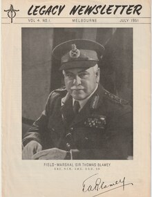
Magazine - Newsletter, Melbourne Legacy, Legacy Newsletter July 1951, 1951
The newsletter from July 1951. It featured former Sir Thomas Blamey on the cover. The president's introduction talked of the death of Sir Thomas Blamey and his career. There was a piece on the Legacy residence named after Blamey with photos of the residence in Balcombe Road, Black Rock. Pages showed news from the different Boys and Girls Classes and suggested physical exercises. Plus a piece on the Mothers' Club and the Intermediate Club activities. A newsletter published by Legacy in this format for many years from 1942. It mentions "Issued from time to time for Private Circulation among the Sons and Daughters of Deceased Service men and Merchant Seamen who served their Country during the War of 1914-18, or the present War". Many articles on the work of Legacy, including features on boys classes, girls classes, camps, the residences and where their past residents ended up. There are some suggestion for careers and some general interest articles. Some very interesting photos.Newsletter outlining news of Junior Legatee activities.Black and white printed newsletter x 8 pages from July 1951. Volume 4 Number 1boys classes, activities, girls classes, ilc -
 Bendigo Military Museum
Album - PHOTOGRAPHS WW2, Post 1945
These photos were taken at Training Camps in Australia, Shepparton, Royal Park, Darby Camp, Balcombe, Alice Springs, NT, Larrakeyah, Darwin, Bombing of Darwin, Alice Springs, Adelaide River, New Guinea. There is several interesting photos of damage to Darwin Hotels by AIF units disgruntled at not being sent overseas. Allen Edward Malone VX46797 enlisted in the AIF on 13.7.1940, allotted to 8th Division, transferred to 2/4th Australian Field Workshops 8.2.1941, Moved to the NT arriving 8.5.1941, unit renamed 23rd Independant Group Ordnance W/Shops, moved to QLD 4.6.1943, posted to 2/137 Brigade W/Shops, promoted A/Cpl 26.6.1943, embark 12.7.1943 for New Guinea, detached for duty with 6th Aust Field Ambulance (Had previously done this with prior unit as a medical Orderly) Promoted Cpl 8.12.1943, Leave to Victoria 5.11.1944, embark at Townsville for New Britain 2.2.1945, disembark Brisbane 5.6.1945, discharged from the AIF 28.11.1945.1) Cover for Album, cardboard with a buckram finish, all black colours. .2) Album black covers, black pages with white glassien tissue sheets between each page, rear cover page has a envelope for a disc. Pasted on inside front cover is an A4 sheet typed with the service details re the owner and when taken, 20 pages have photos on with photo corners, photos have details written in white pen under them.On first page in white pen, "A.E. Malone Photo Album - photos taken during War service 1940 - 1945. Many of the photos were taken and developed by A.E. Malone"album ww2, malone collection -
 Bayside Gallery - Bayside City Council Art & Heritage Collection
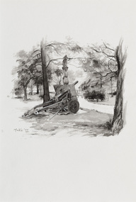
Work on paper - ink and watercolour, Annette Meikle, Beaumaris RSL, 1977
In 1977, artist Annette Meikle undertook a commission to illustrate a book recording stories of places and people in the Bayside area. It was published in 1978 as Sandringham Sketchbook, with text by Elizabeth Waters. The sketches were intended to record remaining examples of Bayside’s early architecture and environment, as well as reflect newer architectural changes. Meikle went on to donate 22 of these sketches to Bayside City Council in 2003. This gun stood in the grounds of the Beaumaris RSL, located on the highest hill in Beaumaris – more than 300 metres above sea level. The ‘25-pounder’ was one of the best field guns of its day and was used by British and Commonwealth armies during the Second World War. The original ten-acre property, which was the former holiday home of wealthy Toorak resident Langford-Jack, was sold to the Legacy Club in 1942 and operated as a holiday home for Legacy children. Renamed Blamey House in honour of Field-Marshall Sir Thomas Blamey, it was purchased by the RSL in 1955. The Beaumaris RSL Club closed its doors on Balcombe Road in 2016 after the property was sold in 2013.Annette Meikle, Beaumaris RSL 1977, ink and watercolour, 33.8 x 23.5 cm. Bayside City Council Art and Heritage Collection. Donated by the artist, 2003annette meikle, sandringham sketchbook, elizabeth waters, beaumaris rsl, 25-pounder, field gun, military weapon, langford-jack, blamey house, balcombe road, beaumaris -
 Surrey Hills Historical Society Collection
Photograph, Doris Wright, member of the Australian Women's Army Service
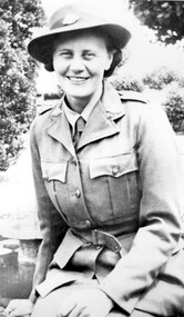
Doris Lilian Wright of 214 Union Road was a milliner but joined the Australian Women's Army Service (AWAS) in the early war years. The Women’s Australian National Service (WANS) was inaugurated in 1940. Training for members of the WANS included air raid drills, first aid, basic military drills, and even shooting, signalling, and mechanics. AWAS on formed on 13 August 1941 with the objective of releasing more men into forward areas. The Army was particular with its recruiting and four references were required; another stipulation was that teeth were in good condition. Doris was located at Elwood. Their training area was along the foreshore and one day to their great surprise there were crowds of American Marines – "the cream of the American Army". These were the first Americans to arrive in Australia to strengthen the defence of the country. The Americans soon went north and the AWAS went off to Balcombe on the Mornington Peninsula. At this time there were no uniforms for the girls only ‘giggle’ dresses – of a non-descript colour. They were not expected to appear in public in these and wore civilian dress. Japan had just entered the war and there were more urgent demands on restricted supplies. The formal uniforms eventually arrived.A black and white photograph of a lady in an army uniform and wearing a hat.union road, surrey hills, uniforms, clothing and dress, (miss) doris wright, australian women's army service -
 City of Moorabbin Historical Society (Operating the Box Cottage Museum)
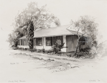
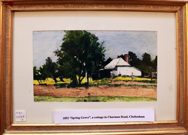
Print - 'Spring Grove' 19thC house, c1979
In 1852 Stephen Charman purchased 160 acres bounded by Charman Rd and Balcombe Road in an area called Spring Grove, later Cheltenham. A spring ran through the land providing a good source of water. Stephen aged 21 years had arrived in Melbourne 1842 as one of Henry Dendy’s emigrants . His Ship passage was paid by the Colonial Land and Emigration Commission and in return he was required to work on the land of the Henry Dendy Special Survey Brighton 1841. However Henry Dendy could not provide enough work for all the emigrants that arrived and Stephen had to obtain other work. Then sadly his young wife Harriett and their infant died. 1850 Stephen married widow Mary Gettens, a Publican in Little Collins Street, with 5 children. Stephen & Mary built a wattle and daub hut and established a market garden producing marigolds for Martin & Pleasance Pharmacists, Melbourne. They had 7 more children and built a weatherboard cottage that was used for early Methodist Church services. Stephen donated 1 acre to the Methodist Church in 1855 for Chapel , School and Cemetery. The picture of the weatherboard cottage was on, a road which runs from Cheltenham to Mentone it bears their name. Charman Road. Mary died in 1870 and Stephen remarried 1878 and died in Gippsland 1906. Stephen and Mary Charman were pioneer settlers in the area of Spring Grove later known as Cheltenham . Charman Road Cheltenham commemorates their contribution to the development of the area. A painting of 'Spring Grove' the home of Stephen Charman and Mary Charman formerly Gettens nee Rees, This cottage was the first house in Charman Road Cheltenham c1852signed L Schumerspring grove cottage 1852, schumer l, cheltenham, charman stephen, early settlers, jones a l, gettens mary, rees mary, charman mary, moorabbin, brighton -
 City of Moorabbin Historical Society (Operating the Box Cottage Museum)
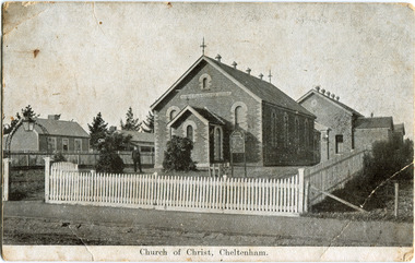
Photograph - Black & White Postcard, Cheltenham Church of Christ 40th Anniversary Invitation, c1900
On his arrival from Scotland c 1857, James Keir commenced a communion service in his home on the Nepean Road. By 1859 the group-which included such other names as Allen, Brough, Cameron, Fairlam, Holdsworth, Le Page, Meeres, Monk, Organ, Penny, Perry, Potts, Sears and King-had built a small chapel near the corner of Wickham and Chesterville Roads. During 1858, a group had also begun meeting in the Charman family home on the corner of Charman and Balcombe Roads. Names associated with this group included Bodley, Charman, Fisher, Hayes, Hilliar, Judd, Moysey and Ruse. In 1860 they built a chapel on the corner of Charman Road and Patty Street. It was enlarged in 1866 and it became the meeting place of the two groups when they came together around 1870. They were able to buy land near the corner of Chesterville and Nepean Roads, and erected a new brick chapel on the site in 1878. This chapel, of course, continues to be an integral part of the life of the Southern Community Church and was one of the three worship venues for the 150th Anniversary celebration in 2007. The Southern Community Church was formed by the amalgamation of the Cheltenham, East Bentleigh and Hampton Street Churches of Christ in 1993, and a comprehensive new facility was designed and built to accommodate the ever-increasing activity of the amalgamated church. It was opened on 30th November 1997. ( Southern Community Church website 2019)c1878 - continuing The Church or Christ Cheltenham was one of the first places of worship established in Cheltenham by the early settlers. The settlers came together, in private homes at first, to support each other spiritually and physically and later built brick Churches for Sunday services and established social and sporting clubsBlack & White photograph as a postcard invitation to the 40th Anniversary of the Church of Christ corner Chesterville Rd and Nepean Highway Cheltenham ( ? 1900)Front Printed ; Church of Christ Cheltenham Back Printed ; POST CARD / One Penny Postage within Commonwealth / The address only to be written here/ One penny Stamp/ Sunday School Anniversary, / OCTOBER 27TH & OCTOBER 30TH / TO WHICH YOU ARE / CORDIALLY INVITED Handwritten in ink ; H.W. got the cramps in the pants. He took some pills then ran over the hills undatedearly settlers, bentleigh, mckinnon, parish of moorabbin, city of moorabbin, county of bourke, moorabbin roads board, shire of moorabbin, were j.b., o'shannassy john, king richard, charman stephen, highett william, ormond francis, maynard dennis, market gardeners, vineyards, orchards, keir james, lepage frank, lepage everest, holloway josiah, bruton henry, keys robert, judd clarence, fairlam percy, meeres william, southern community church, cheltenham, cheltenham church of christ -
 City of Moorabbin Historical Society (Operating the Box Cottage Museum)
Clothing - Clothing, City of Moorabbin Tie, Circa 1960s
The City of Moorabbin existed from 1934 until 1994. Henry Dendy's Special Survey in 1841 of 5,120 acres in the Parish of Moorabbin , extended from Port Phillip Bay , then East to Boundary Road, South to South Road and North to North Road and became known as Brighton. 1859 Brighton became a Borough with its boundary Thomas Street ,and Bluff Road. In 1862 The Moorabbin Roads Board was formed and the extended area now included Cheltenham, Hampton, Sandringham, Black Rock, Beaumaris, Mentone and Mordialloc .and Little Brighton became known as Bentleigh. In 1871 the area became known as The Shire of Moorabbin. Gradually the area was separated into The Borough of Sandringham 1917, ( Black Rock, Beaumaris , Sandringham and Hampton ) Borough of Mentone and Mordialloc 1920, ( Parkdale ). In 1934 The City of Moorabbin was established for the area from South East corner of Thomas Street and North Road , East to Warrigal Road, Clayton Road, Kingston Road , Lower Dandenong Road, then South along Nepean Highway to Balcombe Road and along Bluff Road, Cummins Road, Nepean Highway, Thomas Street to North Road In the 1994 Amalgamation of Councils the City of Moorabbin was divided between the new City of Kingston in the South ( from South Road) and the new City of Glen Eira to the North . It was the largest Municipality in Victoria with a population of 118,865 in 1974This tie c 1960 is a memento of the City of Moorabbin 1934 - 1994Maroon colour, polyester, man's tie with the crest of City of Moorabbin woven on front.around circle enclosing Coat of Arms ; CITY OF MOORABBIN city of moorabbin, moorabbin roads board, moorabbin, brighton, dendy's special survey 1841, early settlers, pioneers, market gardners, dendy henry, were jonathan b, cheltenham, bentleigh, mentone, sandringham, mair william, bent thomas -
 City of Moorabbin Historical Society (Operating the Box Cottage Museum)
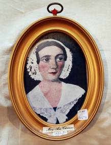
Print - Mary Ann Charman 1820 - 1870
Mary Ann Charman was a pioneer settler in the Cheltenham area of the Parish of Moorabbin c1850 Stephen Charman , who emigrated in 1942 as a Henry Dendy employee aged 21 years, sadly lost his wife and child shortly after arriving in Brighton. When Dendy could not employ him he found other work. In 1850 he met Mary Gettens a widow with 5 children who supported her family by managing her late husband’s Inn in Collins St. Melbourne. Stephen purchased land in Spring Grove, now Cheltenham, in 1852 and the family moved to the wattle and daub hut after their marriage. Mary and Stephen worked very hard to establish a market garden, poultry and pork farm . They specialised in Marigolds which they sold to Martin & Pleasance Pharmacy , Melbourne for medicinal purposes. Mary and Stephen had 7 more children and Mary still managed to find time to sell the pork, poultry and vegetables from a horse drawn cart she drove around St Kilda. 1857 Stephen donated land to the Methodist Church for a School, burial ground and Chapel in Balcombe Road. Mary died 1870. Stephen remarried in 1878 and died aged 85 years 1906. Charman Road runs from Nepean Highway , Cheltenham through Beaumaris to the Beach Road at Mentone. Mr Les Jones was the Great Grandson of Mary Ann CharmanAn oval framed colour copy of a painting of the likeness of Mary Ann Charman, 1820 - 1870 pioneer settler in the Cheltenham area of the Parish of Moorabbinpioneers, early settlers, dendy henry, charman mary ann, jones les, cheltenham, moorabbin, brighton, market gardeners, dairy farmers, charman road -
 City of Moorabbin Historical Society (Operating the Box Cottage Museum)
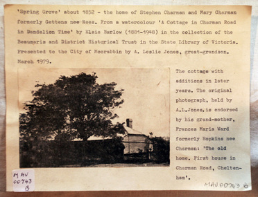
Document - Photograph, photocopy, of ‘Spring Grove’ 19th C house, Charman Road, Cheltenham, c1979
In 1852 Stephen Charman purchased 160 acres bounded by Charman Rd and Balcombe Road in an area called Spring Grove , later Cheltenham. A spring ran through the land providing a good source of water. Stephen aged 21 years had arrived in Melbourne 1842 as one of Henry Dendy’s emigrants . His Ship passage was paid by the Colonial Land and Emigration Commission and in return he was required to work on the land of the Henry Dendy Special Survey Brighton 1841. However Henry Dendy could not provide enough work for all the emigrants that arrived and Stephen had to obtain other work. Then sadly his young wife Harriett and their infant died. 1850 Stephen married widow Mary Gettens, a Publican in Little Collins Street, with 5 children. Stephen & Mary built a wattle and daub hut and established a market garden producing marigolds for Martin & Pleasance Pharmacists, Melbourne. They had 7 more children and built a weatherboard cottage that was used for early Methodist Church services. Stephen donated 1 acre to the Methodist Church in 1855 for Chapel , School and Cemetery. This is the weatherboard cottage in the photocopy showing the building extension, The road between Cheltenham and Mentone bears their name. Mary died in 1870 and Stephen remarried 1878 and died in Gippsland 1906. The original Photograph is endorsed by Francis Marie Ward , formerly Hopkins nee Charman who was the grandmother of Mr A.L Jones A photocopy of a black and white photograph of ‘Spring Grove’ , that was the first house in Charman Road , Cheltenham c1852 , showing later extensions. spring grove cottage 1852, schumer l, cheltenham, charman stephen, early settlers, jones a l, gettens mary, rees mary, charman mary, moorabbin, brighton, henry dendy special survey 1841, ward frances marie, charman frances marie -
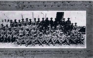 Lara RSL Sub Branch
Photograph of A Company 2/21st Battalion Australian Infantry, c July to September 1940
Black and White photo Company "A" 2/21Rare item of historical value due to the battallion being taken prisoner by Imperial Japanese soldiers at Ambon. The Australians suffered at the hands of their captures.Photograph of members of " A" Company 2/21st Battalion Australian infantry Taken in Melbourne. Vic. Group portrait of A Company, 2/21st Battalion. Left to right: front row: Chafer, Hartley, Bailey, Fisher, Breen, Marsh, Lance Corporal (L Cpl) Billings, Smith, Knuckey, McKenzie, Wilson, Dallagh, Jones, Redwood, Turnbull, Rutley, Minetti, Gravener and Corporal Borr (?). Second row: Winter, Brander, M.F. Osborne, V.F.H. Hubbard, Gladigou, Alison, Davies, Blair, Edney, Tuddenham, B. Tucker, Sergeant (Sgt) Stanbridge, Captain (Capt) Wesley, Lieutenant (Lt) Thomas, Sgt Stayte, Beachley, Hallowell, A. Osborne, Thatcher, Watson, unidentified, Ericson, Hadlow, Tucker, McGregor, C.R. O'Bryan and Bradley. Third row: Walker, R.R. Hubbard, Hutchins, L Cpl Kirwan, Mason, J.M. Francis, Corson (?), Leslie, Dunbar, Arnold, Inkster, Balcombe, Corporal Leary, Beckwirth, Barclay, Blanks, Conway, Bolwell, Rigney, Orange, Taylor, Dihood, Mitchell, Donchi, Howard, Flintoff, Hill, Capon, Lewin, L Cpl Eouid (?), Sgt Jacobs. Fourth row: Sgt Seabrooke, Privates King, Jorgenson, O'Halloran, Simmons, Amesbury, Kofoid, Daff, L Cpl Guest, Cooke, Ordish, Stratton, three cooks named Keel, Tullett and Brown, Privates Turner, Dahlberg, Uren, Ansett, Moran, Fry, Penny, Phillips, Lock, Loch, Perrin, Snodgrass, Argus, Gee, Corp Boyce.Photo and frame A Coy 2/21 with names inscribed there on. Black ans white photo by H.M. Walker, Wentworht House, 203 Collins Street, Melbourne.a coy 2/21 battallion -
 Eltham District Historical Society Inc
Photograph, Mulberry Hill, Golf Links Road, Baxter; Spring Excursion to The Briars and Mulberry Hill, 27 October 1991, 27/10/1991
[from EDHS Newsletter No. 80, September 1991:] SPRING EXCURSION: As usual for October we have arranged a bus tour outside the local area. We will leave from the Eltham Shire Offices at 9.00 am on Sunday 27th October and travel to "The Briars" at Mornington and "Mulberry Hill" at Baxter. The cost will be $16.00 for adults and $8.00 for children. This includes admission to each of the houses and afternoon tea at "Mulberry Hill". Bring your own lunch to eat at "The Briars" and something for morning tea if you wish. "The Briars" is one of the oldest pastoral stations on the Mornington Peninsula. It has historical associations with the early settlement of the district and with Alexander Balcombe who settled in the area about 1843. Near the house is a wetland wildlife reserve with walking paths and bird observation hides. "Mulberry Hill" was the home of Sir Darryl Lindsay and his wife Joan. Darryl (1889-1976) was a member of the famous art family of Lindsays and was a prominent artist in his own right. He was also a noted art administrator, being appointed Director of the National Gallery of Victoria in 1942. Joan Lindsay (1896-1984) was an important writer. Her best known work was "Picnic at Hanging Rock". Members may find it interesting to read her autobiography "Time Without Clocks" prior to this trip. Members are welcome to bring their friends. Bookings will only be confirmed on payment. Please complete the attached form and return with payment to the September meeting or to our post office box. The trip is still some time off but there is no further Newsletter before then. Note the date in your diary how. As this will probably be the first day of daylight saving you will need to remember that in organizing yourself on the day. Please arrive at 8.45 am ready for a prompt start at 9.00 am.Two colour photographsactivities, mulberry hill, the briars -
 Bendigo Military Museum
Photograph - RASvy Surveyors in the field, c1950s – 1960s
This is a set of 1photographs of surveyors in the field measuring distances using chains, taking observations using theodolites and operating electric distance measurement equipment. They were probably employed in establishing mapping and geodetic control operations or the surveyors may have been in training. The photos were most likely taken in the 1950s and 1960s. Photos .1P to .6P feature personnel setting up geodetic survey chaining equipment to measure distances. The surveyor in Photo .5P is LTCOL Howard Angus Johnson MBE who served from 1936 to 1954. The RA Svy surveyor in photos .7P to .12P were using a theodolite to take angular measurements. They were usually supported by an observer who recording their readings on a booking form. The surveyor in Photo .10P and .11P is LTCOL Jorge Gruszka, who served from 1955 to 1985. He was CO of the Army Survey Regiment from 1982 to 1985. The surveyor in photo .13P is cutting an identification blaze on a tree using a hammer and chisel. The tellurometer in Photos .14P to .16P was a MRA1 microwave Electronic Distance Measuring instrument (EDM) introduced in 1958. It and later models were man-portable systems that improved geodetic survey efficiencies for rapid network extension and densification replacing triangulation with EDM and theodolite traverse sometimes using Bilby Towers to extend line lengths. The surveyor with the slouch hat is Colonel James ‘Jim’ Leslie Stedman, who served from 1941 to 1978. He was Director of Military Survey from 1975 to 1978 and was appointed as Colonel Commandant (honorary appointment, Retd) of the Royal Australian Survey Corps from 1978 to 1983. Jim Stedman is demonstrating EDM equipment.This is a set of 17 photographs of surveyors in the field measuring distances using chains, taking observations using theodolites and operating electric distance measurement (EDM) equipment. c1950s – 1960s. The photographs were printed on photographic paper and are part of the Army Survey Regiment’s Collection. The photographs were scanned at 300 dpi. .1) - Photo, black & white, c1950s, unidentified personnel using geodetic survey chaining equipment. .2) to .4) - Photo, black & white, c1950s, geodetic survey chaining equipment. .5) – Photo, black & white, c1950s, Jim Stedman using geodetic survey chaining equipment to measure distances. .6) - Photo, black & white, c1950s, Unidentified personnel geodetic survey chaining equipment. .7) – Photo, black & white, mounted on card, c1950s. Unidentified surveyor undertaking observations on a coral reef using a theodolite. .8) – Photo, black & white, c1950, unidentified surveyor undertaking observations with a Tavistock theodolite. .9) – Photo, black & white, mounted on green card, c1950s. Unidentified surveyor undertaking observations using a plane table. .10) – Photo, black & white, c1955, Jorge Gruszka undertaking observations with a theodolite. 7/55 Basic Survey Course Balcombe. .11) – Photo, black & white, c1950s, Jorge Gruszka undertaking observations with a theodolite. .12) – Photo, black & white, c1946-1948, unidentified surveyor undertaking observations with a theodolite to gain control for the mapping of the Snowy Mountain Diversion Scheme. .13) – Photo, black & white, c1950s, unidentified surveyor cutting a blaze in a tree. .14) and .15) – Photo, black & white, c1960s, Jim Stedman demonstrating EDM equipment. .16) – Photo, black & white, c1960s, L to R: Jim Stedman (probably) and unidentified surveyor demonstrating EDM equipment. .17) – Photo, black & white, 1956, Operation Cutlass - Surveyors SPR W. Crane and J.A. Campbell undertaking observations with a theodolite in extreme conditions..1P on back - First Order Chaining Equipment .2P on back - First Order Chaining Equipment .3P on back - Full catenary 1800 – 1960 replaced by EDM .4P on back - First Order Chaining Equipment .5P on back - H.A. Johnson, Benambra baseline? 1st Order Chaining .6P on back - Chaining .7P on front - Difficult observing conditions especially when the tide is in. The station is sighted (sic) on a coral reef. .8P on back - Tavistock. .10P on back of duplicate in Photo Folder 14 – George (sic) Gruszka 7/55 Basic Survey Course Balcomme (sic) 1955/56 .14P and .15P on back - Jim Stedman demonstrating early EDM equipment.royal australian survey corps, rasvy, army survey regiment, army svy regt, fortuna, asr, surveying -
 Bendigo Military Museum
Photograph - Johnson Ground Elevation Meter (JGEM) Survey Vehicle - Army Survey Regiment, Fortuna, Bendigo, c1960s
This is a set of 16 photograph of the Royal Australian Survey Corps’ Johnson Ground Elevation Meter (JGEM) Survey Vehicle taken at the Army Survey Regiment, Fortuna, Bendigo. The JGEM vehicle was extensively used by RA Svy within Australia from the late 1960s. A limited number of Ground Elevation Meter (GEM) station wagon type vehicles were manufactured by General Motors Corporation (GMC) in the USA for the United States Geological Survey, Canada’s mapping agencies, RA Svy and National Mapping (Natmap). The GEM was a four-wheel drive, four-wheel steer vehicle. Four-wheel steering was necessary to avoid systematic errors caused by non-tracking of front and rear wheels on conventionally steered vehicles. The manufacturer substituted the rear axle with a front axle and connected them to form the four-wheel steering mechanism. The two Australian GEM vehicles, referred to as Johnson GEMs (JGEMs) were converted into right-hand drive. After delivery in 1964, acceptance Natmap and RA Svy testing and operator training was undertaken at the Army's School of Military Survey located at Balcombe, Victoria. A small fifth wheel was mounted on a cantilever arm suspension midway between the front and rear wheels on the right side of the vehicle. It was lowered to and raised from its operating position by use of a constant pressure air cylinder. A telescopic bar, suspended between the front and rear axles, provided the reference datum for the angle measurement. The wheel provided the velocity or distance signal through a pulse generator system. A sensitive pendulum mounted on this bar provided the angle measurement for each minute distance traversed. The JGEM contained electromechanical instruments used to determine relative elevations, by trigonometric principles, along a traversed path. These relative elevations were obtained through apparatus which measures the instantaneous angle of inclination of the road and the instantaneous velocity of the meter along such a path. Road routes over which the JGEM operated were planned so that each started and ended as near as practicable to an existing point of known elevation (formally referred to as a level traverse bench mark). The difference in height from the bench mark and the road surface alongside the JGEM’s fifth wheel was measured with a level and staff. Along each route, mapping control photo reference points where new elevation values were required were identified on aerial photographs. Under favourable conditions it was possible to survey as much as 160km in an ordinary working day. The first of RA Svy’s JGEM operations was undertaken in 1:250,000 scale map areas of Queensland. CPL John Hook was the JGEM’s main operator in the early 1970s undertaking operations covering 1:250,000 scale map blocks over northern Victoria and central NSW, each requiring 36 points (9 runs of photography and 4 points across. SPR Lyn Thompson and SPR Bob McDonagh teamed with CPL Hook on some of these JGEM operations. When RA Svy was integrated into the Royal Australian Engineers in 1996, the JGEM vehicle with the Survey Corps collection was donated to its museum. It is believed to be the last of the original manufactured fleet in existence. The JGEM has undergone extensive refurbishment to achieve roadworthiness and is currently housed at The Australian Army Museum of Military Engineering, Hoslworthy Barracks, NSW. It can be viewed by making an appointment with the museum’s curator.This is a set of 16 photograph of the Royal Australian Survey Corps’ Johnson Ground Elevation Meter (JGEM) Survey Vehicle taken at the Army Survey Regiment, Fortuna, Bendigo. The photographs were on 35mm slide film and were scanned at 96 dpi. They are part of the Army Survey Regiment’s Collection. .1) - Photo, colour, c1960s, Johnson Ground Elevation Meter (JGEM) Survey Vehicle .2) - Photo, colour, c1960s, JGEM instrumentation, on-board computer. .3) - Photo, colour, c1960s, JGEM instrumentation. .4) - Photo, colour, c1960s, JGEM instrumentation, on-board computer. .5) - Photo, colour, c1960s, JGEM tyre pressure controller .6) - Photo, colour, c1960s, JGEM rear doors, SGT Geoff Briggs. .7) - Photo, colour, c1960s, JGEM 5th wheel distance/angle measurement device in lowered position, SGT Geoff Briggs. .8) - Photo, colour, c1960s, JGEM 5th wheel distance/angle measurement device in lowered position. .9) & .10) - Photo, colour, c1960s, JGEM tyre pressure system, SGT Geoff Briggs. .11) - Photo, colour, c1960s, JGEM tyre pressure system. SGT Geoff Briggs. .12) - Photo, colour, c1960s, JGEM levelling scope, levelling staff, unidentified technicians. .13) & .14) - Photo, colour, c1960s, JGEM levelling scope, unidentified technician. .15) & .16) - Photo, colour, c1960s, probably survey operation adjusted height plotted on block base sheet. .1P to .16P - Some of the equipment is annotated on the frame of the 35mm slides.royal australian survey corps, rasvy, army survey regiment, army svy regt, fortuna, asr, surveying -
Glen Eira Historical Society
Letter - Rosstown Railway
This file contains four items: 1/A black and white photocopy of a letter dated either 07/08/1889 or 09/08/1889, from Robert Lundon to an unidentified recipient discussing an agreement reached between the author – on behalf of the recipient – and Soon Hang Hi in regard, in regards to the allotment known as Webber’s. The agreement is outlined in the letter in what appears to be Chinese characters, and includes the marks of Robert Lundon and Soon Hang Hi. File note from Joy Wu states that the calligraphy is not Mandarin or traditional Chinese. 2/Three sheets of hand-written working notes with information taken from the Victorian Government Gazette on THE ROSSTOWN AND MURRUMBEENA LAND COMPANY LIMITED, THE ROSSTOWN JUNCTION RAILWAY AND PROSPERITY COMPANY LIOMITED, and THE ROSSTOWN JUNCTION, ELSTERNWICK, AND OAKLEIGH RAILWAY COMPANY LIMITED, covering dates between 1887 and 1894. The notes concern meetings and creditors claims relevant to the companies, with reference numbers for the information source. Date and author of the notes are not recorded. 3/A black and white photocopy of the a partial map of the Rosstown Railway and surrounding area, undated. The map includes the names of landholders in the areas of Brighton, Garden Vale and Elsternwick, as well as other railway lines present in the region. 4/A fold-out map and guide of the Rosstown Rail Trail, including a brief general history of Caulfield as well as a more extensive biography of William Murray Ross and the Rosstown Railway. The map marks and describes significant sites along the trail, including photographs of some of these sites, provided by DF Jowett.documents, correspondence, webber’s, lundon robert, chinese characters, ethnic communities, signatures, text, settlements, taxes, fraser john grieves, lovell r.h., price davies, meetings, communication activities, soon hang hi, commercial events and activities, the rosstown and murrumbeena land company limited, victorian government gazette, bulmer richard, parry john, osment henry, shareholders, creditors claims, the rosstown junction railway and property company limited, finch and best, lawyers, the rosstown junction elsternwick and oakleigh railway company limited, cameron w.c., phillips p.d., garden vale, elsternwick, elsternwick railway station, rosstown, rosstown railway, thomas street, bay street, kooyong road, melbourne and brighton railway, hawthorn road, bambra road, caulfield and frankston railway, booran road, grange road, koornang road, murrumbeena road, north road, north road railway station, east brighton railway station, south road, railway routes, railway lines, railways, land transport, murphy j., caulfield, hamilton t.f., dane p., holloway, webb, ailee john, payne t.b., brodie chas, dane john, o’neil h., mccombie john, mcmillane a., smyth c.d., cooper, ebden, landholders, jeffrey j.d., gill j., balcombe a.e., cooper h., mcnab j., white j., sutherland j., greeves a.f.a., newton m.c., chamley f.b., fowler j., inglis p., grant t., stooke j., swanson g., cochrane c., adams e.b., mccombie thas, keyes robert, brighton cemetery, burials grounds and graveyards, war-ein road, were j.b., holland j., mcmahon c., winter t.l.m., dendy henry, mitchell w., jackson s., were j.e., wickham francis dawe, bryant jane, east brighton railway station, railway stations, maps, allotments, land titles, roads and streets, rosstown rail trail, city of glen eira, tourism, trains, tourism information bureaus, tours, pamphlets, elsternwick railway park, oakleigh junction, princes park, ee gunn reserve, packer park, sites, jowett d.f., weickhardt i.g., return to rosstown: railways land sales and sugar beet ventures in caulfield, land sales, walking trails, ross william murray, transport objects, locomotion, walking, cycling, driving, sports, country mansions, people, caulfield john, builders, construction and demolition workers, occupations, careers, professionals, topography, geology, landforms, horticulture, market gardens, primary industry workers, city of caulfield, mood kee, pennington harold, annual general meetings, caulfield town hall, glen eira city council, carnegie, carnegie station, rosstown station, people by circumstance, migrants, sugar beet, sugar beet mill, sugar beet industry, mills, factories, sea beach lines, bent thomas, parliamentary representatives, neville street, miller street, lemann’s swamp reserve, koornang park, cane sugar industry, breweries, rabbit processing plants, health establishments, hospitals, food production establishments, abattoirs, thieves, social problems, vagrants, theft, squatting, financial economics, debt, finance industry, insurance companies, company managers, bentleigh, ross leila, the grange, leila road, wild cherry road, financial trouble, mortgages, gisborne street, archibald street, riddell parade, victoria railways, glen huntly road, clarence street, college street, gladstone parade, parrell street, aileen avenue, seaview street, drion estate, land subdivisions, dover street, sussex street, landfill, marara road, booran road, woodville avenue, dorothy avenue, ormond park, royal avenue, ormond railway station, oakleigh road, melten avenue, miller street, munro avenue, lord reserve, neerim road, toolambool road, the rosstown hotel, rosanna street, murrumbeena crescent, commercial establishments, the national bank, rosstown road, kangaroo road, poath road, freda street, hughesdale kindergarten, oakleigh council, hughesdale community centre, civic establishments, galbally reserve, plaques, warrigal road, out and about brochures -
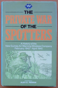 Australian Commando Association - Victoria
Book, The Private War of the Spotters: A history of the New Guinea Air Warning Wireless Company, February 1942-April 1945
The history of the New Guinea Air Warning Wireless Company. This reprinted version contains a map of the dispositions of Spotting Stations August 1943, additional MID awards listed and some additions to the nominal roll. The New Guinea Air Warning Wireless Company was formed in Port Moresby in late January 1942 and was granted “Separate Independent Establishment” status in October 1943. The company’s “founding father” was Major Don Small, who had witnessed Japanese air raids on Rabaul and realised that having lacked an effective early-warning system around New Britain meant that the defenders were taken by surprise. At the time, gaps had also appeared in the coast-watching communications network because the territory administration ordered the withdrawal of civilian wireless operators when Japan entered the war. The first influx of men into the company consisted largely of volunteers from the 39th Infantry Battalion, which was stationed at Port Moresby. Initial training was rudimentary, hasty, and was sometimes even carried out on en route to a new station. The first party of company personnel, or “spotters”, left Port Moresby as early as 1 February 1942, bound for the strategically important Samarai area, at the tip of Papua. In the first month of the company’s existence 16 spotter stations were established on the coast of Papua and in the mountains around Port Moresby. At the end of 1942 there were 61 operational stations being run by 180 men. The company’s high-water mark was in late 1944, by which time over 150 stations had been set up in Papua and New Guinea behind enemy lines. On 3 February 1942 the company issued its first air warning in Papua, when spotters at Tufi saw Japanese aircraft about to attack Port Moresby for the first time. The following month the company was responsible for the first Japanese killed in action in Papua by Australian ground forces, when spotters from Gona engaged the crew of a downed Japanese bomber. And in July 1942 the station at Buna signalled Port Moresby with news of the Japanese landings in Papua, marking the beginning of the Kokoda campaign. The dangers involved in the company’s work had also been made clear by this time. In July 1942 a party of spotters attempting to set up a station at Misima Island, off Milne Bay, was intercepted by a Japanese destroyer, resulting in the company’s first operational losses. Anticipating the direction of the campaign as a whole, the company’s focus moved north and north-west over the three years of its existence. In May 1942 a network was set up in the Wau area in association with the activities of Kanga Force. As part of the Wau network, spotter Ross Kirkwood audaciously constructed an observation post overlooking the Japanese airstrip at Salamaua. Kirkwood’s position was photographed by Damian Parer on the understanding that the pictures would not be published. They nevertheless appeared in a Sydney newspaper. The day after the publication of the photographs the observation post was attacked by the Japanese and Kirkwood was lucky to escape. In June 1944 the company’s headquarters were moved to Nadzab. By that time, spotter stations existed behind Japanese lines, as far north as Hollandia, and the company began to train Americans to perform similar work in the Philippines. In early 1945 the company moved to Balcombe, Victoria, where its members were posted to other units of the Australian Corps of Signals.gray plasticnon-fictionThe history of the New Guinea Air Warning Wireless Company. This reprinted version contains a map of the dispositions of Spotting Stations August 1943, additional MID awards listed and some additions to the nominal roll. The New Guinea Air Warning Wireless Company was formed in Port Moresby in late January 1942 and was granted “Separate Independent Establishment” status in October 1943. The company’s “founding father” was Major Don Small, who had witnessed Japanese air raids on Rabaul and realised that having lacked an effective early-warning system around New Britain meant that the defenders were taken by surprise. At the time, gaps had also appeared in the coast-watching communications network because the territory administration ordered the withdrawal of civilian wireless operators when Japan entered the war. The first influx of men into the company consisted largely of volunteers from the 39th Infantry Battalion, which was stationed at Port Moresby. Initial training was rudimentary, hasty, and was sometimes even carried out on en route to a new station. The first party of company personnel, or “spotters”, left Port Moresby as early as 1 February 1942, bound for the strategically important Samarai area, at the tip of Papua. In the first month of the company’s existence 16 spotter stations were established on the coast of Papua and in the mountains around Port Moresby. At the end of 1942 there were 61 operational stations being run by 180 men. The company’s high-water mark was in late 1944, by which time over 150 stations had been set up in Papua and New Guinea behind enemy lines. On 3 February 1942 the company issued its first air warning in Papua, when spotters at Tufi saw Japanese aircraft about to attack Port Moresby for the first time. The following month the company was responsible for the first Japanese killed in action in Papua by Australian ground forces, when spotters from Gona engaged the crew of a downed Japanese bomber. And in July 1942 the station at Buna signalled Port Moresby with news of the Japanese landings in Papua, marking the beginning of the Kokoda campaign. The dangers involved in the company’s work had also been made clear by this time. In July 1942 a party of spotters attempting to set up a station at Misima Island, off Milne Bay, was intercepted by a Japanese destroyer, resulting in the company’s first operational losses. Anticipating the direction of the campaign as a whole, the company’s focus moved north and north-west over the three years of its existence. In May 1942 a network was set up in the Wau area in association with the activities of Kanga Force. As part of the Wau network, spotter Ross Kirkwood audaciously constructed an observation post overlooking the Japanese airstrip at Salamaua. Kirkwood’s position was photographed by Damian Parer on the understanding that the pictures would not be published. They nevertheless appeared in a Sydney newspaper. The day after the publication of the photographs the observation post was attacked by the Japanese and Kirkwood was lucky to escape. In June 1944 the company’s headquarters were moved to Nadzab. By that time, spotter stations existed behind Japanese lines, as far north as Hollandia, and the company began to train Americans to perform similar work in the Philippines. In early 1945 the company moved to Balcombe, Victoria, where its members were posted to other units of the Australian Corps of Signals.world war ii, special operations, new guinea, new guinea air warning wireless company -
 City of Moorabbin Historical Society (Operating the Box Cottage Museum)
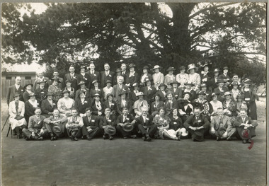
Photograph - Back to Cheltenham State School - A memento 28.11.1936, 1936
A reunion gathering for past students of Cheltenham State School held in November 1936A black and white photograph of a large group of men and women in a semicircle on a school play yard beside a weatherboard building .They all appear to be smartly dressed, many women wearing hats and the men in suits. Cheltenham School Reunion. The third annual "Back to Cheltenham State school" reunion attracted an attendance of 600 former scholars to the school on Saturday afternoon. The proceedings were opened by tho mayor of Moorabbin (Cr. J. W. Allnut). The oldest teacher present was Mrs. Grant, of Sorrento, who, as Miss Fraser, had charge of the school from 1880 to 1883. Another old identity was Mr. T. Evans, of Kew, who is 82 years of age — he was the head teacher from 1802 to 1800. Photographs were taken of Mrs. Grant with fifteen of her former pupils, and of Mr. Evans, who mustered 72 of his old scholars. The roll call showed that there were 50 pupils present who attended tho school more than half a century ago. Mrs. Buckley, of Mentone, who is 84, and Mr. W. P. Fairlam, of Cheltenham, 80 years, were the oldest former scholars in attendance. Mr. Fairlam, notwithstanding his age, still carries on the business of an auctioneer. Bouquets were presented to Mrs. Grant and Mrs Buckley by the president of the mothers' club (Mrs. Marshall). An enjoyable day was wound up by a dance at night in the mechanical institute, when 200 attended. (Age, Monday 30 November 1936, page 5)cheltenham primary school, state school, charman road, cheltenham, school, charman stephen, gettens mary, spring grove, balcombe road, nepean road, dairy farmers, market agrdeners, poultry farmers, methodist church, cancel, 1936 -
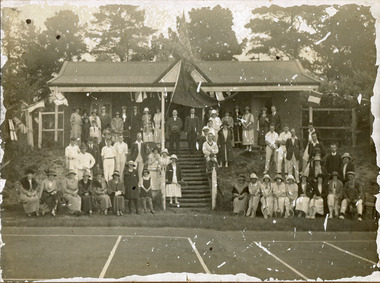 City of Moorabbin Historical Society (Operating the Box Cottage Museum)
Photograph, black & white Cheltenham Tennis Club 1920, and 2 Documents, 1920
Cheltenham Tennis Club was established 1883 when Shire of Moorabbin released land in Cheltenham Park for recreational use. 1924 The Shire of Moorabbin gave permission for the development of extra Courts.Cheltenham Tennis Club 1883 was one of the first Tennis Clubs established in Melbourne.A black and white photograph of men and women seated and standing in and around the Cheltenham Tennis Clubhouse in Cheltenham Park, Cheltenham in 1920. Letter Handwritten 1883 Shire of Moorabbin, South Brighton , release of land in Cheltenham Park for the development of Tennis Courts. Letter Typed 1924 Shire of Moorabbin, permission for extra Courts, signed by the shire secretary, Alexander Chalmers Smith.PHOTO ; written on back : Cheltenham Tennis Club 1920 / Cheltenham Park Letter ; signed John Keys Shire of Moorabbin South Brighton Logo 1871 Letter ; Shire of Moorabbin Logo 1924charman road, cheltenham, 1920, tennis club. charman stephen, gettens mary, spring grove, charman road, balcombe road, nepean road, dairy farmers, market agrdeners, poultry farmers, methodist church, keys john, shire of moorabbin, colsamix, cheltenham park melbourne, sabbath victorian law article 26, cheltenham golf club -
 City of Moorabbin Historical Society (Operating the Box Cottage Museum)
Photograph, 1936 Back to Cheltenham State School, 1936 Back to Cheltenham State School, 1936
1936. Back to Cheltenham State School, Charman Road, Cheltenham. Photograph is black and white. Four rows of men and women dressed in their best clothes. School photo of coming back to Cheltenham in 1936. The men are wearing suits, some with waistcoats, and white shirts with neckties. The women are wearing dresses some with jackets,. On every man and women, they have a sticker against their chest with their names on it. Most of the ladies are wearing hats on their head, and about four ladies have their hats on their lap. The front row are sitting on the ground, second row sitting on a chair and third and fourth rows are standing.Front of Mount : Back to Cheltenham 1936 / CHARMAN RD. SCHOOL Stamp on back of Mount : N. R. McGeehan. / 154 / Hotham St / Ripponlea / Photographer.state school, charman road, cheltenham, 1936, school, cheltenham primary school, charman stephen, gettens mary, spring grove, balcombe road, nepean road, dairy farmers, market agrdeners, poultry farmers, methodist church -
 City of Moorabbin Historical Society (Operating the Box Cottage Museum)
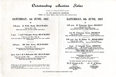
Flyer - Outstanding Auction Sales, 1957
Sale of property of the estate of Charles McCarthy Stott, a local estate agent. Example of the progress of the Municipality of MoorabbinAdvertising flyer for outstanding Auction Sales in the estate of Charles McCarthy Stott (1870-1956).Saturday 1 June 1957 - 4 properties for sale in Beaumaris - Saturday 8 June 1957 - 4 properties for sale in Highett (x2), Moorabbin, Ormondormond, 33 wells road beaumaris, 7 & 9 douglas street beaumaris, 100 oak street beaumaris, 5 & 6 balcombe road beaumaris, 34 tennyson street highett, 13 leopold st ormond, lot 93 tennyson street highett, lot 52 delma st moorabbin, auction, real estate