Showing 121 items matching "basalt"
-
 Brimbank City Council Art Collection
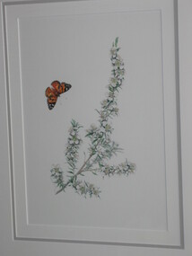
Painting (Watercolour), Helene Wild, Woolly Tea-Tree, 1994
Local Indigenous PlantWatercolour painting - Indigenous Plants of the Basalt Plains. Part of series of 14 commissioned paintings.Details of the plant on the back of the painting -
 Kiewa Valley Historical Society
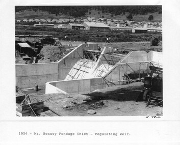
Photograph - Folder of Photographs – Photocopied set of 10 black and white photographs (pages 29 - 38) from the display folder put together by KVHS to document life on the Kiewa Valley Hydro-electric Scheme
Although the Kiewa Hydro-Electric Scheme was first proposed in 1911, construction did not commence until 1938. As part of the push to cut electricity costs and diversify supply, the Victorian Government (circa 1930) initiated the conversion from primarily brown coal supply to hydro – electricity. Field investigations during the 1940’s resulted in a new proposal for a scheme that had more than double the capacity of the 1938 scheme. The Kiewa Hydroelectric Scheme became the largest scheme of its kind in the State Of Victoria and the second largest scheme in Australia. The number of personnel involved in the planning and construction of the scheme increased dramatically. During the late 1940’s, most activity centred around the construction of the West Kiewa Power Station, Rocky Valley Reservoir, McKay Creek Power Station and the Bogong Creek Aqueduct.A common thread across all the larger hydro scheme constructions was the need for workers, both qualified and unqualified who came from around the world seeking a new life for themselves and their families. New accommodation and facilities were required for the army of workers engaged in construction in often remote and wild areas. The SEC had a high demand for timber, and set up the first of a number of sawmills at Bogong Creek in 1939 and set up the first hardwood logging in the headwaters of the Kiewa River. These new ‘towns’ such as Mt Beauty and Bogong, survived, serving the needs of operational personnel and their families, and expanding with growth of new industries. Mount Beauty, and to a lesser extent Bogong, are among these places. Large A3 size spiral bound display folder containing 21 pages of photocopied black and white photographs of various aspects of the early days of the Kiewa Valley Hydro-electric scheme including equipment, various work sites and photographs of workers and their families. 1-Mt Beauty Pondage inlet-Regulating weir 2-Langfords Gap Basalt Hill-Tunnel in quarry face.3-Rocky Valley Camp-from Engineering Office 4-Basalt Hill tunnel portal 5-No 1 Pressure Shaft Works Bench 6-No 1 Power Station 7-Overturned haulage wagons on the side of an embankment 8- Group of workers dressed in wet weather gear inside a tunnel 9-Workmen and vehicle in tunnel 10-Howman’s Gap campsite at 4,150 feet 1-1954 – Mt Beauty Pondage inlet – Regulating weir Page number 29 2-28/10/54 – Langfords Gap Basalt Hill – Tunnel in quarry face K7860 Page number 30 3-STATE ELECTRICITY COMMISSION OF VICTORIA Date: 17.8.55 Time: No K8132 Kiewa Hydro Electric Works ROCKY VALLEY CAMP – FROM ENGINEERING OFFICE Page number 31 4-28/10/54 – Basalt Hill tunnel portal K7859 Page number 32 5-No.1 Pressure Shaft Works Bench 5.7.56 Page number 33 6- No. 1 Power Station 26.4.59 Page number 34 7- No markings Page number 35 8-No markings (Wooden board on ground printed with - POLAR A.N.GELATINE DYNAMITE “75” DE 28.8.40) Page number 36 9-No markings Page number 37 10-Howman’s Gap campsite at 4,150 feet Page number 38 secv; kiewa hydro electric scheme; mt beauty; bogong; construction area -
 Bendigo Historical Society Inc.
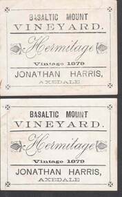
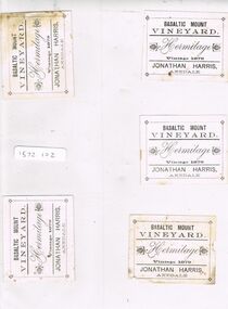
Document - HARRIS COLLECTION: WINE LABELS FOR BASALTIC MOUNT VINEYARD
Wine Labels - Basaltic Mount Vineyard, Two labels for Hermitage wine, vintage 1879. Jonathan Harris Axedale.person, individual, harris -
 Stawell Historical Society Inc
Photograph, Junction Hotel - Armstong
Colour Photograph: The remains of Junction Hotel residue of mortar etc. also basalt slabs from lintels and door steps.junction hotel, fountainhead brewery -
 Federation University Historical Collection
Document, C.E. Hounam et al, Commonwealth of Australia Bureau of Meteorology - Climate of the Basaltic Plains of Western Victoria, 1963
Brown cardboard covered foolscap sized typed document with diagrams Handwritten on front. Symposium - Royal Society of Victoria "Basaltic Plains of Victoria" 12 September 1963basaltic plains of victoria, royal society of victoria, commonwealth of australia bureau of meteorology, c.e. hounam, f.a. powell, symposium, maps -
 Hume City Civic Collection
Photograph, Early 1990's
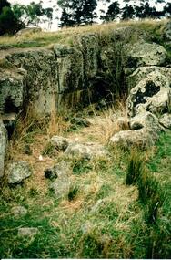
This is a photograph of one of the many stone ruins which can be seen in the Sunbury area and surrounding districts. These ruins are found in varying degrees of structural damage caused by erosion, vegetation growth and vandalism. This is the remains of a bluestone quarry on the 'Oaklands' property at Oaklands Junction.A coloured photograph in portrait format of a basalt rock ruined structure which has been dug into a hillside with a line of trees in the background.stone structures, oaklands quarry, george evans collection -
 Ballarat Heritage Services
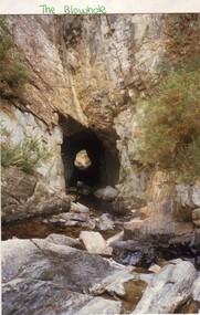
Photograph - Photograph - Colour, L.J. Gervasoni, Blowhole, Hepburn Springs, 1987, 1987
Colour photograph of a view through a blast hole made through basalt at Hepburn by Chinese Miners to divert the Jim Crow Creek.blowhole, hepburn, chinese, jim crow creek -
Ringwood and District Historical Society
Rocks - Minerals, Two rocks from Ringwood Antimony Mine c 1900, c. 1900
Two rocks showing quartz, basalt and stibnite. Some yellowing due to oxides of antimony from the Ringwood antimony mine. No traces of gold however! -
 Bendigo Historical Society Inc.
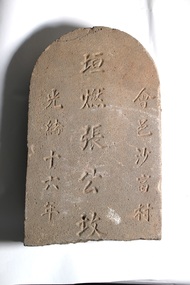
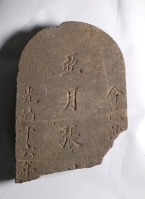
Decorative object - CHINESE GRAVESTONE
Chinese Gravestone -Broken. This is a piece of a Chinese Gravestone from what appears to be a form of Basalt. Contains several Chinese characters. Also, includes a translation. chinese gravestone, bendigo -
 Bendigo Historical Society Inc.
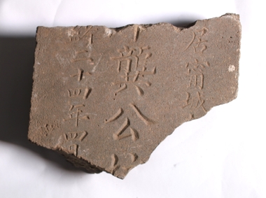
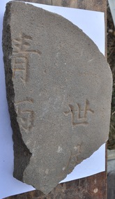
Decorative object - CHINESE GRAVESTONE
Chinese Gravestone -Broken. This is a piece of a Chinese Gravestone from what appears to be a form of Basalt. Contains several Chinese characters. Also, includes a translation. chinese gravestone, bendigo -
 Bendigo Historical Society Inc.
Decorative object - CHINESE GRAVESTONE
Chinese Gravestone -Broken. This is a piece of a Chinese Gravestone from what appears to be a form of Basalt. Contains several Chinese characters. Also, includes a translation. chinese gravestone, bendigo -
 Bendigo Historical Society Inc.
Decorative object - CHINESE GRAVESTONE
Chinese Gravestone - Broken. This is a piece of a Chinese Gravestone from what appears to be a form of Basalt. Contains several Chinese characters. Also includes a translation.chinese gravestone, bendigo -
 Bendigo Historical Society Inc.
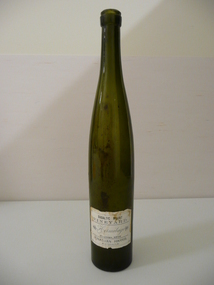
Container - AXEDALE WINE BOTTLE, 1879
Green glass wine bottle with white paper label with black print reading, Basaltic Mount Vineyard. Heritage Vintage 1879 Jonathan Harris, Axedale.organisation, industry, vineyard -
 Bunjil Park Aboriginal Education & Cultural Centre
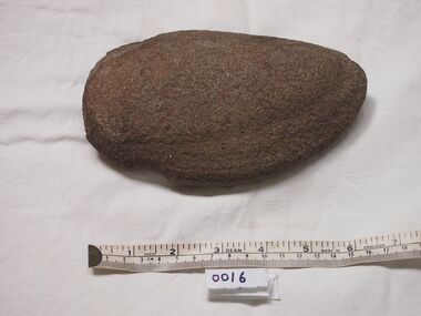
Basalt Digging Stone
.This stone was attached to a handle and possibly used to collect yabbies and shellfish from water holesA Basalt digging stone with a blunted edge shaped to a smooth curve. One side is flat and trhe other is convex. This item has 1 groove at the wide end for attaching a handle.basalt digging stone, jarra, aboriginal stone tools, -
 Federation University Historical Collection
Photograph - Photograph - Digital, Geoff Little, Ballarat Gaol Under Demolition, 1968, 1968
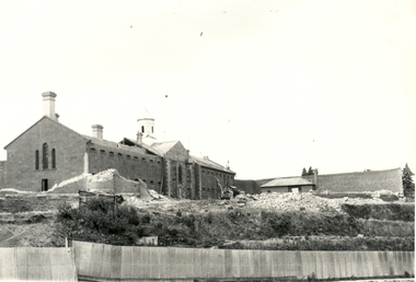
The Ballarat Gaol was one of the earliest gaols. Building commenced in 1856 and was completed in 1862. It provided accommodation for 74 prisoners - male and female. The materials use to build the gaol were locally quarried basalt combined with local bricks. At that time there were about 14 brick making plants in Ballarat. 1870 saw the opening of the School of Mines, Australia's third oldest tertiary institution. The purpose of the school was "to impart instruction in the various branches of science relating to mining engineering. It is proposed, as soon as practicable, to extend the operation of the school so as to impart instruction in those branches of technical science which may be considered most likely to exert a beneficial influence on the prosperity of Victoria." School was in a disused Circuit Court House in Lydiard Street South. Sir Redmond Barry was first President of the School of Mines Council.Seven black and white and sepia photographs of the Ballarat Gaol under demolition. Progressive demolition showing rubble and machinery used. Gift of photographer. ballarat gaol, ballarat school of mines, gaol, basalt, local bricks, prisoners, circuit court house, mining engineering, sir redmond barry, lydiard street, tertiary institution, geoff little -
 8th/13th Victorian Mounted Rifles Regimental Collection
Photograph
In 1988, as part of a Defence of Mainland Australian policy, defence of facilities of strategic importance in northern Australia were allocated to Army Reserve units. ‘A’ Squadron was allocated the defence of Tindal Air Force base located 15 KM outside Katherine in Northern Territory. Consequently the Squadron deployed on Exercise ‘Northern Explorer’ to gain first-hand knowledge of operating conditions for mounted and dismounted patrolling in the area.Colour photograph of jaggered basalt rock covering most of high country SSW of Tindal RAAF Base, Northern Territory. Photo was taken to illustrate reports of patrols during Exercise " Northern Explorer" September 1988. -
 Coal Creek Community Park & Museum
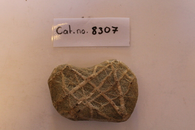
Criss-crossed piece of bluestone/basalt
8307.1 - 'Rounded rectangle' shaped piece of highly weathered bluestone/basalt. Yellowish-green; criss-crossed by prominent white veins of secondary quartz mineralisation. 'Bandage' bearing the words "miss Western" stuck on one side.- miss Western -
 Hume City Civic Collection
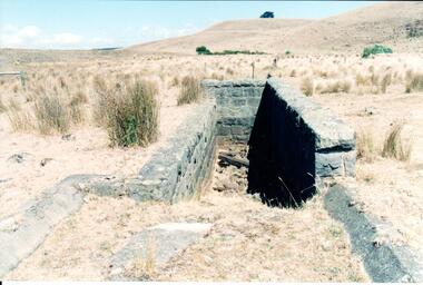
Photograph, Early 1990's
This is a photograph of one of the many stone ruins which can be seen in the Sunbury area and surrounding districts. These ruins are found in varying degrees of structural damage caused by erosion, vegetation growth and vandalism. The bluestone structure was a sheep dip on the 'Karoora Park' property near Jacksons Creek.A coloured photograph of the stone remains of a sheep dip constructed from basalt rock. The ground at the entrance slopes down into a narrow walled channel. The surrounding paddocks are covered with tussocks of grass and there are bare hills in the background. The grass is brown.stone structures, sheep dips, basalt rock, 'karoora park', george evans collection -
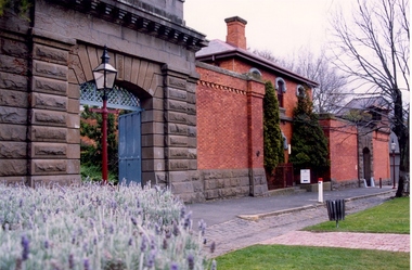 Federation University Historical Collection
Photograph - Photograph - Colour, Former Ballarat Gaol Gates and Warden's Quarters, 2001, 1991
The Ballarat Gaol operated between 1862 and 1965. The complex was based on a central hall from which radiated wings of cells. This meant one guard could stand in the centre of the hall and see all the cells. Most of the gaol was demolished to allow the School of MInes Ballarat to expand. The remaining structures at the site include the main gate, the Warden's Residence, shown in the photo, and the Governor's Residence. These buildings are now used by Federation University. The Warden's Residence is home to the Australian Centre for Research into Injury in Sports and its Prevention.Colour photograph of the main gate of the former Ballarat Gaol and the Warden's Quarters. The gate features a beautifully executed arch keystone of basalt and appears to be cut from one single block of stone. The two storey Warden's Quarters are to the right of the gates.ballarat gaol, lydiard street south, ballarat school of mines, cells, guard, warden's residence, governor's residence, federation university -
 Bendigo Historical Society Inc.
Ephemera - HARRIS COLLECTION: WINE LABELS
BHS Collection5 wine labels. Basaltic Mount Vineyard - Hermitage vintage 1879 - Jonathan Harris, Axedale. The labels are printed on white paper in black ink, the only design is of two bunches of grapes at either side of the word Hermitage. The labels are in a plastic folder.ephemera, mementoes, wine label -
 Bendigo Historical Society Inc.
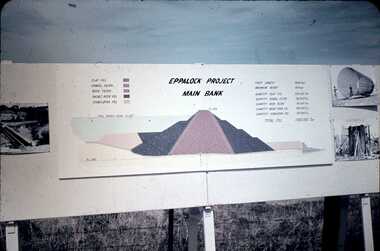
Slide - DAVID MCDONALD COLLECTION: EPPALOCK. CONSTRUCTION, c1960
Eppalock. Construction. Eppalock Project Main Bank. Lake consists of clay fill, Gravel Filter, Rock Filter, Basalt Filter, Stabilizing Fill. Full Supply Level RL637. Crest Length 2000 Feet, Maximum Height 150 Feet, Quantity Clay Fill 550 000 Ton, Quantity Gravel Filler 120000 Ton, Quantity Rock Filler 60 000 Ton, Quantity Basalt Rock Fill 250 000 Ton, Quantity Stabilizing Fill 150 000 Ton, Total Fill 1630 000 Ton. Markings: Eppalock Dam Observation Point Board.Agfacolorcivil engineering, water supply, eppalock -
 City of Ballarat
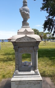
Artwork, other - Public Memorial, Ned Williams Memorial, 1901
Ned Williams was born in Bristol, England in 1825 and died at Ballarat 7 September 1900. Ned took a leading role in transforming what was a swamp (Yuille's Swamp) into the modern day Lake Wendouree. Ned was the establishment and promotion of water sports on the lake, he was well liked in the community and highly regarded as a leading citizen, an athlete, a sportsman and as an oarsman. This memorial was commissioned on his passing in 1900.The item is of aesthetic and historic significance to the people of BallaratA Carrara marble fountain on a basalt base. Eight tiers of marble, the central element is bordered by four pillars with decorative capitals on top. The pillars and capitals are secured with copper allot rod at the upper junction and ferrous rods at the base. Once had a working drinking fountain.Created by the friends of Edward King (Ned) Williams in commemoration of his qualities as a pioneer citizen, oarsman, athlete, and sportsman. Ned Williams Born at Bristol England November 4th 1825, Died at Ballarat September 7th 1900. His heart was kind and true. He took a leading part in transforming Wendouree, from a swampy waste into a picturesque lake and was ever foremost in establishing and promoting aquatic and other manly sports.ned williams ballarat, lake wendouree -
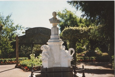 Friends of Ballarat Botanical Gardens History Group
Work on paper - The Restored F. M. Claxton Monument, The Re-opening of a Significant Memorial, 15th August, 1997
The Claxton Memorial consists of a white marble bust and pedestal set on a cement rendered base with pressed cement dolphins, the whole being set on a basalt plinth in a rendered brickwork pond surrounded by a wrought iron fence.The F.M. Claxton Memorial is a significant memorial structure and is of primary significance to the Ballarat Botanical Gardens. It is one of the relatively few sculptures which recognise the work and dedication of one of Ballarat's leading figures in the nineteenth century.A coloured gloss photograph of the F.M Claxton MonumentOn the back of the photograph in blue biro is written, "Claxton Monument and Fountain. Photo taken by R.M (R.Mosman, very likely) after extensive restoration work and reopening on 15.8.1997.john garner, doctor, frederick moses claxton, ballarat botanical gardens, claxton memorial, friends of the ballarat botanical gardens, lake wendouree, public subscription, restoration, jude schahinger, george seddon., claxton, john garner collection, gardens, ballarat -
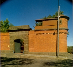 Federation University Historical Collection
Photograph - Photograph - Colour, Former Ballarat Gaol Gate and Tower, c2000
The gate shown in the photograph is located on the same wall as the large double main gate of the former Ballarat Gaol. Next to the gate is a watchtower with guard walk on top of the brick wall. This corner location provided the guards with a clear view into the gaol grounds and the street outside. Most of the gaol was demolished to allow for the School of Mines to expand. This watchtower remains along with the main gate, Warden's Quarters and the Governor's residence. These buildings are now used by Federation University Ballarat.Colour photograph of the former Ballarat Gaol Gate and watchtower taken c2000. Structure built from red brick and locally quarried basalt. Guards walk on top of wall from tower to gate was corrugated iron. This smaller gate was to the right of the Warden's Quarters on the same wall as the main double gates to the gaol.ballarat gaol, ballarat gaol gates, ballarat gaol watchtower, ballarat school of mines, federation university, warden's quarters, governor's residence, guard's walk, lydiard street south -
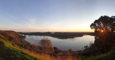 Ballarat Heritage Services
Photograph, Clare Gervasoni, Tower Hill Crater, 11/09/2020
Tower Hill is 18km west of Warrnambool and is accessed from the Princes Highway. Tower hill is a dormant volcano, with associated conical hills, large and small craters, basalt outcrops from lava flows and layers of Ash from long ago eruptions. Panorama of the crater at Tower Hilltower hill, crater, volcano -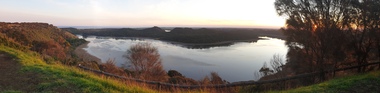
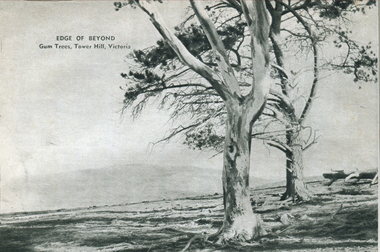 Ballarat Heritage Services
Photograph - Image - Black and White, Gum Trees on Tower Hill, Victoria, c1950, c1950
Tower Hill is 18km west of Warrnambool and is accessed from the Princes Highway. Tower hill is a dormant volcano, with associated conical hills, large and small craters, basalt outcrops from lava flows and layers of Ash from long ago eruptions. A black and white image of two trees in a barron landscape at tower Hill,Victoriagum trees, tower hill -
 Federation University Historical Collection
Map, Ballarat Goldfield, c1898
This map shows geological features, suggests the last basalt flow, and includes alotments and names of Mining Companies. Although this map has no date on it the Ballarat Industrial School is used for dating purposed. The Ballarat Industrial School ran from 1869-1879, but the term Ballarat Industrial School Reserve was still in use in 1898 and possibly beyond.Geological Map of Ballarat with 3 holes in the left hand side. The map indicates the position of Lake Wendouree, Township of Warrenheip, Ballarat East, Industrial School Reserve, Winters Swamp, Police Paddock, Wyndholm Premptive Right (Salton and Waldie), Black Hill, Vale Park Reserve, Pennyweight Hill, Little Bendigo, Black Swamp Lead, monte Christo Reef, Chinaman's Gully, Miners Rest, Pincotts Dam, Northumberland Gully. It also show the following goldmining companies: City of Ballarat, Kohinor, Hand and Band, Great North West, Northern Junction, Kneeshaw, Rossers Freehold, Silurial.ballarat, warrenheip, lake wendouree, ballarat east, winters swamp, winter swamp, wyndholm premptive right, cemetery, vale park reserve, little bendigo, kneeshaw co., industrial school reserve, kirks dam, pincotts dam, black hill, wombat hill, dead horse gully, miners rest, mt rowan, salton and waldie, rose hill co, great north west no 1, rose's freehold co, hand and band co, police reserve, police paddock, mount rowan, ballarat industrial school reserve, market reserve, winter's swamp, kneeshar co, monte cristo line of reef, chinaman's gully or black snake, milkmaid's gully, ballarat gold field, bakery hil lead, old gravel pits lead, golden point lead, eureka lead, miner's rest, yarrowee creek, leigh creek, black swamp lead, yorkshire reef, nil desperandum reef, cockatoo lead, hit or miss gully, herbert werner frederick de nully, pennyweight hill, esmond's lead, ash's lead, nightingale lead, john bull gully, gladstone reef, whitehorse reef, petticoat creek, pincott's dam, frenchman's gully, tim's crushing plant, jenkin's gully, california gully, drake's creek, sulton and waldie, ballarat undustrial school, ballarat & mariborough railway -
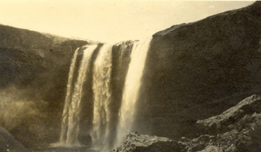 Federation University Historical Collection
Photograph, Wannan Falls near Hamilton
Wannon Falls were created by lava flows that surged upstream to the Wannon River. The cascade is a 30 metre vertical drop into a deep plunge pool. Downstream rapids wind their way around large blocks of basalt. The Wannon Falls have been painted by notable artists such as Nicholas Chevalier, Eugene von Guerard, Thomas Clark and Louis Buvelot.Black and white photograph of a waterfall cascade known as Wannon Falls.Verso in black ink handwriting 'Wannon Falls near Hamilton'chatham family archive, chatham, wannon falls, hamilton, waterfall -
 Federation University Historical Collection
Book, Memoirs of the Geological Survey of Victoria No 14 The Ballarat Goldfields, 1923, 1923
William Baragwanath was educated at the Ballarat School of Mines, obtaining a Geology Certificate in 1911. After further study he went on the become Secretary for Mines, and Chief Mining Surveyor. Baragwanath was a Councillor of the Ballarat School of Mine from 1916 to 1950.Pink covered foolscap book of 257 pages and 32 maps and plans by William Baragwanath. Contents include topography, physiography, historical, geology, basalt, faults, dykes, minerals leads, alluvial mines, nuggets, structure of Ballarat West goldfields, structure of Ballarat East gold-field, quartz formation, indicators, defunct mines, existing mines, table of deepest shafts. Images include: section of the Ballarat Gold-Field, Dead HOrse Flat, lakes formed by Basalt Flows, Gong Gong Creek, Frenchman's Lead, Ballarat West Mines, LEases and positions of shafts (1857), puddling, White Horse Lead, Woah Hawp Canton, Ballarat Township mines, Sebastopol, syncline, Victoria United Line, First Chance Mine, Llanberris No 1 Mine, Saddle Reef, New Normanby Mine, Woah Hawp Canton Mine, South Star Mine, Sebastopol Plateau, south Woah Hawp Mine, Woah No. 2 Minegeology, geological survey no 14, ballarat, baragwanath, william baragwanath