Showing 301 items matching "blue lake"
-
 Greensborough Historical Society
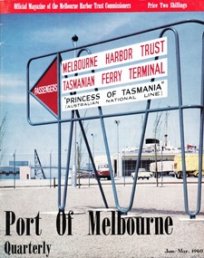
Article - Article, Journal, Melbourne Harbor Trust, "The Word is Progress": by Robin Hay, 1960_03
... called Blue Lake in Yellow Gum Park, Plenty...., was on the site now called Blue Lake in Yellow Gum Park, Plenty. reids ...The opening of Reid's Lightweight Aggregate Pty Ltd ( a subsidiary of Reid's Quarries Ltd) in Greensborough, circa 1960. Explains the method of manufacture and uses of shalite in building industry. Reid's later became Albion Reid before being taken over by Boral. The shalite quarry, now closed, was on the site now called Blue Lake in Yellow Gum Park, Plenty.7 photocopied pages, text and colour and black nd white illustrations.reids quarries, shalite, aggregate, yellow gum park, plenty -
 Ballarat Tramway Museum
Photograph - Colour Photograph/s, David Endacott, 1971
... On rear in blue ink "Lake Wendouree" and in top left hand... Aidans Drive On rear in blue ink "Lake Wendouree" and in top left ...Colour print of a Ballarat single trucker en route for the Gardens, just past St Aidans Drive during Winter 1971. Photo taken from partly within Lake Wendouree, looking at the tramcar through the trees, which has passed the photographer. See also Reg Nos. 1279 and 1280 for related images. On Kodak paper. Not the same tram as on 1279 or 1280 as it has a SEC and Eureka Tiles roof ad. Original film image scanned at 3200dpi 12/5/2020.On rear in blue ink "Lake Wendouree" and in top left hand corner "1971".ballarat, lake wendouree, st aidans drive -
 Ballarat Tramway Museum
Photograph - Colour Photograph/s, David Endacott, 1971
... On rear in blue ink "Lake Wendouree" and in top left hand... Aidans Drive tram 13 On rear in blue ink "Lake Wendouree ...Colour print of a Ballarat No. 13 en route for the Gardens, just past St Aidans Drive during Winter 1971. Photo taken from partly within Lake Wendouree, looking at the tramcar through the trees, which has passed the photographer. See also Reg Nos. 1278 and 1280 for related images. On Kodak paper. Would appear to be the same trams as in 1280 as it does not have a roof advertisement. Original film image scanned at 3200dpi 12/5/2020.On rear in blue ink "Lake Wendouree" and in top left hand corner "1971".ballarat, lake wendouree, st aidans drive, tram 13 -
 Ballarat Tramway Museum
Photograph - Colour Photograph/s, David Endacott, 1971
... On rear in blue ink "Lake Wendouree" and in top left hand... Aidans Drive tram 13 On rear in blue ink "Lake Wendouree ...Colour print of a Ballarat No. 13 en route for the Gardens, just past St Aidans Drive during the winter of 1971. Photo taken from partly within Lake Wendouree, looking at the tramcar through the trees, before it has passed the photographer. See also Reg Nos. 1278 and 1279 for related images. On Kodak paper. Tram has a Twin Lakes advertisement on the front dash panel. Homes along St. Aidans drive can be seen in the background. Original film image scanned at 3200dpi 12/5/2020.On rear in blue ink "Lake Wendouree" and in top left hand corner "1971".ballarat, lake wendouree, st aidans drive, tram 13 -
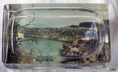 Flagstaff Hill Maritime Museum and Village
Ash Tray
... of Blue Lake, Mount Gambier on base. Donated by Mrs G Angus, 309B..., rectanglar, moulded glass with coloured photo of Blue Lake, Mount ...Ash tray, rectanglar, moulded glass with coloured photo of Blue Lake, Mount Gambier on base. Donated by Mrs G Angus, 309B Koroit St, W'bool 27 Feb 1979.flagstaff hill, warrnambool, shipwrecked-coast, flagstaff-hill, flagstaff-hill-maritime-museum, maritime-museum, shipwreck-coast, flagstaff-hill-maritime-village -
 Port Melbourne Historical & Preservation Society
Audio - PMHPS Meeting, David Sornig, Dudley Flats, Garry Smart, 29 Apr 2019
... David Sornig talks about his book"Blue Lake: Finding Dudley... his book"Blue Lake: Finding Dudley Flats and the West ...David Sornig talks about his book"Blue Lake: Finding Dudley Flats and the West Melbourne Swamp" Duration1:15:08 (including meeting preliminaries) PMHPS Meeting 29/4/2019natural environment, dudley flat -
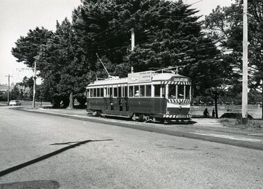 Ballarat Tramway Museum
Photograph - Black & White Photograph/s, 4/04/1969 12:00:00 AM
... In blue ink, "Lake Wendouree (near Haddon St), No. 36, 4-4... Haddon St Wendouree Parade tram 36 In blue ink, "Lake Wendouree ...Yields information about the operation of trams in Ballarat and Lake Wendouree.Black and white photograph of No. 36, Wendouree Parade, near Haddon St, 4/4/1969. Tram has the destination of Gardens via Drummond St. Nth and SEC Roof advertisement. Shows lake in the background.In blue ink, "Lake Wendouree (near Haddon St), No. 36, 4-4-69"tramways, trams, haddon st, wendouree parade, tram 36 -
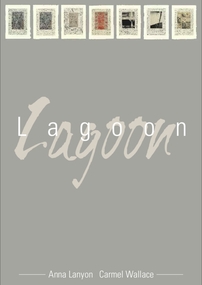 Glenelg Shire Council Cultural Collection
Mixed media - Framed Art Work, Wallace, Carmel et al, Lagoon, 2004
... : Etching with chine collé Paper: Blue Lake (Australia) 100% cotton... 2004 Medium: Etching with chine collé Paper: Blue Lake ...© Anna Lanyon , Carmel Wallace 2004. Apart from any fair dealing for the purposes of private study, research, criticism or review permitted under the Copyright Act, no text, image or part thereof may be reproduced, stored in a retrieval system, or transmitted in any form, without prior written permission from the authors.This suite of etchings explores the natural and social history of Fawthrop Lagoon, an ancient intertidal lagoon that lies at the heart of Portland on the far south-west coast of Victoria, Australia. The work records and interprets essential moments in the life of the lagoon, the plants, birds, insects, water-creatures and humans who have lived and continue to live around its shores. A suite of seven mixed media artworks each piece framed. Each piece is unique and is labelled as A/P (Artists Proof) Text: Anna Lanyon Images: Original etchings printed by Carmel Wallace at Portland Bay Press Victoria Australia 2004 Medium: Etching with chine collé Paper: Blue Lake (Australia) 100% cotton rag 600gsmfawthrop lagoon, portland, victoria, australia, plants, birds, insects, water, creatures, humans -
Glenelg Shire Council Cultural Collection
Souvenir - Wooden Shield, n.d
... - Blue Lake Ladies 1967 - Warrnabool and District 1961... 1966 - Naracoorte H.P.B 1960 - Horsham Pipeband 1963 - Blue ...Portland Highland Pipe BandWooden shield with 8 shield shaped silver plaques and one oval plaque, arranged around a central larger oval plaque. This larger plaque is decorated on the outside with a silver wreath hang top of shield is a silver banner. Inscriptions a banner,and all plaques. Two hooks with string to hang, on back.Front: Banner - 'Portland annual street march Highland gathering' Central Plaque: J.G Murrell Memorial Shield 1959 Other plaques: 1959 - Portland Highland Pipeband 1962 - Portland Ladies H.P.B 1966 - Naracoorte H.P.B 1960 - Horsham Pipeband 1963 - Blue Lake Ladies 1967 - Warrnabool and District 1961 - Naracoorte Highland Pipeband 1964 - Portland H.P.B 1968 - Portland H.P.Bportland highland band, memorial shield, 1959, music -
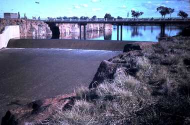 Bendigo Historical Society Inc.
Slide - DAVID MCDONALD COLLECTION: EPPALOCK. CONSTRUCTION, c1963
... Eppalock. Construction. Picture of the blue water in Lake.... Construction. Picture of the blue water in Lake Eppalock, the road ...Eppalock. Construction. Picture of the blue water in Lake Eppalock, the road going over the spillway and the water going over the spillway.Agfacolorcivil engineering, water supply, eppalock -
 Lakes Entrance Historical Society
Photograph - Harbeck/Newman, 1970
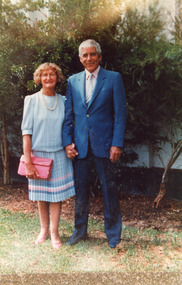
... on their wedding day. Jessie in pale blue ensemble, pink toned handbag... shirt and pale blue tie. Lakes Entrance Victoria Photograph ...Colour photograph of David and Jessie Newman Harbeck on their wedding day. Jessie in pale blue ensemble, pink toned handbag and shoes, David in dark blue suit, white shirt and pale blue tie. Lakes Entrance Victoriagenealogy, celebration -
 Lakes Entrance Historical Society
Photograph - M V Blue Bird, Bulmer, 25/11/1955 12:00:00 AM
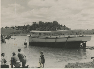
... Black and white photograph of Peels ferry M V Blue Bird... and white photograph of Peels ferry M V Blue Bird north Arm Lakes ...Written information and photocopies of newspaper articles included with catalogue sheetBlack and white photograph of Peels ferry M V Blue Bird north Arm Lakes Entrance boats and boating, tourism -
 Eltham District Historical Society Inc
Photograph - Digital Photograph, Marguerite Marshall, Stuchbery Farm dairy, 14 March 2008
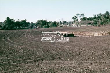
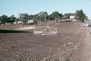
... Area includes the Blue Lake, coloured turquoise at certain... Area includes the Blue Lake, coloured turquoise at certain ...Stuchbery Farm was situated on the Plenty River bounded by Smugglers Gully to the north and La trobe Road, Yarrambat, to the east. Alan and Ada Stutchbery moved to the valley in 1890, first living in a tent where four children were born. Alfred built a home and outbuildings around 1896. They planted an orchard, then a market garden and developed a dairy. Published: Nillumbik Now and Then / Marguerite Marshall 2008; photographs Alan King with Marguerite Marshall.; p179 The dramatic steep-sided Plenty Gorge lies along the divide of two geological areas, and separates the Nillumbik Shire and the City of Whittlesea. On the Nillumbik side are undulating hills and sedimentary rock, and in Whittlesea, lies a basalt plain formed by volcanic action up to two million years ago. This provides the Plenty Gorge Park with diverse vegetation and habitats, making it one of Greater Melbourne’s most important refuges for threatened and significant species. The park, established in 1986, consists of around 1350 hectares, and extends 11 kilometres along the Plenty River, from Greensborough to Mernda. It provides a wildlife corridor for around 500 native plant and 280 animal species. The area’s plentiful food and water attracted the Wurundjeri Aboriginal people and then European settlers. By 1837 squatters had claimed large runs of land for their sheep and cattle. The Plenty Valley was among the first in the Port Phillip District to be settled - mainly in the less heavily timbered west - and was proclaimed a settled district in 1841. But by the late 1880s, the settlers’ extensive land clearing for animal grazing, then agriculture, depleted the Wurundjeri’s traditional food sources, which helped to drive them away. Many Wurundjeri artefacts remain (now government protected), and so far 57 sites have been identified in the park, including scarred trees, burial areas and stone artefacts. Pioneer life could be very hard because of isolation, flooding, bushfires and bushrangers. Following the Black Thursday bushfires of 1851, basalt was quarried to build more fire-resistant homes. Gold discoveries in the early 1850s swelled the population, particularly around Smugglers Gully; but food production made more of an impact. In the late 1850s wheat production supplanted grazing. In the 1860s the government made small holdings available to poorer settlers. These had the greatest effect on the district, particularly in Doreen and Yarrambat, where orchards were established from the 1880s to 1914. Links with a prominent early family are the remains of Stuchbery Farm, by the river’s edge bounded by Smugglers Gully to the north and La Trobe Road, Yarrambat, to the east. The Stuchberys moved to the valley in 1890, and the family still lives in the area. In 1890, Alfred and Ada first lived in a tent where four children were born, then Alfred built the house and outbuildings around 1896. They planted an orchard, then a market garden, and developed a dairy. The family belonged to the local Methodist and tennis communities. Their grandson Walter, opened the Flying Scotsman Model Railway Museum in Yarrambat, which his widow, Vi, continues to run. Wal was also the Yarrambat CFA Captain for 22 years until 1987. Walter sold 24 hectares in 1976 for development - now Vista Court - and in 1990, the remaining 22.6 hectares for the park. Remaining are an early stone dairy and remnants of a stone barn, a pig sty and a well. Until it was destroyed by fire in 2003, a slab hut stood on the Happy Hollow Farm site, at the southern end of the park. The hut is thought to have been built in the Depression around 1893. This was a rare and late example of a slab hut with a domestic orchard close to Melbourne. Emmet Watmough and his family first occupied the hut, followed by a succession of families, until the Bell family bought it around 1948. There they led a subsistence lifestyle for 50 years, despite encroaching Melbourne suburbia. The Yellow Gum Recreation Area includes the Blue Lake, coloured turquoise at certain times of the year. Following the 1957 bushfires, this area was quarried by Reid Quarries Pty Ltd for Melbourne’s first skyscrapers, then by Boral Australia. However in the early 1970s water began seeping into the quarry forming the Blue Lake and the quarry was closed. The State Government bought the site in 1997 and opened it as a park in 1999.This collection of almost 130 photos about places and people within the Shire of Nillumbik, an urban and rural municipality in Melbourne's north, contributes to an understanding of the history of the Shire. Published in 2008 immediately prior to the Black Saturday bushfires of February 7, 2009, it documents sites that were impacted, and in some cases destroyed by the fires. It includes photographs taken especially for the publication, creating a unique time capsule representing the Shire in the early 21st century. It remains the most recent comprehenesive publication devoted to the Shire's history connecting local residents to the past. nillumbik now and then (marshall-king) collection, ada stuchbery, alan stuchbery, dairy, stuchbery farm, farm buildings, yarrambat, plenty gorge park -
 Ballarat Heritage Services
Photograph - Image, Mrs Stephen Henty of Portland
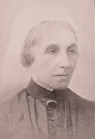
... of the Blue Lake at Mt. Gambier. He said he would never forget... of the Blue Lake at Mt. Gambier. He said he would never forget ...Stephen Henty married Jane Pace in Fremantle April 1836; four sons and six daughters were the issue of the marriage. Mrs. Stephen Henty was born in Yorkshire on 14 April 1812, and she died in Hamilton on 02 February 1906. She was the first white woman to settle permanently in Western Victoria, arriving in Portland on 18 December 1836. From a small booklet "Old Memories," written by Jane Henty on her 84th birthday. 'My husband and I arrived at Portland Bay in 1836, though he had made some trips there previously. It was on a Sunday night we landed by moonlight. I was carried on shore through the surf by a sailor. On reaching the homestead, a comfortable dwelling composed of four rooms, kitchen and dairy, a bright log fire was burning, table spread with a large pot loaf, piles of eggs and tea. Edward had not travelled inland, but my husband never rested until he had gone all through the interior, cut a track through 15 miles of forest land with two men and a dray, and arrived on the banks of the Wannon. He used to be absent for weeks at a time, causing me great anxiety. The natives were not to be trusted, so he usually took with him an expiree from Tasmania. Stephen Henty fixed all three of the first stations -Muntham, Merino Downs, and Sandford. In July 1837 Stephen sent some fine flocks of merino sheep to Muntham, having previously had a hut built for the men, and yards for the sheep; his two brothers, John and Frank, took charge of the sheep on the road. "On August 3, 1837, my son Richmond was born the very day the sheep arrived at Muntham. Edward was in Tasmania at the time, and arrived three weeks after the birth of my son, with his brother James and his son... My husband and Edward were in partnership, Edward managing Muntham, and Stephen the mercantile part at Portland Bay. John managed Sandford and Frank Merino Downs... My husband was the first white man who stood on the border of the Blue Lake at Mt. Gambier. He said he would never forget the feeling of awe he felt on coming suddenly on the blue water in the wilderness.("The Portland Bay Settlement", by Noel Learmonth, 1934)Black and white image Mrs Stephen Henty.stephen henty, portland, pioneer, women, jane henty, jane pace, merino downs -
 Bendigo Historical Society Inc.
Photograph - FORTUNA COLLECTION: LAKE BY FORTUNA
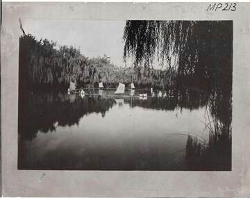
... ink. Written in blue ink 'Main Lake at Fortuna'. History... ink. Written in blue ink 'Main Lake at Fortuna'. History ...Black and white photograph showing lake by 'Fortuna'. The mansion owned by Ballestredt and later, Lansell families. View shows willowed margins and wind-driven construction on lake surface. Inscriptions: Top RH corner face of mount. MP 213. Stamped in circle on back: 'Historical Society of Victoria, Bendigo Branch'. Top RH corner on back 'MP 213' printed in clack ink. Written in blue ink 'Main Lake at Fortuna'. History of object: Previous Acc. No. 'MP 213'.cottage, miners -
Southern Sherbrooke Historical Society Inc.
Council Ephemera - Shire of Sherbrooke, 1990s
... sheet, blue, Emerald Lake waterslide, with two complimentary... sheet, blue, Emerald Lake waterslide, with two complimentary ...Folder containing various pamphlets, etc. issued by Shire of Sherbrooke. Contents: -card 14x8cm, With the compliments of the Shire of Sherbrooke -card 14x8cm, You were absent when I called -bifold card 15.5x10cm, with print of painting on front, "Celebrating the Dandenongs" Neil Douglas 1990, artwork, and Shire logo on back, in plain envelope -trifold pamphlet, Monbulk Aquatic Centre Redevelopment Information -trifold pamphlet, An introduction to environmental & noxious weeds in Sherbrooke -trifold pamphlet, A responsible approach to dog ownership in Sherbrooke, stamped Rod Bezanovic, Ranger, Conservation and recreation -trifold pamphlet, A guide to Sherbrooke's animal welfare local law -trifold pamphlet, Community services in Sherbrooke -trifold pamphlet, Local law, Balancing the needs of native and domestic animals in Sherbrooke -trifold pamphlet, Litter -trifold pamphlet, Local law No 6 open air burning and incinerator use -trifold pamphlet, Garden plants are going bush...and becoming environmental weeds!/--trifold pamphlet, Local law No 6 open air burning and incinerator use -trifold pamphlet, Minimising waste -trifold pamphlet, Local law No 6 open air burning and incinerator use -trifold pamphlet, Our services at a glance -trifold pamphlet, Local law No 6 open air burning and incinerator use -trifold pamphlet, Putting up signs on roadsides, parks or reserves in Sherbrooke -trifold pamphlet, Local law No 6 open air burning and incinerator use -trifold pamphlet, Customer Feedback -bifold pamphlet, Discover Emerald Lake Park -sheet of 28 round stickers featuring Shire logo and "Shire of Sherbrooke Glenfern Road, Upwey" -A4 sheet, blue, Emerald Lake waterslide, with two complimentary ride tickets stapled to it -A4 sheet, red, listing Fire Hazard clearance contractors 1994/5shire of sherbrooke, resident information, bylaws -
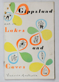 Orbost & District Historical Society
book, Victorian Railways Public Relations and Betterment Board ; Tourist Development Authority, Gippsland and its Lakes and Caves Victoria Australia, November 1954
Chairman of the Victorian Railways, Harold Clapp, established The Victorian Railways Public Relations and Betterment Board as part of a campaign to launch the Spirit of Progress – the first new train constructed during the Depression era. Clapp was an aggressive Chairman of Railway Commissioners who was determined to keep Victorian Railways prospering. This book was a promotion book for "The Gippslander". The Gippslander name has been used for trains in the Bairnsdale corridor since 1954This book is a useful research tool.A 28 pp paper back book, titled Gippsland and its Lakes and Caves Victoria Australia. The front cover has orange and black print with yellow, green and blue motifs on a white and yellow background. The book has a stapled spine. It contains a short description of each of Gippsland's towns, a centre, double page maap of the region and many b/w photographs.railway-transport gippsland clapp-harold -
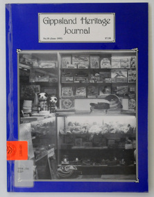 Orbost & District Historical Society
journals, Gippsland Heritage Journal, June 1995
This issue was edited by Meredith Fletcher. This magazine is a useful reference on the history of East Gippsland. A plastic-covered ,64 pp magazine, titled, Gippsland Heritage Journal. It has a dark blue cover with a b/w photograph of a shop at Lakes Entrance, East Gippsland. The shop is Bulmers Gift Salon. The cost of the journal is $7.50. It contains photographs and article on the history of East Gippsland.gippsland-heritage-journal history-east-gippsland history-lakes-entrance -
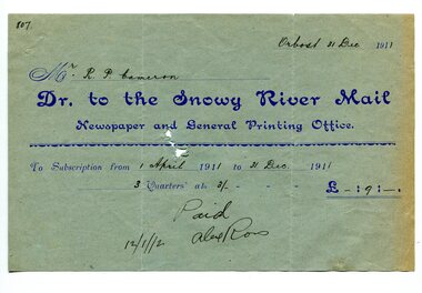 Orbost & District Historical Society
account, 12.12.1912
Previously published as The Snowy River mail and Tambo and Croajingolong gazette from 1890 to 1911. The Gippsland Courier merged with the Snowy River Mail when proprietor Lachlan Ross moved to Orbost in 1910. In 1999 the paper was acquired by the Yeates family when the Hollins family retired from the newspapers business. The paper is still being produced by the fourth generation of the Yeates family as part of East Gippsland Newspapers. They also produce the Bairnsdale Advertiser, the East Gippsland News and the Lakes Post and the yearly publications East Gippsland Visitor Guide and the Great Alpine Road Touring Guide. Robert Pullar Cameron was a Shire Councillor for many years. He married Penuel Hossack and had a family of James, Flora, Penuel and Alex.This item is an example of the early book-keeping of the Snowy River Mail newspaper and is a useful research tool.A light blue paper account with dark blue print from The Snowy River Mail, Newspaper and General Printing to R. Cameron.snowy-river-mail cameron-robert-pullar -
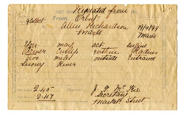 Orbost & District Historical Society
telegram, April 1899
This message concerned the P.S. Curlip's entry to the Snowy River Lakes Entrance. It was logged at 2:45 and received at 2:47.This item is associated with the P.S. Curlip and the Richardson family, early Orbost pioneers.A white paper telegram with blue print and details hand-written in black ink. It has been sent fro Orbost to "Allen Richardson Marlo". The handwritten message is difficult to decipher."You may enter - engine driver Curlip within two miles outside Entrance Snowy River."telegram-richardson-curlip communications-19th-century -
 Flagstaff Hill Maritime Museum and Village
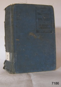
Book - Novel, H Rider Haggard, author, The Treasure of The Lake, 1926
This book is one of two that were published posthumously after the death of author Sir H Rider Haggard. H. Rider Haggard (1856-1925) was a British author who wrote fiction and non-fiction works and had letters and articles published in newspapers and journals. The book is part of Flagstaff Hill's Pattison Collection. The book was published by the British firm Hutchinson & Co. operated for almost 100 years 1887-1985, before it underwent several mergers.This book is significant for being published after the death of the author Sir H Rider Haggard. The book has additional importance for its connection to the Pattison Collection, which, along with other items at Flagstaff Hill Maritime Village, was originally part of the Warrnambool Mechanics' Institutes’ Collection. The Warrnambool Mechanics’ Institute book collection has historical and social significance for its strong association with the Mechanics Institute movement and its important role in people's intellectual, cultural and social development throughout the latter part of the nineteenth century and the early twentieth century. The collection of books is a rare example of an early lending library and its significance is enhanced by the survival of an original collection of many volumes. The Warrnambool Mechanics' Institute’s publication collection is of both local and state significance.The Treasure of The Lake Author: H Rider Haggard Publisher: Hutchinson & Co. Ltd. London Date: 1st Published in 1926 Blue fabric and board hardcover book. Inscriptions are on a label, stickers, a red stamp and handwritten. The book is part of the Pattison Collection.Label: "PAT FIC HAG" Sticker: "Warrnambool Public Library" covered by a sticker "Corangamite Regional Library Service" Red Stamp: "W'bool Public Library" Handwritten: "1303"flagstaff hill, flagstaff hill maritime museum and village, warrnambool, maritime museum, maritime village, great ocean road, shipwreck coast, pattison collection, ralph eric pattison, warrnambool mechanics’ institute, mechanics’ institute library, warrnambool library, free library, corangamite regional library service, hutchinson & co. ltd., h rider haggard, sir h rider haggard, published posthumously, 1926 -
Ringwood and District Historical Society
Programme, Ringwood City Band, Christmas Carol Festival, 18-Dec-71
1971 programme of the Carols at Ringwood Lake sponsored by the Council created and staged by City of Ringwood Band1 buff coloured eight page programme with blue printing carols at Ringwood Lake staged by the City of Ringwood Band. Sat 18-Dec- 1971; 2 faded blue application for membership of Allan's Brass Band Club +Additional Keywords: Palmer, Patricia, Mayor -
 Kiewa Valley Historical Society
Photographs x 2 1. Lake Guy & Bogong Village 2. Bulldozer moving rocks
1. In 1940 Field Headquarters for the Kiewa Scheme were established at Bogong with office, workshop facilities and accommodation for workmen, staff and some families constructed. (There had been a 'tent camp' on this site in 1939 but was destroyed by bushfires) Construction of accommodation continued until 1947. A total of 40 houses plus a hostel for single staff, post office, police station, medical centre and primary school all with water and sewerage and electricity supply. The staff hostel was known as Kiewa House and is now occupied by the Education Department. Lake Guy was named after Mr. L.T. Guy who was the Resident Engineer in charge of construction work and associated activities on the Kiewa area. He held this position from 1939 to November 1946 when he was transferred to Head Office. 2. Example of the type of heavy machinery used in clearing and building of Lake Guy, Bogong Village and Clover Dam 1. The Bogong Township was developed firstly as an accommodation centre (base camp) for construction workers employed under the Kiewa Hydroelectric Scheme. At the completion of the scheme, in the 1960's, the village was opened to public/tourism use. Strict environmental control has not allowed for any extensive redevelopment in tourist accommodation and basically restricted it to the accommodation initially built for the construction workers. Lake Guy is one of the many water storage reservoirs used to supply the power stations their main power to run the huge turbines generating the final product, electricity 2. Pictorial record of the types of machinery used in the development of Bogong Village and the Hydro-electricity scheme including the Clover Dam. Note the lack of safety equipment worn by construction workers of the period. 2 black and white photographs taken at Bogong 1. Lake Guy with Bogong Village in the background 2. Workman in bulldozer clearing rocks, possibly for construction at Bogong1. Handwritten in blue ink on back of photo 'Lake Guy showing Bogong Village' 2. No markingslake guy, bogong village, secv -
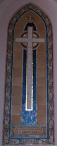 Christ Church Anglican Parish of Warrnambool
Mosaic Memorial: Florence LAKE
Florence Amanda Lake (1870-1946) was the daughter of John and Jane LAKE. Following her husband’s death, Jane married George ROLFE of ‘Lyndoch', Warrnambool. After his death Florence remained at 'Lyndoch' until moving to Melbourne in later life. Florence was noted for her charity and philanthropy. This memorial was presented by Mr George Webb of Camperdown. Florence Lake is buried in the St Kilda General Cemetery. Florence Lake was very loyal and generous parishioner of Christ Church and the Parish of Warrnambool and in the city generally. The association with George Rolfe and 'Lyndoch' is historically important.Mosaic set into blind window alcove, south wall, sanctuary, main nave. Plain white cross outlined with gold and set against a blue opus sectile mosaic on a biscuit coloured tile background bordered with stylised vine leaves and grapes.To the Glory of God, in Memory of Florence Lakelyndoch warrnambool -
 Warrnambool and District Historical Society Inc.
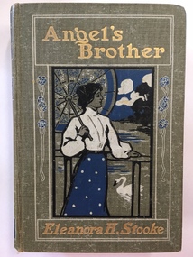
Book, Angel's Brother Eleanora H Stooke, Early 1900s
This book, ‘Angel’s Brother’ by Eleanora H. Stooke was a prize given to a pupil (name unknown) by the Christ Church Sunday School, Warrnambool in 1909. The Sunday School of the Anglican Church in Warrnambool dates from the 1850s and by 1909 it was an established tradition for most children whose parents belonged to the Anglican Church to attend a Sunday School. In 1906 there were about 30 teachers taking 45 pupils in the morning session and 177 pupils in the afternoon session. The highlights of the year were the Sunday School picnic held at various venues and the annual prizegiving day. In 1909 a cantata, ‘The Fairy Chain’ was performed by Sunday School students in the Oddfellows Hall. The Vicar in 1909 was Archdeacon Peacock (1906-1912) and in 1908 he introduced a Church Stamp System at the Sunday School whereby children were given stamps and pictures for an album to record their attendance and instruction. This book is significant because it is an example of the type of prize given to the prizewinners at the Christ Church Sunday School in Warrnambool in 1909. The prize, a book, has a story that has heavy Christian religious and moral overtones and the English Religious Tract Society produced books especially for the Sunday School prizegiving market. This is a hard cover book of 314 pages pus several pages detailing other books recently published. The book is a children’s book given as a prize by Christ Church Sunday School, Warrnambool in 1909. It has a brown cover with an inset of a sketch of a young woman holding an umbrella and a sea or a lake setting in the background. The colours of the sketch are blue, white and black and the sketch is set in a decorative border. A similar decorative pattern is on the spine of the book. There are several black and white plates in the book relating to the story. The inscription plate inside has both printed material in blue print and handwritten material in black ink. Front Cover: ‘Angel’s Brother, Eleanora H. Stooke’ Book Plate inside: ‘Christ Church Sunday School, Warrnambool, presented to Ethel … (name scratched out), Class VI, Teacher, Miss Ware, A.E.Peacock, Vicar, J.Ward, S.Smith, Superintendents, Advent, 1909.’ christ church warrnambool sunday school, archdeacon peacock, warrnambool -
 Warrnambool and District Historical Society Inc.
Medallion, Australian Felmongers Wool Sorters
This is a badge of an Australian association of fellmongers, wool sorters and scourers. This group may have been part of the Amalgamated Fellmongers, Wool Sorters and Wool Scourers Union of 1912-1918 or it may have been an earlier association. A fellmonger was a dealer in the hides or skins of animals, especially sheep, or a person who removed the skins from animals. There were several fellmongery and wool scouring establishments in 19th century Warrnambool and district. These included the Dallimore Fellmongery at Lake Gillear, the Bennett Merri Bank Fellmongery at Dennington and the fellmongery businesses of James Evenett and Henry Mawbey on the Merri River in South Warrnambool.Although it has no known local provenance, this badge is of interest because there were several fellmongery establishments in the Warrnambool district in the 19th century so it may have belonged to a local person.This medallion has a gold coloured image of a suspended lamb on a circular royal blue enamel background which in turn is surrounded by a white enamel annulus with text. The external brass edging is filigree. The medallion has an attached ring at the top with narrow gold ribbon threaded through an additional ring FELLMONGERS WOOL SORTERS & SCRS' . AUST. WOOLANDSKIN 82? G.P.O.PLACE W fellmongers, warrnambool history, dallimore fellmongery, bennett merri bank fellmongery, james evenett, henry mawbey -
 Warrnambool and District Historical Society Inc.
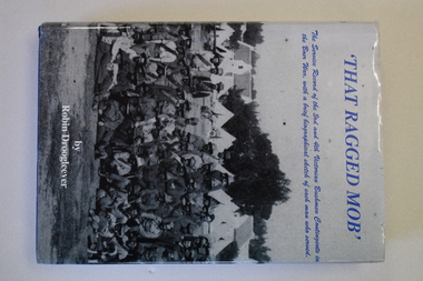
Book, That Ragged Mob, 2009
This Boer War book was written by Robin Droogleever. It is a comprehensive history of the 3rd and 4th Victorian Bushmen Contingents and gives biographical details on everyone who served in these units. Many of the men in these units came from Warrnambool and the surrounding districts and many had been members of the Mounted Rifles or the Western Artillery units before enlisting to serve in the Boer War. One of these was Major Joseph Dallimore from Lake Gillear and his diaries are used extensively in this book as a primary historical source of the events of the war.This is an important reference book detailing the history of the 3rd and 4th Victorian Bushmen Contingents in the Boer War. This book contains many references to the servicemen in the Boer War who were in those units and who came from Warrnambool and district This is a hard covered book of 706 pages. The cover is blue with gold printing on the spine. The dust cover has an off white background with a photograph of some Boer War soldiers on the front and spine and colour photographs of medals, a shoulder badge and a war memorial on the back cover.The text is in two sections with eight parts in the first section and nine parts in the second section. The book contains many black and white photographs, maps and sketches and brief biographical notes on the soldiers who served in the military units described in the book. To Elizabeth O Callaghan, my best wishes, Rob Droogleever 17/10/09boer war, warrnambool -
 Warrnambool and District Historical Society Inc.
Documents, Late 20th, early 21st centuries
These ten documents (maps, plans, photographs) mostly come from the Warrnambool City Council and most contain information on sub-divisions and titles of properties in areas around the Central Business District of Warrnambool. The dates range from 1986 to 2006. These maps, plans and photographs are of some interest as they give historical details of subdivisions in Warrnambool and date from the late 20th century. .1 This is a laminated map of the boundaries of Local Governments in Victoria. It is Sheet I of 2 and has red and blue pencil markings and black boundary markings. .2 This is a copy of a plan of a survey in black and white markings on paper. .3 This is a plan of the title details of Section 19 Warrnambool. It has black printing on buff-coloured paper. .4 This is a plan of the allotments in part of the Central Business District of Warrnambool. It is printed in black and white. .5 This is a 2006 coloured aerial photograph of the harbour at Warrnambool – Breakwater etc. .6 This is a 2006 coloured aerial photograph of the Lake Pertobe area in Warrnambool .7 This is a coloured aerial photograph of Warrnambool’s streets over-stamped with road numbers in large blockings. .8 This is a plan showing the title details of Section 11 in Warrnambool. It has black printing on buff-coloured paper. .9.1 This is a plan of sub-divisions in parts of Crown Allotments 38 & 39 in Warrnambool. It has green, pink and yellow markings with black printing. .9.2 This is a plan of the sub-divisions in parts of Allotments 38 & 39 in Warrnambool. It has pink, yellow and blue markings with black printing. It is somewhat faded. warrnambool c.b.d. maps and plans, history of warrnambool -
 Eltham District Historical Society Inc
Slide, Construction of Eltham Town Park, 25 Jul 1973
Construction of Eltham Town Park; landscape has been scupltured and lakes formed. Shillinglaw Cottage , Main Road, Eltham Shire Council Offices and Catholic Church all visible. The park was later renamed Alistair Knox Park.35 mm colour positive transparency Mount - Agfacolor Service (Blue)Memorial Park 25 July 1973eltham, main road, alistair knox park, eltham town park, shillinglaw cottage, bridge street -
 Eltham District Historical Society Inc
Slide, Construction of Eltham Town Park, 25 Jul 1973
Construction of Eltham Town Park; landscape has been scupltured and lakes formed. View looking up towards intersection of Bridge Street with Main Road. On the high side of Main Road is Garni Burges former home at the corner of Bridge Street then further to the left the former bakery on the corner of York Street. On the opposite corner is the feed store now the site of Le Pine Funerals. The park was later renamed Alistair Knox Park.35 mm colour positive transparency Mount - Agfacolor Service (Blue)Memorial Park 25 July 1973eltham, main road, alistair knox park, eltham town park, shillinglaw cottage, bridge street