Showing 45 items
matching cadastral
-
 Bacchus Marsh & District Historical Society
Map, Trentham Parish Map 1905 Copy 1
A single page paper map showing the map for the Parish of Trentham in the Counties of Dalhousie and Bourke. A cadastral map showing parish boundaries and land ownership. The map is pasted into a bound volume containing 76 maps or plans in total. High resolution digital image stored on BMDHS computer network. Photo-lithographed at the Department of Lands and Survey, Melbourne by T.F. McGauran 22.3.05 trentham parish maps, trentham parish plan, bacchus marsh region parish plans -
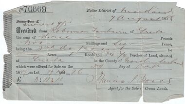 Bendigo Historical Society Inc.
Administrative record - Land purchase records - Maitland NSW, 1888-1889
Northumberland County was one of the original Nineteen Counties in New South Wales and is now one of the 141 Cadastral divisions of New South Wales. The Greta area was first colonized by Europeans around Anvil Creek in the 1830s. When the town was surveyed in 1842 it was given the name Greta, possibly after a small river in Cumberland, England. Coal mining was established in the area in 1862 with the development of a railway station.Robinson Fairbairn Collection: Two documents. 1. Receipt for payment from Robinson Fairbairn of Greta for purchase of land at Greta, NSW. Dated 7th August 1888. Receipt for £3/11/11 includes Interest noted at top. 2. Invoice to Mr. Robinson Fairburn for land purchase in account with Sparke and Clift, Auctioneers, West Maitland. mining, robinson fairbairn collection, maitland, northumberland, greta nsw, sparke and clift, coal -
 Bacchus Marsh & District Historical Society
Map, Village allotments, Parish of Myrniong, County of Bourke
Myrniong is a village 9 kilometers west of Bacchus Marsh. Prior to 1863 the area was known as Blow's Flat. This map which was produced in 1903 and according to the catalogue record of this map held at the State Library of Victoria was based on an earlier map created in 1861. The early layout of streets for the village of Myrniong can be seen on this map. The streets shown are, Main Street, Hardy Street, Blow Street, Myrniong Street, Shuter Street, and Blackwood Street. An area marked as a reserve for a school can be seen between Hardy Street and Main Street.A single page paper map. A cadastral parish map of Myrniong in Victoria, showing numbered land allotments. Photo-lithographed at the Department of Lands & Survey, Melbourne, in 1903. Based on an original map created in 1861. The map is pasted into a bound volume containing 76 maps or plans in total. High resolution digital image stored on BMDHS computer network. Surveyed by John Hardy, Surveyor ; photo-lithographed at the Department of Lands & Survey, Melbourne by T.F. McGauran, 24.12.03myrniong parish plan, myrniong parish maps -
 Bacchus Marsh & District Historical Society
Map, Allotments in the Village of Rowsley, Parish of Gorrocburkghap, County of Grant c.1856
Rowsley is a locality 11 kilometers south-west of Bacchus Marsh. The date of this map is uncertain. A very similar map held by the State Library of Victoria (SLV) contains slightly more information than this copy and is dated as an 1856 map. SLV reference: 'Allotments in the Village of Rowsley, Parish of Gorrocburkghap, County of Grant', by T. Nixon, Assistant Surveyor, May 1856 ; Surveyor General’s Office, July 18 1856 (lithographed by R. Meikle). (1856). Melbourne: Surveyor General’s Office. MAPS 820 BJE 1837- ROWSLEY 1856. A single page paper map. A cadastral map of the Village of Rowsley in Victoria, showing numbered land allotments. 57 allotments are shown on the map and some areas set aside as reserves. Allotments 8, and 10-16 are outlined in red ink and allotment 9 has a cross in red ink on it. The map is pasted into a bound volume containing 76 maps or plans in total. High resolution digital image stored on BMDHS computer network. rowsley victoria history, rowsley victoria maps -
 Ringwood and District Historical Society
Map - State Aerial Survey, Dandenong Ranges Area Sheet 7, Parishes of Warrandyte, Scoresby, Ringwood and Nunawading - 1956
Map of central and southern areas of Ringwood and part of Ringwood East and Heathmont compiled by Dept of Lands and Survey, July 1956, from aerial photographs and Cadastral Survey information. Subsequent coloured hand-drawn additions showing layout of a number of post-NSW Separation era proposed subdivisions that did not eventuate, including Village of Studley Estate, Township of East Kew Estate, Township of Ballyduffy Estate, Township of New Flemington Estate, Township of East Hawthorne Estate. Ringwood A4B2, 849 A4B Zone 7. Scale: 10 chains to 1 inch. Contour interval 20 feet. -
 Bacchus Marsh & District Historical Society
Map, Bullengarook Parish, County of Bourke
An undated parish plan map for the parish of Bullegarook. This parish area is close to the Bacchus Marsh district and borders some of the areas contained within the former Bacchus Marsh Shire and present day Moorabool Shire.A single page paper map showing the parish plan map for Bullengarook. This parish area contains the locality of Bullengarook and parts of the Wombat State Forest and is close to the town of Gisborne. A cadastral map showing land ownership. The map is not dated but a very similar map held by the State Library of Victoria is estimated to date from about 1927. The map is pasted into a bound volume containing 76 maps or plans in total. High resolution digital image stored on BMDHS computer network. bullengarook parish maps -
 Federation University Historical Collection
Plan, City of Ballarat (Part) (Ballaarat East), 08/05/1928
Crown Cadastral Plan showing Governement Roads, Crown Parcels, Dimensions, Crown grantees, dated of grants, etc in Ballarat East. The plan shows features such as Bakery Hill, Canadian Station, recreation reserves, timber reserves, Yarrowee Creek, Black Hill Reserve, Eureka Reserve and Garden, Orphan Asylum, Rifle Butts Reserve, Ballarat Woollen Mill, Ballarat Observatory, Sovereign Hill Recreation Reserve, Specimen Vale, Market Reserve, Cemetery WGS 84 Centroid 37 degrees 33' 55" S 143 degrees 52' 38" E E.W. Extent; 5 km N-S Extent; 4 kmmap, plan, ballarat east, ballarat woollen mill, ballarat railway line, ballarat railway station, eureka reserve, eureka cemetery, ballarat orphanage, russell square, bakery hill -
 Bacchus Marsh & District Historical Society
Map, Bacchus Marsh Township and Nearby Districts Maps Volume
This volume of maps is believed to have been compiled by staff at the Shire of Bacchus Marsh and was presumably used to inform and assist Shire staff and Councillors in the carriage of their duties.This collection of maps are significant due to their rarity as many of them are unique maps made for local purposes in the Bacchus Marsh region. They are also of strong research value containing a wide variety of information including landholders, land sales, infrastructure, such as roads, bridges, public, commercial and private buildings, houses, land use, and geographic features over multiple decades from the late nineteen century into the middle part of the twentieth century.One bound volume of maps comprising cadastral maps, (indicating property owners and land boundaries), land plans and real estate auction plans and advertising material, and other maps indicating major infrastructure like proposed roads and irrigation areas. Most of the maps and plans are of Bacchus Marsh and nearby areas but some maps are of nearby towns such as Melton, Ballan and Blackwood. The volume comprises 52 pages. Most pages have a single map or plan pasted onto it but some contain 2 or 3 different maps. There are 81 maps in total. Map 1 Liquidators Sale 1896. Map 2. Woodside Estate Sale 1913. maps, maps bacchus marsh, maps bacchus marsh region -
 Ringwood and District Historical Society
Map - State Aerial Survey, Dandenong Ranges Area, Parishes of Warrandyte and Ringwood - 1956
Map of central and southern areas of Ringwood and part of Ringwood East and Heathmont compiled by Dept of Lands and Survey, July 1956, from aerial photographs and Cadastral Survey information. Subsequent hand-drawn addition of streets showing layout of "Township of Ballyduffy Estate 1858-60", an earlier proposed subdivision that did not eventuate. (See attached 5009b Ballyshanassy_ Melbourne’s lost suburb.pdf for Ballyduffy historical naming relevance). Ballyduffy Estate streets include City Road, West Prussia Road, Duffy Street, Ireland Street, Evans Street, Victoria Street, Regina Street, Short Road, Prussia Road, Duffy Street East, Ireland Street East, Evans Street East, Chapman Street. Misc Topo 93 Sheet 22, Ringwood A4B2. Scale: 4 chains to 1 inch. Contour interval 20 feet. -
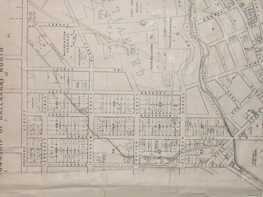
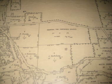 Federation University Historical Collection
Plan - Plan - Cadastral, Parish of Ballaarat - Sheet 3 (only), 03/03/1932
Sheet 3 of the Parish of Ballart showing Government roads, crown allotments, dimensions, crown grantees, date of grants, etc,ballarat, plan, hospital for contagious diseases, sebastopol, sebastopol rifle range, fiscalini, leigh river, yarrowee creek -
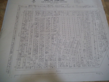
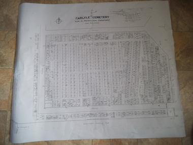 Rutherglen Historical Society
Carlyle Cemetery Map, Plan of Presbyterian Compartment, 1952
This is a map produced to attempt to bring order to the cemetery. Originally the layout was not well defined and it is difficult to use this plan to locate a particular grave, also the fact that not all graves are marked and foot paths are not defined has exacerbated this issue. Photocopy, White paper, black printing, black line work showing lot and compartment boundariesReferences Grid Survey points at 50 feet centres shown (as a cross with the reference mark number in brackets) Lot Number shown at left side of graves. Burial Number shown at right side of grave. Lots with unidentified burials show with dashed cross with in the lot. topographic survey, cadastral survey, carlyle cemetery, burials, graves, lot boundary, rotunda -
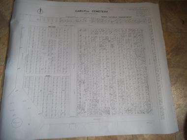 Rutherglen Historical Society
Carlyle Cemetery Map, Plan of Roman Catholic Compartment, 1952
This is a map produced to attempt to bring order to the cemetery. Originally the layout was not well defined and it is difficult to use this plan to locate a particular grave, also the fact that not all graves are marked and foot paths are not defined has exacerbated this issue. Photocopy, White paper, black printing, black line work showing lot and compartment boundariesReferences Grid Survey points at 50 feet centres shown (as a cross with the reference mark number in brackets) Lot Number shown at left side of graves. Burial Number shown at right side of grave. Lots with unidentified burials show with dashed cross with in the lot. topographic survey, cadastral survey, carlyle cemetery, burials, graves, lot boundary, rotunda -
 Rutherglen Historical Society
Carlyle Cemetery Map, Plan of Church of England Compartment, 1952
This is a map produced to attempt to bring order to the cemetery. Originally the layout was not well defined and it is difficult to use this plan to locate a particular grave, also the fact that not all graves are marked and foot paths are not defined has exacerbated this issue. Photocopy, White paper, black printing, black line work showing lot and compartment boundariesReferences Grid Survey points at 50 feet centres shown (as a cross with the reference mark number in brackets) Lot Number shown at left side of graves. Burial Number shown at right side of grave. Lots with unidentified burials show with dashed cross with in the lot. topographic survey, cadastral survey, carlyle cemetery, burials, graves, lot boundary, rotunda -
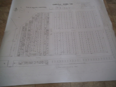 Rutherglen Historical Society
Carlyle Cemetery Map, Plan of Wesleyan Compartment, 1952
This is a map produced to attempt to bring order to the cemetery. Originally the layout was not well defined and it is difficult to use this plan to locate a particular grave, also the fact that not all graves are marked and foot paths are not defined has exacerbated this issue. Photocopy, White paper, black printing, black line work showing lot and compartment boundariesReferences Grid Survey points at 50 feet centres shown (as a cross with the reference mark number in brackets) Lot Number shown at left side of graves. Burial Number shown at right side of grave. Lots with unidentified burials show with dashed cross with in the lot. topographic survey, cadastral survey, carlyle cemetery, burials, graves, lot boundary, rotunda