Showing 133 items
matching clunes creeks
-
 Clunes Museum
photograph
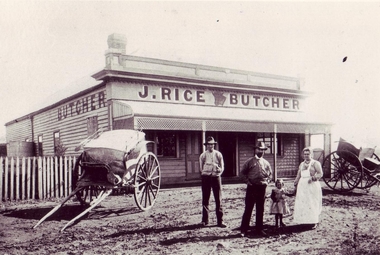
... NO RECORD OF SHOP IN CLUNES. MAYBE IN COGHILLS CREEK... OF SHOP IN CLUNES. MAYBE IN COGHILLS CREEK ACCORDING TO C.H.F ...NO RECORD OF SHOP IN CLUNES. MAYBE IN COGHILLS CREEK ACCORDING TO C.H.F.BLACK AND WHITE PHOTOGRAPH OF MR. J. RICE'S BUTCHER SHOP. 2 BUTCHER'S CARTS.- STANDING,- MR. JOSEPH RICE [WITH BEARD] MRS. MARGARET RICE, (NEE AIKMAN) - DAUGHTER, FRANCIS FANNY RICE, NOW MRS. BROWN (EAGLE HAWK)J. RICE BUTCHERlocal history, photography, photographs, shops, j. rice butcher shop., buildings -
 Clunes Museum
Photograph, CIRCA 1859
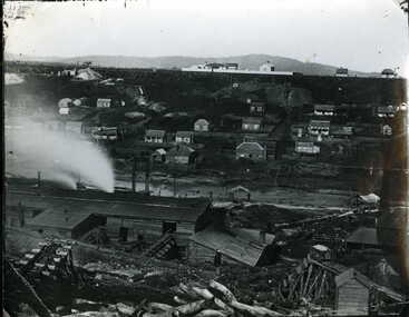
... NO.3 CAMP PARADE, CLUNES, OPPOSITE SIDE OF CREEK....Clunes Museum 36 Fraser Street Clunes goldfields NEGATIVE ...NEGATIVE OF THIS PHOTO IS AT LATROBE LIBRARY, LATROBE STREET, MELBOURNE. THE PHOTO WAS GIVEN TO THE MUSEUM BY MR.F.C.WEICKHARDT, 1970.A PHOTOGRAPH OF THE PORT PHILLIP MINE BATTERY TAKEN FROM NO.3 CAMP PARADE, CLUNES, OPPOSITE SIDE OF CREEK.local history, photography, photographs, mining -
 Clunes Museum
Photograph
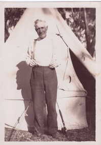
... . TEENA DAVIES, CREEK PARADE, CLUNES.... DONATED TO CLUNES MUSEUM BY BERYL WARD OF MR. TEENA DAVIES, CREEK ...SNAPSHOT DONATED TO CLUNES MUSEUM BY BERYL WARD OF MR. TEENA DAVIES, CREEK PARADE, CLUNES.SNAPSHOT TEENA DAVIES STANDING OUTSIDE TENTUNCLE TEENA - CLUNESlocal history, photography, photographs, davies teena -
 Clunes Museum
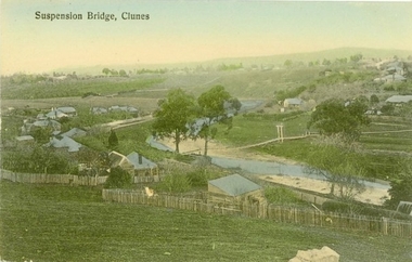
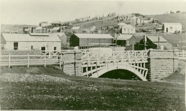
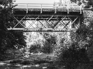
Photograph - POSTCARD, PRINTED IN GERMANY, SUSPENSION BRIDGE, CLUNES
... THE SUSPENSION BRIDGE OVER CRESWICK CREEK, PLACED AT CREEK...THE SUSPENSION BRIDGE OVER CRESWICK CREEK, PLACED AT CREEK ...THE SUSPENSION BRIDGE OVER CRESWICK CREEK, PLACED AT CREEK PARADE CLUNES, WAS WASHED AWAY IN A SEVERE FLOOD.COLOURED PHOTOGRAPH OF SUSPENSION BRIDGE CLUNES. PRODUCED AS A POSTCARD - 2 COPIES. ANOTHER COPY HAS BEEN ENLARGED TO A4 SIZE AND LAMINATED - 760.2SUSPENSION BRIDGE - CLUNESlocal history, document, postcard, bridges -
 Stawell Historical Society Inc
Coin - Realia, R. PARKER IRONMONGER GEELONG MOORABOOL STREET
... BY RICHARD PARKER. PARKER WENT ON TO ESTABLISH STORE IN CLUNES... ON TO ESTABLISH STORE IN CLUNES, BACK CREEK (TALBOT), FIREY CREEK ...HEATON & SONS, BIRMINGHAM WERE EMPLOYED TO STRIKE THE EXTENSIVE TOKEN ISSUES. THE IRONMONGERY STORE IN MOORABOOL STREET, GEELONG WAS ESTABLISHED IN 1844 BY RICHARD PARKER. PARKER WENT ON TO ESTABLISH STORE IN CLUNES, BACK CREEK (TALBOT), FIREY CREEK AND ARARAT. HE ISSUED AT LEAST TEN VARIETIES OF TOKENS, ALL WITH THE SAME INSCRIPTION AND FIGURE ON THE FACES, BUT WITH SLIGHT VARIATIONSCOPPER PENNY TOKEN 34MM OR 35 MM DIAMETER OBVERSE: INSCRIBED WITH R PARKER IRONMONGER MOORABOOL STREET GEELONG REVERSE: HAS A FEMALE FIGURE REPRESENTING JUSTICE, HOLDING A BALANCED SET OF SCALES IN HER RIGHT HAND. THE WORD AUSTRALIA IS AROUND THE TOP OF THE TOKEN. ,token coin -
 Clunes Museum
Photograph
... PHOTOGRAPH OF GOVERNMENT BRIDGE OVER CRESWICK CREEK...BLACK AND WHITE PHOTOGRAPH OF BRIDGE OVER CRESWICK CREEK... OF GOVERNMENT BRIDGE OVER CRESWICK CREEK ON CRESWICK ROAD, CLUNES ...PHOTOGRAPH OF GOVERNMENT BRIDGE OVER CRESWICK CREEK ON CRESWICK ROAD, CLUNES. PHOTOGRAPH DONATED BY CRESWICK MUSEUM. COPIED BY MR. SEMMENS FROM AN EARLIER PHOTOGRAPH.BLACK AND WHITE PHOTOGRAPH OF BRIDGE OVER CRESWICK CREEK AT CLUNES - GOVERNMENT BRIDGE, CRESWICK ROAD. EBERHARDS SOFT DRINK FACTORY IN CENTRE OF PHOTOGRAPH.local history, photography, photographs -
 Clunes Museum
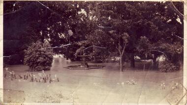
Photograph, FLOODS 1934
... AFTER HEAVY RAINS - CRESWICK CREEK IN CLUNES TOWNSHIP...AFTER HEAVY RAINS - CRESWICK CREEK IN CLUNES TOWNSHIP ...AFTER HEAVY RAINS - CRESWICK CREEK IN CLUNES TOWNSHIP FLOODED, OVER FLOWING ITS BANKS, NEAR BY AREAS WERE SUBMERGED.BLACK AND WHITE SMALL PHOTOGRAPH OF CLUNES FLOODS IN 1934. CLUNES QUEEN'S PARK WITH FOUNTAIN UNDER WATER - TREES IN THE BACKGROUND AND A FEW FLOWERS IN THE FOREGROUND.local history, queen's park garden., floods 1934 -
 Bendigo Historical Society Inc.
Slide - DIGGERS & MINING. THE GOLD ERA, c1851
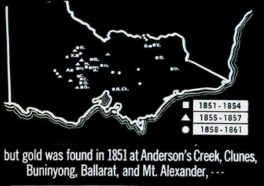
... Creek, Clunes, Buninyong, Ballarat, and Mt. Alexander... Diggers & mining. But gold was found in 1851 at Anderson's Creek ...BHS CollectionDiggers & mining. But gold was found in 1851 at Anderson's Creek, Clunes, Buninyong, Ballarat, and Mt. Alexander, - - - Slide shows map of Victoria with legend to show when gold was found in different areas. The gold era. Markings 4 994.031 GOL:5. Used as a teaching aid. Used as a teaching aid.hanimounteducation, tertiary, goldfields -
Clunes Museum
Document - VARIOUS DOCUMENTS, PRESBYTERIAN CHURCH
... CELEBRATIONS (SERVICE OF INAUGURATION CLUNES, COGHILLS CREEK, EVANSFORD... (SERVICE OF INAUGURATION CLUNES, COGHILLS CREEK, EVANSFORD, TALBOT ....1 FOUR PAGES OF VERSES SCOTTISH THISTLE GREEN ON BEIGE ON CARDBOARD COVER WITH A PIECE OF TARTAN GLUED ON FRONT PRINTED ON FRONT: "NOW FARE YE WEEL, AND JOY BE WI' YOU" - BURNS .2 BROCHURE ST ANDREWS PRESBYTERIAN CHURCH CENTENARY CELEBRATIONS (SERVICE OF INAUGURATION CLUNES, COGHILLS CREEK, EVANSFORD, TALBOT) .3 INVITATION TO ST ANDREWS CENTENARY CELEBRATIONS JULY 14 TO 22ND 1962 .4 ST ANDREWS PRESBYTERIAN CHURCH, PROGRAMME OF CENTENARY CELEBRATIONS JULY 14 TO 22ND 1962 .5 POSTCARD OF COGHILLS CREEK PRESBYTERIAN CHURCH .6 PLEDGE BOOKLET ST. ANDREWS PRESBYTERIAN CHURCH "THE CONTINUING CHALLENGE" 8 PAGES .7 LETTER FROM MR. W J COOK, CAMPAIGN CHAIRMAN SEEKING STEWARDSHIP SUPPORT FOR THOSE NOT ATTENDING THE DINNER .1 PRINTED AT YE SIGNE OF YE LION RAMPANT BY W.B. MACDONALD, LYDIARD STREET, BALLARAT MCMLVIII .6 YOUR CHURCH WANTS YOU! YOUR CHURCH NEEDS YOU! .7 HAND SIGNED BY WALTER J COOKst. andrews presbyterian church, centenary celebration, 1862-1962 -
Clunes Museum
Weapon - NAVAL CANNON, 1847
... TREE NEAR THE CREEK IN CLUNES.... FOR THE RESTORATION WAS TAKEN FROM AN ELM TREE NEAR THE CREEK IN CLUNES. local ...IT IS ON PERMAMENT LOAN FROM HEPBURN SHIRE THE CANNON WAS ORIGINALLY ON THE BRITISH NAVAL SHIP "NELSON" IN FEBRUARY 1867. "NELSON" WAS HANDED OVER TO THE VICTORIAN NAVAL FORCES, ON LOAN FROM THE ROYAL NAVY. "NELSON" WAS SOLD 1898, IT IS BELIEVED THAT THE GUNS WERE THEN OFFERED FOR SALE TO COUNCILS. IT WAS DISPLAYED ON A SITE NEAR THE SCENIC ROAD, CLUNES, UNTIL THE WOODEN UNDERCARRIAGE WAS DESTROYED BY THE BUSHFIRES IN 1944. IT WAS LATER RETRIEVED AND KEPT IN THE CLUNES BOROUGH COUNCIL YARD UNTIL IT WAS RESTORED BY THE APPRENTICES AT THE BENDIGO ORDNANCE WORKSHOPS IN 1895. THE TIMBER USED FOR THE RESTORATION WAS TAKEN FROM AN ELM TREE NEAR THE CREEK IN CLUNES..1 NAVAL CANNON MOUNTED ON A WOODEN UNDERCARRIAGE. .2 CANNON BALLlocal history, military history, navy, military -
 Bendigo Historical Society Inc.
Document - MINING REPORTS - GOLD PER ESCORT TAKEN TO TREASURY VICTORIA 1860-1
... , Creswick, Fiery Creek, Ararat, Pleasant Creek, Smythesdale, Clunes... Creek, Ararat, Pleasant Creek, Smythesdale, Clunes, Beechworth ...Gold Return showing the amount of Gold brought to the Treasury, per Escort, during the year 1860, from each gold office. Printed on pale blue paper and dated 11th January, 1861. Blue Royal Historical Society of Victoria Bendigo Branch stamp at the left top of page. Gold Offices mentioned are: Castlemaine, Blackwood, Maldon, Sandhurst, Heathcote, Rushworth, Kilmore, Maryborough, Avoca, Back Creek, Dunolly, Inglewood, Amherst, Ballaarat, Creswick, Fiery Creek, Ararat, Pleasant Creek, Smythesdale, Clunes, Beechworth, Buckland, Yackandandah, Indigo and Morse's Creek. Document is part of the Albert Richardson Collection. document, gold, mining reports, mining reports, gold returns victoria 1860-1, mr carpenter, john wilkinson, john ferres -
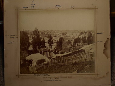 Clunes Museum
photograph, FROM CAMP PARADE, LOOKING EAST
... CREEK PARADE, CLUNES. C1876 .1 BLACK AND WHITE MOUNTED... PHOTOGRAPH OF CLUNES TOWNSHIP - FRASER STREET FROM CREEK PARADE ...PHOTOGRAPH OF CLUNES TOWNSHIP - FRASER STREET FROM CREEK PARADE, CLUNES. C1876 .1 BLACK AND WHITE MOUNTED ON CARDBOARDF .2 BLACK AND WHITE PHOTO PRINT .3 BLACK AND WHITE PHOTO PRINT .4 BLACK AND WHITE PHOTO PRINT .5 BLACK AND WHITE PHOTO PRINT .6 BLACK AND WHITE PHOTO PRINT .7 SMALL BLACK AND WHITE PHOTO PRINT .8 SMALL BLACK AND WHITE PHOTO PRINT .9 SMALL BLACK AND WHITE PHOTO PRINT .10 B LACK AND WHITE PHOTO PRINT .11 SEPIA MOUNTED PHOTO WITH POINTS OF INTEREST WRITTEN ON MOUNTING .12 SEPIA MOUNTED PHOTOlocal history, photography, photographs, clunes township -
Clunes Museum
Photograph - PHOTOGRAPHS
... CREEK IN CLUNES .1QUEENS PARK .2 BLACKMORE ROAD .3 BOWLING GREEN...CLUNES FLOODS 2010 CRESWICK CREEK FLOOD 23 X COLOURED ...23 X COLOURED PHOTOGRAPHS OF THE 2010 FLOODING OF CRESWICK CREEK IN CLUNES .1QUEENS PARK .2 BLACKMORE ROAD .3 BOWLING GREEN .4 LIGAR STREET .5 QUEENS PARK .6 TOWARDS BOWLING GREEN .7 QUEENS PARK .8 BOWLING GREEN .9 SENIOR CITIZENS .10 THE OVAL .11 33 ANGUS STREET .12 WATER CURRENTS .13 LOOKING TOWARDS FORMER TONY BAILEY'S HOUSE .14 ANGUS STREET .15 LOWER FRASER STREET .16 CORNER CAMERON STREETS - FLOOD PEAK AT 5PM .17 AT GOVERNMENT BRIDGE .18 LOOKING DOWN CAMP HILL .19 FORD .20 BUTTER FACTORY BRIDGE .21 BESIDE BOWLING GREEN .22 BUTTER FACTORY BRIDGE .23 DAMAGE AT FORD clunes floods 2010, creswick creek flood -
Clunes Museum
Painting - PAINTINGS, David Williams
... The Coghill Monument Former Methodist Church Coghills Creek Clunes... The Coghill Monument Former Methodist Church Coghills Creek Clunes ...Images of; Horse Trough & Wagon Residence 94 Bailey Street Former Presbytery St. Thomas Aquinas Former Clunes Free Library Residence 25 Camp Street Monument 100 years of gold Clunes in Melb Monument Former butcher's shop Fraser Street Residence & shops 41-43 Fraser Street Clunes School of Mines Clunes War Memorial Residence 32 Leslie St Clunes Former suspension bridge Former St Paul's Vicarage 42 Service Street Former Police Office Former Police residence Portable Lock Up Former Dow Residence 9 Hill St Former Hall & Fire Station 2 Hill St St Paul's timber Church hall St Paul's Church Masonic Lodge 23 Service St St Paul's Pulpit Masonic Lodge interior Everhard cordial bottles Scythes in Clunes Museum Ascot Blacksmith shop Former Ascot hotel MIA Hall Ascot The Coghill Monument Former Methodist Church Coghills Creek Clunes Cemetery Chapel Maiden Hill Homestead shearing shed Beckworth Court stables Beckworth Cour shearer's quarters Former School Evansford Glengower Outbuilding Amerst Former Mortuary 46-50 Fraser Street Wood fired heater Beckworth court farm shed Gold mine trolley Servant's bells Maiden Hill cow bail Former South Clunes school 29 George Street 70 Fraser Street Former Post Office "Allowah" Clunes Street Ascot "Homestead" Beackwith Court "The Meat House" Beckwith Court "Shearing Sheds" Beckwith Court Evansford Community Hall 54 watercolours remaining from the 2003 exhibition held at Clunes, all unframed, depicting Clunes and surrounds architecture and streetscapes.BY DAVID WILLIAMSwatercolour, 2003 exhibition -
Federation University Historical Collection
Document, Zelda Martin, Central Victorian Goldmining towns - Boom Towns or Ghost Towns?, c1996
Zelda Martin was a PhD candidate at the University of Melbourne.[.1] 4th item in light blue display book titled Research Approach/Overview of Chapters/Confirmation of Canditure/Chapters1,2,3&4 of proposed thesis. *Twenty-seven page article on Victorian goldfields towns titled: Central Victorian Goldmining Towns - Boom Towns or Ghost Towns. The article was written during the author's PhD study. It outlines the context methodology, and resources and the chapters of the proposed thesis: (1) Central Victorian Goldmining Towns - The Context (2) Contemporary Views of the Factors Necessary for Town Growth (3) Outward Manifestations of Town Growth (4) The Trappings of Government (5-9) The Main Towns and Their Hinterland. [.2] 5th item in Light Blue display book as above item. *Chapter 1 of proposed thesis titled 'Pick, Shovel and Tin Dish Mining.' Covers in Section A: Central Victoria - Pre 1851: Aborigines in Central Victoria, Squatters, and Government. Section B: The years 1851-1854: The Early Gold Rushes, Government Reaction, Township Surveys, Legislation, Town Development, Local Government and Early Settlement. [.3] 6th item in Light Blue display book as above item. *2A of proposed thesis titled 'Contemporary Views of the Factors Necessary for Town Growth'. Similar information to Chapter 1 plus extra re towns and maps. Sections: Introduction, Context of Place - Geographical Towns Listed, The Context of Time - Pre1851 Aborigines, Governance of Port Phillip, The Squatters, The Villages of Central Victorian Highlands, Conclusion, Condensed Version of Chapter2B. [.4] 7th item in Light Blue display book as above item. *Chapter2B of proposed thesis. Sections: Area of Research, Schools, Banks, Newspapers, Progress Association, Town Development - Sandhurst (Bendigo), Ballarat, Castlemaine,, Maryborough, Ararat and Stawell. [.5] 8th item in Light Blue display book as above item. *Chapter 3 of proposed thesis titled 'Outward Manifestations of Town Growth'. Sections: Introduction, Contemporary Writing, Educationalists, The Bankers, The Townsfolk, Current Theory, General Theories of Urban Development, and Conclusion. [.6] 9th item in Light Blue display book as above item. *Chapter 4 of proposed thesis titled 'Trappings of Government' Sections: Introduction, Early Government Attitudes to Mining and Town Development, Law and Order, Township Surveys, Legislation, Local Government, Transport and Communication, The People and Lobbyists. [.7] 10th item in Light Blue display book as above item. *'The Rise and Fall of Central Victorian Goldmining Towns'. Includes a map showing main Goldfields, a table showing towns and villages at two points in time - 1857 and 1871; a Bibliography of Primary and Secondary Sources. [.8] Resource No1. Black display book titled Local Towns 1 : Alma: *Brief history *Directory *Maps Amphitheatre / Mountain Hut: *Brief History Post Office Directory Ararat: *Brief History *Post Office Directory 1869 - Alphabetical Listing by Occupation *Ararat - Prominent Citizens of 1858 *Langi-Morgala Museum Avoca: *Brief History *Excerpts from 'Avoca The Early Years', Margery and Betty Beavis; pg1 - Beginnings; pg11 - The Midas Touch; pg25 - Local Gold Escorts; pg27 - A Town is Born; pg51- The Administration of Justice; pg53 - The Ways of the Law; pg61 - News of the Day; pg65 - A Time to Play; pg72 - Land Ownership *Post Office Directory (Bailliere's) 1869 *Tourism Map and Information of area *Historic Avoca - A 5.5km Tour *Avoca & the Pyrenees Region - information pamphlet Ballarat: *Early History of Ballarat - Ballarat Historical Society, Publication No.1: origin of the name; Ballaarat - the Beginning; Fabulous Yields from the Ballaarat Goldfield; *Streetscape Lydiard Street. *Hand drawn map showing Leigh River, Old Portland Bay Road, plaque on road to Colac; etc. *Newspaper article re 'The Theatre Royal' ( which stood in the vicinity of the current Owen Williams store) - 'The News'15/04/1998 *Article - 'Ballarat's Mechanics' Institute Lives On' Ballarat Courier, 14/09/1985 *Article - Standing the Test of Time' The News 17/11/1993 re The Mechanics Institute & picture of the Reading Room *'Ballarat a Study of a City, Phyllis Reichl, pub. Nelson, 1968; no.3 place, time and people field studies series *Investigator Vol.33 No.2, 1998 Geelong Historical Society. Article on pg75 describes Ballarat in 1861 *Folded poster - 'Ballarat 100' a history of telegraph communication, pub. Telecom. Beaufort (Fiery Creek): *Brief history *Post Office Directory [.9] Resource No.2 Black Folder Titled Towns cont.No2 Bendigo (Sandhurst): *'Family & Local History at the Bendigo Library - 1851-2001 150 years of gold'. *Bendigo Government Camp in 1853 illustration; key to sketch and names of Government officers stationed there *Excerpts from 'Bendigo and Vicinity' Adolph Haman *The Bendigo Goldfield Registry - pgs 1-7 Introduction *Excerpt: 'Breaking the Grip' *Excerpt: The Most Go-Ahead Place *Excerpts from 'History of Bendigo' - anti license agitation; laying out of town; proposed railway; gold calls and dividends; the Sandhurst Municipality; journalism *Bibliography Blackwood: *Excerpts from 'Aspects of Early Blackwood - The Goldfield, the Landmarks, the Pioneers' Alan J Buckingham and Margaret F Hitchcock, JG Publishing,1980 Buninyong: *A Brief History *Investigator Vol1 No.2 Feb 1966 Geelong Historical Society. Pg3 - Article re gold escort route - Mt Alexander to Adelaide - (see a simple monument on the Western Highway a few miles out of Horsham. Pg 15 - Ballarat Excursion - re the finding of gold. *Three articles published by Buninyong and District Historical Society Inc: (Magpie Exploration; Finding Gold In The Green Hills; Magpie Exploration; Burnt Bridge to Cargarie to Mt Mercer) *Copies of newspaper articles/items *Buninyong Street Directory Carisbrook: *In the Beginning There Was Carisbrook *The History of the Carisbrook Racecourse Carngham / Snake Valley: *Brief History *Directory Castlemaine: *Directory 1865-1866 - Alphabetical and Street *Poster - Castlemaine A Contemporary Guide "The Great Centre" 1866 - A Contemporary Guide to the Fascinating Past *Pamphlet - Castlemaine District Community Hospital *Map - Castlemaine, Maldon & Surrounding Districts *Map and Information - The Dry Diggings Track - a 55kl walk among historic goldfields relics ( Castlemaine Fryerstown Vaughan Mt Franklin Hepburn Daylesford) *Postcard - Former Court House *Directory 1867 - Alphabetical, Trade [.10] Resource No.3 Grey folder Titled Towns 3 Creswick to Maryborough Creswick: *Brief History *Booklet - "Creswick Cemetery Walk" *Booklet - The Buried Rivers of Gold Heritage Trail Creswick *Creswick Historical Museum Information Sheet *Chronological History of Creswick *Alphabetical Directory of the Borough of Creswick *Creswick's Creek Directory 1856 *Historic Creswick Walking Tour *A Brief Account of the Schools of Creswick - Past and Present *100 Years of Railway Travel in Creswick *The Berry Deep Leads *The Spence Home at Jackass Gully in the Creswick State Forest ( William Guthrie Spence - Pioneer) *The New Australian Mine and the 1882 Disaster *Creswick District News, Issue 7, July August 1999 *The Creswick Miners Walk - Information and Map *Maps Chewton: *Brief History *Directory Clunes: *Brief History *Clunes Street Directory Daylesford: *Brief History *Notable Bushfires in Daylesford District Over More Than a Century - "Black Thursday" 1851; 1862; 1899; the Disastrous Hepburn Fire of 1906; 1939; 1944; 1969. *Post Office Directory -Daylesford and Hepburn Dunolly / Inkerman: *Brief History *Directory *Pamphlet - Goldfields Historical Museum *Pamphlet - Historic Dunolly - Victoria's Best Kept Secret *Map of Gold Workings at Dunolly Area - showing where the main gold rushes occurred *Brief History - Inglewood *Directory - Inglewood - Name Occupation, Dwelling Kingower: *Brief History *Directory - Name / Ocupation / Dwelling Linton / Happy Valley / Piggoreet: *Brief History *Directory - Lintons McIvor: *"A History of the Shire and the Township of Heathcote" by J.O. Randell Majorca: *Brief History *Official Post Office Directory 1869 - Name / Occupation/ Address Maldon (Tarrangower): *Brief History Part 1 *Brief History Part 2 *Post Office Directory *List - Alphabetical Order by Names plus Business and Trade (Tarrangower Times Oct/1858) *List - Alphabetical Order by Trade plus Name and Business *Directory - Name / Occupation / Dwelling Maryborough: *Worsley Cottage - built by Arthur Worsley, a contractor in stonework in 1894 [.11] Resource No. 4 Blue Display Book titled Towns 4 Moliagul to Stawell Moliagul: *Brief History *Moligul Legislative Assembly (Voting?) List - Names and Occupations *Moliagul Victorian Post Office Directory 1868 - Name / Ocupation / Address / Comments *"The Welcome Stranger" gold nugget *The Sunday School *The Welcome Stranger Discovery Walk - information and map Moonambel (Mountain Creek) Redbank *Brief History *List of names extracted from advertisments of the Pioneer and Mountain Creek Advertiser 16/02/1861. *Bailliere's Directory 1869 - Alphabetical List of Name / Occupation / Place St Arnaud: *Brief History Sebastapol: *Brief History *Directory 1869 - Alphabetical by Name; plus occupation and address. Browns and Scarsdale: *Brief History *Browns Street Directory - Name and Occupation Smythesdale: *Brief Description *Smythesdale Street Directory -Name and Occupation Stawell (Pleasant Creek) *Brief History *Victorian Official Post Office Directory - Name /Occupation / Dwelling *Chronology - 1841-1920 *Production of gold statistics - 1879 - 1900 *Big Hill *Extracts from "The Golden Years of Stawell". Chapt 1 - Stawell's Coming Out. Capt. 2 - The Gold Rush. Caapt.3 - Cradle of Democracy. Chapt.4 - The Reefs Becomes Stawell. Chapt. 5 - Rushing In. Chapt.6 - The Pioneers. Chapt 7 - The Decade of Optimism. [.12] Resource No. 5: Blue Display Book titled 'Towns Steiglitz to the The Golden Triangle. Steiglitz: Brief History Victorian Post Office Directory 1869 *Map of Steiglitz *List of maps relevant to Steiglitz history *Information 6 tables of data from "Reports of Mining Surveyors Talbot (Back Creek) Brief History Taradale: Post office Directory 1869 - Name/Occupation/Street. Also list in alphabetical order by Occupation Taradale *Chronological Reference to Taradale Mines *Water - The Coliban System of Waterworks *Joseph Brady *The Syphon Tarnagulla (Sandy Creek) *Brief History *Tarnagulla Businessmen Cameos to give depth to advertisments in 'The Tarnagulla Courier' various issues 1864-1871 *Directory - Name/Occupation /Address *List - Name/Business/Trade Wedderburn (Koorong) *Brief History *List - Name/Occupation The Golden Triangle: *The Early Rushes - Wedderburn / Moliagul / Sandy Creek - Tarnagulla / Jones Creek - Waanyarra / Kingower / Dunolly - Goldsborough / Inglweood *Census of 1857 - Population / Occupations *1858-1871 - A Time of Consolidation- Wedderburn / Moliagul / Sandy Creek- Tarnagulla / Arnold *Census 1871 - Population *Information gleaned from the census data - Demographics / Population / Occupations / marital / Birthplace / Religion / Literacy/ Occupation and Housing Cameos *Graphs - Birthplace of settlers /Male-Female Ratio / Married males / Children under 15 as Percentage of Population / Religion *Census 1857 - Statistical data *Maps *Bibliography [.13] Resource No. 6 - Black Display Book Information and Research in Central Victoria including: *Banking - Research from ANZ Bank Archives *Institutions - also includes articles listed from the Ballarat Times Newspaper *Australian mining History Association - A.M.H.A. Bibliography *Australia's Mining History * Bibliography - Land Surveys Victoria - *1853 Administration (Statistics and Other) includes: schools / ministers of religion / police / military / local administration / licences for sale of spirits / distances between various Victorian gold fields. * Victoria Government Gazette (Copy) - N0. 116, 12/12/1854 includes: Gold Felds Commission of Enquiry & No. 85, 15/09/1854 - Addresses presented to the Lieutenant Governor (Sir Charles Hotham) during his tour through the Gold Fields of Victoria,1854. Addresses on behalf of : the people of Bendigo; Members of the Church of England, Bendigo; Members of the Wesleyan Church on the Bendigo Gold Fields; Bendigo Gold District General Hospital; the Bendigo Prospecting Association; Committee of the Bendigo Local Exhibition; Bendigo District Medical Association; Coloured Americans Resident at Bendigo; German Inhabitants of Bendigo; Landowners, Inhabitants, and Miners of Castlemaine; Inhabitants of Forest Creek; Inhabitants of Heathcote and Gold Miners of McIvor; Residents and landholders of the District of Bacchus Marsh; Inhabitants of Kilmore and Vicinity. *Gold Fields Correspondence 1853: letter from Lieutenant Colonel Valiant, (Officer commanding the Troops in Victoria) to the Lieutenant Governor re threatened disturbance at Sandhurst (Bendigo) regarding the Gold License Fee. * Extracts from a book "Victoria" re Gold Fields Commission of Enquiry involving mainly Ballarat and Castlemaine and a chapter titled 'A Tour to the Victorian Gold-Fields' *Lists of central Victorian newspapers - listed by date published 1851to 1874; by first date available to State Library. *A list of cities and towns showing County, population in 1861 &1871, and municipal status. [.14] Resource no.7. Black display book. *Reference: Papers presented to Parliament Victoria - 1859-1860 4 volumes - relevant sections copied. Contains information on Branches of Government. General / Finance / Gold / Gazette / Commission and Warrant / Statistic. *Gold Fields Act. In accordance with the Act the gold fields are divided into six districts - Ballaarat, Castlemaine , Sandhurst, Avoca, Ararat, and Beechworth.. Official staff in each gold district consists of a Resident Warden, Wardens, Wardens' Clerks, Bailiffs, Chinese Protectors, Chinese Interpreters, and Mining Surveyors. *Gold Receiver *Gaols *Police magistrates and Clerks of Petty Sessions, etc. *Field Branch *Immigration and Emigration Overland - Chinese - 1859 *Population on the Goldfields *The Geological Survey - The Government Geologist is assisited by staff from four branches - the office Branch; the Publishing Branch; the Field Branch and the Museum Branch. *Commission to Enquire Into Sludge dated 10/02/1859 (Some sections copied) - Report to the Honorable Chief Commissioner of Public Works, Melbourne re the mode of carrying the sludge from the puddling mills in Sandhurst without interfering with the drainage of the town and the roads in the neighbourhood. [.15] Resource No.8: Camel display book titled Resource No. 8. Aborigines *Lists of book titles - +"Readings in Victorian prehistory" +"The Aborigines of Port Phillip" +Aboriginal languages and clans" +"A History of the Port Phillip District" +"Langi Ghiran 1: Aboriginal Rock...." +"Koorie History: sources for aboriginal studies in the State Library of Victoria", ed. Tom Griffiths, Melb. Friends of the State Library, 1989 +"The Public Lands of Australia Felix"; settlement and land appraisal in Victoria1834-91 with special reference to the Western Plains", J.M.Powell, Melb. Oxford University Press 1970 +*Bibliography of the Victorian Aborigines' from the earliest manuscripts to 31st December 1970, Massoa, Aldo, Melb. Hawthorn Press, 1971 +"Aborigines in Colonial Victoria, 1836-1886", M.F. Christie, Sydney University Press, 1979 +"Urban and Industrial Australia: readings in Human Geography" ed J.M. Powell, Melb. Sorrett Pub. 1974 *Extracts: -Processes of Pioneer Settlement - The Squatting Occupation of Victoria, 1834-60. J.M. Powell -Areal Variations in the Class Structure of the Central-Place Hierarchy. P. Scott - Volume1 and Volume 2: Notes Relating to the Habits of the Natives of Other Parts of Australia and Tasmania. Compiled from various sources for the Government of Victoria by R Brough Smyth. John Curry, O'Neil, Melb. 1st pub. Melb. 1876. p31-45 - Numbers and Distribution of the Aborigines in Victoria -Victorian Aborigines 1835-1901 - A Resource Guide to the Holdings of the Public Record Office, Victoria; published by the Government Information Centre 1984. *History of the Aboriginal Artefacts Displayed in the Daylesford Museum. F. G. Powell (4 page pamphlet) *Letter to Zelda Martin from Peter Lovett, Cultural Officer, Ballarat & District Aboriginal Co- Operative, 05/02/1997 *Map: Ian Clarke Victorian Tribunal Boundary Map - Clans of Central Victoria. *Victorian Rock Art and Mythology - Article about Mount Langhi Ghiran and myths of the Tjapwarong people. *Two Aboriginal myths relating to the Grampians - 'The Monster Emu' / 'The Aquisition of Fire', by the Aborigines in the Grampians Areas *Article titled (chapter 8) Ballarat - information re camping sites in the region. Lake Wendouree / Lake Burrumbeet (includes a myth) / Mt Bunninyong / Lal Lal / Pitfield / Mount Elephant / Mount Egerton / Meredith / Lake Goldsmith / Lake Learmonth / Ercildoune *Notes on the Aborigines of the Wider Ballarat Region plus European names=Aboriginal names. John Morris 26/07/1995 *Role of Aborigines in Town Development in Central Victoria. Mentions Native Police Force est. in Port Phillip 1842 and Central Board for Aborigines est. 1860 *The Grave of King Billy. (Frank Wilson) Pamphlet. *Camping Places in Central and Northern Victoria. Article re Lake Burrumbeet site. *Programme for the Unveiling of Memorial Cairn for Edward Stone Parker 1802-1865. Note portrait not accurate. Accurate portrait is available in the book "A Successful Failure A Trilogy The Aborigines and Early Settlers", Edgar Morrison, Graffiti Publications, 2002. * Large envelope addressed to Mr G Netherway containing newspaper cuttings regarding the life of Edward Stone Parker, the unveiling of the Memorial Cairn as mentioned above, articles titled 'Episodes from Our Early Days' (Edgar Morrison, Yandoit)- The Black's School, A School At Last and The Final years. Also a typed page titled 'Historical Background to E.S.Parker's Career. Includes an interesting tale titled 'When the cat lay doggo' re laying power leads for the unveiling ceremony at the memorial site. [.16] green display folder titled 'Research Aids' *List of references to Commissioners' & W'ardens' Reports (formerly held at La Trobe Library Archives, now at Public Records Office [PRO]). Indicates town referred to / date of report / name of camp if different to town. * Archive information re Anglican Records *Movement around the Goldfields - Miners and Storekeepers - usefulness of newspapers in providing information - areas covered - Castlemaine, Maldon, Ararat, Stawell, Tarnagulla, Dunolly. *Port Phillip /Victoria Directories 1839/1867 - Chronological list of Directories included in this series. *"Notes on the History of Local Government in Victoria" A.W. Greig Melb. University Press 1925 - Photo-copied extract p5-p40. (Source - Deakin University Library) - Introduction by W.Harrison Moore. Section 1 - Development in New South Wales Before Separation. Section 2 - Development in Victoria After Its Separation from New South Wales. Hand written notations: 'roads, markets, and local government 1855 on' ;'opportunity of squatters in parliament' and 'opportunities of matters in parliament p33' * Notes on the Establishment of Surveyor General's Department 1851and Commissioner of Crown Lands and Survey. * Newspaper articles from The Argus, 1849, re the discovery of gold in the Pyrenees region. * Excerpt - a report on schools - A.B.Orlebar, Inspector; re the need for permanent school buildings rather than tents. *Excerpt from - 'Approaches to Urban History', Sean Glynn: The Case for Caution * Except from - 'The Urban Sprinkle', Weston Bate: Country Towns and Australian Regional History *Reference- 'The History of Land Tenure in the Colony of Victoria', John Quick. References the Haines Land Bill, land tenure and Land Leagues. [.17] Light blue envelope folder titled 'Birtchnell's Ballarat, etc. Directory 1862 *Contains various directories for Smythesdale, Buninyong, Clunes, Brown's and Creswick. [.18] Red envelope folder no.2 titled Victorian Gazetteer *Selected pages from 1869 Victorian Gazetteer on A4 paper (with a handwritten note questioning if some pages are from 1868 Victorian Gazetteer as appears to be different sizes - A3 pages.) Information includes locations and descriptions of towns, hotels, banks, communications and populations. (Does not include names, residences and occupations) [.19] Red Envelope folder titled Bailliere's Official Post Office Directory 1868 (or1869 or a mixture of both?) *Preface *Contains a selection of pages of towns highlighted in yellow in the the index *Work on this directory was commenced in 1867. *Information includes: Municipalities - mayors and councilors; lists of towns naming male inhabitants and their occupations. [.20]Yellow manila folder titled Post Grad Seminar Presentation 1996 *Gives some background to Zelda Martin's proposed thesis and why she chose the topic Gold Mining Towns Boom or Bust [.21] A3 display book - No. 1A * A list of 'Relevant Newspapers collected: The Tarrangower Times and Maldon Advertiser (first published 1858) Includes dates 1858-1867. The Mount Alexander Mail. Includes dates 1854-1866 The Tarnagulla Courier. Includes dates from1864-1871 Dunolly and Burnt Creek Express. Includes dates from 1862-1871 * Selection of newspaper pages from The Mount Alexander Mail 1854 to 1856, mostly showing advertisements for businesses and services provided to that community. [.22] A3 display book - No. 1B * Selection of newspaper pages from The Mount Alexander Mail 1857 to 1866, mostly showing advertisements for businesses and services provided to that community. [.23] A3 display book -No. 2 * Selection of newspaper pages from The Tarnagulla Courier 1864 to 1871, mostly showing advertisements for businesses and services provided to that community. [.24] A3 display book - No. 3 *Selection of newspaper pages from The Tarrangower Times (and Maldon and Newstead) Advertiser 1858 to1867, mostly showing advertisements for businesses and services provided to that community. [.25] A3 display book - No.4 * Selection of newspaper pages from The Dunolly and Burnt Creek Express; and The Dunolly and Betbetshire Express 1862 to 1871, mostly showing advertisements for businesses and services provided for that community. [.26] A3 display book - No.5 Includes: * Bryce Ross's Diggings Directory. Includes instructions for using this directory. This directory was used by "all persons having connexion or desiring to communicate with 'working parties, private friends, or Stores at the Diggings." As a directory for each area wwas completed it was published in each month's issue of Bonwick's "Digger's Magazine." Years c1852/1853. This Directory commences first at the head of Forest Creek. Includes a directory for Bendigo and Ballarat. Of interest at the end of the Bendigo and Ballarat directory is a list of the number of storekeepers, butchers, doctors, smiths, eating houses, lemonade sellers and chapels. * The Castlemaine Directory and Book of General Information Comprehending Glass's Model Calendar for the Two Years 1862 and1863. "zelda martin, victorian goldfield towns, bendigo, castlemaine, ballarat, maldon, stawell, ararat, maryborough, creswick, avoca, heathcote, banks, bank of australasia, union bank of australia, government camp, sandhurst, water supply, tarnagulla, talbot, back creek, mountain creek, police court, carisbrook, dunolly, thompson's foundry, charles clacy, anthony trollope, robert cecil, mount alexander, urbanisation, national schools, education, govenrment, industry, railway, transport, settlement, land settlement in central victoria, steiglitz, joseph brady, the new australian mine, berry deep leads, william guthrie spence, creswick state forest, arthur worsley, worsley cottage, the welcome stranger, moliagul, moonambel, redbank, st arnaud, sebastapol, brown's, scarsdale, clunes, chewton, daylesford, bushfires, inkerman, inglewood, kingower, lintons, happy valley, piggoreet, mcivor, majorca, tarrangower, taradale, the coliban system, the syphon, sandy creek, wedderburn, koorong, arnold, jones creek, waanyarra, the golden triangle, census 1857, blackwood, buninyong, durham lead, magpie, carngham, snake valley, alma, amherst, daisy hill, amphitheatre, mountain hut, beaufort, fiery creek, counties, population, gold fields commission of enquiry1854, william westgarth, gold license fee, lieutenant colonel valiant, administration of the victorian gold fields, commission to enquire into sludge 1859, e.s. parker, edward stone parker, edgar morrison, mount franklin protectorate, dja dja wurrung, memorial cairn, franklinford, mt franklin memorial cairn, jajowurrong, dja dja wurung, tjaowarong, wothowurong, assistant protectors, daylesford museum, buluk, rock art - grampians, aboriginal mythology - grampians, aborigines, first nations people, mount franklin, aboriginal artifacts, lake burrumbeet, native police force, central board of aborigines, yandoit, commissioners' reports, wardens' reports, port phillip/victoria directories 1839-1867, local government - victoria 1853/1854, surveyor general's department - 1850's, victorian schools 1850's, a.b.orlebar, haines land bill, william charles haines, wilson gray, land tenure, land leagues, victorian gazetteer, the tarrangower times and maldon advertiser - 1858-1867, the mount alexander mail 1854-1866, the tarnagulla courier 1864, dunolly and burnt creek express 1862-1871, bryce rose's diggings directory, the castlemaine directory 1862-1863 -
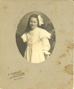 Federation University Historical Collection
Photograph - Photograph - Black and White, S. Fisher Johnson, Edith Pickford (Holmes)
Edith Sarah Pickford was born and raised in Clunes, Victoria. She is the only daughter of John Pickford and Betsey (Robbins) Pickford and sister of Henry Pickford, John Pickford, William Harold Pickford, Horace Pickford DCM, Arthur Pickford and Charles Alexander Pickford. Edith's maternal grandmother was a descendent of Donald Cameron, the first recorded European settler in the Clunes area.The Pickford family's pioneer settler legacy in the Clunes- Glendaruel district is commemorated with a Pickford Road and displays in the Clunes Museum. A collection of Edith's song music was donated to the Clunes Museum by her great grand-daughter in 2023. Edith married a local farmer, Henry Smerdon Holmes from "Sauchieburn" Ascot, Victoria. Henry was a descendant of the family who had inherited their maternal ancestor's, Catherine Coghill (nee Holmes), Ascot - Coghills Creek property. This branch of the Coghill Family descended from the district's pioneer settler, Captain Coghill. Edith and Henry spent all their married life, and raised 4 children Jack [John], Bill [William], [Mary] Elizabeth and David, at Ascot. She was buried in the Coghills Creek Cemetery with her husband, Henry Smerdon Holmes, and their son, David, in 1967. Her children, Bill Holmes and Elizabeth Chatham, and their spouses are buried nearby.Social and historicalMounted black and white photo of a young girl wearing a white dress and ribbon.chatham holmes collection, holmes, pickford -
 Federation University Historical Collection
Book, Stanley B. Hunter, Memoirs of the Geological Survey of Victoria No 7., The Deep Leads of Victoria, 1909
Pink paper covered book by Stanley Hunter, Engineer in Charge of Boring Operations. Contents include tunnelling, deep sinking, the Chiltern Method, the Ballarat Method, Stawell, Ararat, Moyston, Raglan, Wimmera, Landsborough, Avoca, Ballarat West Leads, Berry-Moolort-Loddon Lead System, Clunes, Creswick, Bullarook Affluent, Corinella, Daylesford-Castlemaine Tributary, Majorca-Carisbrook tributary, Huntly, Coliban, Campaspe, Rutherglen., Smythesdale, Durham Lead, Tanjil, Evolution of Mining Machinery, size of claims, Definition of a Deep Lead, Discovery of Gold in Victoria, Geographical Position of Deep Leads, Water in Deep Leads, Methods of Deep Lead Mining, Cost of Deep Lead Mining, Stawell, Ararat, Moyston, Raglan, Wimmera, Landsborough, Avoca, Ballarat West, Berry, Springs Hill, Loddon Valley, Charlotte Plains, , Timor, Burn Creek, Huntly, Colinan, Goulburn, Ovens Valley, Chiltern, Indigo, Morrison's Lead, Plans include: geological Map of Stawell, ararat, Raglan and Landsborough; Kempson's Freehold Mine, Stawell; Geological Map of Beaufort, Avoca, Maryborough, Ballarat west, Berry-Moolort, Loddon, Creswick, Marong, &c; Cardigan Propriety Gold Mine; Working Miners United Gold Mine, Homebush; Hepburn Deep Lead Plan; Madame Berry West Mine; West Berry Consols Mine; Spring Hill and Central Leads; Berry Consols Extended Mine; Loddon Valley Goldfields; Chalk's No 3 Mine; Charlotte Plains Considated Mine; Duke United Mine; Geological Map of Bendigo, Huntley, Campaspe, Malmsbury, Kyneton, trentham, &c; Geological Map of Chiltern, Rutherglan, Eldorado, Beechworth, &c; Chiltern Valley Gold Mine; Wallace Chiltern Valley Consols Mine; great Southern and Chiltern Valley United Mine; great Northern extended Consols; Prentice and Southern deep Leads; Glenfine South Gold Mine; Geological map of Pitfield, Rokewood, Mt Mercer, Ballark, Meredith, &c.; McEvoy Mine; Dargo . . . . . . . . . . . . . . . . . . . . . . . mining, deep leads, squire, tools, gold panning, gold cradle, cradling, puddling, tubbing, mining shaft, shaft sinking, whip, horse whip, whim, horse whim, chalk's no. 1 mine, maryborough, mining cage, shaft, mining trucks, maryborough, washdirt, puddler, tunnelling, deep sinking, chiltern method of working, ballarat method of working, sampling washdirt. gravels, balmoral, mt william, stawell, moyston, great western, ararat, raglan, wimmera valley, landsborough, cardigan, haddon, beaufort, waterloo, avoca, lamplough, caralulup, ballarat west, ballarat, smythesdale, glenfine, illabarook, durham lead, morrison's lead, bullengarook, berry-moolort-loddon system, clunes, creswick, spring hill, bullarook, castlemaine - daylesford, majorca, carisbrook, timor, burnt creek tributary, tarnagulla, marong, rheola, inglewood, huntly, coliban, campaspe, goulburn lead system, ovens valley system, mitta mitta, kiewa valley, tarago, tanjil, moondarra, bogong, dargo high plains -
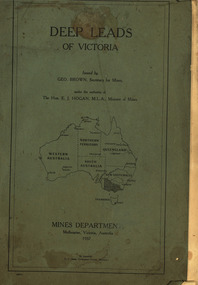 Federation University Historical Collection
Book, Mines Department, Victoria, Deep Leads of Victoria, 1937, 1937
Charcoal green soft covered book of 64 pages. Contents include Ballarat, berry Consols, Canadian Lead, Castlemaine-Daylesford System, Chiltern, Duke of Cornwall Mine, Dyke's Freehold, Frenchman's Lead, Garibaldi Shaft, Glenfine, Guidlford, Hepburn Estate Co., Hepburn Home Paddock, Italian Gully, Henderson's Lead, Langi Logan, Leigh Consols, Sebastopol Plateau; Talbot, Woady Yalloak, A definition of a deep lead, formation of deep leads, water in deep leads, methods of deep lead mining (Tunnelling, Deep sinking, Chiltern method of working, Ballarat method of working), sampling washdirt and gravels, Balmoral, Mt William, Stawell, Moyston, Great Western, Ararat, Raglan, Wimmera Valley, Landsborough, Cardigan, Haddon, Beaufort, Waterloo, Avoca, Lamplough, Caralulup, Ballarat West, Ballarat, Smythesdale, Glenfine, Illabarook, Durham Lead, Morrison's Lead, Bullengarook, Berry-Moolort-Loddon System, Clunes, Creswick, Spring Hill, Bullarook, Castlemaine - Daylesford, Majorca, Carisbrook, Timor, Burnt Creek Tributary, Tarnagulla, Marong, Rheola, Inglewood, Huntly, Coliban, Campaspe, Goulburn Lead System, Ovens Valley System, Mitta Mitts, Kiewa Valley, Tarago, Tanjil, Moondarra, Bogong, Dargo High Plains, glossarymining, deep leads, mines department, squire, leigh consols, chiltern, duke of cornwall mine, dyke's freehold, frenchman's lead, garibaldi shaft, glenfine, guidlford, hepburn estate co., hepburn home paddock, italian gully, henderson's lead, langi logan, sebastopol plateau, talbot, woady yalloak, tunnelling, deep sinking, chiltern method of working, ballarat method of working, sampling washdirt. gravels, balmoral, mt william, stawell, moyston, great western, ararat, raglan, wimmera valley, landsborough, cardigan, haddon, beaufort, waterloo, avoca, lamplough, caralulup, ballarat west, ballarat, smythesdale, illabarook, durham lead, morrison's lead, bullengarook, berry-moolort-loddon system, clunes, creswick, spring hill, bullarook, castlemaine - daylesford, majorca, carisbrook, timor, burnt creek tributary, tarnagulla, marong, rheola, inglewood, huntly, coliban, campaspe, goulburn lead system, ovens valley system, mitta mitta, kiewa valley, tarago, tanjil, moondarra, bogong, dargo high plains -
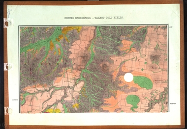 Federation University Historical Collection
Map, Clunes, Mt Greenock, and Talbot Gold Fields, 1883, 1883
A geological plan of the Clunes, Mt Greenock, and Talbot Gold Fields in two parts. .1) This section of the map includes Talbot, Talbot water supply race, Mt Glasgow, Little Green Hill, Middle Hill, Mt Cameron, Ballarat Hill, Bakery Hill, Goodwoman Hill, Scandanavian Lead, Eglinton Swamp, McCallum's Creek, Tullaroop Creek, Dunach, Maryborough Railway, Middle Creek and includes many mines such as Rip Van Winkel, Union Extended, South Greenock, Nicholl's Freehold. .2) This section of the map includes McCallums, Clunes, Green Hill, Mt Beckworth, Mt Gap, Maryborough Reservoir, and includes mines such as Lothair, Bute, Clyde, Clunes Consols, London and Australian, Oriental,clunes, talbot, water supply, railway, geology -
Federation University Historical Collection
Book, Historic Sites Survey: North Central Study Area, 1979, 1979
The North Central Study Area included the Shires of Avoca, Bet Bet, east Loddon, Goulburn, Untly, Kara Kara, Korong, Maldon, Marong, Metcalfe, McIvor, Newstead, Strathfieldsaye, Stawell, Talbot, Clunes, Tullaroop and Waranga. 153 page book with white plastic binding. It is an historic sites survey for the North Central Study Area commissioned by the Land Conservation Council, the Ministry for COnservation and the Australian Heritage Commission. castlemaine, mount alexander goldfield, maldon, percydale, warrenmang, moliagul, tarnagulla, stuart mill, the whipstick, whroo, rushworth, graytown ironbark forest, st arnoaud, new bendigo, landsborough, inglewood, kurting, wedderburn, wehla, kooroora, langham flat, mcintyre, rheola, diamond hill, fosterville, coliban water works, green gully, newstead, muckleford forest, costerfield, graytown, bailieston, waranga irrigaiton system, eucalyptus distillery, mia mia bridge, korokubeal township researce, concegella slate quarry, chewton, fryerstown, kingower, timor, talbot, majorca, carisbroook, clunes, st arnaud, taradale, icomos, dunolly, limestone, castlemaine slate quarry, harcourt granite, taradale railway viaduct, loddon united waterworks trust, gouldburn weir, carisbrook lock-up, history of tree planting in streets, history of public reserves, r.u. nicholls nurseryman, thomas lang, francis moss, ballarat botanical gardens, ballarat school of mines botanical gardens, lake wendouree, victoria park, ballarat, muont holled smith, ballaarat old cemetery planting, eastern oval, ballarat east botanical gardens, ballarat east town hall gardens, eureka stockade reserve, ballarat observatory plantings, yarrowee creek plantings, yarrowee bluestone channels, ballarat woollen mill, band and albion mullock heap, black hill plantings, yarrowee creek channels, canadian creek channel, specimen vale channel, poverty point reserve, union jack reserve buninyong, imperial mine, buninyong, victoria street plantings, bridge mall, sturt street gardens, ballarat avenue of honour plantings, white flat oval plantings, camp street, elms, burnt creek -
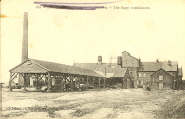 Federation University Historical Collection
Postcard, G. Lelong, The Sugar Manufacture, Somme, France, c1917, c1917
This postcard was sent from France during World War One WW1 to Violet Holmes [mother and aunty of other WW1 soldiers], by the son of a neighbouring Ascot Tourello District Family, the Wrigley Family. Violet inherited "Sauchieburn" an Ascot property on the death of her husband William Holmes in 1914. On her death this property was to be left to their 4 children and administered by a relative till the youngest child turned 27. As young boys, Violet's husband William, and his brother Henry, lived with their Aunt Catherine Coghill and Uncle William Coghill at ‘Sauchieburn’ Ascot. The Coghills had no children of their own. He and his brother Edward started a stock and station business at Clunes. Henry and Violet Holmes subsequently inherited "Sauchieburn" from Catherine (nee Holmes) and William Coghill, direct descendants of the Coghills Creek, Ascot, Tourello pioneer settler Captain William Coghill [Jane Dyer, May 2024] Catherine and her brother Edward Carter Holmes drowned at sea.This is an extract from the Korumburra Times, Wednesday June 6, 1956: The fated travellers wrecked off N.S.W. ‘On May 29th, 1886 in bright moonlight the Ly-e-Moon, the pride of the Australian coastal fleet, broke her back on the treacherous rocks of Green Cape, off the NSW coast. Eighty souls perished within range of the beacon rays of the lighthouse, including representatives of the earliest families ever to settle in Poowong. The passengers. On the main deck, Mr Edward Holmes, a Poowong grazier and former owner of ‘Wombalano’. He had sold this property with the object of going to Queensland and settling there. The proceeds of sale amounting to 1,200 pounds in gold sovereigns were under lock and key in the Purser's Office. Mr Holmes, although advanced in years, had unformed plans to invest his money in some Queensland enterprise. In the meantime he would visit his married daughter and [his] two sons, who had previously settled in Queensland. With him on board was his widowed sister Mrs Coghill who had also accepted an invitation to go north. News of the shipwreck, means of communication being slow, did not reach Korumburra for nearly a week. By then all hope had been abandoned for the missing. Relations and friends thronged the Melbourne shipping office, but the answer was always the same - All passengers unaccounted for were presumed drowned. Black and white postcard of a sugar refinery in The Somme, France. The name of the town has been scrubbed out in purple pencil by a censor during World War One. The back of the card is written on in pencil,Written on back of card: Dear Violet, received photos and letters and thank you for forwarding same. Are we having lovely spell of weather. This morning is quite warm and pleasant. The photo of you all standing in front of your house is a good one and you all look to be getting enough to eat. Mother looks as if she it getting stronger after her severe illness. Your concert party will be broken up through the Vale girls leaving but you should have no difficulty in finding volunteers to fill the ranks. By all of your letters you are all looking forward to the day we return 9as we are). I wouldn't like to bet too much that we would be home by this time next year [ ? ] by the way fritz is fighting lately he would very much like to get [peace?] I think we will give him all he wants this summer. J. Waller was here last night is looking well. With best wished to you all. I am sincerely. [W.Wrigbee? Wrigley]somme, la suererie, chatham family collection, amiens, france, world war 1, postcard, ly-ee-moon, william coghill junior, ascot victoria, pioneers of ascot, shipwreck -
Federation University Historical Collection
Reports, Big Cat sightings (dates), 1989
Research of dated sightngs of Big cats in Victoria from 1868-1989. australian mythical animals collection, david waldron, dse, big cats, panthers pumas, nuggety, gippsland, black cats, tasmanian tiger, marysville, wood's point, thylacine, south gippsland, felid, gippsland big cat, kelvin healey, peter hall, sherbrooke forest, woodside, walaces flat, mountain lion, heyfield, mt taylor, walhalla, mt selma, warrnambool, kyneton, korumburra, canadian forest, grampians, panton hill, beaconsfield, apollo bay, forrest, victoria valley, rapanyup, dargo, inglewood, doncaster east, tidal river, cape bridgewater, walkerville, dooen, st arnaud, lake bung bong, mitta mitta, moliagul, emerald, kinglake, cape otway, dereel, leonard's hill, daylesford, korweinguboora, lal lal, noojee, eltham, lancefield, trentham, daisy hill, tanjil south, wonthaggi, cockatoo, warrenheip, greendale, howqua, lake buchan, melville caves, portland, mt elephant, morwell, navarre, yarram, yandoit, moonambel, maryborough, taravale, coghill's creek, trentham, carisbrook, inglewood, warrenmang, yarragon, creswick, emerald, stawel, clunes, majorca, heathcote, talbot, daylesford, newham, broadford, peter chapple -
 Ballaarat Mechanics' Institute (BMI Ballarat)
Film - Photograph by Herb Richmond. ca 1971, Clunes- Road Bridge over the Creswick Creek
Ballarat History35mm B&W Kodak Plus X Pan Film.ballarat, ballaraat, clunes, bridge, creswick -
 Coal Creek Community Park & Museum
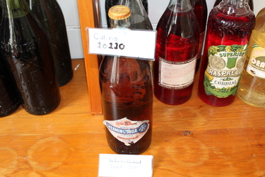
Creaming Soda
Torn Label Red & Yellow Lid Aerated Creaming Soda Refreshing & Invigorations Eberhard & Co Clunes Eberhard & Co Clunes & Talbot -
Clunes Museum
Photograph - PHOTOGRAPHS
Two laminated black and white photographs of groups of men in front of what appears to be at mine site..1 on Reverse; McClean great grandfather was Bates .2 Location "Mile Creek" sawmillbates, afghan -
Clunes Museum
Plan - PLANS, Harry E Sando, Borough of Clunes Contract 96.6 of 1893/4, c1894
Harry E Sando C.E. (Borough Enginee) as at 10th March 1894, this plan also signed by the contactor and witness, both signatures are illegibleColoured drawings on tracing/architects papers, pinned with dress makers pins to stiff paper. Scale 2 feet to 1 inchHeadings on plans; "Ground Plan No.1, Ground Plan No.2, Sections of weirscreswick creek, flood mitigation, weir system -
Clunes Museum
Photograph, 2010
.1 Bridge was damaged and closed for repairs for about 6 months .2 Government bridge is higher and was not damaged.1 colour photograph of flooded creek at the newer bridge, water is hitting the bridge .2 colour photo of Government bridge during the floods, water is below the top of the bridge.1 T. Goldworthy 4th Sept. 2010 about midday .2 T. Goldworthy 4th Sept. 2010 about middaybridges, floods, photograph, goverment bridge -
Clunes Museum
Document - GLENGOWER/GLENDONALD POST OFFICE
... Clunes Museum 36 Fraser Street Clunes goldfields MIDDLE ....1 PHOTOCOPY OF HISTORY OF GLENDONALD POST OFFICE GLENDONALD POST OFFICE WAS OPENED ON 15 JANUARY 1868, AND WAS MADE A RECEIVING OFFICE ON 19 AUGUST 1894. IT WAS CLOSED ON 1 JULY 1917. IT USED BARRED NUMERAL CANCEL 639. GLENDONALD WAS A SMALL RURAL SETTLEMENT LOCATED ON THE INTERSECTION OF TH CRESWICK-CLUNES ROAD AND MINER'S REST-CASTLEMAINE ROAD BETWEEN CLUNES AND CRESWICK. IT WAS SITED AT THE FOOT OF CATTLE STATION HILL. BETWEEN 1874 AND 1885 THE POST OFFICE WAS CONDUCTED BY THE CATTLE STATION STATE SCHOOL HEADMASTER POST OFFICERS AT GLENDONALD WERE: WILLIAM B. LANGDON 1868 E S LANGDON 1868 - 1870 ELISABETH GOOD 1870-1874 ALEXANDER GILLIAN 1874-1885 ARTHUR W BEAN 1885 CHARLOTTE VALINS 1885 THOMAS DUNSTON 1885-1894 ELIZABETH PEARCY 1894-1901 EDWARD PEARCY 1901-1913 NOT KNOWN 1913-1917 .2PHOTOCOPY OF HISTORY OF GLENGOWER/MIDDLE CREEK POST OFFICE GLENGOWER POST OFFICE OPENED ON 13 JANUARY 1868 AS MIDDLE CREEK. ITS NAME WAS CHANGED ON 1 JUNE 1881, WHEN IT BECAME A RECEIVING OFFICE. A MIDDLE CREEK POST OFFICE WAS OPENED NEAR ARARAT IN 1881 AND THE POSTMASTER GENERAL HAD A POLICY OF NOT HAVING POST OFFICES HAVING THE SAME NAME. GLENGOWER WAS UPGRADED TO POST OFFICE ON 1 JULY 1927, IT CLOSED ON 30 JUNE 1952 BARRED NUMERAL CANCEL 632 WAS USED AT GLENGOWER POST OFFICERS AT GLENGOWER WERE: S IRWIN 1868-1869 DONALD FRASER 1869-1871 JOHN KEMP 1871-1873 JOHN NEWTON 1873-1876 W POTTER 1876-1887 ANNIE MCIVOR 1887-1892 JESSIE MCIVOR 1892-?? UNKNOWSN ????-1927 DJ FRASER 1927-1939 JAMES CAMPBELL 1939-1952middle creek post office, glengower post office, glendonald post office -
Clunes Museum
Work on paper - FAMILY HISTORY BENJAMIN WHITE
BENJAMIN AND SARAH WHITE ARE RECORDED IN "SOUTH AUSTRALIANS 1836-1885" BOOK TWO.DESMA FAY NICHOLSON OF 160 FRANCIS ST RICHMOND NSW PROVIDED THE INFORMATION FOR THE BOOK. DESMA IS A DESCENDENT OF JOHN WHITE, FIFTH AND YOUNGEST SON OF BENJAMIN WHITE BENJAMIN WHITE PARENTS BENJAMIN AND JANE (NEE LOWDEN- SHOULD BE SOWDEN) BORN 1819 CAMBORNE, CORNWALL DIED JAN 1874 VICTORIA, BURIED IN CRESWICK ARRIVED SA 29/10/1847 FROM ENGLAND ON DUCHESS OF NORTHUMBERLAND DEPARTED SA C. 1852 FOR VICTORIA OVERLAND OCCUPATION MINER AND SECTON RESIDENCE: KAPUNDA ALLENS CREEK SA RELIGION: WESLEYAN HE MARRIED SARAH (SALLY) BAILEY ON 02/08/1845 IN CAMBORNE ENGLAND, SHE DIED 12/08/1891 IN CRESWICK CHILDREN: SARAH ANNE WILLIAMS 07/09/1845 TO 18/06/1890 ELIZABETH ORRINGE 22/02/1847 TO 16/10/1920 BENJAMIN 22/04/1849 TO 19/02/1889 HARRIET 29/08/1850 TO 15/05/1851 WILLIAM BAILEY 22/10/1851 TO 14/03/1916 JOSEPH 20/11/1853 TO 17/05/1910 THOMAS HENRY 15/05/1855 TO 15/08/1917 JOHN 14/04/1857 TO 27/02/1935 HARRIET 17/01/1860 TO 14/06/1863 DECIMA JANE CHEGWYN 04/01/1862 TO 28/02/1940 EMILY WILSON 07/03/1864 TO 19/08/1937 BENJAMIN WHITE MARRIED SARAH BAILEY IN CORNWALL IN SEPTEMBER 1845, JUST ONE MONTH BEFORE THE BIRTH OF THEIR FIRST CHILD SARAH ANN. SECOND CHILD ELIZABETH WAS BORN IN MARCH 1847 JUST SIX MONTHS BEFORE THE FAMILY SAILED FOR SOUTH AUSTRALIA ON THE NORTHUMBERLAND. THE MANNING INDEX OF SOUTH AUSTRALIAN HISTORY REC9ORDS THAT BENJAMIN WHITE WAS RESPONSIBLE FOR "CREATING" THE ALLEN CREEK VILLAGE 5 KM NORTHWEST OF KAPUNDA C. 1849. CERTAINLY AT ONE STAGE BENJAMIN HAD A CONSIDERABLE LAND HOLDING ADJACENT TO ALLEN'S CREEK VAL LAWRENCE SUGGESTS THAT THE WHITE FAMILY TRAVELLED BY SEA FROM SA TO VICTORIA, NOT OVERLAND AS SUGESTED BY DESMA NICHOLSON IN "SOUTH AUSTRALIANS 1836-1885 ACCORDING TO CRSWICK HOSPITAL RECORDS BENJAMIN WHITE WAS ADMITTED JUNE 27 1873 (AGE 49 MARRIED, GRAVEDIGGER AT CRESWICK, BORN IN ENGLAND, WESLEYAN) AND LEFT HOSPITAL JULY 14 1873. A CHRONICALLY ILL CONDITION WAS RELIEVED. BENJAMIN WHITE DIED DECEMBER 22, 1873. A SPECIAL CHURCH SERMON WAS CARRIED OUT ON SUNDAY JANUARY 43 1874benjamin white, sarah white, sarah bailey -
Clunes Museum
Photograph
COPY OF PHOTOGRAPH OF FLOOD ON CRESWICK CREEK AT SUSPENSION BRIDGE BEHIND KEEBLE'S 8/9/1909 TALBOT RD CLUNES. IT WAS THIS BRIDGE THAT MR. WATSON WAS SO NEARLY CARRIED DOWN WITH THE RUSHING WATERS. HE WAS STANDING ON PART OF IT, WHEN IT BROKE AWAY AND HE MANAGED TO CLING TO TO THE REMAINSsuspension bridge flood, flood creswick creek, 1909 flood