Showing 212 items matching "county of bourke"
-
 Ringwood and District Historical Society
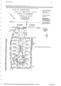
Document - Subdivision Plan, LP76792 Part of Crown Portions 19 & 20A, Parish of Ringwood, County of Bourke, Vol 8382 Fol 140 - 1967
... , County of Bourke, Vol 8382 Fol 140 - 1967... of Crown Portions 19 & 20A, Parish of Ringwood, County of Bourke ...LANDATA Land Victoria plan printout dated 2010Map includes Rupert Street and Prospect Court, Ringwood. -
 Ringwood and District Historical Society
Document, Plan of Subdivision - Part of Crown Portion 5, Parish of Ringwood, County of Bourke - (Undated)
... Ringwood, County of Bourke - (Undated)...., Parish of Ringwood, County of Bourke - (Undated). Document ...Map showing layout of 4 numbered allotments coloured red and land coloured blue appropriated or set aside for drainage and sewerage puposes.Map includes Nelson Street and Ringwood Street, Ringwood, Vic. -
 University of Melbourne, Burnley Campus Archives
Plan - Photocopy, County [of Bourke], c.1930
... County [of Bourke].... County [of Bourke] Plan Photocopy ...Given to Archives by Emma Ferguson and Jo van Berkel who used it in preparation of their 1994 thesis on the history of the Burnley Gardens. Photocopy of a plan depicting Burnley College as it was in the 1930's. It shows the Pavilion and surrounding gardens, coops and yards, various small outbuildings. Shows the contours of the land in the northern section of the property bordering Swan St. Some additions and comments have been added to original document, mainly to do with sewerage and water supplyburnley college, pavilion, emma ferguson, jo van berkel, orchard, water supply -
 Ringwood and District Historical Society
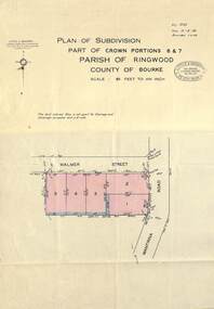
Map - Plan of Subdivision, Part of Crown Portions 6 & 7, Parish of Ringwood, County of Bourke - 1960
... Part of Crown Portions 6 & 7, Parish of Ringwood, County of.... Part of Crown Portions 6 & 7, Parish of Ringwood, County ...Copy of land title map on light cardboard backing showing layout and size of 5 residential allotments in Walmer Street and Wantirna Road, Ringwood, Victoria.Ref. 3725 Date 15-8-1960 Amended 7-9-1960. Little & Brosnan, Licensed Surveyors & Engineers, 422 Little Collins Street, Melbourne. Telephone MU 5111. -
 Whitehorse Historical Society Inc.
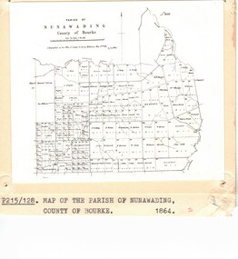
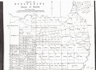
Photograph - Parish Map, Parish of Nunawading
... County of Bourke..., County of Bourke, 1864. Copy also at ND880, Map Drawer.... Mitcham melbourne Parish of Nunawading County of Bourke Maps Black ...Black and white photo of map of the Parish of Nunawading, County of Bourke, 1864. Copy also at ND880, Map Drawer.parish of nunawading, county of bourke, maps -
 City of Moorabbin Historical Society (Operating the Box Cottage Museum)
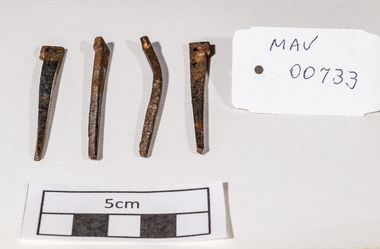
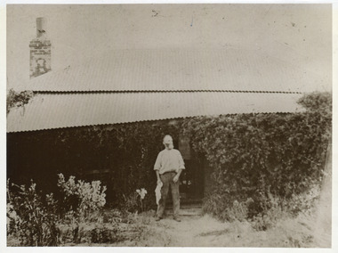
Building Equipment, original hand made nails Box Cottage c 1850, c1850
... Parish of Moorabbin, County of Bourke, Victoria, Australia ...The original small, pioneer cottage was built in the late 1840s to early1850s, by an unknown pioneer. It was located on part of a 30 Acre allotment that was originally part of Henry Dendy’s Special Survey granted in 1841. The doors and window sashes, (made of red deal joinery timber), as well as the brass locks and fittings, are from the original cottage, and were imported from England.The fire-place bricks are from the original cottage, and are sun-dried, (not kiln fired), and are hand-made. Convict marks can be seen on two bricks.There is a small display of external cladding shingles from the original pioneer cottage. These shingles were hand-split, and most likely made from locally collected timber The nails included in this display were used to fasten the shingles on the original cottage, and are also hand-made. The enamel nameplate, “Colonial”, on the wall of the cottage, was the name chosen for the original pioneer cottage when a later owner, Mr August Rietman and wife Frieda leased the property in around 1917. August purchased the property 1935 for 1200 Pounds approximately and resided there until 1953. In 1974 Mr Lewis, a timber specialist, found the dilapidated building on property he had recently purchased in Jasper Rd and suggested it be reconstructed and relocated. Moorabbin Council agreed and the Cottage was rebuilt just about 250 metres from its original site. The cost of the rebuild was met by 'Victoria's 150th Committee', plus a small grant from the City of Moorabbin, and Mr Laurie Lewis donated much of the timber for the reconstruction. Theses 4 iron nails were hand made by an early settler c1850, using iron, forge and anvil, for the construction of the original Box Cottage 4 hand made iron nails c1850 used in building the original pioneer cottage now known as Box Cottage Museumbox william, box elizabeth, brighton, henry dendy special survey 1841, early settlers, pioneers, moorabbin, box cottage museum, nails, building equuipment, forges, anvils, blacksmiths -
 Whitehorse Historical Society Inc.
Document, Plan of Parish of Nunawading, 01/05/1864
... county of bourke...Copy of plan of Parish of Nunawading, County of Bourke... of Parish of Nunawading, County of Bourke, lithographed ...Copy of plan of Parish of NunawadingCopy of plan of Parish of Nunawading, County of Bourke, lithographed at the Office of Lands and Survey, Melbourne, 13th May, 1864 showing boundaries of Koonung, Mullum Mullum and Dandenong Creeks.Copy of plan of Parish of Nunawadingland subdivision, parish of nunawading, county of bourke, elgars special survey, koonung creek, mullum mullum creek, dandenong creek -
 Ballan Shire Historical Society
Map - Map. Moorarbool East and West, Country Lands in the Parishes of Moorarbool East and Moorarbool West. Counties of Bourke and Grant
... County of Bourke..., north of Ballan in the Counties of Bourke and Grant...., north of Ballan in the Counties of Bourke and Grant. moorarbool ...This is a map of "Country Lands" around the Werribee River, north of Ballan in the Counties of Bourke and Grant.A relatively small map, paper on a material backing. Shows topographical features, roads and property divisions. Scale of forty chains to one inch. The map is dated March 31st, 1859.There is a small inscription under the chain scale that reads "No 58/364 John Phillips ? Survey 1st August 1858". The name Dugald McPherson is hand written on one of the blocks of land.moorarbool west, moorarbool east, dugald mcpherson, county of bourke, county of grant, werribee river, ballan -
 City of Moorabbin Historical Society (Operating the Box Cottage Museum)
Photograph, Black & White, John Box 1841-1913 and Document re Will, a) c1900 b) 1928
... , mckinnon, parish of moorabbin, city of moorabbin, county of bourke... gardens in Parish of Moorabbin, County of Bourke... in Parish of Moorabbin, County of Bourke John Box was a pioneer ...John Box 1841 - 1913 was a member of the George Box family who migrated from Sussex England 1855 and established market gardens in Parish of Moorabbin, County of BourkeJohn Box was a pioneer settler 1855 in Moorabbin Shire, County of Bourke and established a market garden and raised his family.a)Black & White photograph of John Box standing at his home in North Road East Bentleigh c1900 b) Document - letter regarding the Estate of John Box 1928a) nil b) as printedbox george,b 1808, box john1841 - 1913, box william, box elizabeth smith j l; smith mary ann, stanley helen, smith vic, chaff cutter, horse drawn carts, early settlers, bentleigh, mckinnon, parish of moorabbin, city of moorabbin, county of bourke, moorabbin roads board, shire of moorabbin, henry dendy's special survey 1841, were j.b.; bent thomas, o'shannassy john, king richard, charman stephen, highett william, ormond francis, maynard dennis, market gardeners, vineyards, orchards -
 City of Moorabbin Historical Society (Operating the Box Cottage Museum)
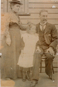
Photograph, Black & White, Adelaide Bleazby, Frank Box, Daisy c1900, c1900
... , bentleigh, mckinnon, parish of moorabbin, city of moorabbin, county... of Moorabbin, County of Bourke. Frank married Adelaide Bleazby in 1873... 1841 Brighton', Parish of Moorabbin, County of Bourke. Frank ...Frank Box was descendant of the Box family who migrated from Sussex England c 1850 and established market gardens in the area of Henry Dendy's Special Survey 1841 Brighton', Parish of Moorabbin, County of Bourke. Frank married Adelaide Bleazby in 1873 and they are shown here with their daughter, Daisy , at Kilgour Street Geelong Victoria c1900The Box family were pioneer settlers in the Parish of Moorabbin, County of Bourke c 1850 in the area of Henry Dendy's 'Special Survey Brighton 1841'. They established market gardens and raised their children.Faded Black & White photograph of Adelaide Bleazby, Frank Box and daughter Daisy at Geelong c1900Back handwritten information unsignedbox george, box william, box elizabeth, box francis, box cottage museum ormond, city of moorabbin historical society, bleazby adelaide 1873, box frank smith j l; smith mary ann, stanley helen, smith vic, chaff cutter, horse drawn carts, toll gates brighton, motor cars 1900, steam engines, early settlers, bentleigh, mckinnon, parish of moorabbin, city of moorabbin, county of bourke, moorabbin roads board, shire of moorabbin, henry dendy's special survey 1841, were j.b.; bent thomas, o'shannassy john, king richard, charman stephen, highett william, ormond francis, maynard dennis, market gardeners, vineyards, orchards -
 City of Moorabbin Historical Society (Operating the Box Cottage Museum)
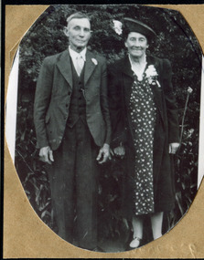
Photograph, Alfred Amos , Gertrude Emma Box 1941, c1941
... moorabbin, county of bourke, moorabbin roads board, shire of..., County of Bourke. William's parents, George & Mary Box followed... Brighton 1841' in the Parish of Moorabbin, County of Bourke ...William and Elizabeth Box migrated from Sussex England c1850 and established a market garden in the area of Henry Dendy's 'Special Survey Brighton 1841' in the Parish of Moorabbin, County of Bourke. William's parents, George & Mary Box followed in 1856 bringing 6 of their 10 children and joined William in East Brighton ( Bentleigh) Gertrude Emma Box is a descendant of this family.The Box family were pioneer settlers in the area of 'Henry Dendy's Special Survey 1841' Brighton and established market gardens .Black & White photograph of Alfred Amos and Emma Gertrude Box c1941box william, box mary nee cripps, box elizabeth avis, box george b 1808, box gertrude emma, amos alfred, smith j l; smith mary ann, stanley helen, smith vic, s horse drawn carts,, early settlers, bentleigh, mckinnon, parish of moorabbin, city of moorabbin, county of bourke, moorabbin roads board, shire of moorabbin, henry dendy's special survey 1841, were j.b.; bent thomas, o'shannassy john, king richard, charman stephen, highett william, ormond francis, maynard dennis, market gardeners, vineyards, orchards -
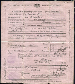 City of Moorabbin Historical Society (Operating the Box Cottage Museum)
Document, Certificate of Discharge 1st AIF Alonzo Sheldrake Box 22/5/1917 2pp, 1917
... , bentleigh, mckinnon, parish of moorabbin, city of moorabbin, county... Brighton, in the Parish of Moorabbin County of Bourke. Alonzo..., in the Parish of Moorabbin County of Bourke. Alonzo was a pavier, who ...Alonzo Sheldrake Box 1851- 1958 was the nephew of William and Elizabeth Box who migrated from Sussex England 1850 and established a market garden in the area of Henry Dendy's 'Special Survey 1841 Brighton, in the Parish of Moorabbin County of Bourke. Alonzo was a pavier, who laid blue stone for drains, and enlisted in 1914 to serve in Gallipoli, and France . He returned to Bentleigh 1917 and married Mary Louisa Closter 1918 . Alonzo Box was a member of the pioneering Box family who emigrated from Sussex England 1850 and established market gardens in the the Parish of Moorabbin, County of Bourke. Alonzo Box enlisted in the 1st AIF in 1914 and served in Gallipoli and France. Document, Certificate of Discharge No. 1054 Australian Imperial Expeditionary Force 1917, Alonzo Sheldrake Box Sergeant as Printed by Government Printer box george b 1808, box william, box elizabeth avis, box alonzo sheldrake, closter mary louisa, wedding dress box cottage museum, paviers, road building, world war 1 1914-1918, gallipoli, somme battles, smith j l; smith mary ann, stanley helen, smith vic, chaff cutter, horse drawn carts, early settlers, bentleigh, mckinnon, parish of moorabbin, city of moorabbin, county of bourke, moorabbin roads board, shire of moorabbin, henry dendy's special survey 1841, were j.b.; bent thomas, o'shannassy john, king richard, charman stephen, highett william, ormond francis, maynard dennis, market gardeners, vineyards, orchards -
Whitehorse Historical Society Inc.
Map, Parish of Nunawading, 1939
... Parish of Nunawading, County of Bourke, Blackburn..., Parish of Nunawading, County of Bourke, Blackburn Wellington... Mitcham melbourne Parish of Nunawading, County of Bourke ...Plan of subdivision part of crown portions 81, 82 and 89,Plan of subdivision part of crown portions 81, 82 and 89, Parish of Nunawading, County of Bourke, Blackburn Wellington Avenue amended from Stanley RoadPlan of subdivision part of crown portions 81, 82 and 89, street names, parish of nunawading, blackburn road, blackburn, wellington avenue, blackburn, wolseley crescent, blackburn, gordon crescent, blackburn, clarke street, blackburn, central road, blackburn -
Federation University Historical Collection
Document, License under Section 19 of "The Land Act 1869", 1875
... county of bourke.... The area was in the County of Bourke, Parish of Blackwood. The area... was in the County of Bourke, Parish of Blackwood. The area concerned ...Full license and authority to enter and occupy Crown Land outlined was given to James Cowan. This was for a period of three years and subjected to conditions outlined on the document. The area was in the County of Bourke, Parish of Blackwood. The area concerned is located on the Lerderderg River in the Wombat State Forest. The fee for occupation was to be paid in advance by half-yearly payments to the Land Officer at Ballarat. The document signed on 1 July 1875 by William F Stawell, Acting Governor of Victoria.Thick pale blue paper. Hand written in ink Hand drawn map of land in questionDated 1 July 1875 Signed William F Stawelllicence, license, crown land, james cowan, county of bourke, parish of blackwood, lerderberg river, wombat state forest, william foster stawell, acting governor, land officer, ballarat -
 Greensborough Historical Society
Poster - Planning Document, Shire of Diamond Valley et al, Subdivision Plan # 1044 - Parish of Nillumbik, County Bourke, Crown Allotment B Section 12, Eltham North, 1981-1987
... Subdivision Plan # 1044 - Parish of Nillumbik, County...Subdivision Plan # 1044 - Parish of Nillumbik, County.... Subdivision Plan # 1044 - Parish of Nillumbik, County Bourke, Crown ...Subdivision Plan # 1044 - Parish of Nillumbik, County Bourke, Crown Allotment B Section 12, Eltham North. This subdivision plan includes Weidlich Road and St Clems Street. The developer for this subdivision is Taunton Developments and the Surveyors are Fisher Cleeland Turner & Dwyer Vic, Surveyors and Engineers.An example of hard copy subdivision plans from the Greensborough area. Mainly from the Shire of Diamond Valley era (1964-1994).Plan (single sided) mounted on heavy card. Stamped and handwritten Council permissions, dates and other details. subdivision plans, shire of diamond valley, taunton developments -
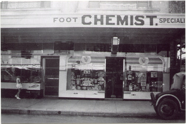 City of Moorabbin Historical Society (Operating the Box Cottage Museum)
Photograph, Black & White, Mr Moore's 1st Chemist Shop Centre Road, Bentleigh c1930, c1930
... county of bourke...Early settlers in the Parish of Moorabbin, County of Bourke... settlers in the Parish of Moorabbin, County of Bourke, established ...Early settlers in the Parish of Moorabbin, County of Bourke, established market gardens and farms in the area of Henry Dendy's Special Survey 1841 Brighton. Small communities grew near Churches & Schools and shops and businesses were established. Following the opening of the Railway line from Caulfield to Mordialloc 1881 the shops and business moved from the Tucker Road /Centre Road ( East Brighton ) East Bentleigh area to be close to the transport. Shops, businesses and housing developed along Centre Road between Thomas Street and Jasper Road. Mr Arthur Moore established his 1st shop in 395 Centre Road c1930 and later moved along the road to a site next to Coles Variety Store.Following the opening of the Railway line from Caulfield to Mordialloc 1881 the shops and business moved from the Tucker Road /Centre Road East Bentleigh area to be close to the transport. Shops, businesses and housing developed along Centre Road between Thomas Street and Jasper Road. Mr Moore established his 1st shop in 395 Centre Road c1930 and later moved along the road to a site next to Coles Variety Store.Black & White photograph of Mr Arthur Moore's 1st Chemist Shop, 384 Centre Road Bentleigh c 1930 back Handwritten information unsignedbentleigh shopping centre c1930, east brighton, railway line caulfield -mordialloc 1881, chemists, pharmacy, moore's moorabbin shire, smith j l, smith mary ann, stanley helen, smith vic, smith harry redvers, chaff cutter, horse drawn carts, toll gates brighton, motor cars 1900, steam engines, early settlers, bentleigh, mckinnon, parish of moorabbin, city of moorabbin, county of bourke, moorabbin roads board, shire of moorabbin, henry dendy's special survey 1841, were j.b., bent thomas, o'shannassy john, king richard, charman stephen, highett william, ormond francis, maynard dennis, market gardeners, vineyards, orchards -
 Greensborough Historical Society
Poster - Planning Document, Shire of Diamond Valley et al, Subdivision Plan # 1026 - Parish of Nillumbik, County Bourke, Crown Allotment B Section 12, Eltham North, 1981-1984
... Subdivision Plan # 1026 - Parish of Nillumbik, County...Subdivision Plan # 1026 - Parish of Nillumbik, County..., County Bourke, Crown Allotment B Section 12, Eltham North. Poster ...Subdivision Plan # 1026 - Parish of Nillumbik, County Bourke, Crown Allotment B Section 12, Eltham North. This subdivision plan includes Ryans Road (also known as Government Road) and St Clems Street. The developer for this subdivision is Taunton Developments and the Surveyors are Fisher Cleeland Turner & Dwyer Vic, Surveyors and Engineers.An example of hard copy subdivision plans from the Greensborough area. Mainly from the Shire of Diamond Valley era (1964-1994).Plan (single sided) mounted on heavy card. Stamped and handwritten Council permissions, dates and other details. subdivision plans, shire of diamond valley, taunton developments -
City of Moorabbin Historical Society (Operating the Box Cottage Museum)
Document,leaflet 'Brief History of the City of Moorabbin 1850 - 1934', 2015
... city of moorabbin, county of bourke, moorabbin roads board..., Henry Dendy's Special Survey 1841 in County of Bourke ; J.B Were... Special Survey 1841 in County of Bourke ; J.B Were, land agent ...2015 CMHS members D. Maynard. Fran & Holger Bader compiled this Leaflet to provide a condensed information Leaflet about the origin and development of the area known as 'The City of Moorabbin' from 1850 -1994. Topics ; Aboriginal Bunurrung people, Henry Dendy's Special Survey 1841 in County of Bourke ; J.B Were, land agent, Pastoralists/ Squatters John O'Shannassy, Richard & John King, Moysey Family, Alexander MacDonald; Parish of Moorabbin Land Developers 1850 J.Holloway, A. Balcombe, D.Wickham, S. Charman, Keys Family; Road District of Moorabbin 1862 - 1870; Shire of Moorabbin 1871 - 1934; City of Moorabbin 1934 - 94; Amalgamation of Councils 1994 divided the City of Moorabbin between the Cities of Glen Eira, Bayside, Kingston and Monash; Origin of suburb names,This Leaflet was compiled in 2015 to provide a condensed history of the area known as 'The City of Moorabbin' for visitors , schools and local community1 x A4 printed both sides, black and white, folded x 3page 1 'BRIEF HISTORY OF THE CITY OF MOORABBIN' ; CITY OF MOORABBIN /1934-1994 page 2 'CITY OF MOORABBIN / 1934 - 94 city of moorabbin, county of bourke, moorabbin roads board, parish of moorabbin, shire of moorabbin, henry dendy's special survey 1841, were j.b.; bent thomas, o'shannassy john, king richard, charman s, highett william, ormond francis, maynard dennis, -
 Greensborough Historical Society
Poster - Planning Document, Shire of Diamond Valley et al, Subdivision Plan # 1018 - Parish of Nillumbik, County Bourke, Crown Allotment 4 Section 15, and Crown Allotment B Section 12, Eltham North, 1981-1982
... Subdivision Plan # 1018 - Parish of Nillumbik, County...Subdivision Plan # 1018 - Parish of Nillumbik, County.... Subdivision Plan # 1018 - Parish of Nillumbik, County Bourke, Crown ...Subdivision Plan # 1018 - Parish of Nillumbik, County Bourke, Crown Allotment 4 Section 15, and Crown Allotment B Section 12, Eltham North. This subdivision plan includes Ryans Road (also known as Government Road) and St Clems Street. The developer for this subdivision is Taunton Developments and the Surveyors are Fisher Cleeland Turner & Dwyer Vic, Surveyors and Engineers.An example of hard copy subdivision plans from the Greensborough area. Mainly from the Shire of Diamond Valley era (1964-1994).Plan (single sided) mounted on heavy card. Stamped and handwritten Council permissions, dates and other details. subdivision plans, shire of diamond valley, taunton developments -
Whitehorse Historical Society Inc.
Document, Certificate of Title, 1922, 1933
... allotment 1270, Parish of Nunawading, County of Bourke 1922 vol... of Nunawading, County of Bourke 1922 vol 4583, fol 916577 also rates... of crown allotment 1270, Parish of Nunawading, County of Bourke ...Certificate of Title, Margaret Kennedy.Certificate of Title, Margaret Kennedy. Lots 100, 101 & 102, subdivision 1968, part of crown allotment 1270, Parish of Nunawading, County of Bourke 1922 vol 4583, fol 916577 also rates enforcement of charge, 1933.Certificate of Title, Margaret Kennedy.land titles, shire of blackburn and mitcham, kennedy, margaret, mcdowall street, mitcham -
Whitehorse Historical Society Inc.
Document, Certificate of Title, 1915, 1933
... , Parish of Nunawading, County of Bourke 1915. Vol 3882, fol..., County of Bourke 1915. Vol 3882, fol 776385 also correspondence... allotment 1270, Parish of Nunawading, County of Bourke 1915. Vol ...Certificate of Title, Frederick William GibbonsCertificate of Title, Frederick William Gibbons, Lot 88, Subdivision 1968, part of crown allotment 1270, Parish of Nunawading, County of Bourke 1915. Vol 3882, fol 776385 also correspondence re rates, enforcement of charge, 1933.Certificate of Title, Frederick William Gibbonsland titles, shire of blackburn and mitcham, gibbons, frederick william, shire of nunawading, burnett street, mitcham, gort road, mitcham -
Whitehorse Historical Society Inc.
Map, Parish of Nunawading, 1853
... Note on verso: Parish of Nunawading, County of Bourke... and named. Note on verso: Parish of Nunawading, County of Bourke..., County of Bourke. Gardiners Creek, Ballyshanassey Township ...Photocopy of manuscript map with allotments numbered and named.Photocopy of manuscript map with allotments numbered and named. Note on verso: Parish of Nunawading, County of Bourke. Gardiners Creek, Ballyshanassey Township, surveyed by H. Parmein, Surveyor General's office, Nov 30th 1853 [enlargement of ND2801, no list of corner references]Photocopy of manuscript map with allotments numbered and named. maps, gardiners creek, ballyshanassy, burwood east, parmein, h -
Whitehorse Historical Society Inc.
Map, The Parish of Nunawading, 1853
... Note on verso: The Parish of Nunawading in the County... in the County of Bourke; lithographed at the Surveyor General's office... in the County of Bourke; lithographed at the Surveyor General's office ...Photocopy of manuscript plan with allotments numbered and some named.Photocopy of manuscript plan with allotments numbered and some named. Note on verso: The Parish of Nunawading in the County of Bourke; lithographed at the Surveyor General's office by J.Jones Jan 18th 1853. Endorsed Sale Plan 271. Dray tracks, water holes and terrain indicated.Photocopy of manuscript plan with allotments numbered and some named. land subdivision, maps, parish of nunawading, jones, j -
Whitehorse Historical Society Inc.
Document, Certificate of Title, 1921, 1933
... , Parish of Nunawading, County of Bourke 1922. Vol 4474, fol 894734..., Parish of Nunawading, County of Bourke 1922. Vol 4474, fol 894734... 89 & 90, Parish of Nunawading, County of Bourke 1922. Vol ...Certificate of Title, Charles Norris and William Richard Norris.Certificate of Title, Charles Norris and William Richard Norris. Lot 6 Subdivision 4894, part of crown portions 89 & 90, Parish of Nunawading, County of Bourke 1922. Vol 4474, fol 894734 also correspondence re rates, enforcement of charge 1933.Certificate of Title, Charles Norris and William Richard Norris.land titles, shire of blackburn and mitcham, norris, charles, norris, william richard, blackburn road, blackburn -
Whitehorse Historical Society Inc.
Document, Certificate of Title, 1928, 1933-1934
... Parish of Nunawading, County of Bourke 1928. Vol 5406 fol..., County of Bourke 1928. Vol 5406 fol 10881070 1928, Agnew... portion 97 Parish of Nunawading, County of Bourke 1928. Vol 5406 ...Certificate of Title, Nanny Schifferdecker.Certificate of Title, Nanny Schifferdecker. Lots 44, 45,56 & 57 subdivision 3360 Crown portion 97 Parish of Nunawading, County of Bourke 1928. Vol 5406 fol 10881070 1928, Agnew and Craig Streets. Also correspondence re rates enforcement charge 1933.Certificate of Title, Nanny Schifferdecker. land titles, shire of blackburn and mitcham, schifferdecker, hanny, craig street, blackburn south, agnew street, blackburn south -
Whitehorse Historical Society Inc.
Map, Plan of special survey selected by H. Elgar Esq, 1841
... . Elgar Esq in the Parishes of Boroondara and Nunawading, County... in the Parishes of Boroondara and Nunawading, County of Bourke. Surveyed..., County of Bourke. Surveyed by T.H. Nott (?Sydney) 31 May 1841 ...Photocopy of plan and listing of corner stakes.Photocopy of plan and listing of corner stakes. Note on verso: Plan of special survey selected by H. Elgar Esq in the Parishes of Boroondara and Nunawading, County of Bourke. Surveyed by T.H. Nott (?Sydney) 31 May 1841. Boroondara Special Survey B.17, with attached descriptive note by T. H. Nott.Photocopy of plan and listing of corner stakes. maps, parish of boroondara, parish of nunawading, elgar, h, nott, t.h. -
Whitehorse Historical Society Inc.
Document, Certificate of Title, 1917 - 1933
... , Parish of Nunawading, County of Bourke with a right of carriage... 602, Part of Crown Allotment 127, Parish of Nunawading, County... Allotment 127, Parish of Nunawading, County of Bourke with a right ...Certificate of Title, Harrison Rotherham of 'Thulecroft', Albion Street, Surrey Hills, Merchant.Certificate of Title, Harrison Rotherham of 'Thulecroft', Albion Street, Surrey Hills, Merchant. Lots 61 & 62, subdivision 602, Part of Crown Allotment 127, Parish of Nunawading, County of Bourke with a right of carriage way over Harrison and Burnett streets, 1917. Vol 4046, Fol 809049. Also correspondence re rates, enforcement of charge, 1933.Certificate of Title, Harrison Rotherham of 'Thulecroft', Albion Street, Surrey Hills, Merchant.land titles, shire of nunawading, shire of blackburn and mitcham, rotherham, harrison, harrison street, mitcham, burnett street, mitcham -
Whitehorse Historical Society Inc.
Document, Certificate of Title, 1910, 1928, 1933
... Part of Crown Allotment 118A, Parish of Nunawading, County... Allotment 118A, Parish of Nunawading, County of Bourke, 1910. Vol... of Nunawading, County of Bourke, 1910. Vol 3462 fol 692315 also ...Certificate of Title, Albert Edward Ruglen.Certificate of Title, Albert Edward Ruglen. Part of Crown Allotment 118A, Parish of Nunawading, County of Bourke, 1910. Vol 3462 fol 692315 also correspondence re rate enforcement of charge. Another certificate of title for the same person, subdivision 12279, vol 5389 fol 1077705 1928 and rates - enforcement of charge 1933.Certificate of Title, Albert Edward Ruglen.ruglen, albert edward -
Whitehorse Historical Society Inc.
Article, Ballyshanassy
... Paragraph about Ballyshanassy (County of Bourke... Paragraph about Ballyshanassy (County of Bourke) in the Victorian ...Paragraph about Ballyshanassy (County of Bourke) in the Victorian GazetteerParagraph about Ballyshanassy (County of Bourke) in the Victorian GazetteerParagraph about Ballyshanassy (County of Bourke) in the Victorian Gazetteerballyshanassy shire of nunawading, bourke -
Glen Eira Historical Society
Plan - Pascoe Avenue, 26, Bentleigh
... County of Bourke... County of Bourke Maps Brick Houses National Trustees Co ...Document detailing two valuations by National Trustees Co of the property at 26 Pascoe Ave, Bentleigh, the first valuation is dated 14/07/1954 and the second dated 19/07/1957. Included are handdrawn plans, handwritten notes and typed valuations listing values of architectural features, and correspondence from National Trustees Co. for both 1954 and 1957. The 1954 documents were clearly used in the 1957 valuation.pascoe ave, land subdivisions, land values, bentleigh, pergolas, architectural features, parish of moorabbin, plans, architectural styles, county of bourke, maps, brick houses, national trustees co, illustrations, dendy’s crown special survey