Showing 527 items
matching land owners
-
 Whitehorse Historical Society Inc.
Document, South Riding
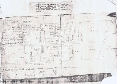
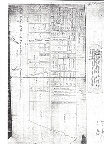
... Plan showing owners of land in the South Riding... riding arundale w h. arnold & co. Plan showing owners of land ...Plan showing owners of land in the South Riding of the Shire of NunawadingPlan showing owners of land in the South Riding of the Shire of Nunawading 1888. South Boundary Road is now Highbury RoadPlan showing owners of land in the South Riding of the Shire of Nunawading land subdivision, shire of nunawading. centre riding, dandenong creek, fulton, dr, shire of nunawading. south riding, arundale, w, h. arnold & co. -
 Whitehorse Historical Society Inc.
Map, Shire of Nunawading 1888
... Plan showing owners of land in the South Riding... showing owners of land in the South Riding of the Shire ...Plan showing owners of land in the South Riding of the Shire of Nunawading, 1888. South Boundary Road is now Highbury Road.shire of nunawading. south riding, south boundary road, burwood east, highbury road, springvale road, mahoneys road, forest hill, holland road, blackburn south, burwood highway -
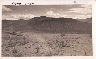
 Kiewa Valley Historical Society
Black and white photograph of farmland, Kiewa, 25/8/38, circa 1938
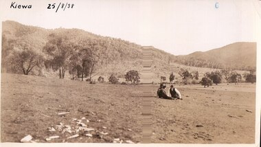
... for grazing, and the land was eventually acquired from the local land..., and the land was eventually acquired from the local land owners ...This photograph was taken in August, 1938 at the time of road making in the area and some eight years prior to the establishment of Mt. Beauty township. The area was still being used for grazing, and the land was eventually acquired from the local land owners by the State Electricity Commission. The construction of the road, from Tawonga to the High Plains, was commenced in April of this year. This allowed men and heavy equipment to be transported to the work sites for the construction of the Kiewa Hydro Electric Scheme. An important photograph as it shows the upper Kiewa Valley as it was before the establishment of the town of Mt. Beauty. The land had been cleared of natural growth and has been used for grazing cattle. By 1946 housing construction had commenced for the new town of Mt. Beauty and by 1948 street construction in the southern part of the town was completed as far as Hill Street.A black and white photograph taken in the upper Kiewa Valley showing farmland with a group of three unidentified people sitting on the grass.Handwritten in black ink is the inscription 'Kiewa 25/8/1938'. In the right corner of the photograph has been stamped the number 6. On the back in a circle, some 14mm across, are the words 'Kodak Print'. The word Velox is also printed on the back.kiewa, mt. beauty, construction, grazing, secv -
 Clunes Museum
Document - CERTIFICATE OF TITLE
... HOLDINGS IN THE AREA OF ASCENDANTS OF THE LAND OWNERS. ...) OF LAND TITLE VOL 282 FOL 56288 15/10/1868 .3.4 CERTIFICATE ....1.2 CERTIFICATE (TRANSFER) OF LAND TITLE VOL 282 FOL 56288 15/10/1868 .3.4 CERTIFICATE (TRANSFER) OF LAND TITLE VOL 699 FOL 139606 23/7/1874 .5.6 CERTIFICATE (TRANSFER) OF LAND TITLE V.164 F32657 2/3/1866 .7.8 CAVEAT 21615 BROUGHT BY NASE, HEWILL, MULLER 16/5/1890 .9 CAVEAT BROUGHT BY MULQUINNEY 16/5/1890 .10.11 OBJECTION TO SIGN CAVEAT TS BARRY (2 COPIES) .12.13.14.15.16 SUPPORTING RESEARCH DOCUMENTS INCLUDING A SPREADSHEET WHICH OUTLINES THE GIFT OF JOSHUA GREEN COWAN'S OF LAND FOR CHURCH PURPOSES. THESE DOCUMENTS PROVIDE DETAILS OF FAMILY HOLDINGS IN THE AREA OF ASCENDANTS OF THE LAND OWNERS. jg cowan, ullina hall, title of certificate -
Glen Eira Historical Society
Document - Monkleigh, Gladstone Parade, 12, Elsternwick
... . Gives a brief history of land owners and occupants of Monkleigh... dated October, 1994. Gives a brief history of land owners ...Three items aout this property:1/Copy of pages from Andrew Wards, Caulfield Conservation study document dated October, 1994. Gives a brief history of land owners and occupants of Monkleigh and copy of photo dated October, 1994. The document includes a brief history and a description of the house features. 2/Hand written research by Claire Barton taken from 'Trove' regarding former resident of 'Monkleigh' who went to World War One. 3/Printout dated 18/02/2014 from Roll of Honour - Charles Clifton Elliott with location of his name at theralian War Memorial.elsternwick, hume lucy, kooyong park estate, gladstone parade, gladstone road, carlingford street, ellis jabez, webster joseph, wimberley colin, vale chas., judge g.t., ward andrew, architectural styles, victorian style, architectural features, monkleigh, elliot charles clifton, elliott charles clifton, elliot e b mrs, elliott e b mrs, house names, station managers, world war 1914-1918 -
 Kiewa Valley Historical Society
Black and white photograph of farmland, Kiewa, 25/8/38, circa 1938
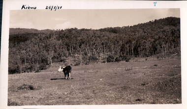
... was eventually acquired from the local land owners by the State... for grazing, and the land was eventually acquired from the local land ...This photograph was taken in August, 1938, some eight years prior to the establishment of Mt. Beauty a a township. The area was still being used for grazing, and the land was eventually acquired from the local land owners by the State Electricity Commission. The construction of the road, from Tawonga to the High Plains, was commenced in April, 1938 and this photograph was taken August, 1938. This allowed men and heavy equipment to be transported to the work sites for the construction of the Kiewa Hydro Electric Scheme. Prior to this access was by bridle trail, either on horse back or on foot. By 1946 housing construction had commenced for the new town of Mt. Beauty and by 1948 street construction in the southern part of the town was completed as far as Hill Street.This photograph is important as it shows the upper Kiewa Valley as it was before the establishment of the town of Mt. Beauty. The land has been cleared of natural vegetation to allow grazing of cattle. Black and white photograph of grazing farmland with one animal standing in the paddock. The area could possibly be where the golf course now stands with the road to the high plains not yet commenced.Handwritten in the upper left hand corner 'Kiewa 25/8/38'. The number 7 has been stamped in the upper right hand corner. It is part of a set of 8 photographs. On the back are the words Velox repeated several times, indicating the type of photographic papergrazing, kiewa, mt. beauty, secv -
 Kiewa Valley Historical Society
Photograph Farm Land, Kiewa, 25/8/38, circa 1938
... was eventually acquired from the local land owners by the State... land owners by the State Electricity Commission ...This photograph was taken in august, 1938 some eight years prior to the establishment of Mt. Beauty as a township. The area was still being used for grazing cattle and the land was eventually acquired from the local land owners by the State Electricity Commission. The construction of the road, from Tawonga to the High Plains, was commenced in April of 1938. This allowed men and heavy equipment to be transported to the work sites for the construction of the Kiewa Hydro Electric Scheme. Prior to this access was by bridle trail, either on horse back or by foot. By 1946 housing construction had commenced for the new town of Mt. Beauty and by 1948 street construction in the southern part of the town was completed as far as Hill Street.This is an important photograph as it shows the upper Kiewa Valley and the site for Mt. Beauty as it was before the establishment of the town. The land has been cleared of natural vegetation and used for grazing cattle.Black and white photograph of farmland, cattle in the distance, hills in the backgroundHandwritten in the upper left hand corner, in black ink, 'Kiewa 25/8/38'. The number 8 has been stamped in the upper right hand side of the photograph. On the back have been stamped the words Velox, indicating the type of photographic paper.kiewa, mt. beauty, construction, grazing, secv -
 Bacchus Marsh & District Historical Society
Map, Plan of Land at Bacchus Marsh, the Property of James Young, 1868
... James Young was a prominent businessman, land owner...James Young was a prominent businessman, land owner ...James Young was a prominent businessman, land owner and public figure in the early colonial period of Bacchus Marsh. In February 1868 he offered for sale through the agent W. Anderson 38 blocks of land which ran from the Lerderderg RIver westwards beyond Gisborne Road in the vicinity of the present day Masons Land. The land for sale was described as, 'unsurpassed Agricultural Land, in the immediate vicinity of Bacchus Marsh, varying in size from 2 to 12 acres each'. The sale notice in the Bacchus Marsh Express of 1st February 1868 page 2, also noted that, ' Plans can be seen at Mr. Young's Border Mills Store, and at the Border Inn'. One of the largest and most important land sales in the early colonial period of Bacchus Marsh.A single page paper map showing 38 blocks of land for sale in 1868 in the vicinity of Masons Lane Bacchus Marsh. Scale 11 chains to 1 inch. The map is pasted into a bound volume containing 76 maps or plans in total. High resolution digital image stored on BMDHS computer network. land sales bacchus marsh, bacchus marsh victoria maps, james young 1816-1871, masons lane bacchus marsh land sales -
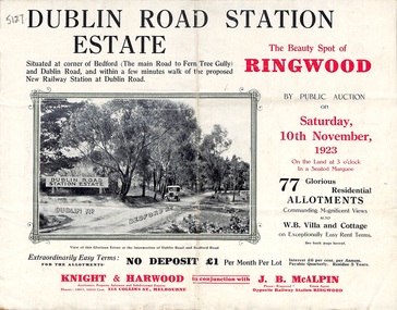 Ringwood and District Historical Society
Pamphlet, Land Sale Brochure, Dublin Road Station Estate - 1923
... of the station was £3700. Land owners in the locality should pay... of the station was £3700. Land owners in the locality should pay ..."Extracts from Recent Daily Newspaper - Ringwood Train Service - STATION WANTED AT RINGWOOD EAST. A deputation from the Ringwood East Railway League and Progress Association waited on the chairman of the Railway Commissioners yesterday afternoon and asked that a railway station be erected at Dublin-road, a mile and a quarter from Ringwood. The deputation urged that there were 81 passengers who, if the station were provided, would make daily use of it, and that as the Commissioners had purchased a site for a station at Dublin-road it was evident they had at one time considered it the most suitable site. The Chairman of Commissioners stated that the estimated cost of the station was £3700. Land owners in the locality should pay a proportion of the cost. Members of the deputation replied that there would be no difficulty in raising the money."Multi-fold brochure advertising public auction of residential allotments on Saturday, 10th November, 1923. Brochure includes subdivision features, local facilities and photographic images of the area and details of proposed new railway station at Dublin Road.Subdivision plan includes Dublin Road, Alexandra Road, Vonadawn Avenue, Green Street, Howard Avenue, Wood Street, and Bedford Road (Main Ferntree Gully Road). Auctioneer - Knight & Harwood, 315 Collins Street, Melbourne, Phones Central 10615, 10616. Agent - J.B. McAlpin, Opposite Railway Station, Ringwood, Phone Ringwood 7. -
 Warrnambool and District Historical Society Inc.
Map, Department of Lands and Survey (Lithographers), Caramut township, 1938
... but shows the original land owners of each town allotment... land owners of each town allotment and of the surrounding area ...This map of the township of Caramut was produced in 1938 but shows the original land owners of each town allotment and of the surrounding area. The size of all the allotments and the date of the original purchase are also shown. Caramut is a Victorian Western District town on Mustons Creek on the Hamilton Highway 48 kilometres from Warrnambool. This map was used by Rolf Crawley when he was the engineer for the Shire of Warrnambool from 1935 to 1968. The annotations on the map have probably been made by Rolf Crawley as they refer to the records and letter books of his father, John William Crawley, Junior (Shire of Warrnambool Engineer 1895 to 1935). Both Rolf Crawley and his father, John had private businesses as architects, surveyors and engineers and the map could have been used in connection with both their official Shire duties and their private businesses. The last owner of the map was the surveyor, Michael Hand who took over the business of Rolf Crawley in the late 1960s. This map is of great interest firstly because it has all the historical details of the land first purchased in the town of Caramut and area and secondly because it came from the office of Rolf Crawley, the engineer for the Shire of Warrnambool from 1935 to 1968. This is a buff-coloured paper map with a cloth backing. The map details are in black and white print. There are some handwritten red and black annotations on the map. “Town of Caramut Parish of Caramut County of Villiers’town of caramut, john william crawley junior, warrnambool, rolf crawley, warrnambool -
 Orbost & District Historical Society
plan, before 1948
... rate charged on the farmers and land owners in the Trust’s... rate charged on the farmers and land owners in the Trust’s ...Drainage infrastructure was developed and maintained in this region by the Snowy River Improvement Trust. The Trust was administered by a local committee and its activities funded by a local rate charged on the farmers and land owners in the Trust’s designated district. The level of the rate charged by the Trust was designed to be proportionate to the benefit derived from the works undertaken. Financial assistance was provided by the State Government from time to time for specific projects such as post flood repairs but not for new capital works. The Trust undertook new drainage and river management works including tree planting, rock beach construction and servicing of the drains and flood gates. The Trust also provided a personal flood warning service to the farmers in its district. The Trust ceased to operate in 1997 with the advent of the East Gippsland Catchment Management Authority. The infrastructure developed by the Trust continues to provide a service to the farmers in the region. (ref. 4 East Gippsland CMA Submission to Inquiry into Flood Mitigation Infrastructure in Victoria) This plan is significant as a historical document. The Snowy River Improvement Trust was vital to the Orbost district because of its ability to apply local knowledge and to engage the local farming community.A large plan of divisions of land for the purpose of levying the Snowy River Improvement District - Bete Bolong, Orbost, Waygara, Newmerella and Orbost East. The properties are coloured according to levy amount. The scale is 1" - 20 chains. snowy-river-improvement-trust -
![Map, Plan of Town Allotments Bacchus Marsh [1873]](/media/collectors/5e461d8021ea67224c82f2a1/items/677a8ee7ab7bb47995c5573f/item-media/677a8fdeab7bb47995c55b56/item-fit-380x285.jpg) Bacchus Marsh & District Historical Society
Bacchus Marsh & District Historical SocietyMap, Plan of Town Allotments Bacchus Marsh [1873]
... James Young was a prominent businessman, land owner...James Young was a prominent businessman, land owner ...James Young was a prominent businessman, land owner and public figure in the early colonial period of Bacchus Marsh. After his death in 1871 land remaining from his estate in Bacchus Marsh was sold at auction in 1873. The sale of his estate included the substantial stone residence in Bennett Street which later became known as 'Stone Villa'. The sale of his land in 1873 was conducted by local auctioneer James Crook. 29 allotments were advertised for sale, although the plan for the sale indicated 30 allotments. The sale notice in the Bacchus Marsh Express of 11 October 1873 noted that the allotments were " in the very centre and heart of the most populous and business portion of the township, at the same time being the only remaining portion of the business block available for purchase by public sale, which fact intending purchasers should not lose sight of, as the opportunity cannot occur again". The designation of a new street, 'Bennett Street', shown on the plan, is also indicated in the advertising, "In reference to the main street frontages, opposite the Border Flour Mills. The Auctioneer would also direct attention to the plan, showing the formation of a new thorough fare (Bennett street) leading from Young street into Gell street, thus opening up the township on the high, more healthy, and commanding position so much to be desired for private dwellings".An important cartographic document which indicates an early major subdivision of land in the inner urban area of the Bacchus Marsh township. This subdivision lead to the continuing residential and commercial development of the township of Bacchus Marsh in the later part of the 19th century. The location of two well known demolished public structures, the Free Gardeners Hall in Gell Street, and the Old Mechanics Institute Hall (aka the Buffs Hall), on the corner of Young and Bennett Streets, are also shown on this map.A single page paper map showing 30 blocks of land for sale around 1873 in the vicinity of Bennett Street and Lerderderg Street. Described in contemorary sources as a 'lithographed copy'. No scale is indicated. The map is pasted into a bound volume containing 76 maps or plans in total. High resolution digital image stored on BMDHS computer network. land sales bacchus marsh, bacchus marsh victoria maps, james young 1816-1871, bacchus marsh roads and streets, bennett street bacchus marsh -
Phillip Island and District Historical Society Inc.
Document
... Trader, Ship Owner, Over lander, Flour Miller and Politician..., Merchant Trader, Ship Owner, Over lander, Flour Miller ...Letters from Victorian Pioneers 51. John Hart. The career of John Hart after leaving England as a boy and at 22 becoming a Commander of a Bass Strait Sealing Schooner. After losing much of his personal wealth, he lived in South Australia to become Premier three times from 1865 - 71. His association with Phillip Island was Shipping, bark to London.Synopsis of the life of John Hart. Sea Captain, Merchant Trader, Ship Owner, Over lander, Flour Miller and Politician. Born in England 1809, died in Adelaide 28th January, 1873. This article on John Hart was followed by an account of his writings October 1834 on his bark collection enterprise in Westernport and Phillip Island.First commercial venture in Westernport. John Hart and Griffiths Sealer/Whaler "Elizabeth"local history, documents, letters, john hart, politician, merchant trader, black & white photograph, miss elms san remo -
 Wycheproof & District Historical Society Inc.
Bunguluke Map, Bunguluke District In 1923, 27.2.1923
... references land blocks and owners for that era.... holdings. The map references land blocks and owners for that era ...By 1881 Bunguluke was a small settlement as recorded, December 5, in the Charlton "Mercury". It reports that in that year Draper's Store, Hotel and Post Office and residence at Bunguluke North was totally destroyed by fire. For years now there has been little sign of community life with houses few and far between and acreages have gone into larger holdings. The map references land blocks and owners for that era.This important map shows the local land ownership and local features that existed in 1923. This is a photocopied black and white map of Bunguluke in the County of Kara Kara, Number L5149. Marked - Photo Lithographed by W.J. Butson 27.2.1923. The details include numbers of allotments, property owners, roads, rivers. The boundaries marked are the Parish of Jeruk, Parish of Wycheproof, Parish of Cooroopajerrup. Wycheproof township location is shown with the Scale of Chains. Bunguluke maps for other years are also in the collection.map, bunguluke, jeruk, wycheproof, cooroopajerrup -
Whitehorse Historical Society Inc.
Letter - Correspondence, Office of Lands and Survey, 1861
... , early owner of land that included what is now Matheson's orchard... is possibly Walter Thomas Fletcher, early owner of land that included ...Copy of letter written by W. Fletcher, Office of Lands and Survey, Melbourne, 2 Nov 1861.Copy of letter written by W. Fletcher, Office of Lands and Survey, Melbourne, 2 Nov 1861. Reporting that charcoal burners in the Parish of Nunawading are using wood for that purpose without a license and suggesting the policeman at Whitehorse by informed. Attached note suggests author is possibly Walter Thomas Fletcher, early owner of land that included what is now Matheson's orchard (1988).Copy of letter written by W. Fletcher, Office of Lands and Survey, Melbourne, 2 Nov 1861.charcoal burning, fletcher, w, forest hill, parish of nunawading -
 Melton City Libraries
Map, Streets of Melton, 1963
... early map. DODEMAIDE Place Early land owners.... DODEMAIDE Place Early land owners - Melton Football Team had 6 ...MELTON’S STREETS Heritage Week 2014 What’s in a Name? Alphabetical List Aboriginal place names, Early Family Names and landowners, Agricultural, Shop and Commercial premises, Places and Events Melton & District Historical Society Street Naming Project 1972 – c 1998 Suburb Name – KURUNJANG - Kirkton, 1972, Brookfield, West, 1988 Melton and Town Centre - A joint collaboration with the Shire of Melton and Subdivision Developers ARNOLD Court – Family house - Arnolds Creek ALKEMADE Drive Family – Lime kilns Coimadia ALEXANDRA Street 1902 – Corination of King Edward VII and Queen Alexandra AVIATOR Place Event, location of plane crash – Jimmy Melrose 1936 Adina ?Annibee - Anniba? Agricultural Avon court .. .. BAKERY Square - Location of Jongebloed shop, bakehouse and stables BALUK Place Aboriginal BARLEYCORN Place Agricultural BILLING Place Name of Jimmy Melrose Uncle Noel Pemberton Billing BLACKWOOD Drive - Alexander Blackwood 1860c Registrar BARRIES Road C. E. Barrie “Darlingsford” farmer 1911, chaff mill owner BROOKLYN Road Staughton family residence. 1875 – Dismantled c 193? CAHILL Drive Family - Glenville Dairy CAMERON Court Family Canopus Place ? CANALLAN Drive Early Surveyor CAMPBELL Court Aviation – Melrose passenger 6th July 1936 CARBERRY Drive Michael, early landowner family CAREW Court Edward and Michael. Royal Hotel. Vera (Carew) Forran Singer - Opera CASEY Court Family CASHIN Court Family CHEVIOT Court Agriculture, breed of sheep CHESNEY Road was re named ( Minns Road being duplicated c 1973) CHRISTINA Crescent Christina McPherson, daughter of James and Mary Mary McPherson. Died 1955 aged 85 years COLLYER Close a deleted street (parallel to Yuille) re-used CORRIEDALE Road Breed of sheep CORR Court Teacher at first school, landowner CROXTON Court Name of the Hornbuckle and Knox family home DALEY Court - William Daley and family 1865 Bootmaker High Street DARLINGSFORD Boulevard - Name of early homestead Thomas B Darling 1853 DJERRIWARRH Court - Parish County of Bourke - very early map. DODEMAIDE Place Early land owners - Melton Football Team had 6 brothers playing c 1924 DONALD Court McPherson family 6 generations in Melton in 1936 DOUGAL Court DUNCAN Court .. .. DUNVEGAN Circuit Home of the McPherson family, castle Isle of Skye Name of bluestone house Smith Street (now at Willows) EMIL Court Jongebloed family EXELL Avenue Farming family Melton Sth- Closer Settlement 1907 EXFORD Road Exe former name of the Werribee river FARMER Court Name of early postmistress FERRIS Road John Ferris Farmer HANNAH Close First name of Hannah Watts – midwife HAYBALE Place Agricultural HELDER Court Early surveyor J Helder Wedge map HEWSON Street Winston Hewson Shire Engineer – check title c 1960 HENRY Street Township map c 1860 HESTON Street Heston Phoenix – C.J. Melrose plane HILDEGARDE Court Jimmy Melrose’s mothers name HOMESTEAD Close HORNBUCKLE Cres Farmers. Three members of family - Shire Presidents HURLEY Street Farmers IAIN Court Descendent of James and Mary McPherson JAMES MELROSE Drive Name appears on 2013 Melton information map JANG Place KURUN – jang KIRKTON Drive Name of the McPherson family home Toolern Vale Road KIRWIN Street Michael early landowners (deleted for freeway construction) KILPATRICKS Road Deleted when Barries Road was extended across Station Rd KOROROIT Court Early map, Parish of Kororoit. Creek name KNOX Circuit Family – Hornbuckle “Croxton Park” KURRUNJANG Drive Aboriginal name for people of the red earth – Suburb name Lara Place ? LLOYD Court Garage owners High Street. Laura lived to 100 years D 1955 LUBY Court John Luby – Crown Grant Land Title LITTLE Court MANNING Avenue Richard, hotel owner 1891 MARGARET Drive McPherson family McDONALD Street Melton South family name McKENZIE Street Township c1860 MORROW Street Early name MOWBRAY Crescent Name of English Melton, popularly believed origin of Melton MYERS Court Early setters c 1866 Crown Grant Land Title NIMMO Street Early name NIXON Street Name submitted by Mary nee Nixon Collins c1985 OLDERSHAW Road Early builder PALMERSTON Street Early township map c 1860 PEART Court Early name PENNYROYAL Avenue Plant growing by the creek. Early name used for the Toolern Toolam Creek PINKERTON Street Family name and early street map PINNACLE Crescent Agricultural - type of wheat PHOENIX Circuit C.J. Melrose Phoenix Heston Plane 2013 map PRATT Family PRIOR Court PYKE Place Brothers – early settlement 1838 RADFORD Court Land owners and business operators. Former Royal Hotel Grocer High Street demolished 1970 RAGLAN Court Hotel 19th century Lord Raglan RALEIGHS Road Oliver Reierson family (Norweigen) Shopkeeper – Dressmakers RIDDELL Drive (misspelt Riddle) Resident and land owner RODERICK Road McPherson family – a re occurring name ROLLAND Court Jones family ROSS Court Daniel. Landowner. Agnes Ross music teacher RUSSELL Court Robert. Early land surveyor of Melton 1853 RYAN Court Family early landowner. Member of the 1862 Road Board SHEBLER Place Augustus early Melton resident – Golden Fleece Hotel SHEEPFOLD Court Farming SHERWIN Court Sherwin Street earliest Township map– became Golf course SMITH Street Early township map. STRATHULLOH Circuit Strathtulloh Homestead. STAUGHTON Street Family – LARGE land owners Strachan ? SWANEY Court Marie Swaney earlier resident of Strathtulloh. SUTHERLAND Family name TOOLERN Street TOOLAM – TOOLERN Creek TULLIDGE St Road marked on 1861 map UNITT Street Early Township c 1860 WALLACE Square Cr Jack Wallace 5 terms as President 46 years unopposed WATTS Court Hannah Watts – midwife, cottage hospital WALSINGHAM Name of house of Minns family. From Walsingham Norfolk England WESTLEY Place Name of Jimmy Melrose Percival Gull Plane WESTLAKE Drive Early resident WHICKHAM Street Family Name Melton South WILSON Road Albert, Melton South YUILLE Street William Cross, early landowner, Rockbank run Zoomed in section of Melton Streets including Church and High Streetlandscapes of significance -
Port Melbourne Historical & Preservation Society
Plan - Subdivision of area bounded by Nott Street, Rouse Street, Beach Street, Port Melbourne, Block Number 2067, 1884
... , Beach Street, showing subdivision of land with relevant property..., Beach Street, showing subdivision of land with relevant property ...Copy of plan of area bordered by Nott Street, Rouse Street, Beach Street, showing subdivision of land with relevant property owners (HB DONALDSON, J NOLAN, J Hill and Sons, GW ROBINS, Carl ECKBURG, JM SMITHSON, J WALLACE) Block number 1, Port Melbourne 1884, Block number 20.67. Water Mark on Paper "J Whatman 1883"built environment - domestic, j whatman, henry beveridge donaldson, j nolan, j hill and sons, g w robins, carl eckburg, j m smithson, j wallace -
 Glen Eira Historical Society
Album - Album page, Glen Huntly Road, Circa 1972
... for their association with the early Elsternwick land owner, Hugh Moore, whose... for their association with the early Elsternwick land owner, Hugh Moore, whose ...This photograph is part of the Caulfield Historical Album 1972. This album was created in approximately 1972 as part of a project by the Caulfield Historical Society to assist in identifying buildings worthy of preservation. The album is related to a Survey the Caulfield Historical Society developed in collaboration with the National Trust of Australia (Victoria) and Caulfield City Council to identify historic buildings within the City of Caulfield that warranted the protection of a National Trust Classification. Principal photographer thought to be Trevor Hart, member of Caulfield Historical Society. Most photographs were taken between 1966-1972 with a small number of photographs being older and from unknown sources. All photographs are black and white except where stated, with 386 photographs over 198 pages. From: Glen Eira Heritage Management Plan (1996) by Andrew Ward and Associates Moore's Buildings", were built in 1891 and comprising 5 shops. In 1888, Hugh Moore, a gentleman, subdivided his land in Glen Huntly Road, north side between Selwyn Street and St Georges Road into 27 lots, with a right of way separating them from his property "Glenmoore". The subdivision was known as the "Glenmoore Estate". Purchases of land included local builders Corkill, French and Pugh. Moore retained five lots and W.W. Jamieson bought lots 11 to 14. "Moore' s Buildings are locally important for their association with the early Elsternwick land owner, Hugh Moore, whose home, "Glenmoore", at 1 St.Georges Road (qv) survives. They recall Elsternwick's role in the Land Boom and survive as a most prominent row in the Glen Huntly Road shops, enhanced by the survival of the unpainted stuccoed surfaces to nos. 307-311. 287-289 Glen Huntly Road: contributory to HO72, Elsternwick Estate and Environs, City of Glen Eira.Page 63 of Photograph Album with one landscape photograph of retail shops (Moore's Buildings).Hand written: 287-289 Glen Huntly Road [under photo] / 63 [bottom left] trevor hart, shop, grocer, stuccoed, terrace, victorian terrace, protruding parapet, ornate render, hugh moore, 1890's, moore's buildings, glenmoore, glenmoore estate, shopping centres, milk bars, cars, victorian style, glen huntly road, glenhuntly road, elsternwick -
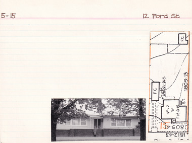 The Beechworth Burke Museum Research Collection
Card (Series) - Index Card, George Tibbits, 12 Ford Street, Beechworth, 1976
... , Richard (no tenant listed), owner, land £5 Architectural Index... & 6 - 1906 - Warren, Richard (no tenant listed), owner, land ...George Tibbits, University of Melbourne. Faculty of Architecture, Building and Town & Regional PlanningIndex system that support the research for Beechworth : historical reconstruction / [by] George Tibbits ... [et al]Arranged by street names of BeechworthEach index card includes: street name and number of property, image of property, allotment and section number, property owners and dates of ownership, description of the property according to rate records, property floor plan with dimensions.beechworth, george tibbitsbeechworth, george tibbits -
Ringwood and District Historical Society
Name List, A suggested list of names suitable for streets in Ringwood, and showing origin of name - compiled 1970, c.1970
... of Surveyors etc. Original Land Owners; Isaacs,S. G. Bought first... Land Owners; Isaacs,S. G. Bought first land in Ringwood - March ...A suggested list of names suitable for streets in Ringwood, and showing origin of name. Two pages foolscap, 100 names approx. ; Hull: Surveyed Gippsland Road now Maroondah Highway, 1855 (Also name of roar in Croydon); Darke, Wm Wedge, Surveyed all land between Yarra and Western Port, including Ringwood - 1843; Wedge, Chas. Nephew of John Helder Wedge, Batman's surveyor, 1834. Active in Ringwood East Progress Association over 40 years ago.; "Barker's Track" - forerunner of Gippsland Road, Maroondah Highway.; Bickford, N Superintendent of Hodgkinson's Field Party of Surveyors etc. Original Land Owners; Isaacs,S. G. Bought first land in Ringwood - March 1858 - Lot 3; Moss, M.Lot 1 - April 1858; Davis, J. Lot 6 - April 1858; Riley, P. Lot 11 - April 1858; Marks, M.Lot 15 - November 1858; Wieland, C.F. Lot 14b - July 1872; Richter, K.H. Lot 14a - April 1869; Molloy, J. Lot 21 - December 1877; Watson, B. Lot 22a - April 1869; Stutt, W. Lot 27 - June 1884; Blood, R & W.Lot 42-3 - March 1872; Cox, J. Lot 41 - March 1870; Moncrieff, T.Lot 40a - September 1876; Pett, J. Lot 40b - January 1878; Feltham, F. Lot 28a - September 1881; Downing, J.J.Lot 32b - October 1881; Burge, W. Lot 39 - April 1875; Axford, W. Lot 32a - December 1877; Ball, E.A.Lot 37 - March 1869; Parker, G. Lot 28 - June 1882; Gangell, W.Lot 24a - January 1883; Hodgson, A.D. Lot 25a - May 1875; Muldowney, P. Lot 30d - June, 1877; Hosie, J.S. Lot 34, 30b - June 1878; Rourke, H.Lot 36 - July 1869; Duggan, T.Lot 35 - May 1870; Pach, W. Lot 30e - May 1884; Morris, J. Lot 25b - June 1882; Kleinert, A. Lot 29c - August 1886 +Additional Keywords: Hull / Darke, Wm Wedge / Wedge, Chas / Wedge, John Helder / Bickford, N -
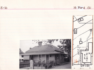 The Beechworth Burke Museum Research Collection
Card (Series) - Index Card, George Tibbits, 14 Ford Street, Beechworth, 1976
... , Owner, Land 33 x 165, prem 23 x 32 W.B. sh rf - £10 5-16 - 1889..., William - Warder, Owner, Land 33 x 165, prem 23 x 32 W.B. sh rf ...George Tibbits, University of Melbourne. Faculty of Architecture, Building and Town & Regional PlanningIndex system that support the research for Beechworth : historical reconstruction / [by] George Tibbits ... [et al]Arranged by street names of BeechworthEach index card includes: street name and number of property, image of property, allotment and section number, property owners and dates of ownership, description of the property according to rate records, property floor plan with dimensions.beechworth, george tibbitsbeechworth, george tibbits -
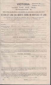 Bendigo Historical Society Inc.
Document - KELLY AND ALLSOP COLLECTION: VICTORIA LAND TAX ACT 1910 - FORM, 31/12/1910 to 01/03/1911
... of Schedule B of Land Tax Act of Victoria 1910. 'Return of Land.... Instructions to taxpayers 'Every owner of land must furnish a return ...Document. KELLY & ALLSOP COLLECTION. Three copies of Schedule B of Land Tax Act of Victoria 1910. 'Return of Land and Monies Owing on Mortgage of Land.' Each form partly filled out by Arthur Allsop in pencil, ie 'Particulars of Land' section. He owns two houses in Wills St and a vacant block of land at Pyke/Brodie Streets. Instructions to taxpayers 'Every owner of land must furnish a return before 1st March 1911 of all lands owned on 31 Dec 1910.'Taxation Office of Victoriabusiness, stockbroker, kelly & allsop, kelly & allsop collection, victoria land tax act 1910, schedule b -
Whitehorse Historical Society Inc.
Document, William Witt, n.d
... President of Shire of Nunawading, owner of land on cnr... of Nunawading, owner of land on cnr of Heatherdale and Canterbury Roads ...Collection of documents on William Witt J.P., first President of Shire of Nunawading, owner of land on cnr of Heatherdale and Canterbury Roads. Contents: 1. Summary of life. 2. Mail coach ticket. 3. List of dates and places of birth of William Witt, his wife and their children. 4. Obituary #1 5. Obituary #2 (South Yarra Gazette). 6. Autobiography typewritten by Mr Matthews. 7. Extract from Jubilee History of Victoria. 8. Newspaper article. 9. Sketch by Norma Jamieson.witt, william, shire of nunawading -
Glen Eira Historical Society
Letter - HUNT, WILLIAM HOGARTH
... owners, land sales and identities, Murray Ross, Mr Burr of Burr’s... of residents, shop owners, land sales and identities, Murray Ross, Mr ...Two sets of this man's handwritten memories: 1/Five pages of handwritten personal memories, written by William Hogarth Hunt 13/07/1977. He outlines his family, their travels and settlement in 1908 at Glenhuntly: a detailed account of residents, shop owners, land sales and identities, Murray Ross, Mr Burr of Burr’s Gun Oil and Mr Zarman. Also details Glenhuntly Methodist Church, football, athletics, Glenhuntly Aerodrome and an extensive list of local residents and their stories. 2/Two pages of handwritten personal memories, written by William Hogarth Hunt 02/09/1977. A detailed account of residents, shop owners, identities, athletes, local policemen and their stories in the Glen Huntly area.personal memories, hunt william hogarth, glenhuntly, grange road, trams, plumber, stone mary ann, neerim road, wanalta road, schurme mrs, private hospital, hospitals, watson grove, hunt jessie, hunt alfred, hunt charles, smith mr, fisher mr, smith mrs, jockeys, dore george, ‘willis’, builders, house names, mernda, roseberry grove, el nido, neerim road, glenhuntly post office, mrs fielder’s sweetshop, mrs beer’s sweet shop, paddocks, confectionery, fielder fred, maroona road, murrumbeena, grocers, callister dave, carnegie state school, hay and corn store, james street, woodyard, hillards chemist, hughes body works, chemists, davidson’s, glenhuntly printing, hay and corn stores, railway gates, anz bank, fox mr, martin jack, fox mrs, clothing stores, steam rollers, radio and tv shop, beasley j, delicatessen/ham and beef shop, butchers, schurme’s private hospital, gellatley george, tailors, commonwealth banks, watson grove, banks, preston peter, e.j. & h. amos, hardware stores, estate agents, glenhuntly picture theatre, whittle mr, theatres, newsagency, cooper and cooke, station street, f.j. long and co, jennings a.v, timber yards, builders, ‘the estate’, hillcrest estate, grange road, marara road, rosedale avenue, hobart jack, mackie road, confectionery stores, ross murray, glenhuntly athletic club, godfrey evelyn, athletics clubs, railways, glenhuntly junior football club, elsternwick, princess park, carnegie oval, booran road, koornang park, ormond oval – ee. gunn reserve, glenhuntly oval, oakleigh road, victorian amateur turf club, koornang road, glenhuntly aerodrome, neville street, glenhuntly state school, rosslyn street, geary mr, lauriston tennis courts, bakers, carnegie r.s.l., east bentleigh, bowling clubs, tucker road, tennis clubs, centre road, murrumbeena road, larman mr, hollway street, nurseries, parker street, lyle marshall, burr mr, solicitors, builders, bones nursery, ‘burr’s gunoil’, glenhuntly methodist church, carnegie, smith alf, ezard family, clemens family, noy family, noy clarrie, dickie family, storey family, storey george, davis family, joss house, chinese community, wattle avenue, grange road, glenhuntly amateur football club, football clubs, glenhuntly athletic club, athletic clubs, glen huntly junior football club, carnegie oval, koornang park, glenhuntly oval, victorian amateur turf club, glenhuntly aerodome, glenhuntly state school, geary mr., bakers, east bentleigh, tucker road, centre road, larman mr, nurseries, lyle marshall, solicitors, bones nursery, carnegie, "the estate", royal avenue, mckay avenue, dumsday bertha miss, love family, gilmour family, waratah ave, sinclair mr, tuckpointers, bricks, donegan mr, plumbers, frazer mr, frazer and jenkinson printers, frazer arthur, ezard manufacturing, jewellers, private hospital, maroona road, o'carroll mr, beattie mr, horse trainer, morton tom, lord harry, estate agents, ormond, councillors, taylor mr, builders, gibson family, westley alf, o'carroll j (jack) d, glenhuntly athletics club, athletes, jack page's bakery and cake shop, nay clarrie, hunt william h., hunt alf, page jack, armstrong jack, manchester grove, morgan advertising, cusdin sid, farrier, glenhuntly cricket club, caulfield racecourse, neerim road, hoffman's plumbing, emma street, st. agnes school, st. agnes church hall, jenkin 'boss' mr, teachers, hawthorn miss, quinn miss, chitty charlie, chitty's timber, crystal palace picture theatre, theatres, marsh bill, hardware shops, watson arthur w, j.s. kidd and company, marshes hardware, kidd's hardware, bruce ivy, 'belgrave', house names, belgrave road, dandenong road, hunter 'pud', police officers, hunt jess, kangaroo road, murrumbeena, glen huntly -
 Eltham District Historical Society Inc
Film - Video (VHS), Dynavision Video Production, 1994 Eltham Festival, 11 Nov 1994
... of the Wurrundjeri, traditional land owners of the area.... of the Wurrundjeri, traditional land owners of the area. 1st eltham brownies ...20th Eltham Community Festival and last under the auspices of the Shire of Eltham. The Grand Parade focussing on the theme "Echoes of Eltham - Celebrating the visions of Eltrham from the past and into the future" was headed by Jock Read on his horse Lofty who had been filmed in an Anzac Day Parade on an earlier horse which had featured in the television show Matlock. The parade travelled north along Main Street to just past the Post Office then back south to Panther Place. Parade participants included 1st Eltham Brownies, 1st Eltham Venturers, 2nd Eltham Sea Scouts, 2nd Eltham Venturers, 3rd Eltham Brownies, Australian Democrats, Briar Hill Primary School, Circus Chaos, Country Fire Authority, Diamond Valley People for Disarmament, Diamond Valley Railway, Eltham Community Health Centre, Eltham District Horse and Pony Club, Eltham East Primary School, Eltham Fire Brigade, Eltham Junior Football Club (Panthers), Eltham Little Theatre, Eltham North Primary School, Eltham Playhouse Co-op, Eltham Pre-school, Eltham Roller Skating Club, Eltham South Pre-School Centre, Eltham Steam and Stationary Engine Society, Greenhills Neighbourhood House, Heidelberg Municipal Band, Hurstbridge Learning Co-op, Jocklebeary Farm, Kangaroo Ground Primary School, Learning Co-op Primary School, Lower Plenty Primary School, Main Road, Montmorency Gardening Club, Montmorency South Primary School, North Warrandyte Fire Brigade, Plenty Valley 88.6 FM, Research Pre-school, Research Primary School, Ron Sampson, Salvation Army Band (Briar Hill), Sherbourne Primary School, Shire of Eltham, State Emergency Service (Eltham) and Woodridge Pre-school. The parade commentary was provided by Plenty Valley FM 88.6 with guest commentator, Shire President Cr. John Graves. Following the parade is video footage from a helicopter of Alistair Knox Park, displays along Main Road and activities in Alistair Knox Park and the Rugby oval along with stationary engines, helicopter joyrides, Eltham People's Choir, music entertainment. Scenes also from the Diamond Valley Railway at Eltham Lower Park and finishing with the fireworks display. At the end of the video is a promotional video for Dynavision Video Production, a local video production company that produced the video and Diamond Photos (Kodak Express). One of the highlights of the festival was a tree planting ceremony in Alistair Knox Park to celebrate 123 years of the Shire of Eltham led by Shire President Cr. John Graves and representatives of the Wurrundjeri, traditional land owners of the area.VHS Video cassette (poor quality) Converted to MP4 file format 45:01, 535MB DVD copy of VHS cassette (better quality)1st eltham brownies, 1st eltham venturers, 2nd eltham sea scouts, 2nd eltham venturers, 3rd eltham brownies, 1994, aerial photographs, alistair knox park, arthur street, australian democrats, briar hill primary school, circus chaos, country fire authority, diamond valley people for disarmament, diamond valley railway, eltham community health centre, eltham district horse and pony club, eltham east primary school, eltham festival, eltham fire brigade, eltham junior football club (panthers), eltham little theatre, eltham lower park, eltham north primary school, eltham people's choir, eltham playhouse co-op, eltham pre-school, eltham roller skating club, eltham south pre-school centre, eltham steam and stationary engine society, grand parade, greenhills neighbourhood house, heidelberg municipal band, hurstbridge learning co-op, jock read, jocklebeary farm, john graves, kangaroo ground primary school, learning co-op primary school, lofty (horse), lower plenty primary school, main road, matlock police (tv show), montmorency gardening club, montmorency south primary school, nicholaus lauder estate, north warrandyte fire brigade, plenty valley 88.6 fm, research pre-school, research primary school, ron sampson, salvation army band (briar hill), sherbourne primary school, shire of eltham, state emergency service (eltham), video recording, woodridge pre-school -
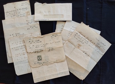 Mont De Lancey
Document - Land Receipts, M. H. Proctor, H. Proctor & W Hunter, 1946 - 1951
... , from W. Hunter (owner of the land). They are dated Feb 28th..., from W. Hunter (owner of the land). They are dated Feb 28th ...These are handwritten land receipt documents between Maxwell Proctor and W. Hunter (owner) 1946 - 1951 and between M.H. Proctor and H. Proctor 1947, 1948 and 1949.Two sets of handwritten land receipts in a used envelope with blue type at the bottom: Chamber of Manufactures Insurance Ltd. The first set of three receipts are written in copperplate handwriting for Mr. M. H. Proctor and are for the purchase of land, from W. Hunter (owner of the land). They are dated Feb 28th 1946, 17th April 1951 and an indecipherable date o the last one. The second set of six handwritten receipts are from M. H. Proctor to H. Proctor for land purchased: May 27th 1947, Dec 7th 1947, June 22nd 1948, Dec 14th 1948, May 30th 1949 and Dec.6th 1949. All letters are handwritten with a small green or yellow 3d. official Stamp Of Victoria glued to them. They are all signed by W Hunter or H. J. Proctor.legal documents, documents, land sales, contracts -
 Bacchus Marsh & District Historical Society
Map, Bacchus Marsh Township and Nearby Districts Maps Volume
... , (indicating property owners and land boundaries), land plans and real... property owners and land boundaries), land plans and real estate ...This volume of maps is believed to have been compiled by staff at the Shire of Bacchus Marsh and was presumably used to inform and assist Shire staff and Councillors in the carriage of their duties.This collection of maps are significant due to their rarity as many of them are unique maps made for local purposes in the Bacchus Marsh region. They are also of strong research value containing a wide variety of information including landholders, land sales, infrastructure, such as roads, bridges, public, commercial and private buildings, houses, land use, and geographic features over multiple decades from the late nineteen century into the middle part of the twentieth century.One bound volume of maps comprising cadastral maps, (indicating property owners and land boundaries), land plans and real estate auction plans and advertising material, and other maps indicating major infrastructure like proposed roads and irrigation areas. Most of the maps and plans are of Bacchus Marsh and nearby areas but some maps are of nearby towns such as Melton, Ballan and Blackwood. The volume comprises 52 pages. Most pages have a single map or plan pasted onto it but some contain 2 or 3 different maps. There are 81 maps in total. Map 1 Liquidators Sale 1896. Map 2. Woodside Estate Sale 1913. maps, maps bacchus marsh, maps bacchus marsh region -
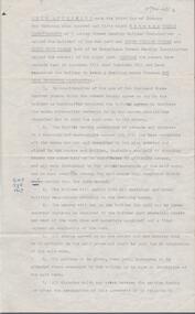
 Bendigo Historical Society Inc.
Document - MCCOLL, RANKIN AND STANISTREET COLLECTION: SOUTH FREDERICK THE GREAT CO NL, 1934
... , Parish of Yarraberb. Includes land for school, owners names... Charlton, Parish of Yarraberb. Includes land for school, owners ...McColl Rankin & Stanistreet, South Frederick the Great Co NL. a/ Plan of Residence Areas on No. 10287, by J O Charlton, Parish of Yarraberb. Includes land for school, owners names of blocks, crown land. Signed: Garnet G Birch. Dated 27/4/1935, licensed surveyor. b/ Letter from Department of Mines to McColl Rankin & Stanistreet in reference to letter regarding lease No. 10287. On back of letter are notes relating to blocks of land on lease No.10287. c/ Plan Of Area For On Lease No. 10287 Ben. By John O Charlton. Mining District of Bendigo, Parish of Yarraberb, Lease No. 10287 Ben. By John O Charlton. Mining District of Bendigo. Date 21/6/1934. Signed Garnet G Birch. Blocks include name of purchaser. d/ Plan Of Area For On Lease No. 10287 Ben. By John O Charlton. Mining District of Bendigo, Parish of Yarraberb, County of Bendigo. Dated 21/6/1934. e/ envelope inscribed South Fredrick the Great. 51.organization, business, gold mine, plan of area for on lease no. 10287 ben. by john o charlton. mining district of bendigo, parish of yarraberb, county of bendigo j o charlton garnet g birch department of mines lease no. 10287 ben. by john o charlton mining district of bendigo 1934 -
 Bendigo Historical Society Inc.
Document - H. A. & S. R. WILKINSON COLLECTION: AGREEMENT TO BUILD HOUSE
... , Bendigo (owners) whereas the owners have land in Specimen Hill... the owners have land in Specimen Hill Road and have requested he ...Agreement made the 3rd of January 1958 between Thomas James Roberts of 1 Ashley Street, Bendigo builder) and Peter William Tieman and Edith Ruby Tieman both of 60 Hodgkinson Street, Bendigo (owners) whereas the owners have land in Specimen Hill Road and have requested he builder to erect a dwelling house thereon. There 8 clauses on the agreement. There is also a sheet detailing the specifications for the build. Price: 2,300 pounds. Also, a paper signed by T. J. Roberts on the 3rd of January 1958 that on completion of contract for new building on block, lot 28, Specimen hill Road, Golden Square for P. W. & E. R. Tieman agreeing to pay H. A. & S. R. Wilkinson the sum of 82 pounds 10 shillings for commission due on such contract.h.a. & s.r. wilkinson, real estate, buildings -
 Ringwood and District Historical Society
Letter, Letter written by H.C.Howship to Ringwood Mail Ringwood 1963
... residents and land owners for the erection of the Ringwood East... raised the sum of about 1,600 from residents and land owners ...To the Editor of the Ringwood Mail Dear Sir, would you please publish in your widely read paper the following letter for the information of the residents of the City of Ringwood- Re the passing of my brother Mr. J.P. Howship, who was an ANZAC one of the pioneer family of Howship of Ringwood which name is connected with the early history of Ringwood or more particularly Ringwood East as the late J.P. Howship and myself purchased the Nursery of Mr. John Hill around the year 1912 and after a couple of years my late brother Bert was taken into partnership and we bought the adjoining nursery of Mr. Will Hill and traded under name Howship Bros. Rosedale Nursery and the name of one street in the old property Howship Avenue is named after the old firm as well as Rosedale Crescent. The move for the establishment of the Ringwood East station started with myself and in a meeting up with a Mr .T. Birkitt who I felt was the man I needed as he was a sub Estate Agent .A meeting was called and held in our packing shed at the end of Federal Road which at that time ended at Mr. Charlie Burdens property and abbuted (sic) on our property. This meeting was attended by about sixty residents and the late Mr. C. Wedge was elected as the first President of the Ringwood East Railway League and Progress Assoc. with Mr. T. Birkitt as Secretary and myself as assist. Secretary. This League raised the sum of about 1,600 from residents and land owners for the erection of the Ringwood East Railway Station & after the station was erected and paid for the League part was canceled and the Progress Assoc. carried on. The present Ringwood East Cricket Club was formed at meeting and the Prog .......and my three brothers Bert, Mervyn and played cricket in the Ringwood district for many years and most of us were members of the Ringwood at first and then the Ringwood East Football clubs and followed the teams for years a few names of the old players came to mind in E. Thomas , C. Weil, T. Homewood, the Pratt family and others. I might mention for the benefit of the City of Ringwood residents my eldest brother Laurie late of New Street and now living at Blairgowrie was with what was then known as Coopers Mills and designed and helped to build some of the first buildings in that property now known as Ringwood Timber & Trading Co .Also that myself and others namely the Reidy Brothers, Mr. Taylor, & L .Cleary & voluntary labour formed the tennis courts at East Ringwood with the help of our young Ladies of the time, those courts I'm pleased to say are well established and two more are added and provide good activities for the young people of the district. Also with the aid of C .Thomas, Norm Blood and others we formed the Methodist courts. From the Ringwood East Progress Association came the move to have a Health Centre for Ringwood. This was established by a good deal of enthusiastic work by some mothers after spending nearly fifty years in Ringwood watching it grow from town surrounded by orchards to a City and I must congratulate the Civic Fathers and their staff in the growth of Ringwood and the fine roads, Parks, Elderly Citizens Club and have all done a good job but why oh why have you neglected mines Road Ringwood east. Why has this road not been made the drainage there is something to be seen to be believed in such a city .The only solution is making and curbing this road & I would ask those responsible why the curbing was put down Dublin Road where there are no residents this curbing could well have solved the problem in Mines Road if used there. I recently spent a weekend with my Daughter, Mrs. Munro at the corner of Maroondah highway and Mines Road and was disgusted at the condition of Mines Road and drainage and had to air my views and suggest a trip to Mines Road by the Civic Fathers led by the Health Inspector I am yours sincerely H.C. Howship Sheila Street, Rye. (copied here verbatim)3 pages of hand written letter detailing the early history of the East Ringwood Railway and Progress Association, football, cricket and tennis clubs.. Written as a draft in 1963.