Showing 99 items
matching maps bacchus marsh
-
 Melton City Libraries
Newspaper, Melton Fire Station, 1974, 1975
In 1975 the Melton Fire Station opened in McKenzie Street. In the 1950s with the introduction two-way HF and later VHF very high frequency radio sets. Melton Rural Fire Brigade was part of the Bacchus Marsh Group. Radio sets where located in the Melton Fire Truck, and in the house of the Barrie family at Ferris Road. This was an ideal location to observe a 360 degree view in all directions when smoke appeared on the horizon. An antenna was erected beside the house. The set OX 7 was located in the kitchen and monitored 24 hours by the family. When an electrical fire occurred at the junction of the electricity to the house there was time to radio the fire station and summons the men working in the paddocks, thus saving the house from possible destruction. With the introduction of UHF – ultra high frequency Vinten Radios the signal was clearer and static and interference lessened and radio traffic became easier to read, and reduced noise levels in the household. In 1974 when the family moved to First Avenue, another antenna and a small building were erected adjacent to the residence and used to house the equipment, maps. Radio traffic consisted of regular schedule times and communication with adjoining groups of brigades such as Bacchus Marsh, Mt Macedon and Little River Groups. Many of the brigade and group base radios were situated in private residences and operated primarily by fire fighters wives who held the position of Communications Officer, either registered as a brigade member or informally.Regional News Gazette article about the construction of a new fire station in Melton and an Express article with brigade members at the opening of the station.emergency services -
 Bacchus Marsh & District Historical Society
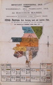
Map, Important Subdivisional Sale at Bacchus Marsh, Wednesday 28 February, 1912, 1912
In the later 19th century and early 20th centuries Thomas Cain was a major farmer in the Bacchus Marsh district and a significant participant in community life and affairs. The sale of some of his most significant properties towards the end of his life generated wide interest in Bacchus Marsh and beyond.Paper. 33cm x 21cmnon-fictionIn the later 19th century and early 20th centuries Thomas Cain was a major farmer in the Bacchus Marsh district and a significant participant in community life and affairs. The sale of some of his most significant properties towards the end of his life generated wide interest in Bacchus Marsh and beyond.land sales, thomas cain, landholders -
 Bacchus Marsh & District Historical Society
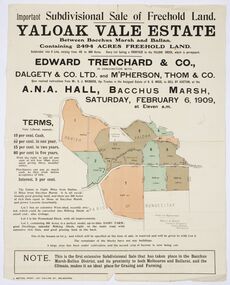
Map, Edward Trenchard & Co, Important Subdivisional Sale of Freehold Land Yaloak Vale Estate
A land sales map and advertisementLand sales advertising poster with map indicating specific lots of land for sale.A land sales map and advertisementimportant subdivisional sale of freehold land yaloak vale estate, land sales -
 Bacchus Marsh & District Historical Society
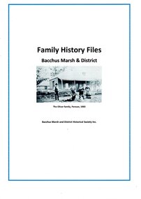
Document, Family History Files, Bacchus Marsh & District
Family History files relating to families and individuals from the township of Bacchus Marsh and its surrounding district. Files may contain family trees, replies to research inquiries, obituaries, biographical material, photocopies of published and unpublished material from books, newspapers, magazines, pamphlets, maps, archival sources and personal papers. Material may also include copies data from births, marriages, deaths, funeral, cemeteries and other genealogical registers and indexes. of Other material includes printouts of website pages, and photocopies or printouts of images. Arranged in A-Z sequence by family surname.Paper documents in ring and lever arch foldersFamily History files relating to families and individuals from the township of Bacchus Marsh and its surrounding district. Files may contain family trees, replies to research inquiries, obituaries, biographical material, photocopies of published and unpublished material from books, newspapers, magazines, pamphlets, maps, archival sources and personal papers. Material may also include copies data from births, marriages, deaths, funeral, cemeteries and other genealogical registers and indexes. of Other material includes printouts of website pages, and photocopies or printouts of images. Arranged in A-Z sequence by family surname.obituaries, funeral notices, death notices, births, marriages, cemetery records -
 Bacchus Marsh & District Historical Society
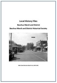
Local History Files Bacchus Marsh and District, 1969- to present
Local history subject files relating to the township of Bacchus Marsh and its surrounding district. Files may contain replies to research inquiries, photocopies of published and unpublished material from books, newspapers, magazines, pamphlets, maps, archival sources and personal papers.. Other material includes printouts of website pages, and photocopies or printouts of images. Material compiled by members of Bacchus Marsh and District Historical Society.Paper files in ring folders and lever arch folders. Arranged in A-Z sequence of topics.non-fictionLocal history subject files relating to the township of Bacchus Marsh and its surrounding district. Files may contain replies to research inquiries, photocopies of published and unpublished material from books, newspapers, magazines, pamphlets, maps, archival sources and personal papers.. Other material includes printouts of website pages, and photocopies or printouts of images. Material compiled by members of Bacchus Marsh and District Historical Society.local history, bacchus marsh -
 Bacchus Marsh & District Historical Society
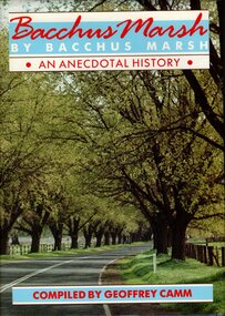
Book, Bacchus Marsh by Bacchus Marsh: an anecdotal history, 1986
Bacchus Marsh by Bacchus Marsh is an anecdotal history of the town and district of Bacchus Marsh. It is a collection of memories of 49 residents recorded in oral history interviews and then adapted into a written record. Most of the interviewees had lived in Bacchus Marsh for many decades and are from a variety of occupations and backgrounds. The oldest interviewee was born in 1890 and the youngest was born in 1938. The interviews were conducted by Geoffrey Camm who then transcribed them and edited them for this publication. A black and white photographic portrait of each interviewee accompanies each chapter. The book includes maps and an index of individual and family names. Publication citation: Camm, Geoffrey, compiler, Bacchus Marsh by Bacchus Marsh: An anecdotal history, Bacchus Marsh, Vic. : Shire of Bacchus Marsh in conjunction with ; Melbourne: Hargreen Publishing, 1986. 392 pages.non-fictionBacchus Marsh by Bacchus Marsh is an anecdotal history of the town and district of Bacchus Marsh. It is a collection of memories of 49 residents recorded in oral history interviews and then adapted into a written record. Most of the interviewees had lived in Bacchus Marsh for many decades and are from a variety of occupations and backgrounds. The oldest interviewee was born in 1890 and the youngest was born in 1938. The interviews were conducted by Geoffrey Camm who then transcribed them and edited them for this publication. A black and white photographic portrait of each interviewee accompanies each chapter. The book includes maps and an index of individual and family names. Publication citation: Camm, Geoffrey, compiler, Bacchus Marsh by Bacchus Marsh: An anecdotal history, Bacchus Marsh, Vic. : Shire of Bacchus Marsh in conjunction with ; Melbourne: Hargreen Publishing, 1986. 392 pages.bacchus marsh, bacchus marsh history, biographies, anecdotes -
 Bacchus Marsh & District Historical Society
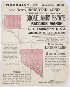
Map - Land Sales Plan, Broadlands Estate, Bacchus Marsh, 1916
... Library Main Street Bacchus Marsh This land sales map was produced ...This land sales map was produced by real estate agents for an auction of part of a property near Bacchus Marsh known as the Broadlands Estate. 132 acres of irrigated land in 11 separate lots was to be auctioned on the 8th of June 1916. On the 27 May 1916, nine of the 11 eleven lots were withdrawn from sale. The reason stated was due to "road and severance difficulties", according to a notice in the Bacchus Marsh Express newspaper on 27 May, 1916, page.2. When the sale took place on 8th June the two lots were passed in but the local newspaper reported they were expected to be sold privately, see Express, 17 June, 1916, page. 2. The Broadlands Estate was owned by the Miller family whose father Henry Miller, 1809-1888, was a politician and an immensely wealthy financier in Victoria.A typical example of a land sale map of this era. The Broadlands Estate was just over 2,000 acres at its its peak size and was a significant holding of land in the Bacchus Marsh district. Paper printed land sales mapbroadlands estate bacchus marsh, land sales bacchus marsh, farms bacchus marsh, henry miller 1809-1888 -
 Bacchus Marsh & District Historical Society
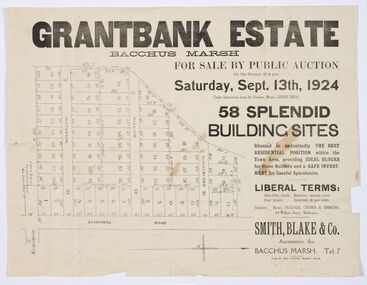
Map - Land Sales Plan, Grantbank Estate Bacchus Marsh, 1924
... Grant Family Bacchus Marsh Printed paper map Grantbank Estate ...The Grantbank Estate was a parcel of land close to the centre of the shopping area of Bacchus Marsh which was sub-divided and offered for sale in 58 lots on the 13th September, 1924. It comprised an area of 15 acres, being a portion of the Millbank Estate which had been in the hands of the Grant family for 75 years. The lots had frontages to Gisborne Road, Patterson, William and Sutherland Streets. This was a significant sub-division of land and represented a major expansion of residential housing in Bacchus Marsh in the early 20th century.This land sale map is a typical example of housing estate land sales advertising maps produced by real estate agents in this era. The map is significant for the detailed information it provides about when and where land was sold for new housing estates in Bacchus Marsh in the early twentieth century.Printed paper mapland sales bacchus marsh, land subdivsion bacchus marsh, housing estates land sales bacchus marsh, grant family bacchus marsh -
 Bacchus Marsh & District Historical Society
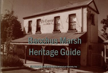
Book, Bacchus Marsh Heritage Guide
... in the town and surrounding district of Bacchus Marsh. Photos and maps ...Publication details: Bacchus Marsh Heritage Guide, 2nd Rev Ed. Published by Bacchus Marsh & District Historical Society, Bacchus Marsh, Vic, 2003. A guide book to heritage places and historical buildings in the town and surrounding district of Bacchus Marsh. Photos and maps are included to identify each place or building. Each site includes a description of its main features and historical or cultural significance. Places of natural heritage significance are included. A previous less extensive edition was published in 1997.Printed book. 160 pages. BMDHS Location: AR/SU4non-fictionPublication details: Bacchus Marsh Heritage Guide, 2nd Rev Ed. Published by Bacchus Marsh & District Historical Society, Bacchus Marsh, Vic, 2003. A guide book to heritage places and historical buildings in the town and surrounding district of Bacchus Marsh. Photos and maps are included to identify each place or building. Each site includes a description of its main features and historical or cultural significance. Places of natural heritage significance are included. A previous less extensive edition was published in 1997.historic buildings bacchus marsh, historic sites bacchus marsh, bmdhs publication -
 Bacchus Marsh & District Historical Society
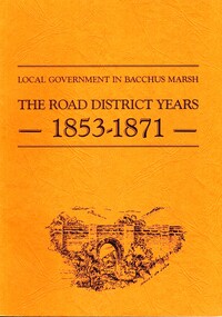
Book, John Lloyd, The Road District Years, 1853-1871: Local Government in Bacchus Marsh
This work describes the early evolution and history of local government in the Bacchus Marsh area. Local government bodies in Victoria and in other places had their origins in committees and local boards which were established to regulate over pressing local issues, raise revenue, and expend it in a limited range of social and economic ways. The early areas of responsibility were dominated by the need for local roads and this book primarily looks at this period of local government history in the Bacchus Marsh area. Overtime the range of areas local government bodies took responsibility for expanded and this work begins to trace this transformation in its earliest stages. It is a fascinating and detailed account of the early history of local government in Bacchus Marsh containing many amusing anecdotes among the wealth of administrative historical data. The author who was at one time an employee of the Shire of Bacchus Marsh has drawn directly from the early local records such as minutes of meetings, records of expenditure, newspaper reports and notices in the Victoria Government Gazette.Soft cover foolscap size book. 128 pages with b & w illustrations, maps and plans. No publisher is indicated in the work but it is likely to have been privately published by the author John Lloyd. Year and place of publication is 1986, Bacchus Marsh, Victoria.non-fictionThis work describes the early evolution and history of local government in the Bacchus Marsh area. Local government bodies in Victoria and in other places had their origins in committees and local boards which were established to regulate over pressing local issues, raise revenue, and expend it in a limited range of social and economic ways. The early areas of responsibility were dominated by the need for local roads and this book primarily looks at this period of local government history in the Bacchus Marsh area. Overtime the range of areas local government bodies took responsibility for expanded and this work begins to trace this transformation in its earliest stages. It is a fascinating and detailed account of the early history of local government in Bacchus Marsh containing many amusing anecdotes among the wealth of administrative historical data. The author who was at one time an employee of the Shire of Bacchus Marsh has drawn directly from the early local records such as minutes of meetings, records of expenditure, newspaper reports and notices in the Victoria Government Gazette.bacchus marsh shire council, local government bacchus marsh history -
 Bacchus Marsh & District Historical Society
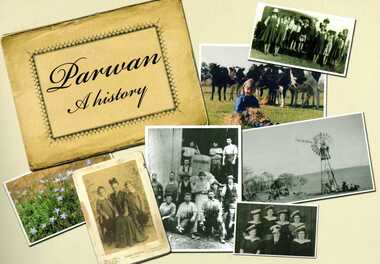
Book, Parwan: A History, 2010
Explores the history of the small farming community on the outskirts of Bacchus Marsh. It contains a plethora of fascinating details about the early years of this farming community from the 1830s until the early 2000s. There is a brief section at the beginning which looks at the history of the area prior to the colonial era. The book contains numerous sections about families and individual people who have lived in the Parwan area and includes many images of places and people. Citation: Parwan: A History by Dianne Van Leuvan. Published by Parwan History Group, Bacchus Marsh, Vic., 2010.Paperback printed book. 128 pages. with illustrations and photographs, some coloured. Includes facsimiles, maps, and index. Includes a separate folded sheet inside a pocket which has a reproduction of a map of the Parwan Parish in the County of Grant. On the reverse of this sheet are two reproductions. One is a land auction plan for February 1910 advertising the sale of portions of land from the Nerowie Estate. The other reproduction is a section of a map showing some of the blocks of land in the Nerowie Estate which has the heading, 'Nerowie Titles 1898'. A pocket inside the back cover contains a separate booklet which is an index, and two pages of 'Additional Information'.non-fictionExplores the history of the small farming community on the outskirts of Bacchus Marsh. It contains a plethora of fascinating details about the early years of this farming community from the 1830s until the early 2000s. There is a brief section at the beginning which looks at the history of the area prior to the colonial era. The book contains numerous sections about families and individual people who have lived in the Parwan area and includes many images of places and people. Citation: Parwan: A History by Dianne Van Leuvan. Published by Parwan History Group, Bacchus Marsh, Vic., 2010.parwan vic. history -
 Bacchus Marsh & District Historical Society
Map, Lerderderg District Proposed Irrigation and Water Supply Trust (B) Plan Showing Proposed Works
The 1886 Irrigation Act in Victoria introduced the first legislation in Australia designed to enable the creation of a detailed scheme for agricultural irrigation. Part of the legislation saw the use of government funds for local irrigation projects. These local projects were managed by local irrigation trusts. The Lerderderg Irrigation and Water Supply Trust was formed in 1890. This map depicts the proposed area of the Trust and proposed works such as channels and weirs.Printed paper map of the proposed Lerderderg District Irrigation and Water Supply area showing proposed works. The map scale is 40 chains + 1 inch. The Lerderderg District lies within the Parishes of Korkuperrumul and Merrimu in the County of Bourke. At the top of the map above its title is the letter 'B; in capital lettering. A series of proposed channels are indicated on the map in red lines. A proposed weir site and alternative weir site are also indicated on the map. irrigation, water supply, lerderderg irrigation and water supply trust -
 Bacchus Marsh & District Historical Society
Map, Lerderderg District Proposed Irrigation and Water Supply Trust (C). Plan showing overlap in boundaries of the Trust District
The 1886 Irrigation Act in Victoria introduced the first legislation in Australia designed to enable the creation of a detailed scheme for agricultural irrigation. Part of the legislation saw the use of government funds for local irrigation projects. These local projects were managed by local irrigation trusts. The Lerderderg Irrigation and Water Supply Trust was formed in 1890. Printed paper map of the proposed Lerderderg District Irrigation and Water Supply. Plan showing overlap in boundaries of Trust District referred to in Mr Burke's report. The Lerderderg District lies within the Parishes of Korkuperrumul and Merrimu in the County of Bourke. At the top of the map above its title is the letter 'C; in capital lettering. A note on this map states: 'Portion of Bacchus MarshUrban District included in area of proposed Trust District shown by hatched shaded lines thus /////////////irrigation, water supply, lerderderg irrigation and water supply trust -
 Bacchus Marsh & District Historical Society
Map, Lerderderg District Proposed Irrigation and Water Supply Trust (A). Plan showing boundaries of Trust District
The 1886 Irrigation Act in Victoria introduced the first legislation in Australia designed to enable the creation of a detailed scheme for agricultural irrigation. Part of the legislation saw the use of government funds for local irrigation projects. These local projects were managed by local irrigation trusts. The Lerderderg Irrigation and Water Supply Trust] was formed in 1890. This map depicts the proposed area of the Trust.Printed paper map of the proposed Lerderderg District Irrigation and Water Supply. Plan showing boundaries of Trust District. The Lerderderg District lies within the Parishes of Korkuperrumul and Merrimu in the County of Bourke. At the top of the map above its title is the letter 'A; in capital lettering. Scale: 40 Chains = 1 inch.irrigation, water supply, lerderderg irrigation and water supply trust -
 Bacchus Marsh & District Historical Society
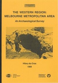
Book, The Western Region: Melbourne Metropolitan Area: An Archaeological Survey
This study aimed to locate and document Aboriginal archaeological sites in the western region of Melbourne. This area was defined by the study as extending out from the western suburbs of Melbourne to the Brisbane Ranges and north beyond Bacchus Marsh. The specific aim of the study was to investigate the Aboriginal archaeology of the Western Plains area in the vicinity west of Melbourne. The Bacchus Marsh, Melton and Werribee shire boundaries of the time defined the areas of the study. The study contains extensive lists of the types of artifacts found the the locations where they were found.Soft cover foolscap size book. 96 pages with b & w illustrations, images and maps (some folded). Part of Occasional reports series (Victoria Archaeological Survey) ; No. 27. Published by Department of Conservation and Environment, Melbourne, 1990. Author, Hilary Du Cros. BMDHS Loc. AR/SU5This study aimed to locate and document Aboriginal archaeological sites in the western region of Melbourne. This area was defined by the study as extending out from the western suburbs of Melbourne to the Brisbane Ranges and north beyond Bacchus Marsh. The specific aim of the study was to investigate the Aboriginal archaeology of the Western Plains area in the vicinity west of Melbourne. The Bacchus Marsh, Melton and Werribee shire boundaries of the time defined the areas of the study. The study contains extensive lists of the types of artifacts found the the locations where they were found. aboriginal australians victoria western plains, aboriginal artifacts, archaelogical sites victoria western plains, aboriginal artifacts bacchus marsh region -
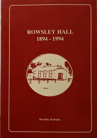 Bacchus Marsh & District Historical Society
Booklet, Rowsley Hall 1894-1994
Rowsley is a rural locality 6km south-west of Bacchus Marsh. It is a very small community and the Rowsley Hall has been a community meeting place for over 100 years. This history tells the story of the origin of the Hall and its place in the community's history for its first 100 years. Citation: Rowsley Hall, 1894-1994, by Dorothy Pedretti. Published by Bacchus Marsh and District Historical Society, Bacchus Marsh, Vic., 1995?A small booklet. 36 unnumbered pages. Stapled binding. Contains black and white photographs, maps and facsimiles of documents. BMDHS Loc: AR/SU5/Pamphlets Box 4Rowsley is a rural locality 6km south-west of Bacchus Marsh. It is a very small community and the Rowsley Hall has been a community meeting place for over 100 years. This history tells the story of the origin of the Hall and its place in the community's history for its first 100 years. Citation: Rowsley Hall, 1894-1994, by Dorothy Pedretti. Published by Bacchus Marsh and District Historical Society, Bacchus Marsh, Vic., 1995?rowsley victoria history, halls, rowsley hall -
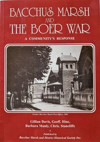 Bacchus Marsh & District Historical Society
Book, Bacchus Marsh and the Boer War: A Community's Response
An account of the impact of the Boer War upon the community of Bacchus Marsh. Like many communities across Australia Bacchus Marsh saw a number of men enlist in the military forces and participate in the conflict in South Africa between Great Britain and its allies such as Australia against the Boer forces in South Africa in the early 1900s. This work documents this history from the perspective of the individual soldiers involved and the way the community responded to this conflict. Citation: Bacchus Marsh and the Boer War: A Community's Response. By Gillian Davis, Geoff Hine, Barbara Manly and Chris Stancliffe. Published by Bacchus Marsh and District Historical Society, Bacchus Marsh, Vic., 2001.A printed book published in paperback edition. 92 pages, with illustrations, portraits, and maps. BMDHS Location: AR/SU4non-fictionAn account of the impact of the Boer War upon the community of Bacchus Marsh. Like many communities across Australia Bacchus Marsh saw a number of men enlist in the military forces and participate in the conflict in South Africa between Great Britain and its allies such as Australia against the Boer forces in South Africa in the early 1900s. This work documents this history from the perspective of the individual soldiers involved and the way the community responded to this conflict. Citation: Bacchus Marsh and the Boer War: A Community's Response. By Gillian Davis, Geoff Hine, Barbara Manly and Chris Stancliffe. Published by Bacchus Marsh and District Historical Society, Bacchus Marsh, Vic., 2001.bmdhs publication, south african war 1899-1902, boer war 1899-1902, soldiers bacchus marsh vic. -
 Melton City Libraries
Photograph, Edna Barrie, 1920, 1924, 1933 and 1940
SUMMARY - Edna (Myers) Barrie, 1918 – 2018, Profile Early Life Edna was born at Melton and delivered by Hannah Watts. Her mother Martha walked in the dark at night with her basket under her arm to the bridge over the Toolern Creek Bridge and into Sherwin Street to the corner of Yuille Street to Hannah’s house Lynch Cottage. Martha’s husband was away shearing and eventually heard the news of the birth of their blue eyed third child and second daughter. She was born into a family that was surrounded by music; her father played the “squeeze box” and mother the mouth organ. From an early age the family were aware of the great composers, a framed picture of Beethoven, Chopin, Schubert and Wagner hung above the door to the lounge room of their 4 roomed cottage, the room where the piano stood. Her life on stage started as a singer aged 6 years at the Melton Mechanics Institute Hall. Edna was born with a natural ear for music learning piano and singing from her older sister Marjorie who became an accomplished pianist and soloist and renowned music teacher in Melton and district. In the 1920s and 1930s concerts at the Melton Mechanics Institute were regular events were the local talent was fostered. The Myers children, like other children of Melton and Rockbank, studied singing, piano and elocution, sat examinations, entered in competitions in South Street Ballarat, Footscray and Melbourne. In 1929 a Sacred Concert was broadcast by 3AR from the Hall as part of the Back to Melton Celebrations. Marjorie Myers performed two of the items on the piano. Edna attended Melton State School 430 from 1924 – 1933. Her father Fred had also attended the same school. In 1924 the School staged Cinderella at the Melton Mechanics Institute Hall with a cast of 33 students. After completing her education a Melton she boarded in South Melbourne and attending Melbourne Girls High School (MacRobertson Girls High School), a school which recognized her musical attributes. She travelled home on the train on the weekends, sometimes getting off at Rockbank to save a few pennies in fares. Working life The early 1930s the Depression was a difficult time for a young woman to find work. Jobs were often menial and given to the youngest and therefore cheapest applicant. She worked as sales assistant at Polonskis and Myer in the city, and Irvines Modes in Footscray. Working to 1pm on Saturday, and when held up by a customer meant missing the train home. While at Myer Department store she lived at home and rode her bike to the Melton railway station. On one occasion she had a nasty fall when a part of her bicycle came loose causing the bike to crash rendering her concussed and injuring her nose. During the 1930s she was given a camera “a little snap” by Mrs Kelly her landlady. This began her interest in photography documenting family life at their “Burnbank” home. Musically, while at Myers she participated in annual performances held at The Kings Hall and the Myer Mural Hall. Working in the basement at Myers she was often embarrassed when her name was called, customers assuming she belonged to the Myer Family. Ken Myer worked in the basement at the same time handling the ‘Wheeler’, a wicker basket used for moving goods around the store. The family philosophy was for the children to start at the bottom and work their way up. Social life Social life in her teenage years was connected also with Scots Presbyterian Church. She attended Sunday School classes and received book prizes for attendance. She loved to read and welcomed the times when she received new book. She took part in the Sunday School Anniversaries and was presented with a Bible from the Superintendent, Henry Robinson for her assistance with the music. Marriage and War years In 1941 Edna married Ernest “Bonnie” Barrie. War in the Pacific was soon to break out. While in Sydney on their honeymoon they met up with Jim Barrie who was on his way to Canada via Hawaii just missing Pearl Harbour by two days. Jim became a Spitfire Pilot and joined the RAF and was based in England. He returned to Australia later in RAAF to fight the Japanese off the coast of New Guinea. The three eldest Barrie brothers were farmers and food producers and were thus except from military service. Edna and Bon were members of the VAOC- Volunteer Air Observers Corp entailing being rostered on duty as plane spotters. The women took shifts during the day and the men at night which involved staying overnight in the Shire Offices. Later the spotting tower was built in the plantation opposite the Post Office. Edna and Bon carried on with this from their home in Ferris Rd when the threat of invasion had ceased Community life Community life in Melton revolved around fund raising events for the Melton Mechanics Institute for the War effort and keeping up with maintenance for the Hall. In 1944 the Minister for Health gave approval for the Shire of Melton to open and Infant Welfare Centre inviting Edna to form part of the Committee with seven other women. In 1948 she was President of Melton Branch of the Victorian Health Centres Association. She volunteered this use of her car driving the person in charge, Sister Smith to visit mothers and their babies. In 1963, along with Betty Jones and Isabel Snell, Edna was instrumental in forming the 1st Melton Cub Pack and later supported the formation of the 1st Melton Scouts. During 1963 – 1968 she completed the Australian Boy Scout Association Cub Pack Preliminary Training and achieved her Wood Badge. Country Women’s Association In 1944-1996 she was a member of the Melton Branch Country Women’s Association (CWA), Melton Branch, Secretary of the Branch in 1945 – 1946 and Branch International Secretary 1970-1971. She worked with choir, music and drama interest groups within the branch attaining both first and second place in 1959, second place in 1952 Exhibition and second in Music in 1960 in the state. She was involved in their handicraft craft events, fund raising and musical events and singing competitions. During the 1950s she trained Trios and Quartets in part singing for the CWA competitions in Ballarat and Melbourne. It was at this time that she developed her skill as a conductor and trainer of choirs. She later auditioned for the Victorian Choir for alto parts believing she would stand a better chance of being chosen, because of her ability to sing in natural harmony. In 1962 she participated in the Tenth Australian Country Women of the World (ACWW) Triennial Conference “Australia Presents: CWA Massed Choir” in the Melbourne Town Hall. This event was recorded by Super Sound Spotlight on 45 extended play vinyl record. The songs were Australian music and words, for example The Silver Stars are in the Sky, The Graceful Swaying Wattle and Kookaburra. Edna continued with her interest in the Victorian Choir regularly meeting at the CWA Headquarters in Toorak for rehearsals. In 1974 she took part in the Australian Choir at the fourteenth Triennial conference of the ACWW Interfaith Service held at the Perth Concert Hall on the 13th of October. Arts and Culture Edna was also in the Choir of 3KZ Carols by Candlelight at the Myer Music Bowl in 1963 and 1964. Melton Choral Society. Edna was Director and Conductor in the 1970s performing at many community events such as Carols by Candle Light, Church Services, Easter and Palm Sunday services, Mothers Union and the 1976 Community Services Week Combined Church Service. The October – November 1978 Program covered the following: songs from the Musicals, Choral and Solo with Narratives, Guest Instrumental Item, Recitation Negro Spirituals and Australian Songs. Her involvement with church choirs included the Scots Presbyterian Church Choir Easter and Christmas performances and the 1967 Centenary Service. In 1980s the Melton Uniting Church Sacred Music Performances included The Crucifixion by Stainer, The Olivet to Calvary and other church Hymns. Edna was Musical Director of the Melton Amateur Theatrical Society and worked on performances in collaboration with Mabel Rogers on script and musical interpretation. Melton and District Historical Society Annual Art and Craft Show. First held in Melton Mechanics Institute Hall in 1973, it later took place in the in the Melton Community Hall. The Art Show was also run in conjunction with other community organizations such as Rotary and Girl Guides. Community history and research Melton streetscape and society Over 20 years commencing in the 1970s, Edna undertook extensive photographing of the changing streetscape of Melton’s High Street. She anticipated the impact of change on the community during the time of Melton’s rapid transition from a small farming district to a large urban community and this led to her extensively document and photograph many of the structures and landscape features of the township that have since been lost. She also meticulously recorded much of the contemporary life of the town and has left a significant legacy of archival material. Melton State School 100 Years Celebration, October 1970 Co-author with Mabel Rogers “The First 100 Years, 1870 – 1970” Assembled a collection of School Class Photograph and identified and compiled lists of names for future school history. She also assembled a photographic display for the 125th anniversary in 1995. Melton and District Historical Society (M&DHS) Foundation Member, 1968 Held President and Secretary positions from its inception Research associated with the classification of Heritage buildings Christ Church Classification C Scots’ Presbyterian Church Classification D Set up the storage and Catalogue system in the Office at the Willows Organised society visits to Heritage sites in and beyond the Shire of Melton, including Stathtulloh, Eynesbury, Deanside, ToolernVale sites including Merrywood (now demolished) Staughton Vale, Chirnside, Point Cook, Shwerkolts Cottage. 1970 – 1983 Melton and District Historical Society Letterhead. Staughton Memorial Light from early newspaper cutting in its location before restoration to present location. Sketch by Wendy Barrie. Designing and printing pamphlets, stationery, and other sale items with Willows title. M&DHS street naming research for new housing developments (1970 – 2000). Collaborated with Mary Tolhurst to research the names of early landowners and pioneer families connected to the first settlers. Researched Aboriginal names for inclusion on lists submitted to developers. An early example is the naming of Kuranjang and the street names associated with the McPherson family. Plains of Promise (Shire of Melton history) by Joan Starr (1985). Edna assisted with Historical Society materials and contributed her own research and photographs. Contacted and organised for Hubert Opperman to launch the book. (She was also present at his last bike ride at Rochester in 1995.) Western Metropolitan Groups of Historical Societies. Member attending meetings and representing Melton, also hosted the Group at Melton The Willows Member of the Committee of Management for the restoration of the “Willows” house the establishment of The Willows Park 1982 March - Official Opening of the Willows Park- Preparation and planning for the event. Involved in the collecting of items in the furnishing of the display rooms in the Willows house. Donated items and furniture from the Myers and Daley family houses. (19th century) Machinery Shed Establishment. Involved with Jeff Robinson in the construction and collection of machinery display Other significant sites Championed and participated in the restoration and preservation significant sites in Melton, including: restoration of the Staughton Memorial Light and its return to its present site restoration of the Pykes Grave (using EW Barrie earthmoving equipment) restoration and reconstruction of Dunvegan restoration and reconstruction of Macs Cottage, the management and Caretakers residence Melton State School War Memorial Gates removed from Unitt Street entrance and relocated to the Willows Park Donated the Barrie family single furrow plough which was standing at the Court House Plaza. It removed and to Council Depot and later missing. The plaque was taken to the Willows. Jimmy Melrose (aviator) cairn restoration at crash site in Melton South Donald Mackintosh (Olympic gold medallist marksman) grave site at the Melton Cemetery (Historical items held by the Myers family collection.) Houdini first flight at Diggers Rest. Edna’s father was shearing at Diggers Rest at the time and witnessed the flight. She attended the 90 year anniversary of the event at the site in 2000. Radio and electronics Edna’s husband Bon interest in wireless communication dates in the 1920s with the building of a crystal set in the early days of public broadcasting. At the Back to Melton Celebrations in 1929, 3AR broadcast a concert from the Melton Mechanics Institute on the 20th February at 8pm featuring Footscray City Band, James Hill baritone, Vera Carew Soprano, James Foran Tenor, Marjorie Myers Piano, and James Williamson Entertainer. Accompanists: Miss Agnes Ross and Mrs James Hill. The Myers children had recordings of their piano playing made onto the aluminium records, Martha Myers’ voice can be heard introducing an item. These were made in a studio in Melbourne. Marjorie was given a upright Gramophone by Donald Mackintosh in recognition of her talent and her contribution to the cultural life of Melton. The family were then able to listen to 78rpm recordings of the famous classical recordings. The turntable was hand wound metal stylus needles had to be regularly replaced. The aluminium disk needed a bamboo needle to prevent damage to the surface. Before electricity was introduced to Melton in 1939 the Mechanics Hall relied on generators to produce electricity. Bon Barrie, being mechanically minded, built a public address system for be used a community functions at the Hall and Recreational Park. By 1939 this was up and running and used for over three decades. A large Collection of 78rpm records provided music for dances, marching, parades and any public event needing music and microphones. The early system was portable and worked on batteries. CFA Radio Communication In the 1950s with the introduction two-way HF and later VHF very high frequency radio sets. Melton Rural Fire Brigade was part of the Bacchus Marsh Group. Radio sets where located in the Melton Fire Truck, and in the house of the Barrie family at Ferris Road. This was an ideal location to observe a 360 degree view in all directions when smoke appeared on the horizon. An antenna was erected beside the house. The set OX 7 was located in the kitchen and monitored 24 hours by the family. When an electrical fire occurred at the junction of the electricity to the house there was time to radio the fire station and summons the men working in the paddocks, thus saving the house from possible destruction. With the introduction of UHF – ultra high frequency Vinten Radios the signal was clearer and static and interference lessened and radio traffic became easier to read, and reduced noise levels in the household. VL3 LY Radio Base became the Group Headquarters was established in 1967. By 1970 the Brigades were: Melton, Rockbank, Sydenham, Toolern Vale, Diggers Rest, Truganina, and Werribee. In 1974 when the family moved to First Avenue, another antenna and a small building were erected adjacent to the residence and used to house the equipment, maps. Radio traffic consisted of regular schedule times and communication with adjoining groups of brigades such as Bacchus Marsh, Mt Macedon and Little River Groups. Many of the brigade and group base radios were situated in private residences and operated primarily by fire fighters wives who held the position of Communications Officer, either registered as a brigade member or informally. Edna was never registered as an operational brigade member but operated informally as an assistant to her husband Bon. She was however a member of the Melton Fire Brigade Ladies Auxiliary from its inception in 1968, a non-operational position. Edna kept up to date with radio procedure following the 1967 handbook; preparing maps, plotting compass points and taking notes on weather forecasts from the SA Border and Western District. Daily notes were taken in anticipation of fire warnings. These log books and daily radio traffic were incidental to the regular radio schedules. Emergency turnouts noted, burning off times and predicted location of smoke. In the summer fire season all TBF (total fire ban days were recorded.) In times of emergency the Barrie family assisted Bon the base radio operator to plot the position and location of fire trucks and to help clarify garbled radio traffic, keep notes and make telephone calls. These log books are held in the EE and EW Family Archive. Melton Uniting Church Edna founded the Church Opportunity with Maisie Robinson in 1975 in the Melton South Methodist Church building. Methodist and Presbyterian Churches of Melton had combined severing their long held connection with Bacchus Marsh. A Manse had been recently built for the Melton Minister. At a Parish Committee meeting at the Melton South Church it was suggested to use the building as an Opportunity Shop. It opened in July 1975, and it raised $1,600 contribution to the church budget in 1976. In 1977 The Uniting Church in Australia was formed and the Melton South Uniting Church Opportunity shop continued to go from strength to strength expanding the buildings providing the welfare needs of the community. Archive Set up by Edna Catalogued items dating from 1857 Minute Book and set ongoing system and storage of items of heritage. Melton Un Awards and recognition of service to the Melton community Rotary Award for Community Service, 1980 Victoria 150th Anniversary Celebrations contributions, 1985 Life Membership of the Melton and District Historical Society (M&DHS), 1989 Extra-Ordinary Contribution for years of service to M&DHS, 1992 Long Service for Exceptional Service MD&HS, 1993 Royal Historical Society of Victoria Award of Merit, 1997 Shire of Melton Certificate of Appreciation for continued support and dedication as a member of MD&HS to the preservation of Melton’s History, 1998 Centenary of Federation Peoplescape (Canberra) Melton Shire nomination, 2001 Uniting Church Melton Life Membership of the Opportunity Shop Uniting Church in Australia Commission for Mission for 30 years of hard work and dedications to the Uniting Church, 2007 Uniting Church Adult Fellowship Certificate appreciation in recognition of valuable support through the “Sammy” Stamp Fund Neighbourhood Watch 5 year award Photographs of Edna at different ageslocal identities -
 Melton City Libraries
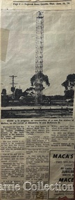
Map, Mount Cottrell Fire group, Unknown
"In 1966, the Mount Cottrell Fire Brigades Group was formed as a way of consolidating the smaller groups around Melton, Rockbank, Toolern Vale, Sydenham, Truganina and Werribee. Its headquarters were established at the home of Ernest ‘Bon’ and Edna Barrie in Ferris Road, Melton. Captain Bon Barrie was a member of the Melton Fire Brigade and elected group and communications officer of the new Mount Cottrell Brigades Group". Fire Brigade Meeting 14th September held at Rockbank Formation a new Group in Region 14 Present: R/O H Rothsay, Assistant R/O R Orchard Tru? G Summerton Purpose of Group The pooling of the equipment in the area should be co-ordinated under one leader. The Brigade and private equipment should be co-ordinated under one leader. Formation was carried unanimously. To be called Mt Cotterill Group. Rockbank nominated Captain E W Barrie elected, Secretary K Watt Toolern Vale. Names listed C/O K L McNaughton Anakie Group COO/O R B Chirnside Lieut J Richmond Capt E Gillespie Toolern Vale Eddie L/ T S Atkin Stan L/T B Storey Bert Sec K Watt Keith Capt E W Barrie Melton Bon L/T K Gillespie Keith A Gillespie Arthur L/T G Lunson George L/T J Robinson Jeff Capt A Marquand Truganina Alan L/T I Cowie Ian Sec T Gard Tom Capt G Harrison Rockbank a/ps G Harrison N Harrison N Fisher a/ps S Hirt Melton Steve Pres M Chomley Sydenham Capt S Hughes Stan Capt L Waterson Werribee Lex Res/o J Hanson G/O S Cooper Bacchus Marsh Syd P/GO W Lidgett Wal Pro/O D Dunton G/O T Healy R C [Mt Macedon] Tom Reg Sec G Douglas Hand written notes of Edna Barrie Typed by Wendy Barrie Maps of the Mt Cottrell Fire groupemergency services, maps -
![Map, Plan of Town Allotments Bacchus Marsh [1873]](/media/collectors/5e461d8021ea67224c82f2a1/items/677a8ee7ab7bb47995c5573f/item-media/677a8fdeab7bb47995c55b56/item-fit-380x285.jpg) Bacchus Marsh & District Historical Society
Bacchus Marsh & District Historical SocietyMap, Plan of Town Allotments Bacchus Marsh [1873]
... Bacchus Marsh Victoria Maps... Streets, are also shown on this map. Land Sales Bacchus Marsh ...James Young was a prominent businessman, land owner and public figure in the early colonial period of Bacchus Marsh. After his death in 1871 land remaining from his estate in Bacchus Marsh was sold at auction in 1873. The sale of his estate included the substantial stone residence in Bennett Street which later became known as 'Stone Villa'. The sale of his land in 1873 was conducted by local auctioneer James Crook. 29 allotments were advertised for sale, although the plan for the sale indicated 30 allotments. The sale notice in the Bacchus Marsh Express of 11 October 1873 noted that the allotments were " in the very centre and heart of the most populous and business portion of the township, at the same time being the only remaining portion of the business block available for purchase by public sale, which fact intending purchasers should not lose sight of, as the opportunity cannot occur again". The designation of a new street, 'Bennett Street', shown on the plan, is also indicated in the advertising, "In reference to the main street frontages, opposite the Border Flour Mills. The Auctioneer would also direct attention to the plan, showing the formation of a new thorough fare (Bennett street) leading from Young street into Gell street, thus opening up the township on the high, more healthy, and commanding position so much to be desired for private dwellings".An important cartographic document which indicates an early major subdivision of land in the inner urban area of the Bacchus Marsh township. This subdivision lead to the continuing residential and commercial development of the township of Bacchus Marsh in the later part of the 19th century. The location of two well known demolished public structures, the Free Gardeners Hall in Gell Street, and the Old Mechanics Institute Hall (aka the Buffs Hall), on the corner of Young and Bennett Streets, are also shown on this map.A single page paper map showing 30 blocks of land for sale around 1873 in the vicinity of Bennett Street and Lerderderg Street. Described in contemorary sources as a 'lithographed copy'. No scale is indicated. The map is pasted into a bound volume containing 76 maps or plans in total. High resolution digital image stored on BMDHS computer network. land sales bacchus marsh, bacchus marsh victoria maps, james young 1816-1871, bacchus marsh roads and streets, bennett street bacchus marsh -
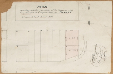 Bacchus Marsh & District Historical Society
Map, Plan showing relative positions of the Gisborne road formation and Mr. Cosgrove's land in Darley. 1907
... . Cosgrove's land in Darley. 1907. Map Shire of Bacchus Marsh ...No background information about the roadworks referred to in this plan has been found. The portion of land referred to as 'Cosgroves' in this plan is located close to the present day Darley Park Recreation Park in Darley, near Bacchus Marsh. The land indicated appears to be close to the corner of Grey Street and Gisborne Road. James Cosgrove who died in 1923 aged 65 owned a farm of 52 acres in this area of Darley.Single page map showing a proposed deviation of the Gisborne road in Darley and its position relative to land owned by Mr. Cosgrove. The land owned by Cosgrove is shaded in pink. No scale indicated. Part of a set of maps which are pasted into a bound volume containing 76 maps or plans in total. High resolution digital image stored on BMDHS computer network. Signature (illegible), Eng, Bac Marsh Shire, 30/9/07bacchus marsh roads and streets, darley victoria maps -
 Bacchus Marsh & District Historical Society
Map, Plan of land purchased by the Bacchus Marsh Shire Council from Mr. T. Low for a deviation of the Melbourne to Ballarat main road. 1877
... . Standfield, Shire Engineer, Bacchus Marsh, 12/4/77 Single page map ...The date of this plan is 1877 and the land indicted on it required for a road deviation is shaded in blue. It adjoins the Korkuperrimul Creek on one side which indicates the land is located just a few kilometers to the west of Bacchus Marsh. Single page map showing a portion of land purchased by the Bacchus Marsh Shire from Mr Thomas Low for the purpose of a road deviation. Land held by David Robertson is also shown on the map. Scale: 2 chains to 1 inch. Part of a set of maps which are pasted into a bound volume containing 76 maps or plans in total. High resolution digital image stored on BMDHS computer network. Surveyed by W. E. Standfield, Shire Engineer, Bacchus Marsh, 12/4/77bacchus marsh roads and streets, melbourne to ballarat road -
![Map, Plan showing proposed deviation of the road through McKenzie's Flat to Bacchus Marsh. [Undated]](/media/collectors/5e461d8021ea67224c82f2a1/items/677d22f37f2053f3e5d500dc/item-media/677d25247f2053f3e5d50950/item-fit-380x285.jpg) Bacchus Marsh & District Historical Society
Bacchus Marsh & District Historical SocietyMap, Plan showing proposed deviation of the road through McKenzie's Flat to Bacchus Marsh. [Undated]
... Bacchus Marsh Roads and Streets Single page map showing a proposed ...The date of this map or plan is uncertain. McKenzie's Flat is a bushland picnic area on the Lerderderg River in the Lerderderg State Park close to Bacchus Marsh. The proposed road deviation shown on this map is very close to a sharp bend in the Lerderderg River which shows an island in the centre of that bend. The name of a landholder, J.B. Perry is shown on the map close to the area of the road deviation.The land shown is identified as within the Parish of Merrimu.Single page map showing a proposed deviation of the road from McKenzie's Flat to Bacchus Marsh. Scale: 5 chains to 1 inch. Part of a set of maps which are pasted into a bound volume containing 76 maps or plans in total. High resolution digital image stored on BMDHS computer network. mckenzies flat bacchus marsh, bacchus marsh roads and streets -
 Bacchus Marsh & District Historical Society
Map, Village allotments, Parish of Myrniong, County of Bourke
... Map Shire of Bacchus Marsh ...Myrniong is a village 9 kilometers west of Bacchus Marsh. Prior to 1863 the area was known as Blow's Flat. This map which was produced in 1903 and according to the catalogue record of this map held at the State Library of Victoria was based on an earlier map created in 1861. The early layout of streets for the village of Myrniong can be seen on this map. The streets shown are, Main Street, Hardy Street, Blow Street, Myrniong Street, Shuter Street, and Blackwood Street. An area marked as a reserve for a school can be seen between Hardy Street and Main Street.A single page paper map. A cadastral parish map of Myrniong in Victoria, showing numbered land allotments. Photo-lithographed at the Department of Lands & Survey, Melbourne, in 1903. Based on an original map created in 1861. The map is pasted into a bound volume containing 76 maps or plans in total. High resolution digital image stored on BMDHS computer network. Surveyed by John Hardy, Surveyor ; photo-lithographed at the Department of Lands & Survey, Melbourne by T.F. McGauran, 24.12.03myrniong parish plan, myrniong parish maps -
 Bacchus Marsh & District Historical Society
Map, Parwan Parish Map, County of Grant, 1909
... Bacchus Marsh Region Parish Plans Parwan Parish Maps Parwan ...A single page paper map showing the map for the Parish of Parwan in the County of Grant. A cadastral map showing parish boundaries and land ownership. The map is pasted into a bound volume containing 76 maps or plans in total. High resolution digital image stored on BMDHS computer network. Photo-lithographed at the Department of Lands and Survey, Melbourne by T.F. McGauran, 7.7.09. bacchus marsh region parish plans, parwan parish maps, parwan parish plan -
 Bacchus Marsh & District Historical Society
Map, Trentham Parish Map 1905 Copy 1
... Trentham Parish Maps Trentham Parish Plan Bacchus Marsh ...A single page paper map showing the map for the Parish of Trentham in the Counties of Dalhousie and Bourke. A cadastral map showing parish boundaries and land ownership. The map is pasted into a bound volume containing 76 maps or plans in total. High resolution digital image stored on BMDHS computer network. Photo-lithographed at the Department of Lands and Survey, Melbourne by T.F. McGauran 22.3.05 trentham parish maps, trentham parish plan, bacchus marsh region parish plans -
 Bacchus Marsh & District Historical Society
Map, Coimadai Parish Map, County of Bourke. Circa 1890s-1900s
... of Bourke. Circa 1890s-1900s. Map Shire of Bacchus Marsh ...The cadastral Parish of Coimadai, a subdivision of the County of Bourke, lies directly north of the township of Bacchus Marsh. The date of this map is uncertain. T.F. McGauran the person who made a photo-lithographic copy of the map was in charge of photo-lithography at the Victorian Department of Lands and Survey in the late 19th century until about 1910.A single page paper map showing the map for the Parish of Coimadai in the County of Bourke. A cadastral map showing parish boundaries and land ownership. A rectangle shaped area is missing from the centre of the map due to a tear or deliberate excision. The map is pasted into a bound volume containing 76 maps or plans in total. High resolution digital image stored on BMDHS computer network. Photo-lithographed at the Department of Lands and Survey, Melbourne by T.F. McGauran 26.8.[??] NOTE. Photo litho from L.P showing temporary surveys and occupation of land prepared for departmental use onlybacchus marsh region parish plans, coimadai parish maps, coimadai parish plan -
 Bacchus Marsh & District Historical Society
Map, Plan of Land at Bacchus Marsh, the Property of James Young, 1868
... Bacchus Marsh Victoria Maps... Bacchus Marsh Victoria Maps James Young 1816-1871 Masons Lane ...James Young was a prominent businessman, land owner and public figure in the early colonial period of Bacchus Marsh. In February 1868 he offered for sale through the agent W. Anderson 38 blocks of land which ran from the Lerderderg RIver westwards beyond Gisborne Road in the vicinity of the present day Masons Land. The land for sale was described as, 'unsurpassed Agricultural Land, in the immediate vicinity of Bacchus Marsh, varying in size from 2 to 12 acres each'. The sale notice in the Bacchus Marsh Express of 1st February 1868 page 2, also noted that, ' Plans can be seen at Mr. Young's Border Mills Store, and at the Border Inn'. One of the largest and most important land sales in the early colonial period of Bacchus Marsh.A single page paper map showing 38 blocks of land for sale in 1868 in the vicinity of Masons Lane Bacchus Marsh. Scale 11 chains to 1 inch. The map is pasted into a bound volume containing 76 maps or plans in total. High resolution digital image stored on BMDHS computer network. land sales bacchus marsh, bacchus marsh victoria maps, james young 1816-1871, masons lane bacchus marsh land sales -
 Bacchus Marsh & District Historical Society
Map, Blackwood Parish Map, County of Bourke, 1892
... Bacchus Marsh Region Parish Plans Blackwood Parish Plan ...A single page paper map showing the map for the Parish of Blackwood in the County of Bourke. A cadastral map showing parish boundaries and land ownership. The map is pasted into a bound volume containing 76 maps or plans in total. High resolution digital image stored on BMDHS computer network. Photo-lithographed at the Department of Lands and Survey, Melbourne by T.F. McGauran 14.7.92bacchus marsh region parish plans, blackwood parish plan, blackwood parish maps -
 Bacchus Marsh & District Historical Society
Map, Blackwood Parish Map, County of Bourke, 1905
... Bacchus Marsh Region Parish Plans Blackwood Parish Plan ...A single page paper map showing the map for the Parish of Blackwood in the County of Bourke. A cadastral map showing parish boundaries and land ownership. The map is pasted into a bound volume containing 76 maps or plans in total. High resolution digital image stored on BMDHS computer network. Photo-lithographed at the Department of Lands and Survey, Melbourne by T.F. McGauran 21.7.05bacchus marsh region parish plans, blackwood parish plan, blackwood parish maps