Showing 61 items
matching mt beauty land
-
 Kiewa Valley Historical Society
Folder - Clare Roper No. 7, Items of Interest
Clare Roper was a resident of the Kiewa Valley and belonged to the Kiewa Valley Historical Society.Clare Roper collected and collated items of historical interest for the Kiewa Valley Historical Society.Grey plastic front and back cover with black spiral spine with 24 clear plastic sleeves / pages plus 2 sleeves empty. Includes: Roper Family. Thomas Mitchell C.M.G.. North Eastern Dairy Company. Johann Gottfried Scholy's History. Rutherglen's Early Days.The Viticulture College. Botharambo. Pledge of Loyalty (to the Queen). North East Historical Societies. The Land Act 1883. Protection of the Aborigines 1886.clare roper; scrap book -
 Kiewa Valley Historical Society
Photograph Farm Land, Mount Beauty Acreage before Golf Course, Circa 1950
This photograph is a "snap shot" in time circa 1950s detailing the rural environment before the effects of the Kiewa Valley Hydro Scheme altered the basic rural setting of the valley. The golfing fairway was being mapped out on previous grazing land, before the laying of a golf course, for use by the construction workers and auxiliary administration employees of the Victorian State Electricity Commission. This photograph details a dramatic period in time which saw an enormous change to the exclusively rural area of the Kiewa Valley region in the mid 1900s. This change presented both physical and mental challenges to the existing quiet rural inhabitants of the valley. The State of Victoria had to make adjustments to the changing demands imposed by population and industrial expansions. The development of cleaner energy supplies to a growing population has its downside ,which ever way the intrusion into the "natural" landscape is made.Black and white photograph detailing surveyor posts for construction of golf course. Land used, before establishment of the Mount Beauty Village, as farming/grazing cattle and viewed towards Mount Bogong and its Alpine ranges. The photo is on 200gms paper and not on photographic paper.nilmount beauty in the 1940s - 1950s, grazing in the kiewa valley, sec victoria -
 Kiewa Valley Historical Society
Photograph of Kiewa Valley Panorama, Farming lands within the Kiewa Valley in1950s, Circa 1950
This photograph shows how (early to mid1900s), before the establishment of the Mount Beauty "gated" village, the Kiewa Valley was farmed and the scarce population was spread out over acres of productive land. This photograph catches a time before (what appeared to the local farmers as the invasion by a mass of construction workers) when this remote valley was part of a "lay back" rural landscape,occasionally visited by friends and some wayward tourists. The mountain ranges provided an adequate barrier against the way-would traveller. The immigration numbers coming into Australia was still quite small ( due to the "white" Australia policy) which was in force before World War II. After World War II a mass of displaced European refugees and migrants boosted the Australian population and provided for a greater degree of diverse professions and rural related work force.This photograph depicts the borderline in time between an exclusively rural based population and respective activities(early 1900s)to the present (2000 on wards) integrated village, tourist and retiree/holiday area. The time when land was exclusively used in agriculture is over and the impact of cheaper rural produce from Asian markets will see a shift of land useage and population activities. The Kiewa Valley is loosing its hiding place and is becoming more and more a source of untapped residential land. Black and white photograph of farming/grazing land useage, before the establishment of the Mount Beauty Village. Small pockets of residentual houses can be viewed. Road access (unsealed dirt) was typical of that provided in rural regions in the 1950s. The photo is on 200gms paper and not on photographic paper.kiewa valley in the early1900s, grazing in the kiewa valley, sec victoria -
 Kiewa Valley Historical Society
Photograph of Snow Covered Catchment Area Vic, Snow Covered Catchment Area Victorian Alps - 1950s, Circa 1950
This photograph details (early to mid1950s), the Victorian Alpine region when this remote area was part of a "lay back" rural landscape,occasionally visited by recreational adventurers and some wayward tourists. The mountain ranges had provided an adequate barrier against the way-would traveller, but with the opening up of this region by the provision of improved roadways and accommodation facilities, courtesy of the Kiewa Valley Hydro Electricity Scheme, changes such as tourism and its impact upon the "natural" state started to show its side effects (clearing of the land). The expansion of the European immigration numbers (1950s) coming into Australia was increasing after World War II which not only provided increased construction workers to the region but also immigrants who appreciated alpine regions. Some of these immigrants contributed to the expansion of the region and provided for a greater degree of diverse professions and rural related work force.This photograph depicts the borderline in time between an exclusively rural based population and respective activities(early 1900s)to the present (2000 on wards) integrated village, tourist and retiree/holiday area. The time when land was exclusively used in agriculture and Alpine grazing lands is over. The Kiewa Valley is loosing its hiding place and is becoming more and more a source of untapped residential land and winter time recreational adventure lands. The changes brought about by modern technologies involving recreational activities such as hang gliding, gliding (local airstrip), mountain bikes, car rallies and their associated clubs is providing for an increased short term population boost. These together with the attractions for retirees is changing not only the physical nature of the Kiewa valley but also its "soul".This item is a black and white photograph of a section of snow covered catchment area in the Victorian Alps in the mid 1900. It is on 200 gms paper but not on photographic paper and has a white boarder (3 mm).kiewa valley tourism, victorian alps, alternate energy supplies, alpine population growth -
 Kiewa Valley Historical Society
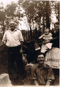
Photograph of Kiewa Valley Pioneer Family, Three Generations of Kiewa Valley Pioneer Family (Coopers), late 1900s'
This historical family photograph spans three generations of the Cooper Family, a pioneer family, still residing in the Kiewa Valley. The large axe held by Pat was a handy tool for pioneer families to chop down trees for land clearing, building sheds and fences, outhouses and fire wood. This photograph was taken during a time where both male and females did some heavy lifting and processing. The rural sector at this point in time was physically a hard location for both sexes. The segregation of the sexes into specific job categories was some times non existent although household "chores" was in the main a woman's domain. The rural sector was in this point of time one which women were highly respected and the unwritten law of providing "assistance" and "reverence" by men in such actions as, socially opening doors, tipping the cap, offering a sturdy arm for support and refraining from doing or saying anything "uncouth" in a woman's presence. It was in a time when women's liberation was just starting to grow strength. Rural areas, on the hole, took longer to interfuse "city" hatched norms of behaviour. This photograph of a pioneer family still residing in the Kiewa Valley demonstrates not only the close protective environment that the valley has on all its inhabitants but also the close bonding that neighbors have towards each other. The term "God's gifted country" fits warmly with all the settlements in the valley. The relatively isolated (physically, visually and communications wise) has since post World War II been whittled away by faster and vastly improved communications with "the outside" world. The strength of commitment to the rural life can be seen in the faces of the family members in this photograph. The proud heritage is displayed without any external pressure. This large black and white family photograph is a reproduction on Fujicolor Crystal Archive Paper manufactured by Fujifilm. It is 200gsm matt finished paper with no borders. On the reverse side, written in pencil "Ted Cooper sitting aged 24-25, Pat Amery (Ted's youngest sister) holding Ted's eldest son Doug and Ted's father John Franklin Cooper(22-8-1892)"john cooper, ted cooper, pat amery, doug cooper, pioneer family kiewa valley -
 Kiewa Valley Historical Society
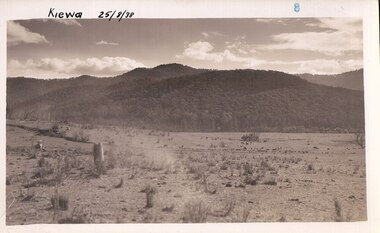
Black and White photograph of Road Making Machinery, Kiewa Road Making 25/08/1938 No. 2, 25/08/1938
Construction of the main road from South Tawonga to the Bogong High Plains, to provide access to the construction sites for the new Kiewa Hydro Electric Scheme, was commenced early in 1938, the work being undertaken on behalf of the commission by the Country Roads Board. For the construction work, the Commission purchased three Caterpillar - model R07 - diesel crawler tractors equipped with Kay Brunerei (Brunner) hydraulically operated trailbuilders (angle dozers). This acquisition resulted from a visit to the United States of America in May, 1937 by the Construction Engineer ( Mr. C.H. Kernot) and Assistant Civil Engineer ( Mr. J.F. Douglas) where they saw this relatively new type of equipment in use. With the co-operation of the CRB, the Commission demonstrated the operation of these machines at Fishermen's Bend on 6th April, 1938. They were then sent to Kiewa where they commenced operation towards the end of the month. From South Tawonga, the route let immediately across the Western Branch of the Kiewa River necessitating the construction of a bridge 100 feet long. By the end of 1939, the excavation had been 'opened up' for a distance of 19 1/2 miles (approx. 31 km.) and of this length, 10 miles (approx. 16 km.) had been surfaced. (see KVHS 0328)The purchase of this type of mechanical equipment in road making was a huge investment, as prior to this most of the work would have been done manually with the use of picks and shovels. Not only were many months of hard manual labour saved, but a very significant amount of time in providing access to the proposed work sites for the new Kiewa Hydro Scheme. This photo is an excellent reminder of how primitive the early machinery was compared to the present but also represents the forward thinking of the State Electricity Commissions engineers in purchasing such innovative equipment.A black and white photograph of road making near Mt. Beauty in 1938. Mount Beauty hills can be seen in the background with cleared land for grazing in the fore ground.Hand printed in black ink at the top of the photograph is 'Kiewa Road Making 25/8/1938'. On the right hand corner has been printed the number 2. It has been printed on gloss Velox paper.road making, state electricity commission, caterpillar tractor, kiewa, secv -
 Kiewa Valley Historical Society
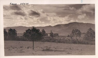
Black and white photograph of farmland, Kiewa, 25/8/38, circa 1938
... Centre 31 Bogong High Plains Rd Mt Beauty high-country ...This photograph was taken in August, 1938 some eight years prior to the establishment of Mt. Beauty as a township. The area was still being used for grazing, and the land was eventually acquired from the local land owners by the State Electricity Commission. The construction of the road, from Tawonga to the High Plains, was commenced in April of this year. This allowed men and heavy equipment to be transported to the work sites for the construction of the Kiewa Hydro Electric Scheme This photograph is important as it shows the upper Kiewa Valley as it was before the establishment of the town of Mt. Beauty. The land has been cleared of natural growth and has been used for grazing cattle. By 1946 housing construction had commenced for the new town of Mt. Beauty and by 1948 street construction in the southern part of the town was completed as far as Hill Street.A black and white photograph of farmland with Mt. Emu in the background. This has been taken from where Mt. Beauty township now stands prior to road making and the erection of houses. A line of trees below the hill line indicates the position of the East Kiewa River. (No. 5 in a set of 8) Handwritten in black ink on the upper left corner of the photograph is the inscription 'Kiewa 25/8/38' and the number 5 has been stamped on the upper right hand corner. On the back is the word 'Velox' which is the name of the photographic paper on which the photo was developed.road construction, kiewa, tawonga, mt. beauty, secv -
 Kiewa Valley Historical Society
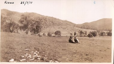
Black and white photograph of farmland, Kiewa, 25/8/38, circa 1938
... as it was before the establishment of the town of Mt. Beauty. The land had ...This photograph was taken in August, 1938 at the time of road making in the area and some eight years prior to the establishment of Mt. Beauty township. The area was still being used for grazing, and the land was eventually acquired from the local land owners by the State Electricity Commission. The construction of the road, from Tawonga to the High Plains, was commenced in April of this year. This allowed men and heavy equipment to be transported to the work sites for the construction of the Kiewa Hydro Electric Scheme. An important photograph as it shows the upper Kiewa Valley as it was before the establishment of the town of Mt. Beauty. The land had been cleared of natural growth and has been used for grazing cattle. By 1946 housing construction had commenced for the new town of Mt. Beauty and by 1948 street construction in the southern part of the town was completed as far as Hill Street.A black and white photograph taken in the upper Kiewa Valley showing farmland with a group of three unidentified people sitting on the grass.Handwritten in black ink is the inscription 'Kiewa 25/8/1938'. In the right corner of the photograph has been stamped the number 6. On the back in a circle, some 14mm across, are the words 'Kodak Print'. The word Velox is also printed on the back.kiewa, mt. beauty, construction, grazing, secv -
 Kiewa Valley Historical Society
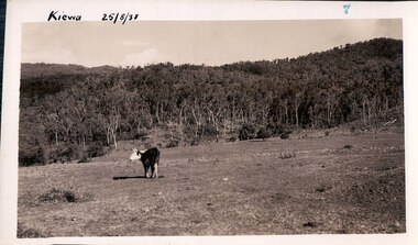
Black and white photograph of farmland, Kiewa, 25/8/38, circa 1938
... of the town of Mt. Beauty. The land has been cleared of natural ...This photograph was taken in August, 1938, some eight years prior to the establishment of Mt. Beauty a a township. The area was still being used for grazing, and the land was eventually acquired from the local land owners by the State Electricity Commission. The construction of the road, from Tawonga to the High Plains, was commenced in April, 1938 and this photograph was taken August, 1938. This allowed men and heavy equipment to be transported to the work sites for the construction of the Kiewa Hydro Electric Scheme. Prior to this access was by bridle trail, either on horse back or on foot. By 1946 housing construction had commenced for the new town of Mt. Beauty and by 1948 street construction in the southern part of the town was completed as far as Hill Street.This photograph is important as it shows the upper Kiewa Valley as it was before the establishment of the town of Mt. Beauty. The land has been cleared of natural vegetation to allow grazing of cattle. Black and white photograph of grazing farmland with one animal standing in the paddock. The area could possibly be where the golf course now stands with the road to the high plains not yet commenced.Handwritten in the upper left hand corner 'Kiewa 25/8/38'. The number 7 has been stamped in the upper right hand corner. It is part of a set of 8 photographs. On the back are the words Velox repeated several times, indicating the type of photographic papergrazing, kiewa, mt. beauty, secv -
 Kiewa Valley Historical Society
Photograph Farm Land, Kiewa, 25/8/38, circa 1938
This photograph was taken in august, 1938 some eight years prior to the establishment of Mt. Beauty as a township. The area was still being used for grazing cattle and the land was eventually acquired from the local land owners by the State Electricity Commission. The construction of the road, from Tawonga to the High Plains, was commenced in April of 1938. This allowed men and heavy equipment to be transported to the work sites for the construction of the Kiewa Hydro Electric Scheme. Prior to this access was by bridle trail, either on horse back or by foot. By 1946 housing construction had commenced for the new town of Mt. Beauty and by 1948 street construction in the southern part of the town was completed as far as Hill Street.This is an important photograph as it shows the upper Kiewa Valley and the site for Mt. Beauty as it was before the establishment of the town. The land has been cleared of natural vegetation and used for grazing cattle.Black and white photograph of farmland, cattle in the distance, hills in the backgroundHandwritten in the upper left hand corner, in black ink, 'Kiewa 25/8/38'. The number 8 has been stamped in the upper right hand side of the photograph. On the back have been stamped the words Velox, indicating the type of photographic paper.kiewa, mt. beauty, construction, grazing, secv -
 Kiewa Valley Historical Society
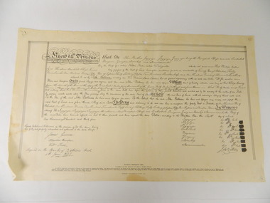
Deed, Batman's Melbourne Deed c1835, Original 6 June 1835. Copied 1966
Facsimile of the oriental in the Latrobe Library of the acquisition of 600,000 acres of land (sites of Melbourne & Geelong) between John Batman & Principal chiefs of Dutteallar native tribe.john batman. -
 Kiewa Valley Historical Society
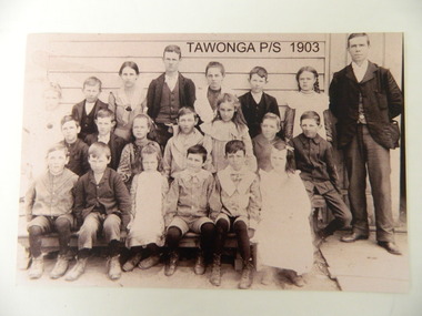
Photo - Copy of Tawonga Primary School 1903, Tawonga Primary School, 1903 - original
Tawonga is in the Kiewa Valley where farmers lived with their families. The school was opened on 27th July 1880 situated on 8 acres near the current township of Tawonga. This school was erased by fire in 1900 and all records were destroyed. The school then moved to the old Tawonga Hall. In 1910 the school was shifted to its present site on 3 acres of land donated by Frank Cooper. The school building and attendance continued to grow especially during the construction of the Kiewa Hydro Electric Scheme. Historic: Tawonga Primary school has educated the local farming and town children for many years. It is an excellent source of the names of the local families in 1903. The photo is taken outside the Old Tawonga hall where the school was situated in 1903 and shows the clothing worn by children and teachers at the time.Teacher and 20 students in school photo. "Tawonga Primary School 1903" added digitally when the photo was copied. There is a typed list of all names.Names of students. Back Row: Charlotte Cooper, John Cooper, Ada Cooper, Thomas Hollands, Irene Roper, Stewart Hollands, Lily Barnette. Teacher Donald Mc Cance. Centre Row: Edward Trebilcock, Alfred Hollands, Pearl Barnette, Frank Cooper, Nellie Higginson, Bert Roper, Reg Roper. Front Row: Ben Cooper, Raymond Cooper, Myrtle Barnette, Lewis Crotty, John Creamer, Annie Hollandstawonga primary school. education. kiewa valley. cooper family -
 Kiewa Valley Historical Society
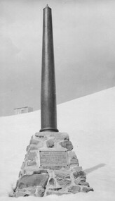
Photo: Memorial on the Staircase Spur Track, Mt Bogong
Mt Bogong is the highest mountain in Victoria. The Staircase Spur track to its top starts at Mountain Creek Road going through forest and continuing above the snow line to grass land. The weather can change very quickly with cloud and snow making conditions dangerous. Large sepia photo of the Memorial in snow on the Staircase Spur Track on Mt Bogong. The Memorial has a plaque attached: Sacred to the Memory / of Georgine Gadsden / Edward Neave Welch / John McRae / who perished here during a blizzard / about August 2nd 1943staircase spur memorial, mt bogong -
 Kiewa Valley Historical Society
Photos - King Family Collection
The King family lived in Tawonga South where my older brother and sister went to school. We lived over the road from Wally Madison's farm. Later when a house became available, we moved into Valley Avenue, Mt Beauty. This is when I turned 5 and started my schooling. It was a long walk for a 5 year old as I remember. Then later we moved to 50 Lakeside Ave. I remember we loved living there as it was close to the school, footy ground and kindergarten. My father, Ted King, wad a carpenter and was involved in the building of many houses in Mt Beauty which was the home for the workers on the Kiewa Electric Scheme. So as they are part of the history of Mt Beauty I thought they may be useful to you as part of the history. The tennis photos, I vaguely remember Lou Hoad and Ken Rosewell giving exhibition matches in Mt Beauty. I may stand corrected on this, but I do remember my parents who were keen tennis players themselves were most excited at seeing these famous tennis players. As I was only 9 when we left Mt Beauty to live in Dimboola I still remember the shock of leaving a beautiful mountainous county side and arriving in a flat farming land next to a desert and seeing windmills One thing I do remember from school is, once a week (or fortnight) the teacher used to come around with a jar of little white pills, of which we were all to take. I really don't know what they were?? or for?? I also remember being taught to swim in the freezing cold river by a Mrs Smith who wore black bathers and wore her hair in a bun...... ...I am now in my 70s My father used to also carve intricate trays and jewellery boxes in his spare time. I think they were used for tennis trophies. by Diane Werner.x33 photos of small black and white photos of the Tawonga, Tawonga South and Mt Beauty - Photos not labelled but described as follows. See each photo for a possible label. A. Tawonga? B. Mt Beauty taken on the road to Bogong ? C. SEC Works D. Industrial buildings with mountains in the background E. Building site with wooden frame and 3 men F. Buildings with power poles G. Building site with lots of huts H. Buildings under construction I. Group of houses in the distance J. Group of houses in the distance K. Group of people in front of a building L. Group of 8 men sitting on timber planks, corrugated iron at back. M.& N. Building site with floor and upright timbers O. Mountain view with camp site in foreground P.& Q. Buiding site, several houses R.5 men at a building site S. portable building on trailer T & U. Mountain view V. Building site W. Group of men, car and mountains in background X. Cows Y. Pigs Z. 2 men standing next to cars. AA. Football players BB. Man painting a corrugated iron building CC. Football DD. Men in front of a building EE Buildings with mountains in background FF & GG Tennis payersHH & II. Electricity infrastructure -
 Kiewa Valley Historical Society
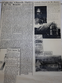
Booklets and Papers - St Joseph's Catholic Church Mt Beauty, St Joseph's Catholic Church Mt Beauty Golden Jubilee 1954-2004
Catholics from Tawonga attended Mass at Dederang the area being part of the Myrtleford parish. With the coming of the State Electricity Commission and the increase in population Masses were said in various schools, homes and halls between Tawonga and Mt Beauty until the completion of St Joseph's ChurchSt Joseph's Catholic Church, Mt Beauty was consecrated on November 7th 1954. The SEC allocated land to each of the churches for them to provide their own places of worship. It was built by volunteers who donated money and their time to raise funds and build the church.1. Booklet with yellow cover, black print and 28 pages back to back held by 2 staples. 2. Booklet "Mass to Celebrate the 40th Anniversary of St Joseph's Church Mt Beauty 1954-1994" 4 pages back to back 3. Papers: vary - 1. A3 sheet with articles from newspapers "Catholic Church Opens At Mt Beauty"; "Catholic Church for Mt. Beauty". 2. x4 A4 sheets typed back to back -"Recalling the first 40 years" 3. St Joseph's Mt Beauty 1968-69 Lawn Cutting Roster 4. Miscellanious st joseph's mt beauty, catholic church, golden jubilee, religion -
 Kiewa Valley Historical Society
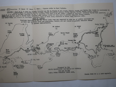
Map - Kiewa Hydro Electric Works Area
An early map of the Kiewa Hydro Electric Scheme Works Area prepared by the SECV for use when requesting access to the area. The regulations are printed regarding permits.During construction of the KHES there were restrictions on access to the area. This map identifies the land marks and states the regulations for entry to the area.Black and white map folded into three showing a legend with the townships, camps, gates and dams marked.Also indicating the roads, rivers, mountains and infrastructure of the KHES. khes works area, map of khes -
 Kiewa Valley Historical Society
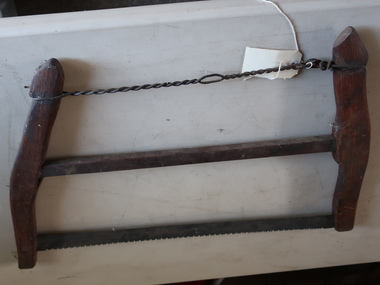
Buck Saw
A bucksaw is a hand powered frame saw similar to bow saw and generally used with a sawbuck to cut logs or firewood to length (bucking).Used by residents of the Kiewa Valley for clearing land, chopping firewood, cutting lumber. Also used while camping because it is portableFormerly UKV 239. Buck Saw with Lightning Tooth Blade. Operated by two men.Ref. Page 10 Tools for all Trade Catalogue. It consists of 3 horizontal bars, the top one being twisted wire and the bottom one being the metal blade with a wood bar in between. They are attached at each end to curved wooden bars. tool for wood, saw, buck saw -
 Kiewa Valley Historical Society
Cross Cut Saws x3
Used to cut down trees and to saw the trunks to length. Used to clear the land.Used by the residents of the Kiewa Valley.A. Combination Tasmanian Pattern and Peg Tooth Cross Cut Saw B. Tasmanian Pattern Cross Cut Saw C. Peg Tooth Cross Cut Saw A crosscut saw is a saw designed for cutting wood perpendicular to (across) the wood grain. It cuts when pulled in both directions. The two man crosscut saw has wooden handles that fit into a steel socket at each end. The Tasmanian has a different tooth pattern to the Peg Tooth saw.crosscut saws, two man saws -
 Kiewa Valley Historical Society
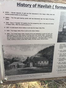
Papers - Havilah Cemetery, Havilah Cemetery Formerly Running Creek Cemetery
In 1889, 24 residents of the Running Creek and surrounding district submitted a petition to the Minister of Lands, Melbourne requesting land for a cemetery. Their request was granted. The Cemetery was decommissioned in the early 1950s and the last trustee for the cemetery died in 1986. There is a wooden fence around the boundary (May 2024). One paper lists 29 names in the Burial Register 1861-1948. The last two sheets record the history as a timeline from the 1850s to the 1900s. Havilah was a gold mining settlement from the 1850s located 20km west of the Kiewa Valley and in the Ovens catchment near Myrtleford.Five black and white A4 pages stapled together. Copies of the sign erected at the gate of 'Havilah cemetery formerly Running Creek Cemetery'. Also the 'History of Havilah formerly Running Creek'havilah, running creek, cemetery -
 Kiewa Valley Historical Society
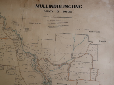
Parish Map - Mullindolingong, County of Bogong
The Department of Lands regularly updated the occupiers with leases or licences of the land.The names of the early settlers of the Kiewa Valley occupying land by lease or licence are shown. Many of these familie's descendants still live in the Kiewa Valley.Government (Lands Department?) cloth map showing the leases or licenses of occupiers of the land in the valley. The Kiewa River is shown in blue and roads in yellow. There is no date on the map.parish of mullindolingong map, settlers of the kiewa valley -
 Kiewa Valley Historical Society
Maps - Kiewa Valley Parish Maps x3 and Kiewa Area Planimetric Map x1
Planimetric maps are 2 dimensional representations of the Earth's surface, showing the location and spatial arrangement of features such as roads, buildings, and bodies of water. The parish maps show the occupiers with leases or licences of the land. These are updated by the Department of Lands regularly. The names of early settlers of the Kiewa Valley occupying land by lease or licence are shown. Many of these familie's descendants still live in the Kiewa Valley.1. Kiewa Area Planimetric Map (photo) 2. Wermatong, County of Bogong Parish Map 3. Mulllindolingong, County of Bogong Parish Map 4. Mullagong, County of Bogong Parish Map All black and white kiewa valley. parish maps. land owners -
 Kiewa Valley Historical Society
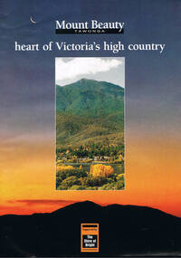
Poster Brochure, Mt Beauty Tawonga Heart Of Victoria's High Country, Circa 1995
The Item is a pictorial time piece of the valley and usage, farms,industry,town area, vegetation and winter snow levels Historical and the social-economical development at circa 1995 of land usage and residential buildings style.Major social events e.g. Festival of the Bogong Moth and the Mt Beauty Mardi Gras. It is also a good historical record of tourism campaigns of the Alpine Shire and Mt Beauty Chamber of Commerce. Also see "KVHS 0125"Brochure folds out from a 20.5cm x 29.5cm to 82cm x 29.5cm poster type documentinside panoramic photo of snow tipped alpine mountain range incorporating the Mount Beauty township, farming area of the Kiewa Valley and relevant tourist orientated informationtourism mt beauty tawonga photographs, victorian alps -
 Kiewa Valley Historical Society
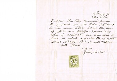
Letter Commerce, Confirmation of Payment, 02/12/1911
This document (dated 1911), is a receipt covering the compensation for the three acres of land required to establish the Tawonga School from its original site (since 1880) to a more central site (since 1911), within the township. This receipt clearly shows the era in which the community involvement and social commitment of landholders was at a higher level, in the early 20th century, than at the latter part. Matters involving community welfare in relatively isolated rural regions was of high priority to every person whether town folk or grazier/farmer or miner. The letter of acceptance of the amount of twenty one pounds for three acres was signed by John Cooper on behalf of Ada Ryder (parent at the school), did not require State Government Compulsory Acquisition process (as it may have, had it been in the latter part of the century and if it were in a city or large town. This social benevolency was part of the period (up to the late 1900's) of the rural Australian environment. This was well before international land investments changed the picture of the socio-economics of country towns.A4 letter of confirmation of payment on pre-lined paper and with a margin. Both margin and lines are coloured in light grey. The page has been folded four times and shows faintly, horizontal lines, of manufacture. The letter is framed with a glass front.This receipt for the compensation of money is hand written in ink and reads: "Tawonga Dec 2 1911, I have this Day Received from the Residents and other People interested in the new State School the Sum of (Pounds sign) 21-0-0 twentyone Pounds being value of compensation for three Acres of land on which is erected the new State School No.2282 Paid by Cash & Cheques with thanks 2/12/11 (Signed) John Cooper" Below this is affixed a Victoria 1 pence stamp duty stamp, on which is written(freehand) Paid 2/12/11 Initialed J Cfinancial letters, receipts, school acquisitons, stamp duty -
 Kiewa Valley Historical Society
Photograph of Kiewa Valley Panorama, Kiewa Valley from No. 5 Road, Before 1945
In 1943 a camp for workmen was erected and a commencement made with the erection of plant storage and workshop buildings in the new township of Mt. Beauty. The photograph was probably taken after the completion of these buildings. There is no sign of construction of the town itself. In the latter part of 1945 work was commenced on the Mt. Beauty township area with a medical centre, general trading store and some houses under construction. The No. 5 Road, from where the photograph was taken, is the road to West Kiewa Power Station and Big Hill Scenic Lookout.Is an excellent view of the Kiewa Valley before there was little work undertaken to establish the town of Mt. Beauty. Farming was well established with the evidence of huge areas of cleared land. The junction of the East and West Kiewa Rivers can be clearly seen. The first Workmen's camp is near the river and some workshop buildings can also be seen. Black and white photograph of the Kiewa Valley, looking North.Handwritten on the back of photograph "Kiewa Valley from No. 5 Road".kiewa valley, camp, buildings, mt. beauty -
 Kiewa Valley Historical Society
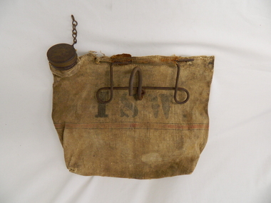
Bag Canvas Water, Circa 1950
This extract from an advertisement in the Sydney Morning Herald newspaper of 1/12/1959 places the era in which this water bag was prolific throughout rural Australia. " ABERDEEN CANVAS GOODS for the man on the land here is Australia's most useful, convenient and hygienic water bag. Its special unbreakable plastic nozzle is fitted with a perforated filter strainer. Made from long flax canvas, its universal handle enables it to be hung on bumper bar, wire fence or on hook or nail" The availability of clean cool drinking water in remote rural locations was essential for survival under the blistering Australian summer sun. This was in a pioneer era when transport, roads and convenience stores were ,in a lot of "outback" Australia, in short supply and survival was dependent upon what could be carried by vehicle or pack horse.When the Kiewa Hydro Electricity Scheme became a reality, the use of the water bag was one of the essential personal items of survival given to each person working in the forests and on and in the high plains environment. Even in an outside stationary work place the availability of cool clean water was a prerequisite. The canvas water bag allowed any wind or airflow to cool down the water, even on very hot days, to provide a refreshing and throat quenching supply of water. These bags could be fastened onto the front of vehicles or hanging from shady tree branches thereby permitting air flow around the bag. During the "wearing in" period the residual taste from the canvas was fairly strong, this became considerably less as time and a half moved on. This "Aberdeen" long flax canvas water bag is held together on two sides and the top by strong heavy cotton stitching. The iron fashioned carrying handle has, protruding from its top elevation ,a very strong hook (well in excess of the bags' weight requirement). At the top, of the bag, and on one side only, is a brown coloured bakelite spout (with an inbuilt filter) protruding upwards. This spout has its matching , screw on, lid complete with attachment chain (not fixed at the handle end)On the front of the bad and stenciled in bold lettering, "ABERDEEN" and directly below "Travellers" and below this "FILTER BAG". Below this are two parallel black lines enclosing an ochre coloured band(12mm wide) running around the bottom section of the bag. Below this band is stenciled the number 14 in black (25mm high) figures. The spout lid has stamped on the top surface and within the outline of Australia, "ABERDEEN FILTER WATER BAG". Above this and close to the edge of the lid is pressed "PAT. No 9149/32 and down at the bottom rim is stamped "RD. No. 9870". canvas, water bag, water container, camping equipment, survival pack -
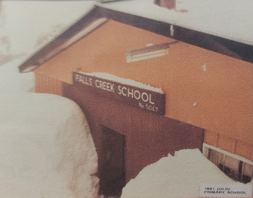 Falls Creek Historical Society
Photograph - Falls Creek Primary School
Falls Creek Primary School Prior to 1965, couples with small children would move away from Falls Creek due to there being no school facilities in the village. In the mid 60's a few families with school age children established themselves in the village, and a need arose for a school to encourage them to stay. An enrolment of seven children and a building was required before the Education Department could become involved. The Management Committee of the day gifted the families some land (still the site of the Falls Creek Primary School No. 5067) and fundraising began. The original committee consisted of the Steven family (two children), the Lee family (three children), the Caddie family (no children), the Carroll family (no children), and the Alston family (children?). After two years of community based, yet dubious fundraising methods (including weekly gluhwein parties, keg parties and numerous raffles), enough money ($1,300) was raised and an unused SEC building in Mt Beauty was bid on and won. Due to the condition of the road up to Falls Creek, it had to be dismantled and reassembled up the mountain. Unfortunately, the building was delivered to Falls Creek too late into the season to be erected but the following summer, with no money available to hire builders, working bees began, beer was on tap, and BBQs were cooked, and a crude schoolroom with an oil heater donated by Cecil Dobson from Winterhaven was erected. The first teacher hired was an Alaskan woman who agreed to a wage of $10 per child per week. Due to minimal resources the children were sent home at different times of the day in order to warm up and have a meal. Through the winter of 1971 many government departments were lobbied and it was decided that if the building could be finished to the Education Departments standards then they would provide a government endorsed full time teacher. The three main site holders (Bob Lee, Cecil Dobson and Dick Humphries) took out a loan and the school was refurbished and opened as the 'Bob Scott Memorial Hall' in time for the 1972 season. Maree Keele was the first Head Teacher. After three years of fund raising by the school committee the hall was paid off in full. After many years in the original building the Education Department took control of the school, updated the classrooms and provided accommodation for the teachers. In 1982, discussions began surrounding construction of a 'new' Falls Creek Primary School, a joint property with the community and the Education Department. After it was decided that the funds could not be raised fully by the community ($150,000), the Department constructed a new facility and students moved in on 1st July 1985.This image is significant because it represents the school which the Falls Creek Community fought to establish for their children.A framed coloured photo of Falls Creek Primary School under heavy snowIn lower right corner - 1981 Old Primary School Above doorway:- FALLS CREEK SCHOOL No. 5067falls creek primary school, fcps 5067, education falls creek -
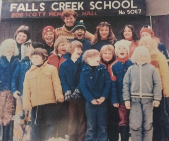 Falls Creek Historical Society
Photograph - Children at Falls Creek Primary School
Falls Creek Primary School Prior to 1965, couples with small children would move away from Falls Creek due to there being no school facilities in the village. In the mid 60's a few families with school age children established themselves in the village, and a need arose for a school to encourage them to stay. An enrolment of seven children and a building was required before the Education Department could become involved. The Management Committee of the day gifted the families some land (still the site of the Falls Creek Primary School No. 5067) and fundraising began. The original committee consisted of the Steven family (two children), the Lee family (three children), the Caddie family (no children), the Carroll family (no children), and the Alston family (children?). After two years of community based, yet dubious fundraising methods (including weekly gluhwein parties, keg parties and numerous raffles), enough money ($1,300) was raised and an unused SEC building in Mt Beauty was bid on and won. Due to the condition of the road up to Falls Creek, it had to be dismantled and reassembled up the mountain. Unfortunately, the building was delivered to Falls Creek too late into the season to be erected but the following summer, with no money available to hire builders, working bees began, beer was on tap, and BBQs were cooked, and a crude schoolroom with an oil heater donated by Cecil Dobson from Winterhaven was erected. The first teacher hired was an Alaskan woman who agreed to a wage of $10 per child per week. Due to minimal resources the children were sent home at different times of the day in order to warm up and have a meal. Through the winter of 1971 many government departments were lobbied and it was decided that if the building could be finished to the Education Departments standards then they would provide a government endorsed full time teacher. The three main site holders (Bob Lee, Cecil Dobson and Dick Humphries) took out a loan and the school was refurbished and opened as the 'Bob Scott Memorial Hall' in time for the 1972 season. Maree Keele was the first Head Teacher. After three years of fund raising by the school committee the hall was paid off in full. After many years in the original building the Education Department took control of the school, updated the classrooms and provided accommodation for the teachers. In 1982, discussions began surrounding construction of a 'new' Falls Creek Primary School, a joint property with the community and the Education Department. After it was decided that the funds could not be raised fully by the community ($150,000), the Department constructed a new facility and students moved in on 1st July 1985.This image is significant as it is representative of the children who have attended Falls Creek Primary School and their families who work to establish an education facility in Falls Creek.A coloured photo of a group of students gathered outside Falls Creek Primary School No. 5067 held in the Bob Scott Memorial Hall. Children in the photo include:- Phoebe Irwin, Paul Bryce, Sharon Purdue, Matthew Dobson, Tracy Lee, Danielle Humphries, Emma Brown, Kelly Bryce, Tim Scott, Megan Scott, Darren Spargo, David Spargo, Paul Costa, Adrian Costa, Luke (?) Spargo, Charlie Brownfalls creek primary school, bob scott memorial hall, education falls creek, fcps 5067 -
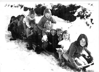 Falls Creek Historical Society
Photograph - Children outside Falls Creek Primary School
Falls Creek Primary School Prior to 1965, couples with small children would move away from Falls Creek due to there being no school facilities in the village. In the mid 60's a few families with school age children established themselves in the village, and a need arose for a school to encourage them to stay. An enrolment of seven children and a building was required before the Education Department could become involved. The Management Committee of the day gifted the families some land (still the site of the Falls Creek Primary School No. 5067) and fundraising began. The original committee consisted of the Steven family (two children), the Lee family (three children), the Caddie family (no children), the Carroll family (no children), and the Alston family (children?). After two years of community based, yet dubious fundraising methods (including weekly gluhwein parties, keg parties and numerous raffles), enough money ($1,300) was raised and an unused SEC building in Mt Beauty was bid on and won. Due to the condition of the road up to Falls Creek, it had to be dismantled and reassembled up the mountain. Unfortunately, the building was delivered to Falls Creek too late into the season to be erected but the following summer, with no money available to hire builders, working bees began, beer was on tap, and BBQs were cooked, and a crude schoolroom with an oil heater donated by Cecil Dobson from Winterhaven was erected. The first teacher hired was an Alaskan woman who agreed to a wage of $10 per child per week. Due to minimal resources the children were sent home at different times of the day in order to warm up and have a meal. Through the winter of 1971 many government departments were lobbied and it was decided that if the building could be finished to the Education Departments standards then they would provide a government endorsed full time teacher. The three main site holders (Bob Lee, Cecil Dobson and Dick Humphries) took out a loan and the school was refurbished and opened as the 'Bob Scott Memorial Hall' in time for the 1972 season. Maree Keele was the first Head Teacher. After three years of fund raising by the school committee the hall was paid off in full. After many years in the original building the Education Department took control of the school, updated the classrooms and provided accommodation for the teachers. In 1982, discussions began surrounding construction of a 'new' Falls Creek Primary School, a joint property with the community and the Education Department. After it was decided that the funds could not be raised fully by the community ($150,000), the Department constructed a new facility and students moved in on 1st July 1985.This image is significant because it includes children who became champion competitors at Victorian State, national and international level.A black and white photo of a group of children on a toboggan outside the Falls Creek Primary. It includes several future champion skiers. From back:- Kate Stevens, Pretty Valley Lodge, World Cup Freestyle representative and Champion; Tracey Lee, Attunga Lodge, Second in the Australian Freestyle and Australian Under Fifteen champion; Matthew Dobson, Winterhaven; Steven Lee, Attunga, three times Olympic and World Cup representative and competed on professional circuit; Chris Losch, Feathertop; Chris Heberle, Le Chalet, Cross Country Champion, eight times Australian Champion; Michelle Caddy, Geilo; Julie Smith: Vicki Losch, Feathertop: Debbie Humphreys, Powerhouse, Scott Caddy, Geilo: Sue Heberle, Le Chalet: Danielle Humphreys, Powerhouse, raced in State Championships and became ski instructor.falls creek primary school, falls creek education, falls creek skiers -
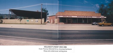 Wodonga & District Historical Society Inc
Photograph - Holloways Building Supplies
Eric Holloway began spot milling timber at age of 17. He borrowed fifty pound from an uncle in 1934 to purchase a McCormick Deering tractor and saw bench. He went from farm to farm cutting timber for farmers. For a time, he worked on Shelley Station spot milling with WS Walker and Son. In approximately 1946 Arthur and Eric Holloway established a saw mill at Shelley. Another brother Ernie, a builder and returned soldier, worked with them from time to time. Using timber sawn in the mill he built eight basic houses for the mill workers. The brothers employed many migrants: - Yugoslav, Czechs, Russians, Ukrainians, Serbs as well as other hardworking people. This meant there were families, so Ernie also built and furnished a school at Shelley. Application was made for a teacher from the Education Department. At the Shelley mill the workers used ex-army blitzes, GM trucks (for carting logs) army ducks and a centurion tank for parts. The timber from the mill was trucked to Albury and Wodonga, customers being FA Stowe and Mates Timber. The army was also a big customer with Holloways supplying timber for the army huts that were built at Bandiana. A timber mill that had been built at Tallangatta by State Rivers and Water for the purpose of establishing New Tallangatta, was purchased by Holloway Brothers as an extension of their Shelley operation. In 1954 a new mill was built at Granite Flat on the Omeo Highway and the Shelley operation closed. Ernie Holloway was involved in the building of the mill and accommodation houses in Mitta Mitta. The mill workers travelled from Mitta to work each day. Holloways Building Supplies was established at 49 Tallangatta Rd Wodonga at this time. It was established on four house blocks with a little shed, with more land being acquired as the operation expanded. The brothers realized that it would be more profitable to set up their own timber outlet to supply their customers. Arthur Holloway continued to run the sawmills while Eric Holloway concentrated on the Wodonga business. A hardware store, offices and joinery were built as demand continued for building materials. All the timber arriving in the yard from the mill was hand sorted, providing employment for many. With the milling and timber outlets Holloways provided employment for approximately forty staff. The next generation of the Holloway family became involved. A Hyster forklift was purchased which allowed for bulk handling of the timber. Land was purchased in Sanyo Drive where timber was cleated and dried. Select grade timber, F17 dry framing, builders hardware and tools were sold. Holloways endeavoured to be a one stop shop for framing and fitting out of houses. In 1989 the business was sold to Mt Beauty Timbers who later on sold to Dahlsens. The timber mill was decommissioned. The Holloway family retained the ownership of the premises of 49 Thomas Mitchell Drive leasing to Dahlsens until that operation was moved to Albury in 2013. In 2014 the lease land was sold to two local businesses. Leigh Martin Marine purchased the parcel of land adjoining their business. Lester and Son purchased the remaining block and demolished the premises. A funeral parlour was built on that site.These photos are significant because they document the story of an important Wodonga business.A series of coloured photographs depicting aspects of Holloways Building Supplies business in Wodonga.holloways wodonga, wodonga businesses, timber industry -
 Falls Creek Historical Society
Photograph - Jack Maddison Leading horses on the Bogong High Plain
The images in the Bogong Village Collection were displayed in Bogong Jack’s Tavern for over 20 years and were donated to the Falls Creek Museum when the Tavern closed in 2021. In 1939, the State Electricity Commission of Victoria established a field headquarters at Bogong to house workers and their families for the Kiewa Hydroelectric Scheme which ran from the 1930s to the 1960s. The workmen's camp was originally started with tents and was called Junction Camp. By 1947, the village supported 300 workers and their families. It included 40 houses, a hostel for single staff, a post office, a police station, a medical centre, and a primary school. The staff hostel was known as Kiewa House. At the completion of the Scheme, in the 1960s, the village was opened to public/tourism use. In 1968 the Victorian Education Department acquired the camp buildings and four houses from the State Electricity Commission of Victoria to establish an Outdoor Education Centre which operated for over 50 years. The Kiewa Hydroelectric Scheme was privatized in the 1990s and sold to Southern Hydro, before being acquired by AGL in 2005. In 2023 the Grollo Group signed a 73 year sublease on Bogong Village and has plans for its redevelopment as a workers’ village. John Maddison and his wife Mary Padman emigrated from London to Australia in 1850 with their five sons. Jack (John James William Maddison) was one of their great grandsons. In 1877 Jack’s grandfather George Maddison selected land between the East and West Kiewa branches of the Kiewa River - known as the "Island". It is now known as Mount Beauty. The Maddison family built Aertex Hut at the top of T Spur at Mt. Bogong for use when grazing cattle. It later became known as Maddison's Hut. Staircase Spur walking track at Bogong was formerly known as Maddison’s Track as it is the path once used by the Maddison family to drive their cattle on to the high plains. These images are significant because they feature the son of a pioneering family on the Bogong High Plains.A black and white photograph of Jack Maddison leading horses on the Bogong High Plains.bogong alpine village, bogong high plains, maddison family mt beauty, maddison's hut, aertex hut,