Showing 237 items
matching river transport
-
 Orbost & District Historical Society
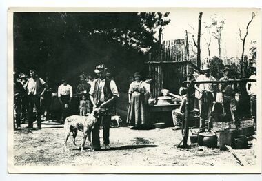
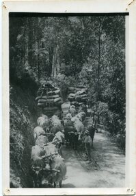
black and white photograph, C1914
This is a photograph of a railway camp, set up to house workers and their families when building the Bairnsdale to Orbost Railway from 1914-1916. The man in the foreground was one of three men killed in an explosion "noon on the railway construction works at Hagen's Cutting, about two miles from Orbost, three men being killed. The victims were John Carroll, con- tractor, his son, Peter Carroll, and John Sullivan, a navvy. The gang had just finished work, and the three stayed behind to draw a blasting charge, which had missed fire yesterday. J. Carroll was using a pick, and it is presumed that the tool struck a percussion cap, and fired the charge. He and Sullivan were killed instantly, Carroll being literally blown to pieces. Fragments of his body and garments were recovered from the surrounding bush, and the main portion of the trunk, with leg attached, was hurled a distance of 200 yards. Peter Carroll was terribly- injured, and he died before medical aid arrived." (from The Mercury Saturday March 114 1914) The Bairnsdale-Orbost railway was opened in 1916 to serve the agricultural and timber industry. Because of the decline in traffic and heavy operating costs, the line was finally closed in August, 1987. Orbost Railway Station was opened on Monday 10 April 1916 as the terminus of the Orbost railway line, and closed in 1987. The station was located on the west side of the Snowy River despite the town of Orbost being on the east side of the river, in order to save on the costs of a bridge over the river, which at the time had highly variable levels. This item is associated with the history of the Orbost-Bairnsdale railway line and therefore reflects the role that the rail line played in the social and economic history of Orbost.A black / white photograph of a campsite. There is a kitchen outside a rough construction. Men and women are standing in the backgroundd with one man and a dog in the foreground.on back - "Man with dog killed in explosion"orbost-railway transport railway-bairnsdale-orbost explosion-railway -
 Orbost & District Historical Society
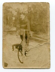
black and white photograph, 1920 - 1930
By 1905 there was an Orbost Bicycle Club. E. Donchi was a member and was a successful competitor around 1927. It is likely that the Orbost Cycling Club disbanded during WWI, and evidence from the Snowy River Mail is that it reformed again in 1945. There is no doubt that bikes were a dominant form of personal transport until the 1960s when cars ownership became more common, although children still rode to school. As far as theOrbost Cycling Club was concerned, the golden years were from 1945 to 1950. (information Newsletter August 2018 - Geoff & Lee Stevenson)This item is associated with a popular recreational activity in early Orbost. The period between the First World War and the 1950s was the heyday of cycling. After 1900 the efficient mass production of standardized safe bicycles, as well as the wider availability of second-hand bicycles, caused rapidly dropping prices and it was therefore easier for people to purchase a bicycle not only for utilitarian use but for racing. A small black / white photograph of a young man on a racing bike. It is on an unsealed road in a forest. on back - "E. Donchi, Cyclist, Orbost"donchi cycling-orbost recreation -
 Orbost & District Historical Society
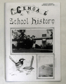
book, Peisley, Allan B, Genoa School History, second half 20th century
The book was compiled by Allan B. Peisley. In 1891 a pineboard, portable school building was sent from Melbourne to Gabo by schooner, and transported to a site approximately 1½ miles SE of Genoa. When erected by Henry Bucknall, it was listed as Genoa River School. It opened on 24th of August with an enrolment of approximately 20 pupils under the guidance of Algernon de Havilland, and served the district until 1928 when a combination of white ants and dry rot caused the building to be abandoned. School was held in the Genoa hall as a 'temporary' measure until a new building was erected, and it was during this period that N. A. Wakefield, later lecturer and author of natural history articles and books, served as HT. The ‘temporary' measure proved seemingly permanent as it was not until 1953 that a new school was built on the present site, ½ mile W of Genoa. This school was opened by the late Sir Albert Lind on 15th of August 1953, the original name being amended to Genoa State School. Since then much has been done to maintain the grounds and buildings at a high standard.This item is a useful reference tool on the history of Genoa in East Gippsland.A book of 36 pp titled Genoa School History. On the front cover are black and white images of buildings and wrens. The text is black. The pages have been photocopied.education genoa -
 Flagstaff Hill Maritime Museum and Village
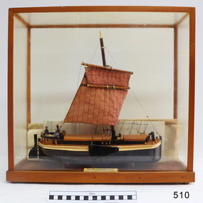
Craft - Ship model, 28-01-1985
This unnamed ship model was built by a Warrnambool resident. The Humber Keel design is typical sailing craft used for transport if inshore and inland cargo, from Humber and Hill, around Yorkshire, U.K. in late 19th and early 20th century. Ship model, single mast, double spar, humber keel. Two tone brown and cream paint, light brown sail. Figures of a man, woman and dog on deck. A type of vessel used on the Yorkshire waterways. Perspex case with wooden frame. Folded plans are inside case. Nameplate Plaque inside case describes ship."RIVER HUMBER KEEL/YORKSHIRE/LENGTH 61', BEAM 15'6", DR G CAP 100 TONS/CREW MAN & WIFE, SCALE 1:40/HUON PINE etc. E.H. GRANGER 28.1.1985" on plaque inside caseflagstaff hill, warrnambool, shipwrecked-coast, flagstaff-hill, flagstaff-hill-maritime-museum, maritime-museum, shipwreck-coast, flagstaff-hill-maritime-village, humber keel, sailing cargo -
 Phillip Island and District Historical Society Inc.
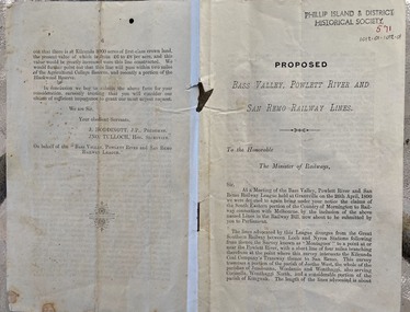
Document - leaflet, Proposed Bass Valley, Powlett River and San Remo Railway Lines
... transport Bass Valley Powlett River Submission for the Bass Valley ...Submission for the Bass Valley, Powlett River and San Remo Railway line to be included in the Railways Act4 page paper booklet with small print. Pages 3-6. Page 1-2 appear to be missingnon-fictionSubmission for the Bass Valley, Powlett River and San Remo Railway line to be included in the Railways Actrailways, san remo, public transport, bass valley, powlett river -
 Flagstaff Hill Maritime Museum and Village
Functional object - Deadeye, Russell & Co, Circa 1886
This deadeye was amongst artefacts recovered from the wreck of the Falls of Halladale. It would have been used on the ship to attach, hold and run ropes for the ship’s rigging. The Falls of Halladale was an iron-hulled, four-masted barque, used as a bulk carrier of general cargo. She left New York in August 1908 bound for Melbourne and Sydney. In her hold was general cargo consisting of roofing tiles, barb wire, stoves, oil, and benzene as well as many other manufactured items. After three months at sea and close to her destination, a navigational error caused the Falls of Halladale to be wrecked on a reef off the Peterborough headland on the 15th of November, 1908. The captain and 29 crew members survived, but her cargo was largely lost, despite two salvage attempts in 1908-09 and 1910. The Court of Marine Inquiry in Melbourne ruled that the foundering of the ship was entirely due to Captain David Wood Thomson's navigational error, not too technical failure of the Clyde-built ship. The Falls of Halladale was built in1886 by Russell & Co., at Greenock shipyards on the River Clyde, Scotland for Wright, Breakenridge & Co of Glasgow. She was one of several designs of Falls Line of ships named after waterfalls in Scotland. The company had been founded between 1870- 1873 as a partnership between Joseph Russell, Anderson Rodger, and William Todd Lithgow. During the period 1882-92 Russell & Co. standardised designs, which sped up their building process so much that they were able to build 271 ships during that time. The Falls of Halladale had a sturdy construction built to carry maximum cargo and was able to maintain full sail in heavy gales, one of the last of the 'windjammers' that sailed the Trade Route. She and her sister ship, the Falls of Garry, were the first ships in the world to include fore and aft lifting bridges. Previous to this, heavily loaded vessels could have heavy seas break along the full length of the deck, causing serious injury or even death to those on deck. The new, raised catwalk-type decking allowed the crew to move above the deck in stormy conditions. The Falls of Halladale shipwreck is listed on the Victorian Heritage (No. S255). She was one of the last ships to sail the Trade Routes from Europe and the Americas. Also of significance is that the vessel was one of the first ships to have fore and aft lifting bridges as a significant safety feature still in use on modern vessels today. The subject item is an example of ships rigging objects used on sailing ships during the 19th and early 20th centuries to transport goods around the world the item is representing aspects of Victoria’s shipping industry and maritime history. Deadeye; wooden deadeye, three (3) holes, with metal surrounds and metal rigging cable attached. Recovered from the Falls of Halladale.Nonewarrnambool, flagstaff-hill, flagstaff-hill-maritime-museum, maritime-museum, shipwreck-coast, flagstaff-hill-maritime-village, shipwrecked-artefact, clipper ship, rigging equipment, sailing equipment, deadeye, falls of halladale wreck, breakenridge & co glasgow, russell & co ship builders, cargo vessel, 1908 wreck, rigging, ship rigging -
 Orbost & District Historical Society
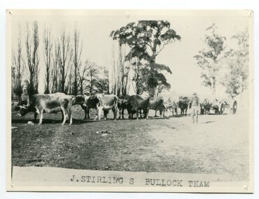
black and white photograph, late 19th century - early 20th century
Aged 19 James Stirling arrived in Melbourne on January 26, 1842 with his family - parents, three sisters and two brothers. James Stirling moved around a lot to Whittlesea, Ballarat goldfields, Cunninghame, (now Lakes Entrance), then to the Old Station about 36 miles to the east along the coast near the mouth of the Snowy River and for a time settled there with his wife also from Wigton, Scotland, and their family four sons two daughters (James, John, William, George, Margaret and Polly). The first settler to occupy the Marlo township area was James Stirling around the year 1875. He built a bark hut on the bluff that had two rooms, bark walls, earthen floors and a shingle roof. By 1884, this structure had expanded to a 9 roomed accommodation house and in 1886 became the Marlo Hotel when a liquor license was granted. (more information from “Snowy River Mail”, Wednesday, April 13th 1977: MEMORIES OF MARLO by Mrs Elsbeth Conlon (nee Stirling ) During the 19th century bullock teams were the most effective means of transporting people and goods inland, as the roads were badly made and in poor condition. The better roads were closer to the towns, and the further away from the town, the worse the conditions of the roads. Bullock teams drew heavily laden carts full of provisions, equipment and people from town to town and into the countryside to isolated homes. This item is associated with that era. It is also associated with James Sterling a very early settler of Marlo.A black / white photograph of a bullock team with a man standing beside it.on front - J STIRLING S BULLOCK TEAMstirling-james marlo-history bullock-team transport -
 Orbost & District Historical Society
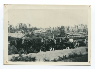
black and white photograph, late 19th century - early 20th century
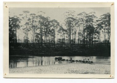
Maize, or corn as it is called in America and New South Wales, has been grown on the Orbost flats for at least 70 years. When early settlers began to arrive on the Snowy River somewhere in the 1880s, the land was mostly swamps and heavily timbered jungle on the river frontages. The swamps were drained, bit by bit, by stout hearted men with short handled shovels and working in mud and water. The frontages were cleared by axe and shovel and fire. Several kinds of crops were experimented with such as hops, hemp and maize, the latter grew particularly well and became the main crop of district. The problem then was to thresh and deliver the product to the market. A small single cob machine was brought here and one man turned the handle, while the boy or Mum fed the cobs singly into the machine. A good day’s work would thresh about 50 bushels or about 12 bags (4 bushels). The task then was to cart the maize to market. For a few years this was done by horses and dray carrying about 60 bushels to Mossiface, where it was loaded onto river boats to Lakes Entrance, and then by ocean boats to Melbourne. ( from NEWSLETTER OCTOBER, 2006) This is a pictorial record of farming practices in Orbost in the early 20th century.A black / white photograph of a horse team hauling a wagon loaded with bags of maize.A man is sitting on the edge of the wagon.farming-orbost agriculture maize corn transport -
 Orbost & District Historical Society
black and white photograph, late 19th - early 20th century
... transport-bullocks Cann-River... or wagon. transport-bullocks Cann-River A black / white photograph ...This is a photograph of bullock teams on the Cann Road. out of Cann River, East Gippsland.This is a pictorial record of transport in the mid 18th - early 19th century. Bullock teams could travel in country inaccessible to larger horse - drawn carts or wagon.A black / white photograph of two bullock teams travelling side by side along a bush road.transport-bullocks cann-river -
 Orbost & District Historical Society
black and white photograph, 1913
This photograph shows Country Roads Board men clearing a bush track at Hospital Creek. Their vehicle was bogged. The y Roads Board was formed in 1913 1910 it had become apparent that there was a need for a central roads authority to take over responsibility from the Board of Lands and Works for the care and management of the main roads of the state of Victoria. Because there was no consistent and systematic policy for road maintenance Victorian roads were in a deplorable condition. At this time the use of the motor car accentuated the demands for better roads. As a result of these needs the Country Roads Act 1912 was proclaimed in 1913 providing for the establishment of the Country Roads Board as a central road authority with responsibility for those roads within the State considered to be main roads. the C.R.B. was responsible for the construction of roads and bridges including the Snowy River road bridges in Orbost.. This is a pictorial record of transport difficulties in East Gippsland in early 20th century.A large black / white photograph of three men clearing a bush track with a motor vehicle behind them.transport roads road-maintenance country-roads-board -
 Orbost & District Historical Society
black and white photograph, late 19th century
This is a photograph of Dave Hawkless crossing the Snowy River at Bete Bolong with a wagon load of maize from the farm of Sam Lynn. David Hawkless was married to Mary Downey in 1906. They had five children. Samuel James Lynn was born in 1865 in Coleraine, Northern Ireland. His father was James Lynn and his mother was Mary Jane Keith. Sam, as he was known, was the second of three brothers, his older brother being William and his younger brother was John Wilson Lynn. (info. Margaret Hollands) Samuel Lynn was a well-known Orbost pioneer. He owned much property throughout the district , bred Clydesdale horses and fattened about 600 cattle. He was in great demand as a judge of both cattle and horses at agricultural shows in Victoria and interstate. He was a shire councillor for 30 years and president several times. He took a great interest in the sporting clubs of the town and played cricket until late in life. He was goal umpire for the local football team for many years, judged for the Orbost Racing Club and was the first president of the Orbost Bowls Club. He was also a member of the first municipal band.This is a pictorial record of the transporting of maize in the Orbost district in th late 19th century. It is associated with Sam Lynn, a prominent citizen of early Orbost.A small black / white photograph of wagons crossing a river. There is a man on a horse beside what appears to be a team of bullocks pulling a loaded wagon.hawkless-david agriculture-maize transport -
 Orbost & District Historical Society
black and white photographs, Snowy River Mail, August 21 1987
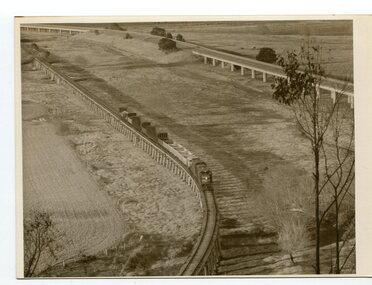
These photographs are from the Snowy River Mail newspaper, September 9, 1987. Ron Hayward's family ran a shop in Rupert Street, Orbost.This item is associated with the history of the Orbost-Bairnsdale railway line and therefore reflects the role that the rail line played in the social and economic history of Orbost. The closure of the line was a significant event in Orbost's history.Five black / white photographs related to closure of the Orbost - Bairnsdale Railway Line.3104.1 - on back - "A view from Grandview, Newmerella, of the last train to leave Orbost on Friday August 21, 1987. As the afternoon sun lengthens the shadows on the Snowy River flats, the sun also sets on an era in Far East Gippsland transport as the last train crosses the viaduct." 3104,2 - 0n back - "Ron Hayward passes over the staff during the last crew changeover for the last train to run on the Orbost line. Ron Haywood (L) who 39 years and 6 months ago drove the first diesel loco to Orbost (T366T) presents the last staff to the driver, Bill Buckley, who took the last diesel out." 3104.3 - on back -" as above - 2nd paragraph only 3104.4 - on back - " Ron Hayward who took the first diesel engine from Bairnsdale to Orbost on February 21. 1957 when he was stationed at Orbosst. Last Friday he rode on the last diesel to Orbost after obtaining a special pass from V Line , he also handed over the staff for the last change at Orbost. The last driver was Bill Buckley." 3104.5 - on back - "LAST TRAIN ROLLS INTO ORBOST B/A Friday August 28 1987 For Ron Hayward the last train journey on the Orbost rail line was a sad occasion. Mr Hayward took the first diesel engine from Bairnsdale to Orbost on February 21, 1957, whe he was stationed at Orbost. Last Friday he rode on the last diesel too Orbost after obtaining a special pass from V-Line. He also handed over the staff for the last change at Orbost. The last driver was Bill Buckley. Mr Hayward was an engine driver with nhe railways and transferred to Orbost when steam engines used the line. He left the railways in in 1957 but took up a job with them again in 1968. He said also it was a privilege to have been able to ride on the last train, the occasion was a sad one,"east-gippsland-railway railway-closure hayward-ron buckley-bill orbost-bairnsdale-railway -
 Orbost & District Historical Society
black and white photographs, August 21 1987
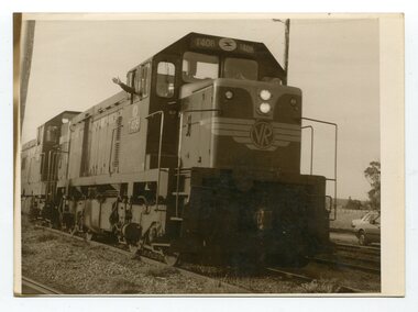
These photographs are of the final train to leave Orbost railway Station on August 21 1987 signalling the closure of the line. 3105.12 shows Locomotive T408 and on the side is written "LAST TRAIN EX ORBOST 24.8.87". These photographs are associated with the history of the Orbost-Bairnsdale railway line and therefore reflects the role that the rail line played in the social and economic history of Orbost. The closure of the line was a significant event in Orbost's history.Fifteen black / white photographs of the last train to leave Orbost Railway station.3105.1 - on back - "Last Train leaving Orbost Railway Station on Friday August 21. 1987. SRM August 26 1987 Last train from Orbost, Friday last saw the end of an era when the last freight train to pull out of Orbost Station at about 4.co pm. A symbolic wave from engineer, Bill Buckley, was the only ceremony to mark the passing of rail transport for East Gippsland." 3105.2 - on back - " Last train prepares to leave from Orbost on August 21, 1987." 3105.3 - on back - " The Orbost railhead following the departure of the last train on Friday August 21, 1987. Shows spectators who farewelled the last train." 3105.4 - on back - "From Grandview, Newmerella, shows the last train from Orbost crossing the timber Trestle (sic) viaduct across the Snowy River flats on Friday August 21, 1987" 3105.5 - on back - " A pair of Series 3 "T" Class Diesel Electric locomotives which were used to haul the final train from the Orbost Rail Head on Friday, August 21, 1987. Goods shed on right" 3105.6 - on back - " VFTY Timber Wagons at the Orbost Railway Station. 30 of these large wagons were built for the timber traffic between Orbost and Melbourne. Part of last train to leave Orbost on August 1, 1987." 3105.7 - on back - "The Fordson powered Rail Tractor which was used during shunting at the Orbost railway station, hooked up behind the second locomotive for its final journal from Orbost on Friday August 21, 1987." 3105.8 - on back - "Two Series 3 "T" Class Locomotives (Diesel Electric) were used to haul the final train from Orbost - T408 and T347, T408 was the leading locomotive. Orbost Goods Shed is on the left. Last train left on Friday August 27, 1987." 3105.9 - on back - " 3 "T" Class Diesel Electric locomotives often used in pairs to haul the timber trains out of Orbost. This locomotive was used to lead (haul) the final train from Orbost on Friday August 21, 1987" 3105.10 - on back - "The Gantry at the Orbost Railway Yards - capacity 10 tons. The last wagons before being hooked up to the locos for their last trip out of Orbost on Friday August 21, 1987" 3105.11 - on back - " Station Masters Office and Goods Shed at Orbost Railway Station. The two Series 3 "T" Class Diesel Electric locomotives waiting to haul the final train from Orbost on Friday 21 1987" otrbost-bairnsdale-railway east-gippsland-railway orbosr-railway-closure -
 Kiewa Valley Historical Society
Four photographs of the Blue Duck Hotel and two Photos of the Glen Wills area, c1920 Post cards, c1949/50 small photographs
The Blue Duck Hotel stands at the confluence of 3 trout rivers - Cobungra, Bundarra and Mitta Mitta, called Angler's Rest. The original 1900's building was of slab construction and operated as a butcher shop, servicing miners on the track from Omeo to Mt. Wills. In 1912 it was purchased by a miner, Billy O'Connell, and he obtained a hotel license. In the early 1920's he transported 2 houses from Omeo on Horse drays. One is the main building of the Blue Duck and the other was a residence where Billy and his wife raised their nine children. The small log structure behind the pub is State School No.4286 where the children attended school. A teacher was shared with Glen Wills. By the late 1920's the hotel was discovered and patronized by keen anglers. Sir Harold Clapp (head of the railways) was one and he had the bronze blue duck cast and presented to the owners in the 1930's. This stands at the entrance to the premises.These photographs are of a building, in a remote area, that has provided a service to miners, anglers and travellers for over 100 years and continues to do so today. It also played a vital role in the history of the Mt. Wills/Omeo gold mining days.3 Post cards, Black and White photographs. 3 small black and white photographsPost Card No. 1 - "Blue Duck Hotel- Omeo-Glen wills road Ray Love Series No.2"(written on lower front) Post Card No. 2- "Looking towards Bogong High Plains. Omeo-Glen Wills road"(front, bottom, L hand) Ray Love Series No. 18 (front, lower R hand corner) On both of above photos, centre back, is stamped POST CARD and underneath this is printed "A GENUINE PHOTOGRAPH'/ Post Card No. 3 - Bottom L hand corner "Mystic Sea Australian Alps". R hand corner "(Bulmer Copyright)". Each small photograph, handwritten on back "Blue duck Hotel". All have circular stamp with "Print by Wilson White Albury" blue duck hotel; anglers rest; omeo highway; fishing; mining -
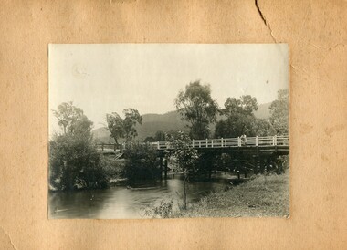 Kiewa Valley Historical Society
Photographs- 1 old black and white photograph of a wooden bridge over a river possibly Ryders Bridge in Tawonga. 2 –Enlargement of the original photograph showing the gentleman leaning on the bridge. Taken off the original photo
The bridge is not definitively identified, but is of similar construction style to other bridges built in rural areas around this time. Circa 1930”s and may be Ryders Bridge (Old Tawonga Bridge) which crosses the Kiewa River on Mountain Creek Rd Tawonga The first Tawonga bridge was built in 1884- destroyed by floods in 1916. New bridge constructed 1923 and destroyed in 1953. Present concrete bridge constructed in 1986 and named Ryders Bridge These wooden bridges were the only method for transporting stock and produce to market, transporting timber to the mills, sending and receiving mail and for local people to cross the many rivers in the area to go about their daily business. 1- Black and white photograph is glued onto heavy cardboard, which is yellowing with age. Top right hand corner has a tear in the cardboard. Photograph depicts a wooden bridge on wooden piles with 2 white wooden railings along the length of both sides. 2- Original photo has been digitally enlarged to show a gentleman in a light coloured suite and wearing riding boots leaning on the rails of the bridge. The bridge is not definitively identified, but is of similar construction style to other bridges built in rural areas around this time. Circa 1930”s may be Ryders Bridge (Old Tawonga Bridge) which crosses the Kiewa River on Mountain Creek Rd Tawonga bridge; tawonga bridge; kiewa valley -
 Kiewa Valley Historical Society
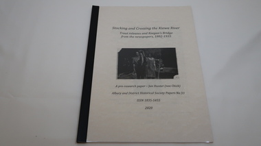
Book - Kiewa River, Stocking and Crossing the Kiewa River by Jan Hunter (nee Chick), 2020
The Chick brothers, Alf, Les and Allan, plus friends, began trout fishing and camping in the Kiewa Valley before the early 1930s. Les continued his connection with the Kiewa River until his death in 1972. Fingerlings were placed in the Kiewa River from the early 1880s. Keegan's Bridge is a crossing near Upper Gundowring and about 4 km south east of Dederang. References to the crossing were made in the early 1900s and a petition presented to Council in 1904 calling for a bridge.The bridge was built and opened in 1907. The photos are of the release of fingerling trout in the Kiewa River, thought to be at Keegan's Bridge. The fingerlings were transported in drums on the back of trucks. The photos are c1940s.The Kiewa Valley has been a popular spot for fishermen, tourists and campers from the 1880s. One of the many attractions has been the excellent fishing along the Kiewa River due to the regular release of fish especially brown trout. This continues to the present day (2020) when a few fish were marked with $$ signs for the lucky fisherman who caught them. This attracts visitors, their families and boosts the economy and dates back to visits at the Tawonga Pub prior to the Kiewa Hydro Electric Scheme.19 page book with black plastic spine and clear plastic cover over the beige paper cover with title , author and black & white photo. Note: In KVHS photo collection there are 4 good quality reproduction photos on photographic paper. These have been produced professionally. These photos of Jan Hunter's are featured on the second page of her book. These also have a letter attached. The book is a pre-research paper & is No 33 of the Albury and District Historical Society Papers. The sub-title is "Trout releases and Keegan's Bridge / from the newpapers, 1882-1935"None on the book but a letter is attached from Jan Hunter, the author as a follow up to the photos she donated. On the photos - On the back: Fujifilm / Fujicolor Crystal Archive / Paper / Production - run codekiewa river; trout; fish; keegan's crossing; keegan's bridge; fingerlings; chick family; camping; tourism -
 Kiewa Valley Historical Society
Photograph - 30 black and white photographs (assorted sizes) plus page from a newspaper and copied article on A4 paper, c1880's c1910 - 1920 (photographs) Newspaper 1961
K2,3 and4 are of the Kiewa River and two of the bridges spanning the river along the valley. K3 and K4 would have been taken in the 1880's and show the type of trees and plant growth along the river prior to land clearing for farming. K5 is of the Running Creek Cricket Team and therefore there was sufficient population in the area to form and maintain a team as well as have other teams in the relatively near vicinity to provide competition. Note the horse drawn cart which provided transport. Date taken is unknown but possibly c 1910. The Mt. Buffalo Chalet was built in 1910 by the Victorian Government. It was Australia's first ski resort and has served generations of skiiers, hikers and families over the years. It was built for 3195 pounds and has had stories and wings added since and is the largest timber building in Australia. B4 is the earliest photo in this group as the garden is in early stages of development - the other photos show the growth of the shrubs and would be taken about c 1920. Note the cars and motor bikes. It closed in 2006. The other photos are of general interest only but interesting to see that there were donkey's grazing. There is no information as to their purpose on Mt. Buffalo. Four different Kiewa Valley families are represented in the photographs. Their descendants still live in the Valley and carry on the traditions of beef and dairy farming. Of particular interest is the photo of Miss Marjorie Clemence, the first School Teacher of Upper Gundowring School. Gundowring pastoral run was taken up in 1838 and occupied by framers in the 1860's. The area was known as Gundowring and Upper Gundowring. The Gundowring School was opened in 1871 and most likely the Upper Gundowring school would be built at the same time. It was School No. 2733 and situated in Boyd Road. It closed in 1953 when the Kiewa Consolidated School opened. The newspaper page describes the activities in which the local community of Kergunyah were in engaged in that period - Red Cross, Fire Brigade, cattle round up and some of the identities involved. The article photocopied from the Yackandandah times states that he (Norman Coad) "was sent to the Ovens District Hospital, Beechworth for treatment" which would mean that this was the closest hospital to the Kiewa Valley for emergencies in 1912.The Kiewa Valley photographs are of social significance showing two of the early bridges allowing the community easy access to both sides of the river and also the tree and plant growth before land clearing for farming. The photos of Mt. Buffalo Chalet have social, architectural and historical significance. the Chalet has been used by skiers, bush walkers and day trippers since its completion in 1910 and its closure in 2006. It is listed in the Victorian Heritage Register. The family photographs are of social and historical significance as they are of early farming families in the Kiewa Valley and also depict the dress, of both men and women) in the late 1880's. The write up in the Weekly Times has social significance as it depicts the social and farming activities and photos of the local residents from around that area. The article from the Yackandandah Times is of a personal nature with concern for the individual involved. Note: There is a photo of the gentleman mentioned in the article (Mr. Norman Coad) in the Families of the Kiewa Valley (F4) as above.30 black and white photographs - 5 of the Kiewa Valley, 8 of families of the Kiewa Vallley and 17 of Mt. Buffalo. Various sized photos. Page from the Weekly times and copied article from the Yackandandah Times on A4 sheet.(Note for easier identification they have been numbered and grouped - K1-5 (Kiewa Valley), F1-8 (Families) and B1-17 (Mt. Buffalo). K1: handwritten in ink, lower L hand corner "Bogong in the distance". K2: handwritten in ink lower L hand corner "Mongan's Bridge or Towonga". K3 handwritten in ink "Taken from Mongan Bridge looking up stream". K4 - no inscription. K5: handwritten in ink, back of photo "Running Creek Cricket Team". F1: handwritten in ink on back "Mrs. Heap" and lower down in pencil "1880's". F2 handwritten in pencil at top of back phot "Land at Tawonga TROVE The Y'dah Times 20/2/1913" and lower down in ink "Henry Ellis Larkin". F3: handwritten in ink bottom edge "Mrs Coad". Note that this photo is a postcard. F4: Written in ink lower edge "Norman Coad". Note this photo is also a postcard. F5: Lower left corner in Ink "Harry Larkin". F6: lower half back of photo, in ink "Bernie Maddison". F7: on back of photograph in ink "Miss Marjorie Clemence first School Teacher Upper Gundowring: and underneath, in pencil "C1880's". F8: Handwritten in ink on back of photo "Frank & Mrs. Keat & Lesley of Tawonga". Lower down in pencil "c1912-1914". B1: Back of photo in ink "The Chalet Mt. Buffalo". B2: no inscription. B3: "chalet at Bufflo" in ink lower left corner. B4: This is a post card. Written in ink is "Mt. Buffalo Chalet". B5 - B10 printed in ink, lower left corner "Buffalo". B11: no inscription. B12: "Mt. Buffalo" lower R corner. B13: "Buffalo?". B15: Printed in ink lower edge "Picnic at Buffalo". B16: "Donkeys on Mt. Buffalo" printed in ink lower edge. B17: handwritten in ink across back of photo "Donkeys & top of Mt. Buffalo with the Monileith in the distance". A4 sheet of paper describing an accident to Mr. Norman Coad. Under article is : Yackandandah Times (Vic: 1890 - 1931), Thursday 18 July 1912, page 3. A page torn from the Weekly Times, June 14, 1961 and entitled "Kergunyah has picturesque setting". kiewa valley, farming, families, kergunyah, gundowring upper, mt. buffalo chalet, briggs family, larki family, coad family, clemence family, laskowski collection -
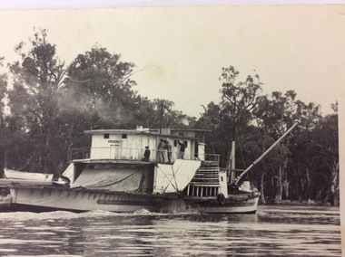
 Port of Echuca
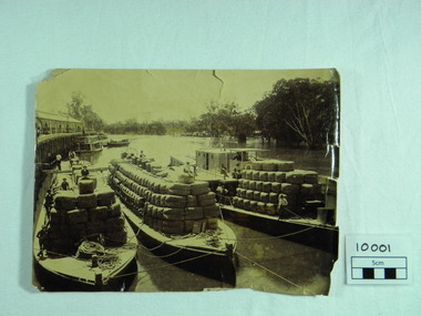
Photograph, P.S. Rodney with barges Horace & Nelson, c.1890
P.S Rodney with barges Horace & Nelson laden with wool bales bought into the Port to be unloaded onto rail trucks to go to markets in Melbourne. c.1890 Paddlesteamers travelled the river systems to bring wool from out- lying properties into the Port of Echuca to be transported by rail to Melbourne. This was prior to road & rail transport in the 1800'sOne of thousands of photos taken depicting the transportation of wool from out- lying properties to the rail head at Port of Echuca using paddlesteamers. P.S.Rodney alongside barges Horace & Nelson, tied to historic Echuca Wharf, with Pride of the Murray paddlesteamer & barge in back ground all vessels loaded with wool bales and crew resting on these. Riverbank lined with red gums. Handwritten in pen on lower left back corner "Rodney with barges Horace & Nelson c. 1890"farming, economy, p s rodney, port of echuca, wool bales, wharf, barges, horrace, nelson, paddlesteamer rodney, echuca -
 Port of Echuca
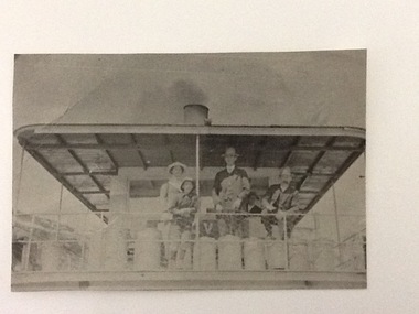
Black & white photograph
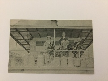
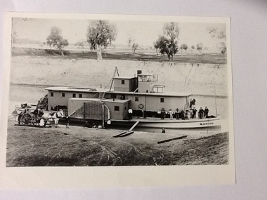
Black & white photograph of 2 men, 1 girl and 1 boy on upper deck of P. S. Kelvin. In the background is a 3rd man, Hugh Price, at the wheel. Documented as being on mail run and at the Murray BridgeDemonstrates passenger transport and travel along the river as well as the delivery of mail services between rural communities.Black & white photograph of 2 men, 1 girl and 1 boy on upper deck of P. S. Kelvin. In background is a 3rd man, (Hugh Price) at wheel. Documented as being on mail run and at the Murray Bridge Echuca.In pencil on back : Kelvinp.s. kelvin, murray bridge, mail run, paddlesteamers, murray river, hugh price -
 Port of Echuca
Black and white photograph
A copy of a black and white photograph of paddle steamer travel along the Murray river. It shows passengers (2 men, 1 girl, 1 boy) on the upper deck of the P. S. Kelvin, around the late 1890-1900. In the background is a third man, Hugh Price, at the wheel of the paddlesteamer. On the back of the photograph is documented as being on the mail run and at the Murray Bridge.Demonstrates passenger transport and travel along the river as well as the delivery of mail services between rural communities around the Murray Bridge, Blanchetown region in South Australia around 1890-1900.Copy of a Black and white photograph of 2 men, 1 girl and 1 boy on upper deck of P. S. Kelvin. In background is a 3rd man, Hugh Price, at the wheel. Documented as being on mail run and at the Murray Bridge (at Echuca)Kelvin on mail run, Murray Bridge. Hugh Price at wheel in rear.murray bridge south australia, p.s. kelvin, mail run, hugh price, cargo, price family collection -
 Port of Echuca
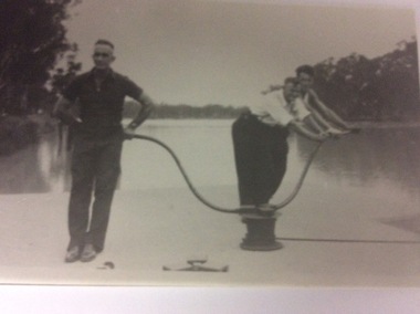
A black and white photograph of three men working on a lock, 20/09/1984
... opened to allow river transport to proceed. locks renmark euston ...This photograph shows three men opening a lock, manually using a lock capstan. The men are fit and strong. The river behind them appears to be very high. Not sure what the era is, but is obviously before looks were mechanised. The devise they are using is called a lock capstan.This photograph shows how locks were manually opened to allow river transport to proceed. A black and white photograph of three men working on a lock somewhere on the Murray River in South Australia. The device they are using is called a lock capstan.Written on the back in lead pencil Price. Opening up lock -probably Lock 7, Renmark. Maybe Euston.locks, renmark, euston, price family collection, murray river, capstan, lock capstan -
 Port of Echuca
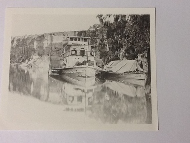
Black and white photograph, Approx.1980
... and social significance being typical of transport on the rivers ...Details of P. S. Queen: construction: composite 16 h.p. Registered tonnage: gross 128, net 92. Dimensions:L.103.3 ft B.18.5ft. D 5.7ft. Port and date of registry:Adelaide, 1880, no.43, 154. Built at Goolwa, S.A., 1865!. Owner: Chas Oliver. Lengthened in 1872. Details of barge Bourke. Construction:wood. Tonnage: 124. Dimensions:L 108.5 ft X B 20.5 ft X D 8.0 ft. Port and date of registry:Adelaide, 1898, no. 74, 771. built at: Miland, S. A. 1876. Owner: A. L. Land seer. Information from "The register of Australian & N. Z. Shipping 1898. This photograph has historical and social significance being typical of transport on the rivers systems of Australia in the late 1800s. Paddlesteamers carried supples to settlers and then carried their produce such as Wool and other produce down the rivers to markets or to be transferred by rail to the major ports such as Melbourne or Adelaide. Black and white photograph of P. S. Queen with the barge Bourke rigged to its side. Photographed in a gorge where boats appear to be moored. Photograph taken from the bow of the Queen with 3 people visible on the port side of the boat and there appear to be sacks stacked on the front of the boat. The barge Bourke has a tent structured tarp over it. Copy of an original photograph (date unknown)Inscription in pencil on reverse:Queen. On the photograph can be seen "Queen" on the bow and partically on the wheelhouse. The barge has "Bourke" visible on its bow.p. s. queen, bourke barge, paddle steamers -
 Port of Echuca
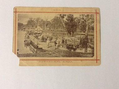
Photograph (sepia), approx 1850's
Sepia photograph of Hopwood's Punt, showing the gangway extended to river bank. There are 5 workmen, dressed in work clothes and boots, at the front of the punt and 2 gentlemen, dressed in coats and umbrellas. Stock, produce (possibly wool bales) and people are on board. There are 3 horses hitched to a wagon and behind there looks like a large consignment of wool bales. There appears to be women at the side of the punt (1 with an umbrella up). At the side of the punt there appears to be a passenger landing. There is also a small row boat tied to the side of the punt. Wagons, barge and possibly other punts are in the background. There was a painting of this scene by J. C. Armytage around 1857.This is a very good example of the cargo, people, produce and animals, that were using the punt to cross the Murray river in the late 1800s. The difference between workers and gentry can be seen as well as the modes of transport at this time.Sepia photograph of Hopwood's Punt, showing the gangway extended to river bank. Stock, produce (possibly wool bales) and people are on board. Wagons, barge and possibly other punts are in the background. Mounted on buff cardboard printed with red lines and letters.On the front at the top, above the red boarder "Royal", at the bottom below the red boarder "Hopwood's Punt, Echuca". On the reverse, "W. B. Payne, Darling St., Echuca"murray river, echuca, hopwood's punt, j. c. armytage (painter) -
 Port of Echuca
Black and white rectangular photograph, 1950?
The paddle steamer P. S Pevensy appears to still be a working steamer in this photograph. The boat seems a bit dishevelled and the workers are doing repairs on her, while she is still steaming up the river. If this photograph was taken in 1950, that would have been well before the development of the Tourism Industry in the Murray Darling area. This would explain the number of workers and the fact that they were doing maintenance while the Paddle Steamer was still working. She does not appear to be towing a barge, but a large tarpaulin could be covering a load for transport. This picture holds significance because it shows a paddle steamer in use before the Tourism Industry had developed in the Murray Darling region. The paddle steamer which now carries passengers every day has been renovated to cater for passengers cruising up and down the river. Here is this photograph the P.S Pevensy looks a bit dishevelled and untidy.This is a black and white rectangular photograph of the P.S Pevensey. Four people can be seen painting the wall of the cabins on the upper deck. A person can also be seen kneeling on the back deck working on something lying on the back deck. A wooden boat is nearby, also on the back deck. The boat is steaming and appears to be moving upstream. There is along pole at a 45 degree angle attached to the very front of the paddle steamer.On the front of the photograph written on the paddle steamer can't be seen the words "PEVENSEY. Melbourne." Written on the back of the photograph in lead pencil " M4414-17. K4". p.s pevensey, paddle steamers -
 Port of Echuca
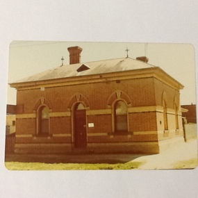
Colour photograph, Approx 1979
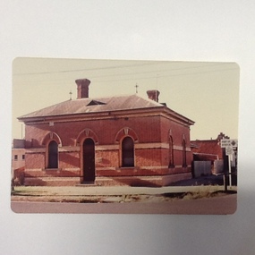
Customs building: built 1884 to handle goods entering Victoria up to 1901. Building classified B by National Trust.Customs houses, of similar design, were built along the Murray river to collect taxes on goods transported from N. S. W. to Victoria. The taxes were collected up until Federation in 1901. The Victorian railways used it as an office until about the 1960 when it became a private dwelling. The Customs House at Echuca is now owned by The Port of Echuca and has been used to house a wine tasting businesses, cafe and local produce retail and art gallery.Colour photograph of Customs House at Echuca port.In ink on reverse: "8A"customs house, echuca, echuca historical buildings, echuca, port of (customs history) -
 Port of Echuca
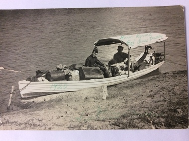
Postcard, February 1920
This is a photograph of three men in a heavily laden boat. The boat is tied up to a stick inserted into the bank. There is a black cocker spaniel dog also in the boat. The man in the middle back is believed to be John Trestrail Freeman. The card has been addressed to his wife. Dolly Freeman née Dolly Dean. The other two men , Bot and Paddy cannot be identified. The men are obviously travelling up the river. There is a motor on the back of the boat. The luggage includes a Gladstone bag, suit cases and boxes, indicating they have been travelling a long distance.This photograph is significant because it shows the type of transport available in the 1920's. Also it shows the conditions the three men travelled in. The boat was small, heavily laden with a simple motor. River traffic in 1920 would have been sparse. Also a journey from Echuca to Mildura would have taken weeks to complete.A rectangular black and white postcard showing three men and a dog in a heavily laden boat, which is tied up to the bank.On the back is printed W. GRIMWOOD/ POSTCARD/CORRESPONDENCE/ ADDRESS ONLY/KODAK AUSTRALIA . Handwritten in ink on the back are the words "To Doll from Bot, Tress, Paddy, River Rovers on Trip to Mildura Feb. 1920." Written on the front of the card in green ball point ink are the words "River Rovers Bot Tress Paddy 1920". In the bottom right hand corner in green pen is written "Echuca to Mildura. Tress Freeman."freeman, john trestrail (jr.), mildura, murray river, river rovers, freeman, dolly -
 Port of Echuca
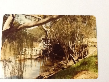
Colour photograph, Approx.1979
This photograph shows a punt (with a dingy tied to it ) moored to the wharf structure on the Murray river at Echuca. Punts were used to transport people and goods from one side of the river to the other.Punts were used to cross the Murray river at many spots before bridges were built. Henry Hopwood set up his initial business with punts across the Murray and Campaspe rivers, charging people, animals and vehicles to cross the rivers.Colour photograph of a punt tied to the port structure, seen through the foliage of gums on the river bank.On reverse:" This paper manufactured by Kodak"port of echuca, hopwood's punt, echuca, port of -
 Port of Echuca
Black and white photograph, Earliest 1897
... Built: 1897, at Milang, S. A. References: Book: "Murray River ...P. S. Marion Dimensions: 107 ft 11 in X 5 ft 3 in Tonnage: 157 tons Built: 1897, at Milang, S. A. References: Book: "Murray River Paddlesteamers" by D. Wardle. pp.22 Riverboats and Rivermen by W. Drake & M. PagePaddlesteamers were a common form of transport along the Murray river in the early 20th century. This photo shows a number of travellers on the boat, judging by their attire, workmen, cook, men in suits and ties as well as a group of people sitting on the bank, possible a woman and children with dog waiting for the boat to depart. There is also a horse drawn wagon with a number of people on and around it that could be waiting to pick up goods (or have unloaded) from the boat. At the back of the boat stacks of wheat bags (?) are visible.Black and white photograph of P. S. Marion moored by a river bank. There is a group of men standing towards the bow and a horse drawn carriage on the bank near the stern. Copy of an original photograph.On the front: MARION on the bow of the boat and on the wheelhouse. On reverse, in pen: Marion. where? Stamped in black: National Library of Australia.riverboats,, paddle steamers, p. s. marion -
 Port of Echuca
Colour photograph, 1977
Customs building: built 1884 to handle goods entering Victoria up to 1901. Building classified B by National Trust.Customs houses, of similar design, were built along the Murray river to collect taxes on goods transported from N. S. W. to Victoria. The taxes were collected up until Federation in 1901. The Victorian railways used it as an office until about the 1960 when it became a private dwelling. The Customs House at Echuca is now owned by The Port of Echuca and has been used to house a wine tasting businesses, cafe and local produce retail and art gallery.Colour photograph of Customs House at Echuca port.In ink on reverse: Dec.77-M: Print made by Kodak: Kodak. In pencil Customs Housecustoms house, echuca, echuca historical buildings, echuca, port of (customs history) -
 Port of Echuca
Photograph, Original photo C.1910. Copy 1984
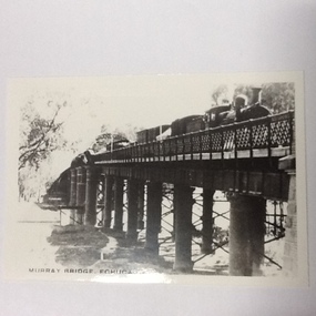
This photograph comes from the Dowell collection. Related to P000202. At the turn of the 20th century, the railway line carried produce from southern New South Wales and the Riverina to Melbourne. Goods trains were a very important mode to transport to our region and industrialisation of Echuca. Photograph of the Murray bridge at Echuca at low river with a goods train crossing the bridge. Image is seen from bank facing north from Echuca.Recto :"MURRAY BRIDGE Echuca"; Verso: "C.1910" "Low river"dowell collection, murray river bridge , echuca, murray bridge, echuca, steam engine goods train, railway, transportation, industrialisation