Showing 86 items matching "the cattlemen"
-
 Kiewa Valley Historical Society
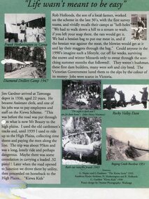
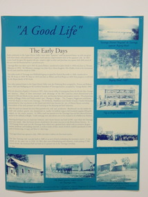
Posters – Set of 3 A4 posters depicting the early days and people in the Kiewa Valley
In the 1830’s, European pastoralists started moving south from NSW into the Alps. In 1836, cattle grazing began around Omeo and the runs spread out into the foothills. The higher country was used for summer grazing and huts were built for shelter and storage during stock mustering. The lure of gold brought many people to the Alps from around 1850 to 1900. Bushfires destroyed the forests around Melbourne in 1939 and the boom in house-building after World War II ked to increased demand for timber from the Alps. This resulted in the building of a network of roads which helped open up access to the Alps. The early 1940’s brought the first of many workers to the Alps for the planning and construction of the Hydro-Electric Scheme. These were the pioneers and early settlers of the Kiewa Valley and provided a wealth of characters and a tapestry of stories and adventures to be handed down to future generations.These 3 posters, which were most likely produced for promotional purposes provide a glimpse into the early lives of the pioneer families of the Kiewa Valley through pictures and verse. They show their lifestyle and outline the hardships they had to endure in living and working in the Alpine region. They also highlight the early arguments regarding grazing in the high country which would ultimately lead to the end of the long traditions of the high country cattle men. Set of 3 A4 size posters with black and white photographs and text and colour background depicting various parts of the history of the Kiewa Valley. 1. Titled - ‘Life wasn’t meant to be easy’ Describes early life for Kiewa Hydro workers. 2. Titled - ‘Cattlemen of the High Plains’ Describes a brief history of life of the cattlemen of the high plains 3. Titled – ‘There are Places I’ll remember’ Depicts early photographs of residents of the Kiewa Valley, also includes the words from a John Lennon song as per poster title. Printed on each poster – Poster designed by Dyanne Photography - Wodonga 1. Printed at bottom of poster – Sources: G Napier and G Easdown “The Kiewa Story” 1993. Southern Hydro Archives, N Hetherington and R Hollands. G Gardner “The Kiewa Kids” 1998. 2. Printed at bottom of poster – Sources: D Purland. Handwritten at top of poster- Poster 4 3. Printed at bottom of poster – Sources: B Roper, W Davies, D Higginson, H Ryder. Handwritten at top of poster- Poster 3 kiewa valley; tourism; lifestyles -
 Kiewa Valley Historical Society
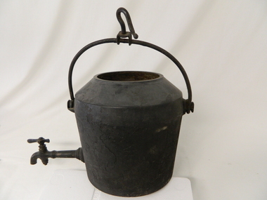
Pot Large with Tap, Circa 1950
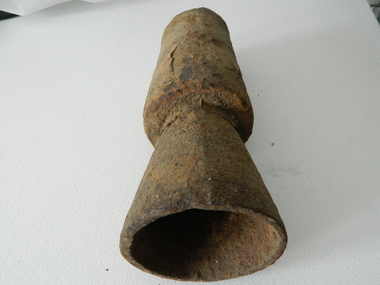
This type of cast iron kettle was used by pioneer families, mainly rural in the early 1900's upon open fires (log). It covered rural activities that needed a constant readily available source of boiling water, in or mainly outside the kitchen of homesteads. This kettle was used in the early to late 1900's for the refreshment of stock men and farmers that had irregular "tea" breaks under sometimes hard and gruelling conditions.This kettle belonged to and was used by a Kiewa Valley, pioneer family, the Roper Family. This kettle was moved from their Kiewa Valley property to their hut built on the Bogong High Plains. The Bogong High Plains area provided Kiewa Valley cattlemen a good supply of fodder to supplement their Kiewa Valley grazing areas. This "camp draft" activity , in the high plains, could take up to six weeks.This large cast iron modified camp pot (cauldron) has a long tap connection located at the bottom end. The "tap" is made from brass and has a simple elongated "bar" control swivel at the end to control the water flow. The tap suggests that only water was heated (to a constant boil) for the replenishment of cattlemen's, or other horse rider's, tea or coffee mugs. Refreshments at a "temporary" location on the Bogong High Plains. There was a "log" hut built by the Roper family as temporary accommodation for cattlemen and other family members.Ot the flat bottom "FIRST QUALITY 2 GALLONS"camp fire cooking utensils, hot plate, cast iron cooking appliance, drovers kitchen -
 Falls Creek Historical Society
Photograph - Ray Meyer at Blair's Hut
MEYER COLLECTION - FALLS CREEK PHOTOS In 1947 a determined group of like-minded State Electricity Commission (SEC) staff including Ray Meyer, the chief surveyor of the Kiewa Hydro-Electric Scheme, had a common interest that revolved around the skiing potential of the snow-covered high plains which included what is now the resort of Falls Creek. The six SEC employees, Toni St Elmo, Ray Meyer, Jack Minogue, Lloyd Dunn, Adrian Ruffenacht and Dave Gibson (together with their families) banded together to secretly build a 'hut' that was the first ski lodge at Falls Creek. Using a road built in 1930s to gain access to Falls Creek, their hut project was carried out in secret as efforts by other skiers were blocked by H.H.C. Williams – the engineer in charge of the Hydro Scheme. In 1946 Ray Meyer made a trip to the Lands Office in Melbourne. He came away with a 99-year lease on three acres that was ideally suited for a hut designed by Lloyd Dunn. Adrian Ruffenacht (Design Engineer for the KHS) had suggested where the group should build because of easy access to a spring for water. Much of the building material required was scavenged from derelict huts on the high plains. Due to the need for secrecy, the determined group worked on the hut in the evenings and weekends to avoid detection. During the building period the group had met at Echidna Rock (now known as Eagle Rock) where Skippy St Elmo announced, "This is my favourite ‘Skyline’.” And so the first lodge in the area at Falls Creek Ski Resort came into existence. With the development of the International Poma in the 1970s, the Skyline Lodge, which was sited between the ski-lift’s pole one and pole two, was demolished. However, the legacy of Ray Meyer, Toni St Elmo, Jack Minogue, Lloyd Dunn, Adrian Ruffenacht and Dave Gibson and Skyline lives on in the vibrant atmosphere of Falls Creek Resort. The MEYER COLLECTION documents developments on the Kiewa Hydro Scheme and their life at Falls Creek from the mid 1930s to 1960s.This image is significant because it documents the activities of a prominent family in Falls Creek, VictoriaA photo of Ray Meyer at the Kiewa River near Blairs Hut. The original hut, built by cattlemen Frank and Tim Blair in 1923-24, was burnt down around 193o. It was rebuilt by Frank and his son in 1932. It is constructed of Alpine Ash.ray meyer, blairs hut, falls creek, victorian snowfields -
 Lakes Entrance Historical Society
Book, Stephenson Harry, Cattlemen's Huts of the High Country, 1980
A record of the early development of Victorias Alpine Region by pioneer cattlemen, early settlements long since abandoned and the families who established them, and the many huts built as refuges during harsh conditions, many huts destroyed by bushfires,sbeef industry, settlers -
 Kiewa Valley Historical Society
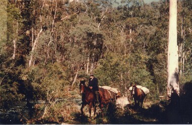
Photo: Coloured - Cattleman riding followed by packhorse
Cattlemen from the Kiewa Valley had huts up on the High Plains. Each Summer they would take their cattle up to the High Plains for grazing.Coloured photo of a Cattleman riding along a bush track and followed by a packhorse. cattlemen, pack horses -
 Kiewa Valley Historical Society
Tuyere Pipe, circa mid to late 1900's
This tuyere (word from French origin) was used by professional blacksmiths and or cattlemen before and during the Kiewa Hydro Electricity Scheme was being constructed. The need to use a furnace or forge in the shaping of metal rods, horse shoes and pipes is both a rural necessity and a construction, on site requirement. The "inventiveness" of cattlemen and construction workers to produce metal objects not available "off the shelf" is one of the inherent traits not only of rural self sufficiency but in the "pioneer" days of rural isolation one of survival.This tuyere is of great significance to the Kiewa Valley and its regions because it highlights one of the greatest strengths of the rural (especially isolated) life and its folk living there, and that is the great human factor of adaptability and survival techniques in sometimes harsh and demanding environmental circumstances. The inventiveness and the attitude, "she'll be right mate", demonstrates life on the land where specialised blacksmith activities can be found in non "professionals" because of the fact that "someone" has to do the job. This is one of the differences between country "rural" life and that found in cities and larger towns.This iron cone shaped tuyere has a small hole (diamenter 25mm) starting within an ever enlarging cone (amplification of the air pressure going through) delivering varying hot or extremely hot air into a furnace or hearth which intensifies the heat to allow the "shaping" of metal objects. The larger "flared" cone extension allows for the directed air to be spread and not concentrated.blacksmith tool, tue, bellows, fashioning metal, forge manufacturing process -
 Kiewa Valley Historical Society
Spade - Long handled
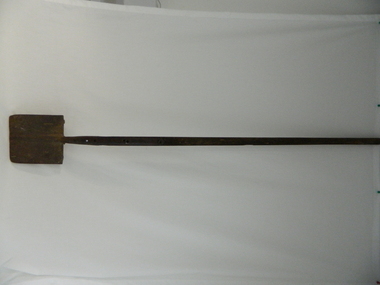
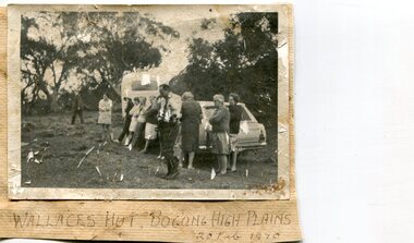
The cattlemen's huts on the High Plains were used as shelter during the herding of the cattle on the Bogong High Plains during summer. Wallace's Hut is the oldest cattleman's hut and was owned by the Wallace family.This long handled spade was used by the 3 Wallace Brothers to dig 6 post holes for the posts of Wallace's Hut in 1889. On the 6th hole they struck rock 6 inches down but they persevered and succeeded in chipping away the rock to the required depth of 3 feet. This is the post in the south east corner.This long handled spade was made in Birmingham and was used by the 3 Wallace Brothers to dig 6 postholes for Wallace's Hut on the bogong high Plains in 1889.Birmingham 3 Cast Steel 234bogong high plains. wallace's hut. cattlemen's huts. tool. -
 Falls Creek Historical Society
Journal - Voice of the Mountains, Mountain Cattlemen's Association of Victoria, 1982
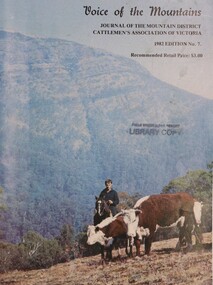
The Mountain Cattlemen's Association was officially launched in November 1967 with the objective of preserving and maintaining good relations and understanding within the cattle industry and between that industry and all bodies and organisations with which the industry is associated in the spheres of Government, land use and marketing. Since 1972, the Mountain Cattlemen’s Association of Victoria has produced an annual journal "The Voice of the Mountains". This journal commemorates the activities and history of the previous twelve months and bygone years of cattlemen and their families.A journal of 47 pages including table of contents, articles and illustrations. The front cover features a photograph, "Mustering Herefords on the Bluff". The title is in black ink at the top left hand corner :"Voice of the Mountains, Journal of the Mountain District Cattlemen's Association of Victoria, October 1982 Edition No 7The Mountain Cattlemen's Association was officially launched in November 1967 with the objective of preserving and maintaining good relations and understanding within the cattle industry and between that industry and all bodies and organisations with which the industry is associated in the spheres of Government, land use and marketing. Since 1972, the Mountain Cattlemen’s Association of Victoria has produced an annual journal "The Voice of the Mountains". This journal commemorates the activities and history of the previous twelve months and bygone years of cattlemen and their families. mountain cattlemen, high country cattle -
 Falls Creek Historical Society
Book - Cattlemen & Huts of the High Plains, Harry Stephenson, 1980
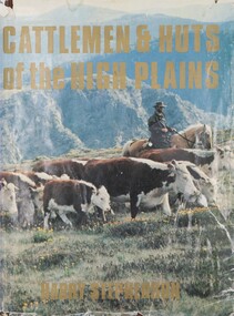
... Cattlemen & Huts of the High Plains...Cattlemen & Huts of the High Plains ...This book records the development of Victoria's alpine regions by the pioneer cattlemen. They came from the Monaro in the 1830s to reach the Plains of Omeo while others advanced up the Murray tributaries to discover the Bogong High Plains in the 1830s and the Gippslanders moved their herds to Alpine pastures in the 1860s. The cattlemen, the snow plain pastures, the mountain scene and the bush huts are described and illustrated in this volume. It records an era in Australia whose story is becoming lost.This volume of 350 pages includes 34 maps, 326 illustrations and diagrams. It has a brown cloth with white lettering and a pictorial jacket featuring cattlemen on the High Plains. It includes an index and bibliography. The front page has an inscription which indicates it had been given to Ore Frueauf of Falls Creek.non-fictionThis book records the development of Victoria's alpine regions by the pioneer cattlemen. They came from the Monaro in the 1830s to reach the Plains of Omeo while others advanced up the Murray tributaries to discover the Bogong High Plains in the 1830s and the Gippslanders moved their herds to Alpine pastures in the 1860s. The cattlemen, the snow plain pastures, the mountain scene and the bush huts are described and illustrated in this volume. It records an era in Australia whose story is becoming lost.victorian high country, mountain cattlemen, victorian high plains -
 Wodonga & District Historical Society Inc
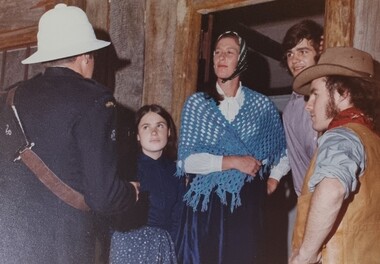
Album - Ringer's River by Des Martin - Plate 16 - The trial takes place
Klinberg and his men stand trial in Overton in a courtroom packed with sympathisers. Both Justices of the Peace assisting the Police Magistrate are members of the Cattlemen's Association, and manage to keep the sentence down to a heavy fine. Henry MacLean as the Police Magistrate Maj. Hardwick and James McGrath as the Justices of the Peace Bill Tenteye as Klinberg.The album and images are significant because they document literature written by a prominent member of the Wodonga community. The presentation of this precis was supported by several significant district families and individuals.Ringer's River Album Coloured photo Plate 16des martin, many a mile, ringer's river, northeast victoria stories -
 Orbost & District Historical Society
black and white photograph, early 20th century
Before 1850, Bendoc was peopled by a few Chinese settlers. History sources reveal little of its beginnings, Cattlemen used the spot as a temporary watering place and Ben Boyd sometimes brought his cattle down from the Monaro High Plains to be docked. “Ben's Dock” then is a possible derivation of the name Bendoc. (info. Bendoc Progress Association)This is a pictorial record of Bendoc in the late 19th -early 20th century. It shows early horse-drawn transport.A black / white photograph of a horse-drawn wagon and a man on a horse outside a wooden building.on back - "stop before Bendoc Hotel"bendoc transport-horse-drawn -
 Kiewa Valley Historical Society
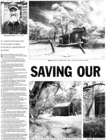
Newspaper article- Double page article. Pages 30 & 83 from the Herald Sun Newspaper. February 18, 2006 regarding preserving Victoria’s High Country Huts
The arrival of explorers Hume & Hovell in 1842 brought about the widespread clearing of land in the valleys for pastoral uses and the displacement the original inhabitants in the high country which became a boon for cattlemen due to extensive lush summer grazing for cattle. High country cattlemen built a variety of huts for shelter and storage, when driving cattle up to the plains in summer, during mustering and bringing the cattle down from the mountains before winter closed in. These same huts now provide shelter from the elements for hikers, bush walkers and skiers. Wallace’s Hut is the oldest of the Cattleman’s huts still standing in the Alpine National Park and is classified under the National Trust. Due to their age and the ravages of the elements, including bush fires, many of the huts have been destroyed, or are falling into disrepair. Groups of willing volunteers are now working to preserve as many of the huts as possible with restoration or rebuilding.The numerous cattleman’s huts of the Alpine National Park and the colourful characters who erected them represent a significant part of the history of the high country area and early cattle grazing, which has been the theme for many poets and film-makers alike. They also have a significant role in the early days of the SECV when they were used by surveyors and other workers for shelter and temporary accommodation. More recently the huts have functioned as shelter for hikers and skiers caught out in the elements and a refuge along the long trek for bush walkers. They are a popular attraction for tourists and feature prominently in much of the tourist information of the region. Black and white double page Newspaper article from the Herald Sun Newspaper of February 18, 2006 regarding the efforts of Mr David Oldfield to preserve Victoria’s remaining High Country Huts through his photography and efforts to restore old and Re-build missing ones. Article shows a photograph of David Oldfield and some of his photographic work of the huts. Page number and date printed at top of each page 30 Herald Sun, Saturday, February 18, 2006 Herald Sun, Saturday, February 18, 2006 83 cattlemen's huts; david oldfield; bogong high plains; wallace's hut; high country; alpine national park -
 Kiewa Valley Historical Society
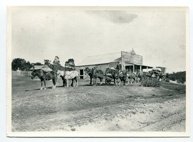
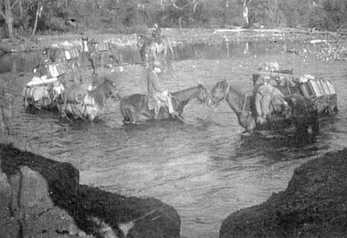
Photographs and copies of photographs of the pack horses and early horsemen who transported supplies to outposts in the Bogong High Plains, via cattle tracks before access roads were made
In the mid to late 1930’s survey outposts were established to plot the early stages of the Kiewa Hydro Electric System for the SECV in the Bogong High Plains. Before any roads were built, the old cattleman’s tracks were used with packhorses to deliver supplies, wages and mail and collect timesheets and correspondence from the workmen and dam builders living in canvas tents and at the outlying survey posts. The trip up the mountain was long and hard and dangerous for both horse and man Most of the men of the survey teams were not bush-men and were often ill equipped for the harsh weather and living conditions of bush camping, often arriving in their city clothes ready for work. The tent city at Bogong was destroyed by bush fires in 1939 after which an access road was built from Mt Beauty to transport building materials for more permanent dwellings for workmen. Pack horses continued to be used for transporting goods etc. to workers further up the mountain.Without the work of horsemen and their pack horses providing supplies and communications for outlying outposts, surveying and early planning for the Kiewa Valley Hydro Electric scheme could not have gone ahead and the dams and power stations which support the system could not have been constructed. The Hydro-electric scheme, and the workers who planned and built it play a major part in the early history of the Kiewa Valley and many original families still remain living, or have ties with the local area.: Set of 21 black and white photographs and copies of photographs depicting the pack horses and the men who handled them, transporting supplies and correspondence to the outlying camps and survey posts in the Bogong High Plains, via the rough cattlemen’s tracks. Photographs also show the early tent camps of the workers. Some photos mounted on A4 white paper. Some photos enlarged to A3 poster size for display1. Handwritten on back – Max Lawrence 2. -8 No inscriptions 9. Handwritten on back- Packing in supplies for early workers of the Kiewa Hydro scheme. There were no roads in the early days of the scheme 10. Printed on bottom of photo- Roper’s cattle on road below Howman’s Gap 11. Handwritten on back – Roper’s et al about to leave for the high plains 12. Printed under photo- Syd Ryder at the Pretty Valley Cut-Out (JBR) 13-16. No markings 17. Printed under photo- Gwen Talbot visits the Camp area. 1937 18. Handwritten on back- 14/1 Barbara Talbot 19. No markings 20-21. No markings 22. Printed under photo- STATE ELECTRICITY COMMISSION OF VICTORIA. Date: 15-3-45 Time: 8.0pm No: K 1838 Kiewa Hydro-Electric Works, Investigations 1944-1945 – Survey Camp at Young’s Hut pack horses; bogong high plains; survey posts; supplies delivery -
 Kiewa Valley Historical Society
Posters - 9 in the Set, The Famous Bogong School, Beyond the Gate-(up and down) , A Good Life, The Precursors, Great Expectations, Windows to Yesterday, c1998
These posters were produced for a display during the Mt Beauty Music Festival in 1998. They cover the history of the Kiewa Valley from the early days, farming and the Kiewa Hydro Electric Scheme. These posters summarise the history of the Kiewa Valley and were compiled using memories, publications and documents. The posters are clear and useful for display.Large glossy cardboard posters: Mostly blue and white with photos and writing of the history of different aspects of the Kiewa Valley 1. Bogong School 2. Bogong Village 3. Mt Beauty 4. Tawonga 5. The Early Years 6. Kiewa Hydro Story 7. The Kiewa Valley Runs 8 & 9. Cattlemen & Huts of High Plains. Created for display with sources sighted. See KVHS 0956 bogong state school. bogong village. state electricity commission of victoria. tawonga. surveyors. mt beauty. camps. kiewa hydro electric scheme. kiewa valley. -
 Orbost & District Historical Society
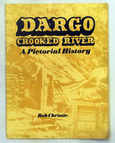
book, Enterprise Press Pty Ltd, Dargo Crooked River, C 1994-1997
This is a pictorial history of the Crooked River district.This is a useful reference tool on the history of gold mining in the Dargo area.A thin 56 pp paperback book titled,"Dargo Crooked River a Pictorial History". On the yellow front cover is a sepia photograph of a man standing outside a rough wooden hut. The title and author are printed in black text over this. The book contains Black / white photographs and the history of Dargo and Crooked River. The information is divided int decades. Inside there is a newspaper cutting of Victorian cattlemen on Junction Plain near Omeo.dargo-crooked-river gold-mining east-gippsland-history -
 Kiewa Valley Historical Society
Photos: black and white - Working Horses
Photo No. 9 Horses Crossing River - Packing in supplies for early workers on the Kiewa Hydro Scheme. There were no roads in the early days of the Scheme. Horses from the Kiewa Valley were used to transport goods prior to roads and vehicles being available1. Horses crossing river - 2 copies 2. Pack horses 3. Rider with pack horse -x2 and See (KVHS 1396) 4. Cattle entering river 5. Horses on High Plains x2 6. color - Horses in River 7. Pack horses and carts 8. 4 Cattlemen with dog in foreground 9. Color - Horses crossing river 10.Horses and tents - Harry Trimble x2working horses, horses from the kiewa valley -
 Kiewa Valley Historical Society
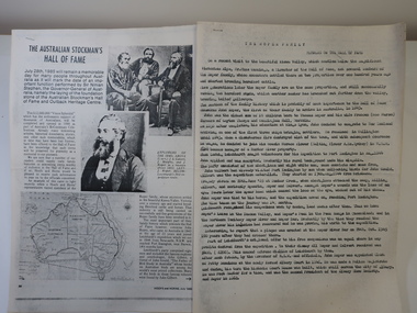
Papers - Roper Family, The Australian Stockman's Hall of Fame
The Australian Stockman's Hall of Fame is a museum located in Longreach, Queensland, Australia, which pays tribute to pioneers of the Australian outback. The centre is also dedicated to Australian stockmen who have shown bravery and courage. Registered in 1974. On July 28th 1985 the foundation stone of the Australian Stockman's Hall of Fame and Outback Heritage Centre was laid. Hoofs and Horns magazine was established by R.M.Williams in 1944 and ceased in 2005. It was aimed at cattlemen and horsemen.'The Roper family's ancestors settled in the beautiful Kiewa Valley, Victoria over a century ago and started breeding Hereford cattle and horses.' This is their interest in Hoofs and Horns but the Hall of Fame is interested in 'John Roper, who came to Australia in 1843 at the age of 23 years and joined Leichhardt's expedition ...'2 papers - Hoofs and Horns, July 1985, Page 88 and page 90 printed with photos and map. The article has the title: 'The Australian Stockman's Hall of Fame' 2 papers - Title The Roper Family compiled by Wilma Davies (nee Roper) and Mr Mike Cummings. Members of the Hall of Fame.. australian stockman's hall of flame, hoofs and horns magazine, cattlemen and horsemen, the roper family -
 Kiewa Valley Historical Society
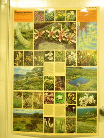
Map / Chart, Vegetation Map & Guide to Alpine Flora: Rocky Valley, 1982
This poster is of Rocky Valley is on the Victorian High Plains where the State Electricity Commission of Victoria worked on the Kiewa Hydro Electric Scheme and also where cattlemen brought their cattle up during summer at various times. Its significance is due to it shows the flora of the area after the Kiewa Hydro Electric Scheme Rocky Valley damn has been build and therefore is a valuable for comparison to see what plants are there now after this information on this poster was complied. Historic: Comparison of the flora at Rocky Valley with other areas on the Victorian High Plains and with Rocky Valley before and after the Kiewa Hydro Scheme and / or grazing there. Is therefore research significance and interpretive capacity due to this compatibility value.Laminated double sided vegetation map and guide to the Alpine flora of the Rocky Valley area, with photographs of plants and vegetation.rocky valley. alpine. flora. vegetation. plants. s.e.c.v.. cattlemen. victorian high plains. -
 Kiewa Valley Historical Society
Photographs x 2- Bus tour of Wallaces Hut, 20/02/1970
Wallace's hut was built in 1889 and is probably the oldest surviving hut on the high plains of north-east Victoria. It was built in six weeks by Irish immigrant brothers Arthur, William and Stewart Wallace among old snow gums on a grassy plain above the snowline. The brothers held grazing leases on the High Plains and the hut was built to provide shelter for the cattlemen working there. It is probably the oldest hut on the Victorian high plains. It is part of the early history of hydroelectricity in the state and has links with early SEC meteorological data recording in the area Apart from its historical significance, Wallace’s Hut is a popular stop for tourists and photographers and is the starting point for the Wallace’s Heritage trail, which is a popular and well used hiking track, by locals and visitors alike.2 black and white photographs mounted on buff card. Photos taken during a bus trip to Wallace's Hut on Feb. 20, 1970 1. Group of local Kiewa Valley residents on a bus tour to Wallace's hut 2. Group of adults and children pictured outside Wallace's hut1. Handwritten in black ink on bottom of photo 'Wallace's Hut, Bogong High Plains, 20 Feb, 1970 2. No markingswallace's hut, bogong high plains, bush walking, cattlemen -
 Kiewa Valley Historical Society
Roper's Hut Memorabilia
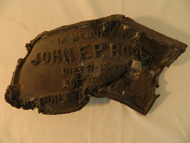
Roper's Hut was built in 1939 and was burnt down in 2003. It was rebuilt in 2008 and is situated on the Bogong High Plains on Duane Spur (where Duane's hut had been before it too was destroyed by (1939) bushfires, between Mt Nelse and Big River. The original hut was used as a shelter for cattlemen who grazed their cattle on the High Plains during summer. The Victorian High Country Huts Association Inc. members and friends helped rebuild the hut which is now used as an emergency shelter for visitors to the High Plains.The memorabilia is significant as the items belonged to the Roper family who were one of the original settlers of the Kiewa Valley and one of the original families who drove their cattle up to the Bogong High Plains. The burnt plaque and forks and the rebuilding of the huts (Duane's & Roper's) are significant as bush fires are a constant threat to the Bogong High Plains destroying large areas at a time.1. Bronze Plaque and 2 damaged forks from Roper's Hut which was destroyed by bush fires in 2003. 2. DVD & USB and hard copy photos of the rebuild of Roper's Hut in January 2008.The plaque had 'In Memory of / John F. P. Roper/ died 3-12-1977 / Aged 78 years / He built the original hut Feb. 1939'roper's hut, cattlemen, bogong high plains, bronze plaque, roper family, bush fires -
 Wodonga & District Historical Society Inc
Album - Ringer's River by Des Martin - Plate 13 - A police informant and a trap avoided
Through his position as a stockagent's clerk Billy, a proper dingo if ever there was one, is able to learn that some of the cattlemen intend to beat the duty by swimming their newly bought cattle back to Victoria. Sneaking down the back alley to the Police Station he sells this information to the authorities. Only Lennie, the halfwit roustabout from the store, follows and observes him, and, by riding O'Day's horse out of town, prevents his friend from travelling with the drovers who get caught in the police trap. W.O. Tom Foster as a N.S.W. trooper.The album and images are significant because they document literature written by a prominent member of the Wodonga community. The presentation of this precis was supported by several significant district families and individuals.Ringer's River Album Coloured photo Plate 13des martin, many a mile, ringer's river, northeast victoria stories -
 Kiewa Valley Historical Society
Photographs x 2- Khancoban Station and Comet the horse
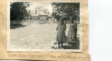
In 1824, Hume and Hovell were the first Europeans to pass through the district and graziers soon followed, impressed by the abundance of fodder and water. The first cattle run in the area was settled in about 1838 in what was known as Swampy Plains. Later, this run became known as “Khancoban Station”. Khancoban lies in the heart of the high country and is home of Australia’s mountain cattlemen. This heritage is celebrated in Banjo Paterson’s epic poem, “The Man from Snowy River”. In 1962, Bruce and Jo Chisholm relocated from Bond Springs to Khancoban Station, which Bruce had acquired in 1959. Khancoban Hereford and thoroughbred stud progeny were keenly sought after whenever they were presented in the sale ring. Bruce imported a stallion, Comet, from England in 1964. Comet stood at Khancoban for 15 years and was the sire of numerous winners, including Cobbermine, Kelly's Eye, Boack and Starglow. Photographs demonstrate local Kiewa Valley residents enjoying a community visit to the historic homestead at Khancoban Station which holds significance to the early history of the area. Its heritage is celebrated in Banjo Paterson’s epic poem, “The Man from Snowy River”. Also demonstrates a pictorial history of social activities undertaken during this period Black and white photographs mounted on buff card 1. Kiewa Valley residents visiting Khancoban Station 2. Photo of thoroughbred horse Comet and handler at Khancoban Station1. Handwritten in black ink below photo- Khancoban Station. Mrs. Young, Mrs Van Der Weyde 2. Handwritten in black ink above photo- "Comet' at Khancobankiewa valley residents, clare roper -
 Orbost & District Historical Society
black and white photograph, mid 1930s
This is a photograph of McKillop's Bridge probably taken just after its rebuilding. The current McKillop’s Bridge was built by the Country Roads Board in two stages between 1931-36, during which its height was raised after the original bridge superstructure was washed away in record floods of January 1934, prior to its original official opening. In its reconstructed form the original concrete abutments were turned into additional piers and the welded-steel trusses were cantilevered back over them to meet the new higher road approaches. "McKillops Bridge was Heritage listed due to its social and technological significance – the steel trusses' arc-welded construction technique was a pretty big deal in the 1930s. It was once an important route for cattlemen, who used the ford across the Snowy in the years preceding the bridge's existence"This is a pictorial record of McKillop's Bridge just after its construction.A black / white photograph of a wooden bridge across a river. At the bottom right is a man with his back to the camera. He is looking at flood debris on the bank. At the bottom left are two men near a pylon.on back - McKillops Bridgebridge-mckillop's snowy-river-bridge -
 Wodonga & District Historical Society Inc
Album - Ringer's River by Des Martin - Plate 15 - Confrontation with Police
Half an hour later her brother Keiran gallops up with the news that Artie Klinberg's mob has been ambushed by police. All the cattlemen other than he had been caught. Keiran escaped by jumping fences and coming home across country. Soon after Sergeant. Baker and Trooper Ryan arrive, and are refused entry by the widowed Mrs. Ellen O'Hara whose husband, some years previously, had been shot by police in mistake for a wanted bushranger. As he is acting mainly on presumption the chagrined Sergeant has to leave, warning O'Day to watch his company. Realising someone has "dobbed them in", Keiran decides it has to be George, "Microbe" Nugent, an unpopular fellow - traveller at loggerheads with Klinberg, and vows vengance. Maj. John Hardwick as Sgt. Baker. Mrs. Kerry Hardwick as Mrs. O'Hara. Bill Tenteye as Keiran.The album and images are significant because they document literature written by a prominent member of the Wodonga community. The presentation of this precis was supported by several significant district families and individuals.Ringer's River Album Coloured photo Plate 15des martin, many a mile, ringer's river, northeast victoria stories -
 Kiewa Valley Historical Society
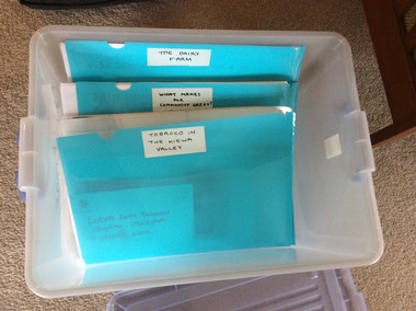
Folders - Exhibitions in the KVHS Museum
... Cattlemen on the High Plains ...The KVHS rotates its displays in the Mt Beauty Museum. These topics are researched and give a deeper insight into the chosen topic.A frosted white plastic tub holding blue plastic folders each with information and photos of each of the temporary displays that the KVHS has displayed in the Mt Beauty Museum. These include: 1. And Then There was Light 2. A Woman's Work is Never Done 3. Bogong Village - Camps 4. Cross Country Skiing 5. Electricity: Watts the Story 6. Here Comes the Bride 7. High Country Cattlemen 8. Indigenous People 9. Mt Beauty - Early; 10. Mt Beauty Sports 11. Not All Tea and Scones - C.W.A.12. Old School Days 13. Tawonga District General Hospital 14. The Buffalo Lodge 15. The Dairy Farm 16. Tobacco in the Kiewa Valley 17. What Makes our Community Great? Clubslight, women's work, bogong village, cross country skiing, electricity, weddings, cattlemen on the high plains, indigenous australians, mt beauty, c.w.a., schools, tawonga hospital, buffalo lodge, dairy farming, tobacco in the kiewa valley, community clubs -
 Falls Creek Historical Society
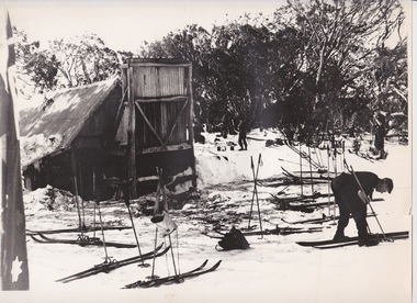
Photograph - At Wallace' s Hut
Wallace's Hut is the oldest surviving cattlemen's hut on the High Plains, built in 1889 by the three Wallace brothers - Arthur, William and Stewart. Their father David bought land at Kergunyah as well as grazing land on the banks of the Kiewa River, North East Victoria. Once the boys were old enough, the family followed the local squatters’ custom of taking their cattle up to the mountains for the spring and summer to fatten the mob, at the same time resting their home pastures. They decided to build a hut where they could shelter from the extreme mountain weather. The timber was cut from the forest about four hundred metres east of the hut, and the hearth stone was dragged in from Pretty Valley. The chimney had a base of rubble and above this iron sheeting on a timber frame. The slab walls were lined with hessian and later with tar-paper, and inside there was a bush table, sleeping platform and a rustic fire-side settle. The hut nestled among snow gums sheltered by a rocky outcrop. The names of the Wallace brothers were burnt into the tie-beams of the roof and at the back of the mantelpiece. The Wallace family’s lease expired in the late 1930s and the hut was bought by the State Electricity Commission to house staff on the High Plains and it became the first home of Toni and Skippy St. Elmo. The SEC covered the old shingles with iron, and later on the walls and chimney as well, and they added a lean-to. Wallace’s Hut is now owned by the Crown and maintained by Parks Victoria. It is on the Historic Buildings Register and is classified by the National Trust.This image is significant because it depicts an important heritage-listed structure and refuge for cattlemen and other travellers in Victoria's High Country.A black and white photograph of a skier outside of Wallace's Hut. Several sets of skis and poles are standing around and other skiers are in the background.wallace's hut, toni and skippy st. elmo, high country huts -
 Kiewa Valley Historical Society
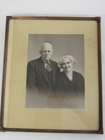
Photo Framed - Portrait of Walter and Ada Ryder, c 1930's
Portraits were taken professionally often on important occasions. As graziers from a prominent family in Redbank, Walter and Ada Ryder were well known and respected.Walter and Ada Ryder were pioneer high country graziers and cattlemen. Ada (nee Sullivan)'s family lived at Redbank. Their children were Walter, Victor, Beatrice, Vera, Lorna and Dorothy. Walter 1872 - 1954; Ada 1887 - 1983 Walter was a son of John and Annie Ryder - Walter's parents being one of the first settlers in the valley. According to Ada Ryder's notes and John Cooper's notes, Ryders were followed by Higginsons followed by Coopers in about 1867/8. Ropers held Mullindolingong Station/Mt Yorke Station, but had managers on the station before actually taking up residence about 1867/8. Whilst the Sullivans lived at Redbank (now known as Coral bank), the Ryders lived at Tawanga (correct spelling in those days) on Ryders Lane, Tawonga where John and Annie first built and lived; Walter and Ada then occupied the family home, followed by Vera Hore (nee Ryder) and the current owners Kevin and Rhonda Ryder.Black and white photo of an elderly man and woman both well dressed. Framed by cream cardboard 3.5 cm at sides and 5 cm top and bottom with a plain metal frame surrounding all sides with decorated corners. McPherson, Albury on front below righthand side of the photo.walter ryder; ada sullivan; cattle graziers; tawonga -
 Kiewa Valley Historical Society
Papers - Edmondson's Hut, The letter is dated 8th October 1974
Edmondson's Hut is a cattleman's hut on the Bogong High Plains. Jim Edmondson obtained Run 33 (near Mt Nelse) in the early 1930s. He pre cut the timber at his property in Tawonga and along with iron for the walls, chimney and roof took it up to the Bogong High Plains on pack horse. The hut's wall and ceiling were lined and the hut had a 'fairly good floor and bunks'. In 1971 the hut was donated to the Education Department and was approved for transfer by the Lands Department in 1974. Bogong Outdoor School camp has been using the hut for students to camp in as well as National Fitness parties when walking in the area. The upper Kiewa Valley was settled from the mid 1860s and from its earliest days cattle were taken on to the Bogong High Plains to graze during summer. Jim Edmondson took his cattle from the Kiewa Valley to Mt Fainter and later to Run 33, near Mt Nelse. His hut is significant in the history of Cattlemen's huts on the Bogong High Plains.Four A4 typed sheets on white paper - 1. Acknowledgement of transfer of Edmondson's Hut. 2. History of Visitors (to the hut) Prior to 1971. 3. Two poems. 4. One poem 1. Emblem of Education Dept. Centre top of page. Addressed to James Edmondson, Tawonga, Victoria. 2. Page headed History and Visitors prior 1971. 3. My Old black Poley Cow (and) Roper's Track. 4. So Long, Mates!education department. edmondson's hut. bogong high plains. cattlemen. poetry. cattleman hut. bush walking. -
 Kiewa Valley Historical Society
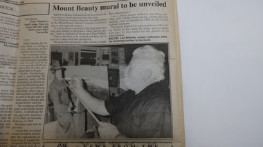
Newspaper Cutting - Mt Beauty mural to be unveiled
The Mount Beauty Mural Committee commissioned Leo Wimmer to paint the mural. On completion it was mounted in the Mt Beauty Supermarket. Leo was a well known master craftsman. See KVHS 0911Leo Wimmer lived in Mt Beauty and was a master craftsmanArticle re the mural painted by Leo Wimmer, master craftsman, depicting his representation of the valley. Includes black and white photo of Leo painting. The Alpine Times Tuesday January 31st 1995 page 4leo wimmer, mt beauty supermarket, cattlemen painting, s.k.pearce, bogong high plains -
 Kiewa Valley Historical Society
Collection of Papers and Articles - Cattle on the Bogong High Plains
Cattle grazing on the Bogong High Plains was a tradition for the farmers of the Kiewa Valley. Controversy re the environmental impact has recurred over the decades leading to action by the Australian Government.Articles and Papers collection re controversy re cattle grazing on the Bogong High Plains. Late 1970s to the late 1980s.cattlemen, bogong high plains, grazing, kiewa valley beef farmers