Showing 366 items
matching cartography
-
 Bendigo Military Museum
Photograph - Staff Retirement - Army Survey Regiment, Fortuna, Bendigo, c1989
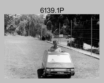
These two photos were most likely taken in the volleyball court area of the Army Survey Regiment, part of the grounds of Fortuna, Bendigo, in c1989. The occasion was probably to farewell SSGT Kevin Boehm, who was a cartographic draughtsman, after 22 years of service in the ADF. It is likely Bendigo Toyota was approached to loan their miniature Toyota Tarago; a vehicle used for marketing purposes. The novelty of this quirky “drive past” event was that Kev was well known as a part-time car salesman and often took the opportunity of assisting new staff in buying a car. Kev was a qualified pilot and often took time on weekends to take unit staff and their families on recreational flights over Bendigo and Albury-Wodonga. His other claim to fame was he was “charge happy”, a tendency to prefer charges against offending soldiers rather than offer them a warning.These two photos were most likely taken in the volleyball court area of the Army Survey Regiment, part of the grounds of Fortuna, Bendigo, in c1989. The photographs were on 35mm negative film and were scanned at 96 dpi. They are part of the Army Survey Regiment’s Collection. .1) and .2) - Photo, black & white, c1989, SSGT Kevin Boehm. No personnel are identifiedroyal australian survey corps, rasvy, army survey regiment, army svy regt, fortuna, asr -
 Bendigo Military Museum
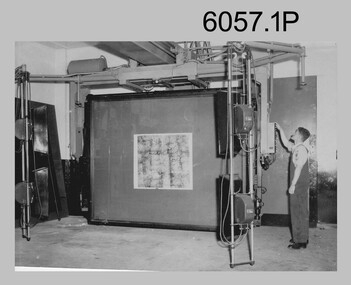
Instrument - Old Delft Scanning Stereoscope ODSS III, C. 1956
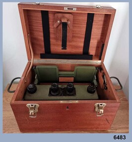
This is a superbly crafted cartographic mapping instrument. It is housed in its own high-quality purpose-built oak box. Made in the Netherlands from 1950 onwards. This instrument is from c 1956. it is a very high-quality military grade stereoscope that was generally used by photographic interpreters such as intelligence analysts but was equally useful for mapping activities. The stereoscope was used to examine 3D aerial photographic images. This instrument has a particularly useful capability to scan over the 3D stereo model using X and Y movement knobs, rather than having to physically move the aerial photographs. In the public and private sector it was also useful for photogrammetric interpretation for Forestry and Agricultural purposes. See also Bendigo RSL Collections Victoria item Number 6205.6P that shows the Old Deft Stereoscope in use at the Army Survey Regiment, Bendigo.This is an "Old Delft" scanning stereoscope with its reflecting carriage and legs. The Stereoscope is housed in its own purpose built wooden oak box that has dovetail joints, 2 x securing clips, 2 x handles and a lock (without key). The instrument is assembled by inserting colour coded legs into their matching slots."OLD DELFT SCANNING STEREOSCOPE ODSS III" "Patents Applied for" "OLD DELFT C4790" "MADE IN THE NETHERLANDS"royal australian survey corps, rasvy, fortuna, army survey regiment, army svy regt, asr -
 Flagstaff Hill Maritime Museum and Village
Map - World Map, Mappe Monde [Medieval Map of the World], 1910
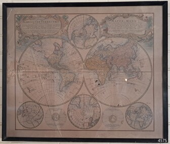
This map from the mid-18th century doesn't include the finer details of land and sea masses that we know today. The map was produced by German cartographer and publisher, Johann Baptist Homann (1663-1724) and published in 1746, after his death. Earlier versions were published, such as 1707 and 1716. The date can be calculated from the Roman numerals on the top left text area. This print of a map is significant for its connection with early world explorers. A comparison of maps over the centuries shows the progression of navigational technology, the countries who claimed the land they explored. The naming of even some Australian locations shows who had already made their mark on Australia in the early 18th century. The print shows the fine details included by the cartographer and the beauty included that makes it attractive and interesting even today. The map is also significant for its connection with German cartographer, Johann Baptist Homann, whose Homann publishing company was renewed in Germany for producing high quality maps and atlases. Map behind glass in dark brown wooden frame on beige paper. The Coloured hand drawn line drawings show different hemispheres of the known world in the mid-18th century. Beautifully drawn figures and decorative embellishments enhance the map. The text on the top right has an explanation of the Figures I, II, III, and IV. This print of the 1746 map was produced in England by Leisure Arts Ltd. "PLANIGLOBIL TERRESTRIS" "MDCCXXXXVI" [1746] "MAPPE_MONDE" [Medieval Map of the World] "LEISURE ARTS LTD" "Printed in England"flagstaff hill, warrnambool, flagstaff hill maritime museum, flagstaff hill maritime village, flagstaff hill maritime museum and village, shipwreck coast, world map, french map, 18th century map, leisure arts ltd, cartography, early exploration, cartographer, johann homann (1663-1724), exploration, naviagtion, 1746 planiglobil terrestris -
 Bendigo Military Museum
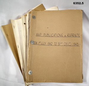
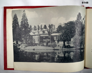
Administrative record - LHQ Cartographic Coy - Map Printing and Reprints 1 July 1942- 31 Dec 1947, LHQ Cartographic Coy, 1942-1947
The Land Headquarters Cartographic Company relocated to Fortuna Villa, Bendigo in 1942. With printing presses acquired from a number of civilian organizations it printed the maps needed for the Australian WW11 war effort. These records detail which maps were printed during those years. Photographs of the printing machines and the printers who used them are shown in Victorian Collections item 6148 LHQ Carto Coy Souvenir Booklet. 6352.1 Map Publishing and Reprinting Reports 1 July 1942 - 31 Dec 1943 6352.2 Map Publishing and Reprinting Reports 1 July 1943 - 31 Dec 1944 6352.3 Map Publishing and Reprinting Reports 1 July 1944 - 31 Dec 1945 6352.4 Map Publishing and Reprinting Reports 1 July 1945 - 31 Dec 1946 6352.5 Map Publishing and Reprinting Reports 1 July 1946 - 31 Dec 1947Five Manilla Folders containing Map Printing ReportsHand written on the Folder covers: 6352.1 Map Publishing and Reprinting Reports 1 July 1942 - 31 Dec 1943 6352.2 Map Publishing and Reprinting Reports 1 July 1943 - 31 Dec 1944 6352.3 Map Publishing and Reprinting Reports 1 July 1944 - 31 Dec 1945 6352.4 Map Publishing and Reprinting Reports 1 July 1945 - 31 Dec 1946 6352.5 Map Publishing and Reprinting Reports 1 July 1946 - 31 Dec 1947royal australian survey corps, rasvy, fortuna, army survey regiment, army svy regt, asr -
 Bendigo Military Museum
Pamphlet - An Introduction to Topographic Mapping, C 1991
This pamphlet was published by the Army Survey Regiment as an overview of the Royal Australian Survey Corps (RASvy), its role and unit structure circa 1991, prior to RASvy’s disbandment in 1996. The pamphlet comprehensively detailed the eight steps of topographic map production: Establish Survey Control, Aerial Photography, Aerotriangulation, Stereoplotting, Field Verification, Cartography, Printing and Storage/Map Distribution. Leading technologies used by RA Svy in 1991 included GPS control surveys, 5 colour printing on the Speedmaster offset press and bulk map packaging using the Map Handling Station (with guillotine). Digital map production was operating on the AUTOMAP 2 system, before the “Newheart” system upgrade two years later. Printed on the pamphlet cover was a portion of the plane tabled “four inches to a mile” map of Newcastle. This was compiled and surveyed in 1910 by LCPL A. Barrett, a member of the RAE Detachment, as part of the first major topographic mapping effort of Australia.This is a Royal Australian Survey Corp pamphlet with a historical map printed in colour on cardboard on both sides of the cover. There are 16 pages printed in colour on gloss paper, with photos, diagrams and descriptions. The pamphlet is bounded by two staples on its spine. Each of the 17 images were scanned at 300 dpi in JPEG (.jpg) format and stored on the attached 16 Gb USB memory stick. The images have been converted into MPEG-4 (.mp4) video format, 4Mb in size and runs for 2:16 minutes and is also stored on the memory stick.royal australian survey corps, rasvy, fortuna, army survey regiment, army svy regt, asr -
 Surrey Hills Historical Society Collection
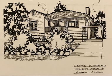
Drawing - Architectural drawing, 2 Austral Street, Surrey Hills by Margaret Picken, 1991, 1989
Margaret Picken (1950-) trained and worked as a cartographic draftsman from 1968-1975 within the mining industry. These skills were readily transferable to work as a property illustrator for the real estate industry. Process: “Sketches were ordered by phone initially as there were no mobile phones or computers then. I would take our 2 year-old son with me to the houses when the other 2 boys were at school. I photographed houses with a Polaroid camera and made a ‘thumbnail’ sketch while there. The photos were used to scale off a sketch in pencil and then that sketch was overlaid with drafting film and the ‘pen and ink’ was completed. This process was the only one I used the entire time. Polaroid photos gave an instant usable photo. I then delivered the sketches by hand to the offices. There were deadlines each week on a Tuesday.” “… about 2003 coloured photos began to take over the sketches and mainstream companies replaced sole traders like myself providing a one-stop shop for all advertising. I produced my last Real Estate sketches in late 2005.” Margaret Picken (1950-) trained and worked as a cartographic draftsman from 1968-1975 within the mining industry. This architectural drawing is one of a series created by Margaret Picken for a range of real estate agents in Melbourne between 1983 and 2005. Each work is signed and dated. Margaret Picken approached a number of historical societies in July 2020 with a view to donating her work. Sketches for post code 3127 arefheld by this collection. Others for suburbs including Ashburton, Balwyn, Camberwell, Canterbury, Blackburn, Box Hill, Burwood, Glen Iris, Hawthorn, Kew, Mont Albert North and Nunawading have been donated to the relevant historical group in those suburbs. (See Balwyn Historical Society, Box Hill Historical Society, Camberwell Historical Society, Hawthorn Historical Society, Kew Historical Society, Whitehorse Historical Society). In some cases, this collection also has a copy of the matching newspaper advertisement. Pen and ink architectural drawing on drafting film of 2 Austral Street, Surrey Hills (VIC) by Margaret Picken. The drawing, dated 1991, was commissioned by the Woodards real estate company.2 AUSTRAL ST., SURREY HILLS / MARGARET PICKEN - 91 / WOODARDS ~ C'WELLarchitectural drawing, houses, surrey hills / mont albert (vic.), artists, margaret picken 1950-, 1950, austral street -
 Surrey Hills Historical Society Collection
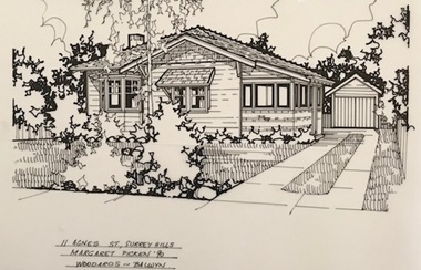
Drawing - Architectural drawing, 11 Agnes Street, Surrey Hills by Margaret Picken, 1990, 1990
Margaret Picken (1950-) trained and worked as a cartographic draftsman from 1968-1975 within the mining industry. These skills were readily transferable to work as a property illustrator for the real estate industry. Process: “Sketches were ordered by phone initially as there were no mobile phones or computers then. I would take our 2 year-old son with me to the houses when the other 2 boys were at school. I photographed houses with a Polaroid camera and made a ‘thumbnail’ sketch while there. The photos were used to scale off a sketch in pencil and then that sketch was overlaid with drafting film and the ‘pen and ink’ was completed. This process was the only one I used the entire time. Polaroid photos gave an instant usable photo. I then delivered the sketches by hand to the offices. There were deadlines each week on a Tuesday.” “… about 2003 coloured photos began to take over the sketches and mainstream companies replaced sole traders like myself providing a one-stop shop for all advertising. I produced my last Real Estate sketches in late 2005.” Margaret Picken (1950-) trained and worked as a cartographic draftsman from 1968-1975 within the mining industry. This architectural drawing is one of a series created by Margaret Picken for a range of real estate agents in Melbourne between 1983 and 2005. Each work is signed and dated. Margaret Picken approached a number of historical societies in July 2020 with a view to donating her work. Sketches for post code 3127 arefheld by this collection. Others for suburbs including Ashburton, Balwyn, Camberwell, Canterbury, Blackburn, Box Hill, Burwood, Glen Iris, Hawthorn, Kew, Mont Albert North and Nunawading have been donated to the relevant historical group in those suburbs. (See Balwyn Historical Society, Box Hill Historical Society, Camberwell Historical Society, Hawthorn Historical Society, Kew Historical Society, Whitehorse Historical Society). In some cases, this collection also has a copy of the matching newspaper advertisement. Pen and ink architectural drawing on drafting film of 11 Agnes Street, Surrey Hills (VIC) by Margaret Picken. The drawing, dated 1990, was commissioned by the Woodards real estate company.11 AGNES ST., SURREY HILLS / MARGARET PICKEN '90 / WOODARDS ~ BALWYNarchitectural drawing, houses, surrey hills / mont albert (vic.), artists, margaret picken 1950-, agnes street, californian bungalow -
 Surrey Hills Historical Society Collection
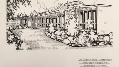
Drawing - Architectural drawing, 37 Albany Crescent, Surrey Hills by Margaret Picken, 1991, 1990
Margaret Picken (1950-) trained and worked as a cartographic draftsman from 1968-1975 within the mining industry. These skills were readily transferable to work as a property illustrator for the real estate industry. Process: “Sketches were ordered by phone initially as there were no mobile phones or computers then. I would take our 2 year-old son with me to the houses when the other 2 boys were at school. I photographed houses with a Polaroid camera and made a ‘thumbnail’ sketch while there. The photos were used to scale off a sketch in pencil and then that sketch was overlaid with drafting film and the ‘pen and ink’ was completed. This process was the only one I used the entire time. Polaroid photos gave an instant usable photo. I then delivered the sketches by hand to the offices. There were deadlines each week on a Tuesday.” “… about 2003 coloured photos began to take over the sketches and mainstream companies replaced sole traders like myself providing a one-stop shop for all advertising. I produced my last Real Estate sketches in late 2005.” Margaret Picken (1950-) trained and worked as a cartographic draftsman from 1968-1975 within the mining industry. This architectural drawing is one of a series created by Margaret Picken for a range of real estate agents in Melbourne between 1983 and 2005. Each work is signed and dated. Margaret Picken approached a number of historical societies in July 2020 with a view to donating her work. Sketches for post code 3127 arefheld by this collection. Others for suburbs including Ashburton, Balwyn, Camberwell, Canterbury, Blackburn, Box Hill, Burwood, Glen Iris, Hawthorn, Kew, Mont Albert North and Nunawading have been donated to the relevant historical group in those suburbs. (See Balwyn Historical Society, Box Hill Historical Society, Camberwell Historical Society, Hawthorn Historical Society, Kew Historical Society, Whitehorse Historical Society). In some cases, this collection also has a copy of the matching newspaper advertisement. Pen and ink architectural drawing on drafting film of 11 Agnes Street, Surrey Hills (VIC) by Margaret Picken. The drawing, dated 1990, was commissioned by the Woodards real estate company.37 ALBANY CRES, SURREY HILLS / MARGARET PICKEN -91 / WOODARDS ~ C'WELLarchitectural drawing, houses, surrey hills / mont albert (vic.), artists, margaret picken 1950-, albany crescent, 1980 -
 Surrey Hills Historical Society Collection
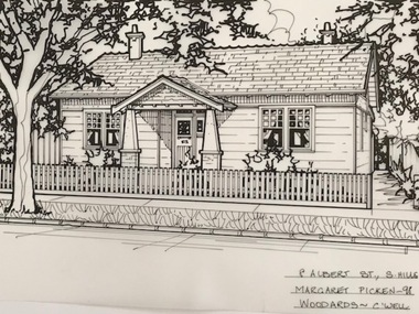
Drawing - Architectural drawing, 4 Albert Street, Surrey Hills by Margaret Picken, 1990, 1990
Margaret Picken (1950-) trained and worked as a cartographic draftsman from 1968-1975 within the mining industry. These skills were readily transferable to work as a property illustrator for the real estate industry. Process: “Sketches were ordered by phone initially as there were no mobile phones or computers then. I would take our 2 year-old son with me to the houses when the other 2 boys were at school. I photographed houses with a Polaroid camera and made a ‘thumbnail’ sketch while there. The photos were used to scale off a sketch in pencil and then that sketch was overlaid with drafting film and the ‘pen and ink’ was completed. This process was the only one I used the entire time. Polaroid photos gave an instant usable photo. I then delivered the sketches by hand to the offices. There were deadlines each week on a Tuesday.” “… about 2003 coloured photos began to take over the sketches and mainstream companies replaced sole traders like myself providing a one-stop shop for all advertising. I produced my last Real Estate sketches in late 2005.” Margaret Picken (1950-) trained and worked as a cartographic draftsman from 1968-1975 within the mining industry. This architectural drawing is one of a series created by Margaret Picken for a range of real estate agents in Melbourne between 1983 and 2005. Each work is signed and dated. Margaret Picken approached a number of historical societies in July 2020 with a view to donating her work. Sketches for post code 3127 arefheld by this collection. Others for suburbs including Ashburton, Balwyn, Camberwell, Canterbury, Blackburn, Box Hill, Burwood, Glen Iris, Hawthorn, Kew, Mont Albert North and Nunawading have been donated to the relevant historical group in those suburbs. (See Balwyn Historical Society, Box Hill Historical Society, Camberwell Historical Society, Hawthorn Historical Society, Kew Historical Society, Whitehorse Historical Society). In some cases, this collection also has a copy of the matching newspaper advertisement. Pen and ink architectural drawing on drafting film of 11 Agnes Street, Surrey Hills (VIC) by Margaret Picken. The drawing, dated 1990, was commissioned by the Woodards real estate company.37 ALBANY CRES, SURREY HILLS / MARGARET PICKEN -91 / WOODARDS ~ C'WELLarchitectural drawing, houses, surrey hills / mont albert (vic.), artists, margaret picken 1950-, albany crescent, 1980 -
 Bendigo Military Museum
Souvenir - Souvenir Booklet of Land Headquarters Cartographic Company, Australian Survey Corps "Fortuna" Bendigo 1942-45, Land Headquarters Cartographic Company, Australian Survey Corps, 1945
A Souvenir Booklet recording the Section photos and a Nominal roll of those who served 1942-45 at the Land Headquarters Cartographic Company, Australian Survey Corps located at "Fortuna Villa" Bendigo was produced at the end of WWII. Each member of the unit was presented with a copy of the booklet. The booklet besides being a great memory for those who served is a very valuable resource as it names the individuals in the photographs and very importantly records a Nominal Roll of unit members and their Military details. This booklet is one of those original booklets. The booklet has been reprinted on a number of occasions with different coloured covers. The first and original booklet had a red cover. Editions with brown, dark blue and black exist. The black covered edition was the last reprint. This booklet was donated by Carol Hargrave of Grenfell, NSW after discovering it in an old trunk that she purchased. A black covered edition was donated by a local Bendigo Antique Dealer in September 2024.A4 sized red cloth covered hard covered book mainly containing sub-unit photographs of section members and includes their names. 23 x double sided pages of photographs and 2 double sided pages of a Nominal Roll of those who served at Fortuna 1942 - 45. Each of the 50 pages were scanned at 600 dpi in JPEG (.jpg) format and stored on the attached 16GB USB Memory Stick. The images have been converted into MPEG-4 (.mp4) video format, 9Mb in size that runs for 4 Minutes and is also stored on the memory stick.royal australian survey corps, rasvy, fortuna, army survey regiment, army svy regt, asr -
 Bendigo Military Museum
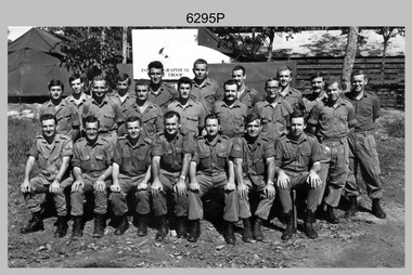
Photograph - Detachment - Army Survey Regiment, Bonegilla, Victoria, c1973
This is a set of six photographs of personnel from the Detachment - Army Survey Regiment taken in front of its main map production building at Bonegilla, Victoria in c1973. This cartographic map production sub-unit of the Army Survey Regiment operated in buildings owned by the School of Military Survey from 17th of June 1970 to the 30th of September 1985. A total of 800 topographic maps ranging in scale from 1:25,000 to 1: 250,000 scale were completed. A major focus of production in the 1970s was the cartographic completion of the Papua-New Guinea 1:100,000 map series and the Flexiflow quality control system was developed as a tool to coordinate production. The Flexiflow system comprised a series of job plans and charts linked to a task allocation to resource magnetic planning board. Using critical path analysis and task prioritisation, complex job planning was efficiently scheduled, and re-prioritisations readily made. Reproduction requirements were effectively coordinated by way of weekly courier to the Army Survey Regiment at Bendigo. Supervisors and technicians fully embraced the system as they could understand their role, others around them and the positive production achievements. WO1 Bill Boyd (who does not appear in this photograph) was the technical warrant officer for 11 years at the Detachment was awarded the OAM, the Order of Australia Medal for leading the development and the implementation of the Flexiflow system. By mid-1982, production of maps at these scales was undertaken digitally on Bendigo’s AUTOMAP 2 system and the Detachment reverted to production of small-scale large format RAAF aeronautical charts. Detachment personnel managed to produce 18 charts in the following two years, which was an impressive achievement for the staff, given major differences in format, specification and scales. Development of digital production of aeronautical charts in 1984-85 led to gradual reduction in production output and contracting out production was instigated to meet the shortfall and as a consequence the Detachment closed in September 1985. See pages 177 to 180 of Valerie Lovejoy’s book 'Mapmakers of Fortuna – A history of the Army Survey Regiment’ ISBN: 0-646-42120-4. for more information on the history of the Detachment at Bonegilla.This is a set of six photographs of the Detachment - Army Survey Regiment taken in front of the main map production building at Bonegilla, Victoria in c1973. The photographs were printed on photographic paper and are part of the Army Survey Regiment’s Collection. The photographic print and proofs were scanned at 600 dpi. .1) to .3) - Photo, black & white c1973. Back Row L to R: Peter Simpson, Chris Edwards, unidentified (x2), Colin Harden, Rowan Gillies, Bob Rowley OAM, Steve Hansen, Stu Thaxter. Centre Row L to R: Kevin Boehm, Dennis McCarthy, Peter Cross, unidentified, Brian Ryan, unidentified, Ian Marner, unidentified, Phil Smalley. Front Row L to R: Geoff Haynes, Bruce Wetzig, Dave Thompson, unidentified, OC Bob Roche, Ike Lever, John McCulloch, Dick Barwald, unidentified. .4) - Photo, black & white c1973. Back Row L to R: Peter Simpson, Chris Edwards, unidentified (x2), Colin Harden, Rowan Gillies, Bob Rowley OAM, Steve Hansen, Stu Thaxter. Centre Row L to R: Kevin Boehm, Dennis McCarthy, Peter Cross, unidentified, Brian Ryan, unidentified, Ian Marner, Phil Smalley, unidentified, Dick Barwald. Front Row L to R: Geoff Haynes, Bruce Wetzig, Dave Thompson, unidentified, OC Bob Roche, Ike Lever, John McCulloch, unidentified (x2). .5) - Photo, black & white c1973. Back Row L to R: Geoff Haynes, unidentified, John McCulloch, Bruce Wetzig. Front Row L to R: Dave Thompson, Ike Lever, unidentified. .6) - Photo, black & white c1973. L to R: OC Bob Roche, unidentified.There are no personnel annotated.royal australian survey corps, rasvy, army survey regiment, detachment - army survey regiment, army svy regt, asr -
 Surrey Hills Historical Society Collection
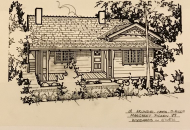
Drawing - Architectural drawing, 18 Arundel Crescent, Surrey Hills by Margaret Picken, 1989, 1989
Margaret Picken (1950-) trained and worked as a cartographic draftsman from 1968-1975 within the mining industry. These skills were readily transferable to work as a property illustrator for the real estate industry. Process: “Sketches were ordered by phone initially as there were no mobile phones or computers then. I would take our 2 year-old son with me to the houses when the other 2 boys were at school. I photographed houses with a Polaroid camera and made a ‘thumbnail’ sketch while there. The photos were used to scale off a sketch in pencil and then that sketch was overlaid with drafting film and the ‘pen and ink’ was completed. This process was the only one I used the entire time. Polaroid photos gave an instant usable photo. I then delivered the sketches by hand to the offices. There were deadlines each week on a Tuesday.” “… about 2003 coloured photos began to take over the sketches and mainstream companies replaced sole traders like myself providing a one-stop shop for all advertising. I produced my last Real Estate sketches in late 2005.” Margaret Picken (1950-) trained and worked as a cartographic draftsman from 1968-1975 within the mining industry. These skills were readily transferable to work as a property illustrator for the real estate industry. This architectural drawing is one of a series created by Margaret Picken for a range of real estate agents in Melbourne between c.1983 and 2005. Each work is signed and dated. Margaret Picken approached a number of historical societies in July 2020 with a view to donating her work. Sketches for post code 3127 are held by this collection. Others for suburbs including Ashburton, Balwyn, Camberwell, Canterbury, Blackburn, Box Hill, Burwood, Glen Iris, Hawthorn, Kew, Mont Albert North and Nunawading have been donated to the relevant historical group in those suburbs. (See Balwyn Historical Society, Box Hill Historical Society, Camberwell Historical Society, Hawthorn Historical Society, Kew Historical Society, Whitehorse Historical Society). In some cases, this collection also has a copy of the matching newspaper advertisement. Pen and ink architectural drawing on drafting film of 18 Arundel Crescent, Surrey Hills (VIC) by Margaret Picken. The drawing, dated 1989 , was commissioned by the Woodards real estate company.18 ARUNDEL CRES. S. HILLS / MARGARET PICKEN '89 / WOODARDS ~ C'WELLarchitectural drawing, houses, surrey hills / mont albert (vic.), artists, margaret picken 1950-, californian bungalow, arundel crescent -
 Surrey Hills Historical Society Collection
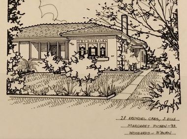
Drawing - Architectural drawing, 28 Arundel Crescent, Surrey Hills by Margaret Picken, 1993, 1989
Margaret Picken (1950-) trained and worked as a cartographic draftsman from 1968-1975 within the mining industry. These skills were readily transferable to work as a property illustrator for the real estate industry. Process: “Sketches were ordered by phone initially as there were no mobile phones or computers then. I would take our 2 year-old son with me to the houses when the other 2 boys were at school. I photographed houses with a Polaroid camera and made a ‘thumbnail’ sketch while there. The photos were used to scale off a sketch in pencil and then that sketch was overlaid with drafting film and the ‘pen and ink’ was completed. This process was the only one I used the entire time. Polaroid photos gave an instant usable photo. I then delivered the sketches by hand to the offices. There were deadlines each week on a Tuesday.” “… about 2003 coloured photos began to take over the sketches and mainstream companies replaced sole traders like myself providing a one-stop shop for all advertising. I produced my last Real Estate sketches in late 2005.” Margaret Picken (1950-) trained and worked as a cartographic draftsman from 1968-1975 within the mining industry. These skills were readily transferable to work as a property illustrator for the real estate industry. This architectural drawing is one of a series created by Margaret Picken for a range of real estate agents in Melbourne between c.1983 and 2005. Each work is signed and dated. Margaret Picken approached a number of historical societies in July 2020 with a view to donating her work. Sketches for post code 3127 are held by this collection. Others for suburbs including Ashburton, Balwyn, Camberwell, Canterbury, Blackburn, Box Hill, Burwood, Glen Iris, Hawthorn, Kew, Mont Albert North and Nunawading have been donated to the relevant historical group in those suburbs. (See Balwyn Historical Society, Box Hill Historical Society, Camberwell Historical Society, Hawthorn Historical Society, Kew Historical Society, Whitehorse Historical Society). In some cases, this collection also has a copy of the matching newspaper advertisement. Pen and ink architectural drawing on drafting film of 28 Arundel Crescent, Surrey Hills (VIC) by Margaret Picken. The drawing, dated 1993, was commissioned by the Woodards real estate company.28 ARUNDEL CRES, S. HILLS / MARGARET PICKEN ~ 93 / WOODARDSarchitectural drawing, houses, surrey hills / mont albert (vic.), artists, margaret picken 1950-, arundel crescent, 1940 -
 Surrey Hills Historical Society Collection
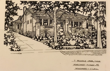
Drawing - Architectural drawing, Margaret Picken, 7 Arundel Crescent, Surrey Hills by Margaret Picken, 1995, 1995
Margaret Picken (1950-) trained and worked as a cartographic draftsman from 1968-1975 within the mining industry. These skills were readily transferable to work as a property illustrator for the real estate industry. Process: “Sketches were ordered by phone initially as there were no mobile phones or computers then. I would take our 2 year-old son with me to the houses when the other 2 boys were at school. I photographed houses with a Polaroid camera and made a ‘thumbnail’ sketch while there. The photos were used to scale off a sketch in pencil and then that sketch was overlaid with drafting film and the ‘pen and ink’ was completed. This process was the only one I used the entire time. Polaroid photos gave an instant usable photo. I then delivered the sketches by hand to the offices. There were deadlines each week on a Tuesday.” “… about 2003 coloured photos began to take over the sketches and mainstream companies replaced sole traders like myself providing a one-stop shop for all advertising. I produced my last Real Estate sketches in late 2005.” Margaret Picken (1950-) trained and worked as a cartographic draftsman from 1968-1975 within the mining industry. These skills were readily transferable to work as a property illustrator for the real estate industry. This architectural drawing is one of a series created by Margaret Picken for a range of real estate agents in Melbourne between c.1983 and 2005. Each work is signed and dated. Margaret Picken approached a number of historical societies in July 2020 with a view to donating her work. Sketches for post code 3127 are held by this collection. Others for suburbs including Ashburton, Balwyn, Camberwell, Canterbury, Blackburn, Box Hill, Burwood, Glen Iris, Hawthorn, Kew, Mont Albert North and Nunawading have been donated to the relevant historical group in those suburbs. (See Balwyn Historical Society, Box Hill Historical Society, Camberwell Historical Society, Hawthorn Historical Society, Kew Historical Society, Whitehorse Historical Society). In some cases, this collection also has a copy of the matching newspaper advertisement. Pen and ink architectural drawing on drafting film of 7 Arundel Crescent, Surrey Hills (VIC) by Margaret Picken. The drawing, dated 1995, was commissioned by the Woodards real estate company.7 ARUNDEL CRES., S. HILLS / MARGARET PICKEN ~ 95 / WOODARDS ~ C'WELLarchitectural drawing, houses, surrey hills / mont albert (vic.), artists, margaret picken 1950-, californian bungalow, arundel crescent -
 Bendigo Military Museum
Photograph - A Section, 1st Topographic Survey Troop, Nui Dat, Vietnam, 1969
This is a photograph of A Section, 1st Topographic Survey Troop taken at Nui Dat, Vietnam in 1969. A nominal roll of personnel and their trade as of the 30th of September 1969, accompanies this photo. Their trades in this photo were as follows - Surveyors Topographic: WO1 Darby Munro, SGT Paddy Strunks, SGT Graeme Birrell, CPL Brian Knight, CPL Colin Laybutt, SPR Roderick Gilbert and SPR Rodney Offer. Draughtsmen Topographic: SGT Terrance Linz, CPL Robert Kay, SPR Peter Aukstinaitis, SPR Lloyd Patterson and SPR Ian Wark. Photographer Cartographic: CPL George Graham. Clerk Admin: CPL Oreste Biziak. Helioworker: CPL Geoffrey White, SPR Lance Percey. Cook AACC: PTE R. Johnston. The first Royal Australian Survey Corps troops arrived in South Vietnam on the 10th of June 1966. This was a detachment from 1st Topographic Survey Troop, which was to give cartographic support to the Australian Task Force. Their main tasks were to establish a Theatre Grid, map compilation and map revision. Engineer Survey Support in the camp and to the civil community and give assistance to the Cordon Search Missions by producing large scale plots from aerial photos with every house and fence etc plotted and then reproduce these by silk screening usually, within a 24-hour period. This support concluded with the withdrawal of Australian troops from Vietnam in 1972. For more information on the career of A Section’s OC MAJ Peter Constantine AM, refer to item 6159P or 6092P. He was the CO of the Army Survey Regiment from 1975 to 1976 and CO of the School of Military Survey (SMS) from 1976 to his retirement in January 1982. His memoirs of active duty in Vietnam ‘Surveyor - Printer Behind the Lines’ was published in 2022. 2IC CAPT Frank Thorogood SB St J’s career culminated at the rank of LTCOL as the CO Army Survey Regiment from 1980 to 1981. More information on the A Section, 1st Topographic Survey Troop and the Army Survey Regiment’s supporting role is provided in pages 89 to 94 of Valerie Lovejoy’s book 'Mapmakers of Fortuna – A history of the Army Survey Regiment’ ISBN: 0-646-42120-4.This is a photograph of A Section, 1st Topographic Survey Troop taken at Nui Dat, Vietnam in 1969. The black and white photograph was printed on photographic paper and is part of the Army Survey Regiment’s Collection. The photograph was scanned at 300 dpi. .1) - Photo, black & white, 1969. Back row L to R: SPR Lance Percey, SPR Bruce Grisdale, SPR Rodney Offer, SPR Roderick Gilbert, CPL Geoffrey White, PTE R. Johnston, CPL Colin Laybutt, SPR Lloyd Patterson. Centre row L to R: SPR Peter Aukstinaitis, SPR Ian Hanna, SPR Ian Wark, CPL Robert Kay, CPL George Graham, CPL Oreste Biziak, CPL Brian Knight. Front row L to R: SGT Terrance Linz, SSGT Gordon Haswell, 2IC CAPT Frank Thorogood SB St J, OC MAJ Peter Constantine AM, WO1 Darby Munro, SGT Paddy Strunks, SGT Graeme Birrell.An A4 nominal roll of personnel and their trade accompanies the photo, as of the 30th of September 1969. A torn paper identifies the personnel in the photo. Annotated on back of photo – ‘Unit Photo – 1 Topo Svy Tp 30 Sept 69’royal australian survey corps, rasvy, army survey regiment, army svy regt, fortuna, asr -
 Bendigo Military Museum
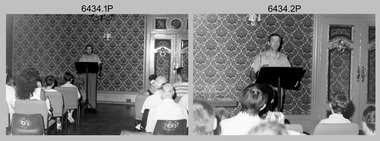
Photograph - Army Survey Regiment Open Day - Briefings and Tours, Fortuna, Bendigo, 1990
These 27 photographs were taken at an Army Survey Regiment Open Day at Fortuna Villa, Bendigo on the 24th of February 1990. This occasion was one of several events held to commemorate the 75th anniversary of the formation of the Royal Australian Survey Corps. Although historical tours of Fortuna occurred on a regular basis, this was the first technical open day since 1972. The Royal Australian Survey Corps recognised that an Open Day was the best way for the local community in Bendigo to gain an insight into the unit’s important role as Defence’s map production agency, its technical equipment, and its economic importance to Bendigo. It also gave them an opportunity to tour through historic Fortuna Villa. This occasion is covered in more detail in page 143 of Valerie Lovejoy’s book 'Mapmakers of Fortuna – A history of the Army Survey Regiment’ ISBN: 0-646-42120-4. Refer to items 6435.35P and 6436.18P for more photos of the Open Day taken in the Map Production areas of Air Survey and Cartographic Squadron, and production areas of Lithographic Squadron. Photo prints of some of these photos were scanned and catalogued in items 6247.30P and 6291.6P.These 27 photographs were taken at an Army Survey Regiment Open Day held at Fortuna, Bendigo on the 24th of February 1990. The 35mm colour and black & white negatives photographs were scanned at 96 dpi and are part of the Army Survey Regiment’s Collection. .1) & .2) - Photo, black & white, 1990. Ballroom - Visitor briefings by CO LTCOL Rene van den Tol. .3) - Photo, colour, 1990. Ballroom - Visitor briefings by MAJ Ray Redman. .4) - Photo, colour, 1990. Ballroom - Visitor briefings by unidentified UK Exchange officer. .5) - Photo, black & white, 1990. Music Room - Visitor briefings by MAJ Bob Williams. .6) - Photo, black & white, 1990. Orderly Room - ADJT CAPT Peter Parkes. .7) - Photo, colour, 1990. Music Room - ADJT CAPT Peter Parkes with civilian visitors. .8) - Photo, colour, 1990. Music Room - Visitor briefings by CPL Le-Anne (Smallshaw) Shirley. .9) - Photo, colour, 1990. Entrance Foyer - Visitor briefings. .10) - Photo, colour, 1990. CO’s Office - Visitor briefings by CPL Raelene (Munting) Brodie. .11) - Photo, colour, 1990. Mr Pat Thwaites outlining utilisation of satellite imagery to civilian visitors. .12) - Photo, black & white, 1990. Mr Pat Thwaites outlining utilisation of satellite imagery to civilian visitors. .13) - Photo, colour, 1990. Staircase leading up to the top floor - Visitor briefings by CPL Ian Nelson. .14) - Photo, colour, 1990. Building 16 - Visitor briefings by RSM WO1 Neville Stone. .15) - Photo, colour, 1990. Civilian visitors enjoying views of the garden from Fortuna Villa’s rooftop. .16) - Photo, black & white, 1990. Visitor briefings at Fortuna’s rear steps. .17) - Photo, black & white, 1990. Outside Building 16 - Visitor briefings by WO1 Gary Warnest. .18) - Photo, colour, 1990. Outside Building 16 - Visitor briefings by WO2 Adrian ‘Charlie’ Creedy. .19) - Photo, colour, 1990. Outside Building 16 - L to R: SPR Sue (Foote) Bourne, LCPL Sandy Winn, WO2 Adrian ‘Charlie’ Creedy. .20) - Photo, colour, 1990. Outside Building 16 - SGT Greg Byers. .21) - Photo, colour, 1990. Visitors enjoying Devonshire Tea in the gardens next to the Tavern. .22) - Photo, colour, 1990. RSM WO1 Neville Stone and family enjoying Devonshire Tea in the gardens next to the Tavern. .23) - Photo, colour, 1990. Visitors relaxing in the garden next to Fortuna’s lake. .24) - Photo, black & white, 1990. CPL Trevor Poll and others serve up BBQ lunch next to the tennis courts. .25) to .27) - Photo, colour, 1990. Parking at a premium inside the Army Survey Regiment and Chum Street..1P to .27P – no annotationsroyal australian survey corps, rasvy, army survey regiment, army svy regt, fortuna, asr -
 Bendigo Military Museum
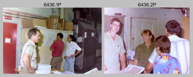
Photograph - Army Survey Regiment Open Day – Lithographic Squadron, Fortuna, Bendigo, 1990
These 18 photographs were taken at an Army Survey Regiment Open Day at Fortuna Villa, Bendigo on the 24th of February 1990. This occasion was one of several events held to commemorate the 75th anniversary of the formation of the Royal Australian Survey Corps. Although historical tours of Fortuna occurred on a regular basis, this was the first technical open day since 1972. The Royal Australian Survey Corps recognised that an Open Day was the best way for the local community in Bendigo to gain an insight into the unit’s important role as Defence’s map production agency, its technical equipment, and its economic importance to Bendigo. It also gave them an opportunity to tour through historic Fortuna Villa. This occasion is covered in more detail in page 143 of Valerie Lovejoy’s book 'Mapmakers of Fortuna – A history of the Army Survey Regiment’ ISBN: 0-646-42120-4. Refer to items 6434.27P and 6435.35P for more photos of the Open Day taken inside Fortuna, the garden areas and Map Production areas of Air Survey and Cartographic Squadron. Photo prints of some of these photos were scanned and catalogued in items 6247.30P and 6291.6P.These 18 photographs were taken at an Army Survey Regiment Open Day held at Fortuna, Bendigo on the 24th of February 1990. The 35mm colour and black & white negatives photographs were scanned at 96 dpi and are part of the Army Survey Regiment’s Collection. .1) - Photo, colour, 1990. Print Troop – WO2 Rob Bogumil with visitors. .2) - Photo, colour, 1990. Print Troop – L to R: SPR Ross Anza, LCPL Janet Murray with visitors. .3) - Photo, black & white, 1990. Print Troop – L to R: LCPL Janet Murray, MAJ Bob Coote, SPR Gary Lord with visitors. .4) - Photo, black & white, 1990. Photo Troop – L to R: WO2 Keith Fenton RE UK Exchange, SGT Steve Burke with visitors. .5) - Photo, colour, 1990. Photo Troop – SGT Steve Burke with visitors. .6) - Photo, colour, 1990. Photo Troop – L to R: unidentified, SGT Steve Burke with visitors. .7) - Photo, colour, 1990. Print Troop – L to R: CPL Peter Breukel, WO2 Keith Fenton RE. UK Exchange with visitors. .8) - Photo, black & white, 1990. Photo Troop - WO2 Keith Fenton RE. UK Exchange. .9) - Photo, black & white, 1990. Print Troop - civilian visitors. .10) - black & white, Print Troop, 1990. - L to R: civilian visitors, SSGT Ian Nichols, CPL John ‘Flash’ Anderson. .11) - Photo, black & white, 1990. Print Troop - L to R: SSGT Ian Nichols, CPL Dale Hudson, Planeta printing press, with civilian visitors. .12) - Photo, colour, 1990. Print Troop - L to R: SSGT Ian Nichols, CAPT Roger Hancock with civilian visitors. .13) - Photo, colour, 1990. Print Troop - LT Marty Lyons with civilian visitors. .14) - Photo, black & white, 1990. Print Troop - L to R: LT Marty Lyons, unidentified with civilian visitors. .15) - Photo, black & white, 1990. Orthophoto Mapping Section - L to R: SSGT Peter Imeson, SGT Bob Garritty with civilian visitors. .16) - Photo, colour, 1990. Optronics raster scanner - WO2 Adrian ‘Charlie’ Creedy with civilian visitors. .17) - Photo, colour 1990. Outside Photo Troop office - L to R: SSGT Rhys De Laine, WO2 Rob Bogumil. .18) - Photo, black & white, 1990. Photo Troop - civilian visitors..1P to .18P – no annotationsroyal australian survey corps, rasvy, army survey regiment, army svy regt, fortuna, asr, litho sqn -
 Bendigo Military Museum
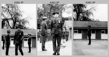
Photograph - Commanding Officer’s Parade at the Army Survey Regiment, Fortuna Villa, Bendigo, c1977
This is a set of 11 photographs of a Commanding Officer’s (CO’s) Parade held at the Army Survey Regiment, Bendigo in circa 1977. Key appointments at the time were LTCOL Bob Skitch, the Commanding Officer from 1976 to 1980 and WO1 Aub Harvey, the RSM of the unit from 1976 to 1982. The dates on the cover sheet are incorrect as female personnel appear in the summer uniform that was superseded in early 1979.This is a set of 11 photographs of a Commanding Officer’s (CO’s) Parade held at the Army Survey Regiment, Bendigo in circa 1977. The photographs were printed on photographic paper and are part of the Army Survey Regiment’s Collection. The black and white photographs were scanned at 300 dpi. .1) - Photo, Black & white, c1977. Air Survey Squadron L to R: WO1 Bob Mason, PTE CPL Marrianne (Van De Zee) De Groot, PTE Julia (Spark) Fitts, CPL Greg Gilbert, unidentified (x2), SGT Bruce Gordon, remainder unidentified. WO1 Graeme Birrell on far right. .2) & .3) - Photo, Black & white, c1977. Air Survey Squadron L to R: SPR Bob Clisby, CPL Alan Staley, unidentified, CPL John Smith, unidentified, CPL Phil McGuire, CPL Peter Mustart, SPR Gary Ames, WO1 Bob Mason – in foreground, unidentified, PTE Julia (Spark) Fitts, unidentified (x2), PTE CPL Marrianne (Van De Zee) De Groot, unidentified (x2), CPL Greg Gilbert, SGT Bruce Gordon. .4) - Photo, Black & white, c1977. Headquarter Squadron L to R: WO2 Max Neil, WO1 Alex Cairney, unidentified, SSGT Pat Lumsden, unidentified (x2), CPL Eddie Jacobs, unidentified (x3), SSGT Alan Strain, CPL Jim Cook. .5) - Photo, Black & white, c1977. Lithographic Squadron L to R: WO1 Tibby Szentirmay BEM, SSGT Jeff Lynch, unidentified, WO1 Fred Panknin, unidentified, SPR Mick ‘Buddha’ Ellis, unidentified, CPL Warren ‘Waldo’ Shirley, CPL John ‘Flash’ Anderson, SGT Trevor Osborne, unidentified, SPR Keith Quinton, unidentified, CPL Bill Jones, unidentified, PTE Janet (Chopping) Justin, WO2 Tom Pattison, SGT Gavin Neilson, SGT Graeme Jeffers, SGT Jeff Willey, SGT Greg Francis-Wright. .6) - Photo, Black & white, c1977. Cartographic Squadron – unidentified personnel. .7) - Photo, Black & white, c1977. Lithographic Squadron – unidentified personnel. .8) - Photo, Black & white, c1977. L to R: WO2 Tom Pattison, RSM WO1 Aub Harvey – facing camera, unidentified (x3), CO LTCOL Bob Skitch facing away receiving salute, remainder unidentified. .9) - Photo, Black & white, c1977. L to R: CAPT Graham Baker, unidentified, CO LTCOL Bob Skitch facing away, unidentified (x3), RSM WO1 Aub Harvey taking notes, unidentified. .10) - Photo, Black & white, c1977. Cartographic Squadron L to R: CO LTCOL Bob Skitch facing away receiving salute, unidentified, MAJ Robin Wilson, unidentified, RSM WO1 Aub Harvey, unidentified. .11) - Photo, Black & white, c1977. Lithographic Squadron undergoing inspection. WO1 Marj Knight at far left..1P to .11P – There are no personnel identified. “Parade 1979 or 1980” annotated on the cover sheet. Note – Dates are probably incorrect.royal australian survey corps, rasvy, army survey regiment, army svy regt, fortuna -
 Bendigo Historical Society Inc.
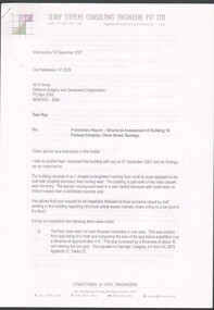
Document - Preliminary report of Structural assessment Fortuna
Fortuna Villa was initially commenced as a modest single storey home in 1861 next to the 180 Mine by Theodore Ballerstedt, who sold the mine and house to George Lansell in 1869. Lansell already owned the adjacent Fortuna Mine, and through deeper mining techniques greatly expanded the mine's operation, his personal wealth, and the house and grounds. Lansell was soon known as the 'Quartz King', Australia's first gold mining millionaire and credited as the driving force behind much of Bendigo's prosperity. He continuously added to and expanded the villa, decorating it extravagantly with the finest of artworks and materials, into a sprawling mansion with extensive landscaped grounds, to create a house and grounds of a size and grandeur with few rivals in Australia. After his death in 1907, his second wife Edith carried on with improvements, creating a house and grounds developed over 50 years. The attached mine also contributes to its significance, being one of the richest mines in Bendigo, and at one stage probably the deepest gold mine in the world at 3176 feet. The 1875 crushing works are attached directly to the mansion, and the mine's tailings and settling ponds (turned into ornamental lakes) represent a direct link between George Lansell's wealth and its source. Fortuna was compulsorily acquired by the Commonwealth in 1942 as the Cartographic Headquarters of the Australian Survey Corps during World War II, and many ancillary structures were added while preserving the main house and ornamental grounds. Victorian Heritage Database Report https://vhd.heritagecouncil.vic.gov.au/places/68334/download-reportPreliminary report of Structural assessment of Building 16 Fortuna Complex, Chum Street, Bendigo. Four page preliminary report finding the building is structurally safe as at Wed 19 December 2007 with three recommendations. Prepared for DIGO by Structural Engineers - Terry Stevens Consulting Engineers Pty Ltd.fortuna, structural assessment -
 Bendigo Historical Society Inc.
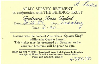
Ephemera - Tour Ticket
Fortuna Villa was initially commenced as a modest single storey home in 1861 next to the 180 Mine by Theodore Ballerstedt, who sold the mine and house to George Lansell in 1869. Lansell already owned the adjacent Fortuna Mine, and through deeper mining techniques greatly expanded the mine's operation, his personal wealth, and the house and grounds. Lansell was soon known as the 'Quartz King', Australia's first gold mining millionaire and credited as the driving force behind much of Bendigo's prosperity. He continuously added to and expanded the villa, decorating it extravagantly with the finest of artworks and materials, into a sprawling mansion with extensive landscaped grounds, to create a house and grounds of a size and grandeur with few rivals in Australia. After his death in 1907, his second wife Edith carried on with improvements, creating a house and grounds developed over 50 years. The attached mine also contributes to its significance, being one of the richest mines in Bendigo, and at one stage probably the deepest gold mine in the world at 3176 feet. The 1875 crushing works are attached directly to the mansion, and the mine's tailings and settling ponds (turned into ornamental lakes) represent a direct link between George Lansell's wealth and its source. Fortuna was compulsorily acquired by the Commonwealth in 1942 as the Cartographic Headquarters of the Australian Survey Corps during World War II, and many ancillary structures were added while preserving the main house and ornamental grounds. Victorian Heritage Database Report https://vhd.heritagecouncil.vic.gov.au/places/68334/download-reportTicket for Fortuna Villa Tour conducted by the Army Survey Regiment and the National Trust. 31/12/1985. Black printing on yellow card.fortuna villa, tour -
 Bendigo Historical Society Inc.
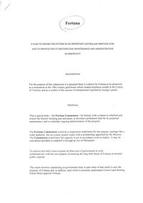
Document - Preservation proposal
Fortuna Villa was initially commenced as a modest single storey home in 1861 next to the 180 Mine by Theodore Ballerstedt, who sold the mine and house to George Lansell in 1869. Lansell already owned the adjacent Fortuna Mine, and through deeper mining techniques greatly expanded the mine's operation, his personal wealth, and the house and grounds. Lansell was soon known as the 'Quartz King', Australia's first gold mining millionaire and credited as the driving force behind much of Bendigo's prosperity. He continuously added to and expanded the villa, decorating it extravagantly with the finest of artworks and materials, into a sprawling mansion with extensive landscaped grounds, to create a house and grounds of a size and grandeur with few rivals in Australia. After his death in 1907, his second wife Edith carried on with improvements, creating a house and grounds developed over 50 years. The attached mine also contributes to its significance, being one of the richest mines in Bendigo, and at one stage probably the deepest gold mine in the world at 3176 feet. The 1875 crushing works are attached directly to the mansion, and the mine's tailings and settling ponds (turned into ornamental lakes) represent a direct link between George Lansell's wealth and its source. Fortuna was compulsorily acquired by the Commonwealth in 1942 as the Cartographic Headquarters of the Australian Survey Corps during World War II, and many ancillary structures were added while preserving the main house and ornamental grounds. Victorian Heritage Database Report https://vhd.heritagecouncil.vic.gov.au/places/68334/download-reportProposal for the formation of a Fortuna Commission to ensure the preservation of Fortuna Villa. Written by Daryl McClure. May 2012fortuna villa, preservation, daryl mcclure -
 Bendigo Historical Society Inc.
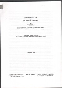
Document - Pompeii Fountain & Adjacent Structures at "Fortuna"
Fortuna Villa was initially commenced as a modest single storey home in 1861 next to the 180 Mine by Theodore Ballerstedt, who sold the mine and house to George Lansell in 1869. Lansell already owned the adjacent Fortuna Mine, and through deeper mining techniques greatly expanded the mine's operation, his personal wealth, and the house and grounds. Lansell was soon known as the 'Quartz King', Australia's first gold mining millionaire and credited as the driving force behind much of Bendigo's prosperity. He continuously added to and expanded the villa, decorating it extravagantly with the finest of artworks and materials, into a sprawling mansion with extensive landscaped grounds, to create a house and grounds of a size and grandeur with few rivals in Australia. After his death in 1907, his second wife Edith carried on with improvements, creating a house and grounds developed over 50 years. The attached mine also contributes to its significance, being one of the richest mines in Bendigo, and at one stage probably the deepest gold mine in the world at 3176 feet. The 1875 crushing works are attached directly to the mansion, and the mine's tailings and settling ponds (turned into ornamental lakes) represent a direct link between George Lansell's wealth and its source. Fortuna was compulsorily acquired by the Commonwealth in 1942 as the Cartographic Headquarters of the Australian Survey Corps during World War II, and many ancillary structures were added while preserving the main house and ornamental grounds. Victorian Heritage Database Report https://vhd.heritagecouncil.vic.gov.au/places/68334/download-reportConservation report for the Pompeii Fountain & Adjacent Structures at "Fortuna" Chum Street, Golden Square, Victoria. Prepared for Fortuna Historical Committee. March 1996.Halina Eckersley, Architect & Conservation Planner, Kewpompeii fountain, greenhouse, fortuna lake, gardens -
 Bendigo Military Museum
Photograph - Photographic Technicians performing tasks at the Army Headquarters Survey Regiment, c1960s
These eight photographs were most likely taken in the 1960s in Lithographic Squadron at the Army Headquarters Survey Regiment, Fortuna, Bendigo. Although Photo .1P is not annotated the remainder have the name of the technicians written on the back. The equipment operated by the technicians is the KLIMCH Commodore camera. The main tasks undertaken by the technicians were most likely enlargements and reductions of map reproduction material. The KLIMSCH Commodore camera was introduced in 1953 and was the largest in the Southern Hemisphere. It was replaced with a new model of the same size in 1979. The new model with its computer-based interface provided productivity gains with improved speed and its consistent results led to less wastage in time and materials. Its variomat lens system provided improved retention of map feature linear weights during the camera reduction process. The typed description pasted on the back of photo .5P states “Cpl R. MacKenzie of Bentley, Perth (WA) of the AHQ Survey Regt, located at “Fortuna”, Bendigo, (Vic). Has been in the Army for 5 years. He removes the lens cap from the 70 inch F16 lens of the giant KLIMSCH camera used in map making for the Army. The camera which was specially made for the Army in Germany is fully automatic and power operated. It is claimed to be one of the biggest automatic cameras of its type in the world. It was made to the specifications of the Aust Army Survey Corps to assist in the production of the very high standard maps for the Army. The AHQ Survey Regt also assists Commonwealth and other Govt departments in the printing of maps required other than for Army needs. The KLIMSCH camera is used for cartographic mapping photography.” This is a set of photographs of technicians operating photographic reproduction equipment at the Army Headquarters Survey Regiment, Bendigo c1960s. The photographs were printed on photographic paper and are part of the Army Survey Regiment’s Collection. The photographs were scanned at 300 dpi. .1) - Photo, black & white, c1960s, Les ‘Snow’ Taylor, Lithographic Squadron .2) - Photo, black & white, c1960s, Les ‘Snow’ Taylor, Lithographic Squadron .3) - Photo, black & white, c1960s, John Rolfe, Lithographic Squadron .4) - Photo, black & white, c1960s, John Rolfe, Lithographic Squadron .5) - Photo, black & white, c1960s, CPL R. MacKenzie, Lithographic Squadron .6) - Photo, black & white, c1960s, unidentified, Lithographic Squadron .7) - Photo, black & white, c1960s, George Graham, Lithographic Squadron .8) - Photo, black & white, c1960s, L to R: Bill Snelson, George Graham, Lithographic Squadron.1P – no annotation .2 to .4 – personnel names (less rank) annotated on back. .5 – name and rank annotated on back, with detailed typed description .6 to .8 – personnel names (less rank) annotated on back. royal australian survey corps, rasvy, army survey regiment, army svy regt, fortuna, asr, litho -
 Flagstaff Hill Maritime Museum and Village
Document - Navigation Chart, Admiralty Office, Lady Bay and Warrnambool Harbour, 03/04/1871
This Chart titled “Lady Bay and Warrnambool Harbour” was surveyed by Nav. Lieut. H.J. Stanley, of Britain's Royal Navy, in 1870 and printed in April 1871. The chart was made before the Warrnambool Breakwater was built (construction had begun in 1874 and was completed in 1890). The chart includes Directions for entering Lady Bay, Warrnambool Harbour. These are "Vessels entering Warrnambool Harbour must bring the Red Light in sight and steer in with it in line with the upper white Light bearing North, until the Green Light on the Jetty is opened, when steer towards it and anchor. The best anchorage is in 2 ¼ fms [fathoms)] of water, about a cable from ledge off Breakwater rock. Or where convenient, according to draught of water, only endeavouring to anchor as close as possible to Breakwater rock. It is not safe to enter or leave the Harbour in south westerly or Southerly gales.” This chart is significant for its strong connection to the maritime history of Warrnambool Harbour and Lady Bay, and eventually to the Warrnambool Breakwater. The Warrnambool Breakwater is registered as a place of significance on the Victorian Heritage Database (VHR H2024). A copy of the same chart was used to plan several submissions for future changes to the jetty and breakwater. The chart is a historical record of structures existing in 1870; the Warrnambool Jetties, Lady Bay, the leading lights (lighthouses), streets, roads, bridges and many buildings. It also shows the lay of the land and seabed.Canvas chart of Australia, South Coast, Victoria Title: Lady Bay and Warrnambool Harbour Surveyed by Nav. Lieut. H.J. Stanley, R.N., 1870. Magnet Variation, 1870 Published April 3, 1871, by the Admiralty, London. Directions for vessels entering Warrnambool Harbour are printed on the chart. The chart has a lacquer or seal over it.Top of chart has logo "HYDROGRAPHER OFFICE" "Price Eighteen Pence". "Engraved by Edward Weller" Along bottom of Chart: “London… Published at the Admiralty, 3rd April 1871, under the Superintendence of Rear Admiral G.H. Richards, F.R.S. Hydrographer, Corrections July 71” Bottom of chart “Australia South Coast Victoria Lady Bay and Warrnambool Harbour. 2494”flagstaff hill, warrnambool, chart of lady bay warrnambool 1870, warrnambool harbour, cartography, navigation, warrnambool breakwater, 1871, australia – south coast / victoria, lady bay, 1870, nav. lieut. h.j. stanley, r.n, directions for entering warrnambool harbour, hydrographer office, rear admiral g.h. richards, edward weller, port of warrnambool, flagstaff hill maritime museum & village, maritime museum, maritime village, shipwreck coast, map, chart, navigation chart, admiralty chart, breakwater, jetty, pier, vhr h2024 -
 Bendigo Historical Society Inc.
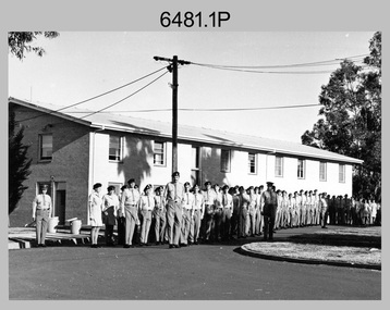
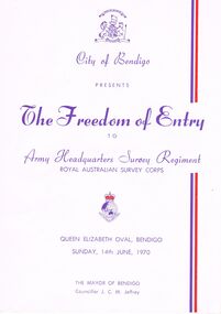
Document - THE FREEDOM OF ENTRY TO ARMY HEADQUARTERS SURVEY REGIMENT, QUEEN ELIZABETH OVAL, 14 June, 1970
The Freedom of Entry to Army Headquarters Survey Regiment Royal Australian Survey Corps, Queen Elizabeth Oval, Bendigo, Sunday, 14th June, 1970.The Mayor of Bendigo Councillor J C M Jeffrey. Presented by City of Bendigo. Photographs of the Mayor of Bendigo Councillor J C M Jeffrey, Colonel Commandant of the Regiment Brigadier D Macdonald and Commanding Officer Lt Col L B Sprenger, MBE. The City of Bendigo On the 14th day of June 1970 we extend to the Commanding Officer, Officers and Men of the A. H. Q. Survey Regiments Greetings Whereas the Bendigo City Council at a meeting held on the 20th day of April 1970 resolved unanimously that in appreciation of your loyal service to Our Sovereign Our Country and Our City and in recognition of the long and close association existing between the city and the Regiment in which so many of our citizens have been proud to serve, we hereby confer upon such Regiment by this Deed and in perpetuity the privilege honour and distinction of the Freedom of Entry into the City of Bendigo on Ceremonial Occasions in full panoply with Swords drown Bayonets fixed Drums beating Bands playing and Colours Flying. In Witness whereof the Common Seal of the Council was hereto affixed on the 14th day on June 1970 in the presence of J C M Jeffrey Mayor A J Watts Town Clerk. Order Of Ceremony Sunday, 14th June commencing at 1.45pm Bendigo Bands will play selections until 2.10pm, when Bands will move off the arena. The parade of Army Headquarters Survey Regiment Marches into the Queen Elizabeth Oval, Led by the Band of the Royal Australian Armoured Corps . . . Bendigo city council 1969-70 councillors listed . . . Officers Serving with Army Headquaters Survey Regiment on 14th June, 1970, listing . . . A Short History of the Regiment's Association with the City of Bendigo; 1942-1970. On 27th March, 1942, 'Fortuna' was occupied by LHQ Cartographic Company, Australian Survey Corps. . . . Commanding Officers of AHQ Survey Regiment. . . 11 pages.event, official, army survey regiment, the freedom of entry to army headquarters survey regiment royal australian survey corps, queen elizabeth oval, bendigo, sunday, 14th june, 1970.the mayor of bendigo councillor j c m jeffrey. presented by city of bendigo. photographs of the mayor of bendigo councillor j c m jeffrey, colonel commandant of the regiment brigadier d macdonald and commanding officer lt col l b sprenger, mbe. the city of bendigo on the 14th day of june 1970 commanding officer, officers and men of the a. h. q. survey regiments greetings bendigo city council at a meeting 1970 resolved unanimously that in appreciation of your loyal service to our sovereign our country and our city the freedom of entry into the city of bendigo on ceremonial occasions in full panoply with swords drown bayonets fixed drums beating bands playing and colours flying. order of ceremony sunday, 14th june commencing at bendigo bands bands. the parade of army headquarters survey regiment marches into the queen elizabeth oval, royal australian armoured corps . . . bendigo city council 1969-70 councillors listed . . . officers serving with army headquaters survey regiment on 14th june, 1970, listing . . . a short history of the regiment's association with the city of bendigo; 1942-1970. on 27th march, 1942, 'fortuna' was occupied by lhq cartographic company, australian survey corps. . . . commanding officers of ahq survey regiment -
 Bendigo Military Museum
Photograph - Army Survey Regiment – Corps Day Parade and Defence Force Service Medal Presentation, Fortuna Villa, Bendigo, 1986
This set of 39 photographs were taken at a Corps Day Parade held at the Army Survey Regiment, Bendigo in July 1986. The Parade Commander was CO LTCOL Don Swiney MBE, and the Reviewing Officer was the former CO of the Army Survey Regiment – LTCOL Don Ridge (Retd). The Corps Day Parade was held to commemorate the 71st anniversary of the formation of the Royal Australian Survey Corps. These photos comprise inspections of the Regiment’s four squadrons and the presentation of the Defence Force Service Medal in recognition of 15 years of efficient remunerated service to an unidentified Corporal.This is a set of 39 photographs of a Corps Day Parade held at the Army Survey Regiment, Fortuna, Bendigo in July 1986. The black & white photographs are on 35mm negative film and are part of the Army Survey Regiment’s Collection. The photographs were scanned at 96 dpi. .1) - Photo, black & white, July 1986. L to R: MAJ Rene van den Tol, CO LTCOL Don Swiney MBE, 2IC MAJ Kym Weston. .2) - Photo, black & white, July 1986. L to R: Unidentified Officer, 2IC MAJ Kym Weston. .3) - Photo, black & white, July 1986. L to R: Unidentified Officers, CO LTCOL Don Swiney MBE. .4) - Photo, black & white, July 1986. L to R: Unidentified Officers, CO LTCOL Don Swiney MBE. .6) - Photo, black & white, July 1986. L to R: Reviewing Officer’s wife, Mrs Ruth Ridge, CO LTCOL Don Swiney MBE. .7) - Photo, black & white, July 1986. L to R: Reviewing Officer’s wife, Mrs Ruth Ridge, unidentified, Reviewing Officer - LTCOL Don Ridge (Retd), CO LTCOL Don Swiney MBE, CPL John Gilbert. .8) & .9) - Photo, black & white, July 1986. L to R: Reviewing Officer - LTCOL Don Ridge (Retd) and CO LTCOL Don Swiney MBE exchange salutes. .10) - Photo, black & white, July 1986. Army Survey Regiment personnel formed up on parade ground. .11) - Photo, black & white, July 1986. Air Survey Squadron formed up on parade ground. OC MAJ Daryl Hockings at far left, unidentified officer, front rank left marker SSGT Graham Ragless, centre rank left marker SSGT Adrian ‘Charlie’ Creedy, rear rank L to R: CPL Nick Van Dalen, CPL Andy Lucas, SSGT Doug Gay, left marker SSGT Denis McCarthy, WO2 Brian Partridge on far right. .12) - Photo, black & white, July 1986. Lithographic Squadron formed up on parade ground. L to R: OC MAJ Mick Byrne, WO2 Ralph Chant. Front rank L to R: Unidentified (x10), CPL Roy Hicks, CPL Brian Fauth. Front rank L to R: Unidentified personnel, CPL Brian Paul, unidentified. Rear rank L to R: Unidentified personnel, CPL Lance Strudwick, SGT Graham Johnston. WO2 Kevin McQuire at far right. .13) - Photo, black & white, July 1986. Air Survey Squadron formed up on parade ground. unidentified officer, rear rank right marker CPL Brian Johnson, centre rank right marker SPR Brett Parkin, front rank right marker unidentified, remaining personnel unidentified, CAPT Peter Cates, OC MAJ Daryl Hockings at far right. .14) to .16) - Photo, black & white, July 1986. Reviewing Officer - LTCOL Don Ridge (Retd) delivers his Corps Day Address. 2IC MAJ Kym Weston facing the dais, CO LTCOL Don Swiney MBE at far right. .17) & .18) - Photo, black & white, July 1986. Army Survey Regiment headed by 2IC MAJ Kym Weston salutes whilst passing the dais, with RSM WO1 Jeff Lynch on his right. Air Survey Squadron led by MAJ Daryl Hockings. CO LTCOL Don Swiney MBE and Reviewing Officer - LTCOL Don Ridge (Retd) at far right. .19) & .20) - Photo, black & white, July 1986. Lithographic Squadron led by OC MAJ Mick Byrne and LT Ross Jenkins. First rank L to R: Brian Fauth, unidentified, SGT Graham Johnston. Remainder not identified. CO LTCOL Don Swiney MBE and Reviewing Officer - LTCOL Don Ridge (Retd) at far right. .21) & .22) - Photo, black & white, July 1986. Headquarters Squadron Squadron led by unidentified OC. CAPT Don Maskew on his right. CAPT John South on his left. Left file L to R: unidentified, SGt Kevin Boehm, unidentified, CPL John ‘JJ’ Smith, remainder unidentified. CO LTCOL Don Swiney MBE and Reviewing Officer - LTCOL Don Ridge (Retd) at far right. .23) & .24) - Photo, black & white, July 1986. Cartographic Squadron led by OC MAJ Bob McHenry. Officers rank L to R: LT Vicky Thompson, CAPT Roger Rix, CAPT Peter ‘Blue’ Blaskett. SPR Ben Lucas in background behind CAPT Rix. Left file L to R: CPL Ian Bowes, SGT Stuart Hibbert, SGT Mal Paterson, remainder unidentified. CO LTCOL Don Swiney MBE and Reviewing Officer - LTCOL Don Ridge (Retd) at far right. .25) - Photo, black & white, July 1986. Air Survey Squadron awaiting inspection. L to R: unidentified officer, front rank left marker SSGT Graham Ragless, centre rank left marker SSGT Adrian ‘Charlie’ Creedy, rear rank L to R: CPL Nick Van Dalen, CPL Andy Lucas, SSGT Doug Gay, left marker SSGT Denis McCarthy, WO2 Brian Partridge on far right. .26) - Photo, black & white, July 1986. Air Survey Squadron inspection by Reviewing Officer - LTCOL Don Ridge (Retd) and CO LTCOL Don Swiney MBE. L to R: unidentified officer, front rank left marker SSGT Graham Ragless, centre rank left marker SSGT Adrian ‘Charlie’ Creedy, rear rank L to R: CPL Nick Van Dalen, CPL Andy Lucas, SSGT Doug Gay, left marker SSGT Denis McCarthy, WO2 Brian Partridge on far right. .27) - Photo, black & white, July 1986. Cartographic Squadron awaiting inspection. Officers rank L to R: CAPT Roger Rix, CAPT Peter ‘Blue’ Blaskett, LT Brenton McDonald. Remainder unidentified. .28) - Photo, black & white, July 1986. Lithographic Squadron inspection by Reviewing Officer - LTCOL Don Ridge (Retd) and CO LTCOL Don Swiney MBE. Warrant Officers rank L to R: WO2 Ralph Chant, WO1 George Austen, remainder unidentified. .29) - Photo, black & white, July 1986. Lithographic Squadron inspection by Reviewing Officer - LTCOL Don Ridge (Retd) and CO LTCOL Don Swiney MBE. Unidentified personnel. .30) - Photo, black & white, July 1986. Cartographic Squadron inspection by Reviewing Officer - LTCOL Don Ridge (Retd) and CO LTCOL Don Swiney MBE. Unidentified personnel. .31) - Photo, black & white, July 1986. Cartographic Squadron inspection by Reviewing Officer - LTCOL Don Ridge (Retd) and CO LTCOL Don Swiney MBE. LT Brenton McDonald on far left, remainder unidentified. .32) - Photo, black & white, July 1986. Air Survey Squadron inspection. Left marker SSGT Denis McCarthy, supernumerary rank: WO1 Dick Manley, unidentified and WO2 Brian Partridge on far right. .33) - Photo, black & white, July 1986. CO LTCOL Don Swiney MBE announcing a recipient of the Defence Force Service Medal, in recognition of 15 years of efficient remunerated service. .34) to .38) - Photo, black & white, July 1986. Former CO of the Army Survey Regiment – LTCOL Don Ridge (Retd) presents the Defence Force Service Medal to an unidentified recipient in recognition of 15 years of efficient remunerated service. CO LTCOL Don Swiney MBE in background. .39) - Photo, black & white, July 1986. The Reviewing Officer - LTCOL Don Ridge (Retd) departs the Corps Day Parade accompanied by CO LTCOL Don Swiney MBE..1P to .39P – There are no personnel identified.royal australian survey corps, rasvy, army survey regiment, army svy regt, fortuna, asr -
 Bendigo Military Museum
Photograph - Co-ordinatorgraph Map Grid Production, Army Survey Regiment, Fortuna Bendigo, c1960s to 1970s
This is a set of seven photographs of map grid production using co-ordinatorgraphs at the Army Survey Regiment, Fortuna Bendigo. c1960s to 1970s. The Aristo Co-ordinatorgraph introduced in 1962 was a large heavy steel framed light table with a scribing head that moved in a XY direction using a vernier calibrated measuring scale to 0.001 of an inch. Whilst hand operated it was much quicker and accurate than manual grid and graticule calculation, plotting and scribing. Mapping PNG presented the Regiment with many challenges. WO1 Farrington and CPL John Dean developed computer software for the digitally controlled co-ordinatorgraph, the Calcomp 718 Flatbed Plotter. Much time was saved by automatically plotted cartographic grids and graticules, and automatically draw base compilation sheets complete with aerial triangulated stereo model control. This could be used for a number of maps and was the first step towards map automation. The history of co-ordinatorgraphs is covered in more detail with additional historic photographs, in pages 50 to 51 and page 88 of Valerie Lovejoy’s book 'Mapmakers of Fortuna – A history of the Army Survey Regiment’ ISBN: 0-646-42120-4. SGT Bill Boyd appearing in photo .1P reach the rank of WO1 and for 11 years was the technical warrant officer at the Detachment Army Survey Regiment located at Bonegilla, Victoria. He was awarded the OAM, the Order of Australia Medal for the development of the Flexiflow quality control system. This system comprised a series of job plans and charts linked to a task allocation to resource magnetic planning board. Using critical path analysis and task prioritisation, complex job planning was efficiently scheduled, and re-prioritisations readily made. Reproduction requirements were effectively coordinated by way of weekly courier to the Army Survey Regiment. Supervisors and technicians fully embraced the system as they could understand their role, others around them and the positive production achievements. Bendigo. See page 178 of Valerie Lovejoy’s book for more information on WO1 Boyd’s contribution to RA Svy.This is a set of seven photographs of map grid production using co-ordinatorgraphs at the Army Survey Regiment, Fortuna Bendigo. c1960s to 1970s. The photographs were printed on photographic paper and are part of the Army Survey Regiment’s Collection. The photographs were scanned at 300 dpi. .1) - Photo, black & white, c1960s, L to R: SGT Bill Boyd demonstrating Aristo Co-ordinatorgraph equipment to unidentified technicians (x3) .2) - Photo, black & white, c1960s, Aristo Co-ordinatorgraph equipment. .3) - Photo, black & white, c1960s, unidentified technician operating Aristo Co-ordinatorgraph equipment. .4) - Photo, black & white, c1960s, L to R: PTE Desi Asaris and CPL Kalen Sargent operating Aristo Co-ordinatorgraph equipment. .5) - Photo, black & white, Photo, black & white, c1970s, John Bloor operating Calcomp co-ordinatorgraph equipment. .6) - Photo, black & white, Photo, black & white, c1970s, unidentified technician operating Calcomp co-ordinatorgraph equipment. .7) - Photo, black & white, Photo, black & white, c1970s, L to R: SGT Andy Covington and SGT John Waight operating Calcomp co-ordinatorgraph equipment..7P annotated on back ‘Covington & Waight’.royal australian survey corps, rasvy, army survey regiment, army svy regt, fortuna, asr, carto, air survey -
 Bendigo Military Museum
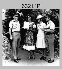
Photograph - Army Survey Regiment – Presentation to Charity Organisation, 1984
These photographs of a presentation to a charity organisation were taken in the grounds of Fortuna Villa, Army Survey Regiment in 1984. SPR Tracy (Parker) Ash was the unit’s Miss Golden North section entrant in the Miss Australia Quest. MAJ Bob Roche, RSM Bob Mason and SPR Parker presented a fundraising cheque to the unidentified representative from the Spastic Society. The the newspaper article is from the Bendigo Advertiser. The following wording is taken from the article: ‘Tracy Parker is a sapper in the Army, and a cartographic technician stationed at Fortuna, Bendigo. Originally from Melbourne, Tracy, 23, is the latest entrant in the Miss Golden North segment of the Miss Australia Quest. The highlight of Tracy’s quest will be an open day at Fortuna, once the magnificent home of Bendigo’s Quartz King, George Lansell. This open day at Fortuna, on Sunday, August 26, between 10 am and 4 pm, will give district residents a rare opportunity of inspecting this magnificent building and its gardens. Tracy said there will be handicrafts, rides, competitions and refreshments available at the open day. The main attraction, apart from the building and gardens, would be a hot air balloon. Admission to the open day would be: Adults $2, children and pensioners $1, family party $5. All proceeds from the open day at Fortuna will go to the Spastic Society. Tracy, like all other Miss Australia candidates work hard for the Spastic Society in fundraising activities. Getting further involved in fundraising, Tracy and her strong committee have organised a 6km fun run for Sunday August 19. Entry forms are available at Bendigo sports stores, and at the end of the fun run will be a barbecue. Apart from her vocation in the Army, and fundraising for the Spastic Society, Tracy Parker has a great love of horses, and associated activities of riding, jumping and showing her horses. Tracy is keen to do well in her fundraising, and with the Australian Army, or more particularly, the ranks of Fortuna behind her, Tracy looks like succeeding.’The first three items are photographs of a presentation to a charity organisation at the Army Survey Regiment, Bendigo in 1984. The fourth item is an article from the Bendigo Advertiser describing Army Survey Regiment’s fund-raising activities. The photographs were printed on photographic paper and are part of the Army Survey Regiment’s Collection. The photographic proof prints were scanned at 600 dpi. Photos .1P and .2P were scanned at 300 dpi. The newspaper article was scanned at 762 dpi. .1) to .3P) - Photo, black & white, 1984, L to R: MAJ Bob Roche, Regional Coordinator Mrs Jan Lamborn, SPR Tracy (Parker) Ash, RSM WO1 Bob Mason. .4) – Bendigo Advertiser newspaper article with photo, black & white, 1984, SPR Tracy (Parker) Ash. .1P to .2P – ‘Presentation of Certificate of Appreciation from Spastic Society. Presented by Regional Coordinator Mrs Jan Lamborn to MAJ Roche, SPR Tracy Ash (entrant in Miss Australia Quest (1984) and WO1 Mason.' .3P – No personnel identified. .4P – SPR Tracy Parker named in newspaper article.royal australian survey corps, rasvy, army survey regiment, army svy regt, fortuna, asr -
 Bendigo Military Museum
Map - Map Extract - Charterhouse of Mendip, John James Raisbeck, Unknown
Map extract showing the towns of Cheddar, Rodney Stoke, Westbury and a smaller town of Easton. The area depicted is part of Somerset, England. Map is hand drawn by J.J. Raisbeck date unknown. John James RAISBECK was born on 4 July 1880 at Christchurch New Zealand. He served 4 years (Citizen Military Force - CMF) in 9th Australian Light Horse Regiment in Central VIC with the rank 2nd Lieutenant. He was the first Australian appointed to the Survey Section RAE, on 16 April 1910, as a draughtsman which was his civilian profession, with the rank Warrant Officer, honorary 2nd Lieutenant. He was required to resign his commission in the CMF. He supervised the draughting work of the Section in Melbourne and was largely responsible for the mapping standards and specifications set in the production of the Cowes one-inch-to-one-mile military map, which became the enduring Australian standard. He was also responsible for supervising the printing of the maps by the Victorian Government Printer. He was appointed 2nd Lieutenant in the AIF Survey Corps draft on 6 December 1917 (from Melbourne) embarking for England on 22 December 17. He was attached to the Australian Corps Topographic Section in France from 21 April 1918 to 5 March 1919 serving as Second-in-Command and as Officer Commanding. He was promoted Lieutenant 15 October 1918, attending the AIF Survey School, Southampton in 1919, returning to Australia 23 June 1919, before his AIF appointment was terminated 17 July 1919. He went on to serve the Survey Section RAE and Australian Survey Corps, including in the Second World War, having been promoted Captain then Major and Officer Commanding Army Headquarters Cartographic Section until February 1940. He retired after 33 years of service to military survey, and after serving the Corps in two world wars, on 4 July 1943 with the retired rank Lieutenant-Colonel. He was the author of the article ‘A Short History of the Military Survey of Australia, 1907-1936’, published in The Australian Surveyor, Sept 1, 1937Map extract slightly larger than A4. Scale: One Inch to One and a half Mile. 1:31680, 9 x copiesSignature of "J.J. Raisbeck" bottom right-hand cornerroyal australian survey corps, rasvy, fortuna, army survey regiment, army svy regt, asr -
 Flagstaff Hill Maritime Museum and Village
Book - Textbook, Introduction to Modern Geography
This mid-19th century scientific reference book, Introduction to Modern Geography, explains geography and astronomy using the globe of the world as a teaching aid. The inscription connects this book to the Bobinawarrah Public Library but research to date has found no further details about the library. The rural area was settled in 1859, but in 2016 its population was only 87. It is situated about 21 kilometres south of the City of Wangaratta, in Northeast Victoria. In 2024 the local community received a grant for preservation of its almost 100-year-old Bobinawarrah Memorial Hall which displays an honour board of the Pioneers of Bobinawarrah 1859-1959. The donor of the book lived in Warrnambool. ABOUT THE AUTHOR, James Thomson (1786-1849): - James Thomson was a British Irish mathematician. He became Professor of Mathematics at the University of Glasgow. He wrote many school textbooks and reference books, one of which was Introduction to Modern Geography, first published in Belfast in 1827, and revised and published in over 20 more editions. Thomson tutored two of his several children at home. His older son James Thomson (1822-1892) became an engineer and physicist. His younger son William Thomson (1824-1907) became Professor of Natural Philosophy from 1846-1899 at the University of Glasgow, and later the 1st Baron of Kelvin, famous for his designs of nautical instruments such as the navigational compass and sounding equipment used in the transatlantic installation of sea cable. William was part of the firm that became famous as Kelvin & Hughes Ltd., suppliers of radar and echo sounders to the Ministry of Transport and the Ministry of Defence. The name continued on as Kelvin & Hughes. James Thomson (1786-1849) was a renowned British Irish mathematician and Professor of Mathematics at the University of Glasgow. He was a respected author of many important school books and textbooks that were widely used to provide understanding of arithmetic and geography. Thomson encouraged practical education and held extra classes for young ladies to learn mathematics and geography, which were a novelty at that time. Many of his works were known and used worldwide. This work was published in many editions. It is now considered as culturally significant as a basis for knowledge about our civilisation and has been made publicly available in overseas countries, and republished and reproduced in a readable format, including its diagrams and maps. Book; scientific textbook. The book has a black leather cover. The front cover is blank, but the spine has an embossed gold vertical title within a rectangular border boasting fancy corners. The fly page has a detailed title. The author is James Thomson. It is the Eighteenth edition, published in Simms & McIntyre of London and Belfast in 1845. An inscription connects it to the Bobinawarrah Public Library in Victoria.Spine within a gold border: "THOMSON'S GEOGRAPHY" Fly Page: "AN INTRODUCTION TO MODERN GEOGRAPHY, WITH AN APPENDIX, CONTAINING AN OUTLINE OF ASTRONOMY, AND THE USE OF THE GLOBES. BY JAMES THOMSON, LL.D., PROFESSOR OF MATHEMATICS IN THE UNIVERSITY OF GLASGOW." "Eighteenth Edition" "LONDON: SIMMS AND McINTYRE, ALDINE CHAMBERS, PATERSOSTER ROW; AND DONEGALL -STREET, BELFAST.""1845"flagstaff hill, flagstaff hill maritime museum and village, warrnambool, maritime museum, maritime village, great ocean road, shipwreck coast, introduction to geography, james thomson, reference book, professor thomson's introduction to modern geography, bobinawarrah public library, james thomson mathematician, james thomson engineer, 19th century irish mathematician, irish presbyterian, william thomson 1st baron of kelvin, professor of mathematics, glasgow university, william thomson professor of natural philosophy, introduction to modern geography, outline of astronomy, use of the globes, james thomson ll.d., simms and mcintyre, 1843, scientific book, school book, lord kelvin, baron kelvin of langs, nautical instruments, marine instruments, transatlantic cable, kelvin & hughes, thomson’s geography, astronomy, geography, world globe, cartography, pioneers of bobinawarrah, textbook