Showing 542 items
matching landmark
-
 Yarra City Council
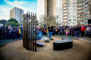
Artwork, other - Marker, Reko Rennie, Remember Me: Stolen Generations Marker, 2018
Kamilaroi artist Reko Rennie’s vision is an inclusive environment where people can sit and peacefully reflect on, mourn and acknowledge the deep trauma of the past, as well as connect with the ongoing strength and resilience of the Aboriginal community and support the process of healing. 'Remember Me' symbolises community resilience, identity and family. Positioned in a ceremonial ring, the seating and spears create a circle of gathering and remembrance within the park. In a contemporary and historical sense, the spear is an emblematic statement about struggle and adversity, and it is also an expression of identity and connection to land and culture.The 'Stolen Generations Marker, Remember Me', reflects the community’s wish to create a permanent tribute to the Stolen Generations and their families; a place of reflection and respectful commemoration. Integral to this is the surrounding garden with plants local to the area that have been re-introduced into the setting. Sited at the historically important Meeting Place in the heart of Aboriginal Fitzroy, the artwork honours not only the story of this place, but of all Aboriginal people who were taken away. This project was guided by the Stolen Generations Marker Steering Group and realised by Yarra City Council in partnership with the Victorian Government. Most importantly, it has received widespread grassroots community support. It was officially launched on the 20th anniversary of National Sorry Day (26 May 2018), which acknowledges the impact of the policies spanning more than 150 years of forcible removal of Aboriginal and Torres Strait Islander children from their families. On 26 May 1997 the landmark 'Bringing Them Home' report was tabled in Federal Parliament. The report was the result of a national inquiry that investigated the forced removal of Indigenous children from their families. This was a pivotal moment for many Stolen Generations. It was the first time the stories of forced removal were formally acknowledged by the Government and a recognition that these actions were inhumane. The impacts have been lifelong and intergenerational. A collection of bronze spears and a coolamon with accompanying seating, lighting and landscaping positioned in a ceremonial ring.stolen generations, fitzroy -
 St Kilda Historical Society
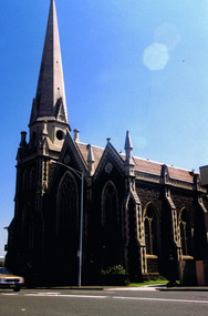
Photograph, St Kilda Presbyterian Church exterior - images collection, c 1970s
The St Kilda Presbyterian Church is now part of the St Kilda & Balaclava Presbyterian Church. Its first service was inaugurated by the Free Church Synod of Victoria in May 1855, in a building at the corner of High Street and Alma Road. In October 1855 the congregation moved to a wooden building in Inkerman Street, purchased from the Independent (Congregational) Church. The present church site was purchased and the first church opened in 1860. The foundation stone for the present church building, the second to be built on the site, was laid by the Governor of Victoria, Sir Henry Brougham Loch, on 27 January 1885. The building was opened on 30 May 1886. Wilson and Beswicke were the architects. Ralph Wilson designed the Methodist church on the corner of Princes and Fitzroy Streets and lived diagonally opposite the Presbyterian church. Charles Beswicke had toured Britain and the Continent in 1886 armed with a camera and returned to Australia with photographs of what he considered the greatest examples of architecture. He was responsible for the town halls in Brighton, Malvern, Hawthorn and Essendon and Wesleyan churches in Camberwell and Dandenong. Thomas Corley was the builder. The lofty spire was ‘a landmark to the mariner’ used by sea captains sailing up Port Phillip Bay. On a prominent position, the highest point in St Kilda, the church attracted wealthy people with legal, merchant and pastoral backgrounds.colour photographst kilda, churches, presbyterian church, balaclava -
 Wooragee Landcare Group
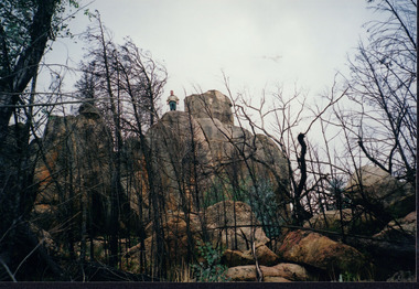
Photograph, circa April 2003
This photograph was taken in the Mount Pilot Chiltern National Park. This park is located near Chiltern in Victoria. It's most notable landmarks include Mt Pilot and Woolshed Falls. It also has many mines from the Gold Rush in the late 1800s. It is home to much flora and fauna, including the tiger quoll. The tiger quoll, also known as the spotted-tail quoll, is a marsupial that gives in the Mount Pilot Chiltern National Park. It is also main land Australia's largest carnivorous marsupial. It can weigh up too four kilograms and looks similar to either a possum or a spotted cat. It has red and brown fur with distinct spots. The tiger quoll is found along the Great Dividing Range, which includes Victoria, New South Wales and also near the border of Queensland. It lives in forests, rainforests and coastal heathlands and woodlands. In 2004 a team of volunteers from the Wooragee Landcare group as well as some of the Department of Sustainability and Environment staff set out to find the tiger quoll following the 2003 bushfires. Since the bushfires, concern had arisen for it because it hadn't been seen since the bushfires. They attempted to find traces of the quoll through finding and identifying their droppings as well as DNA testing. This photograph was taken during this search. This photograph represents the work that goes into protecting a important species like the tiger quoll. The tiger quoll is a significant species because it is main land Australia's largest carnivorous marsupial. As a result of this, there has been much work done to preserve and protect it. This photograph was taken when the Wooragee Landcare group went to ensure the survival of this species, highlighting how the tiger quoll is being protected. This photograph also demonstrates the impacts of the 2003 bushfires in the Mount Pilot Chiltern National Park. This is seen through the burnt trees featured in the picture. Landscape coloured photograph printed on gloss paperReverse: WAN NA 0ANA0N0 NNN 0 1636 / [PRINTED] (No.7) / 921quoll, mount pilot chiltern national park, national park, 2003 bushfires, search, endangered, beechworth, wooragee landcare group, wooragee landcare, wooragee, possum, australia, victoria, department of sustainability and environment, photograph, 2004, spotted-tailed quoll, great dividing range, spots, fur, forests, rainforests, woodlands, coastal heathlands, spotted quoll, spotted quoll habitat -
 Bendigo Historical Society Inc.
Book - VISION SPLENDID BENDIGO, 1986
Vision Splendid Bendigo. Cream coloured paper 56 pages, with line drawings of landmark buildings of Bendigo. Drawings by Jan Neil. Vision Splendid Introduction, Wesleyan Church Golden Square, Sacred Heart Cathedral, Central Deborah Mine, Marlborough House, Fuse factory, Goldmines Hotel, Fortuna Villa, Bon Accord, Heinz Butcher Shop, Long Gully State School, California Gully State School, Stone cottage Harvey Town, Eaglehawk Town Hall, Caradon, Eaglehawk State School, Victoria Hotel, Bendigo Pottery, Eucalyptus Distillery, St Luke’s, Lake Weeroona, Joss House, Benevolent Home, Lansellstowe, Kaithness, Malmo Valentine Street, Dudley House, Rifle Brigade Hotel, Fire Station, Masonic Hall, Temperance Hall, Old Post Office, Wesley Church, St. John’s Church, Alexandra Fountain, Commercial Bank View Point, State Bank, St Paul’s Cathedral Railway Station, National Bank, Town Hall, Post Office, Shamrock Hotel, Camp Hill State School, Police Barracks, Law Courts, Specimen Cottage, Technical College, St. Kilian’s Church, Tram Depot, St. Aidan’s OrphanageJan Neilbendigo, buildings, heritage buildings, heritage, heritage buildings, bendigo. -
 Eltham District Historical Society Inc
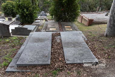
Photograph, Peter Pidgeon, Reynolds family grave, Eltham Cemetery, Victoria, 5 April 2021
Ernest Richard Reynolds was born June 1877, the son of Richard Reynolds and Sophia Allen. He married Elsie Mary Prior in 1913, the daughter of Thomas John Prior and Keziah Nutt. Ernest and Elsie had three children: Margaret Winifred (1914), Richard John (1915) and Ivy Beatrice (1917). The Reynolds family home was located at what is now 106 Thompson Crescent near the corner of Reynolds Road and Main Road. Reynolds Road was named after the family. Many historic photos of the district which now form part of the Reynolds/Prior and Shire of Eltham Pioneers Photograph collections were taken by Elsie’s brother, Henry Thomas (Tom) Edmond Prior and give a fine overview of many of the landmarks of Research and Eltham over 100 years ago. He was very innovative and made his own camera, using the black cloth hood to exclude the light. In Loving Memory Of Ernest Richard Reynolds Died 11th Oct 1960 Aged 83 yrs Elsie Mary Reynolds Died 2. 6. 89 Aged 98 years and In Loving Memory Of Margaret Winifred Reynolds Died 29. 12. 95 Aged 80 years Ivy Beatrice Reynolds Died 7 October 2011 Aged 94 years In His Loving CareBorn Digitaleltham cemetery, gravestones, elsie mary reynolds, ernest richard reynolds, ivy beatrice reynolds, margaret winifred reynolds -
Glen Eira Historical Society
Book - CAULFIELD CENTENARY 1957
This file contains four items 1/Two copies of a twenty-four page booklet titled CITY OF CAULFIELD CENTENARY 1857-1957, created by the Caulfield City Council and printed by Peter Isaacson Pty Limited, Melbourne. The booklet details important aspects of Caulfield’s history including council procedures, the Caulfield Road District Proclamation, the first election and a summary of 100 years of local government with a description of the present Caulfield in 1957. The booklet also includes several pictures of various Caulfield landmarks and people including one of Caulfield City Councillors (11 men and 1 woman). Also one photocopied version of this booklet. 2/Eleven pages of typed notes for the City of Caulfield Centenary booklet. All notes are undated and incomplete. Two pages titled NOTES on THE HISTORY and PROGRESS OF THE CITY OF CAULFIELD, author unknown. Three and a half pages titled THE STRUCTURE OF LOCAL GOVERNMENT IN VICTORIA, author unknown. Five pages titled 100 YEARS OF LOCAL GOVERNMENT – EARLY CAULFIELD, by Mrs A. P. Bell. 3/A typed letter to Miss V. Webb-Langdon from the Town Clerk H.G. Nelson, acknowledging her contribution to historical details for the Caulfield Council’s Centenary booklet, dated 24/12/1957. 4/A handwritten letter and a handwritten note regarding the acquisition of notes for the Caulfield Centenary booklet. The letter is dated 03/08/2006 and the note is dated 09/02/2007.city of caulfield centenary, caulfield road district, sinclair a.j.g., city hall, war memorials, gamble h.a., machin l.r., bunny f.c.d., caulfield park, koornang reserve, parton e.m., sims h.e., thomson w.r., gunn e.e., yorston j.s., wallace g.e. mrs, green w.c., jenner e.r., ward boundaries, dandenong road, queens avenue, normanby road, station street, bond street, glen eira road, orrong road, poath road, north road, booran road, nepean highway, glen huntly road, glenhuntly road, inkerman road, hotham street, nelson h.g., fullard w.r., mackley g.j., ellis k.i, crosbie m.r., nutting b.i., body j.h., pritchard r.j., guildford l.t.g., lund l.m., street h.c., reynolds a.w., elections , political processes, local government, springthorpe reserve, greenmeadows gardens, business and finance, roads and streets, caulfield racecourse, east caulfield reserve, mackinnon reserve, hawthorn road, balaclava road, murrumbeena road, lempriere avenue, victoria street, koornang road, lord reserve, lyons street, murrumbeena reserve, kangaroo road, ormond park, beatty crescent, foch street, packer reserve, oakleigh road, leila road, prices park, bambra road, riley reserve, playgrounds, town hall, maternal and child health centres, truganini road, grange road, senior citizens centre, barkley sir henry, moore david, handasyde gilbert, caulfield school room, harris g.w., semple john, dempsey william, brooks w.a., wilson thomas, lyall william, murrum murrumbeen lifestyle, ‘greenmeadows’ house, lempriere family, aboriginal culture, ‘rippon lea’ house, caulfield john, ‘slaney’s’ home, alma road, paddy’s swamp, racecourse hotel, caulfield technical college, bevan mr., ‘grosmont’, hart john, railways, mansions, ‘rosecraddock’, langdon h. j., caulfield cup, ‘crotonhurst’, webb judge, ‘kilwinning’, service james, ricketson henry, ‘glen eira’, house names, garden vale, ross william murray, ‘ross’s folly’, outer circle railway, caulfield grammar school, davies j. henry, lagdon william, grimwade f.s., loyd charles du plan, hope george, ‘airdrie’, kooyong hill, market gardens, dairies, lady talbot milk supply, jenner family, o’niell college, presentation sisters, glenferrie road, grimwade frederick sheppard, grimwade alice, ‘harlston’, grimwade house, ‘saint aubin’s’, ‘st. aubin’s’, ‘caulfield hall’, caulfield john p.t., st georges road, caulfield military hospital, nursing homes, health establishments, dover street, sports and recreations, rosanna street, ‘cantala’, health services, parks and reserves, community services, town planning, local government finance, local officials and employees -
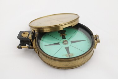 National Communication Museum
Equipment - Prismatic compass, Alfred E Sawtell, before 1872
After years of precursory surveying, debate and proposals the most ambitious civil engineering project of the day, the Overland Telegraph Line, began construction in September 1870. Superintendent of Telegraphs, Sir Charles Todd led the construction through “terra incognita,” guided by the precursory surveys of John McDowall Stuart and technologies such as his prismatic surveying compass. The unknown and hostile landscape claimed the lives of several men and scores of transport animals in the dogged pursuit of telegraphic connection to the rest of the world. Completed in August 1872, the Line connected Australia to the world via telegraph wires running 3,200 kilometres from Port Augusta in South Australia, to Darwin, then connecting via submarine cable to Java and beyond. The “earth [had been] girdled with a magic chain” according to the then Governor of New South Wales, Sir Hercules Robinson. How does it work? For use in surveying, the sight vane and prism are turned up on their hinge and the instrument is held horizontally either in the palm of one's hand or on a tripod. Two small discs of red and green glass attached to the prism can be flipped down over the sight line to reduce glare. The objective is to bring the subject into the sightline created by the prism, aligning with the thread of the sight-vane until the subject is bisected evenly. Once aligned, the division on the card may be read through the prism. This reading provides the magnetic azimuth, used for calculating the bearings of distant landmarks. Circular instrument mounted in a brass case with glass window and brass lid. The compass card face four black compass points printed on mint green paper; on the underside the magnetic needle would be affixed, all held in place by a brass knob at the centre. The arched labels of "Sawtell" and "Adelaide" and the Prince of Wales feathers appear to have been affixed with adhesive which has since yellowed in the areas of application on the compass card. The compass face is printed with numbers, every 10 degrees from 10 - 360, printed in reverse indicating this compass would have once held a mirror at the sighting bracket. On one side of the brass case is a brass hinged sighting-prism, possibly of ebonite. The sighting-prism is mounted in a hinged brass bracket on one edge of the brass case. It has two flip-type filter glasses (red and green) and folds down into a retracted travelling position. A hinged brass bracket on the opposite edge would have held the sighting bracket - carrying the sighting vane and mirror - which is now missing or removed. Under the hinge is a lever, possibly related to the movement of the bracket. Underneath the brass case is an indented circle with screw threads, possibly for attachment to a tripod, and indistinguishable marks scratched into the surface.Etched on to the centre of the lid, "Sawtell ADELAIDE / No 792." Affixed to the paper compass face, possibly from separate pieces of paper, "SAWTELL / ADELAIDE" with the Prince of Wales Feathers above "SAWTELL". Underneath on remains of white tape in red: "159."surveying, compass, charles todd, overland telegraph line, telegraph -
 Ballarat Heritage Services
Photograph - Colour, Clare Gervasoni, University of Melbourne Old Law Building, 2010, 29/09/2010
Melbourne University Old Physics Building (1889) was designed by Reed, Henderson and Smart. It later house the Univesity's Centre for Indigenous Education and a conference centre (2010).Colour photograph of the windows of the Melbourne University Old Physics Building.A plaque on the wall of this building states: In April, 1856 stonemasons woking on this building downed tools, marched to the city and inaugrated a movement which win the Eight Hour Day for building workers in Victoria. The victory became an international landmark in the history of the labour movement. Another plaque reads: This, the original building of the University was built of Tasmanian freestone between 1854 and 1857 to the design of F.M. White, architect. It was for many years the University's administrative centre, library, lecture rooms, and professorial residences. The east and west wings were extended in 1930 to the design of J.S. Gawler. In 1969, the quadrangle was completed by the addition of the southern wing which contains the council chamber, designed by R.E. Featherstone. A third plaque states: These cloisters, commenced in 1853 and extended in 1930 nd 1969 were completed in 1981 through the generosity of the late Edward Stevens, a member of Council from 1926 until 1939. The work was also supported by the Wilson Trust and Sir Wilfred Brookes.university of melbourne, old law building, eight hour day, stonemasons, tasmanian freestone, cloisters, edward stevens, wilson trust, wildred brookes -
 Bendigo Historical Society Inc.
Document - ALBERT RICHARDSON COLLECTION: SECRETARY FOR MINES ANNUAL REPORT 1911
Three page typed report titled ' Notes on diagram showing pitch lines, Bendigo'. Longitudinal sections along the lines of reefs or anticlines within the 8 mile block at Bendigo are shown in a diagram' (diagram not included with notes) Mines and reef lines mentioned in the report are : New Chum line, New Chum Railway mine, Catherine United mine, Hercules and Energetic mine, Garden Gully, Hustlers and Redan, Sheepshead Reef, Sea Mine, Garden Gully, Miller's line of reef and Bendigo Development Mine. The 'old stacks' or chimneys, on Bendigo are described. 'Among the earliest of the stacks built at Bendigo in connexion with Quartz crushing plant, are the two figured in this Annual report No 1 was situate in Sailor's Gully but was demolished about three years ago. This, if not the first, must have been one of the first built, for it had a stone inserted on which chiselled the date 1854. It was built altogether of rough masonry. The other, No. 2, is still standing at the Sheepshead line and was apparently of later date, the upper portion being of brick. They are intersting landmarks of an era that is rapidly passing.' Map attached to report showing location of stacks. Stack at Sailors Gully was near the corner of Murchison Street and Lester Street. The stack at Sheepshead ( Deborah Triangle area) was near the intersection of Belle Vue Road and Adam Street.bendigo, mining, pitch lines bendigo -
The Ed Muirhead Physics Museum
Rotating Anode X-ray Tube
The investigation of the x-ray appears early on to have been a priority research topic at the University of Melbourne’s School of Physics. This interest was sparked by the appointment in 1889 of Professor T.R. Lyle. Lyle, who was head of the school until 1915, is thought to have been the first person in Australia to have taken an x-ray photograph. A copy of this photograph can be found in the School of Physics Archive. For this particular experiment Lyle actually made his own x-ray tube. His successor, Professor Laby, continued to work with x-rays. During the 1920s Laby worked on the x-ray spectra of atoms and in 1930 he co-published with Dr. C.E. Eddy, Quantitative Analysis by X-Ray Spectroscopy. Also with Eddy, Laby produced the landmark paper Sensitivity of Atomic Analysis by X-rays. Laby went on to have an x-ray spectrograph of his own design manufactured by Adam Hilger Ltd. (see cat. No. 38). School of Physics, the University of Melbourne Cat. No. 22. Jacqueline Eager Student Projects Placement, Cultural Collections 2005 A modern X-ray tube differs little from the original Coolidge tube. A minor modification is the rotating anode type that extends the life and increases the available power of the tube by presenting a new portion of the anode when required. “P125/20/40/NrF038803 (?) SIEMENS-REINIGER-WERRE AG ERLANGEN Eigen filleung (?) mind. 0,7 mm AL” On rotating shaft: “FO/33803” On cathode: “23C” -
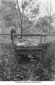 Eltham District Historical Society Inc
Photograph, The Rose Stereograph Company, Log Bridge, Eltham Road. Greensborough, c.1920
A woman stands at the end of a log bridge over a creek looking towards the south along the unsealed roadway. The sun illuminates her back. She is wearing a woollen knit beanie with edges rolled up, dark jacket and skirt, full length dark stockings and slip on dark leather shoes with raised heel, typical of the early 1920s. The creek is possibly feeding into the Karingal Yalloc. The direction of the road based on shadows is northwest as is the Eltham Road to Greensborough (present day Sherbourne, Karingal and St Helena roads). The creek is falling to the foreground so from south west to the north east, possibly feeding into the Karingal Yalloc, somewhere near presenet day Ramptons Road Reserve. This glass plate negative was used to manufacture postcards (1:1 printing) for commercial sale by the Rose Sterograph Company and its subsidiaries. George Rose founded the Rose Stereograph Company in 1880 and was joined by Herbert (Bert) Cutts in the early 20th Century. The pair formed a lifetime working partnership and strong personal friendship. Assisted by George’s two sons, Herbert George and Walter, and later by Neil Cutts, the Rose Stereograph Company continued its operations for more than 140 years. The company was initially built on stereographs, but as cinema took over and stereographs fell out of fashion, the Rose Stereograph Company developed Australia’s first commercially viable photographic postcard business. Specialising in postcards of iconic historical moments and significant landmarks, The Rose Stereograph Company became a staple of the Australian travel industry.This remarkable collection of glass plate negatives, transparencies, and postcards – arguably Australia’s most significant photography collection outside of public hands – has been passed down through the generations, surviving war, relocation, and the harsh Victorian climate. The historic Rose Stereograph collection is the culmination of George Rose’s dream of capturing and preserving precious moments in time and remains the legacy of the Rose and Cutts families. It is with great sadness that the Cutts family says goodbye to a collection that spans five generations and 140 years. The Cutts family understands that for these historically important pieces to rest with one family is to deny others the pleasure of their custodianship.Glass Plate Negative Size: 9.2 x 13.8 cmLog Bridge, Eltham Road, Greensborougheltham, postcard, travel, rose stereograph company, glass plate negative, creek, eltham road, greensborough, karingal road, karingal yallock, log bridge, sherbourne road, st helena road, women's fashion, rampton's road reserve, peter and elizabeth pidgeon collection -
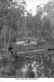 Eltham District Historical Society Inc
Photograph, The Rose Stereograph Company, A Pool, Eltham Road, Greensborough, c.1920
A boy of about ten years of age sits on the end of a fallen tree, which is resting in a natural pool in bushland. He is holding a stick gazing into the pool waters. He appears to be dressed in a schoolboy's uniform with close fitting short peaked cap, dark scarf or long sleeved jumper with polo neck and what appears to be a logo on the left breast, the ends of the sleeves turned over, dark shorts and dark long socks with ankle height lace up leather boots. The pool is located on the Eltham Road to Greensborough (present day Sherbourne, Karingal and St Helena roads) and is possibly part of the Karingal Yalloc somewhere near present day Ramptons Road Reserve. This glass plate negative was used to manufacture postcards (1:1 printing) for commercial sale by the Rose Sterograph Company and its subsidiaries. George Rose founded the Rose Stereograph Company in 1880 and was joined by Herbert (Bert) Cutts in the early 20th Century. The pair formed a lifetime working partnership and strong personal friendship. Assisted by George’s two sons, Herbert George and Walter, and later by Neil Cutts, the Rose Stereograph Company continued its operations for more than 140 years. The company was initially built on stereographs, but as cinema took over and stereographs fell out of fashion, the Rose Stereograph Company developed Australia’s first commercially viable photographic postcard business. Specialising in postcards of iconic historical moments and significant landmarks, The Rose Stereograph Company became a staple of the Australian travel industry.This remarkable collection of glass plate negatives, transparencies, and postcards – arguably Australia’s most significant photography collection outside of public hands – has been passed down through the generations, surviving war, relocation, and the harsh Victorian climate. The historic Rose Stereograph collection is the culmination of George Rose’s dream of capturing and preserving precious moments in time and remains the legacy of the Rose and Cutts families. It is with great sadness that the Cutts family says goodbye to a collection that spans five generations and 140 years. The Cutts family understands that for these historically important pieces to rest with one family is to deny others the pleasure of their custodianship.Glass Plate Negative Size: 9 x 14 cmA Pool, Eltham Road, Greensborougheltham, postcard, travel, rose stereograph company, glass plate negative, eltham road, greensborough, karingal road, karingal yallock, sherbourne road, st helena road, rampton's road reserve, schoolboy, peter and elizabeth pidgeon collection -
 Eltham District Historical Society Inc
Book - Photo album, The Reynolds/Prior photography collection
The Reynolds/ Prior collection of photographs were snapped by Tom Prior, the Uncle of Ivy Reynolds (her mother's brother) around 1900 and the 60 photos in the album give a fine overview of many of the landmarks of Research and Eltham over 100 years ago. lvy is a much loved pioneer who lived in the family home for many years at 106 Thompson Cres Research. Many today living in our township will know Ivy and remember her sister Margaret. Ivy's father, Ernst Richard Reynolds and grandfather, Richard Reynolds, lived at the same address. Ivy's father Richard worked for Mr. Trail on his property in Research. Reynolds Road is named after the family. Mr Tom Prior (wife Eva) worked at the Melbourne zoo. He was very innovative and made his own camera, using the black cloth hood to exclude the light. The photographs are a reminder of the rural nature of Research and Eltham and its rich heritage. Ivy Reynolds would like to share this history, stories and anecdotes with you. If they are not recorded and presented they are lost. In Andrew Lemon's Book Return to Research, A Centenary History of Research Primary School, there is a chapter-- reminiscing ..... the Reynold's family in Research 1870 to 1989 by Jenny Anderson With this in mind, Ivy would like to present the Reynolds/Prior collection in album form to the Historical Society of Eltham, and also to the Andrew Ross Museum, Kangaroo Ground. Ross McDonald 605 Mt Pleasant Rd Research, Vic 3095 (March, 2006 )The Reynolds family were early settlers in Research. The Reynolds/ Prior collection of photographs were taken by Tom Prior, the maternal uncle of Ivy Reynolds, around 1900 and the 60 photos in the album give a fine overview of many of the landmarks of Research and Eltham over 100 years ago. lvy lived in the family home for many years at 106 Thompson Cres Research. Ivy's father, Ernst Richard Reynolds and grandfather, Richard Reynolds, lived at the same address. Ivy's father Richard worked for Mr. Trail on his property in Research. Reynolds Road is named after the family. Mr Tom Prior (wife Eva) worked at the Melbourne zoo. He was very innovative and made his own camera, using the black cloth hood to exclude the light. The photographs are a reminder of the rural nature of Research and Eltham and its rich heritage. Album of photograps (rteproductions) and A4 photocopy (7 pages) contained in album, the Reynolds/Prior Photograph Collection giving background to collection and notes on photosThe Reynolds/Prior Photograph Collection, Presented to the Eltham District Historical Society, 14 June 2006 by Ross McDonald. A second copy was also presented to the Andrew Ross Museum, Kangaroo Groundreynolds prior collection -
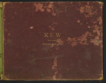 Kew Historical Society Inc
Book, Henry de Castres Kellett BT, Kew Where We Live : Kew Illustrated, 1891
At the beginning of the 1890s, the Kew businessman and Town Councillor, Henry Kellett, commissioned J.F.C. Farquhar to photograph scenes of Kew. These scenes included panoramas as well as pastoral scenes. The resulting set of twelve photographs was assembled in an album, Kew Where We Live, from which customers could select images for purchase.The preamble to the album describes that the photographs used the ‘argentic bromide’ process, now more commonly known as the gelatine silver process. This form of dry plate photography allowed for the negatives to be kept for weeks before processing, hence its value in landscape photography. The resulting images were considered to be finely grained and everlasting. Evidence of the success of Henry Kellett’s venture can be seen today, in that some of the photographs are held in national collections.It is believed that the Kew Historical Society’s copy of the Kellett album is unique and that the photographs in the book were the first copies taken from the original plates. It is the first and most important series of images produced about Kew. The individual images have proved essential in identifying buildings and places of heritage value in the district.A unique Illustrated book, comprising a series of twelve plates of panoramic and landscape photographs of Kew, commissioned from the Melbourne (and Kew) photographer JFC Farquhar, by the Kew stationer Henry Kellett. The book was published in 1891, so it is presumed that the photographs provided by Farquhar were taken in 1891 or in the previous year. Photographs from the cloth bound book were offered by Kellett for sale separately; hence a number are in public collections. The book is in very poor condition, the leaves having separated from the spine. The cover is suffering from red rot while the mounts of each book plate are dirty and frequently suffering from foxing. The actual silver albumen plates variably suffer from foxing and iridescence caused by the deterioration resulting from the photographic process. Each part of the book can be viewed in this record in sequential format.KEW WHERE WE LIVE / KEW ILLUSTRATED / THE ACCOMPANYING ILLUSTRATIONS ARE PHOTOGRAPHIC VIEWS OF KEW AND ITS SURROUNDINGS, EXECUTED BY THE "ARGENTIC BROMIDE PROCESS", WHICH ENSURES ABSOLUTE PERMANENCY OF THE PHOTOGRAPH. IN A FEW YEARS HENCE WHEN MOST OF THE OLD LANDMARKS WILL HAVE DISAPPEARED THESE VIEWS WILL BE A VALUABLE MEMENTO OF KEW AS IT WAS IN 1891. ANY OF THESE ILLUSTRATIONS GAN BE OBTAINED FROM MR. H. KELLETT, HIGH STREET, KEW, IN SINGLE COPIES, IN THE SAME SIZE AS THOSE HEREIN AT 2s PER COPY. THEY MAY ALSO BE OBTAINED IN THE FOLLOWING SIZES FOR FRAMING:- / ACTUAL SIZE OF PHOTOGRAPH 15 INCHES X 12 INCHES @ 8. 6d EACH / 22 INCHES X 16 INCHES @ 15s EACH / PRIVATE RESIDENCES AND ESTATES / SPECIAL ARRANGEMENTS CAN BE MADE FOR TAKING VIEWS OF PRIVATE RESIDENCES - INTERIOR AND EXTERIOR - AND FOR GROUPS, &C., IN ANY SIZE UP TO 40 INCHES BY 30 INCHES BY THE "ARGENTIC BROMIDE" PROCESS UPON APPLICATION TO / MR H. KELLETT / HIGH STREET, KEW.kew illustrated, kew where we live, photographic books, henry kellett, jfc farquhar - photographer -
The Ed Muirhead Physics Museum
Gas X-ray Tube
The investigation of the x-ray appears early on to have been a priority research topic at the University of Melbourne’s School of Physics. This interest was sparked by the appointment in 1889 of Professor T.R. Lyle. Lyle, who was head of the school until 1915, is thought to have been the first person in Australia to have taken an x-ray photograph. A copy of this photograph can be found in the School of Physics Archive. For this particular experiment Lyle actually made his own x-ray tube. His successor, Professor Laby, continued to work with x-rays. During the 1920s Laby worked on the x-ray spectra of atoms and in 1930 he co-published with Dr. C.E. Eddy, Quantitative Analysis by X-Ray Spectroscopy. Also with Eddy, Laby produced the landmark paper Sensitivity of Atomic Analysis by X-rays. Laby went on to have an x-ray spectrograph of his own design manufactured by Adam Hilger Ltd. (see cat. No. 38). School of Physics, the University of Melbourne Cat. No. 22. Jacqueline Eager Student Projects Placement, Cultural Collections 2005 The original X-ray tubes relied on low pressure operation. The electrons and positive ions are produced in the residual gas. Positive ions are accelerated towards the cathode and release electrons which on hitting the anode produce X-rays. These early gas X-ray tubes operated satisfactory only over a narrow pressure range. Stamped Label: “NATURAL PHILOSOPHY LABORATORY/ No/ UNIVERSITY OF MELBOURNE” Stamped: “90268 M. No. 5171[??]/No. 2156[??]/ M. No. 346585.” x-ray tubes, gas x-ray tube, laby, spectroscopy -
The Ed Muirhead Physics Museum
Gas X-ray Tube, Victor
The investigation of the x-ray appears early on to have been a priority research topic at the University of Melbourne’s School of Physics. This interest was sparked by the appointment in 1889 of Professor T.R. Lyle. Lyle, who was head of the school until 1915, is thought to have been the first person in Australia to have taken an x-ray photograph. A copy of this photograph can be found in the School of Physics Archive. For this particular experiment Lyle actually made his own x-ray tube. His successor, Professor Laby, continued to work with x-rays. During the 1920s Laby worked on the x-ray spectra of atoms and in 1930 he co-published with Dr. C.E. Eddy, Quantitative Analysis by X-Ray Spectroscopy. Also with Eddy, Laby produced the landmark paper Sensitivity of Atomic Analysis by X-rays. Laby went on to have an x-ray spectrograph of his own design manufactured by Adam Hilger Ltd. (see cat. No. 38). School of Physics, the University of Melbourne Cat. No. 22. Jacqueline Eager Student Projects Placement, Cultural Collections 2005 The original X-ray tubes relied on low pressure operation. The electrons and positive ions are produced in the residual gas. Positive ions are accelerated towards the cathode and release electrons which on hitting the anode produce X-rays. These early gas X-ray tubes operated satisfactory only over a narrow pressure range. Manufacturer’s mark stamped: “PATENTED/ VICTOR/ TRADEMARK/ MADE IN BOSTON U.S.A./ TUNGSTEN” A white circular stamp, stamped near the manufacturer’s mark: “[illegible]TER WIGGH[illegible]” Stamped label: “NAT. PHIL. LAB./ No./ UNIV. OF MELB.” Inscription on the end face of the copper piece: “PAT. SEP 5’ 11 DEC. 30’13/ JUNE 23, 14 NOV. 30.15/ 43835” -
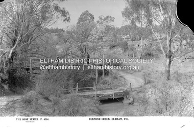 Eltham District Historical Society Inc
Negative - Photograph, The Rose Stereograph Company, Diamond Creek, Eltham, Vic, c.1919
Shows two bridge crossings over the Diamond Creek in Diamond Street, Eltham. The upper pedestrian crossing provided continual access for foot traffic during times of flood. The railway came to Eltham in 1901, the Eltham Railway Station is visible in the distance as well as a wooden bodied Tait (Red Rattler) First Class train carriage. The Tait train was first introduced in 1910 as a steam locomotive hauled carriage and in 1919 electric motor carriages were introduced however the line to Heidelberg was not electrified till 1921 and to Eltham in April 1923. The Railway General Store on Main Road is visible beyond the station and was built by Luther Haley in 1902. It was the first shop in the present day shopping centre. It was later known as lloyd's stopre (1917-1920) followed by a succession of six other owners until purchased by Eric Staff in 1939. This glass plate negative was used to manufacture postcards (1:1 printing) for commercial sale by the Rose Sterograph Company and its subsidiaries. George Rose founded the Rose Stereograph Company in 1880 and was joined by Herbert (Bert) Cutts in the early 20th Century. The pair formed a lifetime working partnership and strong personal friendship. Assisted by George’s two sons, Herbert George and Walter, and later by Neil Cutts, the Rose Stereograph Company continued its operations for more than 140 years. The company was initially built on stereographs, but as cinema took over and stereographs fell out of fashion, the Rose Stereograph Company developed Australia’s first commercially viable photographic postcard business. Specialising in postcards of iconic historical moments and significant landmarks, The Rose Stereograph Company became a staple of the Australian travel industry.This remarkable collection of glass plate negatives, transparencies, and postcards – arguably Australia’s most significant photography collection outside of public hands – has been passed down through the generations, surviving war, relocation, and the harsh Victorian climate. The historic Rose Stereograph collection is the culmination of George Rose’s dream of capturing and preserving precious moments in time and remains the legacy of the Rose and Cutts families. It is with great sadness that the Cutts family says goodbye to a collection that spans five generations and 140 years. The Cutts family understands that for these historically important pieces to rest with one family is to deny others the pleasure of their custodianship.Glass Plate Negative Size: 9 x 13.9 cmDiamond Creek, Eltham, Vic., The Rose Series P. 4314, Copyrighteltham, postcard, travel, rose stereograph company, glass plate negative, rose series postcard, tait train, eltham railway station, railway store, staffs general store, diamond creek, diamond street bridge, lloyd's general store, railway station, peter and elizabeth pidgeon collection -
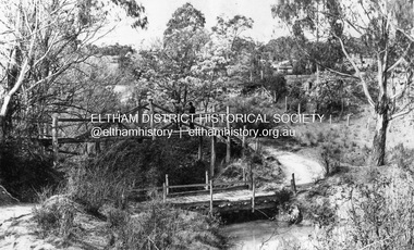 Eltham District Historical Society Inc
Negative - Photograph, Diamond Creek, Eltham. Old Diamond Street Bridge
Copy of Rose Series Postcard P. 4314. (The Rose Stereograph Company) Shows two bridge crossings over the Diamond Creek in Diamond Street, Eltham. The upper pedestrian crossing provided continual access for foot traffic during times of flood. The railway came to Eltham in 1901, the Eltham Railway Station is visible in the distance as well as a wooden bodied Tait (Red Rattler) First Class train carriage. The Tait train was first introduced in 1910 as a steam locomotive hauled carriage and in 1919 electric motor carriages were introduced however the line to Heidelberg was not electrified till 1921 and to Eltham in April 1923. The Railway General Store on Main Road is visible beyond the station and was built by Luther Haley in 1902. It was the first shop in the present day shopping centre. It was later known as lloyd's stopre (1917-1920) followed by a succession of six other owners until purchased by Eric Staff in 1939. George Rose founded the Rose Stereograph Company in 1880 and was joined by Herbert (Bert) Cutts in the early 20th Century. The pair formed a lifetime working partnership and strong personal friendship. Assisted by George’s two sons, Herbert George and Walter, and later by Neil Cutts, the Rose Stereograph Company continued its operations for more than 140 years. The company was initially built on stereographs, but as cinema took over and stereographs fell out of fashion, the Rose Stereograph Company developed Australia’s first commercially viable photographic postcard business. Specialising in postcards of iconic historical moments and significant landmarks, The Rose Stereograph Company became a staple of the Australian travel industry.This photo forms part of a collection of photographs gathered by the Shire of Eltham for their centenary project book,"Pioneers and Painters: 100 years of the Shire of Eltham" by Alan Marshall (1971). The collection of over 500 images is held in partnership between Eltham District Historical Society and Yarra Plenty Regional Library (Eltham Library) and is now formally known as 'The Shire of Eltham Pioneers Photograph Collection.' It is significant in being the first community sourced collection representing the places and people of the Shire's first one hundred years.Digital image 4 x 5 inch B&W Negdiamond creek, diamond street bridge, eltham, eltham railway station, glass plate negative, lloyd's general store, postcard, railway station, railway store, rose series postcard, rose stereograph company, shire of eltham pioneers photograph collection, staffs general store, tait train, travel -
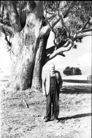 Federation University Historical Collection
Photograph - black and white, Mr Downing by the Federation University Tree of Knowledge, 1970
Federation University Mount Helen Campus was open to students in 1970. In that year Mr Dowling as photographed beside a big Tasmanian bluegum which was used a the centre Mount Helen Campus concept plan, and later became known as the Tree of Knowledge. Mr Dowling watered the tree after it was planted by his mother, Elizabeth Downing, on Arbour Day 1896. Mrs Downing raised her large family on the site of the Mount Helen Campus, which included an orchard and milking cows. The Tree of Knowledge is actually two trees, the trunks have fused together over time, and there is further evidence of fusion. The Downing farmhouse was situated in the vicinity of the present Administration and Caro Conference Centre buildings and the tree was planted beside the "dunny". It was carefully watered by the nine Downing children from a brick-lined well situated under what is now the Albert Coates Building. As the tree grew to maturity, it was used to hang a meat safe after slaughtering a sheep for the family table. Some years ago, when the foundations were being dug for the E-Building, an old rusted percussion pistol was found. One of Mrs Downing's sons, at that time well into his nineties, remembered getting into trouble for playing with it without permission, and losing it. The land was purchased in 1966 as part of a 241-acre site for Ballarat's new tertiary institution. When the architects and planners inspected the site, they decided "The Big Tree" must remain as a central landmark in preparing the layout of the campus amenities. In 1982, the spread of the tree was 36 metres, girth 7 metres, and height 36 metres. By 2003 the spread was 39.5 metres (N-S) and 35.5 metres (E-W), girth 7.75 metres, and height 42.5 metres. A man in overalls and jacket stands beside the Federation University Tree of Knowledge. Stage one buildings on the Mount Helen Campus are evident in the background.elizabeth downing, downing, tree of knowledge, big tree, mount helen campus, mount helen -
 Federation University Historical Collection
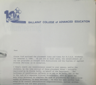
Document - Folder, Margaret Stevens Nursing (Clinical Experience) Folder, 1981-1986
Margaret Stevens was the inaugural Head of Nursing at the Ballarat College of Advanced Education from June 1985 until her retirement in 1989. During the 1980s there was a growing acceptance around Australia that Nurse Education needed to be more science based to allow nurses to cope with the vastly increased appearance of technological devices in the hospital wards. The response was to shift such training into Higher Education institutions. The State Government decided that Nurse Training in Ballarat should move from the Hospital to Ballarat College of Advanced Education. in 1986. Margaret Stevens had been a senior Nurse Educator at the Ballarat Base Hospital for many years and was selected by mutual agreement between the two institutions to devise the new course and plan its implementation so that it would gain the approval of the Nurse Registration authority. In addition to consulting widely with other Nurse Education specialists and supporting departments in Ballarat College of Advanced Education, Margaret negotiated with over 70 medical establishments to work out arrangements by which the students would be placed in work experience as required by the course. She was also involved in the required additional staff appointments and in planning for a new building on Campus. The course was commenced in 1986 and the transition successfully achieved, thanks largely to Margaret's diligence. In 1987 the Review of Registration of Health Practitioners interim report was published by the Health Department Victoria. Margaret Stevens was appointed by the Health Minister to represent the College of Nursing, Australia. This was a landmark review with long-reaching implications. At the time of her death on 23 March 2015 she was a member of the Board of Ballarat Community Health, and was identified as follows R.N.; B.App.Sc (Nursing); Post Basic: DipEd(N); Kellogg Fellow (USA 1984-85), M.Ed. (USA) & 1st program of M.Ethics Grey lever arch folder of notes, faxes and timetables relating to the teaching of the Diploma pf Applied Science (Nursing) at Ballarat College of Advanced Education (now Federation University Australia). Includes a letter of Ballarat College on Advanced Education 10th Anniversary letterhead, student lists, student placement, timetablesnursing, anniverary, letterhead, ballarat college of advanced education, elaine duffy, jan drennan, university women -
Federation University Historical Collection
Book, John Mawurndjul: I am the Old and the New, 2018, 2018
Hardcovered book with an image of a crocodile with rarrk design. The book is a catalogue for an exhibition developed and co-presented by the MCA and the Art Gallery of South Australia (AGSA), in association with Maningrida Arts & Culture, this exhibition presents the work of one of Australia’s leading contemporary artists – master bark painter John Mawurndjul. Bringing forth a tradition shared by generations of Kuninjku artists, Mawurndjul is celebrated for his mastery of rarrk (cross-hatching) and his depiction of djang (sacred sites). Bark paintings and sculptures made over a thirty five year period, from private and public collections, and chosen by the artist, will introduce audiences to the concepts that shape Kuninjku culture and the significant ancestral locations in Central Arnhem Land. Born in 1952, Mawurndjul is a Kuninjku elder and artist. He lives and works in Milmilngkan and Maningrida in Central Arnhem Land. Since his first exhibition in 1982, he has become one of Australia’s most widely recognised artists. In 1989 he was included in the landmark exhibition Magiciens de la Terre at the Centre Pompidou and Grande Halle de la Villette in Paris, and his works have been included in numerous solo and group exhibitions in Sydney, New York, Paris and Japan. Following the presentation of this exhibition at the MCA, it will be presented at AGSA from 26 October 2018 until 28 January 2019 as part of TARNANTHI Festival of Contemporary Aboriginal and Torres Strait Islander Art.(https://maningrida.com/exhibition/john-mawurndjul-old-new/, accessed 05 November 2018) non-fictionjohn mawurndjul, bark painting, exhibition catalogue, rarrk -
Eltham District Historical Society Inc
Document - Folder, Marshall, Marguerite
Marguerite Marshall, Eltham resident, worked as a journalist in the Diamond Valley from around 1980. In 2002, she published "Nillumbik Now and Then", about the shire's landmarks and characters (an update of "Eltham Shire, Historic Buildings, People and Places" 1983). It had photographs b Alan King and covered the Wurundjeri people, the Batman Tree legend, farmers, bushranger, gold mining, soldiers, artists, environmentalists and sportspeople. She was an environmental activist who created a comic character to show there can be a humorous side to the environmental challenge (Eartha Waters, a green tragic) for Nillumbik Climate Action Now event at Eltham Library. Contents Newspaper article: "New book on shire's past", Diamond Valley Leader, 6 February 2002, announcing publication of "Nillumbik Now and Then" by Marguerite Marshall, photographed with photographer Ron Grant and Eltham District Historical Society secretary Russell Yeoman. Newspaper article: "Humorous side on warming", Diamond Valley Leader, 4 June 2008, listing events for Nillumbik Climate Action Now marking World Environment Day, including Marguerite Marshall's character Eartha Waters. Newspaper article: "Green wedge a goldmine of history", Heidelberg and Diamond Valley Weekly, 25 November 2008, Announcing publication of Marguerite Marshall's book "Nillumbik Now and Then". Newspaper letter: "Worst, so we should lead", Diamond Valley Leader, 13 January 2010, Marguerite Marshall argued for climate action. Newspaper article: "Truths to be revealed in talk", Diamond Valley Leader, 23 July 2014, announcing talk by Marguerite Marshall on climate change at Montmorency Probus Club on 21 August and on renewable energy at Nillumbik Probus Club on 10 September 2014. Newspaper article: "Turning back the pages", Diamond Valley Leader, 19 November 2008, Announcing publication of Marguerite Marshall's book "Nillumbik Now and Then". Newspaper clippings, A4 photocopies, etcmarguerite marshall, nillumbik - now and then, eltham shire historic buildings people and places, ron grant, russell yeoman, eltham district historical society, eartha waters greenie tragic, nillumbik climate action now, alan king, montmorency probus club, nillumbik probus club -
 Eltham District Historical Society Inc
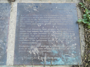
Photograph, Liz Pidgeon, Heritage Excursion; Eltham Lower Park Walk and Talk, 1 July 2017, 1 July 2017
Transcription of plaque: Not Just a Pretty Place acknowledges the cultural significance of this site for residnets of the Nillumbik Shire and for the Wurundjeri community. Historically the confluence of rivers have particular importance as these were sites where rituals and ceremonies took place. The carved bluestone form presents an oversize river pebble that echoes the spirit of the water and draws attention to this location as a meeting place and landmark. The oval shape of a coolamun (Wurundjeri dish or basket) is referenced in the sculpture as a reminder of the indigenous heritage and as a gesture to reconciliation Danko describes the work as a contemporary message stick or sign, that can be read as a merker of time, nature and human existance. 2000 Nillumbik Art in Public Places Award. Heritage Excursion - Saturday 1st July - Eltham Lower Park - Walk and Talk Eltham Lower Park has played an important part in the history of our area since the early days of European settlement when it was used by local residents as an informal racecourse. Prior to that its location at the junction of the Diamond Creek and the Yarra River made it an important meeting place for the Wurundjeri people. The park combines formal elements and sporting facilities with remnant bushland that is of environmental significance. It is home to sporting and horse riding clubs, popular play spaces and the Diamond Valley Miniature Railway, which attracts large numbers of visitors. The park will be the venue for our July excursion which will comprise a walk of about 3.5 km around the park and adjacent areas. Along the way we will discuss the history and natural history of the area. The path along the creek and the river provides a pleasant and scenic walk. This walk on Saturday 1st July is about 3.5 km in length and will take 2 to 2.5 hours. It will start at 2pm at the Main Road car park at the front of the park. (Melway ref 21 H 10). From Newsletter No., 234, June 2017 Born Digitalelection day, heritage excursion, activities, eltham district historical society, eltham lower park, not just a pretty place, public art, plaque -
The Ed Muirhead Physics Museum
Coolidge X-ray Tube
The investigation of the x-ray appears early on to have been a priority research topic at the University of Melbourne’s School of Physics. This interest was sparked by the appointment in 1889 of Professor T.R. Lyle. Lyle, who was head of the school until 1915, is thought to have been the first person in Australia to have taken an x-ray photograph. A copy of this photograph can be found in the School of Physics Archive. For this particular experiment Lyle actually made his own x-ray tube. His successor, Professor Laby, continued to work with x-rays. During the 1920s Laby worked on the x-ray spectra of atoms and in 1930 he co-published with Dr. C.E. Eddy, Quantitative Analysis by X-Ray Spectroscopy. Also with Eddy, Laby produced the landmark paper Sensitivity of Atomic Analysis by X-rays. Laby went on to have an x-ray spectrograph of his own design manufactured by Adam Hilger Ltd. (see cat. No. 38). School of Physics, the University of Melbourne Cat. No. 22. Jacqueline Eager Student Projects Placement, Cultural Collections 2005 In 1913 Coolidge overcame the limitation of the narrow operating range of the gas X-ray tubes with the invention of the vacuum X-ray tube. A filament heated by an electric current directly releases electrons by thermionic emission. In thermionic emission, electrons are emitted from a metal surface directly by the application of an electric current to heat a wire filament. The electrons accelerate to the anode and produce X-rays. The anode has associated cooling fins due to the high temperatures attained by the release of kinetic energy by the electrons on colliding with the anode. Internal Glass sleeve: “A941/L2593/2821” -
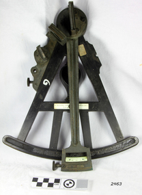
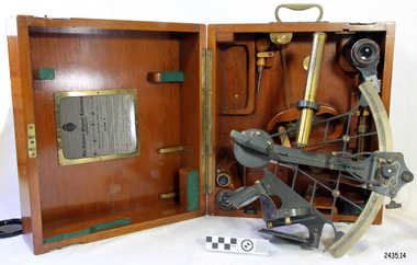 Flagstaff Hill Maritime Museum and Village
Instrument - Navigational Sextant, 1882-1890
A sextant is an astronomical instrument used to determine latitude and longitude at sea by measuring angular distances, especially the altitudes of the sun, moon, and stars. It is a doubly reflecting navigation instrument and used mainly by sailors to measure the angular distance between two visible objects. The name comes from the Latin sextans, or “sixth part of a unit,” because the sextant’s arc can be 60° or 120° of a circle depending on the model used. The primary use was to measure the angle between an astronomical object and the horizon for the purposes of celestial navigation. The estimation of this angle is known as sighting or shooting the object, or taking a sight. This angle and the time when it was measured is used in order to determine Greenwich Mean Time and hence longitude. Sighting the height of a landmark on land can also give a measure of distance from that object. History: The development of the sextant was as an improvement over the octant, an instrument designed to measure one's latitude. The octant was first implemented around 1731-present but can only measure angles up to 45°. As larger angles were needed to allow the measurement of lunar objects - moon, stars and the sun - at higher angles, the octant was superseded by the sextant. The sextant is a similar instrument but better made and allows larger angles from 60° to 120°. This improvement allows distances to be accurately calculated thereby giving longitude when used with a chronometer. The sextant was derived from the octant in 1757, eventually making all previous instruments used for navigational positioning obsolete. The sextant had been attributed to by John Hadley (1682–1744) and Thomas Godfrey (1704–1749), but reference to the sextant was also found later in the unpublished writings of Isaac Newton (1643–1727). Earlier links can be found to Bartholomew Gosnold (1571–1607) indicating that the use of a sextant for nautical navigation predates Hadley's implementation. In 1922, the sextant was modified for aeronautical navigation by Portuguese navigator and naval officer Gago Coutinho. It should be noted that the octant and quadrant are in the same family as they were, and all are, regarded as sextants. The sextant is representative of it's type and although not fully complete it demonstrates how 18th,19th and 20th century mariners determined their latitude and longitudinal to determine their position on a chart, allowing them to navigate there way across the world's oceans. It also demonstrates the skill and workmanship of the early instrument makers that operated scientific instrument businesses from London and other areas of England to provide most of the navigational instrumentation used by commercial and military navies of the time.Sextant with square, fitted box of polished wood, "Hezzanith" brand. Box contains many parts for the sextants use. On certificate "Heath & Co, London. Sextant Number Y 822". Catch on lid "DEFIANT LEVER" and "PATENT NUMBER 187.10". Maker's certificate is attached to the inside of the box.flagstaff hill, warrnambool, shipwrecked-coast, flagstaff-hill, flagstaff-hill-maritime-museum, maritime-museum, shipwreck-coast, flagstaff-hill-maritime-village, sextant box, sextant, hezzanith, heath & co, navigational instrument, george wilson heath, astronomical instrument, instrument manufacturers, scientific instrument, navigation, celestial navigation, octant, quadrant, lunar navigation -
![1981 Warrnambool and District Community Information Directory front cover [.6]](/media/collectors/4f729f7797f83e030860184f/items/664fef1cdd0f9ab6b51abf51/item-media/66c27aa3202c41c4ca03b234/item-fit-380x285.jpg) Warrnambool and District Historical Society Inc.
Warrnambool and District Historical Society Inc.Booklet - Booklet Collection: City of Warrnambool Directory of Services, Collett and Bain
This is a collection of nine directories published by the City of Warrnambool dating from 1952 to 1992. They contain descriptions of the municipality and lists and details of services, social and community facilities for the period covered.These directories give snapshots of the City of Warrnambool for the years covered and will be useful for research.[.1] 16 pages printed with black and white photographs. The cover is cream card with writing in blue printing and the city of Warrnambool crest in the top left corner. [.2] 16 pages printed with black and white photographs. The cover is yellow card with writing in blue printing and the city of Warrnambool crest in the top left corner. [.3] 8 pages printed with pale yellow feathered design edges on either side of the text. The cover is cream with writing in Blue print and the pale yellow feathered pattern. A coloured City of Warrnambool seal is in the centre top third of the front cover. [.4] A single sheet of buff coloured light weight card folded in half to make a booklet. Black printing with a black Warrnambool crest in the top centre. [.5] 36 page booklet. The cover is of white shiny card with printed purple text. [.6] 96 page booklet. The cover has black printed text and red stylised cartoon like drawings representing different aspects of the community. [.7] 32 page booklet. The cover is of cream card printed with a 5mm wide green line across the front and back. Black ink drawings of Warrnambool landmarks by P Bryant feature on the cover and the Warrnambool City seal is in the bottom right hand corner. [.8] 20 page booklet of white paper with black text printing. There is a photo of the Tourist information centre on the rear cover. The Warrnambool city crest on the front cover which has a black geometrical edging design. [.9] 24 page booklet of white paper with black text printing. The front cover has the Warrnambool city crest in the top left hand corner and a photograph of the Lake Pertobe playground in the bottom two thirds. The back cover has a photo of the Warrnambool Saleyards. [.1] City of Warrnambool Victoria, Australia [.2] City of Warrnambool Victoria, Australia [.3] City of Warrnambool [.4] City of Warrnambool Organisations taking part in the Community Life of the City of Warrnambool 1952 [.5] Warrnambool Directory of Social Services [.6] Community Information Directory Warrnambool and District 1981 [.7] Community Information Guide 1991/1992 City of Warrnambool [.8] Citizens' Information Handbook for 1976-1977 [.9] Citizens' Information Handbook for 1977-1978 warrnambool, warrnambool city directory, warrnambool community organisations -
 Flagstaff Hill Maritime Museum and Village
Octant, Late 18th to mid-19th century
An Octant is a doubly reflecting navigation instrument used primarily by sailors to measure the angular distance between two visible objects and was a forerunner of the sextant. The name comes from the Latin octo, or “one-eighth of a circle,” for the Octant’s arc which spans 45°, or one-eighth of a circle. The primary use of an Octant is to measure the angle between an astronomical object and the horizon for the purposes of celestial navigation. The estimation of this angle is known as sighting or shooting the object, or taking a sight. The angle, and the time when it was measured, can be used to calculate a position line on a nautical chart (latitude), for example, sighting the Sun at noon or Polaris at night (in the Northern Hemisphere) gives an angle by which the latitude can then be estimated. Sighting the height of a landmark on land can also give a measure of distance. History: The principle of the Octant as an instrument to measure ones latitude was first implemented around 1742-present but was superseded by the improvement of the octant to a sextant, a very similar instrument, better made and able to measure bigger angles 120°, allowing the measurement of Luna distances to give longitude when used with an accurate chronometer. The sextant started to appear around 1730 and had been attributed to by John Hadley (1682–1744) and Thomas Godfrey (1704–1749), but reference to the sextant was also found later in the unpublished writings of Isaac Newton (1643–1727). Earlier links can be found to Bartholomew Gosnold (1571–1607) indicating that the use of a Sextant for nautical navigation predates Hadley's implementation. In 1922, the sextant was modified for aeronautical navigation by Portuguese navigator and naval officer Gago Coutinho. Henry Hemsley was a lesser-known instrument maker and optician working in London in the late 17th and early 18th century. However, it should be noted that there were two Henry Hemsley opticians and instrument makers around this period. (Henry Hemsley 1, 1786-89, who had premises at 85 Fleet St London and Henry Hemsley 2, 1828-56), whose workshop was at 135-138 Radcliff Highway London. Therefore, based on the inscribed workshop address Henry Hemsley 2 is responsible for making this example.The octant is representative of its type and although not fully complete it demonstrates how 18th and 19th-century mariners determined their latitude on a chart to navigate their way across the world's oceans in the 18th and 19th century. It also demonstrates the skill and workmanship of the early instrument makers that operated from London at this time and provided most of the navigational instrumentation use by commercial and military navies of the time.Octant, ebony wooden frame and handle. Scale is missing from recess in frame. "H. Hemsley 135-138 Ratliff Highway, London", no box"H. Hemsley 135-138 Ratcliff Highway, London"flagstaff hill, warrnambool, shipwrecked-coast, flagstaff-hill, flagstaff-hill-maritime-museum, maritime-museum, shipwreck-coast, flagstaff-hill-maritime-village, navigation, navigational instrument, instrument used for navigation, sextant, henry hemsley, instrument maker, london, octant -
 Ballarat Heritage Services
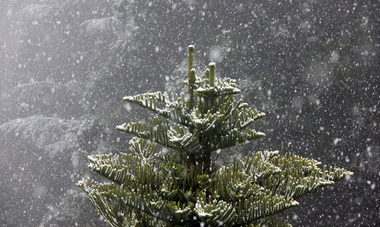
Photograph - Digital photographs, L.J. Gervasoni, Snow at the Wombat Hill Botanic Gardens, Daylesford, c2012-2016
The Daylesford Botanic Gardens are of historic, scientific (botanic), and aesthetic significance to the State of Victoria. The Daylesford Botanic Gardens are historically significant as a fine example of a regional botanic garden demonstrating the typical characteristics of a carriage drive, informal park layout, decorative structures and works such as the memorial tower, conservatory, rotunda, cascade and fernery, which contrasts with the open lawns planted with specimen trees, areas of intensive horticultural interest and close proximity to a township developed during the mid to late nineteenth century. The Daylesford Botanic Gardens are historically significant for the design input by noted landscape designer William Sangster, and for the survival of his 1884 plan, which is a rare example of a plan from this prolific garden designer. The Daylesford Botanic Gardens are of scientific (botanic) significance for the extensive conifer collection and cool climate plants. The Gardens contain an outstanding collection of conifers and other mature trees, many of which were donated by renowned botanist Ferdinand von Mueller. Significant trees include Pinus ponderosa (Western Yellow Pine), Pinus coulteri (Big Cone Pine), twoAbies nordmanniana (Caucasian Fir), Abies pinsapo, (Spanish Fir) and a Cedrus atlantica f. glauca(Blue Atlas Cedar), Pinus wallichiana (Bhutan Pine), Pinus pinaster (Maritime Pine), Sequoiadendron giganteum (Giant Redwood), (Monkey Puzzle) and Aesculus hippocastanum (Horse Chestnut), many the largest or finest examples in Victoria. Other outstanding trees include a Tilia cordata (Small-leaved European Linden), a row of Cupressus lusitanica (Mexican cypress), a Quercus robur (English Oak) planted in 1863, avenues of Dutch Elms and a rare Quercus leucotrichophora (Himalayan Oak). The Daylesford Botanic Gardens are of aesthetic significance as a rare example of a botanic garden spectacularly sited on an extinct volcanic cone which allows a panoramic view, aided by the 1938 Pioneers’ Memorial Tower, as well as vistas within and out of the gardens and from the township to the gardens. As the most prominent local landmark, the Garden’s vertical dominance in the landscape provides a dark contrast to the elms avenues, oaks and other deciduous species. (Heritage Victoria Register, )Digital imagesdaylesford, snow, weather, climate, winter, daylesford botanic gardens, botanic gardens, wombat hill, wombat hill botanic gardens, pinetum, trees, reservoir -
 Ballarat Heritage Services
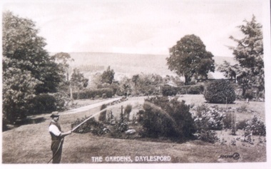
Photograph - Postcard, Wombat Hill Gardens, Daylesford
The Daylesford Botanic Gardens are of historic, scientific (botanic), and aesthetic significance to the State of Victoria. The Daylesford Botanic Gardens are historically significant as a fine example of a regional botanic garden demonstrating the typical characteristics of a carriage drive, informal park layout, decorative structures and works such as the memorial tower, conservatory, rotunda, cascade and fernery, which contrasts with the open lawns planted with specimen trees, areas of intensive horticultural interest and close proximity to a township developed during the mid to late nineteenth century. The Daylesford Botanic Gardens are historically significant for the design input by noted landscape designer William Sangster, and for the survival of his 1884 plan, which is a rare example of a plan from this prolific garden designer. The Daylesford Botanic Gardens are of scientific (botanic) significance for the extensive conifer collection and cool climate plants. The Gardens contain an outstanding collection of conifers and other mature trees, many of which were donated by renowned botanist Ferdinand von Mueller. Significant trees include Pinus ponderosa (Western Yellow Pine), Pinus coulteri (Big Cone Pine), twoAbies nordmanniana (Caucasian Fir), Abies pinsapo, (Spanish Fir) and a Cedrus atlantica f. glauca(Blue Atlas Cedar), Pinus wallichiana (Bhutan Pine), Pinus pinaster (Maritime Pine), Sequoiadendron giganteum (Giant Redwood), (Monkey Puzzle) and Aesculus hippocastanum (Horse Chestnut), many the largest or finest examples in Victoria. Other outstanding trees include a Tilia cordata (Small-leaved European Linden), a row of Cupressus lusitanica (Mexican cypress), a Quercus robur (English Oak) planted in 1863, avenues of Dutch Elms and a rare Quercus leucotrichophora (Himalayan Oak). The Daylesford Botanic Gardens are of aesthetic significance as a rare example of a botanic garden spectacularly sited on an extinct volcanic cone which allows a panoramic view, aided by the 1938 Pioneers’ Memorial Tower, as well as vistas within and out of the gardens and from the township to the gardens. As the most prominent local landmark, the Garden’s vertical dominance in the landscape provides a dark contrast to the elms avenues, oaks and other deciduous species. (Heritage Victoria Register, )Black and white postcard of Wombat Hill Botanical Gardens, Daylesford.wombat hill botanical gardens, daylesford, gardener, wombat hill botanic gardens -
 Ballarat Heritage Services
Photograph - Digital photographs, L.J. Gervasoni, Wombat Hill Botanic Gardens 150 anniversary event Daylesford community event, 2013
The Daylesford Botanic Gardens are of historic, scientific (botanic), and aesthetic significance to the State of Victoria. The Daylesford Botanic Gardens are historically significant as a fine example of a regional botanic garden demonstrating the typical characteristics of a carriage drive, informal park layout, decorative structures and works such as the memorial tower, conservatory, rotunda, cascade and fernery, which contrasts with the open lawns planted with specimen trees, areas of intensive horticultural interest and close proximity to a township developed during the mid to late nineteenth century. The Daylesford Botanic Gardens are historically significant for the design input by noted landscape designer William Sangster, and for the survival of his 1884 plan, which is a rare example of a plan from this prolific garden designer. The Daylesford Botanic Gardens are of scientific (botanic) significance for the extensive conifer collection and cool climate plants. The Gardens contain an outstanding collection of conifers and other mature trees, many of which were donated by renowned botanist Ferdinand von Mueller. Significant trees include Pinus ponderosa (Western Yellow Pine), Pinus coulteri (Big Cone Pine), twoAbies nordmanniana (Caucasian Fir), Abies pinsapo, (Spanish Fir) and a Cedrus atlantica f. glauca(Blue Atlas Cedar), Pinus wallichiana (Bhutan Pine), Pinus pinaster (Maritime Pine), Sequoiadendron giganteum (Giant Redwood), (Monkey Puzzle) and Aesculus hippocastanum (Horse Chestnut), many the largest or finest examples in Victoria. Other outstanding trees include a Tilia cordata (Small-leaved European Linden), a row of Cupressus lusitanica (Mexican cypress), a Quercus robur (English Oak) planted in 1863, avenues of Dutch Elms and a rare Quercus leucotrichophora (Himalayan Oak). The Daylesford Botanic Gardens are of aesthetic significance as a rare example of a botanic garden spectacularly sited on an extinct volcanic cone which allows a panoramic view, aided by the 1938 Pioneers’ Memorial Tower, as well as vistas within and out of the gardens and from the township to the gardens. As the most prominent local landmark, the Garden’s vertical dominance in the landscape provides a dark contrast to the elms avenues, oaks and other deciduous species. (Heritage Victoria Register, )Digital imagesvictoria, 150, anniversary, botanic, gardens, wombat hill, botanic gardens, heritage, celebration, garden party, daylesford, people, crowd, community, john hawker, john madigan, stilt, trees, owls, wombat hill botanic gardens