Showing 1562 items
matching documents - maps
-
 Bendigo Military Museum
Document - RENOVATION SPECIFICATIONS BRSL, C. 1962 onwards
These renovations were first discussed by the Bendigo RSL in 1962 - 1963. This Document is headed, “Specifications of Workmanship and Materials required for Painting and Renovations etc, at R.S.S.A.I.L.A Hall, Pall Mall, Bendigo” There are 3 parts to the documents. First section has 22 parts, everything from “Tender - Insurance - Materials - Liability - Condition of Contract to the use of Sanitary conveniences. Second section has sections re “Carpenter and Joiner - Brick work - Plastering - Electrician - Painter and Glazier”. Each has sections under re their work to be done. Third section is a technical drawing of the Soldiers Memorial Institute minus the Main Hall, it shows scopes of work. The main works covered a new false ceiling in the Office, a new front door entrance to the Foyer in a different position, exhaust fan in the Billiard room, removal of a gate at the Stairwell entrance, fire place repairs, adding chair rails to walls to foyer, Committee room. These works were carried out. There was a false ceiling in the Meeting room but there was no mention re this in the above plans. This ceiling was removed during the 2016 - 2018 major renovations to the SMI. The false ceiling in the Office was removed in a major renovation to the room in 2011 - 2012 and taken back to original.Folder brown card covers with six typed in black pages and one map all black print, pages stapled in with 2 binder holes in.On front cover in black pen. "Specifications - Painting & Renovations R.S.L. Premises Pall Mall, Bendigo"brsl, renovations, smirsl -
 Warrnambool and District Historical Society Inc.
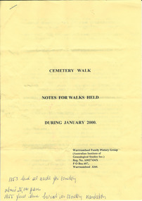
Document, Warrnambool Cemetery Walk 2000, 2000
The Warrnambool Family History Group was established in 1980. It has been running Warrnambool cemetery tours for a great number of years with the late Marie Boyce being a prominent organizer of these tours. The tours are usually held in January and on Anzac Day and over recent years have concentrated on a theme to provide information on a certain group of people (eg Mayors, war heroes). These sheets are a good example of the graves visited during the Warrnambool Cemetery tours and the information given on these people. These are two yellow A4 sheets typed back and front with information on people buries in the Warrnambool Cemetery and a sketch map of the Warrnambool Cemetery. The typed material has been annotated with handwritten notes (blue biro) by a participant on one of the walking tours.Front page: ‘Cemetery Walk, Notes for Walks Held During January 2000. Warrnambool Family History Group (Australian Institute of Genealogical Studies Inc) Reg. No. A0027436X, P.O. Box 607, Warrnambool 3260 (sic)’warrnambool family history group, warrnambool cemetery tours -
 Warrnambool and District Historical Society Inc.
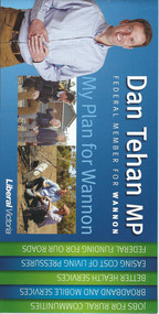
Document, Leaflet Federal Election, 2013
This is a 2013 election leaflet for Dan Tehan, the Federal Member for Wannon (Liberal Party). Wannon electorate is in the south west of Victoria and was one of the original seats established in 1900 for the first Federal Government. Warrnambool is in the Wannon Electorate. Dan Tehan won the seat in 2010 for the Liberal Party and has held it ever since. This is a leaflet of four pages and a cover. The printed material is multi-coloured with colour photographs, a map of the electorate and election statements and promises. There is one loose sheet printed in black and white. dan tehan, wannon electorate, warrnambool -
 Warrnambool and District Historical Society Inc.
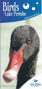
Document, Pamphlets lake Pertobe, 2014
Lake Pertobe in Warrnambool is a former swamp area which was transformed into a recreational area and children’s playground in the 1970s. The reserve is a popular spot for bird watching with over 80 species found in the vicinity. The brochure on Lake Pertobe’s birds had been produced by BirdLife Warrnambool, part of BirdLife Australia, an independent, not-for profit organisation aiming to protect our birdlife and disseminate information on Australian birds. This is an important little brochure as it contains information for locals and tourists about the birdlife in Lake Pertobe, one of the best-known and best-loved spots in WarrnamboolThis is an A3 sheet of paper printed on both sides and folded three times to form a brochure. It contains colour photographs of birds, two maps and information about BirdLife Warrnambool and BirdLife Australia and the logo of Birdlife Warrnambool.Front Cover: ‘Birds of Lake Pertobe, Warrnambool, BirdLife Warrnambool, Birds are in our nature’ lake pertobe, birdlife warrnambool, warrnambool -
 Warrnambool and District Historical Society Inc.
Documents, Swintons Paper att 18/53 Merri St. Contract. Map. Notes, 1959
... Merri St. Contract. Map. Notes Documents ...These documents relate to the sale of land in Merri Street Warrnambool in 1959 by Swintons Pty Ltd of Warrnambool. The buyer of the land was George O’Grady, a Warrnambool baker. The land sold for £4000 and there was a shed on the land (called the ‘Office’) which George O’Grady indicated he wished to be included in the sale. William and Ann Swinton migrated to Australia in 1854 and for a decade William Swinton worked as a builder and carpenter in the Warrnambool area, erecting many buildings, including the Wangoom Presbyterian Church. In 1865 he opened a store in Timor Street Warrnambool, selling groceries, hardware, china and glassware. By 1888 the business was known as William Swinton and Sons. Branch stores were opened in Wangoom, Cudgee, Nullawarre, South Warrnambool and West Warrnambool. After William Swinton died his son Robert became the first managing director of Swintons Pty Ltd. In 1934 the business split with George Swinton and Sons selling clothing, furnishings and glassware and Swintons Pty Ltd selling seeds, produce and hardware. Today the Swinton family still operates a furniture and bedding shop in Timor St Warrnambool.These items are of some interest as being connected to the Warrnambool business of Swintons Pty Ltd. They will be of interest to researchers. The current Swinton business in Timor Street is the oldest family business in Warrnambool and, with the name Swinton associated with businesses in Timor Street Warrnambool for 152 years it is amongst the oldest family businesses in Australia.The items here relate to the sale of land by Swintons Pty Ltd., Warrnambool. .1 These are three pages of white paper with typed material, a lawyer’s signature in blue ink, one green stamp and a sketch of the land location. .2 This is a sheet of thick paper containing a plan of the land sold. The paper has printed material and a sketch of the land with part of it coloured in pink. .3 This is a small piece of paper torn at the bottom right edge. It has handwritten material (a letter) in blue ink..2 ‘Plan of Survey of Part of Crown Allotment 18 Section 3 Township of .2 ‘Plan of Survey of Part of Crown Allotment 18 Section 3 Township of Warrnambool Parish of Wangoom County of Villiers’ .3 ‘Tuesday Dear Mr Swinton I am writing to say that I would like to have the ‘Office’ Thanking You George O’Grady’swinton family,, warrnambool -
 Warrnambool and District Historical Society Inc.
Document, Wollaston sale, 1919
This is a poster advertising the sale of part of the Wollaston Estate in Warrnambool in 1919. The sections for sale were Allotments 1, 18 and 19 which included the Wollaston Homestead. The original Wollaston property of 679 acres was selected by Thomas Manifold in the late 1840s. This land, on the northern side of the Merri River, near the Woodford Road was three kilometres from the Warrnambool town. The first farmer we know who leased the property was William Simpson. Walter Manifold inherited the property and he took it over in 1884. The swing bridge he built in 1890 still stands today. In 1919 the Closer Settlement Board of Victoria acquired Wollaston and 17 lots were sold to returned soldiers for farming purposes. By 1930 there were only five soldier settlers remaining. In 2009 further subdivision took place with lots sold for residential purposes. The homestead allotments were sold separately in 1919 with various owners of the homestead itself recorded since that time. This poster is of interest as it shows the areas of the Wollaston Estate which were sold in 1919. The history of this estate is well-documented and of importance in the history of Warrnambool. This is a sheet of paper with red and black printing and a map of the Wollaston Estate which is photo-lithographed. The sheet has been folded three times. It has some small tears at the top of the page. wollaston, history of warrnambool, walter manifold -
 Warrnambool and District Historical Society Inc.
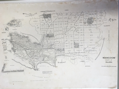
Document: Map, Map Wangoom County of Villiers, 1955
... Document: Map... but it is otherwise in good condition. Map Wangoom County of Villiers Document ...This map contains the names, acreage details and dates of the original property owners of the Parish of Wangoom (County of Villiers), excluding the township of Warrnambool. It also has details of the Crown Lands adjoining the Merri and Hopkins Rivers. This is a most important map as it has details on the original property owners. It is a most valuable research tool and is one of our most-used maps.This is a map, printed in black and white and mounted on cardboard. Where there was intensive land ownership the details have been reproduced in larger print on the margins of the map. There are scuff and dirt marks on the map but it is otherwise in good condition.‘Wangoom, County of Villiers’wangoom, warrnambool, county of villiers -
 Warrnambool and District Historical Society Inc.
Document, Map: Lady Bay 1853, 1853
... of warrnambool map 1853, tulloch & brown map 1853, lady bay warrnambool ...This is one of the earliest surveys and maps of Warrnambool harbor, Lady Bay. Being done in 1853, it shows the depths of the bay area marked in fathoms, currents and directions and areas of rocks around mouth of the Merri and the Western side of the bay as well as a large sand spit to the middle right of the beach region.. It also marks the large areas of seaweed and fuci in the outer bay area. It has the area of Pertobe Lagoon marked and shows the early tracks to the town. The engraving work was done by Tulloch and Brown, with Tulloch being one of the earliest engravers and lithographers in the state of Victoria. He arrived in Melbourne in 1849 and set up business with James Davie Brown in 1853 with Brown being a map engraver. They were awarded bronze and silver medals for their work at the Victorian Industrial Exhibition. He also worked in the vignettes on the Proeschel Map of Victoria.This map is of high historical and comparitive significance as it shows the Lady Bay area prior to the changes that have occurred in the last 160 years with the building of the breakwater. The issue regarding access to Lady Bay remains a current one. The engraver D Tulloch engraved some of the earliest scenes of the goldfields in Ballarat and as such has left a record of a very early and important era in Australian history. Rectangular cream paper with black text. Map area is outlined by fine black lined border. Key in top right hand corner and scale at bottom middle of map.Map is labelled Town of Warrnambool printed at top of map. Small logo at top right corner which has “Hydrographic Department” in circle around an anchor. Lady Bay Warrnambool Surveyed by John Barrow assistant surveyor Engraved by Tulloch & Brown in bottom right corner. Melbourne engraved by order of the legislative Council of Victoria in middle bottom.map, warrnambool, town of warrnambool map 1853, tulloch & brown map 1853, lady bay warrnambool,, warrnambool harbour, warrnambool breakwater, warrnambool beach -
Warrnambool and District Historical Society Inc.
Document - Documents (3) of Farnham Cheese and Butter factory, 1890s (originals)
These three sheets are copies of the originals and relate to the establishment of the Farnham Cheese and Butter Factory in Dennington (Warrnambool). The name 'Farnham' is the name of the Special Survey in the area first purchased by William Rutledge and also the name of the Rutledge property at Dennington. In 1889 WIlliam Rutledge (Junior) and Thomas Palmer established the Farnham Cheese and Butter Factory on the banks of the Merri River at Dennington. In 1890 they sold the factory to a farmers' co-operative. Farnham had a high reputationfor butter=making when the factory was in existence. The factory was bought out by Nestles about 1909 with that company establishing its factory on the same area.in 1911. These documents are of interest as the Farnham Cheese and Butter Factory was one of the earliest of its type in the Western District and won a Gold Medal in 1909 for butter-making at the Islington Dairy Show in competition with other butter-making countries in the world..1 sheet of paper with black and white map showing location of factory in Dennington (copy) .2 An A3 size piece of paper with a sketch map and typed material showing a Certificate of Title (copy) .3 An 3 size piece of paper with a sketch map and typed material showing a Certificate of Title (copy)farnham cheese and butter factory, nestles factory warrnambool -
 Warrnambool and District Historical Society Inc.
Documents, 1930s,40s,50s,60s
These documents came from the office of Rolf Crawley who was an engineer, surveyor and architect in private practice in Warrnambool and also the engineer for the Shire of Warrnambool from 1935 to 1968. His grandfather, father and uncle were also engineers, working in that capacity for the Shire of Warrnambool or as Secretary for the Shire of Warrnambool, with the Crawley family recording a total of 132 years of service to the Shire. The Shire of Warrnambool existed from 1863 to 1994. The documents came into the possession of Michael Hand who took over the Crawley surveying business in Warrnambool. The Warrnambool and District Historical Society acquired the documents, along with other Crawley memorabilia, from the Michael Hand Estate. These documents will be useful for reference and research, particularly in regard to the Shire of Warrnambool history.This is a packet of documents from the office of Rolf Crawley. They are mostly single sheets which include letters from the Office of the Surveyors Board, documents relating to employees and trainees and some Government papers. They are mostly typewritten with the signature of Rolf Crawley. There is one map of the Eumerella Drainage area.rolf crawley, warrnambool, shire of warrnambool -
 Warrnambool and District Historical Society Inc.
Documents, Rolf Crawley, Warrnambool, Warrnambool Race Course, 1920s and 30s
These documents deal with improvements in the 1920s and 30s (drainage, painting etc) to the Warrnambool Race Course. In 1854 the Warrnambool Racing Club was established and the first race meeting on the present day Warrnambool Race Course was held in 1858. These documents came from the office of Rolf Crawley, an engineer, architect and surveyor in private practice in Warrnambool and the engineer for the Shire of Warrnambool from 1935 to 1968. His grandfather, father and uncle were also engineers and worked in that capacity or as the Shire Secretary for the Shire of Warrnambool, with the Crawley family recording a total of 132 years of service to the Shire. The Shire of Warrnambool existed from 1863 to 1994. The documents came into the possession of Michael Hand who had taken over the private surveying business of Rolf Crawley in Warrnambool. The Warrnambool and District Historical Society acquired these documents and other Crawley material, from the Michael Hand estate. These documents are of considerable interest as they concern the Warrnambool Race Course improvements in the 1920s and 30s and come from the office of Rolf Crawley of Warrnambool. These are seven documents relating to the Warrnambool Race Course: .1 A manila folder with a handwritten title on the front cover and typed and printed material inside .2 A sketch map of the Warrnambool Race Course produced on heavy quality white paper. .3 Hand-drawn material on the underground drains on the Warrnambool Race Course produced on heavy quality white paper .4 & .5 Longitudinal section of the main drain, Warrnambool Race Course, produced on heavy quality white paper .6 Section of the drain near the fence and culvert of the Warrnambool Race Course produced on heavy quality paper .7 A piece of paper giving the chainage of the Warrnambool Race Course in red handwriting. warrnambool race course, rolf crawley, warrnambool -
 Warrnambool and District Historical Society Inc.
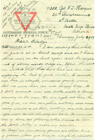
Document, Letters: July 1917 To Gladys from 7358 Pte William Thomas Harper, pre 1917
Original documents, envelopes, diet sheet,letters and photograph sent from abroad from William Thomas harper to Gladys Holmes, Byaduk 7358 Pte William Thomas Harper b. 1896, Byaduk, 8th Battalion - 24th Reinforcements, embarked on 19th February 1917 on HMAT A70 Ballarat. Killed in France on 3rd May 1918. Buried Outtersteene Communal Cemetery Extension, Bailleul France. Cousin to twin AV Harper and RS Harper. one of eight correspondents to Gladys Holmes, ByadukOriginal documents, part of 14 sets of correspondence to Gladys Holmes and local Byaduk residents from local servicemen during WW 1..001803.1: Envelope 001803.2 -.6R: Buff coloured paper, 6 sheets with YMCA logo on map of Australia and red triangle. 001803.7 - 7R: Envelope has a red 1d stamp with 20 SEP 17 black ink postmark and blue ink handwritten address with sender's details. 001803.8 - 8R: note and Diet sheet Week Aug 26 - Sep 2 1917 001803.9 - 9R: Small sepia photograph of physical training soldier, and reverse has handwritten notes001803.1: Envelope, addressed to Miss Gladys Holmes/Byaduk/Hamilton/Victoria/Australia. Postmark ...CAMP B.O. SALISBURY 10 UY 17 001803.2-.6R: Leeter: 24th Reinforcement/2nd Battn/Aust Imp Forces/Abroad/Sunday July 29.17 to Dear Gladys 001803.7- 7R: Envelope: Red id stamp with black postmark 11.45AM, 20 SEP 17, Address-Miss Gladys Holmes/Byaduk/Hamilton/Victoria/Australia. Sender: 7538 8th Batt. Reverse: Received 24th Nov 1917. 18.8.17/Use old/address/still/ 24.8 A.I.F. etc 001803.8- 8R: Note andDIET SHEET Week Aug 26 to Sep 2, Breakfast Dinner & Tea 1001803.9 - 9R: Photograph of physical trainer and reverse has 11 lines of informationwilliam thomas harper, gladys holmes, byaduk ww1, letter, photograph, envelope, a.i.f. -
 Warrnambool and District Historical Society Inc.
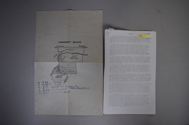
Map and Article, Dunmore, 1 1954 .2 1970
Both these items deal with the property of Dunmore, in the Macarthur/Hawkesdale/ Woolsthorpe area of Western Victoria. The first item is a sheet of paper with a map and details of the sale of portion of Dunmore in 1954. This is an original document. The second item is a history written by Stan Baulch of the property Dunmore from its establishment up to 1970. Dunmore was first established by Charles Hamilton MacKnight and two partners in 1842 and it was purchased by Samuel Baulch in 1893. After Samuel Baulch’s death the property was bequeathed to his three sons. One son, Stanley Baulch (1897-1980) took over the eastern portion which he named Rose Park. Stan Baulch was a member of the Warrnambool and District Historical Society and wrote several articles on aspects of his life and work, including this valuable article on the history of Dunmore. These items are of significance as they concern the estate of Dunmore in Western Victoria, an early and important property which is still farming land today under various owners. .1 This is a sheet of paper containing a map of the Dunmore property on one side and details of the sale of portion of Dunmore on the other side. The map has been annotated in handwritten black ink. The page has been folded twice. .2 This is an article typed on 12 foolscap pages. The typing is somewhat faint in places. ‘Dunmore’ Estate Dunmore baulch family, western district, victoria, dunmore estate, macarthur/hawkesdale, history of warrnambool -
 Warrnambool and District Historical Society Inc.
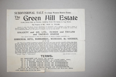
Documents (2), 1 1915 .1 1910
These documents come from a collection of material from the Baulch families of Dunmore and Rose Park estates in Western Victoria in the Macarthur district. They concern the sales of the Green Hills Estate (1910) and the Olangolah estate (1915) near Woolsthorpe. Both were offered for sale by the owner, Colin Tulloh. The properties bordered on Baulch property belonging to Stan Baulch (1897-1980) and hence this is the reason for their being included in Baulch estate material. These items are of minor interest and will be useful to researchers as they show the sizes and some owners of some early 20th century Western District properties. .1 A single sheet of white paper with a map or plan of a property and black printing. The paper is creased and torn slightly at the edges. 2 A single sheet of white paper with a map of a property on one side and black printing on the other. The paper is creased and torn at the edges. The Green Hills Estate Western District Estate ‘Olangolah’ western district estates, warrnambool, olongolah estate, green hills estate -
 Warrnambool and District Historical Society Inc.
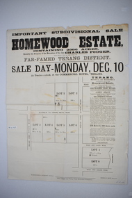
Original document, Advertising "Homewood Estate" Terang, 1886
This notice advertises the sale of the Homewood property near Glenormiston. The sale details state that the property is 2386 acres adjoining "The Sisters" the station of the Black Brothers. The property lies on the main metal road from Terang to Ellerslie, six miles from Terang. It has frontage to Pejark Marsh/drain. It was to be surveyed and sold in blocks of 250 to 300 acres with permanent water and well covered with grasses. The sale of the property followed the death of Charles Podger who died in 1886. On his death he left his wife Ann and six children.His worth was over 20000 pounds with 16000 pounds as real estate and 4300 pounds in personal propertyThe Agent for the sale was James Jellie, solicitors were Warrnambool firm Klingender and O'Mahony and the advertisement was printed by Thomas Smith Gas printing Works Warrnambool. This document has local interest and significance as an early sales of land in the district. The names of agents , solicitors and printers were wll known in the area and the property also a large holding. The Podger name is also well represented in the district to this day.Large white rectangular sheet of paper with black text . Major sale details in heavy black text at the top with descriptive text accompanying map of subdivision of the property on the left.The following names and details are contained within the document. Homewood Estate, Charles Podger, Commercial Hotel Terang, James Jellie Fenelon Mott Surveyor, Klingender & O'Mahony solicitors, Thos, Smith Gas Printing Koroit Street Warrnamboolcharles podger, homewood estate, klingender, o"mahony, kolora, the sisters, terang -
 Warrnambool and District Historical Society Inc.
Original Document, Map: Agricultural area of Ballangeich 1865, 1865
George Eddington arrived in Australia in 1839 and named and established property in 1841 calling the property Ballangeich after a Pass near his home town of Stirling in Scotland. It is situated 151 miles west of Melbourne and to the south of Mortlake and was originally part of the Mortlake shire, which was proclaimed 26th Jan 1864. Nearest streams are the Hopkins Riverand Lyall and Drysdale creek running through good agricultural land. This map relates to the breaking up of large runs which the Victorian government enabled through selection acts of the 1860's. The previously larger runs which were mainly cattle and sheep based were now more open to closer settlement and a greater variety in farming.The lots range in size from approximately 50 acres to around 600 acres.Some areas are set aside for reserves. By 1886 the population of Ballangeich had grown to around 600 with an hotel, three state schools and a church.Tri weekly coaches ran to Colac, Warrnambool and Camperdown providing access to supplies mail and communication. This map is typical of many which were produced in the 1860's in Victoria during a significant period of Victoria's and Warrnambool district history.Rectangular light card paper with black text showing allotments of land The area is coloured in green with scale at bottom right cornerAt the top: Plan of the Agricultural area of Ballangeich 1865 At the bottom left: Prepared by the Board of Lands & Works in accordance with the Amending Land Act 1865 Lands & Survey Office Melbourne 13th April 1865. With signaturehistory of warrnambool, ballangeich, land surveys victoria 1865, lands act 1865 victoria, ballangeich map 1865 -
 Warrnambool and District Historical Society Inc.
Document, Ella Webb, Warrnambool artist, Street Walks of Warrnambool, 2018
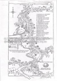
This is a tourist guide to Warrnambool produced by a local artist, Ella Webb, in conjunction with the Warrnambool and District Historical Society. It includes a sketch map showing the location of some points of interest – buildings and sites of historical interest, places of interest that are no longer existing, some natural features (mainly along the coast) and some information about incidents and people in the past. It is an attractive broadsheet that is a useful guide for visitors to Warrnambool. This sheet is of interest as a modern-day tourist map produced in an artistic fashion by a local Warrnambool artist.This is a single sheet of thick paper printed on both sides in green, brown, yellow and beige tonings. One side of the sheet has sketches of buildings and places of interest and printing and the other side has a sketch map of some of the main streets of Warrnambool and some of its attractions. -
 Warrnambool and District Historical Society Inc.
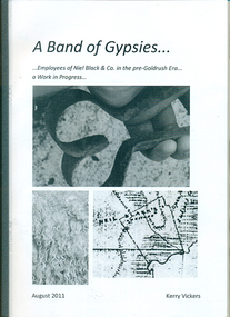
Booklet, A band of gypsies: employees of Niel Black & Co in the pre-goldrush era: a work in progress
Niel Black was an early settler in the Western District of Victoria who held large tracts of land including Glenormiston and The Sisters estates. Black was responsible for bringing many employees to the area. The employees' names, birthplace, arrival date, marriage partner/s, other employers are tabulated. An overview of Black's properties and conditions of the time is also included.This booklet documents those who came to the Western District to work for Niel Black prior to the goldfishes of the 1850s.In-house booklet with plastic sleeve outer cover, with black & white images of sheep shears, wool and a map of the Black property. All text is in black.emigration, employment, family history, early victorian squatters -
 Eltham District Historical Society Inc
Document - Folder, Shire of Eltham Historical Society, Heritage Week, 1982-1996
Various informational material for Heritage Week themes by year along with Shire of Eltham Historical Society forms and copies of activities Includes 1989 self guided tour with map of 36 historical locations provided as part of the Shire of Eltham Historical Soiciety's activities for Heritage Week 1989 and also 1983 (recreated from display materials)eltham heritage walk, heritage week, heritage week 1989, shire of eltham historical society -
 Eltham District Historical Society Inc
Document - Property Binder, Eltham Town Square, Commercial Place, Eltham
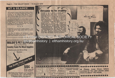
1. Dreams to be reality, The Valley Voice, 15 August 1979, p2 - announcement of proposed town square of 1800 square metres of shop area and open courtyard to be sited in the carpark between Arthur Street and Pryor street. The plans also included tree-lined walkways from both Arthur Street and a pededstrian footbridge across Main Road leading to aregular open-air market and tavern. Shop owners facing Main Road were to be encouraged to turn their businesses towards the square. On reverse side - 'General' Marshall and his troops; Valley votes in five new faces, The Valley Voice, 15 August 1979, p1 - picture showing newly elected Cr Robert Marshall 2. Square plan on display, Diamond Valley News, Tuesday, June 23, 1981, p1 - Council's prefered proposal on display to the public. On same page a story about the son of Cr Bob Manuell being attacked on the train from the city. On reverse side - Helping people - here and abroad by Marguerite Marshall, Diamond Valley News, Tuesday, June 23, 1981, p2 - about Keith Ryall of Zig Zag Road, the Apex international councillor for Australia 3. Plan: Eltham Town Centre property Acquisition, Shire of Eltham March 1994businesses, arthur street, bible street, commercial place, dudley street, eltham, franklins supermarket, luck street, main road, map, mcewans, pryor street, safeway supermarket, apex club, bronwyn ryall, keith ryall, zig zag road, cr bob manuell, cr robert allen, det sgt noel murphy, eltham chamber of commerce, eltham police, eltham shire council, eltham town square, lorraine manuell, pauline toner mp, robert manuell, rodney roscholler, shire planner, vicrail, elections, h&j white general store, hurstbridge, leslie bowker, main street, mrs marshall, pam lawson, robert marshall, rosemary tovey, central park, comfort station, eltham little theatre, montmorency, public toilets, rotex cinema, were street -
 Eltham District Historical Society Inc
Document - Folder, Eltham Cemetery, Mt Pleasant Road, Eltham, Vic, 2009-2010
Initially collated by Harry Gilham regarding the history of the cemetery and various developments and artworksarthur munday, cemetery gates, chappel terrace, eltham cemetery, gravedigger, james orford, justus jorgensen, lena cooper skipper, lily agnes jorgensen, mervyn g. skipper, svend erik kroyer-pedersen, vaults -
 Eltham District Historical Society Inc
Document - Series Listing, Fraser Faithfull et al, Series 33: Shire Aerial Photograph Collection, 2000
Series consists of 39 aerial photographs and photo maps of the Shire and environs. A separate Item List exists (created on MS Excel spreadsheet), please refer to the attached pagesshire of eltham archives, series listing -
 Eltham District Historical Society Inc
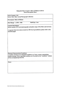
Document - Folder, Jarrold Cottage (White Cloud), 701 Main Road, Eltham, c.2002-c.2014
Information pertaining to the former Jarrold Cottage built in the early 1850s which has been in the Skipper family since 1944 Contents: 1 Journal Article: Jarrold Cottage; This quaint house survived fire and flood, Eltham Shire, newsletter c.2002, p10-11 2. Newspaper article: Cottage of 1800s, 100 Years of News Special Edition, (Leader Newspapers), August 27, 1997, p36 3. Jarrold Cottage (7), extract from tourist drive map publication (unknown) 4. Journal Article: Eltham . . . then and now, written by Judy Lewis, Eltham Town Community News, pp10-11, date unknown with hand written comments/corrections by Diana Bassett-Smith. Features Jarrold Cottage, Southernwood and Walter Withers and the former CBA Bank building. 5. Artice: Jarrold Cottage or White Cloud Cottage, compiled by Harry Gilham (2 pages)Folder of information on Jarrold Cottage consisting of 5 A4 photocopies and one A3 (colour) two page journalbootmakers cottage, cba bank, eltham, jarrold cottage, main road, southernwood, walter withers, white cloud cottage -
 Eltham District Historical Society Inc
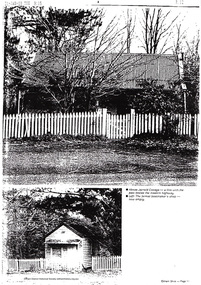
Document - Flyer, Greg Johnson et al, Say No to this Ring Road, 9 Sep 1999
anti ring road organisation (arro), dr paul mees, greg johnson, kennett government, liberal government, melbourne, metropolitan orbital transport corridor, metropolitan ring road, vicroads, victoria, wayne phillips m.p., map -
 Eltham District Historical Society Inc
Document - Property Binder, 1203 Main Road, Eltham
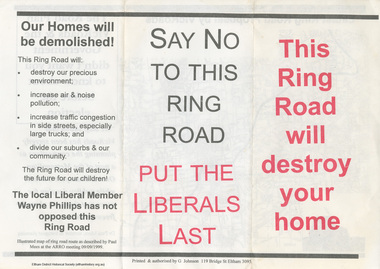
Display panel: Map of Coleman's house location; 1904 photograph of Coleman house with Tom Newton, Mary Coleman (later Dowes) Mary Ann Coleman (nee Burke, mother of Jack Coleman, George Coleman, Mary Coleman), George Coleman, John (Jock) Coleman (father of John Coleman junior married to Margaret Coleman nee Dare); 1971 photograph of part of Coleman house. Typed document, compiled by Dorothy Peatling, Objection to Application 980731 Proposal for 6 units at 1203 Main Road Eltham, stories from Mrs Thomas, Ken Gaston, Frank Martin, Vicky Weston (nee Coleman), Frank Burgoyne, Heather Bakos, Mrs Dansey, and other historical information. Typed document, by Margaret Jennings, Objection to Application 980731 Proposal for 6 units at 1203 Main Road Eltham, history of site. Typed document, by Eltham District Historical Society, history of site, summary of interviews from Dorothy Peatling objection.main road, eltham, property, houses, coleman house, coleman crescent, mary coleman, mary dowes, mary ann coleman, mary ann burke, jack coleman, george coleman, john coleman, jock coleman, margaret coleman, margaret dare, dorothy peatling, mrs thomas, ken gaston, frank martin, vicky weston, vicky coleman, frank burgoyne, heather bakos, mrs dansey, wattletree road, edendale farm, orchard avenue eltham north, diamond creek, christmas creek, cobb and co royal mail -
 Eltham District Historical Society Inc
Document - Property Binder, 725 Main Road, Eltham
Photocopy (A4): Map hand drawn by Peter Grier, brother to Wendy Wilson, commissioned by jeweler, Michael Wilson showing his business 'Eltham Goldsmithery' c.1979-1981. Newspaper article: Art and design venue, Diamond Valley News, August 14, 1996, p14 where it is announced that the business has been approved as an outlet for Italian design house Alessi. In same article a reference to an exhibition by the deceased 'Twenty Melbourne Painters' hanging at the Victorian Artists Society Gallery and former and present day connections with Eltham area including Angela Abbott, Peter Glass, Alan Martin, Lesley Martin, Max Meldrum, Percy Leason, Alice Bale, Walter Withers, Margery Withers, Richard Mccann. (On p13 letters to the Editor about protesting against inappropriate development and the Commissioners plans for future elected Nillumbik Council structural representation). Advertisement 19 June 2013, Michael Wilson diamond jewellers. Advertising flier 23 November 2020, Michael Wilson.main road, eltham, property, houses, shops, businesses, michael wilson jewellers, peter grier, map, eltham goldsmithery, artisans minting, cafe de chin, diamond valley railway, eltham barrel, eltham clinic, eltham collegeeltham hotel, eltham community centre, eltham gallery, eltham railway station, eltham shopping centre, eltham town park, gallery 4, john mills pottery, living and learning centre, montsalvatcountry arts store, once upon a time land, shillinglaw cottagewiregrass gallery, wingrove park, michael wilson diamond jewellers -
 Eltham District Historical Society Inc
Document - Property Binder, 801 Main Road, Eltham
1. Plan: Henry Dendy's Eltham Land 1857-1867: showing Diamond Creek, Bridge Street, Maria Street now Main Road, John Street, Pitt Street, St Margaret's Church 1861, and Eltham Community Centre 1987. 2. Photocopy extract from "Henry Dendy and his emigrants" by L A Schumer, re Portions 12 and 13, Parish of Nillumbik. 3. The President and Councillors of the Shire of Eltham request the pleasure of ____ at the Official Opening of the Eltham Community Centre, Cnr Main Road and Pitt Street, Eltham by the Honorable R.J. Hamer E.D., M.P., Premier of Victoria on Saturday, 22nd April, 1978 at 3.30pm 4. Souvenir Program, Opening of Eltham Community Centre 22 April 1975. 5. Invitation to attend Official Opening of Eltham Community Centre by R J Hamer, Premier of Victoria, 22 April 1975. 6. Flier for Eltham Reception and Conference Centre, photographs of interiors during events. 7. Newspaper article: Eltham buries present for the future, Diamond Valley News 19 November 1985 Eltham, photograph of burying time capsule outside Eltham Community Centre, photograph of Bill Baker and Sid Brown outside old blacksmith shop the original site of Eltham town centre. 8. Letter Peter Butler Shire of Eltham to Eltham District Historical Society, 6 July 1987, detailing process for naming of the halls at the Eltham Community Centre.6 July 1987. 9. Plan of Main Road Eltham - it depicts buildings and occupiers from Pitt Street to Luck Street in the first half of the 20th century. This plan was compiled as a joint efforts by members of the Shire of Eltham Historical Society at a general meeting in Eltham during the 1980s. Newspaper article: Swimming pool and community centre receive major revamps, Diamond Valley Leader, 21 October 2015.main road, eltham, eltham community centre, henry dendy, eltham reception and conference centre, bill baker, sidney brown blacksmith, tme capsule, arthur street, babe taylor house, bakery, boarding house, bradley house, bridge street, brown blacksmith, burgoyne's shop, cockcrofts store, commercial bank of australasia, david lyon house, davis, dr cordner, dr hall, dudley street, eltham hotel, eltham obelisk, eltham war memorial, garnet burges, graham, hawker, henry street, john lyon, len perron, luck street, lyons garage, map, mechanics insitute, monteith house, mrs morris shop, our lady help of christian’s primary school, panther place, pitt street, prior street, shillinglaw cottage, shops, stones mixed shop, websters house, wesleyan methodist church, york street -
 Eltham District Historical Society Inc
Document - Property Binder, 810 Main Road, Eltham
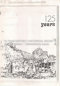
Photocopy publication: Eltham Methodist Church One Hundred and Twenty-Five Years 1850-1975, Chris Allan editor. History of early Eltham, railway, schools, churches by A Bird. Map of Eltham with sites of significant buildings. Maps church site. Plan of church. Reminiscences by Edna Bill, Val Gangell, Don Brown. Notes by Ken Eckersall, Peter Gray, Ron Hubery. Newspaper article: Lessons in history, Diamond Valley News, 2 August 2000. Newspaper article: Parents stop teachers, Diamond Valley News, 2 August 2000, State-wide preschool teachers strike and Hurstbridge pre-school.main road, eltham, eltham methodist church, eltham uniting church, josiah holloway, hurstbridge pre-school, kinglake national park, churches -
 Eltham District Historical Society Inc
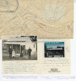
Document - Folder, Survey Maps and Technical Drawings
... ) Survey Maps and Technical Drawings Document Folder ...alan gardiner collection, maps -
 Eltham District Historical Society Inc
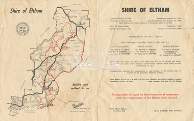
Document - Pamphlet, Shire of Eltham, December 1962
This pamphlet was issued for the information of ratepayers, with the compliments of the Eltham Shire Council. Subjects of information included: Shire statistics and history Members of Council 1962-63 Bushfires Dogs Rates Works Programme Shire Offices Town Planning Map of Shire of Eltham with Bushfire area outlined in redbushfires, charis pelling, charles m. a. pelling, councillors, dogs, eric dudley butler, eric percival harmer, franklin william nankervis, george l. cresp, leslie christopher docksey, m.b. watson, map, maxwell alexander spence, rates, raymond clive duncan, rodney d. quin, shire of eltham, shire offices, town planning, works programme