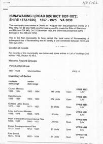
Showing 1182 items matching "municipality"
-
 City of Moorabbin Historical Society (Operating the Box Cottage Museum)
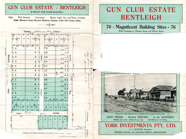
Flyer - Gun Club Estate, Highett, 1927
The train line from the city to Frankston was electrified in 1922 which intensified the sale in the municipality of Moorabbin, particularly land which was in the vicinity of the railway stations. York Investments Pty Ltd purchased the land in 1927.Example of the progress of the Municipality of MoorabbinAdvertising flyer for auction of real estate sales - plan of building blocks for saleGun Club Estate, Bentleigh 76 housing blocks - York Investments Pty Ltdthomas street, erica avenue, brewer road, grace street, victor road, melbourne gun club, benteligh, real estate -
 Lilydale RSL Sub Branch
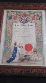
Certificate - Framed Certificate of Thanks and Appreciation, 24/5/1918
Framed Certificate in carved wooden frame headed "In Freedom's Cause"Shire of Upper Yarra ---- The President and Councillors and Ratepayers of the Shire of Upper Yarra Hereby place on record their thanks and Appreciation for the Conduct of Leslie Raymond Jack who served his King and Country in the Great War. In Witness Whereof the Corporate Seal of the Municipality is hereto attached in the presence of. -
 South Gippsland Shire Council
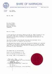
Letter, 1988
Typed letter from Shire of Narracan to Shire of Woorayl dated 19th May 1988. Congratulations to the shire of reaching 100 years as a municipality. Sealed with Common Seal and signed by the shire president, councillor ans shire secretary. Note: Item approved for deaccession August 2023. SGSC will now follow deaccession procedures as outlined in the Arts and Civic Memorabilia Collection Policy - https://www.southgippsland.vic.gov.au/downloads/file/2763/arts_and_artefacts_collection_policy_c69. -
 Bayside Gallery - Bayside City Council Art & Heritage Collection
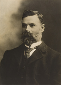
Photograph - sepia photograph, Councillor R. Cheeseman
Richard Cheeseman (1855-1916) was a councillor for the East Ward at Brighton Council for 16 years.councillor, brighton, local goverment, municipality, portrait, bayside, east ward, richard cheeseman, cr. r. cheeseman -
 Bayside Gallery - Bayside City Council Art & Heritage Collection
Photograph - sepia photograph, Councillor A. R. Horton, Mayor of Brighton 1930-31, c. 1931
Arthur Robert Horton (c.1892-1975) was a representative for the North Ward in Brighton Council from 1926-1935, elected Mayor in 1930-31. He was a solicitor at the firm Proudfoot, Horton. & Cox, until he retired in 1947.portrait, councillor, mayor, brighton, municipality, north ward, arthur robert horton, cr. a.r. horton, solicitor -
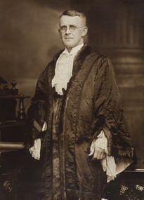
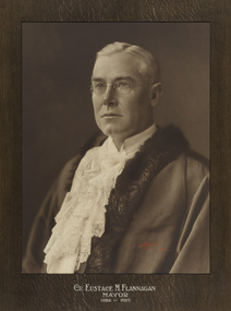 Bayside Gallery - Bayside City Council Art & Heritage Collection
Photograph - gelatin silver photograph, Lafayette, Councillor Eustace M. Flannagan, Mayor of Brighton 1926-27, c. 1927
Eustace Menotti Flannagan (1868-1950) was a solicitor and a representative in the South Ward in Brighton Council for 16 years, retiring in 1932. He was elected Mayor of Brighton 1926-27. portrait, councillor, mayor, brighton, municipality, south ward, cr. e.m. flannagan, eustace menotti flannagan, mayoral robes -
 Greensborough Historical Society
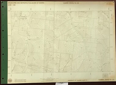
Map, Melbourne and Metropolitan Board of Works. Survey Division, MMBW, Yarra 2500 / 16.22. Research, 1979_05
Melbourne and Metropolitan Board of Works. Yarra 2500 [base map] 16-22. Research. Parish of Nillumbik 3310. Municipalities of Diamond Valley 257 and Eltham 238. Prominent streets include: Orme Road and Allendale Road. MMBW Map in 1:2500 [scale] series. Cream parchment with green tape reinforcing on edges and punched holes on left edge.mmbw, melbourne and metropolitan board of works, shire of diamond valley, diamond creek - maps -
 Greensborough Historical Society
Map, Melbourne and Metropolitan Board of Works. Survey Division, MMBW, Yarra 2500 / 15.25. Yarrambat, Black Gully Road, 1978_07
Melbourne and Metropolitan Board of Works. Yarra 2500 [base map] 15.25. Yarrambat, Black Gully Road. Municipality of Diamond Valley 257. Prominent streets include: Black Gully Road, Ironbark Road and Murray Road. MMBW Map in 1:2500 [scale] series. Cream parchment with green tape reinforcing on edges and punched holes on left edge.mmbw, melbourne and metropolitan board of works, shire of diamond valley, yarrambat - maps -
 Glen Eira Historical Society
Book - Royal Visit 1901 - HRH The Duke of Cornwall and York
This file contains three items about the visit of Prince George Duke of Cornwall and York (later Prince of Wales, later Geroge V) to Victoria in 1901: 1/A book ‘Addresses to (His Royal Highness) HRH The Duke of Cornwall and York and to His Excellency the Governor-General the Earl of Hopetown from the Municipalities of Victoria' containing copies of the addresses from the municipalities to George and the Governor-General on the inauguration of the Commonwealth of Australia, and the replies of George and the Governor General. The book also contains individual cards on each municipality, including the Shire of Caulfield. The cards contain information such as date of incorporation and population, and the signatures of the Mayors, Councillors and Town Clerks of the cities, towns and boroughs, and the signatures of the Presidents, Councillors and Secretaries of the Shires. The book also contains the signatures of the President, executive committee and secretary of the Municipal Association of Victoria. 2/A research note by Amy MacKintosh on the information on Caulfield Shire contained within the book. 3/A research note by Amy MacKintosh on the circumstances of George’s visit to Australia.royal visits, federation (1901), local government, caulfield, george v, george duke of cornwall and york, mary duchess of cornwall and york, earl of hopetoun, hope john earl of hopetoun, shire of caulfield, governor general, hopetoun, hopetoun lady, caulfield historical society, akhurst a. c., pennington harold, jowett f., slaney h., kirkham c. f., sharp t. c., riddell w. t. c., lempriere john t., wood f. g., bayston w. s., lloyd c., phillips r. l., long j. -
 Bendigo Historical Society Inc.
Newspaper - BENDIGO ADVERTISER OCTOBER 8, 1970 ARTICLE HUNTLY DEFERS DECISION ON BENDIGO TRUST, 08/10/1970
Bendigo Advertiser October 8, 1970 Newspaper Article Huntly Defers Decision on Bendigo Trust Cr. K.A Read suggests that too much power is being given to an organisation based solely in Bendigo when its task is to coordinate all items and laces of interest in and around Bendigo. Cr read was disgruntled that there was only one representative from each of the surrounding municipalities on the Bendigo Trust committee but many representatives from Bendigo.bendigo, history, formation bendigo trust -
Ringwood and District Historical Society
Pamphlet, City of Ringwood, Notice Paper for Ringwood City Council - October 1974, 22-Oct-74
Notice paper for the special jubilee meeting of the Ringwood City Council and Citizenship ceremony to be held on Tuesday 22-Oct-1974 at 7.30 p.m. commemorating the 50th anniversary of the Municipality's severance from the Shire of Lillydale 22-Oct-1924.Notice Paper for Ringwood City Council, comprising one buff coloured bifold pamphlet with brown and gold printing. +Additional Keywords: Miles, A.T. (Mayor) -
 Greensborough Historical Society
Map, Melbourne and Metropolitan Board of Works. Survey Division, MMBW, Yarra 2500 / 12.23. Janefield and Kangaroo Point, 1977_10
Melbourne and Metropolitan Board of Works. Yarra 2500 [base map] 12-23, Municipalities of Whittlesea 239 and Diamond Valley 257. No streets marked on this map. Includes Plenty River, Kangaroo Point, Janefield Colony and Janefield Reserve.MMBW Map in 1:2500 [scale] series. Cream parchment with green tape reinforcing on edges and punched holes on left edge.mmbw, melbourne and metropolitan board of works, shire of diamond valley, plenty - maps -
 Greensborough Historical Society
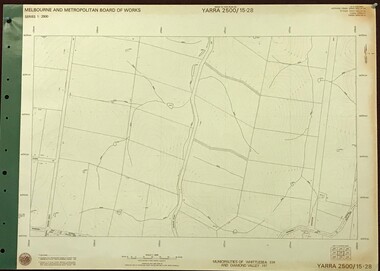
Map, Melbourne and Metropolitan Board of Works. Survey Division, MMBW, Yarra 2500 / 15.28. Yarrambat, 1977_10
Melbourne and Metropolitan Board of Works. Yarra 2500 [base map] 15-28. Yarrambat. Municipalities of Diamond Valley 257 and Whittlesea 239. Prominent streets include: Edward Henty Avenue, Charles Sturt Drive and Creighton Way. MMBW Map in 1:2500 [scale] series. Cream parchment with green tape reinforcing on edges and punched holes on left edge.mmbw, melbourne and metropolitan board of works, shire of diamond valley, yarrambat - maps -
 Greensborough Historical Society
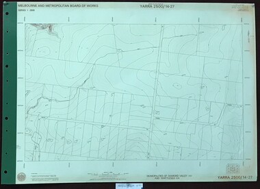
Map, Melbourne and Metropolitan Board of Works. Survey Division, MMBW, Yarra 2500 / 14.27. Yarrambat, Youngs Road, 1977_09
Melbourne and Metropolitan Board of Works. Yarra 2500 [base map] 14.27. Yarrambat, Youngs Road. Municipalities of Diamond Valley 257 and Whittlesea 239. Prominent streets include: Youngs Road, Ashley Road and Yan Yean Road. MMBW Map in 1:2500 [scale] series. Cream parchment with green tape reinforcing on edges and punched holes on left edge.mmbw, melbourne and metropolitan board of works, shire of diamond valley, whttlesea, yarrambat - maps -
 Greensborough Historical Society
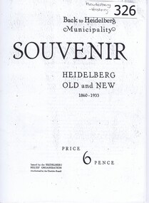
Booklet, Souvenir : Heidelberg Old and New 1860-1933, 1860-1933
Originally written in 1933 for the 'Shire of Heidelberg Relief Organisation' this booklet gives a brief history of some areas within the municipality, including St Helena and Greensborough. A list of some pioneers is included. Contains advertisements from local businesses.A snapshot of the Heidelberg municipality in the 1930s.Photocopy of booklet. 32 pages, black and white illustrations.heidelberg, greensborough, st helena -
Port Melbourne Historical & Preservation Society
Flyer - Port Melbourne Festival, Jan 1998
Produced by the Port Melbourne Festival Committee in conjunction with the Bay Street Traders and Circus Oz and distributed throughout the municipality. (From 1996 to 1999 Circus Oz was heavily involved with the Festival, which took place this year in Bay Street.)Preliminary promotional flyer for Port Melbourne Festival, 1 March 1998arts and entertainment, celebrations fetes and exhibitions, port melbourne festival committee, circus oz -
Port Melbourne Historical & Preservation Society
Programme, Port Melbourne Festival Summer Circus Celebration, Feb 1996
Produced by the Port Melbourne Festival Committee in conjunction with the Bay Street Traders and Circus Oz and distributed throughout the municipality. (From 1996 to 1999 Circus Oz was heavily involved with the Festival, which took place this year at Edwards Park.)Program for Port Melbourne Festival Summer Circus Celebration, 24/25 February 1996: A4, black on cream.arts and entertainment, celebrations fetes and exhibitions, port melbourne festival committee, circus oz -
Port Melbourne Historical & Preservation Society
Programme, 1997 Summer Circus Celebration, Feb 1997
Produced by the Port Melbourne Festival Committee in conjunction with the Bay Street Traders and Circus Oz and distributed throughout the municipality. (From 1996 to 1999 Circus Oz was heavily involved with the Festival, which took place this year at Edwards Park.)Program for Port Melbourne Festival Summer Circus Celebration, 23/34 February 1997: DL, printed in pink and blue.arts and entertainment, celebrations fetes and exhibitions, port melbourne festival committee, circus oz -
Port Melbourne Historical & Preservation Society
Programme, 1998 Port Melbourne Festival, Feb 1998
Produced by the Port Melbourne Festival Committee in conjunction with the Bay Street Traders and Circus Oz and distributed throughout the municipality. (From 1996 to 1999 Circus Oz was heavily involved with the Festival, which took place this year in Bay Street.)Program for Port Melbourne Festival Summer Circus Celebration, 1 March 1998: A5, full colour,12 pp (two copies)arts and entertainment, celebrations fetes and exhibitions, port melbourne festival committee, circus oz -
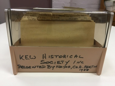
 Kew Historical Society Inc
Photograph - Aerial View of East Kew, c.1930
The Municipality of Kew was proclaimed in 1860. This eastern section of Kew was settled from the 1850s with all land sold in the vicinity by 1851. The original large estates were further subdivided in the second half of the 19th and in the first decades of the 20th centuries.Early aerial photograph of KewFramed aerial photograph of that part of Kew in which is located Genazzano FCJ, the Kew Reservoir, and the retail nurseries of Bennett’s and Rimington's.genazzano fcj, kew reservoir, rimington's nurseries, bennett's nursery, cotham road, mont victor road (kew) -
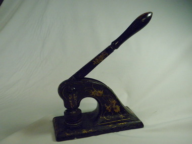 Numurkah & District Historical Society
Functional object - Numurkah Shire Common Seal
THE CONSTITUTION OF MUNICIPALITIES GENERALLY. DIVISION 1. INCORPORATION AND GOVERNMENT OF MUNICIPALITIES AND BOUNDARIES OF DISTRICTS. 8. (1) The inhabitants of every shire borough town and city inhabitants of for the time being subject to the provisions of this Act shall, under corporation. the name of the president councillors and ratepayers of such shire N°-5203 «• '• the mayor councillors and burgesses of such borough the mayor councillors and burgesses of such town or the mayor councillors and citizens of such city as the case may be, be a body corporate with perpetual succession and a common seal with power to break alter and change the same from time to time with the approval of the Governor in Council and shall by such name be capable in law of suing and being sued, of purchasing holding and alienating land, and of doing and suffering subject to the provisions of this Act all such other acts and things as bodies corporate may by law do and suffer. (2) The corporation of ******** Shire Common Seal 54. The common seal of the municipality shall be kept in a box having two locks, of one of which locks the chairman of the municipality shall have a key and of the other of which locks the key shall be kept by the municipal clerk; and the corporate seal shall not be affixed to any document unless the chairman of the municipality and one other member of the council or in the absence of such chairman unless two councillors be present. 91. The Council’s Common Seal (1) The Chief Executive Officer must ensure the security of the Council's common seal at all times. (2) The Council's common seal may only be used on the authority of the Council given either generally or specifically and every document to which the seal is affixed must be signed by the Chief Executive Officer or a senior officer authorised by him or her. (3) Any person who uses the Council's common seal without authority is guilty of an offence. (4) Any person who uses any replica of the council’s seal without authority is guilty of an offence. The Numurkah Shire was amalgamated into the Moira Shire and the seal now redundant. This is the only Numurkah Shire Common Seal in existence.local government, common seal, numurkah -
 Flagstaff Hill Maritime Museum and Village
Document - Framed Poster, Borough of Warrnambool, Victoria, Australia, after 30/06/1875
This document, also referred to as a word picture or Tablet, is framed in glass and timber with gilt trim, is handwritten with colour highlights. The penned letters rest on ruled guide lines, decorated where the lines intersect. The writing gives a description of the state of Borough of Warrnambool around 1875; its location, the area it covers, its population, Harbour and facilities, public buildings and institutions, imports and exports, financial worth, number of houses, connection with other areas of the Colony. A possible reason and origin for the document is found in an article ‘Link with US Exhibition’ from the Warrnambool Standard of December 19, 1981, written by local historian Bruce Morris. The writer mentions that the Warrnambool Borough Council met on 15th June 1875 and recorded a letter from G.C. Levey , secretary to the Melbourne group of commissioners representing the Colony, and Victoria in particular, for the Philadelphia Centennial Exhibition of 1876. The letter asks Council to provide “statistics as to the population, social condition and commercial and industrial state of the district in and around Warrnambool.” A sub committee was formed for the project. The Mayor, Cr. Thomas King, wrote and signed a Report, presented to the council on July 14, 1875, in which “The Committee … begs to recommend that a Tablet be prepared setting for the particulars respecting the following matters relating to the Borough”. The matters included area, population, annual income, churches, schools, other public buildings, societies and companies, general description of houses erected, and returns of exports and imports for 1874. The minutes note that the Report was adopted. The article above also notes the opinion of Warrnambool printers who have examined the document; it is almost certainly to be an old lithograph, which means there could be several copies. It is possible that there may be a copy in Melbourne and another in Philadelphia. It is interesting to note that (1) the quoted location co-ordinates are for an “Unnamed Road, Packsaddle NSW 2880, Australia”, and that the DMS co-ordinates for Warrnambool’s Council Offices differ, being 38.23.9.12 South, 142.28.52.887. (2) the date for “Exports and Imports for the Year Ending 30th June 1875” is different to the period mentioned by Cr. King in the sub committee’s Report of recommendation “returns of exports and imports for 1874”. The information required to have the figures for the end of June 1875 would need to have been compiled very quickly for the Tablet to be ready for the opening of the Philadelphia Exhibition on 10 May 1876. The document/certificate shows the following – - - - - - - - - - - - - - - -- - - - - - - - - - - - - - -- - - - - - - - - - - - - - -- - - - - - - - - - - - - - - “Victoria Australia, Borough of Warrnambool. Latitude, 30.24.50 South, Longitude 142.32 East The Principal Port in the Western District of the Colony and the Centre of its Choicest Agricultural Lands. Established a Municipality in 1855, and Created a Borough 1863. Population in 1875 4,500. Warrnambool is the nearest Port to Melbourne on the Western Seaboard, being about 160 miles distant. Coaches run to and from the Metropolis daily, in connexion [connection] with the Railway of Geelong and Steamers belonging to Local Companies sail between Melbourne, Warrnambool, Belfast [renamed Port Fairy], and Portland several times weekly. The Harbour is known as Lady Bay, and is partially protected by a reef of rocks stretching from the mouth of the Hopkins River. The formation of a Breakwater has been decided upon by the Government, to extend 600 yards, at an estimated cost of £100,000. There are two substantial Jetties, one of 800 and the other of 600 feet in length. The former is connected with the Town by means of a Tramroad, along which Goods, inwards & outwards, are conveyed, & the latter has been constructed solely for the purpose of facilitating the transit of material for the formation of the Breakwater. In addition to the trade of the Borough and District, the principal Townships up country receive their supplies from Melbourne and ship their exports through Warrnambool. Potatoes form the staple produce of the district, and the richness of the soil can be estimated by the fact that the Government Statistics for 1875 give as the average yield a return of Seven Tons to the acre. Several thousand acres between Warrnambool and Tower Hill are now being laid down in Potatoes by Tenants who have leased the lands at rates up to £5 per acre for the season 1875-6. Wool, Tallow, hides &c are also largely exported, while the shipments of all descriptions of Farm Produce are annually increasing. Area of Borough, 3362 Acres. Net Annual Value £27,000. Annual Revenue £5,500. Number of Houses in Borough 800. Public Buildings and Institutions Churches. Church of England, Roman Catholic, Presbyterian, Wesleyan, Congregational and Baptist. Schools. Three State Schools, average attendance nearly 1000. New Building in course of erection. Several private establishments. Banks. Bank of Australasia, Bank of Victoria, National Bank, Colonial Bank and Savings Bank. Public Buildings. Court house, Custom house, Post & Telegraph Offices, Survey & Land Offices, Shire £, Town Hall, Mechanics Institute, Volunteer Orderly Room, Odd Fellows Hall, Hospital & Benevolent Asylum, Temperance Hall &c. Companies & Societies. Steam Navigation Co, Woolen Mill Co, Gas Co, Racing Club, Amateur Turf Club, Agricultural Society, Farmers’ Club, Cricket Club, Anglers’ Society, Building Society, Freemasons Odd Fellows, Foresters, Druids, Hibernians. Protestant Alliance, Rechabites, Sons of Temperance, &c, Fire Brigade &c. --- Exports and Imports for the Year Ending 30th June 1875 –-- --Exports Total Tonnage 27,800 (Calculated at the Current Warrnambool Market Prices) Potatoes Wool Wheat Barley Hides Skins Fowls Butter Cheese Eggs Tallow Leather Ale Pigs Sheep Sundries --Imports 13,000 Tons Of the Estimated Value of £520,000 Total Tonnage of Exports and Imports 40m900 Tons, Value £806,627 Passenger Travels, to ad from Warrnambool during year, 10,000 persons Revenue from all sources paid through Warrnambool Sub Treasury From 1860 to June 1875 £1, 292, 300 Thomas King [signed] Mayor Henry T Read [signed] Town Clerk” - - - - - - - - - - - - - - -- - - - - - - - - - - - - - -- - - - - - - - - - - - - - -- - - - - - - - - - - - - - - The document is of historical, social, economic and local significance in that it summarises activities, business, community, trade, travel and government at a point in time in Warrnambool’s history – 30th June 1875.Document, also referred to as a ‘word picture’ or ‘tablet’. Document is framed in glass and timber with gilt trim, handwritten with colour highlights. The penned letters rest on ruled guide lines, decorated where the lines intersect. Document outlines the establishment of Warrnambool as a Municipality in 1855 and Borough in 1863, with a population of 4,500 in 1875. It states geographic location, public buildings and institutions, harbor facilities and imports and exports for the year ending 30th June 1875. Two signatures "Thomas King" Mayor and "Henry T Read" Town Clerk. It shows the Coat of Arms of the Borough of Warrnambool.Signatures - "Thomas King" Mayor and "Henry T Read" Town Clerk. Warrnambool Coat of Arms; “British Coat of Arms, above sailing vessel and sheaf of wheat in sun, motto “By these we flourish” and around circumference “Borough of Warrnambool 1855”flagstaff hill, warrnambool, shipwrecked coast, flagstaff hill maritime museum, maritime museum, shipwreck coast, flagstaff hill maritime village, great ocean road, borough of warrnambool, municipality of warrnambool, document borough of warrnambool 1875, word picture of warrnambool 1875, tablet of borough of warrnambool 1875, statistics borough of warrnambool 1875, lithograph borough of warrnambool 1875, coat of arms warrnambool, warrnambool city motto – in these we flourish, establishment of warrnambool, warrnambool history, thomas king mayor of warrnambool, henry t read town clerk of warrnambool, warrnambool breakwater, warrnambool jetty, warrnambool imports and exports 1875, warrnambool agriculture 1875, warrnambool business 1875, warrnambool population 1875, centennial exhibition philadelphia 1876, framed certificate -
 Greensborough Historical Society
Map, Melbourne and Metropolitan Board of Works. Survey Division, MMBW, Yarra 2500 / 17.26. Hurstbridge, 1978_01
Melbourne and Metropolitan Board of Works. Yarra 2500 [base map] 17-26. Hurstbridge. Municipalities of Diamond Valley 257 and Eltham 238. Prominent streets include: Flat Rock Road and Heather Avenue. Includes Hurstbridge Railway Station.MMBW Map in 1:2500 [scale] series. Cream parchment with green tape reinforcing on edges and punched holes on left edge.mmbw, melbourne and metropolitan board of works, shire of diamond valley, hurstbridge - maps -
 Greensborough Historical Society
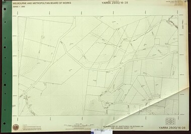
Map, Melbourne and Metropolitan Board of Works. Survey Division, MMBW, Yarra 2500 / 16.28. East of Hurstbridge, 1977_10
Melbourne and Metropolitan Board of Works. Yarra 2500 [base map] 16.28. East of Hurstbridge. Municipalities of Whittlesea 239, Eltham 238 and Diamond Valley 257. Prominent streets include: Boyds Road, Bannons Lane and Wattle Tree Road. MMBW Map in 1:2500 [scale] series. Cream parchment with green tape reinforcing on edges and punched holes on left edge.mmbw, melbourne and metropolitan board of works, shire of diamond valley -
 Greensborough Historical Society
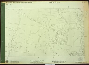
Map, Melbourne and Metropolitan Board of Works. Survey Division, MMBW, Yarra 2500 / 16.27. Hurstbridge, 1977_10
Melbourne and Metropolitan Board of Works. Yarra 2500 [base map] 16.27. Hurstbridge. Parish of Greensborough 2724. Municipalities of Whittlesea 239 and Diamond Valley 257. Prominent streets include: Haleys Gully Road, Kendalls Lane and Bingley Avenue. MMBW Map in 1:2500 [scale] series. Cream parchment with green tape reinforcing on edges and punched holes on left edge.mmbw, melbourne and metropolitan board of works, shire of diamond valley, shire of whittlesea, hurstbridge - maps -
 Greensborough Historical Society
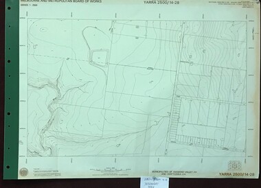
Map, Melbourne and Metropolitan Board of Works. Survey Division, MMBW, Yarra 2500 / 14.28. Yarrambat Park, 1977_09
Melbourne and Metropolitan Board of Works. Yarra 2500 [base map] 14.28. Yarrambat Park. Municipalities of Diamond Valley 257 and Whittlesea 239. Prominent streets include: Bannons Road and Yan Yean Road. Features include the Plenty River.MMBW Map in 1:2500 [scale] series. Cream parchment with green tape reinforcing on edges and punched holes on left edge.mmbw, melbourne and metropolitan board of works, shire of diamond valley, whttlesea, yarrambat - maps -
 Whitehorse Historical Society Inc.
Document - Inventory, Nunawading Municipal Records Deposited with Public Records Office of Victoria (PROV)
Inventory of municipal records for the Nunawading Road District (1857-1872), Shire (1872-1925) and City (1945-1994); Shire of Blackburn and Mitcham (1925-1945) and Box Hill Borough (1925-1927) and City (1925-1994)8 A4 photocopies showing an inventory of municipal records dated between 1857 to 1945 lodged with the Public Records Office of Victoria.non-fictionInventory of municipal records for the Nunawading Road District (1857-1872), Shire (1872-1925) and City (1945-1994); Shire of Blackburn and Mitcham (1925-1945) and Box Hill Borough (1925-1927) and City (1925-1994)nunawading road district, shire of nunawading, city of nunawading, shire of blackburn and mitcham, city of box hill -
 Kew Historical Society Inc
Archive (Series) - Microfiche, City of Kew, Kew Council Minute Books 1-29, 1861-1946
Gift of the City of Kew 1988Archival recordsProvenance orderReproduced minutes on microfiche of the local government instrumentality - initially the Municipality, then Borough, Town and City of Kew.municipality of kew - council minutes, borough of kew - council minutes, town of kew - council minutes, city of kew - council minutes, local government - kew (vic)municipality of kew - council minutes, borough of kew - council minutes, town of kew - council minutes, city of kew - council minutes, local government - kew (vic) -
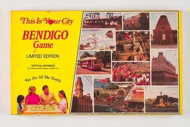 City of Greater Bendigo - Civic Collection
Leisure object - Board Game, E Systems Publications, This is Your City - Bendigo Game, 1985
This limited edition board game was produced in conjunction with local businesses and attractions and sponsored by the Bendigo Development Committee. Supported by the five local municipalities (pre amalgamation) and both State and Local governments, the role of the Committee was to promote Bendigo's economic development. Boxed board game. Yellow box lid featuring photographs of popular sights around Bendigo on right side and a family playing the game on the left on lid. Inside box includes game board, playing cards, dice and game rules. 0345a; Fold out game board. Commercially printed with a full colour stylised map of Bendigo and Eaglehawk. 0345b Set of 96 Destination Cards single side printing on coloured card 0345c Set of 32 Surprise Cards 0345d Paper money 0345e Player tokens 0345f Set of dice 0345g Letter to Players re the board game and local businesses on 'Bendigo Premier Town' letterhead. 0345h Three printed pages of discount vouchers for local businesses. 0345i Game Rulescity of bendigo premier town 1982-85, city of bendigo commerce -
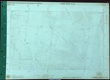 Greensborough Historical Society
Map, Melbourne and Metropolitan Board of Works. Survey Division, MMBW, Yarra 2500 / 15.26. Yarrambat, Hacketts Road, 1978_07
Melbourne and Metropolitan Board of Works. Yarra 2500 [base map] 15.26. Yarrambat, Hacketts Road. Municipality of Diamond Valley 257. Prominent streets include: Black Gully Road, Hacketts Road and Collins Lane. Features include Scrubby Creek.MMBW Map in 1:2500 [scale] series. Cream parchment with green tape reinforcing on edges and punched holes on left edge.mmbw, melbourne and metropolitan board of works, shire of diamond valley, yarrambat - maps