Showing 526 items
matching drainage
-
 Melbourne Tram Museum
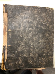
Document, Melbourne & Metropolitan Tramways Board (MMTB), Melbourne cable tram history, late 1930's
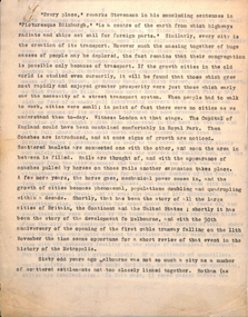
Manuscript - 29 quarto sheets carbon copy - article for publication possibly about the history of the Melbourne cable tram system. Notes cover - the background of history of city transport, the suburban councils, the formation of the MTOC, the MTT - list the various council representatives, development of the cable system, Mr. George Duncan, Dunedin, construction works, maintenance, finances, funding, contractors, construction timing, list of lines and opening dates, winding houses, the various lines, construction issues with drainage, cable lengths, horse trams. The conversion of cable trams, annual returns for 1886 to 1935. Page 22 has a heading "Why a Prophecy was Unfulfilled" - which looks at the finances of the MTT and the folding into the Tramway Board and then the MMTB, including community obligations, the MMTB Act, conversion operations, the Chairman's tour of 1923, St Kilda Road conversion, and finally conversion of Elizabeth St and Victoria St. Article dated mid to late 1930's.trams, tramways, cable trams, melbourne, public transport, history, mto co, mtt, dunedin tramways, finances, contracts, cables, construction, track construction, conversion, mmtb, chairman, community services -
 Bendigo Military Museum
Photograph - AUTOMAP 2 Production - Army Survey Regiment, Fortuna, Bendigo, c1986
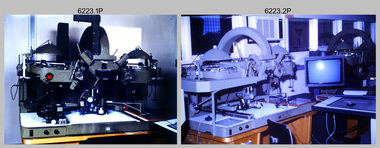
This collection of 23 photos of map production on the AUTOMAP 2 computer-based system in Air Survey and Cartographic Squadrons, was most likely taken in 1986. The AUTOMAP 2 system was an upgrade to the AUTOMAP 1 system, comprising Intergraph graphic edit workstation terminals networked to VAX 750/785 main frame computers. Unlike AUTOMAP 1, operators could display digital topographic features on monitors for editing. Successful adaptation of this system meant RASvy was at the forefront of digital mapping/cartographic systems in Australia and overseas. The system comprised Input (Wild B8 Aviograph feature extraction) Raster Scanning (digitising from compilation sheets, Graphic Edit (cartographic completion) and Plot Verification Sub Systems. The system was operational from 1984 to its ‘Newheart’ upgrade in 1993. Throughout its life, the system was progressively refined with productivity gains, achieved from award winning technical development in-house by talented and innovative Army Survey Regiment personnel.This is a set of 23 photograph of AUTOMAP 2 production at the Army Survey Regiment at Fortuna, Bendigo, c1986. The photographs were on 35mm colour slides and were scanned at 96 dpi. They are part of the Army Survey Regiment’s Collection. .1) - Photo, colour, c1986, AUTOMAP 2 Production - Army Survey Regiment, Fortuna, Bendigo. c1986. .2) - Photo, colour, c1986, AUTOMAP 2 Wild B8 Aviograph stereoplotter. .3) - Photo, colour, c1986, AUTOMAP 2 Wild B8 Aviograph stereoplotter feature extraction, unidentified technician. .4) - Photo, colour, c1986, Wild B8 Aviograph stereoplotter feature extraction, LCPL Raelene (Munting) Brodie. .5) - Photo, colour, c1986, AUTOMAP 2 computer tape maintenance, SPR Steve Linane. .6) - Photo, colour, c1986, AUTOMAP 2 Graphic Edit Workstation, SPR Steve Linane. .7) to .8) - Photo, colour, c1986, AUTOMAP 2 Graphic Edit Workstation, unidentified technician. .9 to .10) - Photo, colour, c1986, AUTOMAP 2 Graphic Edit Workstation. .11) - Photo, colour, c1986, AUTOMAP 2 Graphic Edit Workstation feature coding and command menu. .12) - Photo, colour, c1986, AUTOMAP 2 high resolution computer monitor. .13) to .16) - Photo, colour, c1986, AUTOMAP 2 production output comparison to AUTOMAP 1. .17) to .18) - Photo, colour, c1986, AUTOMAP 2 computer system components. .19) - Photo, colour, c1986, AUTOMAP 2 Intergraph 7596 verification plotter. .20) - Photo, colour, c1986, AUTOMAP 2 Benson verification plotter, SPR Steve Coulson. .21) - Photo, colour, c1986, AUTOMAP 2 drainage, contour, roads and cultural digital data verification plot. .22) - Photo, colour, c1986, AUTOMAP 2 drainage, contour, roads and cultural digital data on computer monitor. .23) - Photo, colour, c1986, AUTOMAP 2 3D digital terrain model on computer monitor. .1P to .23P - Some of the equipment is annotated on the frame of the 35mm slides.royal australian survey corps, rasvy, army survey regiment, army svy regt, fortuna, asr, automap 2 -
 Bendigo Military Museum
photograph - Cartographic Squadron Production – Army Survey Regiment, Fortuna, c1980
This collection of 12 photos was most likely taken in 1980. The photos were most likely taken in Cartographic Squadron’s Ante Room, the Attic and small offices on the top floor of Fortuna Villa. The computer based Editwriter typesetting system was introduced in 1975 as a replacement to the aging Fotosetter machine. It was operated by a specialised technician, who generated a large variety of map type styles and sizes quickly and reliably, as well as text panels. CPL Richards performed this task for several years and in photo .1P and .2P is reading off a type order next to the computer monitor. Output on Copy proof adhesive backed stripping type film replaced messy wax and spray adhesives in 1978. The Editwriter capability supported all RASvy units and contractor type setting requirements. Scribing was the cartographic process of drafting features such as drainage, relief, vegetation, roads and culture on specially coated map reproduction material. The cartographic technician scribed out the map feature such as a contour to a specified line width on the map sheet, using a tool affixed with a sapphire tipped cutter. The quality control edit (Proving) stage of map production was the first opportunity to inspect a proof of the map independently and systematically. Proving tasks were carried out by technicians conversant of the map product specification and task requirement, however, was not involved in its production. Corrections were identified, marked up and sent to back to the correcting section or contractors. Terrain Embossing was a manual map production technique to produce hill shading on medium to small scale graphics and air charts. SPR John Martin is seen in photos .8P to.10P using a fine embossing metal stylus to push down on the drainage impression on a thin malleable opaque plastic material (AK Poligraphy). Ridge lines were then pushed down using the contour impression as a guide, on the opposing side of the AK Poligraphy to create a 3D plastic model terrain effect. The map impression was sprayed with white paint and photographed to create a contone tone hill shade. SPR Gina (Coore) Neilson is seen in photo .11P washing a contone positive of a land mass in a solution. The contone components were registered to the map sheet, as shown in photo .12P and masked using an air brush and a halftone negative was then created. The terrain embossing method of producing hill shading was more efficient to produce than previous specialised artistic methods such pencil/eraser and air brush. Furthermore, a more consistent enhancement of terrain on charts was achieved between technicians.This is a set of 12 photographs of Cartographic Squadron performing four map production tasks at the Army Survey Regiment, Fortuna, Bendigo c1980. The first ten photographs were on 35mm negative film and were scanned at 96 dpi. Photos .11P and .12P were on photographic paper and scanned at 300 dpi. They are part of the Army Survey Regiment’s Collection. .1) - Photo, black & white, c1980, Editwriter typesetter, CPL Paul Richards. .2) - Photo, black & white, c1980, Editwriter typesetter, CPL Paul Richards. .3) - Photo, black & white, c1980, Scribing contours on a RAAF Chart, SPR Megan (McBurney) Reynolds. .4) - Photo, black & white, c1980, Scribing contours on a RAAF Chart, SPR Megan (McBurney) Reynolds. .5) - Photo, black & white, c1980, Scribing contours on a RAAF Chart, SPR Rod Skidmore. .6) - Photo, black & white, c1980, Scribing contours on a RAAF Chart, SPR Rod Skidmore. .7) - Photo, black & white, c1980, Formal quality control edit (Proving), CPL Ian Belmont. .8) - Photo, black & white, c1980, Hill Shade Terrain Embossing, SPR John Martin. .9) - Photo, black & white, c1980, Hill Shade Terrain Embossing, SPR John Martin. .10) - Photo, black & white, c1980, Hill Shade Terrain Embossing, SPR John Martin. .11) - Photo, black & white, c1980, Hill Shade Terrain Embossing, SPR Gina (Coore) Neilson. .12) - Photo, black & white, c1980, Hill Shade Terrain Embossing, unidentified..1P to .10P No personnel are identified. .11P and .12P annotated ‘Terrain Embossing’royal australian survey corps, rasvy, army survey regiment, army svy regt, fortuna, asr, carto -
 Melbourne Tram Museum
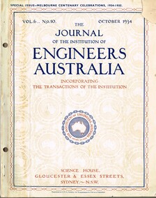
Magazine, Institute of Engineers Australia (IEAust), Journal of the Institution of Engineers Australia" - Vol 6, No. 10, Oct. 1934, "Metropolitan and Provincial Tramways", Oct. 1934
Journal or magazine - stapled pages approx. 100 printed on semi gloss paper, with glue outside cover, titled Journal of the Institution of Engineers Australia" - Vol 6, No. 10, Oct. 1934 - Special issue - Melbourne Centenary Celebrations 1934 - 1935. Contains transactions of radio frequency, institution and related activities, and 100 years of Engineering in Victoria. These include maps of Victoria and Melbourne, Engineering Education (Kernot), Metropolitan Roads and Bridges by J. Noble Anderson City Engineer of Richmond, Country Roads and Bridges, Railway Development (VR), Metropolitan and Provincial Tramways (Strickland and Russell), Port of Melbourne, Outer ports, air transport, water supply, sewerage and drainage, gas industry, electricity supply, communications (telephone and telegraph), industrial development and mining. Has ads for British Insulated cables, Thompsons Engineer, Goodyear, GEC - British General Electric, Associated General electric, Vickers and many other companies. Photocopy of article from the Bob Lilburn collection.trams, tramways, centenary, victoria, tramways, railways, secv, mmtb, cable trams -
 Bendigo Historical Society Inc.
Document - NORMAN OLIVER COLLECTION: MAYOR'S NOTES 1964
The Norman Oliver collection. Norman Oliver was three times Mayor of Bendigo - 1950-51, 1964-65, 1970-71. 1. Two covering pages, with handwriting in blue pen. Mayor's Notes 1964, and Contents of File - Mayor's Notes 1964, Bendigo, Local Government, Town Planning, Water - Coliban Area, Business - marketing, etc., Speech for Graduation of Nurses. 2. Four typed pages of undated Mayor's Notes which make reference to the first week as Mayor, and learning of his appointment on 29 August. Topics include : a council business meeting dealing with the use of the Garden Gully sports facilities, the Housing Commission garden competition, Royal Commission on supply and consumption of liquor, neighbourhood disputes regarding drainage issues and owner responsibility, Rotary Club slide presentation on Bendigo past and present, tenders to Council for supply of a range of materials, Art Gallery Committee meeting (noting the need for careful selection policy re. donations and borrowings).bendigo, council, speech notes, norman joseph oliver , councillor norman oliver. mayor of bendigo. bendigo art gallery. rotary clubs - bendigo. royal commission on supply and consumption of liquor. -
 Federation University Historical Collection
Book, The Melbourne Technical College Hydraulic Engineering
Two volumes of course notes for the course of Hydraulic Engineering at the Melbourne Technical Collegehydraulic engineering, melbourne technical college, rmit, rex hollioake, leakage, aquaducts, dams, spillways, ground water, pumping, curvss, pipes, reservoirs, tanks, weir, channel, water supply, sewerage, sewers, sewerage treatment, drainage -
 City of Moorabbin Historical Society (Operating the Box Cottage Museum)
Newsletter, City of Moorabbin Historical Society Feb 2010 pdf, February 2010
The City of Moorabbin Historical Society was formed c 1960 by a group of Moorabbin residents who were concerned that the history of the area should be preserved. A good response to a call for items related to the historical area of Moorabbin Shire brought donations of a wide variety of artefacts which are now preserved by the current members of CMHS at Box Cottage Museum . Helen Stanley, Secretary of CMHS, began producing a Newsletter for members in April 2007 to provide current information and well researched items of historical interestHelen Stanley has produced a bi-monthly Newsletter, 2007 - 2013, for the members of the City of Moorabbin Historical Society that contains well researched interesting historical items, notification of upcoming events, current advice from Royal Australian Historical Society , Museums Australia Victoria and activities of Local Historical Societies. The Newsletter is an important record of the activities of the CMHS5 x A4 paper printed on 1 side Issue 15 of the bi-monthly, City of Moorabbin Historical Society Newsletter produced by Society member and Secretary, Mrs Helen Stanley in February 2010. Notices for the meeting February 28th , subscriptions due, and this is 50th Anniversary of CMHS. Water flooded Joyce Park, the grounds of the Cottage and a little seeped into Grace Lewis Room in December 2009 when a water main at the neighbouring Bowling Club burst, but little damage occurred and the Glen Eira Council will install drainage pipes between Box Cottage and the Bowling Club. In January, 2 brush tailed possums had taken up residence in the Barn and after failed attempts by Helen and Dennis to move them, Glen Eira Council relocated them. A description of the establishment of Cobb & Co Coaches by Freeman Cobb in 1853, for cartage between Melbourne and the Ports but they soon began transporting people and mail to the gold fields around Victoria. 3 photocopied photographs of Cobb & Co Coaches and 1 photo of the 2 Possums CITY of MOORABBIN HISTORICAL SOCIETY / February 2010 NEWSLETTER city of moorabbin historical society, stanley helen, maynard dennis, melbourne, moorabbin, cheltenham, ormond, bentleigh, market gardeners, pioneers, early settlers, moorabbin shire, box cottage museum, lewis grace, cobb freeman, cobb and co coaches, ballarat, goldfields, gold miners, bendigo, castlemaine, governor latrobe, victoria, sydney road, sutherland alexander, chinese gold miners -
 Eltham District Historical Society Inc
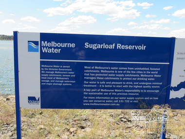
Photograph, Sugarloaf Reservoir, Christmas Hills, 16 January 2015
Sugarloaf Reservoir is situated on former farmland. This large water storage was completed in 1982 and serves Melbourne's northern suburbs. Within the visitor areas are two picnic grounds and other recreational facilities. Below its massive rock embankment is located the Winnecke Treatment Plan designed to purify its water before being piped into Melbourne. The dam partly inundated the old firing ranges of the former Christmas Hills Rifle Club. Source: Christmas Hills Now and then: Yarra Glen & District Historical Society, 2004. Born DigitalMelbourne Water Sugarload reservoir Melboure Water is owned by the Victorian Government. We manage Melbourne's water supply catchments, remove and treat most of Melbourne's sewrage, and manage waterways and major drainage systems. Most of Melbourne's water comes from uninhabited, forested catchments. Melbourne is one of the few cities in the world that has protecyed water supply catchments. Melbourne Water manages these catchments to protect our drinking water. Our water is safe and pleasant to drink, and undergoes minimal treatment - it is better to start witht he highest quality source. A key part of Melbourne Water's responsibility is to encourage the sustainable use of this precious resource. For more inforamtio on our water supply and on how you can conserve water, call 131 722 or visit www.melbournewater.com.auchristmas hills, sugarloaf reservoir, sign, melbourne water -
Bendigo Historical Society Inc.
Document - DRAINAGE PROBLEMS - NEW CHUM DRAINAGE PROPOSALS
Six pages of handwritten notes regarding the New Chum Drainage Proposals. Extracts from the Bendigo Advertiser mentioning the rising of the water in the New Chum Mines. An Advertiser report 27/12/1910 mentions that deep mining will have to be abandoned owing to the absence of some proper scheme to cope with the water. An arrangement had been made by which the companies affected along the line should contribute to a scheme. Suggestions made that the water be lifted by electric pumps. Baling with tanks had been tried for 6 months and then abandoned. Directors Report Victoria Reef Quartz Jan 1911 mentions unwatering had been carried on with assistance of Government. On the 20th Dec, one rope gave out. Decided that replacing it and doing the necessary work could not be met in the present financial conditions. It was also considered that the costof trying to reach the bottom reefcut in the New Chum Railway could not be continued by baling as its cost proved too expensive, while it could probably be done economically & effectively by electric pump which is now subject to negotiations with the Mining Dept.' At the end of the report is a Balance Sheet.document, gold, drainage problems, drainage problems, new chum drainage proposals, bendigo advertiser 11/1/1911 page 7, victoria quartz, victoria consols, bendigo advertiser 5/7/1910 page 3, mr h v whitelaw, mines dept, insp ross, lansell's 180, 222, new chum consolidated, lazarus, bendigo advertiser 6/7/1910 page 7, 9/7/1910 page 9, drainage troubles, bendigo advertiser 8/7/ page 8, new chum railway, south belle vue, eureka ext'd, bgo adv 25/7 1910, 27/12/1910 page 2, rae's machine, bendigo advertiser 2/1/1911, mr mcbride, mines dept, mr stanfield, mines act, bendigo advertiser 16/1/1911 page 3, victoria reef quartz half yearly meeting 1911, directors report and balance sheet, geo paynting -
Glen Eira Historical Society
Plan - Ristori
Real Estate leaflet for the subdivision sale of the Ristori Estate & Residence on 31/05/1919 by Yeo, Crosthwaite & Co. A map of the 24 subdivisions available plus a locality plan are included along with details of separate sale on 04/06/1919 of the weatherboard buildings, rooms, stables & glass house.house names, 'ristori', land sales, sewerage, glen eira road, brick houses, land subdivision, orrong road, glasshouses, yeo crosthwaite & co melbourne, ripponlea, stables, ristori estate, auctions, drainage, liscard street, st. georges road, balaclava road, glen huntly road, glenhuntly road, elsternwick station, hotham street, weatherboard buildings, elsternwick -
Bendigo Historical Society Inc.
Document - DRAINAGE PROBLEMS - VICTORIA QUARTZ INFLUX OF WATER
Handwritten copy of a report in the Bendigo Advertiser 12/7/1910 Page 2. New Chum Mines. Progress of Bailing Operations. The bailing operations at the New Chum mines have not yet had the desired effect of lowering the water. On the contrary the water continues to rise in the Victoria Quartz which is the mine most directly affected. It is expected that the necessary preparations at the Lazarus will be completed today when it is hoped that bailing will be commenced at that mine. The success of the bailing scheme will largely depend on the efforts of the Lazarus to cope with the water and the progress made during the next few days will be awaited with interest. It is generally believed that the great volume of water is coming north from the southern group of mines. The companies south of the New Chum Consolidated are not bailing, and the pumping service at the New Chum Railway which is installed down to the 550 ft. level has not been operated since that company abandoned work a few months ago. A perusal of the statistics of the New Chum Drainage Association shows that the pumps at the New Chum Railway were lifting on anaverage close on 1,000,000 galls of water per month in the winter. That great volume of water is now pouring from storage dams at 550 feet to the deep levels, and in the natural order of things will have to be lifted by the tanking system in vogue at the mines N.'document, gold, drainage problems, new chum drainage association, victoria quartz influx of water, bendigo advertiser 12/7/1910 page 2, victoria quartz, lazarus, new chum consolidated, new chum railway, new chum drainage association -
 Old Colonists' Association of Ballarat Inc.
Photograph - Photograph - Colour, Ballarat Old Colonists' Association Homes, Charles Anderson Grove, Ballarat
HISTORY OF THE BALLARAT OLD COLONISTS' ASSOCIATION HOMES AT CHARLES ANDERSON GROVE, LAKE GARDENS One of the original objectives of the Association was “to provide the shelter of a house for those Pioneers of the Goldfields whom the reverses of fortune have deprived of the means of procuring the comforts of life in their declining years.” While the first home at Charles Anderson Grove was built in 1925 the Association had previously provided relief for needy pioneers from the time it was formed in 1883. Relief included monthly monetary payments, loads of firewood, medical assistance and distribution of Christmas boxes of groceries to deserving pensioners and in some cases payment of burial costs. Records indicate that in September 1922 three of the pensioners being assisted by the Association were accepted as residents in the newly erected Hassell Homes in Gillies Street (now demolished-opposite the High School). The first site for an Asylum for Indigent Members of the Old Colonists' Association was temporarily reserved from sale in October 1891. The site was approximately 28 acres in area in Mt Clear nearly opposite Midvale Shopping Centre in Main Road. The site was heavily timbered and when cleared over 260 tons of wood was sold to the Woah Hawp Gold Mining Company. A set of gates were erected but no homes built, although a plan for this reserve was drawn which showed twenty buildings ranging from one to four unit per building. The reserve was revoked in November 1909. The second site temporarily reserved in November 1909 as an Asylum was in Alfredton and consisted of some 7 acres and was adjacent to land reserved for an Abattoirs for the Ballarat Council. The reserve was revoked in February 1912 as it was deemed more appropriate to be added to the Abattoir site. Council suggested four (4) other sites in exchange for this land and they were inspected by the President, Vice President and Secretary on 22 December 1912. The first site inspected was land on the west side of Creswick Road opposite the brick kilns (now occupied by the showgrounds and oval). The land was described as being good quality, well fenced, no trees, good drainage and ample acreage but some distance from trams. The second site was Perry Park which was described as being good land, well fenced, having frontage to Gillies Street, good drainage and about 26 acres (but subsequently reduced to 10 acres). It was closely planted with Pinus Insignias and Wattle and had easy access from the Botanic Gardens tram. The third site was the North West portion of Victoria Park (corner of Sturt and Gillies Street) and was described as good land, well fenced and drained and well located. The fourth site was the South West corner of Victoria Park and known as Pound Paddock (corner of Winter Street and Gillies Street). It was considered to be low lying and too close to the Abattoir, and was also a considerable distance from trams. While the third site was recommended as the most suitable for the erection of homes it was considered unwise from the point of view as citizens to reduce the acreage of the park and therefore it was recommended that the Perry Park site be asked for as the most acceptable to the Association for the building of homes. The site was eventually temporarily reserved for an Asylum for Indigent Members of the Association in April 1914 with the gates from Mt Clear having been removed to the site a year earlier and eventually erected in 1917 for £12.10.0. In the same year the first 290 pine trees were advertised for removal in July and sold for £16. A sign indicating that the site was reserved for the erection of cottages was erected in September 1917. Stripping of the wattle bark (for tanning) and the cutting of the wood occurred in November 1918 with the land then being leased until it was required for the construction of the first homes in 1924. While the site was the third to be reserved it was the only one which was used for its intended purpose. It was named as Charles Anderson Grove in honour of Charles Anderson who joined the Association in 1918 and was President of the Association from 1942 to 1944. A number of cottages in the Ballarat Old Colonists' Association Retirement Village of Gillies Street, Ballarat.charles anderson grove, old colonists' club, ballarat, old colonists' association, old colonists' homes, retirement village -
Bendigo Historical Society Inc.
Document - MINING REPORTS - MINING RECORD FEB., 1862
Photocopy of pages 2, 3, 4, 6 to 10 of The Mining Record, Feb., 1862. Items mentioned are:- Epsom and Huntly Leads, Pottery Flat, & c, Parliamentary Intelligence, Deep Sinking On Quartz Reefs, The Comet Company (Formerly Cooper's Little Redan), Hustler's Reef Quartz Mining & Drainage Company, Sailors' Gully Quartz Mining Company, Star Reef, Sailor's Gully, Bendigo, Star Reef Quartz Mining Company's Claim, Wilson & Co's Claim, Murdoch and Co's Claim, Hollick and Co.'s Claim, Cook and Co.'s Claim, Coote and Co.'s Claim, Sailor's gully quartz Mining Company's Claim, Garden Gully Reef, Knobel & Co.'s Claim, Ladams and Co.'s Claim, Southern Cross Company, The Rainbow Company, Barry and Co.'s Claim, Union Company's Claim, Winterbottom and Co.s Claim, Jury and Co.'s Claim, Piles and Co.'s Claim, Steers and Co.'s Claim, Watson and Co.'s Claim, Coles and Co.'s Claim, James and Co.'s Claim, Morgan, Kirchner and Co.'s Claim, Boyd and Co.'s Claim, Shanks and Co.'s Claim, Day and Co.'s Claim, Brown and Co.'s Claim, St. Mungo Quartz Mining Company and the Nelson Reef Quartz Mining Company.document, gold, mining reports, mining reports, mining record feb 1862, bell's life, wellington hotel, botanical gardens, mitchell gardens, bird-in-hand, independent co, ballarat co, perserverance co, north star co, all england co, macleod co, mather and co, gold washing co, bendigo valley co, robey and co, hobbs and co, taylor's, lewis and co, henwood and co, bullock and co, davey and co, webb and lathlean, the welshman's, bon accord, john thomas's, caledonian co, webster, hrdy bros, mcewen and co, the big engine co, epsom huntly and ironstone hill co, 'the thames' steamer, whitely and co, cambridge co, victoria co, dower m'intosh and co, thomas and davies, aurora co, brett's, thomas bros, mitchell brothers, ballarat co, north star co, all england co, mr b g davies, mr ramsay, dr evans, tarrangower times, mr humffray, clunes co, mr courtin, mr lawrence, port phillip and colonial gold mining co, mr bland, r brough smith, john s mcnair, john mathieson, mr r o smith, joseph millen, thomas kaye, john basset, william cook, james cousley, john hill, robert hollinger, thomas houston, george loudon, william manning, john matthews, john mcewen, thomas milligan, john moorhead, robert moorhead, david murdoch, andrew murdoch, joseph nevin, edward o'malley, wm newton paul, james reid, samuel robinson, jesse selwood, james shand, william woods, catherine united claimholders, star reef co, sailor's gully co, churchill davidson, wm wilson, john jervis, james patterson, john carmont, george m'naughten, alexander wiseman, james houston, m'lennan, clark, thomas hollick, james alfred bowles, john lampert, francis palmetser, nichols, little pumping engine co, m'niely, morrison, waight, john coote, robert hamilton, william wilson, john jervis, southern cross co, ladam's claim, knobel, bird, philip ladams, james anderson, cordon, ashley, godwin, burkamp, john lomasney, james bryant, matthew langridge, benjamin exley, j r finlayson, wormold, mccartney, schrade, schumacher, george barry, james patten, peter speares, thomas caley, shadbolt, john lomasney, peat, kenely, mcgenely, egan, exwell, james winterbottom, john winterbottom, william jury, jonathan laidman, john pile, simon howard, peter morris, bignall, charles robison, ferguson, thomas steers, adolphe witts, albert berchdolt, richard urand, thomas watson, klemm, boyd, abbot, peterson, taylor, henry day, walter wallan, brown, grennan, day, young, mr beckwith, joseph thomson, nelson reef quartz mining co -
 Ringwood and District Historical Society
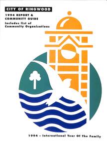
Book, City of Ringwood, City of Ringwood 1994 Report & Community Guide, 1994
The City of Ringwood and the City of Croydon merged in December 1994 and became the City of Maroondah.Community information book issued by City of Ringwood for 1994 - covering the facilities and activities of the Ringwood Council and other local organisations and associations. Includes Ringwood Public Golf Course discount vouchers and two Ringwood Aquatic Centre bonus entry vouchers.CONTENTS: (page no.) Contents A Message from the Mayor - Cr. Margaret Cheevers 3 Your Council 4 Local State and Federal MPs 5 Council Meetings and Elections 6 History of Ringwood 7 City Manager's Report 8 Organisational structure 9 Human Services 10-19 Environmental Health 20-21 Ringwood Library 22 Parks and Gardens 23 Ringwood's Parks and Reserves 24 Building 25 Engineering Planning Services 26-28 Waste Management 29 Town Planning 30 Traffic and Local Laws 31-33 Roads, Drainage and Major Works 38-39 Halls and Facilities 40-41 Aquatic Centre 42 Convention Centre/Karralika Theatre 43 Golf Course 44 Free Swim & Golf Discount Vouchers 45 Community Organisations 46-64 Finance 65-66 Administration 67 Community Liaison 68 Information Systems 69 Personnel 70-71 Risk Management 71 Rates and Valuations 72 rinx -
 Ringwood and District Historical Society
Letter, Letter written by H.C.Howship to Ringwood Mail Ringwood 1963
To the Editor of the Ringwood Mail Dear Sir, would you please publish in your widely read paper the following letter for the information of the residents of the City of Ringwood- Re the passing of my brother Mr. J.P. Howship, who was an ANZAC one of the pioneer family of Howship of Ringwood which name is connected with the early history of Ringwood or more particularly Ringwood East as the late J.P. Howship and myself purchased the Nursery of Mr. John Hill around the year 1912 and after a couple of years my late brother Bert was taken into partnership and we bought the adjoining nursery of Mr. Will Hill and traded under name Howship Bros. Rosedale Nursery and the name of one street in the old property Howship Avenue is named after the old firm as well as Rosedale Crescent. The move for the establishment of the Ringwood East station started with myself and in a meeting up with a Mr .T. Birkitt who I felt was the man I needed as he was a sub Estate Agent .A meeting was called and held in our packing shed at the end of Federal Road which at that time ended at Mr. Charlie Burdens property and abbuted (sic) on our property. This meeting was attended by about sixty residents and the late Mr. C. Wedge was elected as the first President of the Ringwood East Railway League and Progress Assoc. with Mr. T. Birkitt as Secretary and myself as assist. Secretary. This League raised the sum of about 1,600 from residents and land owners for the erection of the Ringwood East Railway Station & after the station was erected and paid for the League part was canceled and the Progress Assoc. carried on. The present Ringwood East Cricket Club was formed at meeting and the Prog .......and my three brothers Bert, Mervyn and played cricket in the Ringwood district for many years and most of us were members of the Ringwood at first and then the Ringwood East Football clubs and followed the teams for years a few names of the old players came to mind in E. Thomas , C. Weil, T. Homewood, the Pratt family and others. I might mention for the benefit of the City of Ringwood residents my eldest brother Laurie late of New Street and now living at Blairgowrie was with what was then known as Coopers Mills and designed and helped to build some of the first buildings in that property now known as Ringwood Timber & Trading Co .Also that myself and others namely the Reidy Brothers, Mr. Taylor, & L .Cleary & voluntary labour formed the tennis courts at East Ringwood with the help of our young Ladies of the time, those courts I'm pleased to say are well established and two more are added and provide good activities for the young people of the district. Also with the aid of C .Thomas, Norm Blood and others we formed the Methodist courts. From the Ringwood East Progress Association came the move to have a Health Centre for Ringwood. This was established by a good deal of enthusiastic work by some mothers after spending nearly fifty years in Ringwood watching it grow from town surrounded by orchards to a City and I must congratulate the Civic Fathers and their staff in the growth of Ringwood and the fine roads, Parks, Elderly Citizens Club and have all done a good job but why oh why have you neglected mines Road Ringwood east. Why has this road not been made the drainage there is something to be seen to be believed in such a city .The only solution is making and curbing this road & I would ask those responsible why the curbing was put down Dublin Road where there are no residents this curbing could well have solved the problem in Mines Road if used there. I recently spent a weekend with my Daughter, Mrs. Munro at the corner of Maroondah highway and Mines Road and was disgusted at the condition of Mines Road and drainage and had to air my views and suggest a trip to Mines Road by the Civic Fathers led by the Health Inspector I am yours sincerely H.C. Howship Sheila Street, Rye. (copied here verbatim)3 pages of hand written letter detailing the early history of the East Ringwood Railway and Progress Association, football, cricket and tennis clubs.. Written as a draft in 1963. -
 Eltham District Historical Society Inc
Film - Video (VHS), IMP Productions, The Shire of Etham - The Evergreen Shire (Series 69, Item 4), c.1985
Shire of Eltham Archives: Series 69, Item 4 This video was produced for the Shire of Eltham by IMP Productions and provides a description of the shire, 277 square km on a north/northeast axis, some 25 km northeast of the centre of Melbourne with a population of around 40,000. Scenes include Yarra River, rural settings and urban settings, housing estates, Shillinglaw Cottage, Pigeon Bank at Kangaroo Ground, the Eltham Railway Trestle Bridge with reference to the fight by locals in the 1970s to save it from replacement, Montsalvat, mudbrick making and its use as a building material, the use of mudbrick in the Eltham Community Centre blending harmoniously with the environment. Emphasises people living in the area due to the qualities of life provided. Also the Living and Learning Centre, St Andrews Markets and other local markets, the Eltham Leisure Centre, cricket and horse riding at Eltham Lower Park, the Infant Welfare Centre (part of the Eltham War Memorial), how residents are mindful of protecting their historical heritage, the CBA bank and Allwood House at Hurstbridge, Tracey Naughton about the Eltham "As we are" Community Banner project and the “River of Life banner”, the Parks and Gardens office in the former Police Residence building (now the Local History Centre), Alistair Knox Park, road planning and types of roads, tree canopy, Peck's Dam, green carparks, road drainage, Gordon Ford's garden and natural landscapes, and Were Street shops in Montmorency. Planning for shopping facilities and carparks with a population of 40,000 growing to 55,000, Arthur Street Mall and carpark, local village feel in the shopping centre. Councillors and Council staff featured include Mary Grant, Bob Manuell, Rodney Roschellor, John Cohen, Alan Baker. Also scenes of Commercial Place, Diamond Valley Railway, Eltham Galley, Riverclay and canoeing on the Yarra intermingled with images of the shire from the Shire of Eltham Pioneers Photograph collection.VHS Video cassette Converted to MP4 file format 00:11:56; 79MBshire of eltham, video recording, shire of eltham archives, alistair knox park, allwood house, arthur street, arthur street mall, bob manuell, canoeing, carparks, cba bank, commercial place, council staff, councillors, cr. mary grant, cricket, diamond valley railway, eltham community banner project, eltham community centre, eltham galley, eltham leisure centre, eltham living and learning centre, eltham lower park, eltham railway trestle bridge, eltham war memorial, gordon ford garden, horse riding, housing estates, hurstbridge, infant welfare centre, john cohen, kangaroo ground, local history centre, montmorency, montsalvat, mudbrick, parks and gardens, peck's dam, pigeon bank, police residence, river of life banner, riverclay, road drainage, road planning, rodney roschellor, shillinglaw cottage, shire of eltham pioneers photograph collection, st andrews market, tracey naughton, tree canopy, were street, yarra river, alan baker -
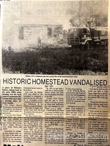 Melton City Libraries
Newspaper, Historic Homestead Vandalised, 1990
Edna Barrie describes the Darlingsford property. C.E. Barrrie Land developers bought the property from my husband’s brother. It was one big farm and they were a big family. When the father died he left it to be cut up for the family. The youngest son had to reach age 21 before the property could be divided and portioned out to the mother and children, but it was deferred until Jim returned from the war. Eventually it was cut up into two parts, we were married by then and so was Edgar. Part of the land included the block on the other side of Ferris road, which became the quarry, Edgar’s section was on the Toolern Creek end, he was the last one married and lived in the old bluestone house until 1974. The developers bought this section but they could not get permits due to the state of the old bridge due to the cost. Barries had built the bridge across the creek [1926]. It took the big loads of hay and the family kept it maintained. Once the Barries had gone it did not get any upkeep. The developers found the cost of replacing the bridge and developing site with sewerage and drainage power before they sell. The rural land itself is not worth much as the developer has to complete the subdivision before any blocks can be sold. The developer from Sydney had a man living in the house, who let it go the rack and ruin. He managed to buy from the developer 25 acres with the bluestone house. Bernard Coburn had it for a while but is was well out of our hands by then. There were various people who have bought into and tried to develop and have given up. There was a project sometime ago to save the buildings from ruin but nothing has happened as yet, they are six or seven years to late. The buildings continue to deteriorate and were badly damaged vandals and fire. The Shire bought all the rest of it from the developer, where the tip is now, that was also part of Edgars land. Article about a fire at Darlingsford Estate featured in the Telegraphlocal architecture, local identities, emergency services -
 University of Melbourne, Burnley Campus Archives
Album - Colour slides, Burnley - Miscellaneous Views, 1954-1969
Contributor: T.H. KneenBox of slides, mostly labelled. 1. "School Building (May 1960) No. 1950." 2. "Students 5-2-58 John Richards Helen Page Instructor J.B. Nowell No. 1881." 3. "Orchard-Burnley (1960) No. 1953." 4. "Flower Bed & Lawns No. 1774." 5. "Plant Science Block Jul 69." 6. "Citrus myrtifolia being lifted (1960) No. 1945." 7, 8, "Mar 67." 9. "Dec 66." 10. "Long Border Aug '54 No. 1758." 11. "Border Display & Pond No. 1792." 12. "Rose Pruning Jul 67." 13. "Grampians-MCK Falls 10/65." 14. "Archway- Burnley Gar Yellow Banksia Rose No. 1779." 15. "P.R.L. No. 1684." 16. "Principal's Residence (Spring) Amygdalus pollardii No. 1716." 17. Views of Drive No. 1676." 18. "Field Day '57 Demonstration Burnley No. 1917." 19. "Shrubs & Annuals No. 1772." 20. "Burnley Gardens Flower Beds & Lawns Aut 1957 No. 1742." 21. "Vegetable GardenStudents 5.2.58 John Deverson Dorothy Issell Instructor I.G. McCure." 22. "School Lawn Golden Willow No.1754." 23. "Rose Pruning Demo No.1969 Jul 89." 24. "Field Day '57 Budding Burnley No. 1911." 25. "Field Day 57 Drainage No.1918 Burnley." 26. Rose Pruning Demo T. Komebum? Jul 69." 27. "Rose Pruning Demo Jul 69." 28. "Orchard." 29. "Wilson's Promontory N. P. Tidal River."school building, students, john richards, helen page, j.b. nowell, burnley, flower beds, lawns, administration building, orchard, plants, long border, rose pruning, grampians, principals residence, vegetable gardens, students working outside, lawnmower, john deveson, dorothy issell, golden willow, field day, wilsons promontory -
 Ballarat Tramway Museum
Document - Lecture Notes, Metropolitan Transit Authority (MTA), "Tramway Permanent Way", 1987
Seventy two page photocopied document within card covers and outer plastic covers with an additional introduction page between front clear plastic cover and card cover bound with a white comb binder. Book titled "Tramway Permanent Way" presenting a series of lectures by MMTB Per Way officers in 1928 at Hawthorn Depot. Contents in order: 1. Handwritten note from Chris Jacobson on Metropolitan Transit Authority of Victoria memo paper forwarding a copy to Warren Doubleday of the BTPS in Feb. 1988, with date received stamp at depot of 19/2/1988. 2. Photocopy of a memo on Metropolitan Transit letterhead from K. C. Painter dated 20/7/1987 to the Civil Engineering Design drafting staff forwarding a copy of the 1928 lectures to the then current staff. 3. Photocopy of a circular from J.P. Strickland, Chief Engineer to track inspectors, sub overseers, overseers and senior gangers advising that a series of weekly lectures on track work would be held at Hawthorn Depot commencing 23/1/1928. 4. Lecture notes: 1. Interpretation of Drawings 2. Alignment etc 3. Alignment continued and special work 4. The drainage system 5. Concrete 6. Rails and Fastenings 7. Welding 8. Timber 9. Paving and paving materials 10. Track cross sections. Second copy added 27/11/2010 - ex PPW holdings. Both items transferred to Box 99.\ Scanned copy added 15-12-2016.trams, tramways, trackwork, mmtb, lectures, tramway per way, training -
Bendigo Historical Society Inc.
Document - MCCOLL, RANKIN AND STANISTREET COLLECTION: BELLEVUE TRIBUTE COMPANY LEDGER
a. Hard cover ledger, 242 pages, dark buff colour,paler buff spine and corners. Bellevue Tribute Company ledger 1871 - 1873. Written on spine, on red label 'Ledger". Affixed inside front cover account from Charles C. White, auctioneer, dated September 21, 1872 listing sale of 900 shares, signd by Chas White, agent for the legal manager. Receipt affixed on next page, blue paper, outlining receipts from sale of shares forfeited from the Bellevue Tribute Co. Alphabetical index with details of individual ledger entries. Ledger entries include: dividends,wages, crushing, carting, stores and materials, firewood, mining materials, foundry work, management, contractors, treating pyrities, auditors fees, bullion, drainage, and share calls accounts. Individual share holders' accounts listed: W. Brooks W.J. Scott, W.V. Gilbert, H. Boyd, J.B.Loudan, A.B. Shaw, J.. Taylor W. Bentley, J. Cole, Antonio Damiana, Thomas Francis, Peter Strickland, W.J. Dalzell, Arthur O'Neill L. Robertson, J. Wallen, A. Raynor, I.H. Simpson, william Brookes, William Barclay, H Crow, C. Keen, J.B. Loridan, M. Leeds, Arthur O'Neill, M. Sullivan, William Scott, I Britten, J. Cohn, J. Cox, C. Franklyn, E. Fry, I.L. Morley, A. Lennox, J. Penistan W. Smith. b. Brief typed account of some entries in ledger. ITEMS IN THIS BOX HAVE NOT BEEN SCANNEDbusiness, mining, bellevue tribute -
Glen Eira Historical Society
Article - Watts, William Cowley
This file contains three items about Willian Cowley Watts, brother of Thomas Henry Watts:. Photocopy of two articles from newspapers. One relates to a portrait of William Cowley Watts, who was the shire president of Caulfield, for the memorial gallery of Mayors. The other states the history of Glen Huntly, the first architect designed house in Caulfield, the home of Thomas Watts. Research notes on the Watts family of Caulfield. A photocopy of a portrait of William Cowley Watts, shire president of Caulfield.watts william cowley, watts thomas henry, shire president, councillors, caulfield, monuments, memorials, portrait, gallery of mayors, city offices, architects, architecture, national trust, victorian institute of architects, city surveyor of melbourne, drainage system, watts charles george, caulfield grammar school, fellow of the federal institute of accountants, city treasurer of melbourne, watts geoffrey, glen huntly, glenhuntly, glenhuntly traders association, caulfield city council, huntly street, grange road, glenhuntly road, watts john, watts mary, thos. h. watts and sons, shire of caulfield, drainage, irrigation sewerage, sanitation, land surveys, royal society, mansion, retail trade, merchants, station place -
Bendigo Historical Society Inc.
Document - DRAINAGE PROBLEMS - INRUSH OF WATER AT THE VICTORIA QUARTZ
Two handwritten copies of a Bendigo Advertiser report 16/6/1910 Page 7. This is a longer version of 3600.14. It was thought that the rush of water was from a dam bursting in one of the other mines, but as the water showed no signs of slowing that theory was discarded. The temperature of the incoming water was much higher than the Victoria Quartz was accustomed to bail, and this circumstance is significent in view of the increased temperature of the water at the deep levels in the New Chum Railway. Some months ago, the water commenced to flow from the New Chum Railway workings into the New Shenandoah, which is the next mine north. The water rose so rapidly that a disaster was narrowly averted. The mines along the line were connected at different levels and with the cessation of bailing at the deep levels in the southern mines, it was only to be expected that the water would find its way north to the Victoria Quartz. The water raised from the operating mines under the direction of the New Chum Drainage Association, a yeart or two ago used to exceed six million gallons per month. At that time there were eight companies bailing water, and even then some of the plants, especially those at the deep mines, were severely taxed in coping with the water, and performing ordinary work. Since some mines had discontinued bailing, the water has been filling up extensive workings, and as was predicted in the ''Advertiser'' some time ago, the Victoria Quartz Company could not expect to succeed with its deep sinking project without making some special provision for raising the water, which ultimately would become a source of trouble. The Victoria Quartz Company was allotted a special grant of 10,000 pound to assist in sinking the shaft 1000 ft from the 4254 ft level. Under the conditions of the grant, the Company had to contribute half the cost of the sinking, and the raising of the water has also been an exensive item. For the present, all attention will be concentrated in lowering the water, and should the appliances prove unequal to the task the deep sinking scheme can only be accomplished by resorting to some comprehensive system of combating the water'.document, gold, drainage problems, drainage problems, inrush of water at the victoria quartz, bendigo advertiser 16/6/1910 page 7, mine reports 13/6/1910, victoria quartz, lansell's 180, mr stevens, mr w abraham, new chum & victoria mine, new chum railway, new shenandoah, new chum drainage association -
 Old Colonists' Association of Ballarat Inc.
Photograph - Image, The History of Charles Anderson and Charles Anderson Grove, Ballarat
Information relating to Charles Anderson and Charles Anderson Grove, Lake Gardens, Ballarat. The Old Colonists' Association Ballarat Inc. is a not for profit charitable organisation providing accommodation for elderly people. It manages a 27 Home retirement village at Charles Anderson Grove, Ballarat. Accommodation is offered at significantly below market rates. It has been providing low cost accommodation to the elderly since the 1920s. The Association Council overseas the running of this facility on a voluntary basis. HISTORY OF THE BALLARAT OLD COLONISTS' ASSOCIATION HOMES AT CHARLES ANDERSON GROVE, LAKE GARDENS One of the original objectives of the Association was “to provide the shelter of a house for those Pioneers of the Goldfields whom the reverses of fortune have deprived of the means of procuring the comforts of life in their declining years.” While the first home at Charles Anderson Grove was built in 1925 the Association had previously provided relief for needy pioneers from the time it was formed in 1883. Relief included monthly monetary payments, loads of firewood, medical assistance and distribution of Christmas boxes of groceries to deserving pensioners and in some cases payment of burial costs. Records indicate that in September 1922 three of the pensioners being assisted by the Association were accepted as residents in the newly erected Hassell Homes in Gillies Street (now demolished-opposite the High School). The first site for an Asylum for Indigent Members of the Old Colonists' Association was temporarily reserved from sale in October 1891. The site was approximately 28 acres in area in Mt Clear nearly opposite Midvale Shopping Centre in Main Road. The site was heavily timbered and when cleared over 260 tons of wood was sold to the Woah Hawp Gold Mining Company. A set of gates were erected but no homes built, although a plan for this reserve was drawn which showed twenty buildings ranging from one to four unit per building. The reserve was revoked in November 1909. The second site temporarily reserved in November 1909 as an Asylum was in Alfredton and consisted of some 7 acres and was adjacent to land reserved for an Abattoirs for the Ballarat Council. The reserve was revoked in February 1912 as it was deemed more appropriate to be added to the Abattoir site. Council suggested four (4) other sites in exchange for this land and they were inspected by the President, Vice President and Secretary on 22 December 1912. The first site inspected was land on the west side of Creswick Road opposite the brick kilns (now occupied by the showgrounds and oval). The land was described as being good quality, well fenced, no trees, good drainage and ample acreage but some distance from trams. The second site was Perry Park which was described as being good land, well fenced, having frontage to Gillies Street, good drainage and about 26 acres (but subsequently reduced to 10 acres). It was closely planted with Pinus Insignias and Wattle and had easy access from the Botanic Gardens tram. The third site was the North West portion of Victoria Park (corner of Sturt and Gillies Street) and was described as good land, well fenced and drained and well located. The fourth site was the South West corner of Victoria Park and known as Pound Paddock (corner of Winter Street and Gillies Street). It was considered to be low lying and too close to the Abattoir, and was also a considerable distance from trams. While the third site was recommended as the most suitable for the erection of homes it was considered unwise from the point of view as citizens to reduce the acreage of the park and therefore it was recommended that the Perry Park site be asked for as the most acceptable to the Association for the building of homes. The site was eventually temporarily reserved for an Asylum for Indigent Members of the Association in April 1914 with the gates from Mt Clear having been removed to the site a year earlier and eventually erected in 1917 for £12.10.0. In the same year the first 290 pine trees were advertised for removal in July and sold for £16. A sign indicating that the site was reserved for the erection of cottages was erected in September 1917. Stripping of the wattle bark (for tanning) and the cutting of the wood occurred in November 1918 with the land then being leased until it was required for the construction of the first homes in 1924. While the site was the third to be reserved it was the only one which was used for its intended purpose. It was named as Charles Anderson Grove in honour of Charles Anderson who joined the Association in 1918 and was President of the Association from 1942 to 1944. CHARLES HENRY GRATTAN ANDERSON C.H.G. Anderson (Electoral Returning Officer) was elected to membership of the Old Colonists' Association, Ballarat, in October 1918. He was elected to the Association Committee in 1926, and appointed Treasurer of the Association on the resignation of F. Ellis until the end of the financial year in 1933. In 1936 Charles Anderson indicated he would not be available for the President's Chair and that he would retire from the Committee owing to pressure of work. C.H.G. Anderson was welcomed as a new member of the Association in 1938, and served as President of the Old Colonists' Association from 1942-1944. Midway through 1949 Charles Anderson was appointed Members Secretary and Manager of the Ballarat Old Colonists' Club at £5.0.0 per week and 10/- for entertainment, to commence work prior to 01 August 1949. He was to do 30 hours per week and be present on Friday and generally on Saturday nights. In 1957 a minute of sympathy was extended to Club Manager Charles Anderson on the loss of his son. In 1958 a bonus of £20.0.0 was paid to Charles Anderson in recognition of his service in assisting the Secretary/Manager taking over under difficult conditions. In March 1964 the Shire of Ballarat would not permit a private road to be named Anderson Grove as Anderson Street already existed in Ballarat but Charles Anderson Grove was deemed acceptable. A recommendation of the Committee was put to the AGM in 1967 that Charles Anderson be made a Life Member. In 1969 an Association meeting observed a minutes silence in memory of Chas Anderson. Charles Anderson was also a Committee member of Ballarat Mechanics' Institute from February 1940 to February 1970. He was President in 1948. Black and white photographic portrait of Charles Anderson.charles anderson, charles anderson grove, ballarat old colonists' club, old colonists' association, ballarat, ballarat mechanics' institute, hassell homes, woah hawp gold mining company, firewood, retirement village -
 The WAMA Project : The National Centre for Environmental Art
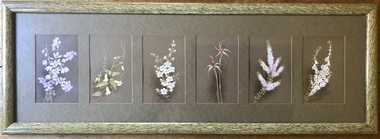
Painting, Marianne Wehl (1867 - 1926), Untitled (Tetratheca ciliata, Marianthus bignoniaaceus, Leptospermum myrsinoides, Thryptomene calcina, Epacris impressa), c1887 to 1924
The artist: Marianne Louise Charlotte Amalie Wehl (19 Sept. 1867, Mt Gambier; 26 Oct. 1926, Melbourne), a flower painter who was active in South Australia and Victoria, and not to be confused with Marie Magdalene Wehl. Connection with Baron von Mueller: Von Mueller’s younger sister, Clara married Doctor Eduard Wehl and they lived in South Australia. They had 14 children, 6 of whom collected and painted botanical studies – some now in the National Herbarium, Melbourne. A cousin of Doctor Wehl – Carl Wehl – married Sophia Caroline (née Gorte) and one of their daughters was Marianne Wehl. It is recorded that von Mueller visited the Wehls and D’Altons in Halls Gap (Henrietta D'Alton was also a painter of wildflowers), so it is hard to believe that there is no influence at least. Von Mueller had over 1,400 collectors/artists working for him and 225 of them were women and children. Their work is housed in the National Herbarium, Melbourne. The donor believes that Marianne contributed to this work. There is no record of that, however, as only 169 of the artists have been identified, it may be a possibility. Marianne was one of six children of Carl Jakob Wilhelm Wehl (1830–1899) and Sophia Caroline Wehl (née Gorte) (1843–1920). She never married. https://data.environment.sa.gov.au/Content/Publications/JABG34P001_Dowe.pdf The plants: All of the plants painted by Marianne Wehl's in this donation were identified by Botanist Neil Marriott & Wendy Marriott, in July 2022. Neil Marriott said that the quality and beauty of these botanical studies made it easy for them to identify all the plants. He suggested they may be some of the first paintings of Grampians wildflowers. This makes the paintings highly important scientifically and botanically. Visitors to WAMA will be able to compare them with today’s plants in the Endemic Garden. Neil marvelled that Marianne found the specimens, as some of them are endemic and found only in the highest parts of the Grampians (Mt Rosea, Mt William and Major Mitchell Plateau) and are listed as rare and endangered. Some of these same rare plants have now been propagated by the WAMA team and in winter 2022 were planted in WAMA's Endemic Garden. Left to right: (Neil's comments) Tetratheca ciliata - Black-eyed Susan. Common and widespread. Marianthus bignoniaceus –Orange Bell-Climber. Confined to drainage lines and winter-wet areas, generally well shaded. A most beautiful light climber with the Grampians being its only location in Victoria, but amazingly, it is also found in small numbers in the wetter parts of the Mt Lofty Ranges and on Kangaroo Island in South Australia. Although not strictly endemic, it has been propagated for planting in our endemic garden due to its rarity in Victoria. Leptospermum myrsinoides - Heath Tea-tree. Common and widespread. Spider Orchid Caladenia species- need my orchid books for accurate identification! Thryptomene calycina - Grampians Thryptomene. Grampians endemic but common. Epacris impressa - Common Heath - white flower form. Common and widespread NB In some records she is called Marianna (as the donor calls her) and in others Marianne. Wildflower art, Wildlife artGift of Barbara Crick in memory of Marjorie and Lachlan McLennanSix individual, small paintings of Grampians wildflowers, matted together and framed in a smooth gloss olive green simulating wood or bamboo.All are signed with the initials “M.W.” underlined, to the left or right of the stem of the plant. On the reverse side - Shield-shape stamp centre top: “J.A. Reynolds. Decorator & Picture Framer, 28 Sturt St., Ballarat”. Hand-written right of that in black felt pen at an angle, “McLennan, 106 Bennett Rd. (2)”.wildflowers, flowers, marianne wehl, marianna wehl, wama, painting, gouache, wildlife art museum australia, wild art museum australia, flower painter, works on paper, halls gap, botany, baron von mueller, ferdinand von mueller, carl wehl -
 Melbourne Tram Museum
Document - Folder with papers, Folder of memos and directions, c1940
Folder of Memos and directions (htd3207i1> htd3207i8) - Air raid precautions, covering painting, respirators, sheds, tools, kits, shelters, stacks , blackouts, trenches, emergency, air raid shelters (htd3207i9> htd3207i16) - Accidents, covering accidents and derailments, (htd3207i17) - Bridges – inspection of Victoria St bridge (htd3207i18) - Cable tracks, covering tarring, patching, top dressing of cable tracks (htd3207i19> htd3207i21) - Cartage, covering hired trucks, cartage of wood blocks, spoil, sleepers (htd3207i22> htd3207i23) - Contracts, blank page (no image) - Councils, covering track opening, storm water drain, bad roads (htd3207i24) - Costs, covering maintenance costs, construction costs, wet weather (htd3207i25> htd3207i26) - Depots, covering inspections, storage, paving, telephones, mail (htd3207i27> htd3207i30) - Derailments, covering controls, reports (htd3207i31) - Drainage (htd3207i32) - Eastern Lines, covering loading platforms, crossovers, work orders (htd3207i33> htd3207i34) - Eastern Lines Reconstruction (htd3207i35> htd3207i37) - Eastern Line Maintenance (htd3207i38> htd3207i40) - Estimates (htd3207i41) - Employment (htd3207i42) - Footscray Lines (htd3207i43) - Instructions (htd3207i44) - Journals, covering Engineering Journal and magazines (htd3207i45) - Materials – General, covering frames & covers, unloading stores, packing plates, petrol allowance, ashes at Preston workshops, electrodes, sleepers (htd3207i46> htd3207i50) - Maintenance – General, covering loading platforms, inspections, work orders, paving (htd3207i51> htd3207i57) - Northern Lines, covering greasing of curves, crossovers, loading platforms (htd3207i58> htd3207i61) - Northern Lines – Reconstruction, covering crossings, welding machines (htd3207i62> htd3207i64) - Northern Lines – Maintenance, covering repairs, crossings, lifting programme, fencing, curves, track inspection, repairs (htd3207i65> htd3207i70) - New Lines (htd3207i71> htd3207i80) - Plant – General (htd3207i81> htd3207i94) - Plant – Concrete Mixers (htd3207i95) - Plant – Motor Vehicles (htd3207i96> htd3207i100) - Plant – Rollers (htd3207i101> htd3207i103) - Plant – Grinders (htd3207i104) - Plant – Grinders & Scrubbers (htd3207i105> htd3207i110) - Plant – Compressors and Tie Tampers (htd3207i111) - Plant – Cleaner Cars (htd3207i112> htd3207i114) - Plant – Loaders (htd3207i115) - Plant – Tools (htd3207i116> htd3207i117) - Plant – Miscellaneous (htd3207i118) - Per Way – General (htd3207i119> htd3207i121) - Public Utilities (htd3207i122> htd3207i123) - Reconstruction – General (htd3207i124> htd3207i126) - Railways (htd3207i127> htd3207i129) See \dbtext\hawthorn\photo_collections\3207_Folder for scanned images.trams, tramways, instructions -
 Wodonga & District Historical Society Inc
Album - Hume Reservoir Australia Album - Detail plan and explanation, Department of Public Works, N.S.W, 1927
This set of photos is from a leather bound album bearing the inscription "HUME RESERVOIR AUSTRALIA" plus 'The Rt. Hon. L. C. M. S. Amery, P. C., M .P.' all inscribed in gold. It was presented to The Rt. Hon. L. C. M. S. Amery, P. C., M. P, Secretary of State for Dominion Affairs on the occasion of his visit to the Hume Reservoir on 2nd November 1927. This album is of local and national significance as it documents the planning and development of the Hume Reservoir up to 1927. It was the largest water reservoir in the British Empire. The album records the pioneering engineering work that went into its construction.2. Detail Plan and Section. Starting from the New South Wales and there will be an earthen embankment 430 feet 6 inches long which is retained by the North Wing Wall. Then come the sluice section 284 feet 3 inches long, the spillway 720 feet long and the South Wing Wall, making a total length of 1,042 feet 6 inches of concrete wall. Beyond the South Wing Wall is earth embankment again to a length of 3,827 feet. The Full Supply Level is R.L.626.00 and allowance has been made for a surcharge of 9 feet. A road will run along the top of the dam at R.L.642.00. The sluice section contains seven offlets, the three nearest the north wing wall being 13 feet in diameter for hydro-electric purposes and the other four 9 feet in diameter for regulation purposes only. There are to be stony sluice gates on the upstream ends of the outlets and needle valves on the downstream ends. The shock of the discharged water will be taken by a stilling pool. Trash racks will protect the intake ends of the outlets. Next comes the spillway section, which is curved on the downstream face, and carried up to within 15 feet of the full supply level. Above that will be a series of piers between which will be the flood gates and on top of which the roadway will be carried. The gates will be 20 feet wide and 15 feet high and will be 29 in number. They will slide down the face of the wall when opened for the escape of the water. The investigation of the control of this cascade of water was made by means of a model and as a result the form of “bucket” or energy dissipater shown on the section of the spillway was decided upon. The earth embankment in Victoria is being constructed by the State Rivers and Water Supply Commission of Victoria who are the Constructing Authority for that State under the River Murray Waters Agreement. The core of the embankment is of concrete 6 feet wide at the base tapering to 2 feet at the top end and is reinforced with steel rods from the level of the decomposed rock upwards. On the downstream side, at about natural surface level, is a tunnel for drainage and inspection purposes. Above the tunnel is a vertical layer of large stones to drain any seepage to the tunnel. Against the core wall is packed selected material of as impervious a character as can be got locally and beyond that the bank is carefully built up in horizontal layers by means of horses and wheel scoops. The upstream slope is 3-to-1 hardening to 2½-to-1 at the top and the downstream slope is 2½-to-1 hardening to 2.07-to-1 at the top. The thrust of the upstream toe is taken by a mass of granite blocks, and this face is protected by concrete laid in situ. The width of the bank at base is 650 feet and at top 32 feet.hume reservoir australia, river murray waters scheme, hume weir diagrams, hume plan details -
Glen Eira Historical Society
Document - GARDENVALE
This file contains two items about Gardenvale, which was previously all part of Caulfield: 1/Photocopied eight page document by M. Stewart, 1961, entitled ‘The Gardenvale Story’. It describes Gardenvale Railway and surrounding roads and land. Lempriere’s Paddock, rail tracks on the main roads for the use of market gardeners’ wagons. Sale of land for O’Neill College Estate and construction of a subway through the railway embankment to Gardenvale Shopping centre, including efforts by local people and the council for work to be completed and costs. Footnote is circa 1977. 2/Map of Glen Eira printed from Council website 20/06/2014 showing Glen Eira’s share of Gardenvale.gardenvale, bent thomas, brighton, caulfield, elsternwick, railway stations, lempriere family, ‘bentville’, lempriere’s paddock, market gardens, nepean highway, nepean road, north road, kooyong road, polo, sheridan family, bluestone houses, bethlehem hospital, land subdivision, begonia street, gardenia road, gardenia street, magnolia street, lantana street, martin street, shops, ‘ben burb’, house names, padua hospital, brighton, o’neill miss, o’neill college, o’neill richard, o’neill estate, elster avenue, o’neill college estate, railway crescent, denver crescent, brentani avenue, college street, rosstown railway, brighton cemetery, ross mr, hawthorn road, ormond, gardenvale progress association, elster creek, parliamentary representatives, landscapes, gardenvale road, railway lines, subways, traders association, drainage, floods -
Federation University Historical Collection
Document, Dianne Campbell, Ballarat Lawyers 1853-1895 Research Folders, c2000-2021
Folders of research notes on Ballarat Lawyers, including newspaper clippings, website information, etc. .1) Ballarat Lawyers - A (Australian Law Firm histories, Jamaican in Australia, History of the Court System, University of Melbourne Law Students c1870s, Melanie Senior, Cinque Oakley Senior Lawyers, 19th Century Castlemaine Police Courts, New Victorian County Court, Scots and the Law in Scotland, Solicitor online encyclopedia, Alfred Akehurst, Artur Akehurst, J.T. Ansdell, Butler Cole Aspinall, Alfred James Bailey, Henry Stephen Bailey, Matthew Baird, Hugh Sutherland Barrett, William Field Barrett, Redmond Barry, George Elliott Barton, George Frederick Bartrop, John Bell, Thomas Bellas, George Booker) .2) Ballarat Lawyers B (Hugh Sunderland Barrett, Peter Beckford, William Beckford, John T.F. Bowker, William Box, George Boyd, William Boykett, B. Browne, Richard Archer Burton, Alfred Butler) .3) Ballarat Lawyers C-E (Thomas B.S. Carwithen, J.B. Cathcart, John Alfred Chalk, David Clarke, John Collins, Matthew Combe, Thomas Spemcer Cope, Richard. Crouch, Charles Curwan-Walker, Frank H. Cole, John Rowland Davies, Charles J. Dawson, Christopher John Dease, J.E. Dixon, Robert Willian Dobson, Roy Dobson, Edward Doward, Charles R. Doward, Edgar R. Doward,) .4) Ballarat Lawyers F-G (Charles B. Finlayson, Peter T. Finn, John Findlay, John Fitzgerald, John Olsen Foss, Alexander Fraser, J.A. Doane, Andrew Garran, George Garrard, David Gaunson, William Gaunt, MAry Gaunt, F.T. Gell) .5) Ballarat Lawyers H-J: (Frederick Ham, Jeremy Harper, John H. Harris, solicitors, Amelia Harris, J. Henry Harris, Peter Blake, Henry Plomer, Arthur Plomer, Ballarat Chamber of Commerce, Freemasons, White Flat Drainage and Mining Company, Henry R. Nicholls, Francis Ham, Richard T. Harvey, Edward Heady, Peter Heinz, T.t. Hollway. Thomas tuke hollway, William Higgins, James V.M. Hitchins, frederick Hitchins, James Hitchins, Edward Hockley, Robert W. Holmes, Catherine Kain, JOhn Ireland, Richard D. Ireland, Peter Jacobs) .6) T.C. Williams, John Kidahl, Arthur W. King, Pendrell family, M.A. Lazarus, Edward Lewis, W.H. McCormick, Soho Foundry, Henry S, Ochiltree, James V. McCormick, McDonnell, Townsend MacDermott, Morgan McDOnnell, Percy McDonnell, Cyprian McDonnell, John McFarland, Samuel W, McGowan, Bill McGregor, David Madden, Charles Holthouse, J. Madden, Samuel Mann, Samuel F. Mann, Tobias Furneaux, Samuel Mann, Agar Wynne, thomas Mann, Henry MacDermott, Archibald Midnie, Arthur Nevett, Arthur H. Nevett, Alfred Mitchell, William Mitchell, H.W. Morrow, William Mitchell, Norman P. Must, George F. Oakley.) .7) Ballarat Lawyer Q-R (Henry S. Ochiltree, W.B. Ochiltree, Edward G. Ochiltree, J.J.P. O'Dee, Bernard O'Dowd, John Ogier, Cornish Lawyers in Central Victoria Q-R, John Bateman Paynter, J.B. Pearson, Mondle Emmanuel Phillips, Robert King Piers, Robert King Piers, Pinkerton, Frank Pinkerton, Martha Pinkerton, Charles Purcell, R.H. Ramsay, Henry Randall, James Randall, Thomas Randall, John Warrington Rogers, John M. S. Rodd, George Rutler) .8) Lawyers in Central Victoria S-W (Charles Salter, H. Holmes, George Staveley, Charles Salter, George T. Boyd, Edward Sandford, Henry G. Shaw, Thomas W. Snape, Thomas S. Standish, Charles Snape, Frederick C. Standish, Edith Snape, James Snape, Thomas Snape, Philip Snape, George Staveley, John G. Stoker, William Stone, Henry Sturt, Matthew W. Taylor, Bread and Cheese Club, R.D. Thompson, Roger D. Thompson, R.H. Ramsay, R.G. Turner, F.H. Tuthill, W.M.K. Vale, William Vale, May Vale, William L. Vardy, Gordon Vardy, William S. Vardy, Charles Von Ende) .9) Lawyers in Central Victoria W-Z (Henry Walker, Andrew Wallace, John Wellesley, Brereton Watson, C.G.M. Watson, James Watson, George Armytage, Thomas Watson, Patricius Welsh, John Westmore, Theodore Whipham, Arthur Whipham, Thomas H. Whipham, Frances Whipham, Thomas Bellas, James L. Willoughby, John Noble Williams, James Wisewould, Horace Wright, H.M. Wright, William Wright, Henry J. Wrixon, Agar Wynne, Samuel Young) . ballarat lawyers, ballarat, dianne campbell goldfields lawyers collection -
 Flagstaff Hill Maritime Museum and Village
Document - Plans, Lighthouse Keeper's Quarters Warrnambool, 1858-1909
The set of seven 1858 plans shows proposed plans for the original Lighthouse Complex that was built on Middle Island in 1858-1859. The whole complex was then transferred to Flagstaff Hill in 1871. The plan, dated 1909, is for proposed additions and repairs to the Quarters at Flagstaff Hill. The plan 'Alterations and Additions' shows alternate plans for changes to the quarters at the Flagstaff Hill location. This plan has no date. The Complex comprised the Lighthouse, the Lighthouse Keepers’ Quarters, the Store (now called the Chart Room) and a Privy, which was not included in these plans. The Keeper’s bluestone Quarters was a cottage divided into two compartments, one for each keeper and his family. The bluestone Store was divided into three; a store, a workshop an oil store (or office). The Privy comprised of a small building also divided into two separate, back-to-back toilets, one for each Keeper and his family. The Flagstaff Hill Keeper's Quarters have had extensions and additions at various times, and these have also been removed at various other times. THE PLANS - *Dec. 1858 (12/58) ‘Lighthouse Keepers Quarters No.2 Warrnambool’ (2375.01)* Public Works Office Melbourne – Front and Back elevations, sections, and floor plan. The drawing shows timber walls. [The floor plan is the closest plan to the current building, however, the walls are timber in this plan.] *Nov. 1858 – No.3 ‘Lighthouse Keepers Quarters Warrnambool’ (2375.02)* Office of Public Works, Melbourne – Back and End elevations and section through. The drawing shows stone walls. One side; Senior Keeper’s bedroom, living room and kitchen with storeroom. Another side; is the Assistant’s bedroom, living room and storeroom. *Nov. 1858 - No.4 ‘Lighthouse Stores Warrnambool’ (2375.03)* Office of Public Works – Front, Side and end elevations, centre section. The drawing shows stone walls. *Nov. 1858 – No.4, ‘Lighthouse Stores No. 2 Warrnambool’ (2375.04)* Office of Public Works – Front, side and end elevations, centre section. The drawing shows timber walls. *Nov. 1858 – ‘Details Lighthouse Keepers Quarters No. 2 Warrnambool’ (2375.05)* Public Works Office Melbourne. The plan shows the foundations, joists and eaves. The drawing shows timber walls. (Nov. 1858 – ‘No.4 ‘Lighthouse No. 2 – Warrnambool’ (2375.06)* Public Works Melbourne (Part of the paper is missing). This plan shows an octagonal tower, internal stairs, a balcony landing, and a weather vane on top. *November 1858 – No. 1, ‘Lighthouse – Warrnambool’ (2375.07)* Office of Public Works Melbourne. This plan shows a round tower, including the stairs, windows on the tower and the weather vane on the top. *4/3/9 [1909] – ‘Additions and Repairs, Lighthouse Quarters, Warrnambool, General Plan’ (2375.8)* Department of Public Works Melbourne’s official stamp is signed by Croft. It shows the floor plans of the Store, Upper Lighthouse and the Quarters. The Store building has three sections; a Store, Work-Shop and Office, with an internal wall between them and separate entries. The Quarters are divided into two dwellings. The Senior Keeper’s side on the left has fireplaces in two of the three bedrooms and there is a pantry and wash house. The Assistant’s side has no fireplaces in the bedrooms and there’s no pantry or washhouse. These plans include proposed changes to the buildings. The Senior Keeper’s Quarters would have a partition on bedroom 2, a bath with plumbing and drainage, a wall moved and a built-in side porch. The Store would also have a built-in porch. The undated plan 'Additions and Alterations' (2375.9) shows alternative arrangements for water tanks, plumbing and such. WARRNAMBOOL'S LADY BAY LIGHTHOUSES- In the 1800s ships sailing from England to Australia began to use Bass Strait as a faster route to Melbourne. Small navigation errors led to many tragic shipwrecks. From 1848 lighthouses were operating along Victoria’s southern coast as a guide for sailors. Coastal towns such as Warrnambool grew and the exchange of trade and passengers were of great benefit. However, the uncertain weather changes, relatively shallow waters and treacherous, hidden rocky reefs were not suitable for a Harbour and in the 1840s and 1850s there were many shipwrecks in the area, with some even stranded in its Lady Bay harbour. A jetty was built in 1850 and a flagstaff to guide seafarers was placed up high on what became known now as Flagstaff Hill. In November 1857 the Victorian Government recommended that Warrnambool Harbour had beacons and two lighthouses to guide vessels into and out of the Harbour safely. The white light of the Middle Island lighthouse was to be used for the first time on September 1, 1859. The red light of the Beach Lighthouse, a wooden obelisk structure, was first operated on March 25, 1860, but in 1868 this light was ‘discontinued’ due to it being too low. Melbourne’s Department of Public Works decided to relocate the Middle Island Lighthouse Complex - Lighthouse, Keeper’s Quarters, Privy, Store Room and even water tanks - to Flagstaff Hill. The lower obelisk was shortened, and a protruding gallery, railing, and external ladder were added, as well as the light from the Beach Lighthouse. A green guiding light was erected on the end of the jetty. The transfer of the Complex began in March 1871. Each shaped stone of the lighthouse was carefully numbered, removed then reassembled on Flagstaff Hill. In 1872 the well was sunk behind the Lighthouse Keeper’s Cottage. The Keepers and families had left Middle Island in April and moved to Flagstaff Hill in October 1871. Vessels entering Lady Bay align the Upper and Lower Lighthouse towers during the day and the lights at night. The Upper Lighthouse is a round tower, the Lower Light is square. The Lighthouses were categorised as harbour lights rather than coastal lights, so they remain under the control of the Victorian Government’s Ports and Harbours section. The lights were originally powered by oil, then acetylene gas, later by electricity, and then converted to solar power in 1988. In 1993 the solar panel was replaced by a battery charger. A decision was made in 1936 to replace the lighthouses’ lights with unattended lights that no longer required Keepers and Assistants. At least 29 Keepers had attended to the lighthouse from its opening in 1859 to when the last official Lightkeepers left In April 1916. The Warrnambool Harbour Board rented out the Quarters from 1916 to 1936. The Board closed down but the rentals continued with other unknown landlords. In the 1970s the Flagstaff Hill Planning Board was set up under the chairmanship of John Lindsay. The Board was to make recommendations to the Warrnambool City Council regarding the use of the buildings and the rest of the Crown Land on the site. The Flagstaff Hill Maritime Village opened in 1975 and began renovating the Cottage in stages, during which time evidence of a 1920s fire was found in the eastern section of the cottage. Additions of a porch on the west and a washroom on the east were made in the 1980s. The western part of the building is now a Shipwreck Museum and the east has returned to a late 19th-century Lighthouse Keeper’s cottage and includes the screen made by Assistant Lighthouse Keeper Thomas Hope during one of his two periods of service there. THE LIGHTHOUSE KEEPERS Lighthouse Keepers were responsible for keeping their Lighthouse’s lights shining at night. They kept a lookout for passing vessels and changes in weather. They were expected to clean, polish and maintain the equipment and buildings. They kept regular and detailed records of who was on watch, and the time the light was lit, trimmed and extinguished. They kept a journal about other events that occurred. They keep regular, accurate Meteorological Logs. It was expected that they were competent in Morse code signalling. They would be called to help in times of disasters and shipwrecks, and to give official statements about these events. Many Lighthouse Keepers also volunteered as members of the lifeboat crew. The Lady Bay lighthouses were officially classified as small, so the Keepers had the official titles of Senior Assistant Lighthouse Keeper and Assistant Lighthouse Keeper. They were employed by the Public Service and paid rent to live in the Lighthouse Quarters. They were compulsorily retired at the age of 60, with most receiving a superannuation payment. Despite their time-consuming duties, there was time to follow hobbies and crafts such as growing vegetables, playing musical instruments, making models of buildings including lighthouses, and crafting furniture pieces. An example of a keeper’s skills is the carved fire screen made by /assistant Keeper Thomas Hope in the early 20th century and displayed in the Lighthouse Keeper’s cottage at Flagstaff Hill. The last occupants of the Middle Island Complex were Senior Keeper Robert Deverell, his Assistant Keeper, Andrew Farncombe, and their families. They all became the first occupants at the Lady Bay Lighthouse Keepers’ Quarters on Merri Street. The Warrnambool Lighthouse Complex plans are the origin of what is now the Lady Bay Lighthouse Complex. They are a record of the people, process and departments involved in bringing the complex into fruition. The plans are significant to the Complex, which is now listed on the Victorian Heritage Register, H1520, for being of historical, scientific (technological) and architectural significance to the State of Victoria. The Complex is significant as an example of early colonial development. The plan are significant for their connection with the important navigational function of the Lighthouses, a function still being performed to this day. The plans are also significant as an example of a product from the Public Works Department in Victoria in the mid-to-late 19th century. The structures built to these plans still stand strong. Plans for the Lighthouse Complex in Warrnambool, including Lighthouses, Keeper's Quarters and Stores. Seven of the plans are on thin fragile paper, one is on thicker, stronger paper. The drawings have been made in pens coloured red and black. They originate from Public Works in Melbourne. Seven were drawn in 1858, one in 1904, the other is not dated.Dec. 1858 - Lighthouse Keepers Quarters No.2 Warrnambool. Public Works Office Melbourne. Nov. 1858 - No.3 ‘Lighthouse Keepers Quarters Warrnambool. Public Works Office Melbourne. Nov. 1858 - No.4 ‘Lighthouse Stores Warrnambool. Office of Public Works. Nov. 1858 - No.4, ‘Lighthouse Stores No. 2 Warrnambool. Office of Public Works. Nov. 1858 - Details Lighthouse Keepers Quarters No. 2 Warrnambool. Public Works Office Melbourne. Nov. 1858 - No.4 ‘Lighthouse No. 2 – Warrnambool. Public Works Melbourne. Nov. 1858 - No. 1, Lighthouse - Warrnambool. Office of Public Works Melbourne. 4/3/9 [1909] - Additions and Repairs, Lighthouse Quarters, Warrnambool, General Plan. Department of Public Works Melbourne. SIGNED "Croft" "15A" on reverse [no date] - Lighthouse Quarters Warrnambool, Additions and Alterations. "9A" on reverseflagstaff hill, warrnambool, lighthouse keeper's cottage, lighthouse residence, lighthouse, plans, public works, melbourne, flagstaff hill maritime museum, maritime museum, shipwreck coast, flagstaff hill maritime village, chart room, quarters, privy, middle island, beach lighthouse, obelisk, lighthouse keeper, assistant keeper, lighthouse complex, lady bay, lady bay complex, keepers, upper lighthouse, lower lighthouse, ports and harbours, cottage, harbour board, flagstaff hill planning board, meteorological record, robert deverell, andrew farncombe, warrnambool port, warrnambool harbour, residence, alterations, repairs, department of works -
 Ballarat Heritage Services
Photograph - Photograph - Colour, Sunnyside Mill Bridge over the Yarrowee, Hill Street, Ballarat, 2016, 17/09/2016
"A joint meeting of city and town ratepayers, convened by Messrs Francis Jago and Henry Johns, interested in the formation of a cart bridge in Hill street, over the Yarrowee Creek, was held on Saturday evening, in the Societies Hall, corner of Skipton and South streets, with the view of taking united action in the matter. Mr Morris was voted to the chair, : and about 60 persons were present. The chairman stated that the object of the meeting was that united influence should be brought to bear upon the City and Town Councils, so that a cartbridge should be erected. He said that Mount Pleasant would no doubt be thickly populated in a few years, and the bridge would prove a great boon to the inhabitants of the locality. By means of a cart bridge drays, would be enabled to save on their journeys to and fro between the mount and the batteries, at least a mile and a half each time. He hoped that the councillors for the south ward would assist them in this matter. Mr Jago, as one of the conveners of the meeting, said that united action on the part of both eastern and western ratepayers was requisite, so as to exert a strong pressure upon the City and Town Councils, in order that the work should be carried but. Mr Grainger moved the first resolution as follows;—“ That the construction of a cart bridge over the Yarrowee Creek at Sunnyside, to facilitate communication between the residents of the city and town, is urgently necessary, and that in the interests of both municipalities the two councils be asked to at once jointly carry out the work. In doing so he said that the necessity of a cart-bridge for the residents of Mount Pleasant would be apparent when the number of batteries, tanneries, and also the Woollen Mill, in the district were considered. The place was of growing import ance, and ready communication should at once be established. Another reason was that an immense saving in time would be effected. It was quite a common occurrence to see one, two, or three drays stuck in the bed of the creek which had gone that way to make a short cut. Now, what with the horses floundering about and breaking their harness, it seemed a wonder to him that life had not been destroyed before now, just through the want of a cartbridge. Mr Johns seconded the resolution. Mr Robert Calvert supported the resolution, and said that it was disgraceful action on the part of the representatives of the south ward that the work had not been executed long ago. They should come together like men and demand that the work should be done, and if not done they should not pay rates until it was. (A voice—“But they’ll make us.” Laughter.) The wooden footbridge across the creek was “only a wooden fabric, not fit for a Christian to walk across, and steps should be taken to remedy this also. Mr Blight, a resident of Mount Pleasant, said that, in common with others, he had been opposed to the erection of the bridge two years ago, but his views had since been altered. Cr. Morrison, who was present, said that the fault of the cartbridge not being erected over the Yarrowee at Hill street lay not with the City Council, but with their neighbors, who had always been opposed to its erection there. In 1874 a motion was carried at a meeting of ‘the City Council" by which the sum of £5OO had been voted to carry but the work. As the bridges over the Yarrowee were joint undertakings of the city and town, they had, by the provisions of an act of Parliament, called upon the Town Council to assist them in the erection of the bridge. In consequence, a conference of the two corporate bodies had taken place, when a motion was moved by Cr Howard, the representative of the south ward, and seconded by Cr Turpie, of Ballarat East—“ That the bridge should be erected at Hill street.” The motion was rejected, principally through the eastern representatives, who wanted the bridge lower down. Since then the two councils had often met to consider, the question of bridges over the Yarrowee Creek, but nothing had been done at the meetings, as the Eastern Council wanted the bridge in one place and the City Council in another. He had himself, when first elected to the council, given notice of motion affirming the desirability of a bridge, at the place now fixed upon. The Woollen Company was growing in importance, and a direct, road to its works would greatly advance its interests. For the working, expenses of each ward £400 was annually, appropriated; and this amount would not be sufficient carry out the work. They would have to obtain a special grant of about £900, as Hill street would require a culvert to be erected therein, as now it was virtually an open drain which carried the drainage of the western plateau to the Yarrowee. He advised that strong pressure should be exerted, specially upon the Eastern Council, and then the work might be carried out. He thought that if the foot bridge was repaired, and large stones thrown into the creek, it would do until the bridge could be erected. The chairman then put the resolution, and it was unanimously carried. Mr Hamilton moved the second resolution— “That Messrs Fern, Greenwood, Peirce, and Jago be deputed by the meeting to wait upon the City and Town Councils and present the first resolution; also that petitions in its favor be signed by all ratepayers interested.” Mr Haigh seconded the resolution, which was carried. Votes of thanks to Cr Morrison for his attendance, and to the chairman for presiding, were passed, and the proceedings terminated." (Ballarat Star, 9 August 1881, page 3) "WOOLLEN MILL BRIDGE YARROWEE IMPROVEMENTS Though brief the official ceremony of opening the bridge across the Yarrowee Creek, near the Sunnyside Woollen Mills, was of an interesting character. It took place at noon yesterday in the presence of the Mayors and councillors of the City and Town. Hon. F. Hagel thorn (Minister of Agriculture).Hon Brawn. M.L.C., Lt-Col Morton (Acting City Clerk). Mr J. Gent (Town Clerk of Ballarat East), Mr A. Farrer (City Engineer), Lt. L. Finch (who is about to leave for the Front, and who assisted Messrs A. Farrer and G. Maughan in carrying out the project, Mr W. Hurdsfield (Clerk of Works) and others. An apology was received from Mr J. McClelland, contractor for the work. Mayor Hill expressed pleasure in Introducing Mr Hagelthorn, who had at great personal sacrifice and inconvenience come from Melbourne to perform the opening ceremony of that beautiful bridge, which was of great improvements that had been effected.When Mr Hagelthorn was Minister of Pubic works he visited Ballarat specially to see the condition of the creek, which at that time was in a disgusting state from a sanitary standpoint. After viewing the position, and realising the justice of the claim. Mr Hagelthorn made strong representations to the Government of which the was a member with the result that it voted £17,000 for the work. That action had been the means of turning a plague spot into a thing of beauty. They therefore owed a deep debt of gratitude to Mr Hagelthorn and the Government of which he was a member, and they were particular grateful to Mr Hagelthorn for coming to Ballarat to perform the open ceremony. Mayor Levy said he could bear testimony to the good work Mr Hagelthorn had always done for Ballarat. In him Ballarat and district always had a good friend. He thought Mr Hagelthorn would feel amply gratified at seeing the good work that had been done. It would serve as some reward for the expenditure, on behalf of the residents of Bal larat, of the amount of money made available through Mr Hagelthorn's instrumentality for the two municipalities. Otherwise the City and Town councils would not have been able to carry out so necessary and so beneficial a work. There was a great amount of work yet to be done, and when the financial market became low stringent Mr Hagelthorn would no doubt be pleased to take the necessary steps to have money provided for further works which could not be undertaken at the present time. The adjacent woollen mill was a standing monument to what was being done in Ballarat, and what ever the City and Town Councils or the Government could do to encourage such manufacturing enterprise should be done, and he was glad to be able to say that was being done as far as finances would permit. He concluded by presenting Mr Hagelthorn with a gold mounted pocket-knife with which to cut the ribbon stretched across the centre of the structure as a bar to traffic. The Hon. F. Hagelthorn, who was greeted with applause said before him was a good work well done in the interests of the public. Real prosperity could only be achieved by a movement carried out by the people to increase natural productiveness. Most of them had been made aware, on account of the war par tiularly, that the people who were best equipped, the industries that were best organised, and the Governments that were most intelligently controlled would get the most of this world's goods and some of its luxuries that Would be denied other people less efficient. Any thing the Government could do to promote industry and to increase the reward of those engaged in it, both employer and employee, would be done. Most Governments would do but little in that regard. ... " (Ballarat Courier, 13 September 1916, page 4)Bluestone and iron bridge over the Yarrowee River at Hill Street, Ballarat.sunnyside mill, sunnyside woollen mill, ballarat woollen mill, bridge, yarrowee creek, francis jago, mount pleasant, yarrowee river, robert calvert