Showing 1513 items matching "country road"
-
 Kiewa Valley Historical Society
Photographs and copies of photographs of the pack horses and early horsemen who transported supplies to outposts in the Bogong High Plains, via cattle tracks before access roads were made
In the mid to late 1930’s survey outposts were established to plot the early stages of the Kiewa Hydro Electric System for the SECV in the Bogong High Plains. Before any roads were built, the old cattleman’s tracks were used with packhorses to deliver supplies, wages and mail and collect timesheets and correspondence from the workmen and dam builders living in canvas tents and at the outlying survey posts. The trip up the mountain was long and hard and dangerous for both horse and man Most of the men of the survey teams were not bush-men and were often ill equipped for the harsh weather and living conditions of bush camping, often arriving in their city clothes ready for work. The tent city at Bogong was destroyed by bush fires in 1939 after which an access road was built from Mt Beauty to transport building materials for more permanent dwellings for workmen. Pack horses continued to be used for transporting goods etc. to workers further up the mountain.Without the work of horsemen and their pack horses providing supplies and communications for outlying outposts, surveying and early planning for the Kiewa Valley Hydro Electric scheme could not have gone ahead and the dams and power stations which support the system could not have been constructed. The Hydro-electric scheme, and the workers who planned and built it play a major part in the early history of the Kiewa Valley and many original families still remain living, or have ties with the local area.: Set of 21 black and white photographs and copies of photographs depicting the pack horses and the men who handled them, transporting supplies and correspondence to the outlying camps and survey posts in the Bogong High Plains, via the rough cattlemen’s tracks. Photographs also show the early tent camps of the workers. Some photos mounted on A4 white paper. Some photos enlarged to A3 poster size for display1. Handwritten on back – Max Lawrence 2. -8 No inscriptions 9. Handwritten on back- Packing in supplies for early workers of the Kiewa Hydro scheme. There were no roads in the early days of the scheme 10. Printed on bottom of photo- Roper’s cattle on road below Howman’s Gap 11. Handwritten on back – Roper’s et al about to leave for the high plains 12. Printed under photo- Syd Ryder at the Pretty Valley Cut-Out (JBR) 13-16. No markings 17. Printed under photo- Gwen Talbot visits the Camp area. 1937 18. Handwritten on back- 14/1 Barbara Talbot 19. No markings 20-21. No markings 22. Printed under photo- STATE ELECTRICITY COMMISSION OF VICTORIA. Date: 15-3-45 Time: 8.0pm No: K 1838 Kiewa Hydro-Electric Works, Investigations 1944-1945 – Survey Camp at Young’s Hut pack horses; bogong high plains; survey posts; supplies delivery -
 Kiewa Valley Historical Society
Photographs – Set of 10 black and white photographs and photocopies of original photographs documenting early residents of Bogong Village
Bogong Village, which was known as “The Junction”, is well recorded. The first tent camp was at the junction of Pretty Valley and Rocky Valley streams in the early 40’s. Further downstream were the sawmill, stables and blacksmith’s forge. Horses were the main mode of transport in the early days. The road to Bogong had reached the lookout spur just beyond Roper’s Spur track just before the 1939 fires. The early forties saw rapid growth of the village, with single and married men’s quarters, workshops, mess huts and administrative offices. The facilities necessary for communal living were quickly in place- a post office, police station, co-op store, medical centre, community hall/theatre, tennis courts and school. Much of the temporary accommodation that housed groups such as the Albion Quarrying Company were in the area now under water.This group of photographs are a pictorial record of the early history of the Kiewa Hydro Scheme, the people who worked in the background supplying administrative support and the workers and their families. It also shows a glimpse into how a large group of people from very diverse backgrounds came together to enjoy social activities and share each others companyGroup of 10 black and white photographs and photocopies of original photographs of varying sizes (some official SECV photos) Some Photos are labelled with the date and the names of SECV staff members. Depicting early life at Bogong Village 1. Group photo – Kiewa House Residents 1.8.41 (SECV official photo) 2. Female staff residents 3. Female office staff 4. Kitchen staff – Junction Mess (SECV official photo) 5. Male administration staff Bogong 6. Bogong Social Club fancy dress ball, 1940 7. Wives and children of SECV workers 8. Children in fancy dress 9. Opening of Volunteer Air Observers post 1943 10. Flag raising at opening of Volunteer Air Observers post 1. Printed under photo: STATE ELECTRICITY COMMISSION OF VICTORIA Date: 1.8.41 Time: 12.30pm No:K 435 Kiewa Hydro-Electric Works. Kiewa House Residents Back Row L to R: S.A. Salmon, W. Strachn, T.A Connors, W.J Norman, R.C Grealey, R.D Hegarty, Mrs Hegarty, W.R Morgan, S.A Clarke, P. Morgan, P.J. Harnetty, G.W Crouch. Front Row L to R: W.L Godfrey, R.S Hollands, Pte. R Charlesworth, R.L Dunn, N Caldwell, L.T Davies, I Webber, H.L Kendall, P Tiller, Ricky Hegarty, L.T Guy, M.C Cox, K.F Calder, D.S Gibson 2. Printed on bottom: Staff who lived at Kiewa House and worked in the Administration Office c 1943 Handwritten at bottom Priscilla Johnson (nee Reid) At top of page A GOOD LIFE: WOMEN’S RECOLLECTIONS OF LIFE IN THE UPPER KIEWA VALLEY 3. Printed under photo- Office Staff – Bogong 4. Printed under photo: STATE ELECTRICITY COMMISSION OF VICTORIA Date: 18.5.40 Time: 11.05am No:K 103. Kiewa Hydro-Electric Works. Kitchen Staff- Junction Mess. Opening night of the new staff mess Bogong. 5. Printed under photo -Administration staff Bogong 6. Printed under photo- The social club raised money for patriotic fund from fancy dress nights. (1st Fancy Dress Ball, Bogong 1940) 7. Printed above photo: ---- and family life begins (1942 Bogong) 8. Printed under photo: A favourite photograph 9. Printed under photo: STATE ELECTRICITY COMMISSION OF VICTORIA Date: 24.5.43 Time: 2.8pm No:K 1151 Kiewa Hydro-Electric Works. Bogong- Squadron Leader Leggett speaking at opening of Air Observer’s Post 10. Printed under photo: Raising the flag at the opening of the Volunteer Air Observer’s Post at Bogong - 1943 bogong village; kiewa hydro electric scheme; social activities; community clubs -
 Kiewa Valley Historical Society
Photographs – Set of 9 black and white photographs and photocopies of original photographs depicting the early days of Bogong Village during the 1940’s, circa 1940's
Bogong Village, which was known as “The Junction”, is well recorded. The first tent camp was at the junction of Pretty Valley and Rocky Valley streams in the early 40’s. Further downstream were the sawmill, stables and blacksmith’s forge. Horses were the main mode of transport in the early days. The road to Bogong had reached the lookout spur just beyond Roper’s Spur track just before the 1939 fires. The early forties saw rapid growth of the village, with single and married men’s quarters, workshops, mess huts and administrative offices. The facilities necessary for communal living were quickly in place- a post office, police station, co-op store, medical centre, community hall/theatre, tennis courts and school. Much of the temporary accommodation that housed groups such as the Albion Quarrying Company were in the area now under water.Pictorial history of the early years of Bogong Village including one photo taken following the devastating fires of 1939. Photos show the terrain in which Bogong Village was built, the early construction used for the temporary buildings and the housing and the amount of infrastructure required to accommodate the needs of the residents of the area including workers, their families and other support staff. Set of 9 black and white photographs and photocopies of photographs depicting early buildings at Bogong Village . Photos show very early construction buildings as well as the village in various weather conditions, including snowing and after bush fires. (some official SECV photographs) 1. Bogong Village in heavy snow 2. Bogong Township during heavy snow (SECV Official Photo) 3. VIP Lodge at Bogong in the snow 4. Bogong Village - circa 1940’s 5. Bogong Village under street lights 6. Lewis Construction Camp (SECV Official Photo) 7. Albion Quarrying Co. Camp (SECV Official Photo) 8. Tent camp and early buildings following 1939 fires 9. Typical house – Bogong Village 1. Handwritten under photo – August 1948 2. Printed under photo: STATE ELECTRICITY COMMISSION OF VICTORIA Date: 25.8.48 Time: 9am No:K 4680 Kiewa Hydro-Electric Works. Bogong Township 3. Handwritten on back of photo- V.I.P. Lodge, Bogong 4 – 5. No markings 6. Printed under photo: STATE ELECTRICITY COMMISSION OF VICTORIA Date: 28.11.40 Time: 1.40pm No:K284 Kiewa Hydro-Electric Works. Lewis Construction Camp 7. Printed under photo: STATE ELECTRICITY COMMISSION OF VICTORIA Date: 11.1.41 Time: 10.40am No:K294 Kiewa Hydro-Electric Works. Albion Quarrying Co. Camp – Bogong. Handwritten on back of photo: On the floor of the present dam 8. No markings 9. Printed under photo: STATE ELECTRICITY COMMISSION OF VICTORIA Date: 11.1.46 Time: 1.23pm No:K2181 Kiewa Hydro-Electric Works. Bogong – Typical House bogong village; 1939 fires; kiewa hydro electric scheme; -
 Kiewa Valley Historical Society
Posters – Set of 3 A4 posters depicting the early days and people in the Kiewa Valley
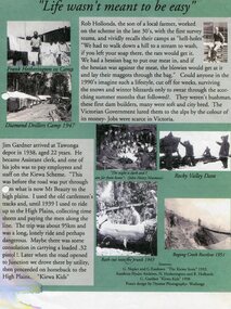
In the 1830’s, European pastoralists started moving south from NSW into the Alps. In 1836, cattle grazing began around Omeo and the runs spread out into the foothills. The higher country was used for summer grazing and huts were built for shelter and storage during stock mustering. The lure of gold brought many people to the Alps from around 1850 to 1900. Bushfires destroyed the forests around Melbourne in 1939 and the boom in house-building after World War II ked to increased demand for timber from the Alps. This resulted in the building of a network of roads which helped open up access to the Alps. The early 1940’s brought the first of many workers to the Alps for the planning and construction of the Hydro-Electric Scheme. These were the pioneers and early settlers of the Kiewa Valley and provided a wealth of characters and a tapestry of stories and adventures to be handed down to future generations.These 3 posters, which were most likely produced for promotional purposes provide a glimpse into the early lives of the pioneer families of the Kiewa Valley through pictures and verse. They show their lifestyle and outline the hardships they had to endure in living and working in the Alpine region. They also highlight the early arguments regarding grazing in the high country which would ultimately lead to the end of the long traditions of the high country cattle men. Set of 3 A4 size posters with black and white photographs and text and colour background depicting various parts of the history of the Kiewa Valley. 1. Titled - ‘Life wasn’t meant to be easy’ Describes early life for Kiewa Hydro workers. 2. Titled - ‘Cattlemen of the High Plains’ Describes a brief history of life of the cattlemen of the high plains 3. Titled – ‘There are Places I’ll remember’ Depicts early photographs of residents of the Kiewa Valley, also includes the words from a John Lennon song as per poster title. Printed on each poster – Poster designed by Dyanne Photography - Wodonga 1. Printed at bottom of poster – Sources: G Napier and G Easdown “The Kiewa Story” 1993. Southern Hydro Archives, N Hetherington and R Hollands. G Gardner “The Kiewa Kids” 1998. 2. Printed at bottom of poster – Sources: D Purland. Handwritten at top of poster- Poster 4 3. Printed at bottom of poster – Sources: B Roper, W Davies, D Higginson, H Ryder. Handwritten at top of poster- Poster 3 kiewa valley; tourism; lifestyles -
 Kiewa Valley Historical Society
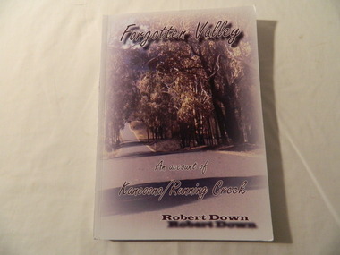
Books - History x2, Forgotten Valley An Account of Kancoona/Running Creek by Robert Down, 2011
Chapters are divided into groups of 50 years from1800 - 2010 covering the history of the area. It covers places, events families etc.Historical account contributed by local families. Soft cardboard coloured cover, with picture of road lined by thick cover of trees. 194 pages. Includes black and white photos.running creek, kancoona, kiewa valley, robert down -
 Kiewa Valley Historical Society
Postcards - Falls Creek - Set of 4
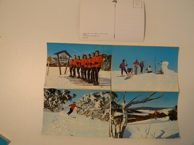
Postcards were available at tourist destinations to promote the resort by enabling visitors to write to friends and family.The Kiewa Hydro Electric Scheme hastened the development of Falls Creek as a popular destination for skiers. Roads, buildings including accommodation & chalets, ski clubs, snow vehicles, ski tows etc enabled visitors to live and ski in the snow. When construction of the KHES was completed Falls Creek continued to develop both as a winter and summer resort. Serrated edge colored postcards. 1. "On Langlauf Skis in the Australian Snowfields' - Photograph by Uwe Steinward 2. 'Ski-school and instructors at Falls Creek, Victoria' Photograph by Uwe Steinward x2 3. Overlooking the Victorian snowfields, Falls Creek, Victoria' Photograph by Uwe Steinward 4. 'Skiing down the slopes at Falls Creek, Victoria.' photograph by Uwe Steinward x3falls creek, snow, skiing, alpine sport, langlauf skmiing, uwe steinward -
 Kiewa Valley Historical Society
Papers - Jim Goonan's Story - Dederang, 1950's
Early settlers came to Dederang from Kergunyah. The main road, Dederang to Tawonga was opened about 1860 - 1864, connecting 'Crosthwaite's Gap' with 'Smith's corner'. Jim Goonan's ancestors selected land between Dederang and Tawonga in the early 1860's.A comprehensive history of the town of Dederang from the 1860's up to the 1950's. Early settlers, infrastructure, businesses, activities including sport and life style are described giving an insight into how the Kiewa Valley developed during this time.26 typed pages of the History of Dederang. Each page consists of paragraphs with a heading.dederang, jim goonan, kiewa valley -
 Kiewa Valley Historical Society
Papers - Centenary Bright-Tawonga Road, 19th March 1996
... Centre 31 Bogong High Plains Rd Mt Beauty high-country The Bright ...The Bright-Tawonga Road was built in 1896, connecting the Ovens and Kiewa valleys. The article gives an description of the event.The Bright - Tawonga road connected Tawonga to the larger town of Bright and the closest railway service. This road provided the Upper Kiewa Valley with access to larger markets, alternative transport and increased facilities not available in the Kiewa Valley in the early, pre SEC days. It describes how roads were built in 1896 with little machinery. The KVHS has in its collection the dray used to help build the road. One page article from the 'Shire News' dated 19th March 1996bright-tawonga road, road works, kiewa valley, ovens valley, dray -
 Kiewa Valley Historical Society
Papers - Bogong Village & the 'Commissioner's' Lodge & Progress Association Members, c 1997/1998
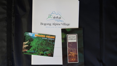
Bogong Village was built by the SECV in 1940 for the workers of the Kiewa Hydro Electric Scheme. In 1971, 30 houses were furnished for use as holiday homes for SEC personnel throughout the State. From 1989 to 1993 the houses were restored & renovated.During the 1990s the buildings in the village had been leased to private owners. Many of them rented their houses for tourists. The Commissioner's lodge was on the other side of the Mt Beauty - Falls Creek road, above Bogong Village. Wally Baldwin ran it in the 1960's.It was destroyed by the 2003 bushfires.These papers present a history of 'the Commissioner's lodge' and Bogong Village in the 1990's. The Progress Association was an active community group in 1963/64.Papers advertising Bogong Village & the Lodge for accommodation with rates 1997/1998. Describes the alternatives, maps and cafe hours, Also, 'Jan's Recollections' and on the back of these pages a hand written list of members of the the Progress Association 1963-64 as 'per Mr A. McCullough's spiel'. In original folder and includes a pamphlet & postcard.bogong village, secv lodge, lake guy, state electricity commission of victoria., kiewa hydro electric scheme, tourism, accommodation -
 Kiewa Valley Historical Society
7 small black and white photographs of Pretty Valley, c1948
In 1947 it was proposed to construct a dam on the Pretty Valley branch of the East Kiewa River. This was part of the initial planning in 1937. The Pretty Valley Reservoir was to be part of a pumped-storage scheme with a pumping station located immediately below the main structure. Preparatory work was commenced in 1946 with erection of staff accommodation. Between 1947 and 1950 the main camp was erected, access roads, constructed and banks and benches at the dam site undertaken. Following the financial crisis in 1951, a review of the scheme was carried out and work ceased in June 1951. Construction of the dam was deleted from the programme of works and all buildings removed.A pictorial history of part of the initial planning in 1937 for a dam to be constructed at Pretty Valley as part of the Kiewa Hydro Electric Scheme.7 small black and white photographs of Pretty ValleyAll photos have a circular stamp on the back with 'Print by Willson White Albury' enclosed. Photo 1 - on the back, handwritten in ink 'New 22Kv pump line - Pretty Valley Nov. 1948'. In pencil '18'. Photo 2 - On the back, handwritten in ink 'Pretty Valley - Staff mess on right Nov. 1948'. In pencil '18'. Photo 3 - On the back, handwritten in ink 'Pretty Valley Basin - looking S.E. Nov. 1948'. In pencil '5'. Photo 4 - On the back, handwritten in ink 'New pump 22Kv line, Pretty Valley - looking towards Mt. Mackie. Nov. 1948'. In pencil '5'. Photo 5 - On the back, handwritten in ink 'Pretty Valley. Mt. Cope just out of picture extreme right. Nov. 1948'. In pencil '78'. Photo 6 - on the back, handwritten in ink 'View from Pretty Valley Ruined Castle in Background Nov. 1948'. In pencil '78'. Photo 7 - on the back, handwritten in ink 'Pretty Valley Pump line (Nov. 1948)'. In pencil'78'.construct, dam, pretty valley -
 Kiewa Valley Historical Society
Projector - 'Pictoral' Bogong State School, 1925 - 1935
As Bogong State School was located in a remote area especially in winter when the weather and therefore the road isolated the school for an indefinite time, the school was provided with up to date equipment with a comprehensive library and educational films that wouldn't disadvantage the students. Educational films covered all subjects and areas of the curriculum. The projector was very modern at the time. The Society for Visual Education Inc was founded in 1919 as a for-profit educational publisher dedicated to the use of new technologies in teaching.This projector was used at the Bogong State School which opened in 1941 for the children of the employees of the State Electricity Commission of Victoria who were working on the Kiewa Hydro Electric Scheme. The school was outstanding as reported by the school inspectors regarding the education of the pupils which was also supported by new and modern equipment. The nearest school was 14 km away over a dirt road that wound around the Victorian mountains and often closed due to bad weather. Bakelite box holding a globe and a small black tin projector on brown rectangular bakelite base with 4 round rubber stands at each corner. It is able to be moved upwards from the front to adjust the height within a cm. The back is a tall irregular box shape with ventilation on 2 sides of the bottom and at the top. There is a brass plaque attached above 1 vent and an electric cord, with switch, below it. Attached at each side of the front of this box is a cylinder fitted horizontally facing the front where the lense is fitted. At right angles above there is another cylinder, hollow, with a rod for the film to be placed. Globe also in Bakelite boxPlaque: Pictorial Projector / Model Q / 120 Volts. 100 Watts / No. 23736 / Manufactured / Society of Visual Education Inc. / Chicago U.S.Aprojector, bogong primary school, education, educational films, visual education, kiewa hydro electric scheme -
 Kiewa Valley Historical Society
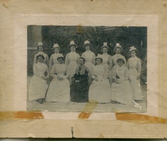
Photographs – Group of 3 old sepia photographs, 2 of women in period costume and 1 of group of nurses from Sunbury sanatorium
Europeans arrived in the Kiewa Valley in the 1830s and 40s. Following the drought of 1838-44 seeking out the rich pastures in the fertile Kiewa Valley. . The next major increase in population was as a result of the Kiewa Hydro Scheme. The beginning of construction of the Kiewa Hydro-electric scheme in the late 1940s introduced changes and led to the enlargement and improvement of local roads and the townships of Mount Beauty and Bogong Village were constructed by the SECV from the 1930’s to the 1950’s to house workers on the Kiewa Hydro Electric Scheme. At its peak the Kiewa Scheme employed around 4000 people from all walks of life and as many cultures.The influx of European migrants to work on the Hydro Scheme along with their rich cultural backgrounds, all played a major part in establishing the history of the area and in shaping the future character of the Mount Beauty, the Kiewa Valley and Falls Creek areas. Photographs may depict descendants, family or friends of early settlers or workers in the Kiewa Valley region.1. Sepia photograph, mounted on heavy buff card with yellowing marks from sticking tape across the bottom of the photograph. Photograph is of a group of nurses taken at the Sunbury Sanitorium 2. Sepia photograph mounted on heavy buff card with yellowing marks from sticking tape at top and bottom of photo. Mark from drawing pin in centre top of photo. Photograph is of a middle aged woman posing dressed in period costume 3. Sepia photograph mounted on heavy buff card with yellowing marks from sticking tape at top and bottom of photo. Mark from drawing pin in centre top of photo. Photograph is of an older woman posing dressed in period costume sepia photos; nurses; kiewa valley; sunbury sanitorium; period costume -
 Kiewa Valley Historical Society
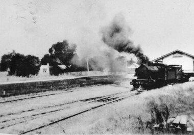
Photographs – Set of 3 black and white photographs of a building being transported by steam train
Prior to the sealing of the Kiewa Valley Highway in 1950, all heavy road stock including building materials, farm equipment and other heavy machinery had to be transported via railway lines to either Albury, Wodonga or Bright and then transported overland for the remainder of the distance by wagon on rough, poorly made roads. Trains also services the mining industries of the Ovens Valley and the transportation of tourists to Mount Buffalo and the very popular Mount Buffalo Chalet.Steam trains were a major form of transport for rural community members prior to the introduction of road transport. Local producers including farmers relied on rail transport to send and receive essential building equipment, farming produce, materials, stock and mail to maintain their lifestyles and social connections with the outside world. 3 black and white photographs of a building being transported by steam train. Photos show the train in three progressively closer photos. Photo shows a man standing in the doorway at the controls of the train, 3 figures, possibly children leaning out of the window of the carriage and another man, standing on the tracks with hands on hips. Photo could have been taken in Tallangatta, Cudgewa or Ebden near Lake Hume where trains were a major form of transport prior to the 1950’s. No markingstransportables; steam train; railway;, old tallangatta, esther temple -
 Kiewa Valley Historical Society
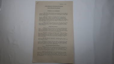
Papers - Kiewa Hydro Electric Scheme, State Electricity Commission of Victoria / Kiewa Hydro Electric Project / Progress of the Undertaking, November 1953
The SECV constructed the KHES from 1939 to 1961 on the Bogong High Plains. It included work on Power Stations, Dams, Tunnels, Race-lines and transmission lines as well as camps, towns, roads, telecommunications and infra structure. These papers give an understanding of where the project was up to in late 1953. These papers give information on the KHES on the aspects of work, its progress and technical detail.3 foolscap pages, stapled in the top left hand corner. Each page has sub headings re the progress of the works being undertaken on the Kiewa Hydro Electric Scheme.state electricity commission of victoria; kiewa hydro electric scheme; power stations; dams; tunnels; bogong high plains -
 Kiewa Valley Historical Society
Leaflet - Kiewa, Welcome to Kiewa
The State Electricity Commission of Victoria constructed the Kiewa Hydro Electric Scheme from 1938 to 1961. The Scheme included three power stations, dams, tunnels and was becoming a popular tourist destination with Falls Creek Ski field within its boundaries.This leaflet was published by the SECV to ensure all visitors to the Kiewa Hydro Electric Scheme were made aware of safety measures with regard to their driving and to bush fires. These were necessary as the area was unique with driving on mountainous roads, changeable and extreme weather and the threat of bush fires. The gatehouse existed during construction, when the SECV was in charge, as a restriction to entry to the Scheme for SECV workers and those with permission to enter. The SECV controlled the area so in case of accident, the SECV was the body to contact not eg. the police.Small white and green leaflet made from one sheet of glossy paper and folded in half. Front cover has the title in the middle, the SECV emblem at the centre top and across the bottom is a message to read the inside pages which are safety messages for driving and bush fires. The back cover has a RACV road map of Kiewa and its 'works' including the Gatehouse which was the entrance to the scheme.The map also has an insert of the main roads & nearby cities. state electricity commission of victoria; kiewa hydro electric scheme; gatehouse; safety rules; kiewa -
 Kiewa Valley Historical Society
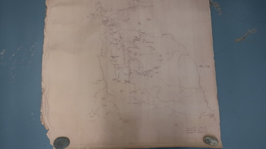
Map - Bogong High Plains
Bogong high Plains showing mountains, places, roads and riversHistorical changes of infrastructure on the Bogong High PlainsBogong High Plains, hand written and 'copied with considerable simplification from F.C.V. (Falls Creek V.?) 'Feathetop' L 'Tawonga'. Paper is yellowed, writing is brown.bogong high plains map -
 Kiewa Valley Historical Society
Maps - Tawonga and Feathertop
Plan of Tawonga showing roads etc, rivers, use of land in 1968 and of Feathertop in 1969.Historical use of land in Tawonga and Feathertop.1. Topographical Map - Tawonga 803 Forests Commission of Victoria 1968. Cream paper with black print. Legend: Roads, tracks etc, rivers, Parishes and use of land. 2. Feathertop 813. 1969tawonga map 1968, tawonga parishes, feathertop map 1969 -
 Kiewa Valley Historical Society
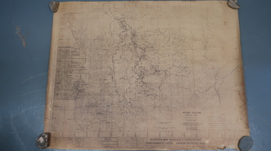
Map - Kiewa Scheme General Plan
Existing and possible future roads are numbered and named 1 - 45. The plan is based on an aerial photos taken March 1945. It includes revisions up to 1951. Signed by H.H.C. Williams, construction engineer. Mountains, rivers, roads and SECV places are named, also SECV infrastructure and construction eg. workers camps, Power stations.Significant for the information re the Kiewa Hydro Electric Scheme's development.Yellowed paper with brown print. Kiewa Scheme general plan showing its development. A lot of information is recorded. Note: Dyeline print was used which causes fading when exposed to light. Handwritten: 'Bob Duncan'bob duncan, kiewa hydro electric scheme, secv, khes development -
 Kiewa Valley Historical Society
Scales Weighing Pocket, circa early 1900s
Historically this item would have been used by gold miners, rabbit shooters, mobile "Rag and Bone" traders and other mobile(in caravans and/or horse drawn cart) traders of various small goods and haberdashery. Although marked as not to be used as trade, the isolation and sometimes difficult terrain rules out using larger and more delicate scales. In the early 1900s rough roads and severe weather conditions forced traders to be more flexible in trading with weights and measures. The "close enough is good enough" doctrine was the Australian outback rule of thumb.The significance of this item in the Kiewa Valley during this period demonstrates the slower acceptance of accurate trading measure using the country side principle "my hand shake is my bond". In the Kiewa Valley small quantity commercial undertakings e.g. gold mining, fur pelts and rabbit meat trade did not require bulk weight type scales. Commerce in rural production e.g. fruit and vegetables involved more farmers and their staff in a barter and/or "in kind" payments. This was more so in the depression years 1929 to late 1930s. Self sufficiency was to a large extent more attainable in this region than in the city/ large country town environment. The Australian "fair go" ethical approach to life and commerce was very much ingrained in those living in country regions, like Kiewa Valley as is demonstrated by the not so accurate hand balance, spring loaded scales.This brass "faced" portable Pocket Balance ( Fish Scales) has front plate made from thin pressed brass. The mild steel spring mechanism enclosed by black painted medium gauge steel cover( three quarters cylindrical). Front scale face and rear spring casing fastened by three rivets. Spring loaded marker blade is located in the centre of the front plate. A steel " finger holder" ring is attached at the top of the scale unit from one of two pre drilled holes. The top is for holding the scale upright and the bottom for a hook to dangle the item to be weighed from the bottom. See item KVHS 0223 for similar scales"THE BILLY BALANCE" and at the bottom "MADE IN GERMANY"antique pocket balance, scales, mobile weights, vintage appliances -
 Kiewa Valley Historical Society
Bibs - Bogong Primary School
Bogong Primary School opened in 1941 to provide an education for the employees of the State Electricity Commission of Victoria. The school had up to date equipment and received glowing reports from school inspectors. It closed c1986.The Bogong State School was opened for the children of S.E.C.V. workers who lived in Bogong in a remote part of north east Victoria. The nearest school would have been 14 miles away and over mountain roads subject to heavy construction traffic and extremes of climatic conditions.6 bright orange 'bibs' from Bogong Primary School. Used to identify a team in eg. sport. Each bib has 2 coloured squares which are hemmed and joined to each other with 2 elastic pieces on the outside at the top (to fit over the head) and on each square joining the 2 squares, 2 white bias binding pieces on the outside at the bottom (for the arms to go through.)team bibs. bogong primary school. education. state school. -
 Kiewa Valley Historical Society
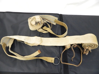
Seal Skins Ski Straps / Soles
Seal skin straps and webbing were introduced into the Victorian Alps by European skiers. Enthusiasts travelled to enjoy the snow and to explore the Victorian Alps including the Bogong High Plains. This equipment enabled them to travel over snow without slipping when going up hills. They took the skins off when they wanted to slide down hills. In later years, waxes were used for cross country skiing and then 'fish tail' markings on the back of skis to enable skiers to travel distances up and down mountains. Later developments also included motor transport (replacing horses to get to the snow line) and roads to take skiers to the ski fields and mechanised tows to take skiers up mountains so they could ski down (downhill skiing). Skate skiing has also developed as another form of skiing.Skiers visited the Bogong High Plains during summer and winter to explore and enjoy the High Plains. The equipment used was a forerunner to the variety used today and the different types of skiing done today. Falls Creek was developed during the construction of the Kiewa Electric Hydro Scheme and was influenced by the number of Europeans working on the scheme and their desire to make use of the snow during winter.Each Seal skin has: Seal skin sewn onto one side of a strap of webbing. There is a webbing loop on the front that slips over a small point at the front of the ski. There is a webbing strap attached to the back of the seal skin sole coming over the back of the ski that clips metal fasteners onto a loop of webbing behind the boot.skiing. snow. high plains. seal skins. cross country skiing. alpine sports. -
 Kiewa Valley Historical Society
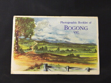
Booklet - Bogong, Photographic Booklet of Bogong Vic
This booklet was produced to advertise Bogong Village and surrounding areas. The photos depict the area's buildings and equipment being used at the time. Bogong Village housed the State Electricity Commission of Victoria's employees working on the Kiewa Hydro Electric Scheme which began in the 1930's and finished in the 1960's. Maisie describes her visit in May 1958 giving an insight into the area including the weather and the roads.The photos indicate what the area around Bogong looked like c1958 towards the end of construction but before the bush grew back after the 1939 fires at Bogong village and after construction of the shopping centre at Mt Beauty. A sno' cat and snow plough are also shown emphasising the change in machinery over the years. This enables comparisons to be made in many areas of study.A fold down booklet postcard size of 9 black and white photos of Bogong village and surrounds and a letter addressed to Mrs. A. Parnell of Sydney from Maisie. Maise's husband has 2 married sisters living near Bogong on farms. The booklet is in a clear plastic sleevePostage stamp arrived in Sydney 28th May 1958.bogong. lake guy. howman gap hostel. mt beauty.bogong high plains. -
 Kiewa Valley Historical Society
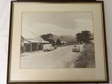
Photo - Tawonga Store
This photo was taken in the 1950's when Pearce Bros. owned the Tawonga Store. I.R.Northey's van is parked outside the store. Kodak photos are advertised. The Bakery existed. The road is sealed and telephone and electric wires are shown. The Pearce Bros owned the Tawonga Store in the 1950s when the population of the area in the Upper Kiewa Valley and High Plains was high due to the construction of the Kiewa Hydro Electric Scheme by the State Electricity Commission of Victoria.Sepia photo of Pearce Bros. Tawonga Store including a house next door, cars in the sealed street and part of the Bakery opposite. It has a slim wooden frame & white cardboard border. It has a clear glass cover. The back is lined with brown paper with a white cord across for hanging the photo.tawonga store. pearce bros. tawonga bakery. i.r.northey. -
 Kiewa Valley Historical Society
Letters - Briggs Bros
The Briggs family lived in Tawonga. Thomas assisted building the Tawonga to Bright road and drove cattle to the Bogong High Plains before marrying in 1887 and raising 7 children, 2 of whom, Ernest and Albert enlisted in WW1 in 1916. Their letters from the war give an insight into its effects and the attitude of the time.The Briggs Bros. lived in the Kiewa Valley at Tawonga. Their letters give an insight into the war and an understanding of the times. Their parents lived and worked locally further enriching an understanding of the history of the Valley.30 pages of photocopies A4 size, of the Family Tree of the Briggs Family of Tawonga, including letters from two brothers from the trenches in WWI..briggs bros.. ww1. letters. tawonga. briggs family. droving. bright road. bogong high plains. -
 Kiewa Valley Historical Society
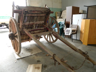
Tipping Dray
The dray was pulled by a horse and used to transport road building materials such as gravel. The tray carried 0.7 of a cubic metre which would have weighed about 1 tonne (varying on the load being wet or dry).This tipping dray was owned by John Briggs who carried gravel on the Tawonga to German Creek Road from 1894 to 1895. Workers were paid 2/- (shillings) per day to cover sections that were called 'a paddock' resulting in workers finishing at 10 or 11 pm. The road opened on the 17th March 1896 at a cost of 1700 pounds. See KVHS 0960 for newspaper article re Tom Briggs and making (and photo) of the Tawonga Gap road.Old single axil wooden dray with wooden spoke wheels and a tipping wooden tray.tipping dray. john briggs. tawonga. german creek. road building. transport. -
 Kiewa Valley Historical Society
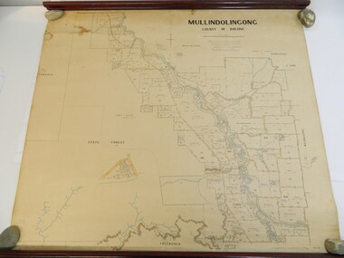
Map - Kiewa Valley, Parish Map of Mullindolingong, 12/10/1906
The map shows the names of people living in the parish of Mullindolingong in 1906. These people had leases or licences giving the reader an insight into the number of people in the area and an understanding of the size of their holdings. Infrastructure is also given including shops, schools, churches etc. Presumably it was used by the Ryder family.This map gives an historical insight into the parish of Mullindolingong as it names people and the infrastructure - roads, buildings etc. as it was in 1906. This enables the reader to compare the area at the time with other times and other places and to have an understanding of the early settlers in the area.This is a very old paper or parchment map with wooden rods top and bottom. The top rod has ribbons attached to enable hanging. The map shows the current leases and licences and when they were held by during this period, circa 1906.Mullindolingong County of Bogong. This plan has been prepared by The Most Reliable Data in the Possession of the Department up to the date of its Compilation. Information respecting Leases or Licences which await Final Completion is not recorded.parish of mullindolingong map; ryder family; early settlers; -
 Kiewa Valley Historical Society
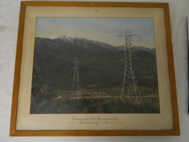
Framed photo - Mt Beauty Township & Main Transmission Line, 1954
This is a photo of Mount Beauty taken from a high vantage point near the hair-pin bend on the Tawonga Gap Road (half way up) in 1954. Mount Beauty was built by the State Electricity Commission of Victoria during the construction of the Kiewa Hydro Electric Scheme.This photo belonged to Mr & Mrs Gordon White SECV employee and long time residents of Mt Beauty.This is a framed coloured photo of the Mount Beauty Township and main Transmission Line from Mt Beauty to Kiewa. The photo has two transmission lines in the foreground with the Mt Beauty township in the background, but at the foot of Mount Bogong.Approx 1954 / Conroy-Moffatt Pty Ltd / Picture Framer / ..McKillop Street / Tel Mu .. 78 ....mt beauty; transmission line; tawonga gap road; kiewa hydro electric scheme -
 Warrnambool and District Historical Society Inc.
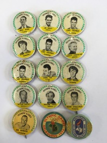
Badge - Melbourne Olympic Souvenir 1956 Badges x 15, 1956
The Melbourne Olympic games were mainly conducted at the Melbourne Cricket Ground and were one of the most successful in terms of medals for Australia. Among the medal winners were Shirley Strickland, Betty Cuthbert in Athletics and Dawn Fraser and Murray rose in swimming. The games commenced in November 1956. The games were noted for the 19 Hungarian athletes who applied for asylum with their home country undergoing upheaval at the time. The Melbourne games also enjoyed the advent of television with the technology having recently been introduced to the country. These badges note ten of the many athletes who competed for Australia in 1956. These items are of social significance and interest. Among the names listed, Dawn Fraser and Shirley Strickland were two of Australia’s best known athletes.001042.1 Dawn Fraser Swimming 001042.2 Dawn Fraser Swimming 001042.3Gary Chapman Swimming 001042.4Gary Chapman Swimming 001042.5Gary Chapman Swimming 001042.6Jim Bailey Athletics 001042.7 Winsome Cripps Athletics 001042.8 Lionel Cox cycling 001042.9 Hector Hogan Athletics 001042.10 Kevin O’Halloran Swimming 001042.11 Shirley Strickland Athletics 001042.12 Merv Wood Sculling 001042.13 Jon Henricks Swimming Items 001042.1-001042.13 are white background with green wreath , black text on yellow background and have B & W photo of Olympian in centre. 001042.14 Melbourne Olympics Souvenir dark blue text, pale green with wattle 001042.15 Melbourne Olympic Games 1956 with red text Straight pin at the back. Patrick Pty Ltd on edge.1956 olympics, melbourne olympics, souvenir badges, dawn fraser, gary chapman, jim bailey, winsome cripps, lionel cox, kevin o'halloran, hector hogan, shirley strickland, jon hendricks, merv woods, melbourne olympic games -
 Warrnambool and District Historical Society Inc.
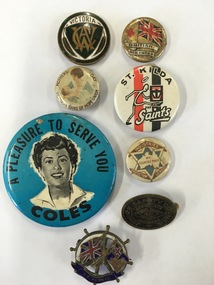
Badge - Badges x 8, Collection of various badges
These badges reflect various aspects of life in Australia and the many allegiance which people have to organisations from the Country Womans Association, to football clubs, with groups such as the Industries Protection league and Temperance groups such as the Band of Hope Union espousing interests and ideas in the early to mid 20th centurySocial significance001048.1 CWA badge Round metal badge with dark green rim surrounding monogrammed shield and gum leaf on either side. Victoria in bronze at top of shield. Stokes **** Melb on rear. 001048.2 British Red Cross. Round tin badge with Union Jack flag and red cross on left with text in banners below flag. 001048.3 Victorian Badge of Hope Union. Small button badge with cream background, brown text around edge with image of mother and child in blue tones in the centre 001048.4 St Kilda Football badge. Round tin plastic coated. White background with image of saint emblem on front on background of club colours. 001048.5 Coles Badge. Large button badge with bright blue background with image of lady in black and white in the centre. Text in black. 001048.6 Industries Protection League. Small cream plastic badge with outline of Australia inside a star. Brown boomerangs top and bottom. 001048.7 Junior safety Council. Oval metal badge. Black with brass text and artwork. 001048.8 S.S. Persis. Three dimensional with ship’s wheel at back in white and Australia and British flags in foreground with S.S. Persic on banner below flags. warrnambool history, industries protection league badge, band of hope union badge, s s persic badge -
 Warrnambool and District Historical Society Inc.
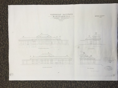
Map, Victorian Railway W'bool No1 & No2, 1897
These two sheets show the 1897 plans drawn up by the Victorian Railways for the erection of the Warrnambool Railway Station building. It is a two-storey building still existing today. The railway came to Warrnambool in 1890 and they must have used temporary buildings for seven years before this railway building was erected. It had offices, booking counter and public facilities on the ground floor and housing for the Station Master on the first floor. The building erected was a typical design for country town railway stations and many of similar design were erected in the 1880s and 90s. These plans are important because they show clearly the design of the Warrnambool Railway Station buildings when they were first erected in the 1890s.They will be very useful for researchers. The coming of the railway was a significant event in Warrnambool’s history and did much to make the port and shipping a less viable proposition.These are two architect’s plans and drawings of the Warrnambool Railway Station building (1897). The drawings are black and white and the first plan shows the ground floor plan and the first floor plan and the outbuildings. The second plan shows drawings of the building with its elevation to the platform and its elevation to Merri Street. There are two stamps of the Railways Department, Melbourne. These are copies, not originals. ‘Victorian Railways, Warrnambool, Station Buildings, Scale 8 feet to one inch, Contract No. 6379B (Nos. 1 and 2)’warrnambool, railway station buildings