Showing 512 items matching "soil"
-
 4th/19th Prince of Wales's Light Horse Regiment Unit History Room
Card - Christmas Card, 1915 (exact)
Service of Frank Phillips Prior to the commencement of World War I, Frank Phillips served in the Minyip Troop of the Light Horse militia. His civilian occupation was that of clerk. On 22 August 1914 he enlisted in C Squadron 4th Light Horse Regiment. The 4th Light Horse Regiment embarked on the troop ship “Wiltshire “ for training at Mena Camp, in Egypt. During May 1915 the Regiment was deployed to the Gallipoli campaign in a dismounted role. After seven months, the Gallipoli campaigned was abandoned and the troops withdrawn. On return to Egypt the 4th Light Horse Regiment divided with one component deployed to Palestine and the other to the Western Front. Frank went on to serve in Palestine. He was promoted to Sergeant while at Gallipoli and, in Palestine, was promoted to Captain, serving as Adjutant of the Regiment. He was granted furlough to return to Australia from 14 October 1916 to 12 March 1917. On 16 January 1918 he was Mentioned in Despatches Citation: At Hill 750 near Bir El Esani on 30-4-17 he led an attack on Hill 750 under heavy rifle fire capturing the position and 7 armed Bedouins. On 23-5-17 during reconnaissance, he led and attack on 790 under very heavy rifle and machine gun fire and captured the position, inflicting losses on the Turks. He has, at all times, set a fine example of courage to his men. 22 October: 1918 he was awarded the Military Cross Recommendation of Commanding Officer – For exceptional gallantry and devotion to duty on the 28th September 1918, during the crossing of the JORDAN near EL MIN, this officer (adjutant of the Regiment) personally reconnoitred for crossings under heavy M.G. fire and led the Regiment to the only available crossing, rendering invaluable assistance during the crossing. On 3oth September when the Regiment was advanced guard on to KAUKAB, this officer’s personal reconnaissance to confirm patrol reports was of the highest order and utmost value to his C.O. culminating in the capture of KAUKAB with a mounted attack and the The 4th/19th Prince of Wales’s Light Horse Regiment has a long and distinguished history that pre-dates Federation to colonial Victoria’s mounted troops. Our history parallels that of the nation, including its active participation in some of the most inspiring events in Australian Military History including the Defence of ANZAC and the charge at Beersheba. The Regiment is based on a linkage of the two post-World War II Victorian Army Reserve RAAC units - 4th/19th Prince of Wales’ Light Horse and 8th/13th Victorian Mounted Rifles. From these units we derive our links with the six Light Horse Regiments of Victoria and Southern New South Wales (4th, 8th, 13th, 17th, 19th and 20th Light Horse Regiments.) The Regiment proudly bears the guidon of the 4th Light Horse, with the guidons of the remaining regiments being laid up in the crypt of the Melbourne Shrine of Remembrance. During World War I, the 4th Light Horse Regiment served with distinction on three fronts – Gallipoli, Palestine and the Western Front. Corporal, later Captain, Phillips was a member of the 4th Australian Light Horse Regiment. He created the post card while serving with the Regiment as a Corporal at Gallipoli. Post Card hand made and sent to familyFrom Cpl Frank Phillips, 4th Australian Light Horse Regiment. Entries in pencil Front: Addressed to Andrew Phillips (father) at Minyip, Victoria, Message: “A Merry Christmas and Happy New Year to all, Made while on my day out. Love Frank” Reverse Top Centre – 4 LH Badge Centre – cloth map of Australia stapled to card Bottom – Print of flag stapled to card, Irish green ensign, Union flag in canton, gold coloured Irish harp on fly. Notations: Broadmeadows, Wiltshire (Troop Ship), Shrapnel Gully, Suicide Gully, Courtney’s Post Mena, Mex, Heliopolis, Imbros, Gallipoli, Turkish soil underneath (flag), Australia on Turkey, Lone Pine, Leans Trench, Constantinople, All honour to our Irish comrades, To greet you 1915-16. From the shells, yells, and little Hells, of the Darda Dardenelles 0 – 0 May you enjoy your Xmas dinner as I hope to enjoy my Xmas billy in the trenches.ww1, gallipoli, 4th light horse, post card, frank phillips -
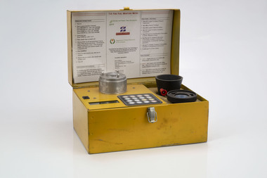 Department of Energy, Environment and Climate Action
Prototype fuel moisture meter
Bushfire behaviour is influenced by many things including temperature, relative humidity, forest type, fuel quantity and fuel dryness, topography and even slope. Wind has a dominant effect on the Rate of Spread (ROS), and also bushfire size, shape and direction. Fuel arrangement is as important as fuel quantity (tonnes/ha). Fibrous and ribbon bark, together with elevated and near-surface scrub fuels act as ladders which lead flames into the tree canopy. But the availability of fuel to burn depends largely on its moisture content. When it exceeds 20-25% not much will burn, whereas 12-15% is generally ideal for fuel reduction burning, but if the moisture content drops as low as 7-10% virtually everything will ignite, and fire behaviour becomes extreme. During the afternoon of the Ash Wednesday bushfires on 16 February 1983 fuel moisture contents were recorded at Stawell as low as 2.7%. Fine fuels like leaves and bark can rapidly absorb moisture after a shower of rain, or from the air when the Relative Humidity (RH) is high, and the temperature is low. Conversely, they can also dry out very quickly. So even though the overall fuel quantity in the forest doesn’t change, the fine fuel availability can increase rapidly from zero after rain to many tonnes per hectare as the fuel dries out. This can happen over a few hours on hot and windy days. Heavy fuels like logs on the ground take longer to dry out. Since the 1930s foresters, firefighters and researchers have been working to develop quick and reliable techniques for measuring fuel moisture content. One of the most accurate methods is slowly drying a sample of fuel in a conventional oven for 24-48 hours to remove all the moisture and measuring the weight difference, but this takes time and is not practical in the field when rapid measurements are needed. But oven drying is often used as a benchmark to compare other methods. Microwave ovens are faster but can cause uneven drying and even char the fuel. They are also not very practical for use in the field. Some mathematical models rely on weather records such as rainfall, wind speed, evaporation, cloud cover, shading, relative humidity, slope, aspect and season of the year to predict soil and fuel moisture. The Keetch-Byram Drought Index of soil dryness is the most common. But complex fuels with leaves, twigs, grass etc make the predictive models often inadequate for fine fuels. The most common technique in Victorian forests until recently was the trusty Speedy Moisture Meter. Originally developed in England during the 1920s for measuring moisture in wheat and other grains it was adapted for Australian forest fuels in the 1950s (I think). Fuel was first ground using a Spong mincer, often attached to the bullbar of a vehicle, and a small sample placed into the Speedy together with a measure of calcium carbide and then sealed. A chemical reaction created gas pressure which was read on the external dial. There were important techniques with cleaning, mincing and using the chemicals with the Speedy to give reliable readings, but it was quick, inexpensive, robust, portable and practical in the field. It was used routinely before igniting a fuel reduction burn or measuring fuel moisture differentials on slash burns. But in about 1996, Karen Chatto and Kevin Tolhurst from the Department’s Creswick Research Station developed the Wiltronics Fuel Moisture meter which measured electrical resistance. Wiltronics is an Australian owned company operating from Ballarat. The final result was a kit that was portable, accurate and could reliably measure fuel moisture contents between 3% and 200%. Although expensive, it is now widely used by fire agencies around the world which has virtually relegated the Speedy to the back cupboard.Prototype Fuel moisture meterT-H Fine Fuel Meterforests commission victoria (fcv), bushfire, forest measurement -
 Southern Sherbrooke Historical Society Inc.
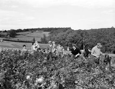
Photograph - Spykers family at Avonsleigh c.1960
Black and white photo showing a large family group in a flower field. In the background there are low hills with cleared paddocks and forested areas. According to the National Archives of Australia: 'Land was life for nurseryman Theo Spykers and his ancestors who had tilled the soil for generations; good land to own and to pass on to sons and their sons. At 42 Theo had one and a half acres near Rotterdam for a prosperous nursery, but he could only rent it and his family was growing. So, in 1948, Theo left his wife and six children at their home and set off by himself for Australia. Within a year he had paid a deposit on a broken-down property of 35 acres in the Dandenong ranges. His family joined him and they started to rehabilitate their new property. Mr and Mrs Spykers and twelve of their thirteen children pick chrysanthemums for sale in Melbourne, a city of 1,750,000. The children are; Theo, 20; Gerald, 15; Niko, 8; Frank, 5; Adolf, 22; Corrie, 11; Ria, 18; Terisa, 4; Anthony, 7; Tommy, 2; Elly, 10; Bill, 16.' Mr & Mrs Spykers are each holding one of the smaller children. This farm was on the corner of Birds Rd and Avon Rd, Avonsleigh. On the NAA records, Theodorus Gerardus Spykers arrived in Melbourne on the Muiderkerk on 27th February 1948. Black and white photo showing 15 year old Gerald Spykers carrying bundles of chrysanthemums tied ready for market. He is at the family farm on the corner of Birds Rd and Avon Rd, Avonsleigh. -
 The Beechworth Burke Museum
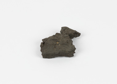
Geological specimen - Brown Coal
Brown Coal is typically found as rocks. During formation the Brown Coal starts as peats, which is an acidic brown deposit resembling soil, and over time when subjected to pressure and heat these peats form the Coal. Brown Coal is the lowest rank of coal as it has a low carbon (energy) content, and a high moisture content. This high moisture content makes Brown Coal unsuitable for overseas exports. This particular specimen was recovered from the Yallourn Mine in Latrobe Valley, Victoria as part of the geological survey of Victoria being carried out by Alfred Selwyn. Otherwise known as the 'Yallourn Power Station', the Yallourn Mine is Australia's second largest mine. Yallourn Mine was first built in 1920, and since then it has been providing over 1 billion tonnes of Brown Coal to Australia every year. The Yallourn Mine is responsible for 22% of Victoria's electricity and 8% of Australia's electricity. As of 2021 the mine employs around 500 people. Due to ongoing maintenance issues and Australia's move to cleaner energy, the Yallourn Mine intends to shut down permanently as of 2028. Soon after gold was discovered in 1851, Victoria’s Governor La Trobe wrote to the Colonial Office in London, urging ‘the propriety of selecting and appointing as Mineral Surveyor for this Colony a gentleman possessed of the requisite qualifications and acquaintance with geological science and phenomena’. Alfred Selwyn was appointed geological surveyor in Australia in 1852 which began the Geological Survey of Victoria. In 1853-69 the Geological Survey issued under Selwyn's direction sixty-one geological maps and numerous reports; they were of such high standard that a writer in the Quarterly Journal of the Geological Society of London bracketed the survey with that of the United States of America as the best in the world. During his years spent in Australia, Selwyn collected numerous significant geological specimens, examples of which are held in collections such as the Burke Museum.Brown coal is considered to be an essential rock to Australia's energy consumption. Although plentiful in sources, Brown Coal is not able to be exported overseas due to its high moisture content. As Australia moves towards cleaner energy, Brown Coal is going become less used. This specimen is part of a larger collection of geological and mineral specimens collected from around Australia (and some parts of the world) and donated to the Burke Museum between 1868-1880. A large percentage of these specimens were collected in Victoria as part of the Geological Survey of Victoria that begun in 1852 (in response to the Gold Rush) to study and map the geology of Victoria. Collecting geological specimens was an important part of mapping and understanding the scientific makeup of the earth. Many of these specimens were sent to research and collecting organisations across Australia, including the Burke Museum, to educate and encourage further study.A solid hand-sized sedimentary rock that is a dark shade of brown.13 / BROWN COAL / Showing Woody structure / Locality: Yallourn, Vic. | Label probably / correct but / can't find reference / no. 13 to match in / registers. / C Willman / 15/4/21burke museum, beechworth, indigo shire, beechworth museum, geological, geological specimen, mineralogy, yallourn, yallourn mine, victoria, coal, brown coal, brown coal specimen, alfred selwyn, geological survey of victoria, geological survey, yallourn power station -
Glen Eira Historical Society
Document - History of the City of Caulfield
This file contains 4 items: 1/Typewritten document titled ‘The City of Caulfield’. Author and date unknown. 1 page (back and front), 2 copies. Document covers topics such as origins of the name ‘Caulfield’, early settlement and the Caulfield Cup. 2/Typewritten document titled ‘History of Caulfield Council’. Author and date unknown. 6 pages, 3 copies. Document covers subjects such as early settlement, Aboriginal influence, Caulfield Road Board, Shire of Caulfield, Borough and town boundaries, coat of arms, and Freedom of Entry to the City. 3/Typewritten document (undated + author unknown) titled ‘The Structure of Local Government in Victoria with a history of the City of Caulfield’. 13 pages. Covers the following subjects: Powers, Planning, Public Works, Trading Undertakings, Health Services, Municipalities, Wards Electors or Ratepayers, Voters Roll, Councillors, Officers, Finance, Nature of Soil and Vegetation, Parks and Gardens and Reserves, Coat of Arms, Boundaries, How Did Caulfield get its Name, Aboriginal Influence, Caulfield Road Board, Shire of Caulfield, Borough and Town and the City of Caulfield. Also covered is early settlement. Note at the end of the document mentions that the historical content contained in the last section was based upon a thesis for the Department of Town and Regional Planning, University of Melbourne, 1968 by L. Alwis, P. Rowe, N. Wootten. Melbourne, ‘City of Caulfield: An Illustrated City Report’. 4/Typewritten document (undated) titled ‘The Structure of Local Government in Victoria with notes on the history of the City of Caulfield’. 8 pages, 2 copies. This document also includes a map/diagram of the city with boundaries and wards showing locations of railway stations and parks. Document covers the structure of local government and its functions then goes on to focus on City of Caulfield with subjects similar to those covered in item 3. Document signed off by Deputy Town Clerk.city of caulfield, caulfield john, caulfield baron, caulfield racecourse, elsternwick, ripponlea, st. mary’s church, caulfield council, kooyong road, neerim road, bambra road, greenmeadows house, caulfield park, paddy’s swamp, dandenong road, caulfield grammar school, chisholm institute of technology, murrumbeena, glen eira road, alma road, orrong road, balaclava road, inkerman road, ‘grosmont’, caulfield school room, caulfield road board, caulfield road district, crimean war, victorian amateur turf club, caulfield cup, glenhuntly road, north road, glenhuntly station, ormond station, outer circle railway, local government, gardenvale, carnegie, rosstown, poath road, nepean highway, hotham street, ormond park, princes park, ross william murray, caulfield institute of technology, ‘ross’ folly’, hawthorn road, glenhuntly, ormond, morris t. w., lloyd charles du plan, meals on wheels, shire of caulfield, caulfield railway station, caulfield rsl, bouran road, murrum murrumbeen, kooyong road, great dandenong road, neerim road, trams, prahran and malvern tramways trust, fisher andrew, mackinnon reserve, dover street, ‘glen eira’, blair max cr., insignia, third ordnance services unit, schools, street lighting, lampriere, mr. bevan, the caulfield leader, davies j. henry, curraweena road, st. georges road, o’neill college, hope george, market gardens, koornang reserve, packer reserve, murrumbeena reserve, hopetoun gardens, greenmeadows gardens, mirambeena, caulfield technical college, hart john, langdon h. j., ‘rosecraddock’, judge webb, ‘crotonhurst’, service james, ‘kilwinning’, ricketson henry, grimwade frederick sheppard, airdrie, jenner, st. aubin’s, caulfield john p. t., harlston, lempriere, lord reserve, ‘cantala’ -
 Falls Creek Historical Society
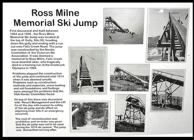
Mixed media - Ross Milne Memorial Ski Jump
Ross Milne grew up on his family's tobacco property in Myrtleford, and began skiing at Falls Creek at an early age. He was taught by Austrian Sigi Haberzettl, who was chief coach at Falls Creek for 17 years. Ross went on to win the North-Eastern District Ski Association (NEDSA) Junior Championships for three consecutive years. In 1961 Ross was a member of the Australian team which competed against New Zealand in the Inter-Dominion Championships. In 1963, he won the Downhill and Alpine Combined title at the Australian Championships, while placing second in the Grand Slalom event. Ross was selected in the Australian team that participated in the 1964 Olympic Winter Games at Innsbruck, Austria. A few days before the opening of the Games, on 25th January 1964, he tragically lost his life when he crashed into a tree during a training run for the Men's Downhill. He was only 19 years of age. The construction of the Ross Milne Memorial Ski Jump was first discussed and built between 1964 and 1966. It was located at the top of Gully, Site 99, heading down the gully and ending with a run out onto Falls Creek Road. The Jump was constructed by the Nordic Committee of the Victorian Ski Association. Problems plagued the construction of the Jump and continued until 1974 when it was deemed unsafe. Problems such as construction methods and materials, snow loading and soil foundations and footings were some of the issues which the VSA Nordic Committee faced. On top of this there was discontent with Resort Management and the Lift Company of the day with respect to safety of the Ski Jump and its effect on adjoining chair lifts if an emergency should occur. The cost of reconstruction was prohibitive and an order was given that the SkiJump was not to be used during the 1974 ski season. The Jump was dismantled not long after.These items are significant as they document the development of a memorial to an Australian Olympic Skier, Ross Milne.A collection of documents and photographs documenting the construction of the Ross Milne Memorial Ski Jump built at Falls Creek in 1966. A display board including photographs and explanatory text is part of this collection.ross milne, ross milne memorial ski jump -
Stawell Historical Society Inc
Realia - Calender, Brambuk Visitor Centre, A Year in Grampians - Gariwerd
Perpetual Calender. With eight proposed seasons according to Indigenous AustraliansOn a backgrous of Blurred of white and red Flowers "A Year in the Grampians Gariwerd". A Photo of the Grampians across farmland "This Calender combines Australian and European traditions" "Indigenous Australians observe changing weather and environmental patterns and resulting cycles of local seasons. On Each page of this calendar the large scene photos were taken in that month, over a period of twenty years. ( It must be remembered that flowers vary with the elevation, the soil, the aspect and the weather from year to year. You will not always find the same flowers in the same month as portrayed here.) In Europe, a calendar in the home is a long tradition: be it the familiar annual version or the Perpetual one to record important recurring dates such as family birthdays. It is our hope that however you choose to use our calendar, you will take peasure in the colour and beaty of the year in the Grampians Gariwerd." "All photographs by kees and Margo Sietsma. All Profits from the sale of this Calendar go to the Community Association of Halls Gap for the upkeep of our Botanical Gardens of Grampians flora. Dedicated to the memory of Kees Sietsma. with thanks to God, creator and Sustainer. -
 Eltham District Historical Society Inc
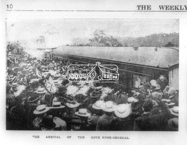
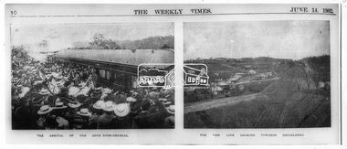
Photograph, Opening of the Railway Line; The arrival of the Governor-General, 6 June, 1902, 1902
Published: The opening of the railway line by His Excellency The Governor General, The Weekly Times, June 14, 1902, p10. Governor General was John Hope, Earl of Hopetoun THE HEIDELBERG TO ELTHAM RAILWAY. OPENING CEREMONY. The opening of the railway line from Heidelberg to Eltham took place on the 6th inst. The special train, containing a large number of members of Parliament, including Mr Trenwith, the Minister for Railways, left Prince's Bridge at half-past eleven, and arrived at Eltham at twenty minutes past twelve. The party was accompanied by Mr Fitzpatrick, Acting Commissioner for Railways; Mr Lockhead, the Traffic Manager; and Mr Norman, Engineer for Existing Lines. On arrival, the visitors were entertained at a banquet in the marquee, of which a photograph is given, erected close to the railway station. Mr E. H. Cameron, M.L.A., the member for the district, occupied the chair, and, seated on his right, was Mr Mason, the Speaker of the Legislative Assembly, and on his left the Minister of Rail-ways. After the banquet His Excellency the Governor-General arrived, and was received and welcomed by Mr Cameron, the local State school children singing the National Anthem. The Governor-General, in declaring the line open, said that he felt highly honored at being asked to perform the opening ceremony, and he trusted that the railway would be a source of great convenience to the inhabitants of the district. He was sorry to say that this would be the last opportunity he would have of seeing them. It cost him a great deal to leave them. (Hear, hear.) He had a great many friends amongst all sections of the community, and he could hardly bear to trust himself to speak about leaving them. (Hear, hear.) He was sorry Lady Hopetoun was on the high seas, and unable to accompany him that day. Mr Cameron thanked his Excellency for performing the opening ceremony, and hoped the trip home would have the effect of restoring His Excellency to good health again. In replying. Lord Hopetoun thanked them sincerely for the cordial vote of thanks. He hoped Providence would shower her blessings over them, and that they would have a series of good seasons. He would always keep a warm corner in his heart for the people of Victoria. (Loud cheers.) THE COUNTRY. In our illustrations, views are given of a couple of sections of the new line, and glimpses of the surrounding country are shown. The line is eight miles in length, and cost £51,000 in construction. Eltham, which is the terminus, possesses many of the features that go to make a favorite holiday resort. It is a quiet picturesque little hamlet, snugly ensconced on the slope of one of many sombre-tinted hills by which it is sur-rounded. Even when viewed under ad-verse conditions one could not fail to be-impressed with the natural, rugged beauty of the place. It is situated about sixteen miles from Melbourne, and the line takes a circuitous course through a continuation of pretty undulating country. At intervals on the slopes of the surrounding green-mantled hills, patches of brown, freshly tilled soil indicate that for all its serene reposeful-ness Eltham possesses its phases of industrial life as well. Looking down into this valley from the main road which skirts the slope of a hill, distant something less than a quarter of a mile from the railway station is one of the prettiest pieces of scenery in the district. Verdure-clad hills ascend on all sides, whilst beneath stretches a broad expanse of carpet-like green sward, dotted here and there with picturesque homesteads, each with its patches of tilled soil. In the township itself the dwelling-houses are comparatively few, the larger portion of the inhabitants residing in the scattered homesteads. Eltham is as yet only in its youth, but energetic and un-tiring public men can effect wonders in a community's prosperity, and Eltham, whatever other real or imaginary advantages it may lay claim to, certainly possesses this one. The railway is the result of their endeavor. 1902 'THE HEIDELBERG TO ELTHAM RAILWAY.', Weekly Times (Melbourne, Vic. : 1869 - 1954), 14 June, p. 14. , viewed 26 Sep 2018, http://nla.gov.au/nla.news-article221230719This photo forms part of a collection of photographs gathered by the Shire of Eltham for their centenary project book,"Pioneers and Painters: 100 years of the Shire of Eltham" by Alan Marshall (1971). The collection of over 500 images is held in partnership between Eltham District Historical Society and Yarra Plenty Regional Library (Eltham Library) and is now formally known as the 'The Shire of Eltham Pioneers Photograph Collection.' It is significant in being the first community sourced collection representing the places and people of the Shire's first one hundred years.Digital image Negative black and white film 120 6x9 format 2 stripsAgfa APX 100sepp, shire of eltham pioneers photograph collection, eltham, heidelberg-eltham railway extension, earl of hopetoun, john hope, opening day, railway line construction -
 Flagstaff Hill Maritime Museum and Village
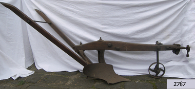
Tool - Plough, Syracuse Chilled Plow Co, 1876-1900
The Syracuse Chilled Plough Company was created in 1876 and specialised in the manufacture of agricultural ploughs. Harry Wiard invented the chilling process in plough manufacture. The company was originally founded as the Robinson Chilled Plough Company in 1876 and changed its name 3 years later. At its peak, in the early 20th century. The company made more than 100,000 horse-drawn ploughs and road scrapers of various designs that were sold from the Syracuse plant each year and exported around the world. The company slogan of the day was, “The sun never sets on a Syracuse plough." Eventually, other farming implements were added to the line. The company employed more than 300 people in its local plant, which covered a square block on the cities Near West Side. In 1910-11, Deere and Company began expanding its holdings, and with the success of the Syracuse Chilled Plough Company, Deere sought to acquire the company. The management of the Syracuse operation after John Deere took over remained in the hands of Wiard and Chase, and the manufacturing operations were left in Syracuse. The only change from previous Syracuse operations was the selling of the companies products through Deere retail outlets instead of directly to the trade. The factory in Syracuse continued to produce ploughs until 1955. The subject item in the Flagstaff collection is an early model Syracuse Chilled plough with a wooden beam frame it is very much lighter in weight and was adapted to work sandy or light loamy soil. This plough has a sloping landside, which tends to keep the clods and dirt from falling into the furrow, making the ploughman's work much more comfortable and easy. This design was made in eight sizes for both right and left-handed ploughing and became very popular in the far West and South of the USA. Note: The definition of a chill plough means : a plough having the share and mould-board of chilled semi steel or cast iron.The subject item is believed to be a very early plough given its wooden beam frame and was made before 1900 probably around 1880. This makes it a significant example of the types of plough that early settlers were using in Victoria. There would not be very many of this type of vintage plough left with a wooden beam and frame, making it today a desirable collector's item. Syracuse Wood Beam Chilled single furrow plough metal wheel in front. Syracuse Chiller Co Syracuse & 50 L stamped on ploughshare.flagstaff hill, warrnambool, shipwrecked-coast, flagstaff-hill, flagstaff-hill-maritime-museum, maritime-museum, shipwreck-coast, flagstaff-hill-maritime-village, plough, syracuse chiller co, chiller plourh, farm equipment, furrow -
 Eltham District Historical Society Inc
Document - Report, Tract Consultants Australia Pty Ltd, Eltham Cemetery: Towards a Master Plan, Nov 1987
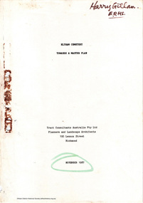
BACKGROUND The Eltham Cemetery is of historic significance to the Eltham area. The Trust was established in 1858 and has administered and maintained the cemetery from that date right up to the present. Among the more noteworthy graves is that of Sir William Irvine, a former State Premier and Chief Justice of Victoria. Eltham Cemetery is surrounded on three sides by urban development. Montsalvat Artists Colony adjoins the remaining (eastern) side. A Joint Select Committee of Parliament called the “Mortuary Industry and Cemeteries Administration Committee" (MICA) enquired into the land requirements at the Eltham Cemetery in 1986. The MICA recommendations contained in its 1986 report are included in the Appendices attached to this report. Although the recommendations have not been adopted by the Government it is interesting to note that the MICA report recommended the use of the bulk of the land for cemetery purpose. In June of 1987, the Cemetery Trust was expanded to include additional members from the Eltham Community by the Minister for Health. At the same time, he instructed the Trust to resolve the land requirement issues. As a result of this Ministerial direction, Tract Consultants has been instructed by the Eltham Cemetery Trust to prepare a report addressing the issues raised in the Minister's letter (see Appendix 1) to the Trust. Principally, the study will examine options available for development of the Cemetery. These options will explore possible boundaries, cemetery design, vegetation, the overall environment, landscaping and financial planning for the Cemetery operations. Appendix 2 details the Cemetery Trusts Terms of Reference for the Study. Before commencing the study in detail, additional basic information was sought; viz: a) sub-soil and rock analysis; and b) feature survey by a Licensed Surveyor. The results from both exercises are included as appendices to this report. Section three includes a summary of the findings along with other analytical results. Also: Eltham Cemetery - planning bewteen 1859 to 1860; research by Alan Sheehan April 2015, collated by Harry Gilham, EDHS, April 2016 (2 pages) PROV Guide 5: Cemetery Records (8 pages), printed 7 May 2014Development of Eltham Cemeteryeltham cemetery trust, master plan, mica, montsalvat, mortuary industry and cemeteries administration committee, tract consultants -
 City of Moorabbin Historical Society (Operating the Box Cottage Museum)
Document - Genealogy Chart Henry Dendy (Photocopy), 19 thC
In 1840 Henry Dendy, a farmer in Surrey, England acquired a "Special Survey" from the Commissioners for Land and Emigration which gave Dendy the right to choose land in Port Phillip for the "bargain basement" price of only £1 per acre for 5120 acres, (an area of 8 square miles). The Special Survey also included the right to "the shipment of a worker for every £20 spent on land, whose free passage was paid by the Crown, equalling a total of 100 workers ". Accordingly Dendy sold his English holdings and paid the required £5120 and arrived in Melbourne in February 1841. However by this time land in the new colony was selling for £5 - £40 per acre. Because Henry Dendy possessed the order from the Colonial Office in London he was able to successfully oppose Super-intendant LaTrobe's attempts to alter the price of the land. Dendy appointed Jonathan Were, (an entrepreneur, who had arrived in 1839), as his Manager and who later became a partner. Together, Dendy and Were decided on an area 5 miles south from Melbourne, bounded by North Road, East Boundary Road, South Road and to the west by Port Phillip Bay. Were and Dendy pitched their tents in the area now known as ' Park St, Brighton' and sank a well near the corner of 'St Andrew's St and Wells St'. By 1845 J.B Were and Company had bought almost half of Dendy's land and Were built himself "Moorabbin House" in Were St Brighton made from stone, quarried from local cliffs. It was still standing in 1924. Legend records Moorabbin is named after the Aboriginal word for ' Mother's Milk ' The soil is very fertile and well supplied with water especially in the area called 'East Brighton' - now known as Bentleigh and East Bentleigh - By 1850 the area had developed with numerous market gardens, dairy farms, fruit gardens and vineyards supplying food for the growing population of Melbourne.In 1840 Henry Dendy, a farmer in Surrey, England acquired a "Special Survey" from the Commissioners for Land and Emigration which gave Dendy the right to choose land in Port Phillip for the price of only £1 per acre for 5120 acres. This land was called Brighton in the Parish of Moorabbin, County of Bourke and emigrants developed the land establishing market gardens , dairy and poultry farms that provided the food for the growing population of Melbourne. A photocopy of the Genealogy Chart of the Dendy Family that Henry Dendy brought with him when he emigrated to Melbourne 1841Genealogy signs and descriptionsdendy henry, dendy's special survey brighton 1841, governor gipps, captain lonsdale, super-intendant latrobe, port phillip, melbourne, new south wales, squatters, emmigrants, county of bourke, parish of moorabbin, early settlers, pioneers, market gardeners, dairy farmers, fruit farms, moorabbin, bentleigh, brighton, cheltenham, were jonathan binn, -
City of Moorabbin Historical Society (Operating the Box Cottage Museum)
Document, Henry Dendy family Shield
In 1840 Henry Dendy, a farmer in Surrey, England acquired a "Special Survey" from the Commissioners for Land and Emigration which gave Dendy the right to choose land in Port Phillip for the "bargain basement" price of only £1 per acre for 5120 acres, (an area of 8 square miles). The Special Survey also included the right to "the shipment of a worker for every £20 spent on land, whose free passage was paid by the Crown, equalling a total of 100 workers ". Accordingly Dendy sold his English holdings and paid the required £5120 and arrived in Melbourne in February 1841. However by this time land in the new colony was selling for £5 - £40 per acre. Because Henry Dendy possessed the order from the Colonial Office in London he was able to successfully oppose Super-intendant LaTrobe's attempts to alter the price of the land. Dendy appointed Jonathan Were, (an entrepreneur, who had arrived in 1839), as his Manager and who later became a partner. Together, Dendy and Were decided on an area 5 miles south from Melbourne, bounded by North Road, East Boundary Road, South Road and to the west by Port Phillip Bay. Were and Dendy pitched their tents in the area now known as ' Park St, Brighton' and sank a well near the corner of 'St Andrew's St and Wells St'. By 1845 J.B Were and Company had bought almost half of Dendy's land and Were built himself "Moorabbin House" in Were St Brighton made from stone, quarried from local cliffs. It was still standing in 1924. Legend records Moorabbin is named after the Aboriginal word for ' Mother's Milk ' The soil is very fertile and well supplied with water especially in the area called 'East Brighton' - now known as Bentleigh and East Bentleigh - By 1850 the area had developed with numerous market gardens, dairy farms, fruit gardens and vineyards supplying food for the growing population of Melbourne. dendy henry, dendy's special survey brighton 1841, governor gipps, captain lonsdale, super-intendant latrobe, port phillip, melbourne, new south wales, squatters, emmigrants, county of bourke, parish of moorabbin, early settlers, pioneers, market gardeners, dairy farmers, fruit farms, moorabbin, bentleigh, brighton, cheltenham, were jonathan binn, -
 City of Moorabbin Historical Society (Operating the Box Cottage Museum)
Document - Pedigree of Henry Dendy, c1840 Original ; Copy 1985
This is a copy of the document brought by Henry Dendy to the Colony in 1841. In 1840 Henry Dendy, a farmer in Surrey, England acquired a "Special Survey" from the Commissioners for Land and Emigration which gave Dendy the right to choose land in Port Phillip for the "bargain basement" price of only £1 per acre for 5120 acres, (an area of 8 square miles). The Special Survey also included the right to "the shipment of a worker for every £20 spent on land, whose free passage was paid by the Crown, equalling a total of 100 workers ". Accordingly Dendy sold his English holdings and paid the required £5120 and arrived in Melbourne in February 1841. However by this time land in the new colony was selling for £5 - £40 per acre. Because Henry Dendy possessed the order from the Colonial Office in London he was able to successfully oppose Super-intendant LaTrobe's attempts to alter the price of the land. Dendy appointed Jonathan Were, (an entrepreneur, who had arrived in 1839), as his Manager and who later became a partner. Together, Dendy and Were decided on an area 5 miles south from Melbourne, bounded by North Road, East Boundary Road, South Road and to the west by Port Phillip Bay. Were and Dendy pitched their tents in the area now known as ' Park St, Brighton' and sank a well near the corner of 'St Andrew's St and Wells St'. By 1845 J.B Were and Company had bought almost half of Dendy's land and Were built himself "Moorabbin House" in Were St Brighton made from stone, quarried from local cliffs. It was still standing in 1924. Legend records Moorabbin is named after the Aboriginal word for ' Mother's Milk ' The soil is very fertile and well supplied with water especially in the area called 'East Brighton' - now known as Bentleigh and East Bentleigh - By 1850 the area had developed with numerous market gardens, dairy farms, fruit gardens and vineyards supplying food for the growing population of Melbourne. A copy of a paper chart of the Pedigree of Henry Dendy in a wooden frame with glassPedigree / of the branch of the family / DENDY moorabbin, brighton, henry dend special survey 1841 y, early settlers, pioneers, market gardeners -
 Eltham District Historical Society Inc
Photograph, St Andrews Primary School, Eltham Heritage Tour, 24 May 1992, 24/05/1992
ELTHAM HERITAGE TOUR The Society excursion on 24th May 1992 was arranged by David Bick, leader of the team carrying out the Shire's heritage study. David selected a number of sites or buildings identified in the study, some of them lesser known components of the Shire's heritage. The tour commenced at the Eltham Shire Office at 10.00 am. Travel was by private car and mini-bus with stops at about twelve locations for commentary by David.It included a short walk in Hurstbridge and lunch at Kinglake. Highlights of the tour included: - 10 am Leave from Shire Offices - 3 Important Trees - A Physical Link to Eltham's First Settlers - Toorak Mansion Gates - A Surviving Farm House - An Intact Circa 1900 Main Street - First Settlers - Gold Miners, and Timber-getters - An Early Hotel - A Pioneering Homestead - Changing Eltham Shire - 20th Century - 4 pm Afternoon Tea and Finish Tour Extract from ELTHAM CULTURAL HERITAGE TOUR (Newsletter No. 85, July 1992, by Bettina Woodburn) "At St Andrews we noted the old and new schools, the Anglican Church, the Hall, the Bakery and the pub – still a popular watering and eating place. Climbing towards Panton Hill the soil was not rich and supported only scarce growth. Perfunctory prospecting and mining had taken place in this area, though not with the diligence applied at Research. Again we saw the ingredients of a settlement, this one organised by Government, the Hotel, the Store, the School. Down from Memorial Park the School grounds had original tree planting and the School Bell dedicated to Maud Rattray who died in 1922. There is a new Hall and opposite in the grounds of the Church and Sunday School a modest Memorial Cross of granite with inscriptions and in memory of four 'fallen comrades'. This small section of the main road retained the small village atmosphere; although the population had increased there had been little alteration."Record of the Society's history and activities and highlighting various aspects of the Heritage Study undertaken by David Bick used to create the future heritage overlay for the Shire of Eltham and later Nillumbik Shire.Roll of 35mm colour negative film, 4 stripsKodak Gold 100 5095shire of eltham historical society, activities, heritage tour, st andrews -
 University of Melbourne, Burnley Campus Archives
Album - Black and white prints and negatives, James Leslie Provan, Photograph Collection, 1940-1950
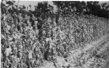
Collection of 39 black and white photographs. Some photographs with handwritten annotations in what looks like the handwriting of J.L. Provan. Mostly at Burnley, some at Moorabbin. (1) "Opium Poppy 1942 Burnley. Publicity Branch Department of Agriculture." Negative in envelope marked, "Prints 1 of No. 398 Department of Agriculture 'McP.' " (2) Grape vine and cabbages. (3) Rows of seedlings in the Orchard. (4) Orange tree? unpruned. (5) Flowers. (6) "Double and single rows of French Beans." (7) "Sage & marjoram." (8) Hydrangeas. (9)Sprinkler on newly planted cabbages. (10a)"Lettuce Iceberg 1/1/43." Seeds on soil surface. (10b) "Lettuce Iceberg 1/1/43." Seedlings emerging. (11)? planted in terracotta pipes. (12) Rows of seedlings in the Orchard. (13) "A student sowing Parsnip seed in a drill row. School of Horticulture Burnley Gardens." (14) Student distributing fertilizer? (15) Similar. (16) Similar. (17a) Flowers. (17b) Flowers. (18)"Beetroot Crimson Globe." (19) A seed drill. (20)Canna. (21a) Vegetable rows. (21b) ? (22) Student hoeing. (23) Student hoeing. (24) Similar. (26) "Cabbage Burbees Allhead 2/2/43," seedlings. (27) Water, manure, etc. (28) "Celery beds Ray Marriott Moorabbin April 2nd 1943." (29-37) Also at Moorabbin probably: (29) Vegetables. (30) Onions. (31) Vegetables. (32) Planting seedlings. (33) Vegetables. (34) Celery, carrots, turnips on display. (35) Carrots growing and just pulled up. (36) Peas. (37) Ploughing with horse. (38) Student spraying vegetables at Burnley. (39) House?j.l. provan, burnley, moorabbin, opium poppy, grape vine, cabbages, seedlings, orchards, orange trees, flowers, french beans, sage, marjoram, hydrangea, sprinkler, lettuce iceberg, seeds, students sowing, parsnips, school of horticulture burnley gardens, beetroot, hoeing, water, manure, celery, vegetables beds, ray marriott, onions, carrots, turnips, peas, ploughing, horse, spraying -
 Eltham District Historical Society Inc
Photograph, The Weekly Times, Opening of the Heidelberg-Eltham Railway Line, 6 June 1902, 1902
Reproduced from "The Weekly Times", 14th June 1902, page 10. 06 Jun 1902 Cross Reference Photo No.(s): 602, 604 Source: La Trobe Library and National Library, Canberra THE HEIDELBERG TO ELTHAM RAILWAY. OPENING CEREMONY. The opening of the railway line from Heidelberg to Eltham took place on the 6th inst. The special train, containing a large number of members of Parliament, including Mr Trenwith, the Minister for Railways, left Prince's Bridge at half-past eleven, and arrived at Eltham at twenty minutes past twelve. The party was accompanied by Mr Fitzpatrick, Acting Commissioner for Railways; Mr Lockhead, the Traffic Manager; and Mr Norman, Engineer for Existing Lines. On arrival, the visitors were entertained at a banquet in the marquee, of which a photograph is given, erected close to the railway station. Mr E. H. Cameron, M.L.A., the member for the district, occupied the chair, and, seated on his right, was Mr Mason, the Speaker of the Legislative Assembly, and on his left the Minister of Rail-ways. After the banquet His Excellency the Governor-General arrived, and was received and welcomed by Mr Cameron, the local State school children singing the National Anthem. The Governor-General, in declaring the line open, said that he felt highly honored at being asked to perform the opening ceremony, and he trusted that the railway would be a source of great convenience to the inhabitants of the district. He was sorry to say that this would be the last opportunity he would have of seeing them. It cost him a great deal to leave them. (Hear, hear.) He had a great many friends amongst all sections of the community, and he could hardly bear to trust himself to speak about leaving them. (Hear, hear.) He was sorry Lady Hopetoun was on the high seas, and unable to accompany him that day. Mr Cameron thanked his Excellency for performing the opening ceremony, and hoped the trip home would have the effect of restoring His Excellency to good health again. In replying. Lord Hopetoun thanked them sincerely for the cordial vote of thanks. He hoped Providence would shower her blessings over them, and that they would have a series of good seasons. He would always keep a warm corner in his heart for the people of Victoria. (Loud cheers.) THE COUNTRY. In our illustrations, views are given of a couple of sections of the new line, and glimpses of the surrounding country are shown. The line is eight miles in length, and cost £51,000 in construction. Eltham, which is the terminus, possesses many of the features that go to make a favorite holiday resort. It is a quiet picturesque little hamlet, snugly ensconced on the slope of one of many sombre-tinted hills by which it is sur-rounded. Even when viewed under ad-verse conditions one could not fail to be-impressed with the natural, rugged beauty of the place. It is situated about sixteen miles from Melbourne, and the line takes a circuitous course through a continuation of pretty undulating country. At intervals on the slopes of the surrounding green-mantled hills, patches of brown, freshly tilled soil indicate that for all its serene reposeful-ness Eltham possesses its phases of industrial life as well. Looking down into this valley from the main road which skirts the slope of a hill, distant something less than a quarter of a mile from the railway station is one of the prettiest pieces of scenery in the district. Verdure-clad hills ascend on all sides, whilst beneath stretches a broad expanse of carpet-like green sward, dotted here and there with picturesque homesteads, each with its patches of tilled soil. In the township itself the dwelling-houses are comparatively few, the larger portion of the inhabitants residing in the scattered homesteads. Eltham is as yet only in its youth, but energetic and un-tiring public men can effect wonders in a community's prosperity, and Eltham, whatever other real or imaginary advantages it may lay claim to, certainly possesses this one. The railway is the result of their endeavor. 1902 'THE HEIDELBERG TO ELTHAM RAILWAY.', Weekly Times (Melbourne, Vic. : 1869 - 1954), 14 June, p. 14. , viewed 26 Sep 2018, http://nla.gov.au/nla.news-article221230719This photo forms part of a collection of photographs gathered by the Shire of Eltham for their centenary project book,"Pioneers and Painters: 100 years of the Shire of Eltham" by Alan Marshall (1971). The collection of over 500 images is held in partnership between Eltham District Historical Society and Yarra Plenty Regional Library (Eltham Library) and is now formally known as the 'The Shire of Eltham Pioneers Photograph Collection.' It is significant in being the first community sourced collection representing the places and people of the Shire's first one hundred years.Digital image 35mm B&W negativesepp, shire of eltham pioneers photograph collection, eltham, heidelberg-eltham railway extension -
 The Beechworth Burke Museum
Photograph, 1920-1950
This image taken between 1920-1930 depicts open-cut hydraulic sluicing at the Three Mile Mine, located about five kilometres south of Beechworth. Alluvial, or surface, mining began on this site in the 1850s, but was soon replaced by hydraulic sluicing methods. By the start of 1880 it is estimated that nine hundred miles of water races had been cut though soil and rock in the Beechworth district. Hydraulic sluicing employs high pressure jets of water to blast away large areas of earth and wash it down to be run through a sluice box. Gold gets caught in the sluice and the remaining slurry is washed away. Large water quantities were required for hydraulic sluicing, and the long water races and deep tailraces that were constructed were considered great engineering feats. This method of mining is extremely effective, but causes significant environmental damage and impacts to waterways and agricultural operations. Miners at Beechworth built extensive networks of races and dams to secure reliable supplies of water on a scale far greater than elsewhere in Victoria. By the 1880s Beechworth's water barons continued to hold more than half of all the water right licences on issue and undertook sluicing operations on a massive scale. The manipulation of surface and ground water via race networks was well planned and recorded in detail by local mining surveyors. The maps that were created, combined with modern geo-spatial technologies, provide a vital key in understanding the great lengths to which miners went to capture and control critical water resources. Today, Three Mile mine is called Baarmutha. The Three Mile Mine was unproductive until 1865 when John Pund and three other miners secured a fifteen year license and constructed a water race from Upper Nine Mile Creek to Three Mile Creek. In the early twentieth century Pund & Co. averaged over one thousand ounces of gold per year from the mine. After Pund's death in 1915, GSG Amalgamated Co operated the site, continuing sluicing until 1950. This image of hydraulic sluicing methods shows the extent of water-works engineering in the landscape. This photograph has historic and research potential for understanding changes to the landscape, the evolution of mining methods, and the extensive construction, manipulation and management of water networks in the Beechworth district. Black and white rectangular photograph on matte paperReverse: 7597-1 / Sluice Mining / Copied from original on loan from Webb (Qld) / Donated Nov 2009 / Baarmutha Three Mile Mine c1920-1950 / Managed by the Plain Bros then Parkinsons / Current Location is: Beechworth Animal Shelter / used for Baarmuthaburke museum, beechworth museum, beechworth, gold fields, gold rush, victorian gold rush, hydraulic sluicing, spring creek, netwown falls, mining tunnels, water races, tailraces, gold ming history, colonial australia, australian gold rushes, mining technology, beechworth historic district, indigo gold trail, indigo shire, john pund, water manipulation, water engineering, three mile creek, three mile mine, water race, large-scale mining methods, historical mining construction, alluvial mining, mining environmental impacts, baarmutha, water barons -
 Mission to Seafarers Victoria
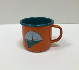
Souvenir - Cup, Margaret Woodward, 2015
Margaret Woodward is a an artist and an an associate professor of design at Charles Sturt University. Artist statement: "The Sea is All Around us is a multi-layered event which creates a memorable experience for those visiting the Dome Gallery and the Mission to Seafarers in Melbourne’s Docklands. The event acknowledges and raises awareness of the often difficult and dangerous working lives and journeys of seafarers by making visible their role in transporting commodities, materials and objects to and from Australia’s shores. This installation at the Dome Gallery in the Mission to Seafarers in Melbourne’s Docklands marks the third stage of an ongoing research project which seeks to reveal the ‘social life’ of souvenirs. Beyond their representational role souvenirs also trigger intangible, affective qualities – reminders of journeys and places, new associations with tastes, sounds and people, and thereby becoming objects which focus and hold memories. This installation invites seafarers and visitors to participate in a global project which aims to witness sea journeys and trace the mobile life of seafarers and souvenirs. For a fortnight in May 2015, the Dome Gallery became an architectural large scale compass, with the circular floor marking the intersection of its latitude and longitude (37 º 49'21" S 144º 57'03"E). Over these two weeks the Dome Gallery was inscribed with marks recording journeys made by seafarers, recording destination and departure ports, home lands and waterways, and in doing so making visible a small segment of the global patterns of seafaring. Custom-made souvenirs designed for the installation are given to seafarers as gestures of welcome and a memento of their visit. The souvenirs originating in Poland continue their journey by sea, to destinations beyond the Dome becoming part of the global network of seafaring, with an invitation for seafarers to record their future journeys using QR code scanning technologies. It is hoped that by releasing the 200 limited edition souvenirs accompanying the seafarers the mobile life of souvenirs and seafarers will also become visible. Like messages in bottles they leave our shores, becoming ambassadors, representing the Dome Gallery at the Mission to Seafarers, the waters of Port Phillip Bay, Australia’s red soil and vegetation, and carrying memories of visiting Melbourne." The Mission has always been open to the community and has a tradition of hosting cultural events: shows, concerts, exhibitions, festivals.Orange enamel and teal mug created for the art installation by artist Margaret Woodward at the Mission to Seafarers. On one side it is decorated with a compass and a latitude and longitude; on the opposite side, a leaf, a QR code on the bottom takes you to the website.Written at the bottom of the mug: Please scan to map the journey of this souvenir * www.sensingtheremote.net *2015cultural events, norla dome, mso, 2015, art installation, margaret woodward -
 Mission to Seafarers Victoria
Booklet - Catalogue, Margaret Woodward, The Sea is All Around us, 2015
Margaret Woodward is a an artist and an an associate professor of design at Charles Sturt University. Artist statement: "The Sea is All Around us is a multi-layered event which creates a memorable experience for those visiting the Dome Gallery and the Mission to Seafarers in Melbourne’s Docklands. The event acknowledges and raises awareness of the often difficult and dangerous working lives and journeys of seafarers by making visible their role in transporting commodities, materials and objects to and from Australia’s shores. This installation at the Dome Gallery in the Mission to Seafarers in Melbourne’s Docklands marks the third stage of an ongoing research project which seeks to reveal the ‘social life’ of souvenirs. Beyond their representational role souvenirs also trigger intangible, affective qualities – reminders of journeys and places, new associations with tastes, sounds and people, and thereby becoming objects which focus and hold memories. This installation invites seafarers and visitors to participate in a global project which aims to witness sea journeys and trace the mobile life of seafarers and souvenirs. For a fortnight in May 2015, the Dome Gallery became an architectural large scale compass, with the circular floor marking the intersection of its latitude and longitude (37 º 49'21" S 144º 57'03"E). Over these two weeks the Dome Gallery was inscribed with marks recording journeys made by seafarers, recording destination and departure ports, home lands and waterways, and in doing so making visible a small segment of the global patterns of seafaring. Custom-made souvenirs designed for the installation are given to seafarers as gestures of welcome and a memento of their visit. The souvenirs originating in Poland continue their journey by sea, to destinations beyond the Dome becoming part of the global network of seafaring, with an invitation for seafarers to record their future journeys using QR code scanning technologies. It is hoped that by releasing the 200 limited edition souvenirs accompanying the seafarers the mobile life of souvenirs and seafarers will also become visible. Like messages in bottles they leave our shores, becoming ambassadors, representing the Dome Gallery at the Mission to Seafarers, the waters of Port Phillip Bay, Australia’s red soil and vegetation, and carrying memories of visiting Melbourne." The Mission has always been open to the community and has a tradition of hosting cultural events: shows, concerts, exhibitions, festivals.Small flyer in PDf for the art installation by artist Margaret Woodward at the Mission to Seafarerscultural events, norla dome, mso, 2015, art installation, margaret woodward -
 Eltham District Historical Society Inc
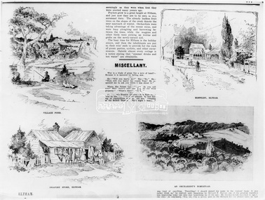
Photograph, The Australasian, Eltham - A series of four scenes of the local district, 2 May 1903
Australasian (Melbourne, Vic. : 1864 - 1946), Saturday 2 May 1903, page 25 ________________________________________ ELTHAM A POPULAR HOLIDAY SPOT. By L.J.J. The village of Eltham, with its 377 in habitants, is prettily situated on Diamond Creek, a tributary of the Yarra, 16 miles from Melbourne. Yet, in spite of it being so easily accessible from town, few people are aware of the beauties of this early settlement. Prior to June last year one had to journey by coach from Heidelberg to Eltham, but now the railway conveys passengers through from Melbourne to Eltham, first-class return, for 1/9. The opening of this extension to Eltham was the last ceremony performed by Lord Hopetoun, on June 5, 1902, prior to his departure from Australia. Sauntering through the township one autumn morning recently I was constantly reminded of scenes characteristic of Surrey or Sussex villages. There is the village pond (so essentially English), reflecting in its clear water a quaint cottage, dwarfed by a huge gum tree, an old smithy, and a hostelry, built quite fifty years ago, the flooring-boards of which the landlord informed me with pride were of Singapore cedar, and quite fit for another fifty years' wear. Then there are the village school, the shoemaker's, the drapery store, and the butcher's shop, all seemingly as they were when first they were erected many years ago. Poplars grow to a great height at Eltham, and just now they are to be seen in rich autumnal tints. The already leafless fruit trees on the slopes of the creek denote the near approach of winter. Orchardists were taking advantage of the recent rains, and were busy ploughing and harrowing between the trees, while the magpies and other birds were picking up worms and grubs on the newly-turned soil. The busy time for Eltham is the holiday season, and then the inhabitants are put to their wits' ends to provide for the rush of picnic parties, cyclists, and other excursionists. Outside almost every cottage is a notice stating that "summer drinks and hot water" are obtainable. Sketches illustrating the article: VILLAGE POND. DRAPERY STORE, ELTHAM. ON DIAMOND CREEK. HOSTELRY, ELTHAM. AN ORCHADIST'S HOMESTEAD. ON THE HEIDELBERG-ROAD IN AND AROUND ELTHAM.This photo forms part of a collection of photographs gathered by the Shire of Eltham for their centenary project book,"Pioneers and Painters: 100 years of the Shire of Eltham" by Alan Marshall (1971). The collection of over 500 images is held in partnership between Eltham District Historical Society and Yarra Plenty Regional Library (Eltham Library) and is now formally known as the 'The Shire of Eltham Pioneers Photograph Collection.' It is significant in being the first community sourced collection representing the places and people of the Shire's first one hundred years.Digital image Print B&W 20 x 25 cmsepp, shire of eltham pioneers photograph collection, drapery store, hostelery, orchardist's homestead, village pond, eltham, dalton street, evelyn hotel, hostelry, jarrold cottage, john street, main road, maria street, white cloud cottage -
 Flagstaff Hill Maritime Museum and Village
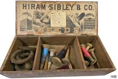
Container - Box for seeds, ca. 1880s
This seed box was made for Hiram Sibley for his seed house business. He sold seeds priced by the weight or the space they took up e.g. bushel. This box allowed for seeds to be divided by type, size or even date. The box was strong and easy to cart and store. It was also a handy item to 'recycle' as a storage container for other items. The Sibley seed box is a desirable collectors' item. A large variety of sizes and shapes are still available today in various stages of condition. Hiram Sibley developed seeds that were strong and the plants that grew from these seeds produced many seeds. Varieties of Sibley seeds and plants are still advertised for sale in modern times. HIRAM SIBLEY (1807-1888) - Hiram Sibley was born in America. He had a natural mechanical ability and became skilled in many trades. He and his partner Don Watson opened a sawmill then a machine shop and foundry. He became involved with Alfred Vale and Samuel Morse and their work on the telegraph. Eventually he became the first president of the Western Union Telegraph Company. Later, after leaving Western Union in the early 1860s, Sibley bought and sold railroads, manufactured sold, ran timber mills, and became involved in farming and seed supply. In this area he used his skills to engineer seeds that were stronger and develop plants that produced more seeds. The production of seeds became his main business. He bought land cheaply and improved to soil so that he could produce seed and grain, and graze herds of cattle. He became the owner of 14 large farms. Hiram Sibley earned the reputation "as the most extensive farmer and seedsman in this country". The business of Hiram Sibley & Co. was conducted his warehouse in Rochester and his seed house in Chicago. One department of the business sold farming equipment, another department imported ornamental plants from overseas countries Sibley went on to invest a large amount of money in a bank, and to be financially involved in the community by making large donations to public services such as a library and a school of music. At one point he was the richest man in Monroe county.This box is significant for its historic connection with Hiram Sibley, who is famous for many reasons, among which is his very profitable business of seed engineering to improve the production of crops. This box also represents the value of containers used for selling products in the 1880s, being re-used for other useful purposes. The box is an example of goods imported for use in Australia. The text and images of the box are an example of 1880s advertisingBox, wooden, with two brass hinges joining lid to base. Base has two wooden partitions, divided into three unequal sized compartments. Lid's underside has label with drawings of buildings and produce, text with maker's name and description of vegetables. Front edge of box has stencilled text and diagrams. Outside lid, and the other three sides, have no inscriptions. Made by Hiram Sibley & Co., USA. (Box is currently used to store quoits 1436.2 and cones of cotton thread 1436.3.)Marked "HIRAM SIBLEY & CO / SEEDS", "WAREHOUSE - "ROCHESTER N.Y. ", "SEED HOUSE - CHICARGO, ILL.", "SEEDS BY WEIGHT & MEASURE", "PUT UP BY / HIRAM SIBLEY & CO. / ROCHESTER, N.Y. AND CHICARGO, ILL."flagstaff hill, warrnambool, maritime village, maritime museum, flagstaff hill maritime museum & village, hiram sibley & co, rochester n.y., seeds, wooden seed box, seed box, seedsmen, arable farming, chicargo illinois, seed house, seed engineering, seed distribution, seeds by weight and measure -
 City of Moorabbin Historical Society (Operating the Box Cottage Museum)
Photograph - Map of Dendy's Special Survey, 1852 Map of Henry Dendy's Special Survey of 1841, 19th Century
A Map drawn in 1852 that shows the 5,120 acres that formed Dendy's Special Survey of 1841. In 1840 Henry Dendy, a farmer in Surrey, England acquired a "Special Survey" from the Commissioners for Land and Emigration which gave Dendy the right to choose land in Port Phillip for the "bargain basement" price of only £1 per acre for 5120 acres, (an area of 8 square miles). The Special Survey also included the right to "the shipment of a worker for every £20 spent on land, whose free passage was paid by the Crown, equalling a total of 100 workers ". Accordingly Dendy sold his English holdings and paid the required £5120 and arrived in Melbourne in February 1841. However by this time land in the new colony was selling for £5 - £40 per acre. Because Henry Dendy possessed the order from the Colonial Office in London he was able to successfully oppose Governor LaTrobe's attempts to alter the price of the land. Dendy appointed Jonathan Were, (an entrepreneur, who had arrived in 1839), as his Manager and who later became a partner. Together, Dendy and Were decided on an area 5 miles south from Melbourne, bounded by North Road, East Boundary Road, South Road and to the west by Port Phillip Bay. Were and Dendy pitched their tents in the area now known as ' Park St, Brighton' and sank a well near the corner of 'St Andrew's St and Wells St'. By 1845 J.B Were and Company had bought almost half of Dendy's land and Were built himself "Moorabbin House" in Were St Brighton made from stone, quarried from local cliffs. It was still standing in 1924. Legend records Moorabbin is named after the Aboriginal word for ' Mother's Milk ' The soil is very fertile and well supplied with water especially in the area called 'East Brighton' - now known as Bentleigh and East Bentleigh - By 1850 the area had developed with numerous market gardens, dairy farms, fruit gardens and vineyards supplying food for the growing population of Melbourne.This Map shows the birth of the Brighton and Moorabbin area. On 18th January1859 Brighton was proclaimed a Municipality and a Borough by October 1863. Meanwhile, following a Petition, the area of East and South Brighton, incorporating Mordialloc, Cheltenham, Mentone, Sandringham and Oakleigh separated from Brighton to form the Moorabbin District Roads Board becoming the first Local Government Authority. Col. William Mair was elected as the first Chairman of the Moorabbin Roads Board. Moorabbin Shire 1871 developed further and was declared a City in1934. The City of Moorabbin was the largest Municipality in Melbourne before the Amalgamation of Councils in 1994 when it was divided in the south to City of Kingston and in the north to City of Glen Eira A Photo-lithographed 1852 Map showing the 5,120 acres that formed Dendy's Special Survey of 1841. Henry Dendy & Jonathan Were chose an area 5 miles south from Melbourne, bounded by North Road, East Boundary Road, South Road and to the west by Port Phillip Bay. Moorabbin County of Bourke / Photo-Lithographed at the department of Lands and Survey. /Melbourne. / Price 1/- brighton, moorabbin, bentleigh, cheltenham, dendy henry, bent thomas, were jonathan, special survey -
 Eltham District Historical Society Inc
Photograph - Digital Photograph, Marguerite Marshall, Former home of Alistair and Margot Knox, King Street, Eltham, 16 January 2006
Situated in King Street, Eltham, Alistair Knox built his home and office in 1962-1963 with mud-bricks made from the local soil and recycled materials blending the house with bush around it. Knox popularised the Eltham earth building movement, begun by Montsalvat founder, Justus Jorgensen. Alistair Knox (1912-1986) was also an Eltham Shire Councillor 1971-1975 and Shire President in 1975. Knox established the inaugural Eltham Community Festival in 1975. Covered under Heritage Overlay, Nillumbik Planning Scheme. Published: Nillumbik Now and Then / Marguerite Marshall 2008; photographs Alan King with Marguerite Marshall.; p145 Lack of money was a strong incentive for Alistair Knox to do what he did best when he built his house and office at King Street, Eltham in 1962-63. He used mud-bricks from local soil and recycled materials, characteristically blending the house with the bush around it. The result was a work of art. Knox popularised the Eltham earth building movement,1 begun by Montsalvat founder Justus Jörgensen. He was also an Eltham Shire Councillor from 1971 to 1975 and Shire President in 1975. For Knox mud-brick building was not just a building style, but a spiritual experience and a way of relating with nature. At 40 he rediscovered God and his building reflected his theological, political, philosophical and particularly environmental world view, which was far ahead of its time.2 He also contributed to building development in his use of concrete slab foundations when stumps and bearers were the norm. Knox was introduced to mud-brick construction in 1940 by Jörgensen, then shortly after, Knox joined the Navy. In 1946 Knox studied Building Practice and Theory at Melbourne Technical College (now RMIT University). There he befriended fellow student and artist Matcham Skipper who belonged to what was then called the Jörgensen Artists’ Colony. Knox decided to build an earth building in Eltham, partly because the post-war huge building demands resulted in expensive and scarce building materials. He asked artist Sonia Skipper for help who, with Matcham, had constructed mud-brick buildings at the Artists’ Colony. The simple rectangular low-lying house at King Street is framed by native plants and a 3.6 metres wide pergola surrounds the building. Wedded to the landscape, a door in every room at the perimeter, opens outside. The property also includes a forge, a small hut built by son Macgregor at 15, and a mud-brick tower for chickens. Building materials were foraged from a wide variety of sources. Some of the joinery material came from old whisky vats. When the Oregon of the highest quality ‘was put through the wood-working machines, it gave off a deep smell of whisky that made the whole atmosphere exotic and heady’.3 Amateur builders, including schoolboys from Knox’s Presbyterian Church, made some of the mud-bricks. But the building was finished with the professional help of Yorkshire builder, Eric Hirst. Inside, the light is subdued with the mud-brick, beamed timber ceilings and floors of slate, timber or orange-brown tiles. Skylights, with rich blue and red leadlighting, illuminate one entrance area and this feature is repeated as edging on the door. The centre of the house is like a covered courtyard, with rooms built around it. The central room, 11 metres x 7 metres, was built in the same proportions as Knox’s mud-bricks. Clerestory windows on four sides infuse the room with a soft light. A huge brick fireplace extends beyond one corner and opposite is a small one where timber can only be placed vertically. The slate for the floor was discarded from the Malthouse Brewery now used as a theatre in Southbank. In the middle is a large refectory table and benches that seat 18. Like much of the house, it is rugged, yet beautiful. Made of Western Australian Jarrah by Macgregor with a chain saw and an adze, it retains knot and nail holes. Each wall has an opening, 2.4 metres at the ends and 3.6 metres at the sides. Only one has doors and these concertina doors are made of the backs of old church pews. The main bedroom has an ensuite with a marble hand basin discarded from the Victorian Parliament building; and a dressing room, where two wardrobes of polished timber recovered from a tip are attached to the walls. Separate from the house is the strikingly original circular-shaped office made of bluestone sourced from the original Army campsite at Broadmeadows.This collection of almost 130 photos about places and people within the Shire of Nillumbik, an urban and rural municipality in Melbourne's north, contributes to an understanding of the history of the Shire. Published in 2008 immediately prior to the Black Saturday bushfires of February 7, 2009, it documents sites that were impacted, and in some cases destroyed by the fires. It includes photographs taken especially for the publication, creating a unique time capsule representing the Shire in the early 21st century. It remains the most recent comprehenesive publication devoted to the Shire's history connecting local residents to the past. nillumbik now and then (marshall-king) collection, alistair and margot knox house, alistair knox design, mudbrick construction, eltham, king street -
 Federation University Historical Collection
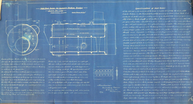
Plan, Mild Steel Boiler for Yarrawee Suction Dredge, 16 January 1907
George Milford, a long term staff member of Thompsons Foundry Castlemaine, remembers discussing Alexander Sinclair with this son, Alex Sinclair Jnr. "When Alex Jnr was a boy, his father, a senior design engineer, was sent to Malaya to oversee the erection on site of a suction cutter dredge for Thompsons. This was an adaptation of the idea of a bucket-dredge, where gold is won from alluvial gravels. In the 1915-1920 era, the Thompsons Engineering Department designed a suction-cutter dredge, by which hydraulic suction with a revolving cutter at the end of a long proboscis would collect the alluvial soil and deliver it into the dredge for recovery of the precious metals. Export marketing was then ‘all the go’, and the tin dredges were ordered from Thompsons, using the new cutter design. The dredges were, of course, shipped to Malaya in pieces, ready to be assembled on site. A number of Thompsons employees were selected to travel to Malaya to assemble the dredges. There were fourteen men in the gang. These men sailed on 1st July 1925, their number including Delmenico, McKay and Charles Albert Hauser, an engine driver. C A Hauser died of malaria in Malaya shortly after arrival. Components for a further three of these dredges were in transit or on site when the first suction-cutter dredge was assembled and tested. The designers had failed to take into account the fact that, in the jungle floor in Malaya, many trees grow up, and fall down, in tropical conditions, and become submerged still waterlogged in the floor of the jungle, and in the tin-bearing gravels. The suction-cutter dredge was found to be inefficient in these circumstances, the price of tin had fallen and the Malayan client reneged on the contract. Faced with an outlay of over £4,000 on which no money would be received, the company went bankrupt on 25th August 1925. Alex Sinclair Snr was at that stage in Malaya, and received the news of the bankruptcy by telegram. Upon telegraphing his employers for funds to return home, he received the reply that there were no such funds available. Alex Sinclair Jnr told the story of how his father worked as a labourer in Malaya for two years, while his mother took in washing and ironing during the same period, until together they had assembled enough money to pay for his father’s return Anyone who talks about “the good old days” is talking nonsense!"Large blue printed paper plan outlining the conditions of contract for the making of a steel boiler. The Blueprint includes design drawings and written contract specifying materials, time frame and costs. Signed on front 'Alec Sinclair Consulting Engineer, 31 Queen Street, Melbourne'. Stamped on verso 'Printed by Paterson & Co, Colonial Mutual Chambers, Collins St, Melbourne'. blueprint, designs and plans, yarrawee suction dredge, conditions of contract, thompsons foundry castlemaine, george milford -
 National Wool Museum
Textile - Diaper Set, Kathryn Knitwear, c.1960
Kathryn Knitwear, founded by Robert Blake, manufactured high quality children’s knitwear in Melbourne from the 1940s – 1980s. Robert Blake began manufacturing children’s knitwear in his bedroom in Strathmore using a hand powered machine in the late 1940s. The operation moved to Ascot Vale and Essendon, before eventually establishing a factory in Moonee Ponds in the early 1950s. The business continued to expand, necessitating a move to a new factory in Broadmeadows. By 1962, the Broadmeadows factory was producing an average of 20,000 garments per month, which increased to 24,000 by 1964. Robert Blake’s Son, Brendan recalls that “The Kathryn brand was famous around Australia, anywhere children needed to keep warm and dress smartly. It also won a number of wool fashion awards”, including the 1969 Wool Awards, which was held by the Australian Wool Bureau and published in Women’s Weekly. The Kathryn range was designed for durability, comfort and care, without sacrificing style. They used patterning techniques that increase stretchiness, comfort and fit, as well as integrating decorative elements into the fabric to prevent them from being bulky, uncomfortable or tight. Making longevity of style a priority, Brendan Blake remembers that “there was one particular garment that was in the range for at least thirty years”. He also recalls “In the past, when women have found out that I was associated with Kathryn Knitwear, they would often relate to me the story of a garment they had purchased or received as a gift and, when their child had grown out of it, they would hand it on to another child. Several ladies have told me of purchasing garments for their daughters’ glory box, or saving a particular garment after their daughter had grown out of it. Brendan Blake: “At the peak of their operation they employed approximately two hundred people, mainly women and girls. A family would often seek to send their daughter to work in this company because they knew they would be looked after and safe. One lady wrote to me telling me that working at the Moonee Ponds Factory prior to getting married was the happiest time of her life.” In 1963, workers at the Kathryn factory earned £13 per week, which was 8 shillings and 8 pence higher than the minimum weekly wage for female workers in the textile manufacturing industry (£12 11s 4d). By 1970, the Kathryn Knitwear brand expanded from children’s knitwear into womenswear under the brand name ‘Lady Kathryn’, and for boys and men under ‘Robert Blake’. Continuing to diversify their distribution, they also began exporting ‘Kathryn’ garments to New Zealand, the Pacific Islands, and Japan. ‘Kathryn Knitwear’ was well-known for their early adoption of modern materials and techniques that had broad appeal to their customer base. This is shown in their early use of the acrylic fibre ‘Orlon’ in the 50s and 60s and ‘Superwash’ wool in the 1970s. Many of Kathryn Knitwear’s styles, particularly those that were long running staples of the brand, were available in both wool and Orlon to suit the consumer’s preference. Cotton is a common material for knitwear worn in the warmer months, as it is very breathable and absorbs moisture easily. While we mostly associate knitwear with keeping us warm in the cold, the market for Australian knitwear would be very limited without options to wear all year round. The decoration on this garment was embroidered by hand by a skilled worker at the Kathryn Knitwear factory. Far from the humble origins of one man in his bedroom with a hand-cranked machine; at its closure in 1980, the Broadmeadows factory of ‘Kathryn’ housed more than 100 machines, including 53 sewing machines and 45 knitting machines. Robert Blake was “a passionate advocate for wool and Australian Made” throughout his whole life. A strong thread that ties through the lifespan of Robert Blake and Kathryn Knitwear is a balance between adopting new innovations without sacrificing the core values of durability, comfort, care and style that had made the brand so well known. Their legacy forms an integral part of both Australian social and manufacturing history.White diaper set. Short sleeved white top with two inverted box pleats along whole length, stitched at shoulder and mid chest. Embroidered in half cross stitch with two blue dogs on front. Closes in centre back with three plastic pearlescent buttons. White baby diaper shorts with ribbing at waist and leg holes .3 is a sample tag with manufacturing information, including price, size and colours available .4 is a swing tag with manufacturer care instructions.1 [label at back neck of top] Kathryn Reg’d / All Cotton / 18 .3 [sample label] [Obverse] STYLE: 314. Diaper Sat [sic] – Emb top. Combed Cotton. SIZE: 18” PRICE: 26/- COLOR: BLUE. LEMON. WHITE. [reverse] KATHRYN Garments are •PRE-SHRUNK •STANDARD MEASUREMENTS •FIT EXACTLY •LAUNDER PERFECTLY Designed and Manufactured by ROBERT BLAKE, MELBOURNE .4 [retail label] [obverse] Kathryn PRE-SHRUNK KNITWEAR Style: 314 [handwritten] DESIGNED & MANUFACTURED BY Robert Blake MELBOURNE [reverse] IMPORTANT. Special care should be taken with white and pastel shades. Rinse thoroughly. Do NOT dry in sunlight. WASHING INSTRUCTIONS 1.Wash frequently to AVOID HEAVY SOILING 2.Wash garment BY HAND, in lukewarm Velvet Soap suds. ON NO ACCOUNT RUB SOAP ON GARMENT. 3.Squeeze suds gently through garment but DO NOT RUB. Rubbing will cause garment to thicken. 4.RINSE AT LEAST TWICE IN CLEAN WATER TO REMOVE ALL SOAP. 5.To dry, roll garment in a towel to remove excess moisture, turn garment inside out and pull it lengthwise, then safety-pin to line through shoulder tape. 6.To keep Brushed Wool garments like new brush frequently with nylon brush.children's knitwear, children's clothing, knitwear, clothing, manufacturing, fashion textile production, embroidery, embroiderer, hand embroidery, dog embroidery, animal embroidery, animal motif, dog motif, dog, animal, baby clothes, baby knitwear, baby clothing -
 The Beechworth Burke Museum
Photograph, 1907-8
The photo from 1907-8 is a sepia print, depicting a small valley with building at base. There are flumes visible above areas of water, trees on hills and a few small cottages on the hillside. Cock's Pioneer Gold & Tin Sluicing Co NZ No 2 Site. The photo was taken of Matthews Gully looking west. Sluicing was undertaken in the area from 1900 to 1942 with some short breaks between these periods. The image depicts a location mined by Cocks Pioneer Gold and Tin Sluicing Company (as recorded on the annotation on the card mount) The Cocks Pioneer Gold and Tin Mines N.L was one of El Dorado's two largest open cut sluicing mines of the 20th Century. The other was named the Cocks El Dorado Gold Dredging Company. The Cocks Pioneer Mines operated from 1901 until 1941 and found a total of 117,378 ounces of Gold and 1,673 tones of tin concentrates over these years. The Cocks company was formed in 1898 and operated until 1941. Open cut sluicing involved the use of high-powered hoses which used the centrifugal sand pump system (known as hydraulic sluicing) which broke down the soil which was then processed for gold and other precious metals. From 1914 , four years after this image was captured, the company reformed to Cocks Pioneer Gold and Tin Mines NL (previously it was known as Cocks Pioneer Sluicing Co) and undertook large scale sluicing operations until 1929 and then 1934-1941. El Dorado is located on Reedy Creek and is surrounded by forested country to the north and east. It is 20 km east of Wangaratta in Victoria's regional north-east. John Cock was the son of a Cornish minor who arrived in El Dorado in 1858. Cock founded his gold and tin mining company which ran successfully for many years in the El Dorado region. It was an open cut sluicing company because of the abandonment of underground mining after this was deemed too dangerous. In 1935 Cock's El Dorado Company commissioned the floating dredge which is still visible in El Dorado today. The dredge was built by the Thompson engineering works, Castlemaine, and weighed over 2,000 tones and today has a place on the Victorian Registers of historic buildings. Interestingly, the name El Dorado does not derive from the gold in the region, but from the Barambogie pastoral run completed by William Baker in 1840-1841. Gold was discovered in El Dorado 1854 but the gold was too deep for individual prospectors to find, it required the use of heavy machinery.The search for gold is ingrained into the history of Victoria and therefore, images like this one which portray an open cut sluicing site can reveal important information for society and technology for the date when the photograph was taken. This image is of important historical significance for its ability to convey information about sluicing and the methods used to find gold in 1910. It also shows a location where sluicing was undertook which provides insight into the impact of sluicing on the environment at a time when it was done. This image is important for current research into the history of El Dorado, a small regional location near Wangaratta in Victoria's North East. Therefore, this image has the capacity to be beneficial for research into society and the motivations of those living and working in this region during this period and therefore, has social significance. The Beechworth Burke Museum has additional images relating to gold sluicing and El Dorado which can be analysed and studied alongside images like this one.Sepia coloured rectangle photograph printed on gloss photographic paper Reverse: 1997. 2613/ A02613/ No2 site/ Matthews Gully/ Cocks Pioneer G&T. ?? Co NZ/ No2 Site looking West/ 1907-8/ (7)sluicing, hydraulic sluicing, 1907, 1908, mining, cock's pioneer gold & tin sluicing co nz, nz, site no 2, matthews gully, west, valley, building, cottages, hillside, trees, water, gold and tin mine -
 Wodonga & District Historical Society Inc
Photograph - Falkiner Electric Road Train in front of George Leighton's Wodonga Store and Bakery Wodonga 1914
This image of the Ralph Falkiner’s Mueller Petrol-Electric Road Train was taken in Wodonga in February 1914. Imported from Germany by Mr Ralph S Falkiner in late 1913, the train’s inventor, Major W A Mueller with two assistants, came to Melbourne to assemble then commission the train. The train cost Mr Falkiner about £13,000 plus £4,591 import duties. The Falkiner family were sheep breeders in the Western Riverina and he hoped to use the road train primarily to convey wool to the railways for despatch to Sydney. The train was 216 feet long, weighed 43.5 tons with a top speed loaded of 6-8m/h and petrol consumption up to two gallons per mile. Its first Australian journey was to haul 50 tons of cargo to Edmondson & Co at Wagga Wagga, 277 miles away. The journey from Melbourne was plagued with problems including broken cylinders and crank shaft and overheating as it was not designed for Australian climatic conditions. Three months after leaving Melbourne it arrived in Wodonga. A series of problems between Springhurst and Wodonga, including broken cylinders and valves caused an eight day delay. Some of the cargo was off-loaded in Albury, then after repairs the train continued on to Wagga where it arrived in May 1914. After unloading there, the road train was taken to Mr Falkiner's Groongal Station, near Hay and subsequently made several long trips into drought-stricken areas or the Western Riverina. Eventually the dream collapsed when the engines gave out after the train bogged in the sticky black soil of the Hay plain with 251 bales of wool on board. The train was finally railed back to Melbourne and stored but destroyed when the warehouse burnt down. In this photo, the road train is drawn up outside the Wodonga Stores and Bakery owned and operated by George Leighton. Mr Leighton began his business opposite the Terminus Hotel in Sydney Street, Wodonga in 1885. His business included a general store, stocking groceries, ironmongery, drapery, crockeryware, boots and shoes as well as a bakery. He was very actively involved in the community and served on the Wodonga Council for 18 years including three terms as Wodonga Shire President in 1901 – 02, 1910-11 and 1913-14. He was also Chairman of the Wodonga Waterworks Trust for several terms. Mr. Leighton also took a prominent part in the movement to establish a Public Library in Wodonga. His other involvements including being a Founder of the Wodonga Lodge of Freemasons, Honorary Treasurer of the Wodonga Bulldogs Football Club and Secretary of the Wodonga Racing Club. Mr Leighton passed away in Wodonga in 1916.This image is significant because it records a rare event in Wodonga and an experiment in Australian road transport.Black and white images of the Falkiner Road Train in Wodonga and on its first journey from Melbourne to Wagga, NSW It is taken in front of the Wodonga Stores and Bakery operated by George Leighton in Sydney Street, Wodonga.falkiner electric train, early road transport, high street wodonga, george leighton -
 The Beechworth Burke Museum
Photograph
This image is a reproduction of an 1899 original depicting the 'Williams Good Luck Mine' on the Mopoke Reef (also called 'Morepork Gully') in the Dingle Ranges, approximately three miles from Beechworth. A large opening to a mine can be seen behind the men in the photograph, with a wheeled cart on a track leading to the men's position, where the soil and rocks have been hauled away. This photograph interestingly contains dogs alongside the miners. While dogs have been recorded as deterrents to thieves in the Victorian goldfields, these dogs appear as companions to these men. Following the discovery of gold at Beechworth in 1852, rushes quickly followed at surrounding creeks and gullies in the district. In the late nineteenth and early twentieth centuries, small syndicates of miners continued to work old or abandoned quartz reefs, often persisting without the assistance of heavy machinery to remove the large amounts of rock, in order to obtain yields at ever greater depths. The group of miners in this photograph are Mr. Roger Williams and Sons, who revived operations at the ‘Old Good Luck’ mine on the Mopoke Reef in the Dingle Range near Beechworth around 1892, working the site for more than two decades. An emigrant from Cornwall with experience in the tin mining industry, 19 year old Roger Williams senior sailed to New Zealand in 1840, then to Australia where he spent time in the Bendigo Gold Fields before settling in Beechworth in the early 1860s. Mr Williams senior worked on various mining activities in the district, including the Rocky Mountain Tunnel project. Conversant with the character of gold-bearing reefs in the area, the syndicate dug an eight hundred foot tunnel, digging down as far down as two hundred feet with little capital save their labour, to connect and provide better working access to the mass of reefs and veins in the vicinity. Progress was hampered by poor air quality charged with fumes from dynamite and large quantities of rock had to be crushed to obtain payable yields. The Victorian Goldfields are filled with ruins and remnants of the area's rich mining history, ranging from small alluvial diggings to the remains of huge mining companies. Site names often changed several times throughout the nineteenth and twentieth centuries. Some sites were abandoned and forgotten, others were worked continuously over many decades. The names of mines were often repeated at different locations throughout the Victorian Goldfields. For example, there is a Mopoke Gully heritage mine near Fryers Creek, Victoria. 'Mopoke' is a common onomatopoeic name for Morepork and Australian Boobook owls.This image has historical, social and research significance for patterns of emigration during of the Victorian Gold Rush, and the historical, social and environmental impacts of mining at Beechworth at the turn of the nineteenth and twentieth centuries. As gold became scarce and government support and large company investment waned, poor hard-working miners laboured intensively to make a living through periods of high unemployment. This image can be compared and studied alongside other historical mining photographs and objects in the Burke Museum Collection. It has potential to improve our understanding of miners working conditions and the shifting character of mining in the Beechworth district.Sepia coloured rectangular photograph printed on gloss photographic paper mounted on card. Obverse: Williams/ Good/ Luck Reverse: A02498/ 1997. 2498/ Good Luck/ Mine/ 1899/ Mopoke. burke museum, beechworth museum, beechworth, gold fields, gold rush, victorian gold rush, gold ming history, colonial australia, australian gold rushes, mining technology, beechworth historic district, indigo gold trail, migration, indigo shire, good luck gold mine, victorian goldfields, mining syndicates, gold fever, quartz-mining, small-scale mining, old good luck mine, mopoke gully, quartz reefs beechworth -
 The 5th/6th Battalion Royal Victoria Regiment Historical Collection
Print - Reproduction, framed, The Menin Gate at Midnight
'Menin Gate at midnight' was painted by Will Longstaff to commemorate those soldiers with no marked graves on the Western Front during the First World War; also known as 'Ghosts of Menin Gate'. Longstaff attended a ceremony dedicating the Menin Gate memorial to the soldiers of the British empire forces, just outside the town of Ypres, Belgium, on 24 July 1927. The memorial was dedicated to the 350,000 men of the British and Empire forces who had died in battles around Ypres, and bears the names of 55,000 men with no known grave, over 6,000 of whom were Australians. Longstaff was profoundly moved by what he witnessed and that night, unable to sleep, Longstaff returned to Menin Road and later claimed to have had a vision of spirits of the dead rising out of the soil around him. On returning to his studio in London he painted 'Menin Gate at midnight' in a single session. Today 'Menin Gate at midnight' has achieved the status of a national icon. The painting retains its ability to provoke an emotional response and to communicate the scale of the loss of life and the devastation of war. However as people now have a very different understanding of war, the painting serves a slightly different function. Whereas in the past people responded to the painting as it related to the loss of a loved one and their own personal grief, now the painting communicates the loss experienced by a whole generation. The vast number of those who were killed, and the immensity of the damage wrought during the First World War, requires that those who sacrificed their lives should not be forgotten. Longstaff used well-known motifs to trigger emotion. His scarlet poppies are flowers that could be found in the Flanders fields, but they also carry the traditional connotations of shed blood and remembrance; they represent a floral blanket covering the bloodied bodies of unknown soldiers; at the same time, like the paper poppies worn on Remembrance Day, they are a tribute from the living to the dead. The portrayal of the steel-helmeted soldiers rising from the cornfields extends the range of visual emblems used by Longstaff: the plentiful harvest; the harvest of men; the steel-helmeted crosses covering the graves of many soldiers; and the helmeted bayonets raised in cheer and victory.ww1, menin gate, wark vc club -
 University of Melbourne, Burnley Campus Archives
Photograph - Black and white and colour slides, colour negative, Kodachrome, Miscellaneous Horticulture, 1947-1985
57 slides and 1 negative. (3) Men standing around a large horticultural machine. (4) "Lawns Housing Com" Aug "66?" (5) "Flemington Racecourse." (6) "Mustard-Cover Crop. 1960." (7) Tree climbing. (8) "Grafting-scions. BHC." (11) "Mildura-Soil Probe Oct 67." (12) Virus tested stock trees & layout Flemings Apr 70." (13) "Best's Winery Mar 75." (15, 16) Best's single student and group. (17) "Ploughing-Diagram to show incomplete cover of trash? Farm Practices." (18) "Spraying Hand Equipment for Insect Control in and around Buildings USA Yearbook 1952." (19) "Pasture Harrows." (20) "Mould Board Plough-Tractor." (21) "Disc Harrows-Offset-Tractor." (22) Tyne Cultivator-for Tractor." (23) See B91.258." (24) Burnley College libary. (25) "Irrigation-Delver Tatura 12/59." (26) "Tatura 12/59 Delver Ferguson T." (27-29) "W. Prom." (30) Camp 1957 Wilson's Promontary." (34-36) Photographs of plants in book. (35) Alnus? (37) "Meterosideros excelsa." (38) "Rhipsalidopsis rosea." (39) "Protea neriifolia." (40) Banksias-Species." Insects: (41) "Lacewing larva." (42) "Mites Aug 75." (43) "Yellow Mite, Red Spider (Arachnida)." (44) "Jassid-Life Cycle 9/51." (45) "Grape Fruit Crop (Florida) Destroyed by Fruit Fly. Animals without backbones." (46) "Jassid-Vegetable 9/51." (47) "Field Day 57 (Fruit Fly-Enlarged)." (48) "Field Day 57 (Fruit Fly-Stages)." (49) Insect Life Cycle. (50) "Comatibility (sic) Chart." for Insecticides & Fungicides. (51) "Insecticides-Toxicity." (52) "Life Cycle of the Leather Jacket." (53) "Grasshopper-Head Dissected Mouth Parts." (54) "Types of Antennae." (55) "Spider Mites USA Yearbook 1952." (56) "Cultivator." (57) "Organic Phosphates." (58) Negative Isopogon anemonifolius.administration building, lawns, flemington racecourse, mustard-cover crop, tree climbing, grafting, mildura, soil probe, pests, machinery, excursions, tatura, library, wilsons promontory, plants, alnus, zygocactus, schlumbergia, feijoa, acca sellowiana, protea neriifolia, banksia, isopogon anemonifolius