Showing 15469 items
matching building society
-
 Kiewa Valley Historical Society
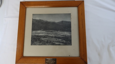
Photo - framed - Mt Beauty Central School
The school was built to educate the increasing number of children of the Kiewa Hydro Electric Scheme population. The school opened in 1948 in the Recreation hall and in the new building (photo) in 1950. A new wing was built in 1951 and became the Mt Beauty Higher Elementary School in 1953. By 1958 it had 617 pupils.Mr George Redfern was the Head Teacher for one year in 1951.Large black and white photo framed in thick wood and backed with cream cardboard. At the bottom on the wooden frame is a metal inscription.Inscription: Mt Beauty Central School / Presented to / Mr G. Redfern / as a token of esteem from / Mothers Club Committee / School Committee / 19.6.52mt beauty state school, kiewa hydro electric scheme -
 Kiewa Valley Historical Society
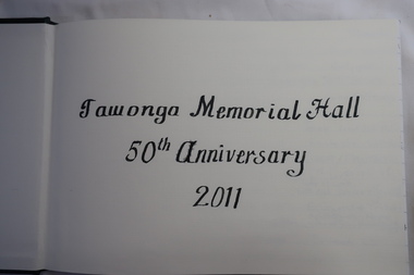
Book - Visitors to Tawonga, Tawonga Memorial Hall 50th Anniversary 2011
A celebration of the Tawonga hall's 50th anniversary was held at the hall on 15th January 2011. This is a record of those who attended and a reprt from the newspaper of the up-coming event.The district of Tawonga consists mostly of farmers and their families who socialised at the local hall on many occasions. The 50th anniversary of the building of the hall was therefore significant and a great reason for a reunion.Dark green leather bound visitor's book containing names of attendees of the Tawonga Hall 50th Anniversary Celebration in 2011. Enclosed is the newspaper report on the reunion to be held on the following day- Border Mail Friday January 14th 2011'Visitors' embossed on covertawonga hall, 50th anniversary -
 Kiewa Valley Historical Society
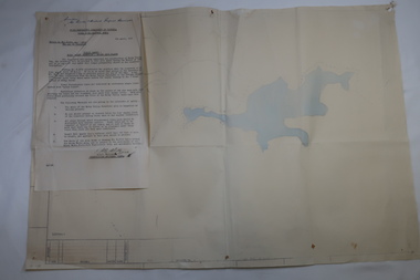
Plan Ref. K. 6612 with Letter attached re Public Safety in Kiewa Works Area
The SECV constructed the Kiewa Hydro Electric Scheme which included the building of Rocky Valley Dam on the Bogong High Plains near Falls Creek. H.H.C. Williams, construction engineer, Kiewa wrote to the Ski Clubs at Falls Creek outlining the dangers arising with the filling of Rocky Valley Dam. He lists 5 warnings in the interest of safety.The plan and letter provide the dates for the completion of Rocky Valley dam and its effect on the people living and working in the area including miners and ski clubs. It describes some of the features of Kiewa Works Area at the time.Plan No. K 6612 of Fall Creek showing Rocky Valley Dam's shape when it is full. Letter dated 6th April 1959 from H.H.C. Williams to Ski Clubs at Falls Creek re public safety as Rocky Valley fills. Refers to roads, transmission lines, pole lines etc in the Kiewa Works Area.Written in ink at top of letter - "Secretary / Mt Beauty and District Progress Association"rocky valley dam, falls creek ski clubs, h.h.c. williams, khes 1959, safety -
 Kiewa Valley Historical Society
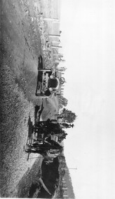
Photo: Making of Kiewa Valley Highway at Tawonga
The Kiewa Valley Highway was/is a major road along the Kiewa River ending at Mt Beauty the site of the S.E.C.V. town built for the construction of the K.H.E.S.Black and white photo with roofless old car beside two horses pulling a cart with man behind the cart. All coming towards the photographer on a road with paddocks on each side.kiewa valley highway, road building -
 Kiewa Valley Historical Society
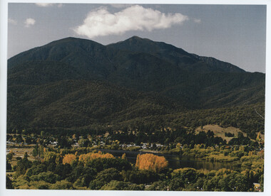
Photos - Mt Beauty Township and 'The Chalet'
Mt Beauty was built by the SECV to house the workers working on the Kiewa Hydro Electric Scheme.A. Colored photo of Mt Beauty Township in Autumn with Mount Bogong in the background. B. A long black and white photo attached to white cardboard with the title 'Staff accommodation Mt Beauty 1948-49' written below the photo.On the back in pencil 'Building "The Chalet" 1948-49'the chalet mt beauty -
 Kiewa Valley Historical Society
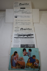
Newsletters - Mount Beauty Schools
Education in Mount Beauty began in the 1940s when the SECV constructed the town of Mount Beauty for their workers and staff. The educational facilities included a kindergarten, a primary / consolidated school and a secondary college. Mount Beauty education was highly valued by the residents of Mt Beauty and families in the Kiewa Valley. In the 1940s and 1950s it was very modern with new buildings and included the latest in teaching aids and technology. A Collection of Mount Beauty Primary School, Secondary College, Mt Beauty Kindergarten Newsletters Dates 1992 - 1997. Note: Photo includes hand made booklet with photos of children at schooleducation in mount beauty, mt beauty school newsletters -
 Kiewa Valley Historical Society
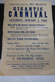
Poster - Mt Beauty Gigantic Carnival, 1960
The residents of Mt Beauty and the Kiewa Valley swam in the local East and West Kiewa Rivers. The community began planning the building of a swimming pool at Mt Beauty in the early 1960s and held events to raise money for it. The building of a swimming pool in Mt Beauty is part of the construction town's development and demonstrates the support of the community, especially the Mt Beauty and District Progress Association, and the SECV.Yellowed paper with black print dated Saturday, January 2, 1960 advertising the events for the day at Mt Beauty. Proceeds to the Swimming Pool.mt beauty swimming pool, carnival, mt beauty and district progress association -
 Kiewa Valley Historical Society
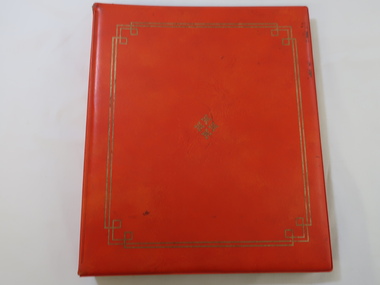
Photo Album - Senior Citizens' Clubrooms, Official Opening of the Senior Citizens' Clubrooms
The Mount Beauty Senior Citizens' Clubrooms were officially opened on the 8th December 1972.The building was built and owned by the (then) Bright Shire after much lobbying and fund raising by a local steering committee. It has served the community well for over 50 years.This album is a significant reminder of how the community of Mount Beauty was always pro-active in the development of community welfare and assets.Orange Vinyl covered photo album circa 1960s-1970s. Inside the covers are 10 double-sided plastic-covered cardboard pages secured by a metal spirex type page holder. Two gold lines with geometric cornice design border the cover. Four snowflake shapes form a diamond shape embossing in the centre of the cover also in gold. Manfacturer -Advance - Style 101220 inside back cover in gold.mt beauty senior citizens club -
 Kiewa Valley Historical Society
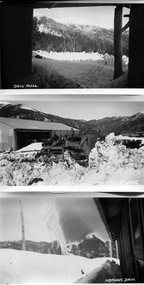
Photos - S.E.C. Work on Kiewa Hydro Electric Scheme
B & W photos - x2 of Homans and x1 of Sawmill with titles in white on the bottom left hand corner. And one other photo of a building in snowHowmans Dam; Howmans Gap; Saw Mill -
 Kiewa Valley Historical Society
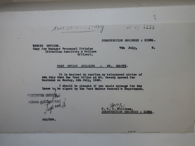
Papers - Mt Beauty Post Office Building
Mt Beauty was built by the SECV during the construction of the KHES. The Mt Beauty Post Office was opened on 4th July 1949The Mt Beauty Post Office is part of Mt Beauty's history. It is still located in the same place and now sells gifts for the tourists, stationary and clothing.Photocopy of letter re Post Office Building - Mt Beauty advising that the Post Office at My Beauty opened for business on Monday, 4th July, 1949. Also photocopies of 4 official SECV photos - 1. The Mt Beauty township Jan. 1948 2. Exterior of the New Post Office Mt Beauty dated July 1949 and 3. Interior of the New Post Office Mt Beauty dated July 1949mt beauty post office -
 Kiewa Valley Historical Society
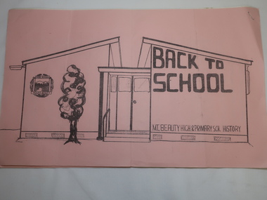
Papers - Mt Beauty High School No.4644, Back to School - Mt Beauty High and Primary School History. See also KVHS 0833
10 points of history pertaining to the History of Schooling in Mt Beauty from 1947 when the SECV and the Education Department erected the school as the population of Mt Beauty grew.A detailed account of the history of schooling at Mt Beauty. Mt Beauty was a construction town run by the SECV when building the KHES.Pink front cover followed by 5 pages of foolscap papers with staple in top right hand corner. Title in black print. In two parts - 1. State School No. 4644 Mount Beauty / Some (10) Points from the School History 2.Mount Beauty High Schoolmt beauty state school, school no. 4644, education -
 Kiewa Valley Historical Society
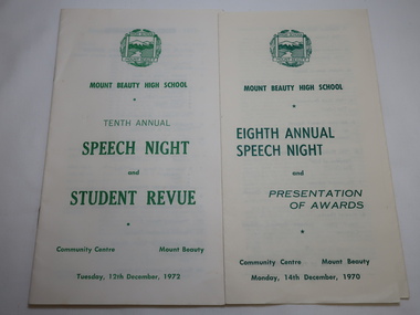
Mt Beauty High School Speech Night 1971 and 1972
Mount Beauty High School was proclaimed in 1963 with 213 pupils, 12 staff members. The enrolments and staff numbers increased as the Kiewa Hydro Electric Scheme continued to be constructed . 1. The Annual Report gives details re Accommodation, Grounds & Buildings, Equipment, Curriculum, Activities, Advisory Council, Cafeteria, Staff and Thanks. 2. In 1972, 27 teachers (names & subjects) are listed as well as other staff. The Reports are similar to that in 1970Mt Beauty High School grew quickly and then declined in numbers as the Kiewa Hydro Electric Scheme was constructed from the late 1940s to the 1960s. It is currently (2023) still operating serving the population in the Kiewa Valley. 1.Pale yellow paper folded x2 opening up to 3 columns of green print. 12 items listed followed by 'Extracts from the Eighth Annual Report. The Report contiues on the back. Front page has logo, title & date 14th Dec. 1970 2. Booklet of 12 pages (6 paper sheets)14 items on page 2, Staff listed on page 3, Principal's Report on page 4- 6. S.R.C. Report page 7, 10th Annual Report page 8-9,President's Report page 10. Scholarships & Awards page 11-12. Front page has logo and title. Tenth Annual Speech Night and Student Revue 12th December 1972 mt beauty high school, speech night programmes 1970 1972 -
 Kiewa Valley Historical Society
Brick - Hand-made Tawonga Brick Factory
Hand-made at the Tawonga Brick factoryMade at the Tawonga brick factory.Formerly KV 106 Rough surface of a hand made brick used for building eg. houseshand-made brick, tawonga brick factory -
 Kiewa Valley Historical Society
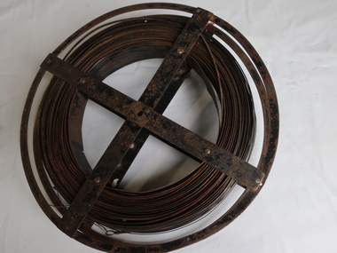
Surveyors Chain - Steel Band
A chain is a unit of length equal to 66 feet or 22 yards. This is a statute measure in the United Kingdom. One link is 100th part of a chain, which is 7.92 inches (20.1 cm). The chain and link became standard surveyors' units of length and crossed to the colonies from the United Kingdom. The chain is the unit of linear measurement for the survey of the public lands as prescribed by law. In Australia most building lots in the past were a quarter of an acre, measuring one chain by two and a half chains. Also street frontages, roads, laneways. The chain also survives as the length of a cricket pitch, being the distance between the stumps. Surveyors and residents of the Kiewa Valley used the Steel Band Surveyors Chain to measure distances when developing the land.Surveyors' steel band measuring tape, known as a 'standard band', or a 'steel band chain'.This chain consists of a long narrow strip of steel of uniform width of 3 mm and thickness of 0.3 to 0.6 mm. The chain itself is between 20 m and 30 m long.surveyors, surveyors chain, measurement of distance -
 Kiewa Valley Historical Society
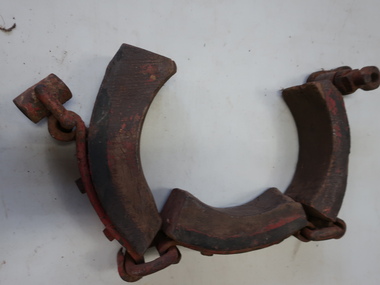
Dray Brake Band, Horse Equipment
Drays were used to transport heavy materials such as farm products, building supplies, food. They were pulled by horses or bullocks. Drays were important for transportation in the Kiewa Valley.Made of timber and steel. The piece of wood contacts the axle hub to brake the dray. Part of a brake for a dray. It is missing the actuator that is needed for tightening the band to operate as a brake.drays, horses, bullocks -
 Kiewa Valley Historical Society
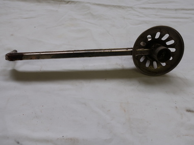
Candle Holder - Wall Bracket
This sconce - wall mounted candle holder or light fixture is simple / basic without any decoration. It was able to swivel. It may have been used on either the interior o exterior walls of buildings. The light is usually, but not always, directed upwards and outwards, rather than down. The long bracket kept the candle a safe distance from the wall and ceiling.This sconce was used by a resident of the Kiewa Valley.Shiny metal rod with candle holder at one end and a small thin rod at the other for attaching to a device on a wall. The candle holder is surrounded by a metal shallow 'cup' with 11 oval holes enabling the wax to fall to the centre where there is a hollow globe and allowing the light to shine upwards.sconce, candle holder, wall mounted candle holder -
 Kiewa Valley Historical Society
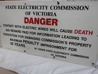
Sign - S.E.C.V
The SECV constructed the KHES and were required to put Safety signs in public and dangerous places.The SECV built the KHES and were responsible for safety signs for the publicLarge metal safety sign warning the public of Danger. Black print with "Danger" and "Death" printed in red. There are 10 holes for erecting the sign onto a eg. building. There is a hole in each corner and one in the centre of the two sides and two equally spaced between the corners of the top and bottom sides.secv safety sign -
 4th/19th Prince of Wales's Light Horse Regiment Unit History Room
Medal, Stokes and Sons, Honor to the AIF, Anzac Day 1918
This medal is an example of the type issued by the Victorian Education Department and sold on behalf of the Australian branch of the British Red Cross Society. It was made by Stokes and Sons, Melbourne, in a variety of metals including bronze, silvered bronze (as with this one), sliver, and gold. The mintage quantity is not known. and the initials HH refer to Harry Harvey, an art assistant at the EVD who designed the bust. 26mm dia bronze coloured medal on red,white & blue ribbon lGallipoli, France, Palestine, EVD, ANZAC DAY 1918 medal, honor to aif -
4th/19th Prince of Wales's Light Horse Regiment Unit History Room
Journal Article, J Williams, The Case of the Vanishing Regiment, 1985
An article from "Sabretache", the Journal of the Military Historical Society of Australia, about the 4th Light Horse Regiment in France and Belgium. In then published material about that area reference to the 4th was very light. The author corrects some of the errors and omissions and investigates the activities of the 4th between 1916 and 1918.Sabretache Vol XXVI - April/June 19854th light horse regiment, western front -
 Kiewa Valley Historical Society
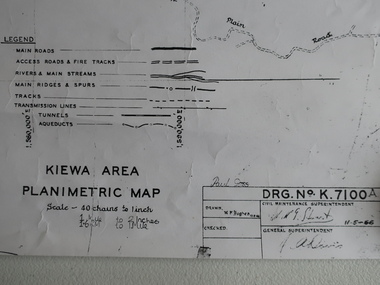
Map - Kiewa Area Planimetric Map
Planimetric maps are two-dimensional representations of the Earth's surface, showing the location and spatial arrangement of features such as roads, buildings, and bodies of water.A very clear map showing the Kiewa Hydro Electric Scheme in two dimensions to include the construction done by the SECV.Black and white Map of the Kiewa Area from Mt Beauty to the High Plains covering the Kiewa Hydro Electric Scheme and surrounds. Drawn on 11th May 1966kiewa hydro electric scheme 1966 -
 Kiewa Valley Historical Society
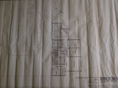
Plan - Shire of Bright - Mt Beauty Swimming Pool and Sporting Complex 1985 x2
Mt Beauty residents swam in the local rivers. The new complex was safer and included amenities eg. toilets, change room etc. It was easier to supervise and teach swimmers and to develop their skills in water.The swimming pool enabled residents and visitors of the Kiewa Valley to swim in safety and to improve their water skills.Two Black and White plans each showing the proposed buildings and pool areas of the Mt Beauty Swimming Pool and Sporting Complex. Dated 26th June 1985mt beauty swimming pool, shire of bright -
 Kiewa Valley Historical Society
Maps - Kiewa Valley Parish Maps x3 and Kiewa Area Planimetric Map x1
Planimetric maps are 2 dimensional representations of the Earth's surface, showing the location and spatial arrangement of features such as roads, buildings, and bodies of water. The parish maps show the occupiers with leases or licences of the land. These are updated by the Department of Lands regularly. The names of early settlers of the Kiewa Valley occupying land by lease or licence are shown. Many of these familie's descendants still live in the Kiewa Valley.1. Kiewa Area Planimetric Map (photo) 2. Wermatong, County of Bogong Parish Map 3. Mulllindolingong, County of Bogong Parish Map 4. Mullagong, County of Bogong Parish Map All black and white kiewa valley. parish maps. land owners -
 Raymond Island Historical Society
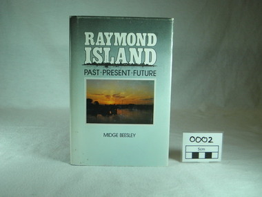
Book, Midge Beesley, Raymond Island:past present future, 1986
Local history of Raymond Island. Includes stories of Island identities, maps, photographsLocal significance Out of print publicationMonograph publication 291 pages Hardback Loose cover Maps Sunset picture of lake from Raymond Island on front cover Photographs of people, buildings, Raymond Island ferries, boats. Contents: Raymond Island early settlers, indigenous history, Island identities, Raymond Island State School, a'Beckett Park, Raymond Island Ferry, The Presbyterian Church, raymond Island Advancement League park, gippsland lakes, raymond island, raymond island state school, a beckett, raymond island ferry, early, settlers, raymond island advancement league -
 Kiewa Valley Historical Society
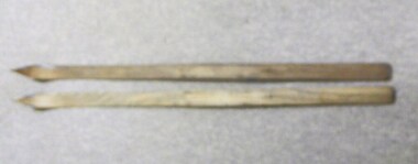
Skis, 1944-45
Skiing was first done at Falls Creek with the building of the towns of Bogong and Mt Beauty. European workers to the Hydro scheme thought that Falls Creek would make a good skiing village. The first ski lodge being opened in 1947. These skiis would have been used in those first seasons of Falls Creek and used by the first skiers of the time from 1945 onwards.These skiis are historically and socially significant, as they would have been one of the first type of skiis used at Falls Creek, one of Victoria first ski resorts, and used by the pioneers of skiing in Victoria. This item has good interpretive capacity as it shows the style of skiis that were used in the 1940's and they are a good comparative item against modern skiis. These skiis were used by Bill Bertram during the first winter traverse from Mount Hotham to the Mountain Creek base of Mount Bogong, see KVHS 0161 for biography of this historical event.Painted Red base with blue undercoat with center groove from base to 3/4 of way towards tip At tips are square pices with round holes possbily HOME MADE? 21 plus 2 holes on top face (for binding)sport, pioneers, snow, skiis, skiing, falls-creek, bogong-village, mt-beauty -
 Kiewa Valley Historical Society
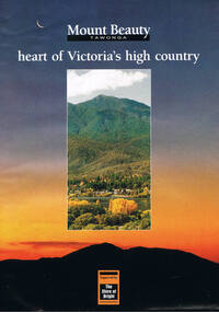
Poster Brochure, Mt Beauty Tawonga Heart Of Victoria's High Country, Circa 1995
The Item is a pictorial time piece of the valley and usage, farms,industry,town area, vegetation and winter snow levels Historical and the social-economical development at circa 1995 of land usage and residential buildings style.Major social events e.g. Festival of the Bogong Moth and the Mt Beauty Mardi Gras. It is also a good historical record of tourism campaigns of the Alpine Shire and Mt Beauty Chamber of Commerce. Also see "KVHS 0125"Brochure folds out from a 20.5cm x 29.5cm to 82cm x 29.5cm poster type documentinside panoramic photo of snow tipped alpine mountain range incorporating the Mount Beauty township, farming area of the Kiewa Valley and relevant tourist orientated informationtourism mt beauty tawonga photographs, victorian alps -
 Kiewa Valley Historical Society
Church Collection Receptacles, circa1900s
This church collection bag is quite unique in that it has three grip handles, not the usual two. Why three. It may represent the holy trinity of, the father,the son and the holy spirit. Historically this might be used to reinforce the holy trinity belief which at the time of this item's construction was under threat. The threat came from splinter Christian sects such as the Church Of Jesus Christ of the Latter-Day Saints which have a Godhead of a council of three deities and there are other christian religions of only one deity covering the father,the son and the holy spirit.This collection bag for offerings, was the main method available towards the upkeep of the church and its parish during this era. Broadcasting of religious services was not as prolific as in the late 1900s and into the 2000s. It was a time when visualisation of the support of religion(especially in rural ares) was an important social factor. The God "fearing" beliefs within society of this period, provided the strong moral fabric which permitted settlements that did not have a strong law enforcement section to prosper and develop without fear or "favour". The collection bag was, and is still, a physical endorsement of support towards the church and what it stands for. This was a time when it was a social requirement to be seen in the church building and supporting fellow parishioners. The ingrained Australian psyche of supporting anyone that needed help, was a result of this period.Church collection/donation bag. Simple construction of two round frames with three opposing handles nailed together to hold firm a small dark blue cloth pocket/bag. All fastened by nails to the handle/frame and the large pocket allows for a reasonable amount of coin or notes to be offered.religion, collection receptacles, christian offerings, church protocols -
 Kiewa Valley Historical Society
Photograph Junction Dam, Photo Junction Dam and Bogong Village in Background, circa 1950s
This item clearly shows the conditions covering both working conditions and housing in the construction of the Junction Dam in the 1940s. Working conditions were extreme and health and safety legislation was at its infancy. The residential buildings were intended to last only for the period of construction, however greater demand for longevity as a tourist haven prevailedThis photo of the construction of the Junction Dam, with The Bogong village as backdrop, details the harsh conditions faced by construction workers, building dams and villages to accommodate workers in the 1940s to the 1950s. Australia at this period in time, experienced a surge of population (influx of World War II refugees), which was the catalyst for developing and undergoing an enormous hydroelectricity program for the Alpine regions, both in Victoria and New South Wales. This program was initiated to supply electricity to the major southern Australian cities of Adelaide, Melbourne and Sydney. It was thought that these developments would reduce, if not eliminate, the requirement for coal driven power stations. However time has demonstrated that these power stations have not matched the demand required by the industries and the populations of the major urban and cities.Black and white photo of original photo with a flashlight reflection in the bottom centre. The photo is on Kodak XtraLife II paper. The paper is semi gloss.This photo is of the construction of the Junction Dam Wall with the Bogong Townshiip in the background.Back of photo is printed " Kodak XtraLite II paperdam construction, bogong village, alpine development, junction dam -
 Kiewa Valley Historical Society
Photograph of Kiewa Valley Panorama, Kiewa Valley from No. 5 Road, Before 1945
In 1943 a camp for workmen was erected and a commencement made with the erection of plant storage and workshop buildings in the new township of Mt. Beauty. The photograph was probably taken after the completion of these buildings. There is no sign of construction of the town itself. In the latter part of 1945 work was commenced on the Mt. Beauty township area with a medical centre, general trading store and some houses under construction. The No. 5 Road, from where the photograph was taken, is the road to West Kiewa Power Station and Big Hill Scenic Lookout.Is an excellent view of the Kiewa Valley before there was little work undertaken to establish the town of Mt. Beauty. Farming was well established with the evidence of huge areas of cleared land. The junction of the East and West Kiewa Rivers can be clearly seen. The first Workmen's camp is near the river and some workshop buildings can also be seen. Black and white photograph of the Kiewa Valley, looking North.Handwritten on the back of photograph "Kiewa Valley from No. 5 Road".kiewa valley, camp, buildings, mt. beauty -
 Kiewa Valley Historical Society
Mug Stoneware
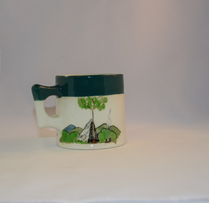
This ceramic mug is titled "Bill Bogong's Mug" in honour of one of Australia's Scouting (Rovers) notable office holders, Mr.W.F."Bill" Waters. He was born on 22nd August 1897 in Taralgon, Victoria, Australia and died 8th October 1968 in Fitzroy, Victoria. He was instrumental in the Rovers building two chalets in the Victorian Alps. The Victorian Award of the National Rover Service Award(1980) has been named after Bill Waters. Bill Waters was also the leader of the first team that climbed Mount Bogong in winter in 1929. Also was part of rescue team of what is now know as the Cleve Cole tragedy on Mt Bogong in the mid 1930's. There is also a water fall named after him Waters Falls on the Bogong High Plains. W.F."Bill" Waters aka "Bill Bogong" (Bogong mountain, were his ashes were scattered), was not only a prominent bush walker (Melbourne Walking Club) of the high country (Victorian Alps) but was instrumental in establishing two Chalets. One of these Chalets was the first one to be built on the Bogong High Plains. This item, "Bill Bogong's Mug" is what the Flinders Petrie(famous English Egyptologist/Archaelogist) Rover Crew(formed in 1940) presented newly invested members of the exclusive(200 membership) Alpine Rover Crew. The Melbourne Walking Club has a long history with the Victorian High Plains area, of which the Kiewa Valley is an integral part of the Victorian Alpine Region. Due to the connections Bill Waters has with the Bogong High Plains and Mt Bogong this cup has a lot of significance to the social history of the area.. Round glazed stoneware mug, white in colour, with a heritage green coloured band covering the top rim and handle. Written inscription on the front "Bill Bogong's Mug" in large print and beneath it, in smaller print, "with compliments from Flinders Petrie Rover Crew" The other side of the mug is a free hand landscaped drawing of green bush and blue hills with a tree supporting a tent and a camp fire (with smoke rising from it).To the left of the inscription is the Scout (Rover) emblem coloured black with an unraveled and unwritten signage scroll fowler ceramics, local alpine history, alpine rovers, scouts, mugs, mt bogong, bogong high plains -
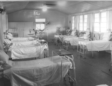 Kiewa Valley Historical Society
Photograph Tawonga Hospital, A ward at Tawonga Hospital, 1949/50
This photo is of a ward - probably the female ward, as there a many floral arrangements - of the original hospital at Tawonga. This was situated at the corner of Ryders Lane and Kiewa Valley Highway. The building was transported from Bonegilla where it was originally a part of the Bonegilla Military Hospital. The hospital was opened on 24th September, 1949 with a capacity of 12 beds, but was later increased to 35 beds by enclosing the verandahs on 3 sides of the building. 'Add ons' provided theatre, offices, stores and a nurses home. Construction was commenced by the Hospital and Charities Commission with considerable input from the S.E.C., providing the removal and re-erection of the building, the accommodation for nursing staff and carried all work necessary to make the building operational as a hospital. Up until this time the nearest hospital was at Yackandandah. The hospital remained on this site until 1961 when a larger, more suitable building was purchased in Mt. Beauty from the S.E.C.A photographic record of a typical open plan style ward in that era. There were no private rooms. There are portable screens stored at the end of the room to provide "privacy" at the bedside when needed. There is a fan on the wall for cooling. Depicts the rather primitive conditions of that era when compared with todays standards.Black and white photograph of a ward in the Tawonga District Hospitalhospital, ward, tawonga