Showing 1865 items
matching present day
-
 Eltham District Historical Society Inc
Photograph - Aerial Photograph, Landata, Eltham, Vic, Apr. 1963
... Centred on present day Eltham Lower Park bounded... melbourne Centred on present day Eltham Lower Park bounded ...Centred on present day Eltham Lower Park bounded by Brougham Street to north, Yarra River and Fitzsimons Lane Bridge to south, Main Road at Kent Hughes Road to east and Bolton Street to west. Historic Aerial Imagery Source: Landata.vic.gov.au Aerial Photo Details: Project No :486 Project : MELBOURNE (1963) PROJECT Run : 7 Frame : 232 Date : 04/1963 Film Type : B/W Camera : RC8 Flying Height : 5100 Scale : 9600 Film Number : 1805 GDA2020 : 37°44'03"S, 145°08'33"E MGA2020 : 336329, 5822040 (55) Melways : 21 H10 (ed. 42)aerial photo, neil webster collection, 1963-04, bolton steet, brougham steet, eltham, eltham lower park, fitzsimons lane bridge, kent hughes road, melway 21h10, yarra river -
 Eltham District Historical Society Inc
Photograph - Aerial Photograph, Landata, Eltham North, Vic, Apr. 1972
... Centred on present day Eltham North reserve near Eltham... melbourne Centred on present day Eltham North reserve near Eltham ...Centred on present day Eltham North reserve near Eltham North Primary School, Eltham North bounded by Allendale Road to north, Bellevue Road to south, Zig Zag Road and Beard Street to east and Ryans Road to west. Historic Aerial Imagery Source: Landata.vic.gov.au Aerial Photo Details: Project No :985 Project : MELBOURNE 1972 Run : 26 Frame : 190 Date : 04/1972 Film Type : B/W Camera : RC10 Flying Height : 5700 Scale : 9600 Film Number : 2636 GDA2020 : 37°41'52"S, 145°08'52"E MGA2020 : 336705, 5826102 (55) Melways : 11 J12 (ed. 42)aerial photo, neil webster collection, 1972-04, allendale road, beard street, bellevue road, eltham, eltham north, eltham north reserve, melway 11j12, ryans road, zig zag road, eltham north primary school -
 Eltham District Historical Society Inc
Photograph - Aerial Photograph, Landata, Research, Vic, Apr. 1972
... Centred on present day Main Road, Research near Maroondah... melbourne Centred on present day Main Road, Research near Maroondah ...Centred on present day Main Road, Research near Maroondah Aqueduct and Eltham College bounded by Allendale Road to north, Research-Warrandyte Road to south, Swipers Gully Training Restaurant to east and Reynolds Road to west. Historic Aerial Imagery Source: Landata.vic.gov.au Aerial Photo Details: Project No :985 Project : MELBOURNE 1972 Run : 26 Frame : 194 Date : 04/1972 Film Type : B/W Camera : RC10 Flying Height : 5700 Scale : 9600 Film Number : 2636 GDA2020 : 37°42'07"S, 145°11'07"E MGA2020 : 340015, 5825692 (55) Melways : 22 H1 (ed. 42)aerial photo, neil webster collection, 1972-04, allendale road, eltham college, main road, maroondah aqueduct, melway 22h1, research (vic.), research-warrandyte road, reynolds road, swiper's gully -
 Eltham District Historical Society Inc
Photograph - Aerial Photograph, Landata, Eltham, Vic, Apr. 1972
... Centred on present day Diamond Creek Trail at the Eltham... melbourne Centred on present day Diamond Creek Trail at the Eltham ...Centred on present day Diamond Creek Trail at the Eltham Leisure Centre bounded by Central Park to north, Main Road at Falkiner Street to south, MacMahon Ball Paddock to east and Grand Boulevard at Buena Vista Drive to west. Historic Aerial Imagery Source: Landata.vic.gov.au Aerial Photo Details: Project No :985 Project : MELBOURNE 1972 Run : 28 Frame : 207 Date : 04/1972 Film Type : B/W Camera : RC10 Flying Height : 5700 Scale : 9600 Film Number : 2635 GDA2020 : 37°43'25"S, 145°08'20"E MGA2020 : 335985, 5823223 (55) Melways : 21 G7 (ed. 42)aerial photo, neil webster collection, 1972-04, eltham, buena vista drive, central park, diamond creek trail, eltham leisure centre, falkiner street, grand boulevard, macmahon ball paddock, main road, melway 21g7 -
 Eltham District Historical Society Inc
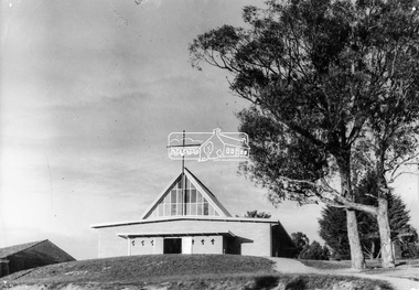
Photograph, George W. Bell, Our Lady Help of Christians Catholic Church, Henry Street, Eltham, c.1962
... had been situated on the main road near present day Wingrove... had been situated on the main road near present day Wingrove ...The second St Mary's Catholic Church Eltham was located at the corner of Main Road and Henry Street, Eltham and was opened/blessed October 13, 1912. The wooden church was built to replace an earlier brick church also known as St Mary's (1865-1912), which had been situated on the main road near present day Wingrove Park. The church and land cost £1,400 (Evelyn Observer). The wooden church was destroyed by fire in 1961. This modern (1960s) style church was built to replace the destoyed St Mary's and was called Our Lady of Help Christians. By this time Henry street had been closed off from Main Road.This photo forms part of a collection of photographs gathered by the Shire of Eltham for their centenary project book,"Pioneers and Painters: 100 years of the Shire of Eltham" by Alan Marshall (1971). The collection of over 500 images is held in partnership between Eltham District Historical Society and Yarra Plenty Regional Library (Eltham Library) and is now formally known as the 'The Shire of Eltham Pioneers Photograph Collection.' It is significant in being the first community sourced collection representing the places and people of the Shire's first one hundred years.Digital image 4 x 5 inch B&W Neg B&W printsepp, shire of eltham pioneers photograph collection, eltham, roman catholic church, churches catholic, main road, george w bell collection, our lady of help christians church -
 Eltham District Historical Society Inc
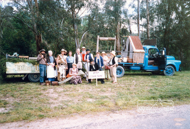
Photograph, Joh Ebeli, Best Eltham Theme, Eltham Festival Community Parade, 11 November 1989, 11/11/1989
... accompaniment. To provide a level of authenticity, a present day... accompaniment. To provide a level of authenticity, a present day ...Prize was a plate. Bruce Ness made the house on his truck. Joh Ebeli holding the sign. [from a contemporary report:] The Shire of Eltham District Society's Parade float theme for 1989 was gold mining which, of course, was a most important aspect of our early history. Bruce Ness assembled the float with items loaned by Warrandyte Historical Society and quite a bit of his own ingenuity. Phyllis MacDonald also arranged for the Victorian Folk Music Club to provide us with appropriate musical accompaniment. To provide a level of authenticity, a present day prospector, Jack Hodson, was in charge of the equipment on the float. The parade assembled in Youth Road and commenced at 10:30am.Colour photographeltham festival, shire of eltham historical society, 1989, central park, bruce ness, joh ebeli -
 Wodonga & District Historical Society Inc
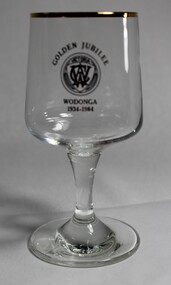
Memorabilia - CWA Wodonga Golden Jubilee Wine Glass, 1984
... in the community until the present day. The CWA provided gathering... the present day. The CWA provided gathering opportunities for rural ...The Country Women’s Association of Victoria was formed 12 March 1928 and today has over 5,600 members. Its original aim was to improve conditions by community service, more especially as they affect the welfare of women and children. The Wodonga CWA branch was formed in 1934 and has been an active group in the community until the present day. The CWA provided gathering opportunities for rural women and quickly became renowned for their street stalls, catering at Agricultural Shows and social events including debutante balls, handicraft classes and cooking demonstrations. Today they have become even more than that, participating in and organising a wide range of activities and initiatives in the community, always with the focus of service to others. The CWA is of significance on a local, state and national level as a critical service group. They conduct a range of social, educational and services throughout Australia with an initial focus on the support of rural women and children. This role has evolved over time to incorporate a wide range of initiatives, government advisory bodies and organisations.A wine glass decorated with a gold rim and gold logo of the CWA Victoria produced to celebrate the golden jubilee of the Wodonga BranchAbove the CWA logo "GOLDEN JUBILEE" Beneath the logo "WODONGA/1934 - 1984"country women's association, wodonga cwa, service groups, community organisations -
 Melbourne Legacy
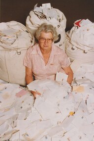
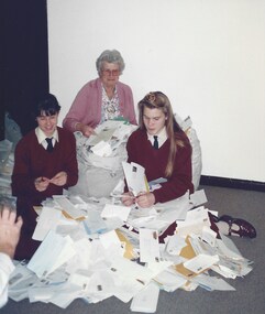
Photograph, Widows activities - Stamp Sorting, 1991
... for many years to the present day. It raises some funds... to the present day. It raises some funds and provides a purpose ...A Legacy widow, Beryl Billing, with three mail bags and a lot of loose letters. Beryl Billing was the co-ordinator of the stamp sorting for many years and wrote progress reports in the Answer in the 1990s. Photo reference 910319 on the proof sheet (00851) is assumed to mean the date was 19 March 1991. The widows clubs have sorted used stamps and sold to a stamp dealer for many years to the present day. It raises some funds and provides a purpose for gathering together. Later information found shows that Mrs Billings is the wife of a legatee and not a Legacy Widow. She started the stamp group in February 1981 and by 2006 the stamp sales had raised $206,698.A record of the type of activities Legacy provided as a social outlet for widows. Colour photo x 2 of Beryl Billing with post bags of letters.Label on the back from Keesing Photographic. Handwritten '910319B'widows, fundraising, stamps, beryl billing -
 Bacchus Marsh & District Historical Society
Map, Plan of Land at Bacchus Marsh, the Property of James Young, 1868
... beyond Gisborne Road in the vicinity of the present day Masons... beyond Gisborne Road in the vicinity of the present day Masons ...James Young was a prominent businessman, land owner and public figure in the early colonial period of Bacchus Marsh. In February 1868 he offered for sale through the agent W. Anderson 38 blocks of land which ran from the Lerderderg RIver westwards beyond Gisborne Road in the vicinity of the present day Masons Land. The land for sale was described as, 'unsurpassed Agricultural Land, in the immediate vicinity of Bacchus Marsh, varying in size from 2 to 12 acres each'. The sale notice in the Bacchus Marsh Express of 1st February 1868 page 2, also noted that, ' Plans can be seen at Mr. Young's Border Mills Store, and at the Border Inn'. One of the largest and most important land sales in the early colonial period of Bacchus Marsh.A single page paper map showing 38 blocks of land for sale in 1868 in the vicinity of Masons Lane Bacchus Marsh. Scale 11 chains to 1 inch. The map is pasted into a bound volume containing 76 maps or plans in total. High resolution digital image stored on BMDHS computer network. land sales bacchus marsh, bacchus marsh victoria maps, james young 1816-1871, masons lane bacchus marsh land sales -
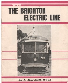 Ballarat Tramway Museum
Book, Leon Marshall -Wood, "The Brighton Electric Line", 1956, 1958
... photographs, map 1905 and present day (when printed), rolling stock... photographs, map 1905 and present day (when printed), rolling stock ....1 - Twenty page booklet on the history of the Brighton Electric Line by Leon Marshall-Wood, published 1956. Gives a brief history of the electric tramway operated by the Victorian Railways between St. Kilda Station and the Brighton Beach railway station, that commenced operation in 1905. The booklet was priced 2/-, published by the Traction Publications. Has 18 photographs, map 1905 and present day (when printed), rolling stock roster and notes and on the rear cover has details of the AETA. Front cover has horizontal crimson stripes. Has details of the AETA on the back cover and listing of some publications. Second copy from Ian Stanley added 24-1-2016. .2 - as for above - second edition, 1958, similar text, different photo layout and different front cover photo. See Reg Item 7631i for a scan of the 1966 edition.On front cover of first copy of .1 - top right hand corner; "N.Z.R.L.S / with compliments" and initials. Under title of book, "Price to Society 18/- Aust. per doz. / Retails 2/-" On page 3 of second copy of .1 - "Ian J Stanley 28 Park Road, South Camberwell, SE6, BK3746" On page 3 of .2 - "Ian J Stanley" in ink.trams, tramways, vr, melbourne, brighton, st kilda -
 Bacchus Marsh & District Historical Society
Map, Plan of the property of Messers Atkins and Clarke to be sold at the Mansion, Bacchus Marsh 19th April 1856. Copy 1
... portions. The land for sale is bounded by the present day streets... portions. The land for sale is bounded by the present day streets ...This plan of land allotments for sale indicates the property once owned by the Bacchus family in and around the township area of Bacchus Marsh. The Bacchus family sold their property in Bacchus Marsh to John Atkins and Robert Nalder Clarke in March 1851. Atkins and Clarke kept the property for a number of years until April 1856 when these allotments were put up for sale.This plan is almost identical to another copy held by the Bacchus Marsh and District Historical Society, VC Record 452, BMDHS collection). This plan, VC Record 707 Copy 1, contains a little more detail overall than VC Record 452 Copy 2, such as who did the survey work for the plan (R.C. Bagot) and who the selling agents were, (W.M. Tennent), and on the right side of the plan near the Lerderderg River is indicated the general area for a second parcel of land from this sale which is to be sold. There is also a compass illustration indicating north and south compass points.This is a very early land sales plan for the township of Bacchus Marsh and it therefore provides some clues as to how the early urban development of the township took place. Upon seeing the map in 1911 Bacchus Marsh Express newspaper editor Christopher Crisp wrote "The sale appears to have created the present township, which had a nucleus in earlier times further east", Express, 30 September, 1911, page 3.A single page paper plan showing allotments of land for sale. The subdivided land shown was owned by John Atkins and Robert Nalder Clarke, but previously owned by the Bacchus Family and was in and around their Manor House (Mansion) property in Bacchus Marsh.There are 5 portions of land further divided into numerous small portions. The land for sale is bounded by the present day streets of Main Street, Young Street, McFarland Street, Morton Streets, Crook Street, and part of the eastern section extends to the Lerderderg River. Scale: 8 chains to 1 inch The plan is pasted into a bound volume containing 76 maps or plans in total. BMDHS Loc: AR/B12/S4 Bacchus Marsh Township and Nearby Districts Maps Volume In-house Digital copies: BMDHS, Computer Network: Maps\Bacchus Marsh Township and Nearby Districts Maps VolumeHeading: Plan of the first portion of land. The property of Messers Atkins and Clarke situate at Bacchus Marsh. To be sold by W.M. Tennent & Co. at the Mansion on the Ground on Saturday the 19th April 1856. Below heading: Jas Ferguson, Lithographer On upper right side: Subdivided by R.C. Bagot London and Liverpool Chambers, Melbourne. 'Thos Taubman'. Post Office Stamp: BACCHUS MARSH VICTORIA MY 6, 63bacchus marsh victoria maps, bacchus family, land sales, manor house bacchus marsh -
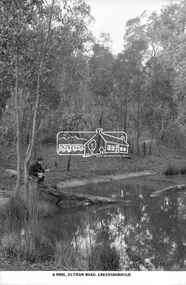 Eltham District Historical Society Inc
Photograph, The Rose Stereograph Company, A Pool, Eltham Road, Greensborough, c.1920
... to Greensborough (present day Sherbourne, Karingal and St Helena roads... to Greensborough (present day Sherbourne, Karingal and St Helena roads ...A boy of about ten years of age sits on the end of a fallen tree, which is resting in a natural pool in bushland. He is holding a stick gazing into the pool waters. He appears to be dressed in a schoolboy's uniform with close fitting short peaked cap, dark scarf or long sleeved jumper with polo neck and what appears to be a logo on the left breast, the ends of the sleeves turned over, dark shorts and dark long socks with ankle height lace up leather boots. The pool is located on the Eltham Road to Greensborough (present day Sherbourne, Karingal and St Helena roads) and is possibly part of the Karingal Yalloc somewhere near present day Ramptons Road Reserve. This glass plate negative was used to manufacture postcards (1:1 printing) for commercial sale by the Rose Sterograph Company and its subsidiaries. George Rose founded the Rose Stereograph Company in 1880 and was joined by Herbert (Bert) Cutts in the early 20th Century. The pair formed a lifetime working partnership and strong personal friendship. Assisted by George’s two sons, Herbert George and Walter, and later by Neil Cutts, the Rose Stereograph Company continued its operations for more than 140 years. The company was initially built on stereographs, but as cinema took over and stereographs fell out of fashion, the Rose Stereograph Company developed Australia’s first commercially viable photographic postcard business. Specialising in postcards of iconic historical moments and significant landmarks, The Rose Stereograph Company became a staple of the Australian travel industry.This remarkable collection of glass plate negatives, transparencies, and postcards – arguably Australia’s most significant photography collection outside of public hands – has been passed down through the generations, surviving war, relocation, and the harsh Victorian climate. The historic Rose Stereograph collection is the culmination of George Rose’s dream of capturing and preserving precious moments in time and remains the legacy of the Rose and Cutts families. It is with great sadness that the Cutts family says goodbye to a collection that spans five generations and 140 years. The Cutts family understands that for these historically important pieces to rest with one family is to deny others the pleasure of their custodianship.Glass Plate Negative Size: 9 x 14 cmA Pool, Eltham Road, Greensborougheltham, postcard, travel, rose stereograph company, glass plate negative, eltham road, greensborough, karingal road, karingal yallock, sherbourne road, st helena road, rampton's road reserve, schoolboy, peter and elizabeth pidgeon collection -
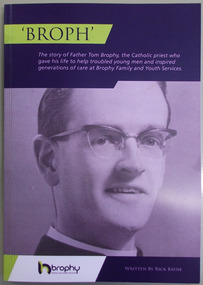 Warrnambool and District Historical Society Inc.
Book, Broph: the story of Father Tom Brophy, 2014
... and the present day Brophy Family and Youth Services organization. ... and the present day Brophy Family and Youth Services organization ...This is the story of the work of Father Tom Brophy, mainly concentrating on his work with youth in Warrnambool. Ordained as a Catholic priest in 1962, Fr Brophy worked in Ballarat and established a Ballarat Youth Centre and a Hostel for young men. He was moved to Warrnambool and arrived in early 1972. Although in Warrnambool for just two years Fr Brophy had an enormous impact in the community, establishing the Freedom Zone Youth Centre and the Warrnambool Home for Boys. He died at the early age of 45 and was buried in Warrnambool with a large number of local people attending his funeral. A Brophy Memorial Hostel was established and later developments include a Youth Centre in Timor Street and the present day Brophy Family and Youth Services organization. This book is of some importance as it outlines the work in Warrnambool of Father Tom Brophy, a Catholic priest whose name has become synonymous in Warrnambool with youth projects. He is one of the important community workers in Warrnambool in the 20th century and this book details his contribution and impact.This is a paper back book with a blue/yellow cover with a photograph of Father Tom Brophy in bluish tones on the front cover. It has 109 pages and contains printed material, photographs, illustrations and copies of newspaper extracts. The pages are glued together. Front cover: ‘Broph’ – The Story of Father Tom Brophy, the Catholic priest who gave his life to help troubled young men and inspired generations of care at Brophy Family and Youth Services. Brophy Family and Youth Services (logo) Written by Rick Bayne fr tom brophy, warrnambool, brophy house, brophy youth services, warrnambool freedom zone 1970's -
 Eltham District Historical Society Inc
Photograph - Aerial Photograph, Landata, Eltham, Feb. 1956
... Centred on present day Culla Hill and Petty's Orchard... melbourne Centred on present day Culla Hill and Petty's Orchard ...Centred on present day Culla Hill and Petty's Orchard, Eltham bounded by Brougham Street and Mount Pleasant Road to north, Monckton Road, Templestowe to south, Reynolds Road to east and Eltham Lower Park and Hohnes Road to west. Historic Aerial Imagery Source: Landata.vic.gov.au Aerial Photo Details: Project No :250 Project : MELBOURNE OUTER SUBURBS PROJECT Run : 18 Frame : 92 Date : 02/1956 Film Type : B/W Camera : EAG9 Flying Height : 10000 Scale : 12000 Film Number : 1176 GDA2020 : 37°43'35"S, 145°09'31"E MGA2020 : 337735, 5822959 (55) Melways : 22 B8 (ed. 42)aerial photo, 1956-02, neil webster collection, eltham, brougham steet, culla hill, eltham lower park, hohnes road, melway 22b8, monckton road, mount pleasant road, petty's orchard, reynolds road, sweeneys lane, templestowe, yarra river -
 Eltham District Historical Society Inc
Negative - Photograph, Tom Prior, Langlands Bridge, Eltham, c.1900
... used to run between present day Progress Road and Coleman... used to run between present day Progress Road and Coleman ...It is noted in the Reynolds Prior collection (Ivy Reynolds) as the first bridge in Eltham however given the current state of knowledge, this is considered unlikely and there is no other supporting source. John Hunter Langlands, owner of the farm known as ‘Ihurst’ on the west side of Diamond Creek to the south of John Wright Murray’s land, died in 1907. In 1909 his land was subdivided into 100 lots to become the ‘Glen Park Estate’. It is possible that the bidge may have crossed the Diamond Creek to Langland's land along the original alignment of Glen Park Road which used to run between present day Progress Road and Coleman Crescent. SEPP Source (c.1970): Mrs. E.R. Reynolds, Thompson Crescent, Research The Reynolds family were early settlers in Research. The Reynolds/ Prior collection of photographs were taken by Tom Prior, the maternal uncle of Ivy Reynolds, around 1900 and the 60 photos in the album give a fine overview of many of the landmarks of Research and Eltham over 100 years ago. lvy lived in the family home for many years at 106 Thompson Cres Research. Ivy's father, Ernst Richard Reynolds and grandfather, Richard Reynolds, lived at the same address. Ivy's father Richard worked for Mr. Trail on his property in Research. Reynolds Road is named after the family. Mr Tom Prior (wife Eva) worked at the Melbourne zoo. He was very innovative and made his own camera, using the black cloth hood to exclude the light. The photographs are a reminder of the rural nature of Research and Eltham and its rich heritage. This photo forms part of a collection of photographs gathered by the Shire of Eltham for their centenary project book,"Pioneers and Painters: 100 years of the Shire of Eltham" by Alan Marshall (1971). The collection of over 500 images is held in partnership between Eltham District Historical Society and Yarra Plenty Regional Library (Eltham Library) and is now formally known as the 'The Shire of Eltham Pioneers Photograph Collection.' It is significant in being the first community sourced collection representing the places and people of the Shire's first one hundred years.Digital image 4 x 5 inch B&W Neg B&W printsepp, shire of eltham pioneers photograph collection, eltham, langlands bridge, reynolds prior collection, bridge, john hunter langlands -
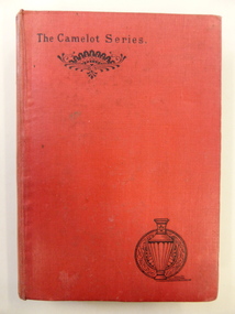 Warrnambool and District Historical Society Inc.
Book, Speaking Personally - W Murdoch, 1887/1888
... to the present day. It is notable for its charm and simplicity... to the present day. It is notable for its charm and simplicity ...These two important books are part of a series produced in the 1880s but they have widely-different content. One describes the natural history of the Parish of Selborne in the County of Hampshire in England. It was written by the British naturalist and ornithologist, Gilbert White and first published in 1789. Since that time it has been republished over 300 times right up to the present day. It is notable for its charm and simplicity and for its description of a pre-industrial England. The other is by the American author, Walt Whitman, first published in 1871. It is a major work of comparative politics and expounds on the influence of the Louisiana Purchase and the expansion of the American spirit and character. It also denounces the post-Civil War materialism that had spread at that time in America. These books are of interest because of their antiquarian nature but they are mostly of local Warrnambool interest because of their inscriptions. The books belonged to William Hugh McMahon (1862-1936). William McMahon commenced a legal practice in Warrnambool in 1894, firstly in Liebig Street and later in Kepler Street. He was a prominent lawyer in Warrnambool for 30 years and a staunch adherent of the Presbyterian Church. He and his family lived at ‘Glenrye’ at the corner of Ardlie Street and Botanic Road, a site where the St. John of God Hospital was later established. These two accompanying volumes are in the Camelot Series (1887 and 1888). They are hard cover books with red covers and two ornamental patterns on the front cover (stylized urn and fan shapes). The urn pattern is repeated on the spines. ‘The Natural History of Selborne’ has 366 pages (a Preface and Chapters on the Natural History of Selborne, a Naturalist’s Calendar and Observations on Various Branches of Natural History) and ‘Democratic Vistas’ has 175 pages (a Preface and 12 Chapters). The latter has the remains of a label stuck to the front cover. The handwriting on the inside first pages are in black ink.Book One: ‘W.H.McMahon, June 24th 1889, Warrnambool’ Book Two: ‘W.H.McMahon, Sept. 4th 1891, Warrnambool’ gilbert white, english natural history, walt whitman, american politics, william mcmahon, solicitor, warrnambool., warrnambool history -
 Parliament of Victoria
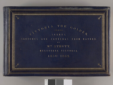
Victoria the Golden, Strutt, William 1825-1915, Victoria the golden : scenes, sketches, and jottings from nature, 1850-1862, 1850-1862, c.1895
... “fidelity to nature and accuracy”, so that present day Victorians... “fidelity to nature and accuracy”, so that present day Victorians ..."Victoria the Golden" documents life in Victoria between 1850 and 1862 as viewed by artist William Strutt. Momentous events in the Colony’s history such as Separation Day (1 July 1851), the sitting of the first Legislative Council (13 November 1851), the death of Burke (June 1861) and the Black Thursday bushfires (6 February 1851) are depicted. In 1907 the Premier of Victoria Thomas Bent purchased "Victoria the Golden" from Strutt for £120 and presented it to the Library. The album depicts events in chronological order with what Strutt considered “fidelity to nature and accuracy”, so that present day Victorians may view the sketches “as records of what we may now look upon as the dim past in the rapidly progressive history of Victoria”. Victoria the Golden is celebrated as one of the Parliament’s great treasures. It is a testament to William Strutt’s skill as a draughtsman and contains over 100 assorted images which were executed between the years of 1850-1862. Strutt’s particular talent was to be able to step back and record each event with particular care to detail. Many of the pieces contained within this album are littered with notes, such as the correct resting position of a corporal’s sword or details about the cloth and cut of a subject’s jacket. Strutt also notes in one of his many sketches of the new Legislative Council chamber at Spring Street that the President, Sir James Palmer, is seated ‘a little too high’ (page 30). Throughout the album, Strutt’s illustrations bring to life the diverse nature and peoples of the new colony. His range of subjects is comprehensive and includes parliamentarians, lawyers, wives and daughters, merchants, labourers, police and military officers, indigenous communities, farmers, miners, prisoners and explorers. The everyday and the extraordinary are depicted with each turn of the page. 44 leaves heavy card, approximately 1mm thick. Sketches, watercolours and prints of varying sizes and papers are glued onto the pages. Full leather binding in blue leather with title and decorative border in gold. There are four raised bands on the spine, with gold decoration on the bands and at the head and tail of the spine. Marbled end papers and flyleaves. Gold on the edges of the book block. Card pages have a sheet of mottled blue paper on recto. Album leaf connection is a guarded system with stiff stubs and cloth hinges. Each page has a sheet of glassine paper attached at the binding edge to protect the images. Many pages stamped with "Parliament of Victoria" verso. Printed in gold, recto: "VICTORIA THE GOLDEN/ SCENES,/ SKETCHES,/ AND JOTTINGS FROM NATURE./ BY/ Wm. STRUTT/ MELBOURNE, VICTORIA./ 1850-1862" First pages include handwritten 'introductory remarks' and index of plates.parliament of victoria, colony of victoria, separation day, victorian legislative council, burke and wills expedition, wills, william john, 1834-1861, burke, robert o'hara, 1821-1861, strutt, william, 1825-1915, bent, thomas sir, 1838-1909, native police corps, fawkner, john pascoe, 1792-1869, black thursday bushfires, gold rush, princes bridge, melbourne -
 Melbourne Legacy
Photograph, Keesing Photographic Pty Ltd, Widows activities - Stamp Sorting, 1992
... to the present day. It raises funds and provides a purpose for gathering... to the present day. It raises funds and provides a purpose for gathering ...Six school girls from Siena College came to Legacy house to meet the weekly gathering of the stamp ladies. They had chosen Legacy as a cause they wanted to help and decided to collect stamps, they donated over 5,000 stamps. The widows clubs have sorted used stamps and sold to a stamp dealer for many years to the present day. It raises funds and provides a purpose for gathering together. Photos included Beryl Billing, with two school girls from Siena College and a lot of loose letters. Also a cake and sandwiches enjoyed by the gathering. Beryl Billing was the co-ordinator of the stamp sorting for many years. This photo was featured on the back cover of The Answer newsletter in September 1992.A record of the type of activities Legacy provided as fundraising and a social outlet for widows. Also that Siena College was appreciated for collecting stamps.Colour photo x 4 of school girls from Siena College at Legacy House.widows, fundraising, stamps, beryl billing -
 Warrnambool and District Historical Society Inc.
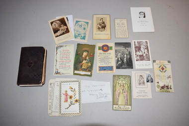
Book, Charles Eason, The Treasury of the Sacred Heart, C1920
... College in 1990 to form the present-day Emmanuel College... College in 1990 to form the present-day Emmanuel College ...This book of prayers was given by the Warrnambool Sisters of Mercy to Dorothy Ardlie on the occasion of her 12th birthday. The Sisters of Mercy came to Warrnambool in 1872 and established St. Mary’s Convent School, Wyton in North Warrnambool (re-named St. Ann’s in 1888). This school merged with the Christian Brothers College in 1990 to form the present-day Emmanuel College. The Sisters of Mercy ceased active involvement with the school in the 1990s. Dorothy Ardlie (1910-1993) and her sister Agnes Ardlie (1915-1993) were the daughters of Arthur and Ethel Ardlie of Warrnambool, the granddaughters of the prominent Warrnambool lawyer William Ardlie and his wife Mary and the great granddaughters of John and Mary Ardlie, pioneer settlers in Warrnambool. This book and the loose cards are interesting mementoes of Dorothy Ardlie, a member of a prominent Warrnambool family in the 20th century and of the Sisters of Mercy, an order of nuns that has been important in Warrnambool’s educational history. This is a book of 138 pages with a brown leather cover and gilt edging along the sides of the pages. The front and back cover and spine are embossed with two decorative patterns. The front cover has an embossed heart with flames and a cross and the spine has gold lettering. Some of the pages are loose and some have been re-attached to the binding using adhesive tape. Some of the pages are stained. The book contains black printing and there is one black and white illustration. In the pages of the book were 29 small cards, scraps of paper etc. These are now kept with the book but in a separate folder. Most of these are of a devotional nature – prayers, images of saints etc. Wishing dear Dorothy a very happy birthday with much love from the Sisters of Mercy 26th April 1922ardlie family, sisters of mercy, history of warrnambool -
 Hymettus Cottage & Garden Ballarat
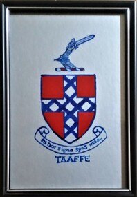
Painting, Taaffe Coat of Arms
... on glass in reverse by Glen Taffe in 1992 as a Father's Day present... as a Father's Day present for Michael Taffe. Painting, glass, Fathers ...A small painting of the Taaffe family coat of arms painted on glass in reverse by Glen Taffe in 1992 as a Father's Day present for Michael Taffe.painting, glass, fathers' day. -
 Warrnambool and District Historical Society Inc.
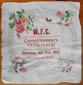
Ephemera - Serviette Warrnambool Football Club dinner 1933, 1933
... to the present day. As the venue for this dinner, the Commercial Hotel... it still plays to the present day. As the venue for this dinner ...Warrnambool Football Club was formed in June 1861 making it one of the earliest clubs formed in Australia and many of the earliest players and associates were members also of the Warrnambool Cricket club which was established around 1854. Games of various sized teams were played in the early years and it was in 1889 that the Warrnambool and District Football Association was formed. The year marked with the celebration of this dinner, was important in the club’s history as it marked their entry into the wider Hampden football league, where it still plays to the present day. As the venue for this dinner, the Commercial Hotel on the corner of Liebig and Timor Sts, was commonly used in the early days as a club meeting place. The history of the club was recorded in “The Birth of the Blues” by Ron Cole, Harry Keilar, Ron McCorkell and Ian Wright, in 2007.The Warrnambool Football club is one of the longest surviving sporting clubs in the Warrnambool district and as such, would have involved or touched the lives of many of its residents. This serviette marks a dinner which was an important event in the history of the Warrnambool Football Club. White crepe paper with circular bell pattern, which has been embellished in each corner with pink flowers and green leaves. Centre of circle printed in large red lettering.WFC Complimentary Dinner Saturday Oct. 21st 1933 Commercial hotel.warrnambool, warrnambool football club, wfc dinner 1933, commercial hotel 1933, commercial hotel -
 Eltham District Historical Society Inc
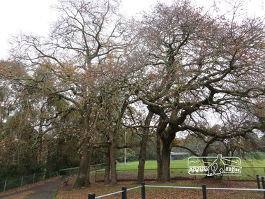
Photograph, Oak Trees and Eltham Rugby Football Club oval, Diamond Creek Trail, 21 June 2017, 21 June 2017
... industrial area at the end of present day Pitt Street near... industrial area at the end of present day Pitt Street near ...A walk around Little Eltham, 21 June 2017. Eltham’s first industrial area at the end of present day Pitt Street near the Diamond Creek. Just upstream a bit, near these oak trees was the flour mill. The most significant owner of that was Henry Dendy. Better known for founding Brighton but he lived in Eltham longer than he lived in Brighton, during the 1860s. There was also the brewery and slightly downsteam from here was the tannery. The brewery needed fresh clean water so it was upstream from the tannery. The Oak trees were most likely planted during Henry Dendy's time. (Source: Local historian commentary, Eltham Hidden Creek heritage excursion 7 March 2020) Born Digitaleltham community centre, diamond creek trail, eltham rugby football club, oak trees, henry dendy -
 Warrnambool and District Historical Society Inc.
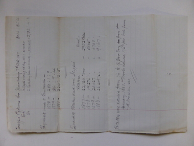
Document, Traffic Returns - Tramway, 1880
... the present day railway sheds past the site of the old Woollen Mill... Tramway ran from the south end of Fairy Street near the present ...This is a traffic report of the Warrnambool Tramway in 1880. The Warrnambool Tramway ran from the south end of Fairy Street near the present day railway sheds past the site of the old Woollen Mill, then extended towards the Warrnambool Bay on the easterly side of the site today of the Lady Bay Apartments and on to the Tramway Jetty. The Tramway was completed in 1858 and was horse-drawn. It was leased to private individuals until 1864 when the Warrnambool Council took over the management. The Tramway closed in 1890 when the Breakwater was opened and it had its own spurline from the railway station to the end of the Breakwater. The 1880 report shows that contractors were paid over £300 and that 26, 409 tons of potatoes and 9167 bales of wool were carried by the Tramway in that year. This report is of interest as it shows the operations of the Warrnambool Tramway in 1880. The Tramway was significant in the maritime history of Warrnambool.This is a single foolscap-size sheet with handwritten material concerning a report of the Warrnambool Tramway operations in 1880. The writing is in black ink. The page has a large red-lined margin on the left side. The sheet is a little stained where it has been folded.history of warrnambool, warrnambool tramway -
 Warrnambool and District Historical Society Inc.
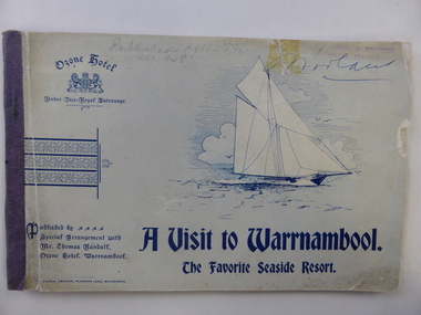
Booklet, A visit to Warrnambool, Early 20th century
... was burnt down and the present- day Hotel Warrnambool was built... was burnt down and the present- day Hotel Warrnambool was built ...This booklet was produced for Thomas Randall, the proprietor of the Ozone Hotel, Warrnambool, situated at the corner of Kepler and Koroit Streets. It was a publicity booklet given out gratis to prospective clients of the hotel. The Ozone Hotel was originally called the Grand Ozone Coffee Palace and opened in 1890 as a temperance hotel, a splendid building with over 100 rooms. In December 1891 the Coffee Palace was granted a Colonial Wine Licence and in 1895 it was re-named the Ozone Hotel. Thomas Randall was the proprietor from 1894 to 1907. In 1920 the Ozone Hotel, after being closed for some time, was re-opened as the Hotel Mansions and a full liquor licence was obtained in 1923. In 1929 the building was burnt down and the present- day Hotel Warrnambool was built on the site. This booklet is of great significance as it documents the splendor of the Warrnambool Ozone Hotel when it was at its best. This building is regarded as the finest and most elegant building ever built in Warrnambool and this booklet contains the only photographs we have of the interior of a 19th century/early 20th century hotel building in Warrnambool. This booklet is also of interest as it belonged to Henri Worland, the Town Clerk of Warrnambool from 1918 to 1949 and Warrnambool’s best-known historian. This is a soft cover booklet of 64 pages. The cover is blue-grey and has an image of a sailing ship, the logo of the Warrnambool Ozone Hotel and some ornamental scrolls. The printing on the front cover is blue. The back cover has two advertisements for Melbourne businesses. The booklet is stapled and bound with purple tape. The booklet contains black and white advertisements for Warrnambool and Melbourne businesses, an article on the town of Warrnambool and black and white photographs of Warrnambool and district and of the interior and exterior of the Ozone Hotel. Most of the pages contain some ornamental patterns. The front cover is a little ragged and torn. Signature of H.Worland on the front cover and on the first inside page. grand ozone coffee palace/ozone hotel/hotel mansions, history of warrnambool, thomas randall -
 Orbost & District Historical Society
Photograph - Orbost Agricultural Society Committee, 1902
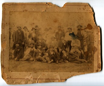
... continues to the present day (2023) as an annual event held in March... continues to the present day (2023) as an annual event held in March ...Moves to begin an Orbost Agricultural Show was started in 1891 and a Committee was formed. The Society's first Show was held on Tuesday 15 March 1892. The Orbost Agricultural Show continues to the present day (2023) as an annual event held in March. The Committee shown in this photograph are known to be President: John Johnstone; Vice Presidents: F Nixon, M Lynch, A E Rodwell; Secretary: Geo Perry Committee: S Lynn, Geo Answer, C Drevermann, J Bird, J Draffin, J Cummings, R Mosley, H James, A Saunders, P Morris, G Carter, A Pardew, Jas Nixon, J Gilbert, S Grenville, W Scharleman, G Nixon, H Richardson, J Hocking, J Fisher, J Hossack This photograph shows an early Orbost Show Committee which consists entirely of men. A badly yellowed and damaged b/w photograph onto cardboard. Both the image and the cardboard are damaged. The photograph is of a group of men, some sitting on the ground, some standing behind. Written onto the back of the photograph are these words: 1902 Orbost Agricultural Society Committeeagricultural show, orbost -
 Ballaarat Mechanics' Institute (BMI Ballarat)
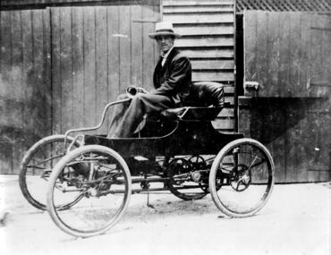
1901 Car built by Arthur, Rob, & Harold Leckie in Ballarat
... as an Ironmonger at 'The Present Day Ironmonger' in Bridge Street. He next.... He was Apprentice as an Ironmonger at 'The Present Day ...This photograph is held in the Ballaarat Mechanics' Institute Audio Visual Collection. Please contact BMI for all print and usage inquiries. Arthur Leckie was born in Sebastopol on 16 August 1876. In 1878 the family moved into their newly built home, Blythewood Grange, in Sebastopol. Arthur attended Grenville College and commenced Ballarat College in 1893. He was Apprentice as an Ironmonger at 'The Present Day Ironmonger' in Bridge Street. He next worked for William Dawson, Ironmonger, in Sturt Street, next to old The Courier Office. After the death of his father in 1893 the family moved out of ‘Blythewood Grange into Ballarat. Arthur and his brothers Robert and Harold built their own automobile in the sheds behind their house, commencing in 1899 and having it ‘on the road’ in 1901.ballarat, 1901, car, leckie -
 Ballaarat Mechanics' Institute (BMI Ballarat)
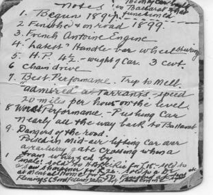
Notes on Arthur Leckie's Car 1899
... as an Ironmonger at 'The Present Day Ironmonger' in Bridge Street. He next.... He was Apprentice as an Ironmonger at 'The Present Day ...This photograph is held in the Ballaarat Mechanics' Institute Audio Visual Collection. Please contact BMI for all print and usage inquiries. Arthur Leckie was born in Sebastopol on 16 August 1876. In 1878 the family moved into their newly built home, Blythewood Grange, in Sebastopol. Arthur attended Grenville College and commenced Ballarat College in 1893. He was Apprentice as an Ironmonger at 'The Present Day Ironmonger' in Bridge Street. He next worked for William Dawson, Ironmonger, in Sturt Street, next to old The Courier Office. After the death of his father in 1893 the family moved out of ‘Blythewood Grange into Ballarat. Arthur and his brothers Robert and Harold built their own automobile in the sheds behind their house, commencing in 1899 and having it ‘on the road’ in 1901.ballarat, arthur leckie, car, 1899 -
 Linton and District Historical Society Inc
Photograph, Mrs. Bessie Brown and Daughter Vera
... (near present-day Pittong). She attended Spring Vale State... (near present-day Pittong). She attended Spring Vale State ...Elizabeth (Bessie) Mercer, a daughter of Henry Boyd Mercer and Deborah Mercer née Sinclair, was born 23/8/1873 at Spring Hill (near present-day Pittong). She attended Spring Vale State School where she achieved her Merit Certificate. She registered as a teacher in 1891 and completed further training to become a teacher of gymnastics in 1896. Bessie married David Brown of Chepstowe, and they farmed at Pittong. They had two children, Vera and Roy. Bessie Brown died in 1940. Bessie and her sister Emma were very involved with the war effort during World War I, and after the war they were presented with certificates of appreciation by the Linton "Diggers". (Copies of certificates in the LDHS collection.)Black and white copy of original photograph of a seated lady wearing dark skirt and blouse with a high neck and ruffles. Standing beside her is a girl wearing a light coloured knee length dress and black shoes and socks. She is also wearing glasses, a cameo necklace and a white bow in her hair."Mrs Bessie Brown + daughter Vera".elizabeth (bessie) brown née elizabeth mercer, vera brown -
![Map, Plan of Subdivision [Allotments along Lerderderg, George and McFarland Streets]](/media/collectors/5e461d8021ea67224c82f2a1/items/675d7243165f146b8adfc656/item-media/675d72d7165f146b8adfc859/item-fit-380x285.jpg) Bacchus Marsh & District Historical Society
Bacchus Marsh & District Historical SocietyMap, Plan of Subdivision [Allotments along Lerderderg, George and McFarland Streets]
... of the present day Bacchus Marsh Primary School. There are also... of the present day Bacchus Marsh Primary School. There are also ...This map shows allotments of land on the northern side of Lerderderg Street from Gisborne Road through to the approximate site of the present day Bacchus Marsh Primary School. There are also allotments shown on the southern side of McFarland Street between George Street and Gisborne Road. Larger allotments of land are shown extending northwards towards Masons Lane. Inscribed at the top of the map are the words, 'Plan of Subdivision of Cr Pors (Crown Portions) 12 & 13 & Allotments 1,2,3,4, Block 3, Parish of Korkuperrimul, County of Bourke'. The date of the map has not been established but the absence of the Bacchus Marsh Primary School on the map suggests it may have been produced prior to 1865 when the primary school was built in Lerderderg Street.Single page map showing house block size land allotments in the Lerderderg, George Street and McFarland Street area of Bacchus Marsh with larger allotments north of this area towards Masons Lane also shown. Scale 150 feet to 1 inch. Part of a set of maps which are pasted into a bound volume containing 76 maps or plans in total. High resolution digital image stored on BMDHS computer network. bacchus marsh victoria maps, lerderderg street land allotments, mcfarland street land allotments -
 Eltham District Historical Society Inc
Photograph - Colour Print, Belle Vue, Livingstone Road, Eltham, c.2015
... Eltham farmer Henry Stooke, the present-day old farmhouse sits... Eltham farmer Henry Stooke, the present-day old farmhouse sits ...Belle Vue property in Livingstone Road, Eltham was once owned by Society member Jo McCormick. Jo was a valued member of our committee and dear friend of many of our members until her death in 2009. Belle Vue is the farmhouse of a property that is now a significant part of suburban Eltham, just a short distance north of the town centre. Originally purchased by pioneer Eltham farmer Henry Stooke, the present-day old farmhouse sits within an extensive suburban residential area. The history of the property is largely based on a heritage assessment prepared by consultant Lorraine Huddle for Nillumbik Shire Council. Additional information from our Society records reveals Belle Vue farm comprised about 56 ha (140 acres) extending northerly from the northern boundary of Holloway’s 1851 Little Eltham subdivision. On the present day map the southern boundary was just north of Elsa Court and Grove Street. The western boundary was the Diamond Creek and extended northerly to Main Road where it turns easterly towards Research. It was traversed by the main road to Kangaroo Ground and beyond and from 1912 by the railway to Hurstbridge. From 1895 the farm was owned by William Williams and his wife Mary Ann. In 1914 -15 they built a new house now known as Belle Vue. They sold the land in 1920 and residential subdivision began soon after that. Belle Vue remains today on a substantially subdivided and very much reduced size residential lot in Livingstone Road. The house and many old trees on the site were subject to a heritage overlay under the Nillumbik Planning Scheme. Despite that overlay, the development and subdivision of the original land resulted in most of the heritage listed trees being removed. belle vue, eltham, livingstone road