Showing 1469 items matching "site no 2"
-
 Warrnambool and District Historical Society Inc.
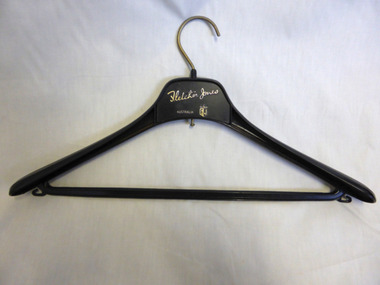
Domestic object - Fletcher Jones Coat Hanger, Late 20th century
David Fletcher Jones commenced his tailoring and hawking business in the 1920’s. The business expanded through the decades to become the main manufacturing employer in the city of Warrnambool. The business moved from Liebig Street around 1947 to a site in East Warrnambool which was once an old quarry. The factory which was built at “Pleasant Hill” manufactured quality clothing, initially men’s trousers, suits which expanded in later times to include ladies’ wear. A network of stores was opened throughout Australia to sell the garments. A common item linked to a significant business and personality of Warrnambool.Fletcher Jones Factory held a significant place in the economic development of the city. The Fletcher Jones Gardens remain a significant landmark in the cityBlack plastic coat hanger with metal hook. Fletcher Jones in gold lettering below the hook.warrnambool, fletcher jones, pleasant hill, fletcher jones gardens, coathanger -
 Warrnambool and District Historical Society Inc.
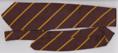
Textile - Warrnambool Primary School 1743 Tie, Circa 1950’s
Warrnambool State School, No, 1743 was opened in 1876. The site in Jamieson St was easy to access from the surrounding areas of Belfast, Woodford, and Allansford roads. It was the main school in Warrnambool, before the development of Primary schools at East and West Warrnambool. A large part of Warrnambool’s children have attended this school over the 140 years it has been in existence.A common item with which a large number of Warrnambool residents would identify. Brown woven woollen tie with diagonal yellow stripes. White tag with black and red writing sewn into back seam.Tee- Dee, pure wool, school and college wear. warrnambool, warrnambool jamieson street primary school, no 1743, school tie, warrnambool primary school -
 Warrnambool and District Historical Society Inc.
Souvenir - Warrnambool Soldiers Memorial saucer, Mid 20th Century
The War Memorial was constructed in 1925 on Merri Street at the South side of Liebig St. It was constructed to commemorate the soldiers of WW1. It is constructed of red granite and the Angel is carved in marble. Adjacent to it is the RSL clubrooms.The Warrnambool War Memorial is a significant space commemorating a significant event and situated in one of the most prominent sites within the city. The image on this item would therefore be a typical memory which visitors would like to take from our city.White china saucer with gold rim and black print of the Warrnambool War Memorial. Soldiers Memorial Warrnambool. On rear Royal Stafford, guaranteed English Bone China. Made in England warrnambool, warrnambool war memorial -
 Warrnambool and District Historical Society Inc.
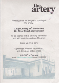
Card - Invitation to the opening of The Artery, 2014
The Artery is an artists’ workshop and gallery building housed in the old Guyetts Funeral Parlour in Timor Street. The opening of the gallery was on 28th February 2014 with a smoking ceremony and music by Jackson McLaren.This card is of minor importance only. It gives us the date of the opening of the site of a Warrnambool artists’ organization.This is a small card with black printing on a white background with a blue-toned image of The Artery building. The Artery and other wording regarding the opening of the artists’ workshop and gallerywarrnambool, art -
 Warrnambool and District Historical Society Inc.
Book, Warrnambool Botanic Garden Masterplan, February 1995
This Warrnambool Botanic Gardens Study and Report was funded by the National Estate Grants Program of the Australian Heritage Commission and the City of Warrnambool. It was monitored in progress by a Steering Committee consisting of representatives of the Botanic and Public Gardens Advisory Committee, the Warrnambool City Council, Friends of the Warrnambool Botanic Gardens and National Estate Grants Program representatives and community representatives. The Warrnambool Botanic Gardens were first sited close to the Hopkins River in 1859. In 1869 the gardens were relocated to the present day location in Botanic Road. This plan is of some importance as it gives an overview of the history and current condition in 1995 of the Warrnambool Botanic Gardens and draws up a plan for its future development. It is useful for research and for consideration by the City Council today of policy making and further development of the gardens. This is a publication containing a master plan for the Warrnambool Botanic Gardens. It has a section on acknowledgements, a summary, eight chapters, and 14 appendices. The pages are bound with plastic rings, the front cover is plasticized with an aerial photograph of the Botanic Gardens and surrounds and the back cover is lightweight cardboard. The pages contain printed material, fold out maps, sketches and diagrams and many photocopied photographs.Front Cover: City of Warrnambool, Warrnambool Botanic Gardens, Conservation and Development Plan, Jill Orr-Young, Patrick Mallon, SF Consultants Pty Ltd, February 1995. warrnambool botanic gardens, warrnambool -
 Warrnambool and District Historical Society Inc.
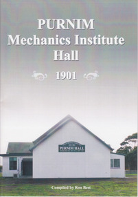
Booklet, Ron Best, Purnim Mechanics Institute Hall 1901, 2014
Brief history of Purnim Mechanics Institute HallThis is a paper back book of 24 pages. It has a white back cover and a grey/white front cover with a coloured photograph of the second Purnim Hall. The printed material is black on a white background. non-fictionBrief history of Purnim Mechanics Institute Hallpurnim, mechanics’ institutes, warrnambool -
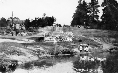 Eltham District Historical Society Inc
Negative - Photograph, Village Pond, near Main Road, Eltham, c.1908
Village Pond, near Main Road, Eltham, c.1908 Reproduced on p57 of 'Pioneers & Painters'. Looking up Dalton Street from across Maria Street (Main Road), near Whitecloud (Jarrold’s cottage) and the Bootmaker’s cottage, to the left (out of view) of the photographer. The residence of the Head Teacher, Eltham State School No. 209, can be seen on the right, the Grant house on the left (site of present day Eltham Clinic). The willow trees south of Jarrold’s Cottage today mark the site of the old pond, which the Eltham Shire Council evidently filled in to stop mosquitos breeding. The pond and its locality was described in an article about Eltham published in The Australasian, May 2, 1903 - “There is the village pond (so essentially English), reflecting in its clear water a quaint cottage, dwarfed by a huge gum tree, an old smithy, and a hostelry, built quite fifty years ago, the flooring-boards of which the landlord informed me with pride were of Singapore cedar, and quite fit for another fifty years' wear. Then there are the village school, the shoemaker's, the drapery store, and the butcher's shop, all seemingly as they were when first they were erected many years ago.”This photo forms part of a collection of photographs gathered by the Shire of Eltham for their centenary project book,"Pioneers and Painters: 100 years of the Shire of Eltham" by Alan Marshall (1971). The collection of over 500 images is held in partnership between Eltham District Historical Society and Yarra Plenty Regional Library (Eltham Library) and is now formally known as the 'The Shire of Eltham Pioneers Photograph Collection.' It is significant in being the first community sourced collection representing the places and people of the Shire's first one hundred years.Digital image 4 x 5 inch B&W Neg Print 16.5 x 25 cm (2) and 9 x 12.5 cm Postcard 9 x 14 cmOn one print "57 and 11 3/8' x 10' deep"shire of eltham pioneers photograph collection, dalton street, duck pond, eltham, grant house, main road, maria street, village pond -
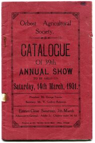 Orbost & District Historical Society
catalogue, Snowy River Mail, 1931
This catalogue is for the 39th Annual Orbost Show held in 1931. Admission was 2/- for adults and 6d for children under 14. The first meeting to form an Agricultural society in Orbost was convened by the then Orbost Progress Association and held in the Mechanics Hall on Saturday, 10th October 1891. Its first show was held on 3rd March 1904...on a site alongside the Bonang Road where the present Golf Club stands. It is currently held at the Recreation Reserve at Newmerella.(Ref: In Times Gone By-Deborah Hall)This item is associated with the Orbost Agricultural Society 's Annual Show which has been a major event in Orbost for over a century. Agricultural shows are an important part of cultural life in small country towns and the Orbost Show is an integral part of Orbost 's agricultural history. A thin side stapled paper catalogue for the 39th Orbost Annual Show. It has a red cover and black print"Catalogue of 39th Annual Show Saturday 14th March 1931". It contains details of entry requirements. There are also advertisements for local businesses. 755.1 is a complete stapled photcopy.orbost-agricultural-society orbost-events -
 Ringwood and District Historical Society
Photographs, Demolition of the Ringwood Mail premises in Maroondah Highway, 2011
... of Ringwood Mail premises - note the Ringwood Mail sign.; 2... the Ringwood Mail sign.; 2. Demolition site - note the 'Award Winning ...Collection of three Ringwood photographs:; 1. Demolition of Ringwood Mail premises - note the Ringwood Mail sign.; 2. Demolition site - note the 'Award Winning Dealership' sign.; 3. Demolition site - note the 'Award Winning Dealership' sign. -
 Ringwood and District Historical Society
Photographs, Construction Stage of historical Miner's Cottage Museum completed 1983, and panoramic view of partial construction of commercial buildings on former Ringwood Market site, Seymour Street, Ringwood c.1970s. On cardboard
3964/1 15 photographs on cardboard 76cmX51cm depicting construction stages of historical Miner's Cottage Museum completed 1983; 3964/2 4 photographs on cardboard 85.5cmX22.5cm forming panoramic view of partial construction of commercial buildings on former Ringwood Market site, Seymour Street, Ringwood c.1970s -
 Ringwood and District Historical Society
Photograph, Last remaining house on Eastland Shopping Centre site in Ringwood - 1985, 1985
Photos (3) of the former McKinley home (Mayor 1927/28) and later Rymers' at 22 Adelaide Street, Ringwood, Victoria, 1985, prior to demolition for expansion of Eastland Shopping Centre. Covering letter from Connie White, 2014. 1. Ringwood house (Myer car park) 1985 shot 2. Ringwood - old house, Myer car park 3. Ringwood old house - Myer car park -
 Ringwood and District Historical Society
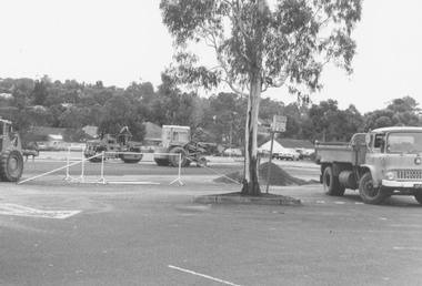
Photograph, Ringwood cool store demolition site, 1962
Black and white photograph (1 large, 2 small copies)Typed below large photograph: "Overlooking the cool store site, 1962". Written on back of small photograph: "Cool store site cleared. Taken from top of Town Hall." -
 Ringwood and District Historical Society
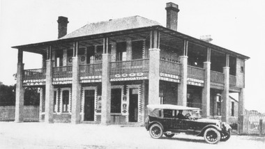
Photograph, Club Hotel, Mount Dandenong Road, Ringwood East in 1924, 1924
Black and white photograph of the Club Hotel on Mount Dandenong Road, East Ringwood. The image was copied from the "Ringwood East Electric Station Estate" land sales brochure dated 1st November 1924. Refer to #5132. The hotel has a long association with the Reddish family, thus given the name of "Daisy's Hotel". Included 2 copies of the photograph. Ryman Healthcare bought the site in 2019, including the garden supply business next door, making up a 2.2ha area. The proposal was for a $220 million retirement village to be built. The location is next to Ringwood Lake with the old hotel being knocked down in the early 2020s.Was item H7 in the previous numbering system. -
 Ringwood and District Historical Society
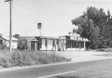
Photograph, Burnt Bridge Store, Feb 1960 (2 views)
Written on back of one photograph, "Burnt Bridge Store. Demolished 1969. New World super market and shops built on or about site. Feb. 1960". On another copy "Ex BB Hotel, Demolished 3-4.69". On another copy: "Old Burnt Bridge Hotel (Sam Cutts)" -
 Ringwood and District Historical Society
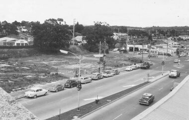
Photograph, Site of clock tower after removal., Ringwood. 1967 (2 views)
Written on back of photo SS0195., "Site of clock tower looking up Warrandyte Rd., 1967". On SS0197: "Site of clock tower, June 1967" -
 Ringwood and District Historical Society
Photograph, The site of Roy Wilkins house, Ringwood. Council equipment paving adjacent areas. 1982
... areas - 12/2/82". The site of Roy Wilkins house, Ringwood ...Written on back of photograph, "The site of Roy Wilkins house. Council equipment paving adjacent areas - 12/2/82". -
 Ringwood and District Historical Society
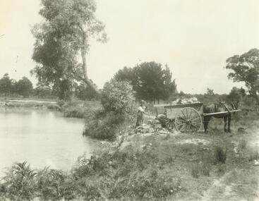
Photograph, 'The Dive' East Ringwood Knaith Rd. (undated). 2 views (undated)
View of lake with man shovelling rubbish into it from cart with horse. RE0028 shows close up view of same man. See also Item 2978 (Image RE0029) for full view of The Dive including Diving Tower.Typed below photograph, "'The Dive' East Ringwood Knaith Rd. where the aquatic sports were held. Being filled in after several drownings. Was clayhole from a brickworks. Now site of Ringwood East Community Centre". (3 copies) -
 Ringwood and District Historical Society
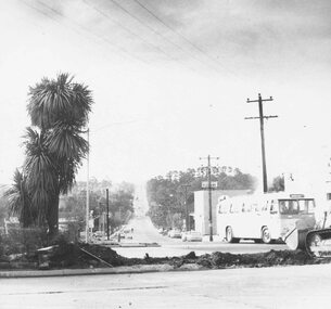
Photograph, Old Baths Site bulldozed, Ringwood Late 1980 (2 Views)
... Old Baths Site bulldozed, Ringwood Late 1980 (2 Views)..., "Lat '80. Old baths bulldozed. Ringwood Street." Old Baths Site ...Written on back of photographs, "Lat '80. Old baths bulldozed. Ringwood Street." -
 Orbost & District Historical Society
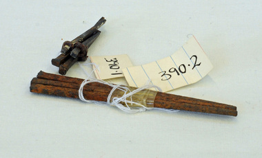
nails, 1890's
These hand-made nails were used in what was Temple's Store built in 1889. It later became Herbert's - now demolished and is the present site of the Foodworks Supermarket.Temple's store was on the corner of Ruskin Street and Nicholson Street. George Temple (1832-1918) established the store in about 1888. He packed stores to the Bendoc area gold fields.Two lots of hand-made nails. .1 is a set of five small nails tied together with string. .2 is a set of three longer nails which are very rusty.nails metal-working temples-store -
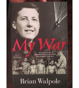 Australian Commando Association - Victoria
Book, My War: An Australian Commando in New Guinea and Borneo 1943 to 1945
Brian Walpole, the author, was a Australian Commando and special operations operative behind enemy lines in New Guinea and Borneo during WW2. Brian was a commando with the Australian 2/3 Independent Company. He went to New Guinea in January 1943 and remained until the fall of the Japanese base at Salamaua in September. He fought on the Bobdubi Ridge. His commanding officer was the well-regarded George Warfe, whose portrait was sketched by war artist Ivor Hele. Brian blazed a trail through the New Guinea jungle which appears on some maps as Walpole’s Track, discovering and naming the ambush site Goodview Junction. Soon afterwards (July 1943) Goodview Junction was the scene of a key campaign victory which contributed to George Warfe being awarded the Military Cross.Brian’s Special Operations training mostly took place at Careening Bay (Western Australia) and Fraser Island (Queensland). He arrived in Borneo at the time of the 9th Division’s landing at Labuan Island, and took part in two SRD operations – Colt and Semut 3. After the surrender, Walpole's work continued as many of the Japanese did not recognise the surrender and continued to fight on. Brian relates how on the 14th of September 1945 while still an operative in SRD he was able to save POWs from certain death and after a firefight arrested 10 Japanese soldiers at Simanggang Borneo. He was alone and had been assisted in the battle by 20 headhunters from the jungles along the Rejang River. One of the people saved was a young nurse in her 20s, Lena Ricketts. ww2, australian special operations, australian commando, new guinea, borneo, world war ii -
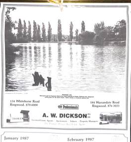 Ringwood and District Historical Society
Souvenir - Complimentary A.W.Dickson Real Estate Agents calendars, Complimentary A.W.Dickson Real Estate Agents calendars - 1987 and 1988.1987 calendar with photographic images of local Ringwood features and 1988 calendar featuring local Ringwood land sale promotional images from early 20th Century
A.W.Dickson was a Real Estate Agent in Ringwood for many years. These calendars show the local buildings of the day. For example the original Eastland 's building of 1967, Maroondah Hospital 1976 and the Civic Centre now the Karralyka Centre.1 1987 calendar with six black and white photos of buildings and vistas around Ringwood with monthly dates in lower quarter of page. 2 1988 calendar with six posters advertising early 20th century land sales in Ringwood, Heathmont and Ringwood East with dates in lower quarter of page Compiled by A.W.Dickson Pty. Ltd. Real Estate Agent. Photographed by C.M.S. Photographers - 725 9441 (January February 1987) RINGWOOD LAKE - Ideal picnic spot for Ringwood Model power boats frequently on display. Barbecue area, playground, resting place for old steam engine. Yabbie netting is a favourite pastime here. (March April 1987) CLOCK TOWER - Moved from its former site on Warrandyte Road corner in 1967 and re-built in its present location, brick by brick. A wreath laying ceremony is held here on Anzac day each year. (May June 1987) RINGWOOD AQUATIC CENTRE - A world class swimming facility opened in 1986 at a cost of $3 million. Featuring the latest ozone water treatment techniques. In summer folding doors can be opened to give access to existing outdoor pools and sunbathing area. (July August 1987) MAROONDAH HOSPITAL - Opened in 1976 after many years of fund raising efforts by local people. The opening of casualty facilities was welcomed by locals as previously Box Hill Hospital catered for the entre area. (September October 1987) EASTLAND - Opened October 1967. Built on a former football oval. Now about to undergo major extensions to cater for Ringwood's population growth into the 21st Century. November December 1987 CIVIC CENTRE - Built on the site of a former antimony mine behind the council offices. Now the venue for many activities and a local point for Ringwood's Cultural Life. -
 Ringwood and District Historical Society
Pamphlet, G.A. Green, Auction Sale Brochure - Garden Farms Estate, Ringwood, Victoria - 1919, 1919
Multi-fold brochure advertising public auction of one-acre, 2-acre, 5-acre and 8-acre allotments in Ringwood and Bayswater on Saturday 12th April, 1919. Brochure includes terms of sale, description of subdivision features and local facilities, and photographic images of the area.Subdivison includes Canterbury Road Heathmont, Armstrong Road Heathmont, Armstrong Road Bayswater, Bungalook Road Heathmont, Bungalook Road Bayswater, and Orchard Road Bayswater. Road shown as Bayswater Road to Bayswater became Mountain Highway Bayswater. Vendor: H.E.B.Armstrong, Auctioneers: Coghill & Haughton, 79 Swanston Street Melbourne, Telephone Central 2793, in conjunction with J.B. McAlpin, Ringwood, Opposite Station, Telephone Ringwood 7. (Map) Woodcock & McCormack, Civil Engineers Architects & Surveyors, 430 Little Collins Street, Melbourne, Phone 3241 Central. MOST OF THE MONEY COMES OUT OF THE LAND. And more money can be obtained from anb acre of fruit than from an acre of any other produce. But you do not have to grow fruit on Garden Farms Estate. You can go in for - Outer Suburban Home - Market Garden - Orchard - Pig Raising - Poultry Farm - Small Dairy Farm - Small Fruits - Floral Culture - Scent and Bee Farm - Or just for a Week-end Home. RINGWOOD - THE PLACE TO LIVE. The Beautiful Ringwood District has so many natural attractions, that half a Land Agent's work is done in just showing a prospective buyer round and about. Ringwood has a pull of its own that attracts folk, proved beyond doubt by its rapid development within the last decade (spite the war). First, it is high and healthy, picturesque and undulating, convenient of access, sufficiently close to the Metropolis for City and Business folk to live at Ringwood. Its development is solid, because most of its people are industrious husbandmen, real producers, who have turned idle hills into smiling gardens. These are the kind of real people to live amongst; ones who wear out their spades. The rapidly-developing town has excellent Stores, Trade and Repair Shops Churches, Banks, Telephone Exchange, Weekly General Market, Cool Stores, and good Private and State Schools, etc.; is Electrically lit, has Metropolitan Water Supply, and generally provides so that practically all shopping can be done locally. WHY RINGWOOD MUST GROW. Ringwood is a great centre and must be a greater. Two rapidly-developing railways junction here. The passengers from Ringwood Station cityward, in one year, number 250,000. Ringwood will be the terminus of the Outer Suburban Electric Eastern Railway. Its natural boundaries are the River Yarra on the North, Dandenong Creek on the South, the popular town of Croydon on the East, and the suburb of Mitcham on the West. This is a large territory that is steadily being converted from intense culture, and then it might be called (as regards its gardens) "The Devon Territory of Victoria." ARMSTRONG ROAD. This new road traverses Garden Farms Estate from its northern boundary on the main Canterbury Road, across Dandenong Creek, to its southern boundary on the main Bayswater Road, and will provide a long-desired additional link of communication between Bayswater and Ringwood. The 1-acre building sites on Bayswater Road are within 8 minutes' walk of the Bayswater Railway Station, and the Canterbury Road frontages are only 1-1/2 miles from Ringwood Station, and 1/2 mile from the Railway Station site of Canterbury Road; therefore, the whole Estate is easy of access and there should be a large demand for land so favourably placed. (Image) Cultivation Field - Potatoes on Lot 28 (Image) Picture of Bayswater Creek Flats. (Image) View from "Korumbeen" where Mr. Armstrong lived on Garden Farms Estate. Estate outlined in white ring. (Image) Site of New Bridge over Dandenong Creek. (Image) On one of the timbered lots adjoining railway. (Image) This Dandenong Creek traveres the Estate. (Image) Main Fern Tree Gully Line bisects the Estate. -
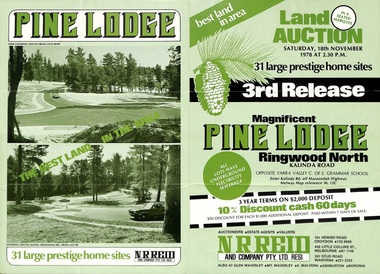 Ringwood and District Historical Society
Flyer, Land Auction Sale Brochure, Pine Lodge, Ringwood North, Victoria - 3rd Release 1978
Refer also to Reg. No. 5171 for Pine Lodge Land Auction previous release, 1977.Green tri-fold advertisement for auction of home sites, with map of subdivision, photographs, and summary of local features and services for Pine Lodge, Kalinda Road, Ringwood North - 3rd release - Auction date, Saturday, 18th November, 1978, at 2:30pm.Subdivision plan includes Mundara Drive, Bidston Court, Parkgate Drive, Frodsham Road, and Bebington Close. (Agent) N.R. Reid & Co. Pty. Ltd., 10A Hewish Road, Croydon (Phone) 725 0999, 450 Little Collins Street, Melbourne (Phone) 67 1746, and 207 Stud Road, Wantirna South (Phone) 221 2222. -
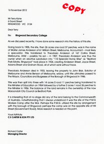 Ringwood and District Historical Society
Document - Folder, Brief history of the Ringwood Secondary College site in Bedford Road, Ringwood, Victoria, since 1905 and subdivision in 1924
Terry Kane and Richard Carter were the authors of the short historyType written notes and plans pertaining to the land titles and history of the Ringwood Secondary College site from 1905, prior to the land being sold by the Borough of Ringwood in 1954 to the Education Department. Transcript of covering letter from Richard Carter to Mr T Kane dated 16 November 2012 - "Re: Ringwood Secondary College As we discussed recently, I have done some research into the history of the site. Going back to 1905, the site, then 26 acres one rood 37 perches, was in the name of Walter James Anderson of 61 William Street, Melbourne, Accountant - most likely a speculator. Title transferred to Theodosia Anderson of 167 Collins Street, Melbourne, Artist - possibly his son - In 1907. Theodosia Anderson was thus the owner when on abortive subdivision Into "110 Splendid Home Sites" as "Bedford Park Estate, Ringwood" took place In 1924, creating Anderson Street, Joyce Street, Adams Street and Graham Road, all of which sank without trace. Theodosia Anderson died In 1933, leaving the property to John Blair, Solicitor of Melbourne and Annie Benson of Melbourne, widow, until title ultimately passed to The Mayor, Councillors and Burgesses of the Borough of Ringwood In 1946. Title was then spilt Into three with 14 acres 0 rood 11 perches being transferred to the Minister of Education on 1954 followed by a further 2 acres 1 rood 26 perches to the Minister In 1956. The balance of the land remains In the ownership of the now Maroondoh City Council as Bedford Park. It Is Interesting that at no stage did any of the land belong to the Commonwealth of Australia, notwithstanding that I always understood It was the site of the P.M.G. Workers Camp after the War. Perhaps the P.M.G. utilized the site by arrangement with the borough of Ringwood; perhaps the camp was on the opposite site of Hill Street (Government Road). More research Is needed on this point. Yours faithfully, CE CARTER & SON PTY LTD Richard Carter Managing Director" -
 Orbost & District Historical Society
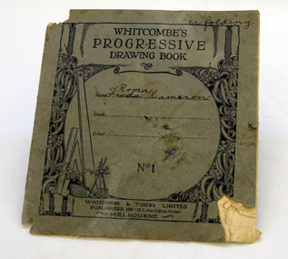
drawing book, Whitcombe's progressive Drawing Book No.1, 1920's
This book belonged to Roma Cameron. In the 1920's most of children's school work was done in copy books. Drawing as a subject generally began in Year 2. Each day's work was carefully dated and checked by the teacher, always ready for an inspector's visit. Roma Cameron was the daughter of Harry Purchase Cameron and Lilian Gladys (nee Harding). Roma married Ronald Richard Smith in 1944 and is the mother of Lorraine (Mrs Peter Coulton) and Margaret Smith. Harry's father, James Cameron, came to Bellagoogan on Majors Creek in 1882. Bellagoogan was on Majors Creek near Orbost and was the site of the first race course. Like many others at the time, the Camerons bred race horses.Harry died in 1964 aged 75. Roma was the youngest of three siblings: Jean (Mrs John Gavin (Jack) Ralston) and James (Jim) (m. Joan Hosack). This book is an example of school work in the early 20th century. The Cameron family are prominent members of the Orbost community. A small book with a grey cover. Inside are simple shapes to be copied.inside cover: Roma Cameron 1928education book-drawing cameron -
 Ringwood and District Historical Society
Photograph, Maroondah Highway West, Ringwood- c1920. Original Ringwood Market, Cnr. Maroondah Highway and Ringwood Street
Black and white photograph of wooden building. (2 copies)Typed under one copy: "Original Ringwood market and saleyards at corner of Maroondah Hwy and Ringwood St.. Charter St is beyond saleyards on right. SEC office now occupies site of buildings seen. c1920" Typed under second copy: "Original Ringwood market cnr Maroondah Highway and Ringwood St. opposite present clock tower site. 1920. Now SEC office. Sign on building reads- "Ringwood Market. D.G. McClelland & Co.. Stock Station Land Estate Agents. Alex McClelland, Auctioneer. -
 Ringwood and District Historical Society
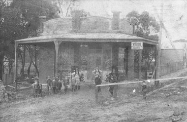
Photograph, Maroondah Highway East, Ringwood- 1914. Mr. O.J. Pratt's butcher shop under construction, cnr Main Street and Warrandyte Road
Black and white photograph (2 copies)Typed below photograph: "Mr. O.J. Pratt's butcher shop being constructed corner Warrandyte Rd. and Main St. (Demolished for road widening) 1914. Site became C.B.C. Bank. -
 Ringwood and District Historical Society
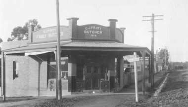
Photograph, Maroondah Highway East, Ringwood- 1920. Mr. O.J. Pratt's butcher shop, cnr Maroondah Highway and Warrandyte Road
Black and white photograph (2 copies)Typed below photograph, "Mr. O.J. Pratt's butcher shop north east corner Maroondah Highway and Warrandyte Rd. 1920. Site became C.B.A. Bank. -
 Ringwood and District Historical Society
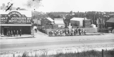
Photograph, Maroondah Highway East, Ringwood- 1920. H.J. Bently, Timber Merchant and Joinery
Black and white photograph (2 copies) Typed below one photograph: "Maroondah Highway 1920. Coffeys now on right and building on left still there (1979)" Written on rear of backing sheet: "Whitehorse Road 1920- Coffeys site- looking north. Shop now rebuilt and occupied by Lawford. Building behind 'H. J. Bentley' sign still there 1976 as part of Lawfords. Matlocks Livery Stables in background to left of 'Lime and Cement' sign. -
 Ringwood and District Historical Society
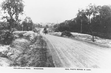
Photograph, Maroondah Highway East, Ringwood- c.1920. "Healesville Road, Ringwood" postcard featuring westward view along Whitehorse Road towards Mount Dandenong Road
4 photographs (2 large black and white, 2 small sepia postcard)Postcard labelled Healesville Road, Ringwood. Typed under large copy: "Looking down a dry Maroondah Highway from outside (eventual) Civic Centre site towards Mt. Dandenong Rd corner."