Showing 4572 items
matching park street
-
 Surrey Hills Historical Society Collection
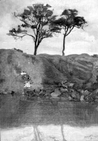
Painting, Muriel Pornitz (Pornett), "The old quarry" by Muriel Pornitz, 1927
The waterbody was the site of a quarry that existed between Grovedale Road and James Street, Surrey Hills on land owned by J B Maling (senior). Clay from it was used to make bricks for local houses. The quarry became a hazard and after several drownings was filled in. The Grovedale Park now occupies the site. Muriel Hedwig Lucy Pornitz, also known as Muriel Pornett, lived locally. She was born in Melbourne in 1894 and studied at the South Australian School of Arts & Crafts in 1911 under James Ashton and Fred Britton, and at the Australian School of Etching in Sydney. She was also an illustrator and cartoonist. She died in 1982.A small oil painting on canvas board in a dark wood frame of a water body with a clay bank behind and 2 trees above the bank. Lower front right hand corner: "AUST. M P 1927" On the rear upper edge, in ink on badly degraded brown paper backing: " "The Old Quarry" Surrey Hills, Melb." / [Second line of writing is illegible.] A label is stuck to the middle section of the paper backing. It indicates that the painting was framed by Toska Art Studio (N. Cl Colliver, Proprietor) of wyndham Street, Shepparton. Lower rear edge, in ink on badly degraded brown paper backing: "by / Muriel ...... / "Darnok", / 22 Grovedale Rd / Surrey Hills, Melb" painting, grovedale road quarry, quarry, grovedale road park, john butler maling (snr), surrey hills, muriel pornitz, muriel pornett -
 Surrey Hills Historical Society Collection
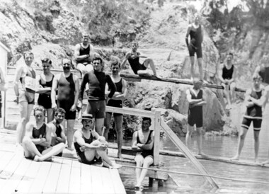
Photograph, The Surrey Dive c1909-1912
Located in Surrey Park, this photo was taken about 1909-1912. The Surrey Hills Swimming Club formed in 1906 and swimming carnivals were popular from this time. The dive was created from a clay hole formed during brick-making activity at the adjacent brick works. From 1906 Carnivals were popular events. Olympic competitors trained here until Councils built Olympic-sized pools. Photo by William V Hill of Pembroke Street. Donor Mr Bill Dempsey was his nephew.A black and white photograph of a group of 15 young men standing and sitting on diving boards and a platform near some stairs. Most are wearing long trunks covering their thighs and singlets. One person is wearing a boater hat.surrey dive, swimmers, bathing costumes, surrey hills swimming club, box hill brick works, festivals and celebrations, olympics, (mr) william v hill -
 Surrey Hills Historical Society Collection
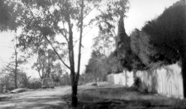
Photograph, Beatty Street, Mont Albert
The Lodewyckx family made their home at 3 Beatty Street, Mont Albert coming to the area after staying for six months at 'Medlow', the home of Dr Bull and his family while the latter were overseas. Augustin was in charge of the German Department at Melbourne University starting during the rather difficult days of the 1920s. A black and white photograph of a streetscape. There is a fence in front of a hedge along the right hand side of the photograph. There is a van parked on the left hand side of the photograph. There are many trees in the background.beatty street, mont albert, 1940-1949, lodewyckx family -
 Surrey Hills Historical Society Collection
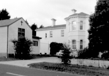
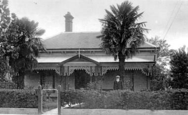
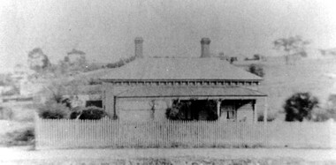
Photograph, Yielima, 31 Erasmus Street, Surrey Hills
Known as ‘Yielima’ 1888-1922 and ‘St. Aubins’ 1922-1956, this ‘modernized’ mansion was built about 1887 for Edward Kellett. He was born in Chorley, Lancashire, England. Edward Kellett married Selina Wells in 1852 at St Peters, Eastern Hill. She was born in c1827 in Aston Clinton, Buckinghamshire, daughter of William Wells and Elizabeth Allan. The family arrived from Aylesbury, Buckinghamshire on the 'Osprey' on 22 March 1849. The couple had 8 children - 5 girls and 3 boys; 3 died in infancy. All were born in Collingwood before the family came to Surrey Hills. Edward's funeral notice in The Argus of 11 July 1893 states that he was a corn merchant of Exhibition Street. His property was sworn at 1512 pounds, 1232 in realty and 280 pounds personally. He was buried in Melbourne General Cemetery (CofE Compartment K, No 306). Selina is listed in Erasmus Street in the 1903, 1905 and 1908 electoral rolls as a boarding house keeper. She died at Surrey Hills on 22/10/1911. In her will she left realty valued at 900 pounds and personally at 220 pounds. She was buried with her husband. 'Yielima' was sold on 19 Febraury 1919 with a sale of contents on 18 March 1919. From 1922-1947 Thomas Daniel O’Callaghan (c1871-1962), a police magistrate, made his home here. He is remembered as being of ‘soldierly demeanour, with a flowing mane of hair’. He always carried a walking stick and wore a flower in his buttonhole. His wife was Florence (nee Harling, c1873-1933) pre-deceased him. They had previously lived in Essendon, Moonee Ponds and Stawell before coming to Erasmus Street. After moving out of Erasmus Street he is listed in the 1949 and 1954 electoral rolls at 90 Durham Road, Surrey Hills. In 1952 the property was purchased by Father Timothy Fitzpatrick, Parish Priest of Our Holy Redeemer Parish, Surrey Hills. It consisted of a large two storey house, a coach house and stable, and an acre and a half of land. In 1954 the coach house and stable were converted into the Church of Our Lady of Perpetual Succour and the following year Father John Kelly was appointed parish priest. and resided in the house. At this time the house was not in good repair. "The gentleman who had lived there alone since his wife died many years before, lived in the servants quarters and the rest of the house had been badly neglected. (REF: https://ourholyredeemer.cam.org.au/history) At the beginning of 1957 the Missionary Sisters of the Sacred Heart opened a school next door. As they travelled from Balwyn on a daily basis, the property at 301 Elgar Road was purchased as a presbytery and 'Yielima' became a convent. The stables continued to be used as a church until 1964 when a new church was completed and opened by His Grace Archbishop Simmonds on the 20th of March. There were never large numbers of double-storey Victorian mansions in Surrey Hills. 'Yielma' is significant as one of the few remaining ones. It is also significant for its association with the Catholic Church.A black and white photograph of an Italianate style home with a weatherboard building with a cross on it in front of the main building and to the left of the photograph. There are some well established trees in the garden, a car parked in the parking area and a picket fence along the front.yielima, st aubins, house names, erasmus street, surrey hills, 1887, (mr) edward kellett, (mr) thomas daniel o'callaghan, corn merchant, police, italianate style, wattle park roman catholic church, (mrs) florence o'callaghan, mrs selina kellett, miss selina wells, convent, presbytery, our lady of perpetual succour -
 Surrey Hills Historical Society Collection
Photograph, Joe and Emily George of Scheele Street, Surrey Hills
Mrs Emily Ruth George of 26 Scheele Street, with husband, Joe. Emily & Joe were English migrants; they bought their home in 1919. Daughter Marie was born in 1914 when they are listed in the electoral roll at 'Hasland', Croydon Road, Surrey Hills; his occupation is given as a boilermaker. Emily (nee Sturgess) - d 15 November, 1960; buried Box Hill Cemetery - M-199A-0034 along with daughter Marie. Possible birth c Oct 1880, Birmingham (not confirmed); marriage c Jan 1905, Chesterfield, Derbyshire. Marie George became a school teacher and was on the staff at Chatham Primary School for a number of years. She died in February 1989. Mrs George was known for her hospitality. Anecdotes: On one occasion the government was to build six houses opposite in an area which was mostly paddocks. The materials were delivered and a caretaker allocated to guard them. He arrived with his wife to find a meagre tin shed as ‘home’. Mrs George responded by boarding the couple, for a very minimum amount for the six months. A rather different anecdote involves the droving of sheep from Lower Plenty across paddocks and tracks, through Doncaster and down Union Road to the station en route to the Richmond abattoirs. This was a seasonal activity and the men (and sheep) used to rest in the paddocks in Union Road, at the corner of Weybridge Street – behind the Georges’ home. When Mrs George heard the sheep, she would go out and fill the drovers’ billies with tea, handing out thick cheese sandwiches made from her homemade bread. A black and white photograph of a man and a lady dressed to go out and standing in the street. There is a car parked on the other side of the road in the background.(mrs) emily george, (mr) joe george, scheele street, surrey hills, mont albert, droving, clothing and dress, (miss) marie george, 'hasland', croydon road, (mrs) emily ruth george, (miss) emily ruth sturgess, box hill cemetery -
 Surrey Hills Historical Society Collection
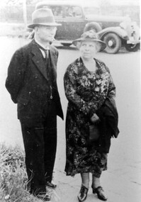
Photograph, Richard Bate at his home 'Camelford', 7 Norris Street, Surrey Hills (demolished)
Richard Bate built ‘Avondale’ at 176 Union Road in 1883 as a display home for subdividers of the Windsor Park Estate auction in that year. Richard built many homes in the locality – probably including No.101 Guildford Road, almost identical to his home. Richard also built the Box Hill Shire Hall in the 1880s (replaced in 1934 by the Box Hill Town Hall). Richard junior and family retained this house until the 1950s. Occupied in 2000 by Julie Ellis. In May 2000 Richard's grandson Jack Bate and great-grandsons Alan and Geoff (all of whom are builders) visited 7 Norris Street and lent this photo for copying. Demolished after subsequent sale. A black and white photograph of a Federation/Edwardian style timber house with detailed lacework around the veranda. There is a man standing on the right side of the photo. He is wearing a hat and is sporting a long white beard.norris street, surrey hills, house names, avondale, camelford, windsor park estate, box hill shire hall, builders, federation style, edwardian style, richard bate -
 Surrey Hills Historical Society Collection
Photograph, Entrance to Wattle Park from Riversdale Road, 1912-1914
Information provided by Stan Smith: Riversdale Road looking east 1912-1914. Wattle Park, then a farm is on the right. The near row of trees across the picture, indicates the driveway in Wattle Park. Wattle Park was then Fenwick's farm - or - Fennies to the local boys. Note: Riversdale Road becomes not much more than a track after passing the farm entrance.A dirt road in the lower left corner of the photograph is bounded by a post and rail fence. Two cyclists are on the road. "Wattle Park" is written to the right side of the road.wattle park, 1912, farms, 1914, fenwicks farm, fennies, fences, trees, roads and streets, riversdale road, pine trees, gum trees, cyclists -
 Surrey Hills Historical Society Collection
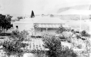
Photograph, Back Creek (later South Surrey Park), c 1936, 1936
This photo was taken at the opening of the footbridge by Sir Winston Dugan in 1936.South Surrey Park was developed on land which had been the property of the Kleinert family. Their land extended from Union Road to Essex Road. They ran horses, ducks and fowls and Emily Kleinert grew flowers. Alan Holt research: Lot 6 was sold to Martin Klienert by Karl Richter in 1860 together with a portion of another adjacent lot. From 1860-1885 Martin worked it as a market garden leasing some land for grazing when it was not required for gardening. He died in 1898. In a formal document, William declared he was the son of Martin "who purchased land in 1860, died in 1898 and the land has been continually occupied by father and family since. It has been cultivated as a market garden; when not being used for gardening it was let for cultivation and grazing." William died in 1939 and the property passed to his sons Martin and Ernest. The family sold the land to the Camberwell Council in the 1950s.This photo is significant as it shows the transition from rural to urban land use in Surrey Hills.Black and white photo taken in the area later known as South Surrey Park. Back Creek is in the foreground. There is a tent on the LHS and approximately 7 houses which front Verdun Street. Some of their backyards face onto the open space along the creek bed.parks and reserves, creeks, south surrey park, civic occasion, official events, back creek, verdun street, 1936, kleinert family, sir winston dugan, topography -
 Surrey Hills Historical Society Collection
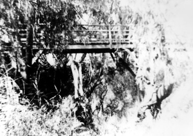
Photograph, Footbridge across Back Creek, 1980, 1980
... and reserves creeks south surrey park back creek verdun street ...South Surrey Park was developed on land which had been the property of the Kleinert family. Their land extended from Union Road to Essex Road. They ran horses, ducks and fowls and Emily Kleinert grew flowers. Alan Holt research: Lot 6 was sold to Martin Klienert by Karl Richter in 1860 together with a portion of another adjacent lot. From 1860-1885 Martin worked it as a market garden leasing some land for grazing when it was not required for gardening. He died in 1898. In a formal document, William declared he was the son of Martin "who purchased land in 1860, died in 1898 and the land has been continually occupied by father and family since. It has been cultivated as a market garden; when not being used for gardening it was let for cultivation and grazing." William died in 1939 and the property passed to his sons Martin and Ernest. The family sold the land to the Camberwell Council in the 1950s. The original footbridge was opened by Sir Winston Dugan in 1936.Black and white photo of a wooden footbridge with large trees and shrubs obscuring its surrounds.parks and reserves, creeks, south surrey park, back creek, verdun street, footbridges -
 Surrey Hills Historical Society Collection
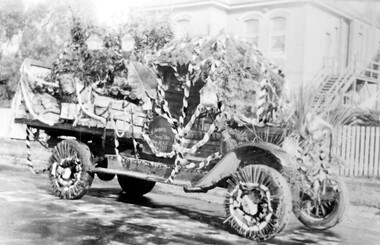
Photograph, Armitstead Woodyard truck decorated for Empire Day, mid-1930s, 1930
Date is approximate. Donor's connection with Armitstead's Woodyard was that Frank Foley was a long term employee. The Empire Day movement was instituted in England in 1904 and on 24 May 1906 a group of Surrey Hills residents pledged to make Empire Day a success. From 1932-1938 large Empire Day celebrations were held in Surrey Hills and business and commercial vehicles were decorated to take part in large processions held in May each year. These attracted large crowds from all over Melbourne. The truck is parked outside Nethercourt Hospital at 15 Barton Street. The Armitstead family had a business in Union Road which supplied wood in winter and ice in summer. Photos such as this one are evidence of the importance once attached to celebrating Empire Day, which was held on 24 May (Queen Victoria’s birthday). From 1905, a range of patriotic activities across Australia were performed on this day. There was a focus on schoolchildren, who were given a half-holiday, and the occasion was often highlighted with bonfires and fireworks in the evening - in this area at Beckett Park. The parade down Union Road was famous throughout Melbourne and attracted large crowds. Floats in the parade were often decked with British flags. The pro-Empire sentiment in the Surrey Hills area in part reflected the background and strong ties of many families.Black and white photo of a delivery truck with bunting and ferns over the cabin and back. The wheels have straws around the rims and more foliage is on the cabin roof and bonnet. The back of the tray is up and boxes, foliage and possibly a lion's head decorate the tray. Behind is a 2 storey (?) rendered building with an external timber staircase broken in 2 by a landing. The house sits behind a simple picket fence.On the cabin door of the truck: "S ARMITS ....[remainder in shadow] / Surrey Hills / phone 10X1816 / [undecipherable]" On back of the original in pencil in top centre left "446a" in Jocelyn Hall's handwriting; centre on a piece of paper stuck on with tape "Mrs D Foley / 39 Sunbury Cres., / Surrey Hills / Phone 8301163".empire day, festival and celebrations, woodyard, parades, processions, hospitals, nethercourt hospital, stephen godfrey armitstead, frank foley, mrs d foley, barton street -
 Surrey Hills Historical Society Collection
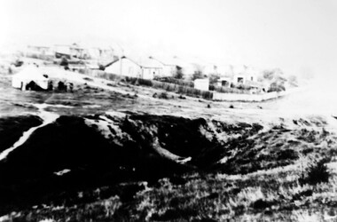
Photograph, Grovedale Road Quarry in the 1920s - looking south, c1920
The quarry was part of John Butler Maling's property. He was one of the original settlers of the area and farmed the area between Weybridge Street and Whitehorse Road. Clay was quarried from part of this area and used to make the bricks used in the construction of his home, known as 'Ancyra'. This is still extant at the corner of Weybridge and James Streets. Maling grazed cows and used the quarry as a water source. He was the uncle of John Butler Maling, Mayor of Camberwell. He was married to Kate Conlon in 1882. They had 3 children: Silas Young, Alick and Zillah. Maling was born in c1829 in Shepreth, Cambridgeshire; he died in Surrey Hills on 9 October 1912 and is buried in Box Hill Cemetery - CE-*-0586. Mrs Kate Maling (born c1859 in Co Meath, Ireland) died at the property on 8 March 1921. She is buried in Brighton General Cemetery. Probate was valued at over 10,000 pounds and included other properties in Sandringham, Hawthorn and Macedon. At the time of her death the Surrey Hills property was described as being 23 acres with 2 brick houses, 1 cow, 2 heifers and 40 fowls or chickens. The property was subdivided after her death. The property was subdivided into 110 house blocks in c1923 - see Maling's Estate subdivision flyer on the State Library of Victoria's website. This shows that the Grovedale Park site had been acquired by Camberwell Council by this time. An attached newspaper clipping documents prices realised for a cross-section of blocks. The MMBW map of 1925, also on the SLV website, shows the outline of the clayhole / quarry. The quarry was filled in after several drownings or near drownings and the land is now occupied by a park and playground, known as Grovedale Road Park, maintained by the City of Boroondara. Beckett Park is sited on horizon to the left beyond the trees. This documents the landscape prior to close settlement and is material to early building and farming in the Surrey Hills area.Black and white photo of the quarry between Grovedale Road and James Street taken in the 1920s and looking south. In the foreground is an area of water with reeds in the LH corner. Beyond on the high banks there are single storey houses in the background and (?) some light poles. An object that looks like a tank on posts is in a cutting on the far bank.quarries, grovedale road, james street, clay quarries, farming, kate conlon, kate maling, john butler maling, ancyra -
 Surrey Hills Historical Society Collection
Photograph, Grovedale Road Quarry in the 1920s - looking north, c1920
The quarry was part of John Butler Maling's property. He was one of the original settlers of the area and farmed the area between Weybridge Street and Whitehorse Road. Clay was quarried from part of this area and used to make the bricks used in the construction of his home, known as 'Ancyra'. This is still extant at the corner of Weybridge and James Streets. Maling grazed cows and used the quarry as a water source. He was the uncle of John Butler Maling, Mayor of Camberwell. He was married to Kate Conlon in 1882. They had 3 children: Silas Young, Alick and Zillah. Maling was born in c1829 in Shepreth, Cambridgeshire; he died in Surrey Hills on 9 October 1912 and is buried in Box Hill Cemetery - CE-*-0586. Mrs Kate Maling (born c1859 in Co Meath, Ireland) died at the property on 8 March 1921. She is buried in Brighton General Cemetery. Probate was valued at over 10,000 pounds and included other properties in Sandringham, Hawthorn and Macedon. At the time of her death the Surrey Hills property was described as being 23 cres with 2 brick houses, 1 cow, 2 heifers and 40 fowls or chickens. The property was subdivided after her death. The quarry was filled in after several drownings or near drownings and the land is now occupied by a park and playground maintained by the City of Boroondara. Beckett Park is sited on horizon to the left beyond the trees. This documents the landscape prior to close settlement and is material to early building and farming in the Surrey Hills area.Black and white photo of the quarry between Grovedale Road and James Street taken in the 1920s and looking north. In the foreground is an area of water with high banks dividing the horizontal centre. Beyond are paddocks and trees behind which is a row of at least 3 single-storey houses. Light poles can be seen along a distant street. There are many mature trees in the background. The houses and trees are positioned along Whitehorse Road in the vicinity of Westminster Street. Shadows indicate the photo was taken in early morning or evening.quarries, grovedale road, james street, surrey hills, balwyn, clay quarries, ancyra, kate conlon, kate maling, john butler maling, farming -
 Surrey Hills Historical Society Collection
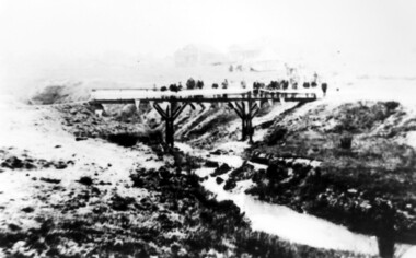
Photograph, Opening of the footbridge across Back Creek, 1936, 1936
This photo was taken at the opening of the footbridge over Back Creek by Sir Winston Dugan, Governor of Victoria, in 1936. He is cutting bunting draped along the bridge rails. South Surrey Park was developed on land which had been the property of the Kleinert family. Their land extended from Union Road to Essex Road. They ran horses, ducks and fowls and Emily Kleinert grew flowers. Alan Holt research: Lot 6 was sold to Martin Klienert by Karl Richter in 1860 together with a portion of another adjacent lot. From 1860-1885 Martin worked it as a market garden leasing some land for grazing when it was not required for gardening. He died in 1898. In a formal document, William declared he was the son of Martin "who purchased land in 1860, died in 1898 and the land has been continually occupied by father and family since. It has been cultivated as a market garden; when not being used for gardening it was let for cultivation and grazing." William died in 1939 and the property passed to his sons Martin and Ernest. The family sold the land to the Camberwell Council in the 1950s.This photo is significant as it documents the change from rural to urban land use in the area.Black and white photo taken at the opening of the footbridge across Back Creek in the area later known as South Surrey Park. Back Creek runs diagonally through the photo with a wooden footbridge prominent. Dignitaries are gathered on the bridge. A tent and houses can just be distinguished in the background.parks and reserves, creeks, south surrey park, civic occasion, official events, back creek, verdun street, footbridges, governor of victoria, sir winston duggan, surrey hills, kleinert family, (mr) karl richter, (mr) martin kleinert, topography -
 Surrey Hills Historical Society Collection
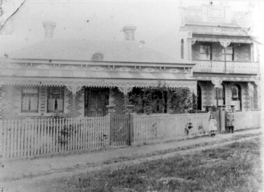
Photograph, 34 Union Road, Surrey Hills - home of the Kleinert family
This was built in 1905 and was the home of William and Emily Kleinert from 1905. William was a coach-builder, wheelwright and blacksmith. He moved from Prahran to Surrey Hills. His son Ernest worked with him as a coach painter and also worked as a painter undertaking intricate hand painting on early cars. Their other son Martin played for the Surrey Hills Football Club. In return for the support given to the club by Mrs Emily Kleinert, the club built a rotunda in South Surrey Park as a memorial to her. Alan Holt research: Lot 6 was sold to Martin Kleinert by Karl Richter in 1860 together with a portion of another adjacent lot. From 1860-1885 Martin worked it as a market garden leasing some land for grazing when it was not required for gardening. He died in 1898. In a formal document, William declared he was the son of Martin "who purchased land in 1860, died in 1898 and the land has been continually occupied by father and family since. It has been cultivated as a market garden; when not being used for gardening it was let for cultivation and grazing." William died in 1939 and the property passed to his sons Martin and Ernest. The Kleinert land extended from Union Road to Essex Road. They ran horses, ducks and fowls and Emily Kleinert grew flowers. The Kleinert property later became the South Surrey Park. The family sold the land to the Camberwell Council in the 1950s. Ernest and Ida Kleinert lived on the corner of Scotsdale and Warrigal Roads. The donor of the photo Nada Harris, nee Kleinert, was Ernest and Ida's daughter. Ida lived to a good age (> 93 years) and in later life lived in Burwood.Black and white photo of a Victorian cottage with a typical bull-nosed veranda. It is set behind a wooden picket fence with undeveloped grazing land studded with mature trees in the background. Taken front-on from the street. There appears to be a path but no formal curb to the road.south surrey park, union road, surrey hills football club, blacksmiths, wheelwrights, coachbuilders, rotunda, miss nada kleinert, mr william kleinert, mrs emily kleinert, mr martin kleinert, mr ernest kleinert, mr karl richter, mrs ida de vasy, mrs nada harris -
 Surrey Hills Historical Society Collection
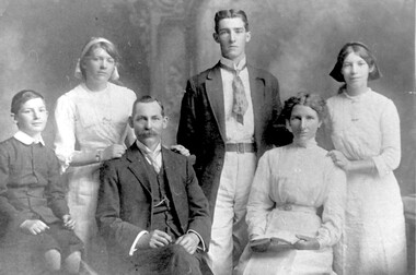
Photograph, Formal photo of the Kleinert family of 34 Union Road, Surrey Hills
William was a coach-builder, wheelwright and blacksmith. He moved from Prahran (13 Regent Street) to Surrey Hills to property owned by the family. The house at 34 Union Road was built in 1905 for William and his wife Emily. Their son Ernest worked with him as a coach painter and also worked as a painter undertaking intricate hand painting on early cars. Their other son Martin played for the Surrey Hills Football Club. In return for the support given to the club by Mrs Emily Kleinert, it built a rotunda in South Surrey Park as a memorial to her. Alan Holt research: Lot 6 was sold to Martin Kleinert by Karl Richter in 1860 together with a portion of another adjacent lot. From 1860-1885 Martin worked it as a market garden leasing some land for grazing when it was not required for gardening. He died in 1898. In a formal document, William declared he was the son of Martin "who purchased land in 1860, died in 1898 and the land has been continually occupied by father and family since. It has been cultivated as a market garden; when not being used for gardening it was let for cultivation and grazing." William died in 1939 and the property passed to his sons Martin and Ernest. The Kleinert land extended from Union Road to Essex Road. They ran horses, ducks and fowls and Emily Kleinert grew flowers. The Kleinert property later became the South Surrey Park. The family sold the land to the Camberwell Council in the 1950s. Ernest and Ida Kleinert lived on the corner of Scotsdale and Warrigal Roads. The donor of the photo Nada Harris, nee Kleinert, was Ernest and Ida's daughter. Ida lived to a good age (> 93 years) and in later life lived in Burwood. Many of the family are buried in Box Hill Cemetery. Friedrich Johann Wilhelm (William) Kleinert (1870-1949) married (1872-1937) in 1893. Their children were: Ernest Henry John (1892-1971) married Ida Grace Vassie. Ivy Louise (1898-1952) Martin William (1903-1964) Henriette Rose (Hetta Rose) 1896-1958.Black and white photo of William and Emily Kleinert and family. The children are L to R: Martin, Rose, Ernest and Ivy.surrey hills football club, blacksmiths, wheelwrights, coachbuilders, south surrey park, rotunda, friedrich johann wilhelm kleinert, william kleinert, emily florence radford, emily florence kleinert, ernest henry john kleinert, ida grace vassie, ida grace kleinert, ivy louise kleinert, martin william kleinert, henriette rose kleinert, hetta rose kleinert, rose kleinert, nada harris, nada kleinert -
 Surrey Hills Historical Society Collection
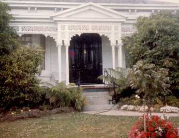
Photograph, 101 Guildford Road, Surrey Hills
The house was built in 1883, possibly to encourage development of housing on the first urban land subdivision in Surrey Hills, the Windsor Park Estate (in the Windsor Crescent area). This coincided with the opening of the Surrey Hills Railway station. The first occupant was John Brown Nicholson, police magistrate. In 1884 the foundation meeting of the Wyclif Congregational Church was held in the house.Colour photo of the front door and verandah of 101 Guildford Road taken from the street. The house is Victorian in style with ornate lacework along the verandah. It is painted white and has a slate roof. There is a well-maintained garden with flower beds and shrubs, which partially obscure the house.victorian style, wyclif church, houses, guildford road, john brown nicholson -
 Surrey Hills Historical Society Collection
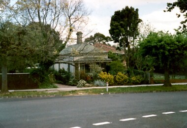
Photograph, 'Glenisla', 18 Chestnut Street, Surrey Hills, c 1920, 1920
Date is approximate. In 1920 this became the home of Mr and Mrs Robert Moore, whose daughter Mabel Annie married Norman Brodley Carter of Mont Albert. The house was named after 'Glenisla', a western District grazing property located between Hamilton and Horsham on the Henty Highway and on the edge of the Grampians National Park. This was established as a super-fine wool stud in 1860 and was passed down the family until it was sold in 1922. The family transferred from this property to Melbourne. Robert is listed as a grazier in the 1924 electoral roll at Chestnut Street. With him are Victor Cecil listed as a carpenter; Isabella, Mabel Annie and Edgar Gilbert listed as an orchardist. In 2003 the house was extant minus the verandas. This photo may have been taken from the rear of the property. Ref: History of original property - Age newspaper article: 'The Best - Glenisla: historic Grampians property', 7 January 1994. Moore family details: Robert Moore born 1857 on Isle of Man; died Surrey Hills 1940 Isabella Bateson born 1869; died Surrey Hills 1938 Married in 1894 in Miram, 10 km north-east of Kaniva in the northern Wimmera. All the children were born in Kaniva. Children: Lena Florence (1895-1980) Victor Cecil (1896-1984) - a builder Edgar Gilbert (1897-1976); died Surrey Hills; married Myrtle Emary, daughter of Henry John Emary of Surrey Hills Ernest Alan (1900-1900) Mabel Annie (1901-1957); died Surrey Hills married Norman Brodley Carter (1899-1984) Clarence Arthur (1904-2004). Norman Carter took many photos in the Surrey Hills and Mont Albert are from the 1920s; many is connection with Church of England events and activities. Robert and Isabella Moore are buried in Box Hill Cemetery. Black and white photo of a Victorian home with a veranda with a corrugated iron roof and lacework on 2 sides. It appears to have a later extension at the rear. It is surrounded by mature gardens with ornamental trees (cypresses) and an area with plants in rows, which may be a vegetable garden. There appears to be significant areas of open space around the house.glenisla, homes, victorian style, gardens, norman carter, robert moore, miss isabella bateson, mrs isabella moore, victor cecil moore, edgar gilbert moore, miss mabel annie moore, box hill cemetery -
 Surrey Hills Historical Society Collection
Photograph, 'Maitland', 1 Bedford Avenue, Surrey Hills, c 1900, 1900
Maitland' was built in 1889 for Thomas Zeplin, who was a Professor of Music. He owned all the land bound by Union Road, Wilson and Montrose Streets and the railway line. 1 Bedford Avenue stayed in family ownership until purchased by Camberwell Council in 1986, initially for a car park. However it was renovated to become part of Surrey Hills Neighbourhood Centre. It was opened on 23 November 1990. No 3 Bedford Avenue was built for Thomas Zeplin's daughter and named 'Mervyl' or 'Merryl'. Mrs Brodecky (donor) was the great-granddaughter of Thomas Zeplin. The 2 girls are granddaughters of Thomas Zeplin. Electoral roll information: 1972 & 1977: Albert Vojteck Brodecky, manager, 1 Bedford Avenue. 1977: Ray Nanette Brodecky. There are 2 copies. Thomas had this built for his son and family. The house was occupied by his family, though sometimes rented out. His great-grand-daughter Mrs. A. Brodecky sold to the Camberwell Council in 1986. This was the only surviving photo in the family after the fire. Courtesy: Mrs. A. BrodeckyBlack and white photo of 2 houses taken from the street front. On the LHS is a Victorian double-fronted single-storey villa of Hawthorn brick construction, with wrought iron lacework to the veranda, slate roof and picket fence, with an established garden. Next door at No 3 is a double-storey Victorian terrace with a similar fence and building materials. There are 2 young girls standing in front between the properties.maitland, bedford avenue, 1900, surrey hills neighbourhood centre, victorian style, mervyl, merryl, mr thomas zeplin, mrs nanette brodecky, mr albert vojteck brodecky -
 Surrey Hills Historical Society Collection
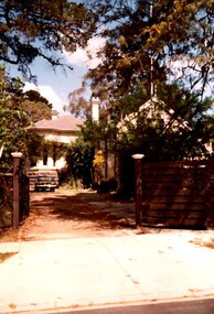
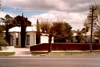
Photograph, Rear of Varndean from Willcyrus Street, 1988, 1988
Ref: Alan Holt records - This property has had a number of different names throughout its history. William Cook, a farmer, bought the land it stands on in 1876. In 1882 he was rated for a house (not the current one) on 11 acres. The present house was built in 1885 by John Clark, an auctioneer. In 1888 the Tower Hill estate and the home (Tower Hill Lodge) were auctioned, but the house was not sold. In 1889 the house was purchased by Captain Shepherd. Records show that in 1894 the owners were Mr Thomas and Mrs Hortenzia Howell. They named the house 'Corcovado'. Later they added a study with a corner designed to provide views from the Dandenong Ranges around to Mt Macedon. In 1944 Mr and Mrs Lionel Adams renamed the house 'Varndean'.This is one of the earliest surviving houses in Surrey Hills.A colour photo taken from the street at the rear of a Victorian-style house with ornate chimneys and a slate roof. A parked car is seen in front of the house. The house sits behind a timber fence and is partly hidden by mature shrubs and trees.victorian style, tower hill lodge, corcovado, varndean, tower hill estate, mr william cook, mr john clark, mrs hortenzia howell, mr lionel adams, mrs lionel adams, surrey hills, captain louis shepherd, mr thomas howell -
 Surrey Hills Historical Society Collection
Photograph, Merthyr - 64 Windsor Crescent, Surrey Hills, 1988, 1988
Ref: Alan Holt records - This property was part of Lot 25 in the Windsor Park Estate which was subdivided in 1883. The house of 12 squares was built in 1888 for John Abernethy, an engineer. He also built 62 Windsor Crescent as a coachhouse and cottage. 1888-1891: Owners = John & Sarah Abernethy. John Abernethy died while on a trip to Hong Kong in 1891. 1891-1909: Owner = Mrs Sarah Abernethy 1910-1917: Owner = H Jenkinson The properties at 62 and 64 Windsor Crescent were separated during WW1 (by H Jenkinson). See Alan Holt records for other short term owners. 1970-1975 = Plymouth Bretheren Meeting Hall In 1976 it became a private home again.This is one of the earliest surviving houses in Surrey Hills.A colour photo taken from the street at the rear of a Victorian-style house with rendered walls and a slate roof. The house sits behind a timber fence.victorian style, windsor park estate, merthyr, plymouth bretheren meeting hall, mr john abernethy, mrs sarah abernethy, mr h jenkinson, surrey hills -
 Surrey Hills Historical Society Collection
Photograph, 62 Windsor Crescent, Surrey Hills, 1988, 1988
Ref: Alan Holt records - This property was part of Lot 25 in the Windsor Park Estate which was subdivided in 1883. A house of 12 squares was built in 1888 at 64 Windsor Crescent for John Abernethy, an engineer. The property at 62 Windsor Crescent was built as a cottage and coachhouse associated with the main house at 64 Windsor Crescent. 1888-1891: Owners = John & Sarah Abernethy. John Abernethy died while on a trip to Hong Kong in 1891. 1891-1895: Owner = James Gibbon 1896-1897: Owner = John Steele See Alan Holt records for other short term owners. The properties at 62 and 64 Windsor Crescent were separated during WW1(by H Jenkinson). 1914-1923: Owner = Miss Dulcie Burchett, music teacher 1930-1953: Owner = William Langley & family.A colour photo taken from the street of a simple timber cottage with a brick chimney and green corrugated iron on the roof and verandah. The house has no front fence and is partly obscured by garden shrubs.victorian style, windsor park estate, cottages, timber houses, mr john abernethy, mrs sarah abernethy, mr james gibbon, mr john steele, miss dulcie burchett, mr william langley, surrey hills -
 Surrey Hills Historical Society Collection
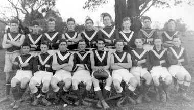
Photograph, Surrey Hills Wanderers football team, 1920
Date is approximate. Identified as: Front row (L to R): Frank Peirce, Mac Burns, ......., Charles Smith, Bert Butler, ....., ......, Bill Little. Back row (L to R): ...., Leo Armitstead, Jim Sneddon, .......................... - Burton. Frank Peirce transferred to Carnegie. Charles Smith was the son of the newsagent. Mac Burns lived in Russell Street. Bert Butler lived in Wandsworth Road. - Burton became Secretary of the Lord Mayor's Fund. The Surrey Hills Wanderers became the Surrey Hills Junior Football Club. This photo was copied for Geoff Armitstead in November 2002. Recorded on the mount in Jocelyn Hall's writing that there is also an original of this photo. ["107 Neg & print & original"]Black and white photo of a 1920s team of the Surrey Hills Wanderers football club. Eighteen players are dressed in white shorts and dark jumpers with a light V marking. The setting is outdoors, possibly in Surrey Park where the team played. surrey hills wanderers, football, sport, surrey hills junior football club, surrey park, geoff armitstead, frank pierce, charles smith, mac burns, bert butler, bill little, leo armitstead, jim sneddon, mr - burton, glen armitstead, alan sneddon -
 Surrey Hills Historical Society Collection
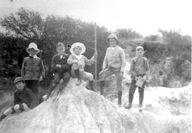
Photograph, Boys who later joined the 1st Surrey Hills scout troop, 1909
1st Surrey Hills was the 3rd troop formed in Victoria. Harrison Buchanan was not old enough to join and for a time was the 'troop mascot' as the cubs had not been formed at this time. He later became the troop's 2nd Scoutmaster. Doug Jeffries lived at 12 Vincent Street. Alex Lucas was the son of the draper in Canterbury Road. Our documentation variously gives the date as 1901 or 1909.Six boys are pictured against a backdrop of scrub in the eroded creek bed, called 'The Alps', of Back Creek opposite Wattle Park. Three of them are identified as: Harrison Buchanan (with the stave), Doug Jeffries on the LHS and Alex Lucas next to him.Black and white photo measuring L 24.5 cm x H 17.4 cmback creek, 1st surrey hills scout troop, scouts, harrison buchanan, alex lucas, doug jeffries, childhood and youth, topography -
 Surrey Hills Historical Society Collection
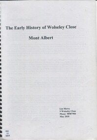
Book, The early history of Wolseley Close, Mont Albert, 2010
... ) william henry cleverdon wolseley street windsor park estate ...Includes copy of will of William Clark. Resident of the property at 9 Wolseley Close in 1910. Includes copy of the Alan Holts home occupier / tenant records - names from 1920 - 1980. Includes photo of Wolseley Close house, taken 1888/1889 plus colour photo of Wolseley Close house taken by Lin Merry, 2010. Land Title information, surveys, subdivision Includes list of occupants of the house, p.17Includes some plans of houses built in Wolseley Close, Mont Albert, Victoria. Outlines details of property at 9 Wolseley Close19p : col illcragg family, windsor crescent, surrey hills, (mr) william ainger, (mr) isaiah ainger, whitehorse road, noorn hill, house names, koonda, d j maloney, (mrs) louisa clara maggs, taramera, union road, st.abbs, york street, (mr) william henry cleverdon, wolseley street, windsor park estate, tarawera, merry family, clinton family, adams family, tel-el-kebir, farrell family, (mr) william clark, trafalgar street, (mr) (sir) matthew davies, (mr) c h james, (mr) james munro, (mrs) elizabeth clark, langdale, (mr) stanley dewar, (mr) john jose, (mrs) emily hampton, potton, (mr) alexander potton, (mr) john atkinson morris, freehold investment & banking co., mont albert, windsor park surrey hills, dalton family, (mr) henry wood, wolsley close -
 Brighton Historical Society
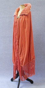
Cape, Opera cape, circa late 1920s
This velvet opera cape was worn by Agnes Emmeline "Dot" McCowan (nee Iredell, 1887-1969) to a reception for English aviatrix Amy Johnson in her North Road home in the early 1930s. Amy Johnson achieved worldwide fame in 1930 when she became the first woman to fly solo from England to Australia. Dot was the fourth child, and only surviving daughter, of Dr Charles Lesingham Maynard Iredell and Frances Keziah Iredell (née Hill), both formerly of Regents Park, London. Her parents had arrived in Australia in 1885 after Charles, a medical specialist, lost his money and house in the financial crash of 1880. In Melbourne, Charles established a reputation as an ear, nose and throat specialist and counted Dame Nellie Melba among his patients. Dot was schooled at Fairlight College in St Kilda. After falling from a tree at the age of twelve, she developed curvature of the spine. While recuperating, she took a correspondence course in theory and harmony of music with the Royal College of Music, London. She continued to pursue music after her recovery, ultimately winning an international scholarship to study piano and singing in Leipzig, Germany, but did not take up the offer due to her father's objections. She instead remained in Melbourne, where she put her skills to use as a music teacher. After her first fiancé disappeared at sea, Dot found happiness again with George Drummond. George owned a substantial property in Manjimup, Western Australia, and the couple planned to settle there after the wedding. It was not to be. Like many Australian men, George was killed in action on the Western Front during the First World War. It had become customary in George's wealthy family to give each son's bride a gift of one thousand pounds. Though Dot and George were never able to marry, the family nevertheless honoured the custom, and between their generous financial gift and her own teaching income, Dot was able to buy a well-appointed home at 9 North Road, Brighton for herself and her parents. The house remained in the family for many decades. In 1923, at the age of thirty-six, Dot met and fell in love with Alexander James McCowan. They were married on 28 February 1924; the reception was held in the North Road house.Salmon pink velvet opera cape with a padded collar and long fringe. Fastens at collar with a pair of circular metal clasps engraved with floral designs and accentuated with purple enamel. Silk lining.agnes emmeline iredell, agnes emmeline mccowan, opera cape, 1920s, 1930s, amy johnson -
 National Wool Museum
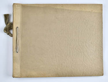
Album - Photo Album, 1 of 3, J W Allen, 1928-1929
This album is one of three albums compiled and owned by J W Allen, Secretary of New South Wales Grazier's, and is associated with the New South Wales Graziers Association world tour of sheep 1928-1929. This album contains photographs of travel, sheep, farms, stations, people and landscapes from around the world. Locations include Naples, Port Said, Suez, Birregurra (Vic), Alexandra (Vic), Ballangeich (Vic), Keith (SA), Mt Gambier (SA), Buckland Park (SA), Tasmania, Winton (QLD), Sydney Harbour, Canberra (ACT), Toowoomba (QLD), Rockhampton (QLD), Tocal (NSW), Deepwater (NSW), Glen Innes (NSW), Longreach (QLD), Moree (NSW), Barraba (NSW) and Mudgee (NSW). Properties depicted include Mooleric, Turkeith, Woolongoon, Minadale, Crower Station, Merrindie, Koomooloo Station, Cappeedee, Koonoona, Rathmore, Ellenthorpe, Camden Park Station, Glenlegh, Strathmore Station, Ilparran Station, Binneguy, Midkin, Terlings, Ashley, Bereen, Plumthorpe, Mayvale and Havilah. The album was found in a clean out at the Great Southern Agricultural Research Institute and donated to the National Wool Museum, along with other related material such as photographs, glass lantern slides and ephemera.Photo album with card cover and silk string binding. Inside are twenty four pages of brown carded paper with black and white photos and hand written black text. A white piece of paper with hand written text has been added to the inside front page.new south wales graziers association, world tour, sheep, farm, rural, agriculture, stations, mooleric, turkeith, woolongoon, minadale, crower, merrindie, koomooloo, cappeedee, koonoona, rathmore, ellenthorpe, camden park, glenlegh, strathmore, ilparran, binneguy, midkin, terlings, ashley, bereen, plumthorpe, mayvale, havilah, naples, port said, suez, birregurra, alexandra, ballangeich, keith, mt gambier, buckland park, tasmania, winton, sydney, canberra, toowoomba, rockhampton, tocal, deepwater, glen innes, longreach, moree, barraba, mudgee, merino -
 National Wool Museum
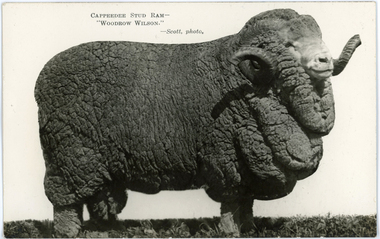
Postcard - 'Woodrow Wilson', Capeedee Stud Ram, Chas P Scott, 1926
This postcard was found loose in the first of three albums compiled and owned by J W Allen, Secretary of New South Wales Grazier's, and is associated with the New South Wales Graziers Association world tour of sheep 1928-1929. The album contains photographs of travel, sheep, farms, stations, people and landscapes from around the world. Locations include Naples, Port Said, Suez, Birregurra (Vic), Alexandra (Vic), Ballangeich (Vic), Keith (SA), Mt Gambier (SA), Buckland Park (SA), Tasmania, Winton (QLD), Sydney Harbour, Canberra (ACT), Toowoomba (QLD), Rockhampton (QLD), Tocal (NSW), Deepwater (NSW), Glen Innes (NSW), Longreach (QLD), Moree (NSW), Barraba (NSW) and Mudgee (NSW). Properties depicted include Mooleric, Turkeith, Woolongoon, Minadale, Crower Station, Merrindie, Koomooloo Station, Cappeedee, Koonoona, Rathmore, Ellenthorpe, Camden Park Station, Glenlegh, Strathmore Station, Ilparran Station, Binneguy, Midkin, Terlings, Ashley, Bereen, Plumthorpe, Mayvale and Havilah. The album was found in a clean out at the Great Southern Agricultural Research Institute and donated to the National Wool Museum, along with other related material such as photographs, glass lantern slides and ephemera.Photographic postcard with black and white image of a ram with white background, and black printed text.Front: CAPPEEDEE STUD RAM - / “WOODROW WILSON” / - Scott, photo Back: POST CARD / CORRESPONDENCE / ADDRESS ONLY / KODAK / AUSTRALIA / KODAK / AUSTRALIA / 16world tour, sheep, graziers, photograph, agriculture, capeedee, rams, stud, south australia, hallett, walter s murray -
 National Wool Museum
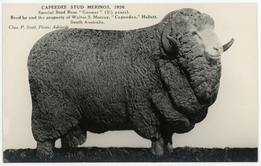
Postcard - 'Gunner', Capeedee Stud Ram, Chas P Scott, 1926
This postcard was found loose in the first of three albums compiled and owned by J W Allen, Secretary of New South Wales Grazier's, and is associated with the New South Wales Graziers Association world tour of sheep 1928-1929. The album contains photographs of travel, sheep, farms, stations, people and landscapes from around the world. Locations include Naples, Port Said, Suez, Birregurra (Vic), Alexandra (Vic), Ballangeich (Vic), Keith (SA), Mt Gambier (SA), Buckland Park (SA), Tasmania, Winton (QLD), Sydney Harbour, Canberra (ACT), Toowoomba (QLD), Rockhampton (QLD), Tocal (NSW), Deepwater (NSW), Glen Innes (NSW), Longreach (QLD), Moree (NSW), Barraba (NSW) and Mudgee (NSW). Properties depicted include Mooleric, Turkeith, Woolongoon, Minadale, Crower Station, Merrindie, Koomooloo Station, Cappeedee, Koonoona, Rathmore, Ellenthorpe, Camden Park Station, Glenlegh, Strathmore Station, Ilparran Station, Binneguy, Midkin, Terlings, Ashley, Bereen, Plumthorpe, Mayvale and Havilah. The album was found in a clean out at the Great Southern Agricultural Research Institute and donated to the National Wool Museum, along with other related material such as photographs, glass lantern slides and ephemera.Photographic postcard with black and white image of a ram with white background, and black printed text.Front: CAPEEDEE STUD MERINOS, 1926 / Special Stud Ram “Gunner” (2 ½ years). / Bred by and the property of Walter S. Murray, “Capeedee,” Hallett, / South Australia / Chas. P. Scott, Photo, Adelaide Back: POST CARD / CORRESPONDENCE / ADDRESS ONLY / KODAK / AUSTRALIA / KODAK / AUSTRALIAworld tour, sheep, graziers, photograph, agriculture, capeedee, rams, stud, south australia, hallett, walter s murray -
 National Wool Museum
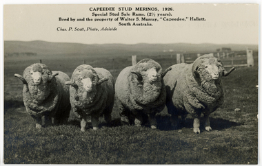
Postcard - Capeedee Stud Rams, Chas P Scott, 1926
This postcard was found loose in the first of three albums compiled and owned by J W Allen, Secretary of New South Wales Grazier's, and is associated with the New South Wales Graziers Association world tour of sheep 1928-1929. The album contains photographs of travel, sheep, farms, stations, people and landscapes from around the world. Locations include Naples, Port Said, Suez, Birregurra (Vic), Alexandra (Vic), Ballangeich (Vic), Keith (SA), Mt Gambier (SA), Buckland Park (SA), Tasmania, Winton (QLD), Sydney Harbour, Canberra (ACT), Toowoomba (QLD), Rockhampton (QLD), Tocal (NSW), Deepwater (NSW), Glen Innes (NSW), Longreach (QLD), Moree (NSW), Barraba (NSW) and Mudgee (NSW). Properties depicted include Mooleric, Turkeith, Woolongoon, Minadale, Crower Station, Merrindie, Koomooloo Station, Cappeedee, Koonoona, Rathmore, Ellenthorpe, Camden Park Station, Glenlegh, Strathmore Station, Ilparran Station, Binneguy, Midkin, Terlings, Ashley, Bereen, Plumthorpe, Mayvale and Havilah. The album was found in a clean out at the Great Southern Agricultural Research Institute and donated to the National Wool Museum, along with other related material such as photographs, glass lantern slides and ephemera.Photographic postcard with four rams standing together in a paddock.Front: CAPEEDEE STUD MERINOS, 1926 / Special Stud Sale Rams (2½ years). / Bred by and the property of Walter S. Murray, “Capeedee,” Hallett, / South Australia / Chas. P. Scott, Photo, Adelaide Back: POST CARD / CORRESPONDENCE / ADDRESS ONLY / KODAK / AUSTRALIA / KODAK / AUSTRALIAworld tour, sheep, graziers, photograph, agriculture, capeedee, rams, stud, south australia, hallett, walter s murray -
 National Wool Museum
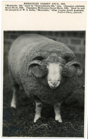
Postcard - Merrindie Dorset Stud, Pulford, 1927
This postcard was found loose in the first of three albums compiled and owned by J W Allen, Secretary of New South Wales Grazier's, and is associated with the New South Wales Graziers Association world tour of sheep 1928-1929. The album contains photographs of travel, sheep, farms, stations, people and landscapes from around the world. Locations include Naples, Port Said, Suez, Birregurra (Vic), Alexandra (Vic), Ballangeich (Vic), Keith (SA), Mt Gambier (SA), Buckland Park (SA), Tasmania, Winton (QLD), Sydney Harbour, Canberra (ACT), Toowoomba (QLD), Rockhampton (QLD), Tocal (NSW), Deepwater (NSW), Glen Innes (NSW), Longreach (QLD), Moree (NSW), Barraba (NSW) and Mudgee (NSW). Properties depicted include Mooleric, Turkeith, Woolongoon, Minadale, Crower Station, Merrindie, Koomooloo Station, Cappeedee, Koonoona, Rathmore, Ellenthorpe, Camden Park Station, Glenlegh, Strathmore Station, Ilparran Station, Binneguy, Midkin, Terlings, Ashley, Bereen, Plumthorpe, Mayvale and Havilah. The album was found in a clean out at the Great Southern Agricultural Research Institute and donated to the National Wool Museum, along with other related material such as photographs, glass lantern slides and ephemera.Photograph postcard with a black and white image of a ram, and printed black text.Front: MERRINDIE DORSET STUD, 1927. / “Merrindie 166” sired by “Symondsbury 264,” imp. Champion Adelaide / Royal Show, 1925. Champion Melbourne Royal Show, 1925. Bred by and / the property of W. S. Kelly, “Merrindie,” Giles Corner, South Australia. / Pulford Photo, Adelaide. Back: POST CARD / CORRESPONDENCE / ADDRESS ONLY / KODAK / AUSTRALIA / KODAK / AUSTRALIAworld tour, sheep, graziers, photograph, agriculture, rams, stud, south australia, merrindie, giles corner, w s kelly, pulford