Showing 613 items
matching location map
-
 Whitehorse Historical Society Inc.
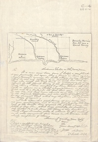
Document - Correspondence, Anderson's Station, 2/10/1842
... on Anderson's adjoining land. Includes sketch map of relative locations... on Anderson's adjoining land. Includes sketch map of relative locations ...Photocopy of a letter from James Anderson dated 2 October 1842 complaining of incursions by stock of Major Newman on Anderson's adjoining land. Includes sketch map of relative locations of neighbouring runs bordered by the Yarra River.anderson, james, newman, (major), dawsons station, ross station, yarra river, agriculture, pioneers, deep creek, nunawading -
 Whitehorse Historical Society Inc.
Map, Mitcham, 1880s?
Hand drawn map of area north and south of Whitehorse Road and South of Canterbury Road c.1880-1900.Hand drawn map of area north and south of Whitehorse Road and South of Canterbury Road c.1880-1900. Probably sketched by a McClare descendant. Includes locations and names of settlers of that time.Hand drawn map of area north and south of Whitehorse Road and South of Canterbury Road c.1880-1900. whitehorse road, mitcham, mitcham road, mitcham, l l vale road, vermont, canterbury road, mitcham -
Whitehorse Historical Society Inc.
Map, City of Nunawading, n.d
... Schools Map of the City of Nunawading with a list and locations ...Map of the City of Nunawading with a list and locations of 48 schools.Map of the City of Nunawading with a list and locations of 48 schools. Scale: 1 mile = 3.75 inches.Map of the City of Nunawading with a list and locations of 48 schools. city of nunawading, schools -
Whitehorse Historical Society Inc.
Map, City of Nunawading, n.d
... of Nunawading Map of the City of Nunawading with a list and locations ...Map of the City of Nunawading with a list and locations of 49 schools.Map of the City of Nunawading with a list and locations of 49 schools. Scale: 1 mile = 3.75 inchesMap of the City of Nunawading with a list and locations of 49 schools. schools, city of nunawading -
 Whitehorse Historical Society Inc.
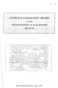
Pamphlet - Report, Church and community profile of the Nunawading and Blackburn region, 1/06/1997 12:00:00 AM
... . A map shows the location of all local Uniting Churches. 20.... A map shows the location of all local Uniting Churches. 20 pages ...A report produced by Maroondah Presbytery of the Uniting ChurchA report produced by Maroondah Presbytery of the Uniting Church examining the state of the church in the Nunawading and Blackburn regions. Churches included are Mount Pleasant, Mountview, Nunawading, Parkmore, St Ninian's, The Avenue, and Vermont Uniting churches and the Nunawading District Young Adult Ministry. Statistical membership figures are given and compared with demographics of the district. Ministerial and other leadership resources are listed. Property details are listed as are community resources provided. Information on Strathdon Community is given. An appendix relates the amalgamation of the Mitcham Methodist and Presbyterian Churches to form Mountview Uniting Church. Another appendix relates a parable: 'Lying Offshore' by William Jones. A map shows the location of all local Uniting Churches. 20 pages.A report produced by Maroondah Presbytery of the Uniting Church mount pleasant uniting church, mountview uniting church, mitcham, nunawading uniting church, parkmore uniting church, forest hill, st ninians uniting church, blackburn south, vermont uniting church, uniting church. young adult ministry, nunawading district, strathdon community -
Whitehorse Historical Society Inc.
Map, M.M.B.W - Schwerkolt Cottage, 30/04/1968
Extract from M.M.B.W. map No 79 showing proposed main road, open space, residential zones C & D and location of Schwerkolt Cottage. Approved 40/04/1968. 2 copiesschwerkolt cottage, melbourne and metropolitan board of works, eastern freeway -
Whitehorse Historical Society Inc.
Map, Aboriginal sites in the City of Doncaster-Templestowe, 1/03/1991 12:00:00 AM
Map of City of Doncaster and Templestowe.Map of City of Doncaster and Templestowe showing location of stone artefacts and scarred trees.Map of City of Doncaster and Templestowe. aborigines, city of doncaster and templestowe -
 Whitehorse Historical Society Inc.
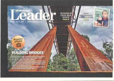
Article, Burwood Link Pedestrian Bridge, 2018
... pedestrian bridge gardiners creek reserve Sketch map of location ...Sketch map of location of potteries in the area bounded by Middleborough, Springfield, Mitcham Roads and Burwood Highway.Photograph of the Burwood Link Pedestrian Bridge at Gardiners Creek Reserve provided by Whitehorse Leader reader Aisling Keogh.Sketch map of location of potteries in the area bounded by Middleborough, Springfield, Mitcham Roads and Burwood Highway.deakin university burwood campus, burwood link pedestrian bridge, gardiners creek reserve -
 Old School House Museum
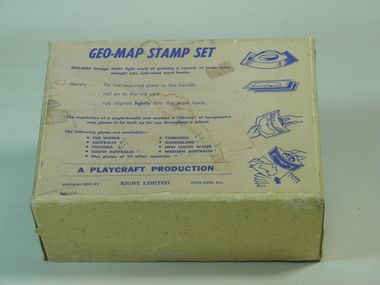
Rubber Stamp Set
Used by teachers for teaching geography, they would take the plate and attach to the handle, stamp it into ink and would make multiple copies for the students to either identify capital and countries or to learn the shape and localities of each locationIt was an early way of making multiple copies for teaching students.Geography stamp set in box which include 4 plates and handle. Plates include, Asia,Africa,Victoria,The world Geo-Map Stamp Setfrankston primary school, rubber stamps, education, geo-map, victoria, asia, the world, africa, playcraft production -
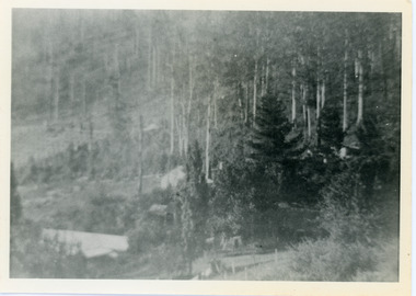 Mt Dandenong & District Historical Society Inc.
Photograph, View Over Roof of "Kalorama"
Taken in 1908, this photograph, though rather blurry, gives an indication of the location of the early settler properties in the valley in relation to one another. European trees have been planted at 'Kalorama' , the first home of Ellis Jeeves. John Lundy-Clarke grew up in the Kalorama/Mt Dandenong area and later in life (1972-74) began to write a comprehensive history of the area working from an original settlement map in an effort to cover all areas.Black and white photograph looking across hillside with large trees and rooftops visible. Handwritten description on reverse by John Lundy-Clarke.1908 View over roof of “Kalorama” towards the Falls. Paynter’s house on LOT 29 in low centre (now “Yosemite”). Pimms house on LOT 19 above Paynters and beyond scrub. Logan’s house faint above left of “Kalorama”. Dunbar’s LOT 20 beyond Pimm’s orchard. Gum trees on right were on Price’s LOT 19 now Tosari Rd area. It was one of these that figured in the episode of the runaway log in 1930. It leaped in one bound over Barbers Road at bottom of scrub in centre of picture then over Logan’s house.kalorama, ellis jeeves, jeeves -
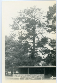 Mt Dandenong & District Historical Society Inc.
Photograph, Hand's Pine Tree in Kalorama Reserve
Kalorama Memorial Reserve was once the location of 'Mountain Grange', the property of Thomas and Eliza Hand. The pine tree pictured was reputedly planted by Mrs Eliza Hand in the 1880s. Thomas Hand died in 1888 when he was thrown from his horse on Inverness Road. The photograph was taken in 1974 and the pavilion pictured is no longer there. John Lundy-Clarke grew up in the Kalorama/Mt Dandenong area and later in life (1972-74) began to write a comprehensive history of the area working from an original settlement map in an effort to cover all areas.Black and white photograph showing a large pine tree behind a pavilion. Handwritten description on reverse by John Lundy-Clarke.Hand’s pine tree in Kalorama reserve. Planted 1874 approx. Pictured 14-3-73.kalorama memorial reserve, kalorama oval, mountain grange, thomas hand, eliza hand, pine tree, pavilion -
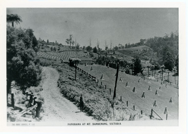 Mt Dandenong & District Historical Society Inc.
Photograph, View From Corner of Doughty's Road and Barbers Road 1913
John Lundy-Clarke grew up in the Kalorama/Mt Dandenong area and later in life (1972-74) began to write a comprehensive history of the area working from an original settlement map in an effort to cover all areas. Taken c1913, this photograph gives a clear indication of where significant buildings were located in relation to one another. Barbers Road is running through the picture with the guest house 'Kia-Ora' , built by George Barber in the centre. High on the skyline on the left is the 'Mountjoy' guesthouse, indicating the location of The Gap, or FiveWays. The small 'boxy' house above 'Kia-Ora' is 'Iona' built by the Paynter family who also built 'Mountjoy'. The Jeeves property 'Kalorama' is to the right of 'Iona' and this is the area you now look to from the FiveWays Lookout. The man in the photo is wearing a trilby hat so is probably a Rose Series employee - a feature in many Rose Series postcards.Black and white photograph that is a copy of Rose Series Postcard # 156. A man can be seen walking down an unmade road with haystacks to his right. Buildings and crops can be seen on the hillsides. Handwritten inscription on reverse by John Lundy-ClarkeView from corner of Doughty’s and Barbers Road 1913. “Kia Ora” in centre Paynter’s “Iona” near center skyline above “Kia Ora” with “Kalorama” on its right and Peter’s hut of the time below it among orchard trees. “Mountjoy” is on left skyline. W. Haye’s home is centre left. Hay paddock is Barbers Lot 25 Village Settlement.kia-ora, iona, kalorama, mountjoy, guesthouse, guest house, barbers road, doughty's road, paynter, jeeves, george barber -
Southern Sherbrooke Historical Society Inc.
Information folder - Elvery family
Folder contains information pertaining to the Elvery family of Belgrave Heights. Contents: -Trifold A3 pamphlet, glossy paper, black, white and orange "The Lodge Just the perfect place to stay" c1990s advertisement flyer. -Map, hand-drawn with photos attached, "9 Hole Golf Course. Belgrave Heights - 1930-1943". Photocopy of large poster made by Betty DeCoite (original in map drawer) -Photocopy of photo, annotated in ink "Photo taken in Dandenongs - possibly Monbulk/the Patch? Photo supplied by David Elvery 2/6/99" -Photocopy of photo, Belgrave South Football Club team, probably 1945, plus list of names of team - from David Elvery 2/6/99 -printout, State Library of Victoria Multimedia Catalogue, Rose Series postcard of "Sunnyside Lodge" Lockwood, Belgrave South -copy of printed letter from David Elvery to CEO Shire of Yarra (sic) dated 8/6/99 re. vegetation on Mt Morton. Handwritten additions plus p'copy of Valentine Series postcard #3832 "Panorama From Mount Morton, Belgrave Heights" -p'copy of typed speech with annotations, by Rev. A.C. Beckingham at the opening of Lockwood -p'copy of photo, Harrison and Dalny Elvery and children David and Wendy c1936. Annotated by David Elvery 30/5/99 -printout, SLV Multimedia Catalogue, Rose Series postcard "Lockwood House" Lockwood, Belgrave South -p'copy, subdivision map "Lockwood Estate" lodged plan 6548 -p'copy, subdivision map Lockwood area, plan #6970 -A3 sheet, p'copies 6 postcards of Belgrave Heights -p'copy photo Elvery house, later "Sunnyside" and "Devon Lodge" annotated by David Elvery 2/6/99 -3 p'copied photos, Belgrave Heights, possibly Varney's butchers shop, possibly Whitlam residence. Annotated by David Elvery -2 p'copied photos, "Lockwood House", Golf links (Bill Woodfull, Principal of Upwey High School in photo), annotated David Elvery 2/6/99 -2 photos from David Elvery - moving Melbourne tram into "house" location at Lockwood, and bus "W. Dyke" unknown date and location. -3 photos from David Elvery - David on Gypsy (pony) Mt Morton Rd c1937, Wendy and David at entrance 37 Lockwood Rd c1942, David on Mack (horse) on golf links c1947 -Photo Arthur and Harrison Elvery, Lockwood House in background c1916 -photo Mrs Elvery, p'copy of postcard 26/3/20 addressed to "Dear Maud", mentions Charlie's wife and Laura (incomplete) -photo George Rae (Narre Warren North) Harold Allen and three other boys c1939 -6 photos, unlabelled (duplicates?) -photo Orchard Rd, Belgrave Heights -photo unlabelled, woman with child in pram, house in background (Lockwood?) -photo David Elvery on Gypsy as above -Rose postcard P2032 "Lockwood" Belgrave, Victoria -photo David Elvery on Mack (as above) -photo Wendy and David Elvery (as above) -2 photos, tram being moved (as above), football team -p'copy of Certificate of Title Vol.4562 Fol. 912336 dated 31/1/1922 - see list of names in folder -p'copy Memorial of Instruments (Land Title) dated 14/1/1914 -p'copy Cert. of Title Vol. 4562 Fol. 912335 dated 31/1/1922 -handwritten note, David Elvery to Susan Heywood-Downard -p'copy Memorial of Instruments dated 14/1/1914 -p'copy subdivision map, area bounded by Glen, Orchard, Avonside and Bay Rds, Belgrave Heights -p'copy Cert. of Title, Vol. 4810 Fol. 961945, dated 2/1/1924 -p'copy Cert. of Title, Vol. 4562 Fol. 912337, dated 31/1/1922 -Typed list of photo caption, relating to some of above photos -List of names and dates appearing on land title documents enclosed -Printout, Australian Dictionary Of Biography - Davies family - handwritten addition, marriage details, Arthur Elvery & Hannah Ord. -Printout - Family Search, Maria Louisa Davies, and family group, Ebenezer Davies & Ruth Bartlett. -letter to editor, Northern Star, Lismore, NSW, 11 Aug. 1923, Hannah Elvery, re. sport on Sunday -typescript - Elvery Family History, part of the "Alstonville" Elvery story, supplied by David H. Elvery 30th May 1999. From Bob Quincey.elvery family, lockwood house, belgrave heights, devon lodge -
 Ballarat Tramway Museum
Map, Electric Supply Co. of Vic (ESCo), Ballarat Electoral Map - ESCo, 1900
Document prepared by the Electric Supply Co of Victoria, as part of an order under the Electric Light and Power Act 1896, section 5 of order No. 17 granted to company. Dated 19/2/1901 and signed by the Postmaster-General. Shows the order area being parts of the City of Ballaarat, Sebastopol and Ballarat East. Shows the street names, boundaries, principal power line routes, land reserves, parks, mine locations, railways and Lake Wendouree. Signed by R L Williams Town Clerk City of Ballarat, J R Hall for the Borough of Sebastopol, and John Gent for the Town of Ballarat EastYields information about the power supply to the Ballarat area.Cloth backed paper map, coloured and marked up as exhibit 17.Notes in ink including the signature of Benjamin Deakin 24/9/00 and certified by the three involved municipal Town Clerks.ballarat power supply, esco, electric supply co of victoria, city of ballaarat, east ballarat, sebastopol, orders, power lines, power supply -
 Ballarat Tramway Museum
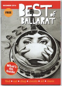
Book, Scott Bain, "Best of Ballarat", Nov. 2016
Book - 44 pages, centre stapled, full colour, titled "Best of Ballarat", for Dec 2016. Gives details of events, locations, hotels, food etc - a What's on in Ballarat. Has the Peter Bruce photo (see Reg Item 6702) on page 19 under attractions and tours, and on page 21, adverts for the BTM and Cuthberts939. 6703.2 - ditto - for April 2017, images i4 to i9, including cover, Sturt St, BTM, maps - added April 2017. 6703.3 - ditto for August 2017, images i10 to i12- includes cover, photo of the interior of Cuthberts939 on page 23 and a general advert on page 24 - added August 2017. 6703.4 - ditto for Feb. 2018, images i13 to i15 includes cover, Welcome to Ballarat including photo of a Bugatti motor car and tram 18 in Lydiard St North, c late 1940's and the general advert on page 24 - added Feb. 2018. The image with the Bugatti is from the State Library of Victoria.trams, tramways, ballarat, btm, events, hotels, cuthberts 939, lydiard st north -
 Ballarat Tramway Museum
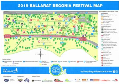
Map, City of Ballarat, "2019 Ballarat Begonia Festival Map", Mar. 2019
Map - printed in colour of off white paper titled "2019 Ballarat Begonia Festival Map" showing the various event locations in the Gardens area for the 2019 festival. Shows the tram stops and festival sponsors. On the rear is the program for each of the three days between 9/3/19 and 11/3/19.trams, tramways, begonia festival, map, events, btm -
 Ballarat Tramway Museum
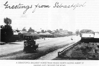
Book, E.D. Jenkins and Lloyd Jenkins, "Sebastopol Victoria - A Historical Survey of Early Sebastopol - 1864- 1964", 1989
Book - 92 pages plus card covers, a historical survey of the Sebastopol district. Originally written by E.D. Jenkins for the Borough of Sebastopol's centenary in 1964, reprinted with additional text by Lloyd Jenkins to recognise the 125th anniversary of the Borough covering the years 1965 to 1989. Book covers mining history, churches, the Borough Council, early days of the district and various points, eg cabmen, horse trams and electric trams, schools, the Mechanics Institute, various clubs, fire brigade, hotels, industries, and programme of events to celebrate the centenary. The second part of the book, covering the period is laid out in a chronological order with forward by Cr. Donald, the Mayor with many photographs. Centre page has a large map of the district showing the many mines, leads, roads and other historic locations. Tramway photos are horse tram No. 7, ESCo 17 at depot (all on file) and a photo showing a horse tram heading north along Albert St. with the shopping centre in the background - see image. Photo taken just after the tram has crossed the roadway. Copy of the horse tram heading north along Albert St. made Oct. 2001 for the "gold, Gold GOLD" temporary exhibition - colour laser print onto card, with Velcro dots on rear. Stored in box D1 (Display Box) 02/2003. See Reg Item 3883 for another print of this photograph.On page 3 in black ink "Ballarat Tramway Museum Inc. With compliments, D.L. Jenkins 14/4/1999"trams, tramways, sebastopol, local history, public transport, mining, horse trams, esco -
Ballarat Tramway Museum
Document - Report, Maunsell Pty Ltd, "City of Ballarat - Feasibility Study for Reinstatement of the Ballarat Trams - Final Report - July 1998", Jul. 1998
Thirty six page (A4) plus 10 folded A3 pages report with clear plastic cover, card rear cover and bound using a white comb binder, featuring a black and white photograph of BTM No. 33 on front cover. Report titled "City of Ballarat - Feasibility Study for Reinstatement of the Ballarat Trams - Final Report - July 1998". Report looks at background, geometric criteria, depot location, alignment proposals, the BTM, existing tramcars, availability and sources of materials, tramcar requirements, operational equipment and has an Appendix. Prepared as revision F, Final report 31/7/1998 by Richard Darby of Maunsell Proprietary Limited in association with Allom Lovell and Associates Pty Ltd. Contains a A3 map of the main area of "original tramway system" - excludes Sebastopol and ends of Mt Pleasant and Victoria St. lines. Has three State Library of Victoria photos of Ballarat, three folded A3 sheets containing 12 photographs each of the 1998 conditions, four fold A3 sheets of the proposed route showing photo locations, suggested loops and two folded A3 sheets of cross sections.trams, tramways, city tramway, ballarat tramways, maunsell, tramway revival -
 Ballarat Tramway Museum
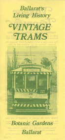
Pamphlet, Ballarat Tramway Preservation Society (BTPS), "Ballarat's Living History / Vintage Trams / Botanic Gardens Ballarat", Sep. 1984
... map on rear showing location of Lake Wendouree and tramway...". Printed by Hoskin Print Ballarat, dated 1 Sept. 1984. Has RACV map ...Yields information about how the BTPS promoted the tramway, with the Design by the printer and the BTPS.Pamphlet advertising the Ballarat Vintage Tramway produced in 9/1984 on yellow paper with black ink on rear giving details of the operation, address etc. and on the front in green ink, a head on photo of No. 26 (prior to conversion)and the title " Ballarat's Living History / Vintage Trams / Botanic Gardens Ballarat". Printed by Hoskin Print Ballarat, dated 1 Sept. 1984. Has RACV map on rear showing location of Lake Wendouree and tramway. 1664i1 - image of front, i2 - image of rear.trams, tramways, btps, pamphlets, ballarat vintage tramway, racv -
Ballarat Tramway Museum
Document - Report, Connell Wagner, "Ballarat Heritage Tram Route Concept Engineering Assessment", Mar. 2002
Seventy Seven page A4 size document, bound with clear plastic cover, black coloured card back cover using a black comb binder, titled "Ballarat Heritage Tram Route Concept Engineering Assessment". Produced by Connell Wagner for Booz Allen Hamilton as part of the project study for the return of trams to the central part of the City of Ballarat. Draft Document, dated 1/3/2002. Has an introduction, looks at the concept for each section of the route with a photograph showing possible route, features, looks at passing loop locations, tram stop locations, substations, potential depot sites, concept construction costs and has maps of preferred route and alternative routes, depot options. Note folio page 40 assumes the track in the pavement at Armstrong St was the original track - not the replica crossing to the Phoenix foundry. Has an index.trams, tramways, ballarat city tramway, ballarat revival, civil engineering, depot -
Ballarat Tramway Museum
Document - Report, Connell Wagner, "Ballarat Heritage Tram Route Concept Engineering Assessment", 22/03/2002 12:00:00 AM
Forty Eight sheet A4 size document, unbound, printed mainly double sided "Ballarat Heritage Tram Route Concept Engineering Assessment". Produced by Connell Wagner for Booz Allen Hamilton as part of the project study for the return of trams to the central part of the City of Ballarat. Document, dated 1/3/2002. See Reg, Item 2273 for a bound draft version of this document. Has an introduction, looks at the concept for each section of the route with a photograph showing possible route, features, looks at passing loop locations, tram stop locations, substations, potential depot sites, concept construction costs and has maps of preferred route and alternative routes, depot options, concept construction costs, typical track cross sections and costing detail. Has an index.trams, tramways, ballarat city tramway, ballarat revival, civil engineering, depot -
 Ballarat Tramway Museum
Photograph - Colour Photocopy/photocopies, 2004
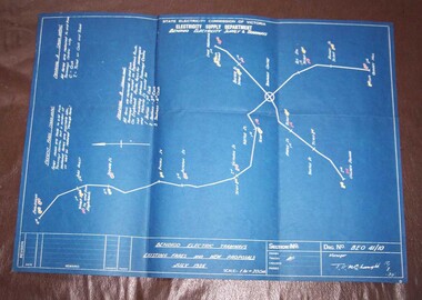
Colour print from a scanned image of a blueprint drawing, BEO 41/10 titled "Bendigo Electric Tramways / Existing Fares and New Proposals / July 1935". Has date of 18/7/1935, shows a map of the Bendigo system, with current fares to various points, and two proposal A - shown in yellow (cash and ticket) and B shown in red. Gives various locations on the tramways. Scanned image prepared by joining six portions into one using photoshop by W. Doubleday. Image made 9/3/2005. Image 1 is of the blue print itself - forwarded to Bendigo Tramway Image 2 is a jpg of colour scanned image. high density image on the special image files directory.bendigo, fares, tickets -
 Ballarat Tramway Museum
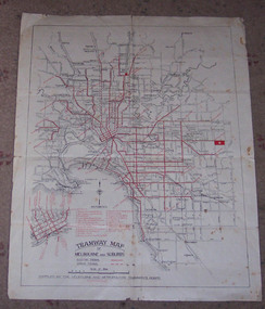
Map, Melbourne and Metropolitan Tramways Board (MMTB), "Tramway Map of Melbourne and Suburbs", 1930c
Two colour map of Melbourne tramway Network, undated, but post the conversion of Collins St to electric trams (late 1929), c1930. Shows both electric and cable lines, various locations, eg the Motordrome, railway lines and primary streets. Compiled by the MMTB.On rear in pencil over three locations "Young Asst Mgr", "Young" and "L Calder? 6 Inglis? Wahroonga"trams, tramways, mmtb, map, cable trams, conversion -
 Ballarat Tramway Museum
Pamphlet, The Bendigo and District Tourist Association, "Bendigo & District tourist guide", 1972
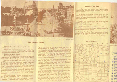
... and Bendigo today, along with a map of the important tourist features... map showing the location of the various district features ...Folded printed pamphlet, four folds, printing in blue and brown ink on fawn paper, titled "Bendigo & District tourist guide", giving a historical outline of the district history and Bendigo today, along with a map of the important tourist features in the CBD area. On the reverse has a district map showing the location of the various district features. Published by The Bendigo and District Tourist Association in 1972. Three copies held.trams, tramways, bendigo, bendigo trust, map -
 Ballarat Tramway Museum
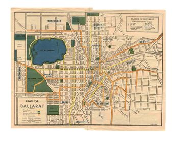
Map, Greater Ballarat Association and George Netherway, "Map of Ballarat", c1945
Yields information about Greater Ballarat, including trams, buses, locations and streets. Has a strong association with George Netherway.Five colour map of Ballarat, showing streets, places of interest, Parks, tram routes, bus routes, railway lines, prepared by G. C. Netherway, Greater Ballarat Association, for the Victorian Government Tourist Bureau, Ballarat Branch, c1945. Shows suburbs names, location of orphanage, the lack of development north of Howitt St, in Wendouree. Map is part diagrammatic and is not entirely to scale. On rear is a road map of the Ballarat area, lists of statistics, beauty spots, look outs, art and culture, points of historical interest, industrial products and recreation. Note: Image 1, assembled from four scans, does not entirely match at edges. See Reg item 2074 for photographic image of another version map. See Reg Item 5613 for another version of this map. trams, tramways, ballarat, tram routes, bus routes, map, lists -
 Ballarat Tramway Museum
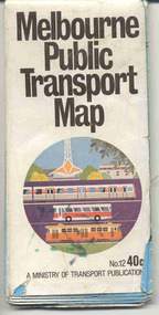
Map, Ministry of Transport, "Melbourne Public Transport Map" - "No. 12", 1982
... . On the rear, a sketch map showing the location Charles St, Mantell St.... On the rear, a sketch map showing the location Charles St, Mantell St ...Pocket size - folded - public transport map of Melbourne, printed in colour on paper, showing public transport services in greater Melbourne, including ticketing information, travelcards and an index of localities. The Central zone area shown in detail. On the rear, route numbers and line maps of tram routes and train lines or services and fare zones. The first map with the new three zone system of fares. Includes private bus routes. Printed 1982 by Government Printer. Issue No. 12.On inside, a circle route around Flinders, Queen, Little Collins and Swanston St in blue felt pen and arrow in blue ink. On the rear, a sketch map showing the location Charles St, Mantell St and William Road, and a circle around Upfield station.trams, tramways, melbourne, map, routes -
 Ballarat Tramway Museum
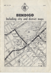
Map, Royal Automobile Club of Victoria, "Bendigo Including city and district maps - RACV", c1968
... the location of crossing loops on and off the map and the location... notes showing the location of crossing loops on and off the map ...Printed street map titled "Bendigo Including city and district maps", published by the RACV, showing the central part of Bendigo on the front cover, Bendigo Outlets and notes on the city itself. Has the tram lines shown dotted, only shows the full extent of the Golden Square line. Inside has a district road map. The front cover has the number "0468" in the bottom left hand corner, indicating the publication date.in ink on the Bendigo Outlet map, has various notes showing the location of crossing loops on and off the map and the location of the tram depot itself.trams, tramways, map, bendigo, racv, railways -
 Ballarat Tramway Museum
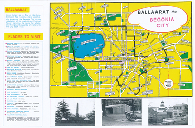
Pamphlet, Earl Ewers, "Ballaarat Begonia Festival - 1971", Sep. 2011
Yields information about the form of advertising the Ballarat Begonia Festival undertook and the relationship with Victour, the Victorian Govt. Tourist Bureau.Colour photocopy of a advertising brochure for the 1971 Ballaarat Begonia Festival - copied onto two A3 sheets. Has a map of the city showing the tram tracks, bowling greens, parks, and various locations. Gives Places to visit, programmes and Victour addresses and details. Originally published by the Ballaarat Begonia Festival Association and the Greater Ballarat Association and printed by Hedges and Bell. Three copies held. See Reg Item 2154 for the actual festival programme.trams, tramways, begonia festival, ballarat, map -
 Ballarat Tramway Museum
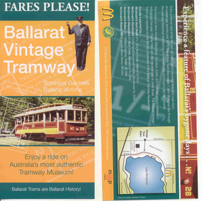
Pamphlet, Ballarat Tramway Museum (BTM), "Fares Please! / Ballarat Vintage Tramway", Aug. 2008
Yields information about how the BTM promoted the tramway, with the assistance of McDonalds. Design by the printer and Stephen Butler.Printed single sheet pamphlet, advertising BTM Vintage Tramway, titled "Fares Please!" featuring Frank Puls, a 1/- ticket and tram 26 on one side, map, details and McDonalds Wendouree on reverse. Printed in green, orange and black and white on light art paper. Includes BTM web address and McDonald's logo on rear, giving five locations of McDonalds, including the Western Highway at Ballan, Tourism and Museum Accreditation logos Introduced late August 2008. See Reg Item 2443 for previous version and 6123 for next version.trams, tramways, mcdonalds, btm, ballarat vintage tramway, botanical gardens -
 Ballarat Tramway Museum
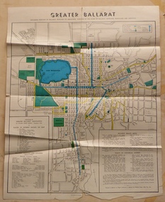
Map, Greater Ballarat Association and George Netherway, "Map of Ballarat", c1950
Yields information about Greater Ballarat, including trams, buses, locations and streets. Has a strong association with George Netherway.Four colour map of Ballarat, showing streets, places of interest, Parks, tram routes, bus routes, railway lines, prepared by G. C. Netherway, Greater Ballarat Association. Shows suburbs names, location of places of interest, some development north of Howitt St, in Wendouree. Map is part diagrammatic and is not entirely to scale. Includes the Lake Wendouree Rowing course On rear is a road map of the Ballarat area, lists of statistics, beauty spots, look outs, art and culture, points of historical interest, industrial products and recreation. Printed by Waller & Chester on paper produced by Ballarat Paper Mills Pty Ltd. See Reg item 2074 for photographic image of this version of the map. See Reg Item 2776 for another version of this map. Contained originally within Reg Item 5507 at the back of the binder. For items see btm5507 loose items list.pdf John Whiting in an email of 17-9-2021 noted: The rowing course along Lake Wendouree is noted, so perhaps this map is post 1956? The Mt Pleasant tram line is shown to terminate at Morton St, not Cobden St (which of course is incorrect) Someone's come along and drawn in black ink the branch of the View Point tram line!trams, tramways, ballarat, tram routes, bus routes, map, lists