Showing 4627 items matching "history records"
-
 Kiewa Valley Historical Society
Photographs – Lakeside Avenue, Mt Beauty. Circa 1993. Set of 7 colour photographs
Established in 1946, during the construction of the Kiewa Hydro Electric Scheme, the township of Mt Beauty was developed by the State Electricity Commission of Victoria to provide additional accommodation for the thousands of workers during the construction of the country’s second largest hydro-electricity scheme. Although these towns were built as temporary accommodation for the workers and their families, many stayed after the scheme finished. Combined with the influx of European migrants, with their rich cultural backgrounds, all played a major part in shaping the future character of the Mount Beauty, the Kiewa Valley and Falls Creek. The Bright Council, now the Alpine Shire took over the control of the township in 1960. This relatively young town of Mount Beauty, along with the surrounding townships of Falls Creek, Bogong, Tawonga South and Tawonga, are all part of a prospering tourist area with excellent services, accommodation, food and a wide range of recreational activities available for all ages. According to Shire records, the population of Mt Beauty has grown from 1,500 in 1981 to 1,800 in 2016 with a projected increase to 2,000 in 2013The photographs taken around 1993 show a prosperous commercial centre catering for both locals and the needs of visitors. It provides a pictorial history of the changes which have occurred in the retail/commercial district of Mt Beauty over the years. It also demonstrates the attention paid by Alpine Shire towards providing accessible recreational green space around the town centre.Set of 7 colour photographs of Lakeside Avenue, Mt Beauty. Circa 1993 showing retail services and streetscape of the time. No markingsmt beauty, lakeside ave mt beauty -
 Kiewa Valley Historical Society
Photographs – Tawonga Cres., Mt Beauty. Circa 1993. Set of 4 colour photographs
Established in 1946, during the construction of the Kiewa Hydro Electric Scheme, the township of Mt Beauty was developed by the State Electricity Commission of Victoria to provide additional accommodation for the thousands of workers during the construction of the country’s second largest hydro-electricity scheme. Although these towns were built as temporary accommodation for the workers and their families, many stayed after the scheme finished. Combined with the influx of European migrants, with their rich cultural backgrounds, all played a major part in shaping the future character of the Mount Beauty, the Kiewa Valley and Falls Creek. The Bright Council, now the Alpine Shire took over the control of the township in 1960. This relatively young town of Mount Beauty, along with the surrounding townships of Falls Creek, Bogong, Tawonga South and Tawonga, are all part of a prospering tourist area with excellent services, accommodation, food and a wide range of recreational activities available for all ages. According to Shire records, the population of Mt Beauty has grown from 1,500 in 1981 to 1,800 in 2016 with a projected increase to 2,000 in 2013The photographs taken around 1993 show a prosperous commercial centre catering for both locals and the needs of visitors. It provides a pictorial history of the changes which have occurred in the retail/commercial district of Mt Beauty over the years. It also demonstrates the attention paid by Alpine Shire towards providing accessible recreational green space around the town centre.Set of 4 colour photographs Tawonga Crescent, Mt Beauty. Circa 1993 showing retail services and streetscape of the time No markingstawonga cres mt beauty -
 Kiewa Valley Historical Society
Photographs – Holland Street North, Mt Beauty. Circa 1993. Set of 18 colour photographs
Established in 1946, during the construction of the Kiewa Hydro Electric Scheme, the township of Mt Beauty was developed by the State Electricity Commission of Victoria to provide additional accommodation for the thousands of workers during the construction of the country’s second largest hydro-electricity scheme. Although these towns were built as temporary accommodation for the workers and their families, many stayed after the scheme finished. Combined with the influx of European migrants, with their rich cultural backgrounds, all played a major part in shaping the future character of the Mount Beauty, the Kiewa Valley and Falls Creek. The Bright Council, now the Alpine Shire took over the control of the township in 1960. This relatively young town of Mount Beauty, along with the surrounding townships of Falls Creek, Bogong, Tawonga South and Tawonga, are all part of a prospering tourist area with excellent services, accommodation, food and a wide range of recreational activities available for all ages. According to Shire records, the population of Mt Beauty has grown from 1,500 in 1981 to 1,800 in 2016 with a projected increase to 2,000 in 2013The photographs taken around 1993 show a prosperous commercial centre catering for both locals and the needs of visitors. It provides a pictorial history of the changes which have occurred in the retail/commercial district of Mt Beauty over the years. It also demonstrates the attention paid by Alpine Shire towards providing accessible recreational green space around the town centre.Set of 18 colour photographs Holland Street North, Mt Beauty. Circa 1993 showing retail services and streetscape of the time. No markingsholland st mt beauty, mt beauty -
 Kiewa Valley Historical Society
Photographs – Holland Street South, Mt Beauty. Circa 1993. Set of 16 colour photographs
Established in 1946, during the construction of the Kiewa Hydro Electric Scheme, the township of Mt Beauty was developed by the State Electricity Commission of Victoria to provide additional accommodation for the thousands of workers during the construction of the country’s second largest hydro-electricity scheme. Although these towns were built as temporary accommodation for the workers and their families, many stayed after the scheme finished. Combined with the influx of European migrants, with their rich cultural backgrounds, all played a major part in shaping the future character of the Mount Beauty, the Kiewa Valley and Falls Creek. The Bright Council, now the Alpine Shire took over the control of the township in 1960. This relatively young town of Mount Beauty, along with the surrounding townships of Falls Creek, Bogong, Tawonga South and Tawonga, are all part of a prospering tourist area with excellent services, accommodation, food and a wide range of recreational activities available for all ages. According to Shire records, the population of Mt Beauty has grown from 1,500 in 1981 to 1,800 in 2016 with a projected increase to 2,000 in 2013The photographs taken around 1993 show a prosperous commercial centre catering for both locals and the needs of visitors. It provides a pictorial history of the changes which have occurred in the retail/commercial district of Mt Beauty over the years. It also demonstrates the attention paid by Alpine Shire towards providing accessible recreational green space around the town centre.Set of 16 colour photographs Holland Street South, Mt Beauty. Circa 1993 showing retail services and streetscape of the time. No markingsholland st mt beauty, mt beauty -
 Kiewa Valley Historical Society
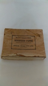
Photographs of small box originally used to contain sensitized photographic paper
The Junction Dam and Clover Dam Power Station, stages of the Kiewa Hydro-Electric Scheme, were needed to meet the increased power demands of the wartime industry in Victoria. Clover added 26 megawatts to the grid. Junction Dam was completed and ready to hold water by September 1943, but was emptied in December 1943 and not filled again until May 1944. Construction of Clover Power Station commenced in July 1941 and both turbines were in service by May 1945.Clover Power Station and Junction Dam were part of the Kiewa Hydro Electric Scheme constructed by the State Electricity Commission of Victoria. SECV official photographers took photographs of most stages of construction of the Hydro Electric Scheme and referenced each photo with a number and dating system as an historical record and for reference for other projects. This provided a thorough history of the construction of the Hydro Electric Scheme, some of the workers involved in its construction and the infrastructure supporting its construction, such a Bogong Village.Small light brown cardboard box originally containing sensitized photographic paper, now containing a range of black and white photographs of the Kiewa Hydro Electric System taken by the official SECV photographer Box has some damage – Front panel on lid is missing. Top has a puncture in top right corner and some peeling of paper along sides and at edges. Printed on the top of the box in black ink: OPEN ONLY IN PHOTOGRAPHIC DARK ROOM SENSITIZED PAPER Manufactured by – KODAK (A/asia) PTY. LTD. Melbourne Australia Green and white sticker on right side of lid and bottom right side of box, torn at join 1. 1B1 Single Weight Soft. Available in Soft (1) Medium (2) Contrast (3) Extra Contrast (4) Single and Double Weight Stamped at bottom of sticker in grey ink G8087 CK photographic paper box; state electricity commission of victoria; official photographer; kiewa hydro electric scheme; clover power station; junction dam; bogong village -
 Kiewa Valley Historical Society
Photographs – Set of 10 black and white photographs and photocopies of original photographs documenting early residents of Bogong Village
... . This group of photographs are a pictorial record of the early history ...Bogong Village, which was known as “The Junction”, is well recorded. The first tent camp was at the junction of Pretty Valley and Rocky Valley streams in the early 40’s. Further downstream were the sawmill, stables and blacksmith’s forge. Horses were the main mode of transport in the early days. The road to Bogong had reached the lookout spur just beyond Roper’s Spur track just before the 1939 fires. The early forties saw rapid growth of the village, with single and married men’s quarters, workshops, mess huts and administrative offices. The facilities necessary for communal living were quickly in place- a post office, police station, co-op store, medical centre, community hall/theatre, tennis courts and school. Much of the temporary accommodation that housed groups such as the Albion Quarrying Company were in the area now under water.This group of photographs are a pictorial record of the early history of the Kiewa Hydro Scheme, the people who worked in the background supplying administrative support and the workers and their families. It also shows a glimpse into how a large group of people from very diverse backgrounds came together to enjoy social activities and share each others companyGroup of 10 black and white photographs and photocopies of original photographs of varying sizes (some official SECV photos) Some Photos are labelled with the date and the names of SECV staff members. Depicting early life at Bogong Village 1. Group photo – Kiewa House Residents 1.8.41 (SECV official photo) 2. Female staff residents 3. Female office staff 4. Kitchen staff – Junction Mess (SECV official photo) 5. Male administration staff Bogong 6. Bogong Social Club fancy dress ball, 1940 7. Wives and children of SECV workers 8. Children in fancy dress 9. Opening of Volunteer Air Observers post 1943 10. Flag raising at opening of Volunteer Air Observers post 1. Printed under photo: STATE ELECTRICITY COMMISSION OF VICTORIA Date: 1.8.41 Time: 12.30pm No:K 435 Kiewa Hydro-Electric Works. Kiewa House Residents Back Row L to R: S.A. Salmon, W. Strachn, T.A Connors, W.J Norman, R.C Grealey, R.D Hegarty, Mrs Hegarty, W.R Morgan, S.A Clarke, P. Morgan, P.J. Harnetty, G.W Crouch. Front Row L to R: W.L Godfrey, R.S Hollands, Pte. R Charlesworth, R.L Dunn, N Caldwell, L.T Davies, I Webber, H.L Kendall, P Tiller, Ricky Hegarty, L.T Guy, M.C Cox, K.F Calder, D.S Gibson 2. Printed on bottom: Staff who lived at Kiewa House and worked in the Administration Office c 1943 Handwritten at bottom Priscilla Johnson (nee Reid) At top of page A GOOD LIFE: WOMEN’S RECOLLECTIONS OF LIFE IN THE UPPER KIEWA VALLEY 3. Printed under photo- Office Staff – Bogong 4. Printed under photo: STATE ELECTRICITY COMMISSION OF VICTORIA Date: 18.5.40 Time: 11.05am No:K 103. Kiewa Hydro-Electric Works. Kitchen Staff- Junction Mess. Opening night of the new staff mess Bogong. 5. Printed under photo -Administration staff Bogong 6. Printed under photo- The social club raised money for patriotic fund from fancy dress nights. (1st Fancy Dress Ball, Bogong 1940) 7. Printed above photo: ---- and family life begins (1942 Bogong) 8. Printed under photo: A favourite photograph 9. Printed under photo: STATE ELECTRICITY COMMISSION OF VICTORIA Date: 24.5.43 Time: 2.8pm No:K 1151 Kiewa Hydro-Electric Works. Bogong- Squadron Leader Leggett speaking at opening of Air Observer’s Post 10. Printed under photo: Raising the flag at the opening of the Volunteer Air Observer’s Post at Bogong - 1943 bogong village; kiewa hydro electric scheme; social activities; community clubs -
 Kiewa Valley Historical Society
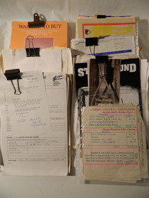
Records of KVHS 1980 - 1989, 1980 - 1989
Kiewa Valley Historical Society was very active during the 1980's culminating in the publication of their book 'The History of the Kiewa Valley'. The papers reflect the activities during this time and contribute to the society's history.The papers contribute to the history of the KVHS and provide provenance for the group and the items in its collection.Collection of papers and pamphlets clipped in groups together containing correspondence & minutes of the KVHS between 1980 and 1989.kiewa valley historical society -
 Kiewa Valley Historical Society
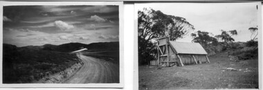
18 small black and white photographs of the Bogong High Plains, 1948
These photos of the Bogong High Plains were all taken by Ronald George Thorn who was a cadet engineer with the State Electricity Commission. He worked on the Kiewa scheme from 1948 to 1950 doing overhead line construction and maintenance plus electrical design and drawing work. They are from his personal collection and a record of his time in the Kiewa area.Pictorial history of personal involvement in the the early days of the Kiewa Scheme.18 small black and white photographs all taken on the Bogong High Plains.Photo 1 Wallace's Hut. Photo 2 Ruined Castle - Looking towards Pretty Valley December 1948. Photo 3 Ruined Castle - Looking towards Pretty Valley December 1948. Photo 4 Ruined Castle - Looking Down Valley December 1948. Photo 5 - Mt. McKay from Ruined Castle October 1948. Photo 6 View from Rocky Valley Camp October 1948. Photo 7 Mt. Feather Top from Ruined Castle October 1948. Photo 8 View from Ruined Castle looking downwards towards Beauty October 1948. Photo 9 Rocky River from gauging station October 1948. Photo 10 Rocky Valley River from main road October 1948. Photo 11 View along little Arthur Fire Track October 1948. Photo 12 View along main road. Looking towards Beauty Valley October 1948. Photo 13 View from Little Arthur Fire Track October 1948. Photo 14 Frying Pan Spur from Rocky Valley Road October 1948. Photo 15 Mt. Bogong from Big Hill Fire Track October 1948. Photo 16 View from Big Hill Fire Track October 1948. Photo 17 Mt. Feathertop from Ruined Castle October 1948. Photo 18 Mt. Fainter from Ruined Castle October 1948. (All of the above is hand written on the back of photos in ink). bogong high plains; r g thorn; secv; kiewa hydro electric scheme; pictorial history -
 Kiewa Valley Historical Society
Photographs – Kiewa Cres Mt Beauty. Circa 1993. Set of 12 colour photographs, circa 1993
Established in 1946, during the construction of the Kiewa Hydro Electric Scheme, the township of Mt Beauty was developed by the State Electricity Commission of Victoria to provide additional accommodation for the thousands of workers during the construction of the country’s second largest hydro-electricity scheme. Although these towns were built as temporary accommodation for the workers and their families, many stayed after the scheme finished. Combined with the influx of European migrants, with their rich cultural backgrounds, all played a major part in shaping the future character of the Mount Beauty, the Kiewa Valley and Falls Creek. The Bright Council, now the Alpine Shire took over the control of the township in 1960. This relatively young town of Mount Beauty, along with the surrounding townships of Falls Creek, Bogong, Tawonga South and Tawonga, are all part of a prospering tourist area with excellent services, accommodation, food and a wide range of recreational activities available for all ages. According to Shire records, the population of Mt Beauty has grown from 1,500 in 1981 to 1,800 in 2016 with a projected increase to 2,000 in 2013The photographs taken around 1993 show a prosperous commercial centre catering for both locals and the needs of visitors. It provides a pictorial history of the changes which have occurred in the retail/commercial district of Mt Beauty over the years. It also demonstrates the attention paid by Alpine Shire towards providing accessible recreational green space around the town centre.Set of 12 colour photographs Kiewa Cres Mt Beauty. Circa 1993 showing retail services and streetscape of the time. No markingskiewa crescent mt beauty; shopping centre; -
 Kiewa Valley Historical Society
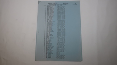
Book - Mt Beauty Voters' Roll, Shire of Bright - Voters' Roll 1979 - Mt Beauty Riding, 1979
Electoral roles list people who are registered and eligible to vote at federal, state, territory and local government elections and referenda. Prior to 1990 the rolls list voters in alphabetical order by surname and first names within each Sub-division of an electoral Division of each State or Territory. The roll is useful and interesting for family historians and the study of demographics.Electoral rolls help to locate the residential address of a person in a particular year or over a period of years. They can be used as a substitute for census records for family historians and the history of a particular place, in this case Mt Beauty. Alex McCullough was a resident of Mt Beauty and Councillor in the Bright Shire. 40 pages of firm blue paper with black typed print on one side only in 'landscape' format. Held by three staples. Each page has columns - numbered 1 to 656; Surnames in alphabetical order; Given names; Occupation; Includes L = 'land'; Address followed by Lot number in the Parish of WermatongOn the cover, top right hand corner "Cr McCullough"shire of bright; mt beauty riding; voters roll; parish of wermatong; alex mccullough -
 Kiewa Valley Historical Society
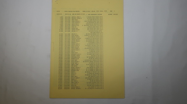
Book - Kiewa Voters' Roll, Shire of Bright - Voters' Roll 1979 - Kiewa Riding, 1979
Electoral rolls list people who are registered and eligible to vote at federal, state, territory & local government elections and referenda. Prior to 1990 the rolls list voters in alphabetical order by surnames & first names within each Sub division of an electoral division of each State or Territory. The roll is useful & interesting for family historians and the study of demographics. Alex McCullough lived in the Shire of Bright and was on its Council. Electoral roles help to locate the residential address of a person in a particular year or over a period of years. They can be used as a substitute for census records for family historians and the history of a particular place in this case the Kiewa Valley - Tawonga and Tawonga South.Approx. 60 pages of firm yellow paper with black typed print on one side only in 'landscape' format. Held by three staples. Each page has column - numbered 1 to 943; Surnames in alphabetical order; Given names; Occupation; includes L (=land). Address followed by Lot number and parish. Includes Tawonga and Tawonga SouthOn the cover on the right hand side handwritten and difficult to read - "Jack? / Indi / Benambra / Nth Eastern / Division? of Dawson / 123 Victoria Rd. / Melbourne 3000"shire of bright; kiewa riding; voters roll; alex mccullough; tawonga; tawonga south -
 Kiewa Valley Historical Society
Papers - Mt Beauty Voters' Roll, Shire of Bright - Voters' Roll 1985 - Mt Beauty, 4th July 1985
Electoral rolls list people who are registered and eligible to vote at federal, state, territory and local government elections and referenda. Prior to 1990 the rolls list voters in alphabetical order by surnames and first names within each Subdivision of an electoral division of each State or Territory. The roll is useful & interesting for family historians and the study of demographics. Alex McCullough lived in Mt Beauty and was a councillor for the Shire of Bright.Electoral Rolls help to locate the residential address of a person in a particular year or over a period of years. They can be used as a substitute for census records for family historians and the history of a particular place - in this case Mt Beauty.9 pages of firm blue paper with black typed print on one side only. Held at the top left corner with one staple. Each page has columns with 100 people listed up to 864 on page 9. surnames are in alphabetical order followed by given names and then addresses.shire of bright; voters' roll; alex mccullough; mt beauty -
 Kiewa Valley Historical Society
Papers - Kiewa Riding Voters' Roll, Shire of Bright - Voters'Rolls 1985 (May and June) - Kiewa Riding, 4th July 1985
Electoral rolls list people who are registered & eligible to vote at federal, state, territory & local government elections & referenda. Prior to 1990 the rolls list voters in alphabetical order by surname & first names within each subdivision of an electoral division of each state or territory. The roll is useful and interesting for family historians & the study of demographics. Alex McCullough lived in Mt Beauty and was a councillor for the Shire of Bright.Electoral Rolls help to locate the residential address of a person in a particular year or over a period of years. They can be used as a substitute for census records for family historians and the history of a particular place - in this case Tawonga, Tawonga South, Falls CreekMay 1985 is 7 pages; June 1985 is 9 pages of firm yellow paper with black typed print on one side only. Held by one staple at the top left hand corner. The May 1985 - Each page has columns with 100 people listed up to 628 on page 7. Surnames are in alphabetical order followed by given names and then address. June 1985 Voters Roll (Non resident) is created from Property & lists Voters No. (up to 406) Property No. Name (alphabetical) & address and are non resident voters.shire of bright; voters' rolls; kiewa riding; tawonga; tawonga south; alex mccullough; falls creek -
 Kiewa Valley Historical Society
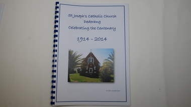
Book - Catholic Church Dederang, St Joseph's Catholic Church Dederang Celebrating the Centenary 1914 - 2014, 16th November 2014
Initially in the 1880s, services (known as stations) were held at Creamer's home in Dederang - generally x3 per year.In 1883 a small church was built where the present church now stands.This weatherboard church, St Joseph's, was replaced by a brick one in 1914 and opened on 8th Nov. 1914. The book has 9 chapters, the last one being 'Photo Gallery'. It covers the religious men, local families, newspaper snippets and records.Religion was an important part of life to people throughout the 20th century especially in a rural community as it gave people an opportunity to be part of the community and to socialize. This book gives a history of religion, of maintaining a church, of a rural community and of the Catholic religion.58 pages of printed history followed by 10 pages of colored photos in a spiral book with a blue spiral spine and a clear plastic cover. The front page includes the title in blue print with a colored photo of the church below the title.st joseph's catholic church dederang; kiewa valley; dederang families; catholic clergy; religion -
 Kiewa Valley Historical Society
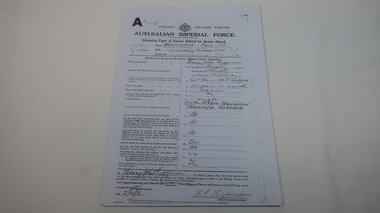
AIF Service Record of Henry John Higginson
The Higginson family farmed in the Kiewa Valley17 pages of photocopied pages from Henry John Higginson's enlistment and service history with the Australian Imperial Force (WW1)world war 1, war service, higginson, kiewa valley -
 Kiewa Valley Historical Society
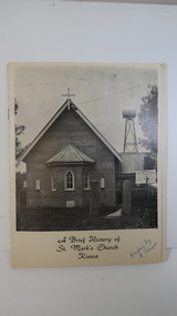
Booklet - St Mark's Church Kiewa x2, A Brief History of St Mark's Church Kiewa written by E. Temple
The Anglican Church at Kiewa. The first stone was laid on the 29th Oct. 1924. In 1879, the Yackandandah rector commenced services on Sundays in private homes in the Kiewa Valley. In 1911 Anglicans met in the Kiewa Methodist Church to elect a committee to organise financial offers and so it eventually became a vestry.The town Kiewa is in the Kiewa Valley. The church served other communities in the Valley. The book records the local populations and their commitment to religion. Cream cardboard cover with a black and white photo of the church on the front cover. It has 4 pages printed on both sides held by 2 staples. Inside there are a few black and white photos. Dated 19741. "Written by E. Temple" handwritten on the front cover 2. "C. Roper" on the front cover and inside the front cover "Clare Roper" Also, "Esther Temple" 's signature on the cover page.st mark's church, kiewa, anglican church, esther teple, thomas mitchell -
 Kiewa Valley Historical Society
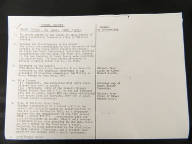
Papers - History of Mt Beauty State School No. 4644
10 points of history pertaining to the History of the Mt Beauty State School which was built in 1947 as a result of the increase in student population due to the State Electricity Commission of Victoria's construction of the Kiewa Hydro Electric Scheme. Sources sited from School records and S.E.C.V records.The papers give a detailed account of the History of the Mt Beauty State School with sources sited giving accuracy to the account.Two A3 papers with typed history of the Mt Beauty State School No. 4644 with sources sited.mt beauty. state school. state electricity commission of victoria. kiewa hydro electric scheme. -
 Kiewa Valley Historical Society
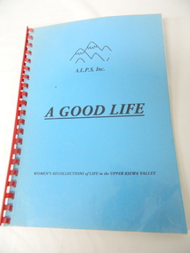
Book - A.L.P.S, A Good Life - A.L.P.S. x2, 1998
A.L.P.S. began an ongoing project to record the contribution made by women to life in the Kiewa Valley.An original history of the Kiewa Valley focusing on women from various backgrounds.A soft covered book with clear plastic cover of 81 pages with a blue cover, black written heading including A.L.P.S. Inc. logo and red plastic 'spiral' spine."Val Woinarski" & phone number inside on the first page.community group in the kiewa valley; alps -
 Kiewa Valley Historical Society
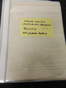
Folder - Clare Roper No. 3, Kiewa Valley Historical Records
Clare Roper was a resident of the Kiewa Valley and belonged to the Kiewa Valley Historical Society.Clare Roper collected and collated items of historical interest for Kiewa Valley Historical Society.Grey plastic with clear front cover with 9 clear plastic sleeves/pages. Includes: History of the Kiewa Valley Historical Society, office bearers, visitors book 1969-1978, life members, Tawonga Caravan Park, finances, Wallace's hut, Local history of Tawonga by C. Roper, 1949.clare roper; scrap book -
 Kiewa Valley Historical Society
Folder - Clare Roper No. 4, Early Historical Records
Clare Roper was a resident of the Kiewa Valley and belonged to the Kiewa Valley Historical Society.Clare Roper collected and collated items of historical interest for the Kiewa Valley Historical Society.Dark blue plastic with clear front cover with 11 plastic sleeves / pages. Includes: "The Discovery of the Bogong High Plains" dated 1962 from RHSV.; 'Tawonga History' dated 1964; Kiewa Valley C.W.A letter re Tangambalanga; History of the Bogong hotel at Tawonga; Memories of Wilma Roper, 1987. Yackandandah History. Ovens Crossing. Mullagong. Tawonga Hometead. clare roper; scrap book; -
 Kiewa Valley Historical Society
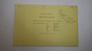
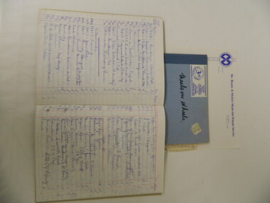
Paper Records for Mt Beauty & District Meals On Wheels, 1960s - 2003
Mt Beauty & District Meals on Wheels committee was formed on 6th Dec. 1967, possibly under the Elderly Citizens Welfare Council News (or Senior Citizens Mt Beauty) with service commencing on 16th July 1968. Volunteers transported meals from the Hospital Kitchen to the elderly and sick members of the community each day including weekends. Eventually the Shire managed the meals and roster until recent times when, in 2016, Alpine Health took over. Members of the Mt Beauty community recognised the need for meals to be delivered to the elderly and sick. They formed a committee and organised the means (rules, meals, containers, roster ) by which they could achieve their goal with volunteers and the Tawonga District Hospital. The first delivery was recorded by the press and was on film by AMV 4 Albury TV station for their local news. The official party included - local member, Tom Mitchell, Shire representatives, Alec McCullough and Dr Jean Hutching who joined the volunteers for a luncheon at the Mt Beauty Chalet.Paper records for the Mt Beauty Meals On Wheels Program includes photos, newspaper cuttings, committee documents, roster, petrol book, minute books 1983 - 1998, correspondence book, stationary and a brief history of the first delivery in 1968.meals on wheels; mt beauty; tawonga district hospital; -
 Kiewa Valley Historical Society
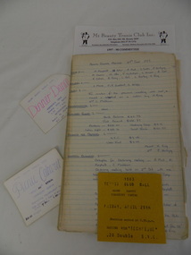
Papers of the Mt Beauty Tennis Club, 1970's onwards
The Mt Beauty tennis club was formed in the late 1940's. The number of players has varied as has the number and type of courts.Mt Beauty Tennis Club has been a part of Mt Beauty for many years involving many people. The history of the club identifies local people and the changes in the town and district regarding the popularity of tennis and tennis equipment.Paper records for the Mt Beauty Tennis Club. Minute book 1977 - 1983, 1983 - 1985, 1983 - 1990, 1991 -1999. Treasurer's book 1987 - 1996. Book tennis Competitions 1991, 1992, 1993, Rules and loose papers 1980's - 2006 and 3 types of cards Dinner Dance at the Workmen's Club, Picnic Cabaret at the Community Centre, and 1983 Tennis Club ball at Community Centremt beauty; tennis club; sport -
 Kiewa Valley Historical Society
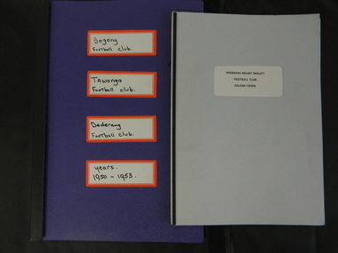
Paper Collection of Football Clubs of the Upper Kiewa Valley, 1940s onwards
Tawonga's first recorded game was against Yackandandah in 1893 at Tawonga. Tawonga folded up in 1957 enabling Bogong to have 2 teams, the firsts and seconds in 1958. Bogong merged with Dederang in 1976 and became the Dederang-Mt Beauty Football Club. Bogong joined the Yackandandah league in 1947. In 1954 Bogong entered the Ovens & King League. In 1960 Bogong United was in the Tallangatta League with Tallangatta, Kiewa, Kergunyah, Dederang, Lavington, Bandiana, Bullioh, Mitta United, Barnawartha, Sandy Creek and Yackandandah. The Kiewa league was formed in 1923. In the 1930's Tawonga was in the Chiltern League then the Dederang League, then the Yackandandah League and then the Tallangatta League.The papers are a primary source of the history of the Bogong, Tawonga, Dederang and Mt Beauty Football Clubs. They include family names of players and families living in the Kiewa Valley at the time and increase an understanding of the social changes country areas have undergone during the period covered.Paper records for local (Upper Kiewa Valley) football clubs' history including minute books, notes, journals, newspaper cuttings, footy records and booklet produced for the Dederang-Mt Beauty Golden Jubilee in 1998.football clubs; upper kiewa valley; sport -
 Warrnambool and District Historical Society Inc.
Document, Map: Lady Bay 1853, 1853
This is one of the earliest surveys and maps of Warrnambool harbor, Lady Bay. Being done in 1853, it shows the depths of the bay area marked in fathoms, currents and directions and areas of rocks around mouth of the Merri and the Western side of the bay as well as a large sand spit to the middle right of the beach region.. It also marks the large areas of seaweed and fuci in the outer bay area. It has the area of Pertobe Lagoon marked and shows the early tracks to the town. The engraving work was done by Tulloch and Brown, with Tulloch being one of the earliest engravers and lithographers in the state of Victoria. He arrived in Melbourne in 1849 and set up business with James Davie Brown in 1853 with Brown being a map engraver. They were awarded bronze and silver medals for their work at the Victorian Industrial Exhibition. He also worked in the vignettes on the Proeschel Map of Victoria.This map is of high historical and comparitive significance as it shows the Lady Bay area prior to the changes that have occurred in the last 160 years with the building of the breakwater. The issue regarding access to Lady Bay remains a current one. The engraver D Tulloch engraved some of the earliest scenes of the goldfields in Ballarat and as such has left a record of a very early and important era in Australian history. Rectangular cream paper with black text. Map area is outlined by fine black lined border. Key in top right hand corner and scale at bottom middle of map.Map is labelled Town of Warrnambool printed at top of map. Small logo at top right corner which has “Hydrographic Department” in circle around an anchor. Lady Bay Warrnambool Surveyed by John Barrow assistant surveyor Engraved by Tulloch & Brown in bottom right corner. Melbourne engraved by order of the legislative Council of Victoria in middle bottom.map, warrnambool, town of warrnambool map 1853, tulloch & brown map 1853, lady bay warrnambool,, warrnambool harbour, warrnambool breakwater, warrnambool beach -
 Warrnambool and District Historical Society Inc.
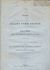
Document, Allan’s Ford Bridge 1852, 1852
This is an original Victorian Government document containing the printed version of 37 reports and letters regarding the building of the first Allansford bridge completed early in 1852. The correspondence dates from October 1850 to February 1852 and includes letters and reports from Melbourne Government employees such as Robert Hoddle, Chief Surveyor, David Lennox, Superintendent of Bridges and Lieutenant – Governor Charles La Trobe. The correspondence from local settlers included the names of William and John Allan, John Davidson and James Coulstock. The correspondence shows that some settlers in the Warrnambool/Port Fairy district wanted a portion of the Government allocated funds spent on the local roads and bridges in other locations. The 1852 Allansford bridge cost £480 and was replaced in 1870. This document has strong historical significance as it relates to one of the earliest State government works in the district and records the public imput into the decision.. It contains opinions and correspondence between a number of early settlers in the district at the time.Grey/blue paper document with black text. 21 pages plus 4 page index at back.allan's ford 1852, allansford bridge, allansford, history of allansford, warrnambool -
 Warrnambool and District Historical Society Inc.
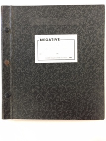
Photo, Negatives Pioneers of Warrnambool & District board, 1975
The following extract written by Karen Tyers Warrnambool Family history group explains the journey and background of the Warrnambool Pioneer Board. Warrnambool is fortunate to have a photographic record of some of its pioneers. They are commemorated on the Pioneers’ Board. The Pioneers’ Board with its elaborate frame measures approximately 2 metres by 3 metres and holds 204 photographs of Warrnambool’s early pioneers. In 1907 Edward Vidler, secretary of the Warrnambool & District Progress League and Chamber of Commerce and Industry, invited descendants of those who arrived in Warrnambool before 1860 to send photographs of their pioneer ancestors to commemorate the Diamond Jubilee of Warrnambool’s foundation in 1847. A charge of £1 for each photograph was set. Lillian Foyle of Foyle’s photographic studio, was engaged to colour the photographs and undertake the associated artwork. By December 1907 the honour board was on exhibition in Bernard’s Gallery, Melbourne. Unfortunately Vidler left Warrnambool in 1907 with the honour board expenses unpaid. The Progress League refused to take responsibility for the debt and the honour board remained with Foyle’s Studio for 17 years. In 1922 subscriptions were called for and £43 16s 6d was acknowledged. After a final determined effort was made in 1924, the £100 debt was collected and Charles Foyle, Lillian’s brother, accepted settlement of the debt. On 2 May 1924 the honour board was moved from Foyle’s Studio to the Art Gallery. For many years the honour board was in the entrance passage to the public library. After the library was demolished in 1975 the pictures were removed to the Art Gallery where it was restored by the Director of the Art Gallery, Jack Welsh. The board was later stored in an empty front room at Murweh and the dismantled frame stored in an outbuilding. By 1982 the honour board was in the foyer of the City Council offices. During the renovations of the interior of the council offices in 1997 the honour board was moved to the library where it remained until moved to HeritageWorks in March 2014. For a full list of names go to http://www.warrnamboolhistory.org.au/warrnambool-history/pioneers-board/ The Warrnambool pioneer Board is one of those rare items which can claim significance on most if not all of the primary and comparative significance criteria. As a collection of early pioneers in the district it provides a valuable resource for historians and researchers. It gives light to a social scene in the district much of which can be verified from diaries and other items held by the historical society and also available on websites such as Trove. It has relevance to this day with many family historians enquiring of people included on the board. The collation of the board is a story of great interest in itself. While there are images of 204 men on the board the only reference to a woman is Lillian Foyle the artist who was responsible for much of the artistic work on the board. It compares well in size and quality with a number of montages, and collations of images from around the state of Victoria. It is by no means a complete list of pioneers of the district but there are many well- known ones included. They come from a wide range of backgrounds and as such presents a cross section of our earliest settlers in the district from 1840's to 1860’s.Cardboard folder with black and grey mottled cover with 3 metal studs along spine and white paper label with the word negative printed in black on front cover. Inside is a printed index of pioneers with reference relating to board number and negative number. There are three loose strips of negatives and 20 pages with pockets to hold strips of negatives. Up to page 13 have negatives strips inserted. There are 15 large and one small print of some of the pioneers from the board.This negative album was prepared by John A Welsh MBE JP Dip M Eng Director Warrnambool Art Gallery 1/7/1975 to 11/12/1977.There are a number of grey lead notations possibly corrections against some of the names in the index.warrnambool, warrnambool pioneer board, jack welsh, warrnambool art gallery, pioneers of warrnambool, foyles photography, lillian foyle, bernard framers, w mcaree, -
 Warrnambool and District Historical Society Inc.
Administrative record - Jill Heathcote Album and Folder, Jill Heathcote, Dennington, Jill Heathcote Collection, Second half of 20th century
The album is a collection of items of interest, mainly newspaper cuttings, from 1982, 1983 and 1984. The folder contains information and records relating to the Warrnambool Bird Observers' Group and includes records relating to Lake Pertobe, Tower Hill, The Maam, Kelly's Swamp, Nirranda, Allansford, Timboon, and Port Fairy. They were collected by Jill Heathcote (1927-2011), a Dennington resident who was for many years a member of the Warrnambool and District Historical Society, the Warrnambool Bird Observers' Group and the Warrnambool Field Naturalists Group. The cuttings and bird records reflect her interest in both local history and natural history. These two items are of considerable interest, particularly to those interested in local natural history. The scanning of the items has been completed.1. One brown plastic folder sold commercially for the storage of photographs and documents. The cover has an ornamental gilt border. The folder contains 24 cardboard pages and plastic sheets. The pages are bound with two metal screws. There are 77 items stored in this folder, most of them being newspaper cuttings dealing with natural history from 1982-3-4. The collector of the items in the folders was Jill Heathcote. 2. Black folder containing handwritten notes, articles, charts and typed listsjill heathcote, natural history, warrnambool -
 Warrnambool and District Historical Society Inc.
Book, Hodder and Staughton, The New Testament, 1934
The new testament is the second part of the Bible and records the teachings of Christ through the four gospels as well as the Acts of the Apostles and letters of St Paul as well as book of Revelations. It is commonly used as a book of inspiration and study within all Christian Churches. This particular copy was presented to James Cook in 1940 by the Hamilton Church of Christ Sunday School. The Cook family was also connected with the Warrnambool Church of Christ.This item has only a tenuous connection to Warrnambool and its history but is retained because of its connection to the Cook family.Dark grey cloth covered card cover with symbol of lamp in circle on front cover. Title in red on spine of book.388 pagesPresented to James Cook from the Church of Christ Sunday School Hamilton February 1940warrnambool, church of christ sunday school, james cook, -
 Warrnambool and District Historical Society Inc.
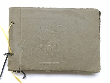
Book, Scrap Book, Circa 1930
This album contains photographs of many local and beach scenes such as view over Warrnambool, Botanic Gardens, Hopkins River and Bridge, Warrnambool railway station, Proudfoots, Thunder Point, Christ Church and the War Memorial. There are a couple of photographs of groups of people picnicking on the main beach. The newspaper cutting showing firemen dousing the last of the flames of the fire has onlookers including four children in the foreground. The Ozone Coffee Palace was built in 1890-1891 and burnt down February23, 1929. It was one of the largest fires in Warrnambool It was designed by Mr J McLeod. It was grand in design and decoration. The term Coffee Palace was used to describe temperance hotels which were built during the 1880’s -1890’s. They typically were multi-purpose and had a large number of rooms for ballrooms and leisure activities. Coffee palaces were aimed at families in coastal areas and inner city locations. Examples of some are The Windsor Hotel Melbourne, Ozone, Queenscliff and Kilbreda Convent in Mentone. This album has social and historical significance as it shows a collection of local scenes which is a record of familiar scenes such as the gardens, Hopkins River and beach scenes. The groups of people are unknown but the images provide a snapshot of customs and costumes of the early 1920’s.Khaki coloured soft card tied with a dark green cord which has broken and has been replaced with yellow string. There is an embossing of a lion/dragon on front cover with ribbons. 20 pages with photographs glued to most. A cutting relating to the fire at the Ozone mansions is inside the front cover.warrnambool history, early warrnambool photographs, ozone coffee palace -
 Warrnambool and District Historical Society Inc.
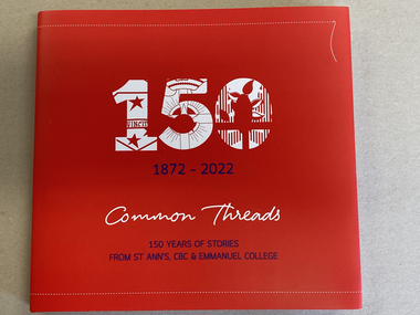
Book, 150, 1872-2022 Common Threads 150 Years of Stories From St. Ann's, CBC, & Emmanuel College, 2022
... interest as it records the history of Emmanuel College, a prominent ...History of Emmanuel College and its founding schoolsThis is a book of 220 pages with a red cover in blue and white printing and white and red graphics. It has a dust cover replicating some of the pattern of the hard cover. The pages contain printed text, black and white and coloured photographs and other illustrations. There is a loose book mark with the printing replicating the cover. non-fictionHistory of Emmanuel College and its founding schools catholic education in warrnambool., history of emmanuel college, st ann's, christian brothers college, emmanuel college warrnambool