Showing 659 items matching " survey plan"
-
 Rutherglen Historical Society
Carlyle Cemetery Map, Plan of Wesleyan Compartment, 1952
This is a map produced to attempt to bring order to the cemetery. Originally the layout was not well defined and it is difficult to use this plan to locate a particular grave, also the fact that not all graves are marked and foot paths are not defined has exacerbated this issue. Photocopy, White paper, black printing, black line work showing lot and compartment boundariesReferences Grid Survey points at 50 feet centres shown (as a cross with the reference mark number in brackets) Lot Number shown at left side of graves. Burial Number shown at right side of grave. Lots with unidentified burials show with dashed cross with in the lot. topographic survey, cadastral survey, carlyle cemetery, burials, graves, lot boundary, rotunda -
 Ballarat Heritage Services
Digital photograph, Graveyard Reserve, Ballarat East
Ballarat East, Section 103, Allotment 21 & 22, Peake and Tress Streets, Mount Pleasant. Surveyed by W. S. Reeves Contract Surveyor April 14th, 1871. Also shows allotments of T. Williams and F. Macalpin, as well as the Powder Magazine Reserve.Plan of the Graveyard Reserve and Mount Pleasant Powder Magazine.mount pleasant, w.s. reeves, plan, powder magazine, t. williams, f. macalpin -
 Ballarat Heritage Services
Document - Report, McDougall and Vines Conservation and Heritage Consultants, Sturt Street Gardens, Ballarat, Victoria Conservation and Landscape Management Plan, 2007, 07/2007
Ballarat's Sturt Street has its origins in W.S. Urquhart's survey of 1851. A generous reserve was allocated for the main streets of Ballarat, of which Sturt Street was the first. In the 1860s Sturt Street was planted with blue gums, with a dual carriageway and central median strip installed. Bandstands ere soone erected, including the Queen Alexandra Bandstand (1908) and the Titanic Memoria Bandsatnd (1915).PDF of a report on the Sturt Street Gardens, Ballarat.sturt street ballarat, conservation management plan, sturt street gardens, landscape management plan, statue, gardens, bandstands, infrastructure, city of ballarat report -
 Unions Ballarat
Scrapbook: Ballarat Trades Hall newspaper clippings 1988-1996, The Courier
1a. Jobless muddle: Ballarat leaders say local survey closer to mark than Govt's 'drastic underestimate' 1b. Local community leaders reject Govt's unemployment figures Paper: The Courier Date: 15 November 1991 2. Ballarat must change industry base: Shearer - Reliance on wool and wheat now redundant Paper: n.a. Date: 14 November 1991 3.Lay-offs plan sparks strike [Ballarat] Paper: The Courier Date: 13 November 1991 4a. Ballarat makes pleas to Hawke: Help us beat jobless problem 4b. Help us create jobs plea to Canberra Paper: The Courier Date: 8 November 1991 5. Ballarat to plead for its life Paper: The Courier Date: 8 November 1991 6. Disunity blasted: Council bickering 'sabotaging local economy' [Ballarat] Paper: The Courier Date: 9 May 1992 7. Hand cuts migrant intake: Ballarat Trades Hall welcomes cut Paper: n.a. Date: 13 May 1992 8. School leavers 'missing out' Paper: The Courier Date: 18 May 1992 9. 10,000 in rally over government assets sale Paper: n.a. Date: 8 July 1992 10. Unions seek views on amalgamation [Ballarat] Paper: The Courier Date: 30 May 1992 11. Jobs plan hailed: Local leaders say it'll help young jobless [Ballarat] Paper: The Courier? Date: 26 June 1992 12. Youth wage gets mixed reaction [Ballarat] Paper: The Courier Date: 7 July 1992 13. Plans to axe tariffs are 'frightening': Shearer [Ballarat] Paper: The Courier? Date: 11 July 1992 14. Asbestos scare at primary school [Ballarat] Paper: The Courier Date: 11 July 1992 15. Ballarat protest: 5000 rally against the Kennett Govt Paper: n.d. Date: 11 November 1992 16. The Ballarat strike (pictures) Paper: The Courier Date: 11 November 1992 17. Train services under threat, warns union [Ballarat] Paper: n.a. Date: n.d. 18. Shearer slams new WorkCare Paper: n.a. Date: 5 November 1992 19. Ballarat unions back strike against Govt Paper: The Courier Date: 7 November 1992 20. Youth late night lolly selling may be both risky and illegal [Ballarat] Paper: The Courier Date: 5 December 1990 21a. 500 Ballarat jobs 'at risk' 21b. Tariff cuts will hit Ballarat jobs Paper: The Courier Date: 5 December 1990 22. Govt blueprint to hit local industries [Ballarat] Paper: The Courier Date: n.d. 23. AHA wage move rejected: Pay rise offer in place of penalty rates [Ballarat] Paper: The Courier Date: 9 July 1991 24. City shops leave Sunday to big stores [Ballarat] Paper: n.a. Date: 18 July 1991 25. Union dispute threat to Base [Ballarat] Paper: n.a. Date: 23 July 1991 26. Metalworkers agree on wages: Unions call on IRC to accept agreement Paper: The Courier Date: 19 July 1991 27. Ballarat bakery fears price war Paper: n.a. Date: 28 June 1991 28. Ballarat CES in Newstart bans Paper: n.a. Date: 29 June 1991 29. No Sunday trading: rally seeks support Paper: The Courier Date: 29 June 1991 30. The re-emerging Trades Hall belong to all workers [Ballarat] Paper: The News Date: 15 September 1988 31. Work safety better: TLC [Ballarat] Paper: n.a. Date: 15 September 1998 32. Black ban on bank [Ballarat] Paper: n.a. Date: 28 February 1989 33. BTLC slams Stockdale Workcare 'rort' claims Paper: n.a. Date: 11 May 1989 34. BTLC backs luxury surcharge plan [Ballarat] Paper: n.a. Date: 24 June 1989 35. Strike ends at John Valves [Ballarat] Paper: n.a. Date: 21 June 1989 36. Unions need a better image: 'Future is linked to intensive education process' [Ballarat] Paper: n.a. Date: n.d. 37. Ballarat protest against Govt: Teachers vow to fight Govt Paper: The Courier Date: 3 December 1992 38. Cleaners vote not to take industrial action [Ballarat] Paper: The Courier Date: 3 December 1992 39. Nurses stop work [Ballarat] Paper: The Courier Date: 3 December 1992 40. Amcast to close: Up to 140 will be made redundant [Ballarat] Paper: n.a. Date: 5 December 1992 41. Ronaldson hits out at union's 'fear campaign' [Ballarat] Paper: n.a. Date: 5 December 1992 42. Reprieve for Amcast workers [Ballarat] Paper: n.a. Date: n.d. 43. Workers take levy protest to Traynor [Ballarat] Paper: n.a. Date: 10 December 1992 44. Unions claim 2000 jobs lost in 12 months [Ballarat] Paper: The Courier Date: 6 October 1993 45. Unions plan on strong show [Ballarat] Paper: n.a. Date: 28 November 1992 46. Union rally to blast WorkCover [Ballarat] Paper: n.a. Date: 17 July ? 47. 1800 unionists in action day [Ballarat] Paper: n.a. Date: 1 December 1992 48. Protest at Lakeside stops work [Ballarat] Paper: n.a. Date: 1 December 1992 49. Ballarat urged to fight Amcast closure Paper: n.a. Date: 7 December 1992 50. Big crowd expected at deficit tax rally [Ballarat] Paper: n.a. Date: 12 December 1992 51. Trade unions: Recruit drive in Ballarat Paper: The Courier Date: 14 September 1995 52. Church and union unite for protest [Ballarat] Paper: n.a. Date: 14 September 1995 53. Ballarat strike tomorrow Paper: n.a. Date: 15 December 1992 54. Govt accuses striking unions of 'thuggery' Paper: n.a. Date: 15 December 1992 55. Hundreds support rally [Ballarat] Paper: n.a. Date: 14 December 1992 56. Disagreement on new Fightback package Paper: n.a. Date: 19 December 1992 57. Unions boycott public rally [Ballarat] Paper: n.a. Date: 19 December 1992 58. Group aims to fight deficit levy [Ballarat] Paper: n.a. Date: 21 December 1992 59.42 jobs go at workshops, more cut backs feared Paper: The Courier Date: 24 December 1992 60. ALP against levy: Devereaux Paper: The Courier Date: 3 February 1993 61. Rail workers fight for jobs [Ballarat] Paper: n.a. Date: 6 January 1993 62. Trams and buses to be disrupted [Ballarat] Paper: n.a. Date: 6 January 1993 63. Brown snubs rail talks [Ballarat] Paper: n.a. Date: 6 February 1993 64. Deficit levy is causing hardship: Trades Hall [Ballarat] Paper: n.a. Date: 5 February 1993 65. Ballarat unions to rally on March 1 Paper: n.a. Date: 5 February 1993 66. Angry rail workers plan to see Brown [Ballarat] Paper: n.a. Date: 8 January 1991 67. Sharing the secrets of the camera Paper: The Courier Date: 6 February 1993 68. Councils must unite: Shearer [Ballarat] Paper: The Courier Date: 9 February 1993 69. Shearer hits Lib health policies Paper: n.a. Date: 11 February 1993 70. Worker injury costs 'shifted' to taxpayers [Ballarat] Paper: n.a. Date: ? June 1993 71. Shearer warns on contracts Paper: n.a. Date: 5 February 1993 72. Ballarat hurting, says union chief Paper: n.a. Date: 22 February 1992 73. Workers will back protest, says Shearer [Ballarat] Paper: n.a. Date: 22 February 1992 74. Shearer gives Govt a blast on 'sacrifice' Paper: The Courier Date: 17 February 1993 75. Shearer supports strike [Ballarat] Paper: The Courier Date: 1 March 1993 (?) 76. Workers may be 'scared off" rally [Ballarat] Paper: n.a. Date: 1 March 1993 77. Workers at risk: Shearer Paper: n.a. Date: 25 February 1993 78a. 3000 marchers in protest against Kennett policies 78b. Marchers in street protest [Ballarat] Paper: The Courier Date: 2 March 1993 79. 'Jobs threat from Libs tariff plan' [Ballarat] Paper: The Courier Date: 2 March 1993 80. Students, staff rally in protest at govt cuts Paper: The Courier Date: 6 October 1993 81. Hurt workers live on $50 a week: union [Ballarat] Paper: n.a. Date: ? July 1994 82. Workers in protest at injury benefits [Ballarat] Paper: The Courier Date: 24 July 1994 83. Contracts need an 'even hand' [Ballarat] Paper: n.a. Date: ? July 1993 84. 2000 rally against public service cuts [Ballarat] Paper: n.a. Date: 6 May 1993 85. Telstra cuts threatening 100 Ballarat jobs: union Paper: n.a. Date: ? ? 1996 86. Workers to fare worse under Libs - Hubbard [Ballarat] Paper: n.a. Date: ? ? 1996 87. Ballarat workers to protest against industrial changes Paper: The Courier Date: n.d. 88. Meet Telstra, unions urge development body [Ballarat] Paper: n.a. Date: ? July 1996 89. Threat seen to part-time job security [Ballarat] Paper: n.a. Date: 6 July 1996 90. Trades Hall gears up for big battle [Ballarat] Paper: n.a. Date: ? July 1996 91a. Workers in city protest 91b. Workers in city protest Paper: n.a. Date: 31 August 1996 92. Unionists urged to fight hard for rights Paper: n.a. Date: 31 August 1996 93. Unpaid work trials a trap: Shearer Paper: The Courier Date: 9 November 1996 94. CES union action 'minor' Paper: The Courier Date: 9 November 1996 95. Sawmill row looks likely to escalate Paper: The Courier Date: 9 November 1996Significant collection of press articles that include comment from Unions Ballarat Secretary, Graeme Shearer, around the period when Jeff Kennett (Liberal Party Victoria) was premier of Victoria. Focus upon a variety of social and industrial issues impacting the Ballarat region.Scrapbook - news clippings.btlc, ballarat trades and labour council, industrial relations, industrial action - strikes, kennett jeff, liberal party victoria, victorian railways, australian labour party - alp, oh&s, unemployment - ballarat -
 Robin Boyd Foundation
Letter, Harold Lander to Robin Boyd and others. (Crawford Productions), 23.11.1967
Memo from Harold Lander, providing background information for a planning meeting to be held to discuss ‘Hunter’ television series. 'Hunter' is an Australian spy drama which ran from 4 July 1967 – 5 March 1969 on Nine Network. Lander writes about considerations for making the show commercially successful including publicity tactics. Robin Boyd is mentioned on page 9. Lander asks for his suggestion on a new set design for the Independent Surveys office for the show.Crawford Productions and Robin Boyd also explored ideas for other television productions, besides the successful 'The Flying Dogtor" series.Typewritten, carbon copy, foolscap, 11 pages.Black pen mark up on pages 1-9, red pen mark up on pages 1 and 2.hunter, australian television, crawford productions, homicide, nine network -
 Southern Sherbrooke Historical Society Inc.
Information folder - Glen Park
... , showing proposed development. -A1 sheet, Plan of feature survey..., showing proposed development. -A1 sheet, Plan of feature survey ...Folder containing information pertaining to the history of Glen Park homestead, Menzies Creek. Contents: -two pages photocopied from "That Little Train" by Peter Cuffley, showing four photos of Glen Park homestead and a short history of Edwin Johns at Glen Park (2 copies of each) -articles, "No. 861's full steam ahead again", photo shows Col Rees with Coonara Community School students, and "Living the dream" re. engine no. 861. On verso, "A Family Reunited", article by Emerald Tourist Railway re. locomotives, and "Colin just loves steam locomotion" re. engine no. 861. -4 letters, from Puffing Billy Railway, in support of Col Rees. -Letter, dated 19 June 1996, from Emerald Tourist Railway, re. appeal for restoration of Garratt engine. On verso, copy of certificate awarded to Col Rees for donation to appeal. -Letter, 1 June 1998, re. Garrett appeal. On verso, certificate awarded to Col & Kellie Rees for donation to appeal. -Aerial photo showing proposed property boundaries of Glen Park subdivision. -Aerial photo showing existing property boundaries of Glen Park. NB. last four items provided to society by Col Rees in support of subdivision. -Memorandum dated 2 May 2000 from Graham Whitt, Shire of Yarra Ranges, to Shire Service Centres, re proposed division of Glen Park land. -Fax, dated 13 June 2000, from Southern Sherbrooke Historical Society to Shire of Yarra Ranges, re. intention to make submission. -Letter, dated 14 June 2000, acknowledging receipt of above fax. -Submission, dated 18 June 2000, from Southern Sherbrooke HS, expressing concern re. proposed subdivision of Glen Park. -Fax, dated 27 June 2000, from Dianne Kueffer to Susan Heywood-Downard, Agenda Item 2 of the Yarra Ranges Planning Committee Agenda 14 March 2000, including detailed description of proposed subdivision and map. -Letter, dated 7 July 2000, Shire to Society, re. discussion of Glen Park subdivision by council. -Letter, dated 7 July 2000, Society to Shire, re. withdrawal of objection subject to certain conditions. -Letter, dated 14 July 2000, Shire to Society, re. council resolution to allow subdivision of Glen Park. -Letter, dated 24 October 2000, Shire to Society, stating that amendment to Planning Scheme allowing subdivision was approved by council and gazetted on 19 October 2000. -seven A3 sheets, showing house and property plans for new constructions proposed for Lot 1 of Glen Park subdivision. -diagram, hand-drawn (by Col Rees?) on lined A4 sheet, showing proposed development. -A1 sheet, Plan of feature survey of Lot 2 Blackhill Rd, Selby, dated 12 April 2000, showing contours, vegetation, proposed location of buildings, etc. -Glen Park Homestead and Cyprus Avenue, document prepared for the Shire Of Yarra Ranges by Helen Lardner Conservation & Design P/L, June 2003edwin johns, breen family, col & kellie rees, puffing billy -
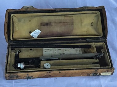 Queenscliffe Maritime Museum
Instrument - Planimeter in leather box
This planimeter in leather box was used by P. J. Larkin, government surveyor, for measuring irregular areas in plans and charts. This type of instrument is still used today and is useful for computing dredging volumes.Surveyor active in the 20s and 30s in Port Phillip and QuennscliffA Planimeter in its own leather box.The Adams Engineering Co. Wellington N.Z. No 8747surveying instruments, p j larkin -
 Bendigo Historical Society Inc.
Document - WHITE HILLS BOTANIC GARDENS, BENDIGO: HERITAGE SIGNIFICANCE ASSESSMENT AND STRATEGY PROJECT
Four hundred and forty three page report titled 'White Hills Botanic Gardens, Bendigo - Heritage Significance Assessment and Strategy Project by Lee Andrews & Associates Heritage Consulting, dated 31 October 2006. Contains History of White Hills Botanic Gardens, Physical Survey ad Analysis, Comparative Analysis, Analysis and Assessment of Cultural Significance, Developing the Conservation Policy, Conservation Policy, Conservation Guidelines, Conservation Actions,References and Appendices. Also contains a number of photos, copies of plans and documents, and a plan of the area with the trees marked and identified.document, white hills botanic gardens bendigo - heritage significance assessment and strategy project, bendigo historical society, jim evans, tim buykx, greater bendigo city council, lee andrews & associates heritage consulting, bendigo advertiser, the bendigonian, bendigo independent, argus, bendigo homes and property, mal gregory, mitch kemp, anthony sheean, casey ely, vicki johnson, sandra crump, friends of bendigo's botanic gardens, jane cleary, judy milner, jan orr, heritage victoria, john hawker, department of sustainability and environment historic places, norm stimson, bill dundas, janette hodgson, royal botanic gardens melbourne, roger spencer, university of melbourne burnley campus, greg moore, goldfields research centre, bendigo library, vivien newton, rita hull, state library of victoria, matheson library monash university, mueller correspondence project, sara maroske, library of the royal botanic gardens melbourne jill thurlow, helen cohn, gwen pascoe, john dwyer, larritt and russell -
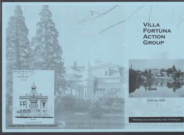 Bendigo Historical Society Inc.
Document - FORTUNA COLLECTION: VILLA FORTUNA ACTION GROUP
Blue tri-fold pamphlet titled 'Villa Fortuna Action Group' which has a photo of Fortuna and the lake on the front with Fortuna 1908 under the photo and Working for Community Use of Fortuna. On the inside is a brief history of Fortuna, What the Action Group plans to do and Potential Activities. There is also a photo of the Billiard Room, criteria 1908 and another of the exterior of the building. There is also a space to fill in for a Joining Fee and Annual Membership Fee of $10 each. On a lighter photo on the back page is a proposed drawing of the Entrance Hall.bendigo, clubs, villa fortuna action group, fortuna, army survey regiment, theodore ballerstedt, vahland, getzschmann, 180 mine, george lansell, roman bath, pompeii fountain, department of defence, the villa fortuna action group, bendigo historical society inc. -
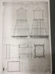 Queenscliffe Maritime Museum
Plan - Plan for a tide gauge house
An extract from the Board of Land and Works building estimates for 1858 shows an allocation of 500 Pounds for the construction of Tide Gauge Houses at various places. A copy of this plan was obtained from the Hydrographic Survey Office in Queenscliff. https://www.parliament.vic.gov.au/papers/govpub/VPARL1857-58NoB1.pdfCopy of a plan for a tide gauge house at Queenscliff 1858Clerk of works office Geelong 27 July 1858queenscliff, tide gauge house, plan -
 Bendigo Historical Society Inc.
Document - PETER ELLIS COLLECTION: LETTER, 4th October, 1976
Letter, dated 4/10/1976 from Diana R. Collier, Hon. Secretary, The Bendigo Field Naturalists Club to The Minister for Lands, The Hon. W. A. Borthwick making an application to have a reserved area for the preservation of native flora and fauna near the Quarry Hill Golf Club. Features, fauna and flora are mentioned including an original Boundary Stone and the Fairy Waxflower (Eriostemon verrucosus) also known as the Bendigo Wax Flower. Included is a list of birds (including some that nest in the area sometimes) and plants.communication, postal, letters, peter ellis collection, the bendigo field naturalists club, proposed boyd st nature reserve, the hon w a borthwick, recreation reserve extension (rs 3458), cemetry reserve extension (rs 3777), rubbish depot (rs 5980), education purposes reserve, (rs 6402), j willis, bendigo city council, city boundary stone, regel, quarry hill golf club, canberra botanical gardens, stony ridge flora reserve sydney, kings park perth, maranoa gardens melbourne, kaweka sanctuary castlemaine, central and northern branch of the national trust, school sanctuary (quarry hill), education dept, society for growing australian plants - bendigo group, lawn cemetery, bendigo city council parks and recreation dept, bendigo trust afforestation committee, quality of life action group, ackhurst plan, winifred waddell estate, dept of crown lands and survey, ministry for conservation, mr g edwards, mr m goode, mr j chellacombe, diana r collier -
 Bendigo Historical Society Inc.
Document - MCCOLL, RANKIN AND STANISTREET COLLECTION: SUNDRY REPORTS, 1930's
Manilla Folder containing reports from various mines in Bendigo and surrounding areas. 1. 4 page typewritten report on the Balaclava Hill Mine at Rushworth and some newspaper clippings about the mine with a plan of the underground workings; 2. Page from the Árgus' dated 2nd August 1900 featuring an article on the survey of the Garden line of Reefs; 3. 5 page report with maps on the Tooleen Gold Field; 4. Single page report about an unnamed mining area claimed to be on the southern end of the Deborah line of reef. (this could be the 'Three Jays' mine in Sedgwick. P. Wilkin); 5. Hand written report on the Coronation Mine, 2 miles east of Walhalla.; 6. Hand written report dated 1935, of the Queen Mary mine, St. Arnaud.; 7. 1932 report on the North Neangar lease.; 8 4 page report on the Kings Prize Gold Mining Syndicate.; 9. Description of the plant of the Marong Alluvial Company? Also a guide for marking out leases.; 10. Crushing details (1 page) from the 'Enterprise' Mine South of and adjacent to Perseverence.; 11. 1 page crushing details from Rowe Brothers, Mosquito Mine, Fryerstown.; 12 hand written report mentions Arthur Hatfield, Scarsdale.; 13. Map with lines of reef showing the position of the New Moon Consolidated and the New Moon United shafts.; 14, Large scale map from Harrison/Victoria street to Havilah Road showing the positions of the Carlisle, North Garden and Unity Shafts.gold mining, miners' safety cage, sundry reports, mining. bendigo, rushworth, balaclava hill, garden line of reef, toolleen, coronation mine, walhalla, queen mary mine, st. arnaud. north neangar, kings prize gold mining syndicate, marong, enterprise mine, perseverence, rowe brothers, mosquito mine, fryerstown, arthur hatfield, scarsdale, new moon consolidate, new moon united, carlisle, north garden, unity. -
 Bayside Gallery - Bayside City Council Art & Heritage Collection
Map, Department of Crown Lands and Survey et al, Moorabbin, County of Bourke, Government Roads, 1920
The cadastral map of the Parish of Moorabbin in Victoria (L.6104) shows parish boundaries and land ownership 1920 when Sandringham was a Town. The government roads have been coloured in red pencil.moorabbin, county of bourke, map, plan, land subdivision, land titles, foreshores, hampton, beaumaris, highett, cheltenham, department of lands and survey, land owners, cartographic material, brighton, sandringham, town of sandringham, government roads -
 Bayside Gallery - Bayside City Council Art & Heritage Collection
Map, Department of Lands and Survey, Land under the control of the City of Sandringham, 1962
The cadastral map showing land under the control of the City of Brighton in 1962.map, plan, foreshores, sndringham, hampton, beaumaris, cheltenham, department of lands and survey, cartographic material, moorabbin, black rock, street map, city of sandringham, board of lands and works -
 Bayside Gallery - Bayside City Council Art & Heritage Collection
Map, Department of Crown Lands and Survey, Moorabbin, County of Bourke, c. 1918
The cadastral map of the Parish of Moorabbin in Victoria (L.6104) shows parish boundaries and land ownership c. 1918 when Sandringham was a Borough.moorabbin, county of bourke, map, plan, land subdivision, land titles, foreshores, sndringham, hampton, beaumaris, highett, cheltenham, department of lands and survey, land owners, cartographic material, borough of sandringham, brighton -
 Bayside Gallery - Bayside City Council Art & Heritage Collection
Map, Department of Crown Lands and Survey, Melbourne and Suburbs, City of Sandringham, 1917-1926
map, plan, foreshores, sndringham, hampton, beaumaris, cheltenham, department of lands and survey, cartographic material, borough of sandringham, moorabbin, black rock, street map, city of sandringham -
 Bendigo Historical Society Inc.
Map - Marong County of Bendigo
Map of Marong. Drawn and reproduced at the Dept. of Lands and Survey, Melbourne. By authority: W.M. Houston Government Printer. June 1953.On the back in blue pen: certified plan parish Marong, signed minister and seal affixed for land S sec.72 evidence act. I certify that this a true plan parish Marong (signature illegible) minister for lands.map, marong -
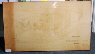 Bendigo Historical Society Inc.
Map - CONTOUR PLAN OF THE GOVERNMENT CAMP SANDHURST 1854, 1994
Contour map (copy) of the Government Camp Sandhurst, 1854. Map is mounted on coreflute and laminated. Written in bottom righthand corner 'Contour Plan of the Government Camp, Sandhurst. Dec 1854. Signed by Richard Larritt, Assistant Surveyor, 11th December 1854.' Shown on map: Pall Mall, Bendigo Creek, Commissioner's Gully, View Place (now View Street), Post Office, Bank of Victoria, District Surgeon, Sandhurst Fire Brigade, Police Hospital, Flagstaff, Gold Office, License Shed, Military Barracks, Stables, Commissioner's Buildings, Police Office. Old Cemetery, Garden. Reference on righthand side: 'Stone or brick buildings are tinted in crimson. Wooden buildings tinted in Indian Ink. Tents and other temporary structures tinted in Burnt Sienna.' Scale of Chains, on bottom of map. Sticker on bottom left hand corner and back of map ' Presented by Survey and Mapping, Victoria, 7th Octber, 1994'.map, bendigo, government camp, pall mall, bendigo creek, commissioner's gully, view place (now view street), post office, bank of victoria, district surgeon, sandhurst fire brigade, police hospital, flagstaff, gold office, license shed, military barracks, stables, commissioner's buildings, police office. old cemetery, garden. , survey and mapping victoria. sandhurst, bendigo. -
 Bendigo Historical Society Inc.
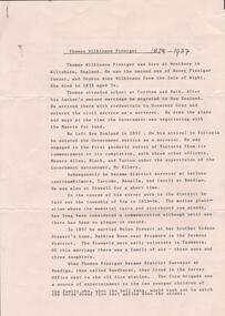
Document - RESEARCH PAPERS: THOMAS WILKINSON PINNIGER, 1828
Thomas Pinniger (1828-1927) was born in England and emigrated to New Zealand before coming to Australia in 1852. With a team of 4 he conducted the first geodetic* survey of Victoria. He became the Government Surveyor for Bendigo in 1853 and in 1854 he laid out the plans for the town of Broadford. His son George, became the Victorian Surveyor General 1925-6. * Large scale mapping based on global measurements of large land masses. It allows corrections for the curvature of the earth.Document detailing the history of district serveyor Thomas Wilkinson Pinniger and his family history. -
 Kew Historical Society Inc
Plan - Subdivision Plan, Jas R Mathers Son & McMillan, Eastlawn Estate : East Kew Auction Sale, 1914
The Kew Historical Society's map collection includes a substantial number of real estate subdivision plans, mainly of Kew but also of surrounding suburbs in Melbourne. Most of the subdivision plans date from the 1920s and 1930s when the districts old homes and local farmland were being split up to accommodate residential growth in the postwar period. These early plans were assembled by a local firm, Jas R Mather & McMillan, which had an office in Cotham Road. Many of the plans, and sometimes photos, were annotated by the agents.Subdivision plans are historically important documents used as evidence for the growth of suburbs in Australia. They frequently provide information about when the land was sold as well as evidence relating to surveyors and real estate and financial agents. The numerous subdivision plans in the Kew Historical Society's collection represent working documents, ranging from the initial sketches made in planning a subdivision to printed plans on which auctioneers or agents listed the prices for which individual lots were sold. In a number of cases, the reverse of a subdivision plan in the collection includes a photograph of a house that was also for sale by the agent. These photographs provide significant heritage information relating house design and decoration, fencing and household gardens.The photograph may also be aesthetically significant depending on the importance of the photographic atelier.The ‘Eastlawn Estate’ was surveyed and ready for auction in March 1914, three months before the outbreak of World War I. Sixty-six allotments, created on the ‘order of Mr & Miss Preston’ surrounded the mansion of Woodlands in Harp Road. Woodlands formed part of the Estate, being advertised as lot 1. The allotments faced High, Station and Wright Streets, Harp and Normanby Roads, and Woodlands Avenue. Pru Sanderson in the Kew Conservation Study (Vol.2, 1988) wrote that the Eastlawn Estate ‘covered the western half of the failed Harp of Erin Estate’. Contemporary advertisements promoted the Eastlawn Estate as: ‘There will be no more convenient district nor pleasant Suburb than East Kew for the busy business man. When the Electric Tram is laid, he will be able to journey quickly and pleasantly direct from Collins Street to his home in the Eastlawn Estate in about 20 minutes’. The actual plans of subdivision were included in advertisements in The Argus and in the local newspapers."C" top left. Various annotations.subdivision plans - kew, station street, normanby road, high street, woodlands avenue, harp road, woodlands - kew -
Kew Historical Society Inc
Archive (series) - Subject File, Victoria Park : Concept Management Plan, Research Papers, 2004, 2004
Graeme Butler & AssociatesProject FilesProvenance OrderRed cardboard wallet containing historical research by Graeme Butler, heritage architect, into the history of Victoria Park, Kew. The file also includes a draft Victoria Park Concept Master Plan, 2004. The research includes memoranda, maps, photocopies of plans, forms, notes, aerial photos, and sundry references.graeme butler - heritage architect, victoria park - kew (vic), heritage studies - kew (vic.)graeme butler - heritage architect, victoria park - kew (vic), heritage studies - kew (vic.) -
 Kew Historical Society Inc
Book, Plan of General Development, Melbourne : Report of the Metropolitan Town Planning Commission
The 1929 report of the Metropolitan Town Planning Commission covering Melbourne and its suburbs. Includes photographs and 15 folding maps (some in rear pocket) This was a planning scheme to prevent 'misuse' of land and protect property values. It highlighted traffic congestion, the distribution of recreational open space and haphazard intermingling of land uses. The plan identified a number of problems, such as the congestion at St Kilda Junction, that were not addressed until decades later. The plan also recognised the value of Melbourne's waterways as an open space network.xii, 308 p., [25] leaves of plates (24 folded) : ill., maps (some col.), ports., plans ; 34 cm. CONTENTS Part 1 Surveys and studies Part II Communications Part III The execution of improvement schemes - a programme of urgent works Part IV Zoning Part V Public Recreation Part VI Public Utilities Part VII Housing and Land Subdivision Part VIII Civic Art and Amenities Part IX Miscellaneous Part X Legislation Part XI Conclusionnon-fictionThe 1929 report of the Metropolitan Town Planning Commission covering Melbourne and its suburbs. Includes photographs and 15 folding maps (some in rear pocket) This was a planning scheme to prevent 'misuse' of land and protect property values. It highlighted traffic congestion, the distribution of recreational open space and haphazard intermingling of land uses. The plan identified a number of problems, such as the congestion at St Kilda Junction, that were not addressed until decades later. The plan also recognised the value of Melbourne's waterways as an open space network.city planning -- victoria. -- maps, city planning -- victoria -- melbourne, city planning -- victoria, civic improvement -- victoria -- melbourne, melbourne -- (vic.), cartography -
Kew Historical Society Inc
Journal, Kewriosity : August 1991
... planning for youth [survey] / p5. Kew saves an endangered species ...The greening of Kew [Street Tree Masterplan] / p1. Free mulching of prunings / p1. Looming threat to the character of Kew [Victorian Government plans for medium-density housing] / p1. Diary dates for August / p2. Free self-defence and relaxation classes / p2. Anonymous house [house numbering requirements] / p2. Tom's incredible Spider Ring! ['The Spider Ring' by Track Players] / p2. Commentary / Cr Daryl Oldaker p3. Chief Executive's Column [Property valuations] / p3. Looking down rat holes [storm water drain audit] / p4. Waste plans not half baked [120 Litre Mobile Bin Recycling Trial] / p4. Lower your gas and electricity bills [Kew Community House workshops] / p4. Tribute to John Fleet Maughan 1898-1991 [City Engineer 1924-63] / p4. Indoor celebration of parkland [opening of Burke Road to High Street section of Outer Circle Linear Park] / p5. Forward planning for youth [survey] / p5. Kew saves an endangered species [Studley Park Red Gum - E.Studleyensis] / p5. Compliments, criticism and complaints [Kew Library Comments Book] / p6. Life in East Kew / Mr Tony de Clifford p6. New face [Pierrette Boustany, Outside School Hours Co-ordinator] / p6. New face [Lisa Gaffney, Public Relations Officer] / p6. Kewriosity deadlines / p6. Advertising [charges] / p6. Thankyou to the volunteers of Kew / p7. Another Anniversaire [Count Francoise de la Perouse] / p7. Heartfelt thanks [donation by East Kew Synagogue congregation to Kew Citizens' Advice Bureau] / p7. Kew Rotary Club good works / p7. Cinema to expand [Balwyn Cinema] / p7. Winter Song [Brian Hansford performs 'Winterreise at St John's Hall, Camberwell] / p8. Come to Cameron Country [Donald Cameron et al at Kew Gallery] / p8. You be the Gypsy [Victor Herbert's 'Gipsy Lady' by Viola Musical Comedy Society] / p8. Classical music in Kew [Kew Philharmonic Society] / p8.Kewriosity was a local newsletter combining Kew Council and community news. It was published between November 1983 and June 1994, replacing an earlier Kewriosity [broad] Sheet (1979-84). In producing Kewriosity, Council aimed to provide a range of interesting and informative articles covering its deliberations and decision making, together with items of general interest and importance to the Kew community and information not generally available through daily media outlets.non-fictionThe greening of Kew [Street Tree Masterplan] / p1. Free mulching of prunings / p1. Looming threat to the character of Kew [Victorian Government plans for medium-density housing] / p1. Diary dates for August / p2. Free self-defence and relaxation classes / p2. Anonymous house [house numbering requirements] / p2. Tom's incredible Spider Ring! ['The Spider Ring' by Track Players] / p2. Commentary / Cr Daryl Oldaker p3. Chief Executive's Column [Property valuations] / p3. Looking down rat holes [storm water drain audit] / p4. Waste plans not half baked [120 Litre Mobile Bin Recycling Trial] / p4. Lower your gas and electricity bills [Kew Community House workshops] / p4. Tribute to John Fleet Maughan 1898-1991 [City Engineer 1924-63] / p4. Indoor celebration of parkland [opening of Burke Road to High Street section of Outer Circle Linear Park] / p5. Forward planning for youth [survey] / p5. Kew saves an endangered species [Studley Park Red Gum - E.Studleyensis] / p5. Compliments, criticism and complaints [Kew Library Comments Book] / p6. Life in East Kew / Mr Tony de Clifford p6. New face [Pierrette Boustany, Outside School Hours Co-ordinator] / p6. New face [Lisa Gaffney, Public Relations Officer] / p6. Kewriosity deadlines / p6. Advertising [charges] / p6. Thankyou to the volunteers of Kew / p7. Another Anniversaire [Count Francoise de la Perouse] / p7. Heartfelt thanks [donation by East Kew Synagogue congregation to Kew Citizens' Advice Bureau] / p7. Kew Rotary Club good works / p7. Cinema to expand [Balwyn Cinema] / p7. Winter Song [Brian Hansford performs 'Winterreise at St John's Hall, Camberwell] / p8. Come to Cameron Country [Donald Cameron et al at Kew Gallery] / p8. You be the Gypsy [Victor Herbert's 'Gipsy Lady' by Viola Musical Comedy Society] / p8. Classical music in Kew [Kew Philharmonic Society] / p8. publications -- city of kew (vic.), kewriosity, council newsletters, community newsletters -
Kew Historical Society Inc
Journal, Kewriosity : April 1991
Still delivering the goods [Kew Post Office] / p1. Grand Parade [photos Kew Festival] / p1. Dates for April / p2. Heritage Advisor [Heritage Advisory Service] / p2. Council Voter's Roll / p2. Nobody does it better [The Fabulous Nobody Theatre Company present 'Joseph and His Amazing Technicolour Dream Coat'] / p2. Commentary [Commercial Area Strategy Plan] / Cr Daryl Oldaker p3. Traffic School appointment [Marion Burg] / p3. Recycling trial [120 litre mobile recycle bins] / p4. Enlarging [large print] book collection [Kew Library] / p4. Bin gardening lately [composting] / p4. Alex Jessup [death] / p4. Roads desire [road reconstruction and maintenance] / p5. No alcohol at this AGM [People Against Drink Driving (PADD)] p5. Recreation Centre investment [works] / p5. Breathe easily / p5. RSL milestone [75th anniversary] / p5. New look City Hall [re-carpeting] / p5. Kewrious to know [Council surveys] / p5. Senior Citizens' Week / p5. Senior Citizens' good deed [accessible toilets at Senior Citizens' Centre] / p5. [Level] Crossing supervisor / p5. Wizz, chief cook, and ... [Joe Wormald, 1991 Citizen of the Year] / p6. Historic buildings [12 Uvadale Grove] / p6. Spiritual offerings [Rotary Club of Kew Art Competition] / p6. History of Kew Library / p6. Cab & Co [Citizens Advice Bureau] / p6. Music in [the] Round returns [Chamber music festival] / p7. Inspect Strathcona / p7. Date of Census / p7. Brasses and basses wanted [Kew Philharmonic Society] / p7. Kinder turning 40 [J.J. McMahon Memorial Kindergarten] / p7. Plate replacement [Neighbourhood Watch plates] / p7. The Devil's Advocate [unrateable properties] / Allan Hutchinson J.P. p8. Do festivals divert attention? / p8.Kewriosity was a local newsletter combining Kew Council and community news. It was published between November 1983 and June 1994, replacing an earlier Kewriosity [broad] Sheet (1979-84). In producing Kewriosity, Council aimed to provide a range of interesting and informative articles covering its deliberations and decision making, together with items of general interest and importance to the Kew community and information not generally available through daily media outlets.non-fictionStill delivering the goods [Kew Post Office] / p1. Grand Parade [photos Kew Festival] / p1. Dates for April / p2. Heritage Advisor [Heritage Advisory Service] / p2. Council Voter's Roll / p2. Nobody does it better [The Fabulous Nobody Theatre Company present 'Joseph and His Amazing Technicolour Dream Coat'] / p2. Commentary [Commercial Area Strategy Plan] / Cr Daryl Oldaker p3. Traffic School appointment [Marion Burg] / p3. Recycling trial [120 litre mobile recycle bins] / p4. Enlarging [large print] book collection [Kew Library] / p4. Bin gardening lately [composting] / p4. Alex Jessup [death] / p4. Roads desire [road reconstruction and maintenance] / p5. No alcohol at this AGM [People Against Drink Driving (PADD)] p5. Recreation Centre investment [works] / p5. Breathe easily / p5. RSL milestone [75th anniversary] / p5. New look City Hall [re-carpeting] / p5. Kewrious to know [Council surveys] / p5. Senior Citizens' Week / p5. Senior Citizens' good deed [accessible toilets at Senior Citizens' Centre] / p5. [Level] Crossing supervisor / p5. Wizz, chief cook, and ... [Joe Wormald, 1991 Citizen of the Year] / p6. Historic buildings [12 Uvadale Grove] / p6. Spiritual offerings [Rotary Club of Kew Art Competition] / p6. History of Kew Library / p6. Cab & Co [Citizens Advice Bureau] / p6. Music in [the] Round returns [Chamber music festival] / p7. Inspect Strathcona / p7. Date of Census / p7. Brasses and basses wanted [Kew Philharmonic Society] / p7. Kinder turning 40 [J.J. McMahon Memorial Kindergarten] / p7. Plate replacement [Neighbourhood Watch plates] / p7. The Devil's Advocate [unrateable properties] / Allan Hutchinson J.P. p8. Do festivals divert attention? / p8. publications -- city of kew (vic.), kewriosity, council newsletters, community newsletters -
 Kew Historical Society Inc
Plan - Subdivision Plan, Eastlawn Estate, 1914
Subdivision plans are historically important documents used as evidence of the growth of suburbs in Australia. They frequently provide information about when the land was sold on which a built structure was subsequently constructed as well as evidence relating to surveyors and real estate and financial agents. The numerous subdivision plans in the Kew Historical Society's collection represent working documents, ranging from the initial sketches made in planning a subdivision to printed plans on which auctioneers or agents listed the prices for which individual lots were sold. In a number of cases, the reverse of a subdivision plan in the collection includes a photograph of a house that was also for sale by the agent. These photographs provide significant heritage information relating house design and decoration, fencing and household gardens.The ‘Eastlawn Estate’ was surveyed and ready for auction in March 1914, three months before the outbreak of World War I. Sixty-six allotments, created on the ‘order of Mr & Miss Preston’ surrounded the mansion of Woodlands in Harp Road. Woodlands formed part of the Estate, being advertised as lot 1. The allotments faced High, Station and Wright Streets, Harp and Normanby Roads, and Woodlands Avenue. Pru Sanderson in the Kew Conservation Study (Vol.2, 1988) wrote that the Eastlawn Estate ‘covered the western half of the failed Harp of Erin Estate’. Contemporary advertisements promoted the Eastlawn Estate as: ‘There will be no more convenient district nor pleasant Suburb than East Kew for the busy business man. When the Electric Tram is laid, he will be able to journey quickly and pleasantly direct from Collins Street to his home in the Eastlawn Estate in about 20 minutes’. The actual plans of subdivision were included in advertisements in The Argus and in the local newspapers.subdivision plans - east kew, eastlawn estate -
 Kew Historical Society Inc
Plan - Subdivision Plan, 10 Fine Villa Sites: Ermington Estate, Kew Heights, ca. 1917
Pru Sanderson, in her groundbreaking ‘City of Kew Urban Conservation Study : Volume 2 - Development History’ (1988), summarised the periods of urban development and subdivisions of land in Kew. The periods that she identified included 1845-1880, 1880-1893, 1893-1921, 1921-1933, 1933-1943, and Post-War Development. These periods were selected as they represented periods of rapid growth or decline in urban development. An obvious starting point for Sanderson’s groupings involved population growth and the associated economic cycles. These cycles also highlighted urban expansion onto land that was predominantly rural, although in other cases it represented the decline and breakup of large estates. A number of the plans in the Kew Historical Society’s collection can also be found in other collections, such as those of the State Library of Victoria and the Boroondara Library Service. A number are however unique to the collection.The Kew Historical Society collection includes almost 100 subdivision plans pertaining to suburbs of the City of Melbourne. Most of these are of Kew, Kew East or Studley Park, although a smaller number are plans of Camberwell, Deepdene, Balwyn and Hawthorn. It is believed that the majority of the plans were gifted to the Society by persons connected with the real estate firm - J. R. Mathers and McMillan, 136 Cotham Road, Kew. The Plans in the collection are rarely in pristine form, being working plans on which the agent would write notes and record lots sold and the prices of these. The subdivision plans are historically significant examples of the growth of urban Melbourne from the beginning of the 20th Century up until the 1980s. A number of the plans are double-sided and often include a photograph on the reverse. A number of the latter are by noted photographers such as J.E. Barnes.In November 1917, the Ermington Estate was advertised as an ‘Executor’s Sale’. It included the 10-roomed villa residence, ‘Ermington’, home of the late Mrs. Lorimer, and 10 ‘magnificent allotments’. The plan in the Kew Historical Society Collection is a little more specific. Ermington is described as having 9 Rooms &c. and there are 11 lots shown on the west side of Hillcrest Avenue. In the plan, the latter is named as ‘Hill Crest Avenue’. The plan indicates that the subdivision was based on the surveying work of Johnson & Tait. Opposite Ermington, the existing house ‘Parkhill’ is identified. A faded stamp on two parts of the plan indicates that it was in the possession of Jas. [R.] Mathers, Financial Agent, [136] Cotham Road, Kew.subdivision plans - kew, ermington heights estate - kew heights -
 Kew Historical Society Inc
Plan - Subdivision Plan, Jas R Mathers Son & McMillan, Clifton Estate, Kew, c. 1916
Pru Sanderson, in her groundbreaking ‘City of Kew Urban Conservation Study : Volume 2 - Development History’ (1988), summarised the periods of urban development and subdivisions of land in Kew. The periods that she identified included 1845-1880, 1880-1893, 1893-1921, 1921-1933, 1933-1943, and Post-War Development. These periods were selected as they represented periods of rapid growth or decline in urban development. An obvious starting point for Sanderson’s groupings involved population growth and the associated economic cycles. These cycles also highlighted urban expansion onto land that was predominantly rural, although in other cases it represented the decline and breakup of large estates. A number of the plans in the Kew Historical Society’s collection can also be found in other collections, such as those of the State Library of Victoria and the Boroondara Library Service. A number are however unique to the collection.The Kew Historical Society collection includes almost 100 subdivision plans pertaining to suburbs of the City of Melbourne. Most of these are of Kew, Kew East or Studley Park, although a smaller number are plans of Camberwell, Deepdene, Balwyn and Hawthorn. It is believed that the majority of the plans were gifted to the Society by persons connected with the real estate firm - J. R. Mathers and McMillan, 136 Cotham Road, Kew. The Plans in the collection are rarely in pristine form, being working plans on which the agent would write notes and record lots sold and the prices of these. The subdivision plans are historically significant examples of the growth of urban Melbourne from the beginning of the 20th Century up until the 1980s. A number of the plans are double-sided and often include a photograph on the reverse. A number of the latter are by noted photographers such as J.E. Barnes.The Clifton Estate was an ambitious subdivision. It included 61 allotments bordering Cotham and Park Hill Roads, and Florence and Adeney Avenues. It is difficult to ascertain the exact year when the ‘Clifton Estate’ was surveyed, subdivided and first auctioned. The uncertainty may be due to allotments being released during the First World War. The subdivision took its name from the house ‘Clifton’ (lot 5) on the corner of Adeney Avenue and Cotham Road. The outline of Clifton (since demolished) and the extent of its land following the subdivision are represented on the plan. The auctioneers have also shown ‘Maryfield’ and ‘Wimba’, the neighbouring properties in Cotham Road, on the plan."B"subdivision plans - kew, clifton estate, cotham road, adeney avenue, florence avenue, park hill road -
Stawell Historical Society Inc
Instrument - Realia, Engineering Instruments from Northern Grampians Shire
1: Small cardboard box with lid containing Silver distance Measurer. This was used for Measuring distances on plans.(Planimeter) 2: Cardboard Box without lid containing three plumbobs: One large turned brass: one small turned metal. One circular silver coloured metal complete with string and winding board. These were used to locate survey equipment above a fixed point. 3: Timber ( Vic Ash?) dovetailed box with brass hinged lid and brass swing catches containing plywood templates called railway curves, used for drawing curves on plans. 4: Cardboard box with lid containing Allbrit panimeter in Bakelite/plastic box with silver metal hinges and catches "Shire of Kara Kara" inscribed on the box. The box contains the original Instructions. The Planimeter was used for calculating areas of Irregular shapes and used for estimating quantities from plans of cut and fill projects, as one example. 5: Timber Box with brass hinges and swing catches wand leather carry Strap containing one set of self adjusting level made by E.R. Watts and Son, London England. Paper label on the inside "Shire of Stawell". Also had paper instructions pasted to the inner lid. The level was used for taking Ground Levels. The first 3 have been in use up until the 1990's, when computer drafting took over the role of these instruments with greater speed and accuracy. The dumpy level would have been superseded in the 1980's when automatic levels became cheaper, and were more accurate. stawell -
 Surrey Hills Historical Society Collection
Book, Medlow Garden Survey and Landscape capability study 1983, Oct-83
... , rehabilitation and plans. land surveys medlow garden bismark estate ...Includes: Plan of Subdivision, Detailed plan, map of garden, Auctioneer's plan for 1854 sale, Botanical plan of Medlow & Landscape history notes. Full title : Medlow Garden survey and landscape capability survey. A report for the National Trust of Australia (Victoria) A report giving a detailed landscape survey of Medlow Garden estate. Includes landscape story, cultural significance, particulars about vegetarian, garden, rehabilitation and plans.Copy of a report giving a detailed landscape survey of Medlow Garden estate. Includes landscape story, cultural significance, particulars about vegetarian, garden, rehabilitation and plans. 38 pages with illustrations.land surveys, medlow garden, bismark estate, rosalie estate, warrigal road, surrey hills, bismarck avenue, warwick avenue, t p payne, (mr) hugh glass, boroondara, (mr) (maj) - cairncross, (mrs) mary jane cairncross, (dr) (mr) richard joseph bull, (mrs) catherine grace bull, (miss) norma bull, (mr) ronald richard bull, medlow -
 Surrey Hills Historical Society Collection
Book, Medlow Garden Survey and Landscape capability study 1983, Oct-83
... , rehabilitation and plans. land surveys medlow garden bismark estate ...Includes: Plan of Subdivision, Detailed plan, map of garden, Auctioneer's plan for 1854 sale, Botanical plan of Medlow & Landscape history notes. Full title : Medlow Garden survey and landscape capability survey. A report for the National Trust of Australia (Victoria) A report detailing the landscape survey of Medlow Garden estate. Includes landscape history, cultural significance, particulars about vegetarian, garden, rehabilitation and plans.A report detailing the landscape survey of Medlow Garden estate. Includes landscape history, cultural significance, particulars about vegetarian, garden, rehabilitation and plans. 38 p illland surveys, medlow garden, bismark estate, rosalie estate, warrigal road, surrey hills, bismarck avenue, warwick avenue, t p payne, (mr) hugh glass, boroondara, (maj.) (mr) - cairncross, (mrs) mary jane cairncross, (dr)(mr) richard joseph bull, (mrs) catherine grace bull, (miss) norma bull, (mr) ronald richard bull, medlow, house names, (mr) rex swanson, landform australia