Showing 1059 items matching "boundaries"
-
 Melbourne Tram Museum
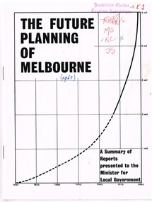
Document - Report, Commerce News, "The Future Planning of Melbourne - A summary of Reports - Minister for Local Government", 1967
Printed report or paper, 16 pages on gloss paper, centre stapled titled "The Future Planning of Melbourne - A summary of Reports presented to the Minister for Local Government" looking at the growth of Melbourne, water supply, metropolitan boundaries, 1966-67. Includes submissions from Town and Country Planning Association, MMBW, Regional planning, decentralisation, finance, commuter services. Process created by Rupert Hamer, the Local Government Minister at the time. Published as a supplement to "January Commerce News.""4E1" in ink on front cover, AETA stamp, the date "(1967)" and peoples initials on the front cover.trams, tramways, melbourne, victoria, development -
 Federation University Historical Collection
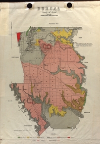
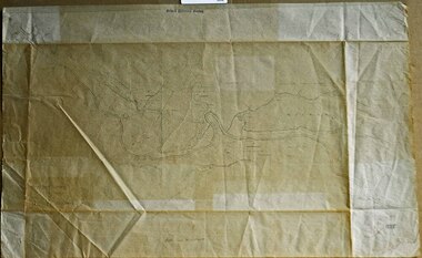
Map - Plan, E.J. Dunn, Bungal County of Grant Parish Plan
... State Regional Boundaries Committee ...E.J. Dunn was the surveyor of this parish plan.Colour geological plan of Bungal in the County of Grant, Victoria. The areas circled in red ar craters.plan, bungal, bungeltap, black horse co. egerton, egerton, mount egerton, sister rose shaft, south learmonth co, kerrit bareet, bungaeeltap, yaloak, eastern moorabool river, corong, bungal station preemptive right, lal lal, western moorabool river, moorabool rover, borhoneychurck, mount egerton battery, bungal creek -
 Federation University Historical Collection
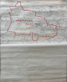
Map, Ballarat Municipalities and City Boundary
Piece of linen attached at top and bottom with wooden rails. Top half of linen has a paper map of Ballaarat Province and Surrounding Municipalities directly attached to it and reads 'Ballaarat Province' in red ink which outlines the greater Ballarat area with surrounding municipalities shown in blue. Scale is '8 miles to 1 inch'. Bottom half is drawn directly onto linen and depicts Ballaarat City Boundary including street names. 'Scale about 20 chains to 1 inch'.ballarat electorate, map, ballaarat province, ballarat to buninyong railway -
 Ringwood and District Historical Society
Document - Copy of Lands Department Field Notes - Parish of Ringwood, Victoria, Field Notes - OP34838 - surveyed in 1919 by D. Barker
5615b Foolscap size photocopy of survey map with handwritten notations. References include Braeside Avenue, Mount Dandenong Road, Rosedale Court, Railway Avenue, cyclone fence, Sec A, WB house, old tennis court netted, stable, old shed, tank stand, orchard, Township Boundary, netting fence, Railway fence, Ringwood to Lilydale Railway, I certify that these fieldnotes are a true copy of the actual results of observations & measurements taken by me on the ground (signed) D. Barker (1919). -
 Nillumbik Shire Council
Public Art: Helen BODYCOMB (b.1964, South Australia) and Enver CAMDAL (Lives and works Turkey), Enver Camdal et al, Nest (Location: Roundabout, Main and Luck Street, Eltham), 1997
Commissioned by Nillumbik Shire Council - 1997 The selection panel in the commissioning process to this 'extraordinary acquisition' was Rhonda Noble, Director of La Trobe University Museum of Art, Jeph Neale, Eltham Roundabout Advisory Group, Chris Marks, NSC Curator of Collections, Geoff Glynn, NSC Manager of Infrastructure Development.'Nest' highlights the indigenous flora and fauna of the Shire. The stiff, coarse grass used to create the nest is indigenous to the area and the eggs are like those of the spotted quail thrush, a ground-nesting bird of the Shire. The circular flow or placement of the eggs recalls the revolution of the seasons and nesting cycles. There is a tall light pole above the eggs, shining down at night. The effect is of a giant incubator. Enrichment and nurturing of the larger environment can be associated with this sculpture. This work resembles a large bird's nest, with three egg-like forms of fibreglass covered in a pebble render, set on sand. The nest is positioned within the paved boundary of the roundabout. The nest shape has been created out of stiff, coarse indigenous grass, periodically trimmed so the view is not obstructed. The eggs are a brown-speckled, creamy yellow colour. The three eggs are arranged in a ring, with the narrow end of each pointing to the large end of the next, in a circle that mimics the flow of traffic. N/Apublic art, nest, eggs, eltham, ekphrasis2017, mosaic, pebbles, roundabout, spotted quail thrush -
 Melbourne Tram Museum
Document - Report, Melbourne & Metropolitan Tramways Board (MMTB), "Municipal Miles, late 1920's to mid 1930's
File- card, green grey - Rondo of London type, titled "Municipal Miles" - giving the calculations and background paperwork for the breakdown of the tramway system by municipality. Used late 1920's to mid 1930's. The top sheet, scanned, though superseded shows the route miles by double track, single track, shared at council boundaries and the total miles of track. See Reg Item 2083 for tram miles for the system as a whole - was this information required for rate valuation returns.trams, tramways, mmtb, trackwork, mileages, reports, councils -
 Kiewa Valley Historical Society
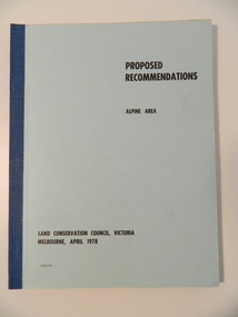
Report - Alpine Area Proposed Recommendations, Land Conservation Council, Victoria Melbourne, April 1978, April 1978
The Land Conservation Council was established by the Land Conservation Act 1970. It makes recommendations to the Minister for Conservation with respect to the use of public land. Notices showing the boundary of the study area ... published in the Victorian Government Gazette Sept. 1973. A descriptive report was published in July 1977. Submissions (1538) on the future use of public land were received & included those representing a wide cross-section of the community. These were considered in the final report.Of interest for research on the changing ideas regarding the use of public land and the environment.Blue book bound by dark blue cloth tape. It has 92 pages with maps at the end and an empty folder inside the back cover.alpine area, land conservation council, alpine study area report -
 Eltham District Historical Society Inc
Negative - Photograph, J.A. McDonald, Eltham-Yarra Glen Road, Lower Plenty footbridge, Sep. 1955
Tony Carberry and J. Jolly The Eltham-Yarra Glen Road as designated originated at the Shire of Eltham boundary at the Plenty River. West of the river the road was known as the Heidelberg-Eltham Road. The section from the Plenty River is now known as Lower Plenty Road which becomes Main Road. The footbridge no longer exists but was originally sited to the south, adjacent to the old Lower Plenty Bridge, now part of the Plenty River Trail. Record of various Shire of Eltham infrastructure works undertaken during the period of 1952-1962 involving bridge and road reconstruction projects, sometimes with Eltham Shire Council Project Reference numbers quoted. It was during this period that a number of significant improvements were made to roads and new bridges constructed within the shire that remain in place as of present day (2022). In many situations, the photos provide a tangible visible record of infrastructure that existed throughout the early days of the Shire. The album was put together by or under the direction of the Shire Engineer, J.A. McDonald.1955-09, eltham-yarra glen road, lower plenty footbridge, j. jolly, lower plenty, lower plenty bridge, lower plenty road, main road, plenty river trail, tony carberry, bridge construction, infrastructure, shire of eltham -
 Kiewa Valley Historical Society
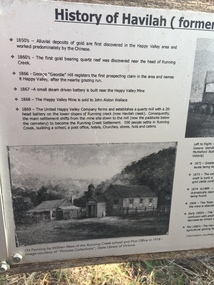
Papers - Havilah Cemetery, Havilah Cemetery Formerly Running Creek Cemetery
In 1889, 24 residents of the Running Creek and surrounding district submitted a petition to the Minister of Lands, Melbourne requesting land for a cemetery. Their request was granted. The Cemetery was decommissioned in the early 1950s and the last trustee for the cemetery died in 1986. There is a wooden fence around the boundary (May 2024). One paper lists 29 names in the Burial Register 1861-1948. The last two sheets record the history as a timeline from the 1850s to the 1900s. Havilah was a gold mining settlement from the 1850s located 20km west of the Kiewa Valley and in the Ovens catchment near Myrtleford.Five black and white A4 pages stapled together. Copies of the sign erected at the gate of 'Havilah cemetery formerly Running Creek Cemetery'. Also the 'History of Havilah formerly Running Creek'havilah, running creek, cemetery -
 Melbourne Athenaeum Archives
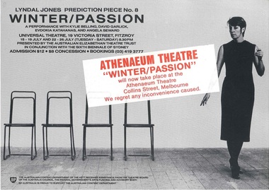
Flyer, Poster & newspaper article, Prediction Piece 8: Winter/Passion Lyndal Jones performed at the Athenaeum 2 commencing 15th July 1986
Transferred from original performance location in Fitzroy to Melbourne Athenaeum Theatre. The Elizabethan Trust production was performed after a season at the Sydney Biennale. The performance consisted of five, 20-minute variations on a fictional love story. The theatre review by Leonard Radic comments: This kind of performance theatre is an attempt to cross the boundaries between art and theatre. It is genuinely experimental in that it seeks to give new meaning to old situations. ... It dares to be different.Large flyer, 2 small flyers and newspaper articleprediction piece 8: winter/passion, lyndal jones, athenaeum theatre, the australian elizabethan trust, program -
 Ballarat Heritage Services
Photograph - Colour, Clare Gervasoni, Fawcett Hall and Public Library, 2015, 11/01//2015
Fawcett Hall is 14 kilometres North West of Alexandra, North East Victoria, in Spring Creek Road and is set amongst a small picturesque rural farming and business community with hills as a backdrop and Stony Creek running alongside the public reserves property boundary. Part of our hall building dates back to its establishment in 1882. Originally the hall served as a Mechanics Institute and Public Library and later as a primary school.Colour photograph of a weatherboard Hall.fawcett hall and public library, fawcett, fawcett mechanics' institute -
 Department of Energy, Environment and Climate Action
Planimeter (roller digital)
The rollers move over the map as the tracing arm is used to follow the boundary to be measured. The wheels allow unlimited horizontal travel and vertical travel within the limits of the arm movement. They measure in the X and Y directions Reading from the digital scale the area in square centimetres could be measured. Knowing the scale of the mapsheet the figure was converted to areas or hectares Generally at least three measurements were taken to ensure accuracy and precisionPlanimeter used to measure areas from scale maps. Includes box but no charger Plancom KP90forests commission victoria (fcv), forest measurement, surveying -
 Bendigo Historical Society Inc.
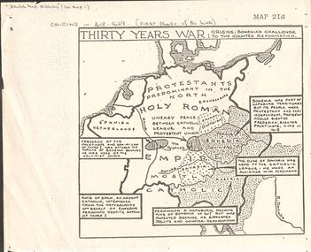
Document - GERMAN HERITAGE SOCIETY COLLECTION: MAPS OF GERMANY (PERIODS OF CHANGE)
Item 21. Maps of Germany (Periods of Change) held in two buff coloured commerce folders. Name written on the front in purple. Three loose copies of the Thirty Years War Map 21a, 21c and 21d. Maps of the Thirty Years War,Europe at the End of the 15th Century, The Reformation in Europe (16th Century), /Europe in the Time of Charles II & James II, The Domination of France 1660 - 85, Europe in the Time of Henry VIII, Germany in 1807 after reconstruction by Napoleon, German Federation 1815, The German Federation 1815, The German Empire of 1871, The Growth of the German Zollverein, Boundaries Before 1918 showing Kingdoms, Duchies, Provinces, etc., of the Former German Empire, the German Empire (1871 - 1918), and Boundaries before 1918 showing Kingdoms, Duchies, Provinces, etc., of the Former German Empire. The last page has a small map of Europe, a small map showing East and West Berlin, German Coats of Arms, Comparative International Figures of Population and a short article titled 'Do You Know Germany'.document, certificate, maps of germany, german heritage society collection - maps of germany (periods of change) -
 Eltham District Historical Society Inc
Photograph - Colour Print, Belle Vue, Livingstone Road, Eltham, c.2015
Belle Vue property in Livingstone Road, Eltham was once owned by Society member Jo McCormick. Jo was a valued member of our committee and dear friend of many of our members until her death in 2009. Belle Vue is the farmhouse of a property that is now a significant part of suburban Eltham, just a short distance north of the town centre. Originally purchased by pioneer Eltham farmer Henry Stooke, the present-day old farmhouse sits within an extensive suburban residential area. The history of the property is largely based on a heritage assessment prepared by consultant Lorraine Huddle for Nillumbik Shire Council. Additional information from our Society records reveals Belle Vue farm comprised about 56 ha (140 acres) extending northerly from the northern boundary of Holloway’s 1851 Little Eltham subdivision. On the present day map the southern boundary was just north of Elsa Court and Grove Street. The western boundary was the Diamond Creek and extended northerly to Main Road where it turns easterly towards Research. It was traversed by the main road to Kangaroo Ground and beyond and from 1912 by the railway to Hurstbridge. From 1895 the farm was owned by William Williams and his wife Mary Ann. In 1914 -15 they built a new house now known as Belle Vue. They sold the land in 1920 and residential subdivision began soon after that. Belle Vue remains today on a substantially subdivided and very much reduced size residential lot in Livingstone Road. The house and many old trees on the site were subject to a heritage overlay under the Nillumbik Planning Scheme. Despite that overlay, the development and subdivision of the original land resulted in most of the heritage listed trees being removed. belle vue, eltham, livingstone road -
 Warrnambool and District Historical Society Inc.
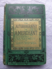
Book, The Autography of a Merchant, late 19th century
This book was given in 1886 as a prize to Annie Egerton from Allansford State School. The prize was for recitation. Allansford State School No. 3 was opened in 1856 as a National School and is still operating. Allansford is about ten kilometres from the Warrnambool city area and most of it today is within the boundaries of the City of Warrnambool. John Jones was the Head Master of the school from 1867 to 1891. No details have been found on Annie Egerton or her family This book is of interest because it concerns 19th century Allansford State School, Head Master John Jones and pupil Annie Egerton. It is also a book of antiquarian interest. This is a hard cover book of 436 pages. It has a green cover with gold and black ornamentation and black and green lettering. The pages are edged with gold colouring. The book has 36 chapters telling the story of the merchant, James Meetwell and some pages at the back giving details of other books available from the publishers, Ward, Lock & Co. The cover is somewhat soiled. There is an inscription inside the front cover with handwriting in black ink and the word ‘Reciting’ written in pencil on the second page. ‘Allansford S. School, 3, Presented to A. Egerton for Reciting, 19-4-86, J.E.Jones, teacher’ ‘Reciting’ annie egerton, allansford primary school, john jones,, allansford state school, history of allansford -
 Federation University Historical Collection
Scientific Instument, Anemometer, 6 Cup Model: Serial No. AM1-6-8875, c1975-1980
An anemometer is intended for determining velocity distribution over an area or in a boundary layer. This item was purchased by Mechanical Engineering upon the request of Dr Len Cubitt, to determine wind speed at various heights above the ground. Investigation related to wind energy harnessing projects, including that undertaken by MARS Industries in Ballarat. The 6-cup anemometer had a marked superiority in tests over the 3-cup anemometer and also had lower starting speeds.Anemometer in a case complete with mounting blocks, but without electric leads for connecting the black finished wood case which also incorporates pulse counters and connections for power supply and for other logging instruments. Serial Number AM1-6-8875 Name Plate on lid between clasps. 'RIMCO" RAUCHFUSS INST & STAFF Pty Ltd 12 Monomeath Drive, Mitcham, Vic. 3132" scientific instrument, anemometer, len cubitt, mechanical engineering, energy harnessing projects, starting speeds -
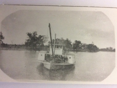 Port of Echuca
Black and white photograph, 1907
The P.S Canally was built in 1907 by R.W. Beer. Known as the "Greyhound of the River" after her original engine was substituted with a Railway locomotive, minus the wheels.The speed of the Canally set up tremendous wash, which sank any small craft. In 1929 it was sold to N. Collins who converted it to a barge. The Chislett Brothers were the owners when the P.S Canally sank at Boundary Bend in 1962. (Ref . Parsons R. "Ships of the Inland Rivers." P.58.)The P.S.Canally is significant because it was fitted with a locomotive, minus the wheels. This is significant because it shows the need for the paddle steamers to travel fast. This could show the competitiveness of the paddle steamer trade on the river in the early 20th Century. A small black and white photograph of an old photograph of the P.S Canally in the middle of the river. The paddle steamer is travelling towards the camera. p.s canally, beer, r.w., chislett brothers, collins, n. -
 Whitehorse Historical Society Inc.
Photograph, Cook Family
William Cook was one of the earliest settlers in Vermont. Having returned from the W.A. goldfields he married Jane Maggs in 1880 at Wickliffe, Victoria and his only child, Amy, was born in 1881 at Box Hill. William Cook's property fronted Whitehorse Road, Mitcham and ran north almost to the Mullum Mullum Creek. He shared part of his eastern boundary with the Schwerkolt family. William Cook specialised in cherries and became known as 'The Cherry King'Sepia photograph mounted on card of a woman and a girl standing in front of a wooden house with iron lace on the verandah. A path leads down the side of the house.cook, amy, jane, orchards -
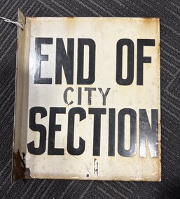 Ballarat Tramway Museum
Sign, "END OF SECTION - C1", 1951?
These signs became necessary after the introduction of CITY SECTION fares in July 1951 to indicate to conductors and passengers the boundary of the city section, where a special fare applied. Used by SEC until 9/1971. Acquired by BTPS Museum in Oct. 1971 from SECV. Used at Dawson & Sturt St. Was physically removed from pole by levering it off, damaging lower part of sign. See item 704 for a plan showing the Ballarat tram sections.Demonstrates a SECV End of Section sign for a particular location.Sheet steel folded for a pole-mounted sign and then enamelled with words (white background, black letters) "END OF SECTION" on both sides. Drilled with two holes for mounting bolts on the small leg. Similar style to that used by the M&MTB. Has had the words "City" and "C1" painted on the sign in black paint, which is in poor condition. Has a right-angled flange with two holes to secure it to a pole.trams, tramways, secv, ballarat, fares, street furniture, end of section sign -
 Bendigo Historical Society Inc.
Document - PETER ELLIS COLLECTION: LETTER, 4th October, 1976
Letter, dated 4/10/1976 from Diana R. Collier, Hon. Secretary, The Bendigo Field Naturalists Club to The Minister for Lands, The Hon. W. A. Borthwick making an application to have a reserved area for the preservation of native flora and fauna near the Quarry Hill Golf Club. Features, fauna and flora are mentioned including an original Boundary Stone and the Fairy Waxflower (Eriostemon verrucosus) also known as the Bendigo Wax Flower. Included is a list of birds (including some that nest in the area sometimes) and plants.communication, postal, letters, peter ellis collection, the bendigo field naturalists club, proposed boyd st nature reserve, the hon w a borthwick, recreation reserve extension (rs 3458), cemetry reserve extension (rs 3777), rubbish depot (rs 5980), education purposes reserve, (rs 6402), j willis, bendigo city council, city boundary stone, regel, quarry hill golf club, canberra botanical gardens, stony ridge flora reserve sydney, kings park perth, maranoa gardens melbourne, kaweka sanctuary castlemaine, central and northern branch of the national trust, school sanctuary (quarry hill), education dept, society for growing australian plants - bendigo group, lawn cemetery, bendigo city council parks and recreation dept, bendigo trust afforestation committee, quality of life action group, ackhurst plan, winifred waddell estate, dept of crown lands and survey, ministry for conservation, mr g edwards, mr m goode, mr j chellacombe, diana r collier -
 Bayside Gallery - Bayside City Council Art & Heritage Collection
Map, Department of Crown Lands and Survey, Melbourne and Suburbs, City of Sandringham, 1917-1926
map, plan, foreshores, sndringham, hampton, beaumaris, cheltenham, department of lands and survey, cartographic material, borough of sandringham, moorabbin, black rock, street map, city of sandringham -
 Bendigo Historical Society Inc.
Document - MARKS COLLECTION: PARISH PLAN OF WHITE HILLS
Sepia coloured map showing allotments in Parish of Sandhurst (White Hills) Written on LH side of map town and Suburban Lots White Hills Parish of Sandhurst. Scale is shown in chains. Surveyed by Horage Walker. Photo lithographed at the Department of Lands & Survey, Melbourne by J.Noone, Price 1/-. 6th. January 1865. Map shows Race Course Reserve at top of sheet, Municipal boundary is marked on LH side. Comments re vegetation throughout map. For example, poor soil timbered with Box scrub.on the back--Plan of Land White Hills Sandhurstbendigo, planning, white hills parish map, horage walker, j noone, department of lands and survey, -
 Warrnambool and District Historical Society Inc.
Documents, Late 20th, early 21st centuries
These ten documents (maps, plans, photographs) mostly come from the Warrnambool City Council and most contain information on sub-divisions and titles of properties in areas around the Central Business District of Warrnambool. The dates range from 1986 to 2006. These maps, plans and photographs are of some interest as they give historical details of subdivisions in Warrnambool and date from the late 20th century. .1 This is a laminated map of the boundaries of Local Governments in Victoria. It is Sheet I of 2 and has red and blue pencil markings and black boundary markings. .2 This is a copy of a plan of a survey in black and white markings on paper. .3 This is a plan of the title details of Section 19 Warrnambool. It has black printing on buff-coloured paper. .4 This is a plan of the allotments in part of the Central Business District of Warrnambool. It is printed in black and white. .5 This is a 2006 coloured aerial photograph of the harbour at Warrnambool – Breakwater etc. .6 This is a 2006 coloured aerial photograph of the Lake Pertobe area in Warrnambool .7 This is a coloured aerial photograph of Warrnambool’s streets over-stamped with road numbers in large blockings. .8 This is a plan showing the title details of Section 11 in Warrnambool. It has black printing on buff-coloured paper. .9.1 This is a plan of sub-divisions in parts of Crown Allotments 38 & 39 in Warrnambool. It has green, pink and yellow markings with black printing. .9.2 This is a plan of the sub-divisions in parts of Allotments 38 & 39 in Warrnambool. It has pink, yellow and blue markings with black printing. It is somewhat faded. warrnambool c.b.d. maps and plans, history of warrnambool -
 Kiewa Valley Historical Society
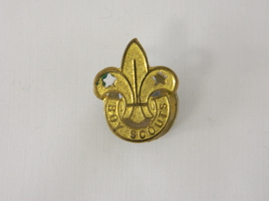
Badge Boy Scout, circa mid to late 1900's
This badge, which was used in the mid to late 1900's (Scouts started in Australia in 1909) clearly demonstrates that the families in the Kiewa Valley although slightly remote were still able to participate in one of the prime "boy" only social groups. The Boy Scouting movement brought together boys from all the socio-economic areas in the Australian population. The scouting group applied the concept of self sufficiency and friendship to all its membership. It was an avenue to cross the boundaries of distance and regional mores. Many of the boys in the Kiewa Valley and its regions would have been more "in tune" with the core principles of the scouting movement because being in a rural environment and "living on the land" was a day to day part of their life. What was an important aspect to they was the "mateship" and the belonging to a very large, and international, group of "like minded" boys. This avenue of interacting with a larger group of boys cut through the "small population" mores of a rural and at times isolated environment. This Boy Scouting activity was both mentally and physically significant to growing boys within the Kiewa Valley as it opened up the world to them.This brass badge has a front formed in a half circle base supporting a "Fleur de Leis" in a spear shape with "cut outs" at the appropriate places to provide the emphasis needed to project the form. Attached to the badge is a crescent moon shaped pronged frame for attaching the badge to lapels or collars or button eyelets. On the bottom scroll "BOY SCOUTS" and on the back type fastener "STOKES & SONS" below this "Melb".societies, boy scouts, apparel badges, numismatics badges -
 Orbost & District Historical Society
survey sheet, circa 1870's
E.L. Bruce, born in Ireland on July 1,1854, came to Australia in 1854 and joined the Lands Department. He spent most of his service in Gippsland. The journey to Sale then was made by ship to Port Albert and thence on horseback. He began his service in Gippsland as assistant district surveyor and for the last 12 years before retirement he was district surveyor and land officer. His territory extended from the boundary of Victoria in east Gippsland down to Wilson's Promontory with his headquarters at sale.This map is a useful reference tool.A survey map - Sheet No 3 SnowyRiver Survey. This is a copy of the original survey. It shows the properties of W.J.T. Clarke - two in Orbost and one in Newmeralla (sic),. it has a faded, undecipherable red stamp in the bottom right corner.Gipps Land Rivers No 32B E.L. Brucesurvey bruce-e.l snowy-river-c19th -
 Wodonga & District Historical Society Inc
Album - Ringer's River by Des Martin - Plate 8 - O'Day meets Grapeshot
Pushing his mob along the back boundary of Barmagulla Station, whose owner, Edmund Montieth, a wealthy, well educated, and forward thinking gentleman accepted as a leader of the N.S.W. pastoralists "just across the border", O'Day hears the shrill whinny of a stallion. On riding over to investigate he finds that, in the practise of the day, a superb thoroughbred horse has been turned out on the river flats to acclimatise. Later he learns that this is Grapeshot, a classic winner just imported from England.The albums and images are significant because they document literature written by a prominent member of the Wodonga community. The presentation of this precis was supported by several significant district families and individuals.Ringer's River Album Coloured photo Plate 8des martin, many a mile, ringer's river, northeast victoria stories -
 Glen Eira Historical Society
Document - History of the City of Caulfield
This file contains 4 items: 1/Typewritten document titled ‘The City of Caulfield’. Author and date unknown. 1 page (back and front), 2 copies. Document covers topics such as origins of the name ‘Caulfield’, early settlement and the Caulfield Cup. 2/Typewritten document titled ‘History of Caulfield Council’. Author and date unknown. 6 pages, 3 copies. Document covers subjects such as early settlement, Aboriginal influence, Caulfield Road Board, Shire of Caulfield, Borough and town boundaries, coat of arms, and Freedom of Entry to the City. 3/Typewritten document (undated + author unknown) titled ‘The Structure of Local Government in Victoria with a history of the City of Caulfield’. 13 pages. Covers the following subjects: Powers, Planning, Public Works, Trading Undertakings, Health Services, Municipalities, Wards Electors or Ratepayers, Voters Roll, Councillors, Officers, Finance, Nature of Soil and Vegetation, Parks and Gardens and Reserves, Coat of Arms, Boundaries, How Did Caulfield get its Name, Aboriginal Influence, Caulfield Road Board, Shire of Caulfield, Borough and Town and the City of Caulfield. Also covered is early settlement. Note at the end of the document mentions that the historical content contained in the last section was based upon a thesis for the Department of Town and Regional Planning, University of Melbourne, 1968 by L. Alwis, P. Rowe, N. Wootten. Melbourne, ‘City of Caulfield: An Illustrated City Report’. 4/Typewritten document (undated) titled ‘The Structure of Local Government in Victoria with notes on the history of the City of Caulfield’. 8 pages, 2 copies. This document also includes a map/diagram of the city with boundaries and wards showing locations of railway stations and parks. Document covers the structure of local government and its functions then goes on to focus on City of Caulfield with subjects similar to those covered in item 3. Document signed off by Deputy Town Clerk.city of caulfield, caulfield john, caulfield baron, caulfield racecourse, elsternwick, ripponlea, st. mary’s church, caulfield council, kooyong road, neerim road, bambra road, greenmeadows house, caulfield park, paddy’s swamp, dandenong road, caulfield grammar school, chisholm institute of technology, murrumbeena, glen eira road, alma road, orrong road, balaclava road, inkerman road, ‘grosmont’, caulfield school room, caulfield road board, caulfield road district, crimean war, victorian amateur turf club, caulfield cup, glenhuntly road, north road, glenhuntly station, ormond station, outer circle railway, local government, gardenvale, carnegie, rosstown, poath road, nepean highway, hotham street, ormond park, princes park, ross william murray, caulfield institute of technology, ‘ross’ folly’, hawthorn road, glenhuntly, ormond, morris t. w., lloyd charles du plan, meals on wheels, shire of caulfield, caulfield railway station, caulfield rsl, bouran road, murrum murrumbeen, kooyong road, great dandenong road, neerim road, trams, prahran and malvern tramways trust, fisher andrew, mackinnon reserve, dover street, ‘glen eira’, blair max cr., insignia, third ordnance services unit, schools, street lighting, lampriere, mr. bevan, the caulfield leader, davies j. henry, curraweena road, st. georges road, o’neill college, hope george, market gardens, koornang reserve, packer reserve, murrumbeena reserve, hopetoun gardens, greenmeadows gardens, mirambeena, caulfield technical college, hart john, langdon h. j., ‘rosecraddock’, judge webb, ‘crotonhurst’, service james, ‘kilwinning’, ricketson henry, grimwade frederick sheppard, airdrie, jenner, st. aubin’s, caulfield john p. t., harlston, lempriere, lord reserve, ‘cantala’ -
 Kiewa Valley Historical Society
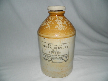
Jug Glazed, 1930s to 1950s
This item was used in conjunction with the Suddeth (Sudden Death) Carbon Bi-siilphide fumigator during many rabbit plagues that invaded Victoria and NSW before CSIRO introduced the myxomatosis virus in 1950.The contents of this jug was very important pre 1950 for all rural areas which suffered under the annual mice plagues, especially the wheat producing regions. Milk producers suffered from the mice by products contaminating their fresh milk containers and storage facilities. Rabbit warrens causing farm machinery instabilities and also horseback activities eg mustering herds.This glazed pottery jug has a screw on lid and a cream coloured body with a caramel brown neck. The remnance of a handle, which has been broken off is located at the top just below the the rim of the lid.On one side below the neck and within a black boundary mark "SUDDETH" and below "SMOKE MIXTURE No. 2" and sandwiched between two black lines "POISON". Below this and in five lines "PATENTED APRIL 6th '08 No. 11205(AUST.)" "PATENTED APRIL 6th '08 No. 24711 (N.Z.)" "THIS MIXTURE GOES IN BOTTLE FURTHEST FROM MACHINE" "DO NOT SPILL ON YOUR HANDS OR CLOTHING" "F, GREER, PATENTEE SYDNEY"ceramic bowls, contamination of farm produce, domestic farm hygiene, vermin extermination poisons -
![View of a Victorian Sheep Station / [by] Nicholas Caire, circa 1876](/media/collectors/550653872162f11fb04854aa/items/577b58dad0cdd10948cfdc7b/item-media/577b5942d0cdd10948d01fbf/item-fit-380x285.jpg) Kew Historical Society Inc
Kew Historical Society IncPhotograph, View of a Victorian Sheep Station, c.1876
Nicholas Caire was born on Guernsey in the Channel Islands in 1837. He arrived in Adelaide with his parents in about 1860. In 1867, following photographic journeys in Gippsland, he opened a studio in Adelaide. From 1870 to 1876 he lived and worked in Talbot in Central Victoria. In 1876 he purchased T. F. Chuck's studios in the Royal Arcade Melbourne. In 1885, following the introduction of dry plate photography, he began a series of landscape series, which were commercially successful. As a photographer, he travelled extensively through Victoria, photographing places few of his contemporaries had previously seen. He died in 1918. Reference: Jack Cato, 'Caire, Nicholas John (1837–1918)', Australian Dictionary of Biography.An original, rare photograph from the series 'Views of Victoria: General Series' by the photographer, Nicholas Caire (1837-1918). The series of 60 photographs that comprise the series was issued c. 1876 and reinforced a neo-Romantic view of the Australian landscape to which a growing nationalist movement would respond. Nicholas Caire was active as a photographer in Australia from 1858 until his death in 1918. His vision of the Australian bush and pioneer life had a counterpart in the works of Henry Lawson and other nationalist poets, authors and painters.Views of Victoria (General Series) No.29 / ‘View of a Victorian Sheep Station’ / Albumen silver photograph mounted on boardOn Reverse: ‘The present illustration is characteristic of a Squatter’s Station in Victoria, and is situated near Elphinstone. In the centre of the picture may be seen the Squatter’s residence or head-quarters surrounded by sheds and out-houses, and in the foreground is a flock of sheep in charge of a lad. Of late years it has become the practice to erect fences around the Australian Sheep Stations, which necessitates only the services of a boundary rider, and dispenses with those of a number of shepherds.’nicholas caire (1837-1918), landscape photography -
 Warrnambool and District Historical Society Inc.
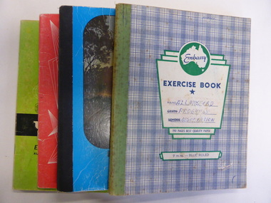
Booklet, Allansford Progress Association, Second half of 20th century
These four exercise books give documentation on the activities of the Allansford Progress Association (1966 to 1988). Allansford is a settlement about 9 kilometres from Warrnambool and most of the town area is now within the boundaries of the Warrnambool City Council. The association was re-formed in November 1966 after the demise of an earlier group. The members of the group campaigned in areas of local concern – T. V. reception, drainage and sewerage, postal services, sports facilities including the development of the Speedway, housing development, road proposals, waste management and disaster plans. These books are of interest in that they provide an overview of the history of a local organization. They will be useful for research. These are four exercise books - three Minutes books, and one Accounts book, from the Allansford Progress Association (1966-1988). The exercise books have coloured covers, (blue and white checkered, green, red and blue). Two are bound with tape and two are stapled. There are some loose sheets in all of the books. All the entries are handwritten. On front covers: ‘Allansford Progress Association’allansford progress association, history of allansford, history of warrnambool