Showing 829 items
matching computers
-
 Ballarat Tramway Museum
Manual, Howard Stoney and Warren Doubleday, "Ballarat Tramways Membership Database - Programme Guide", 1990
Forty page document, with clear plastic front cover, light blue card as rear cover and bound with a plastic comb binder titled "Ballarat Tramways Membership Database - Programme Guide" Version 2.2, dated April 2, 1990. Used at the time to manage the BTPS's Membership database and print labels and reports. Written dBase III+ for use on IBM computers running MS DOS Gives file details, details of the various reports, mail centre codes, and the various sub-programme codes. Has hand written notes noting changes. Programme use until the data base transferred to MS Works/Excel and then managed by Peter Winspur, c1993? various notestrams, tramways, btps, members, manual -
 Melbourne Tram Museum
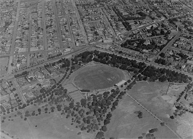
Photograph - Digital Image, Kevin O'Reilly, St Kilda looking east over St Kilda Junction, late 1925
Image from CD (Compact Diskette for use in computers) - see Reg Item 135. Image titled "St Kilda" on CD, of looking east over St Kilda Junction from. Has St Kilda tramway Jtn (St Kilda Road, Fitzroy St, Barkly St, Brighton Road, Wellington St and Punt Road in the photograph, and the "Junction Oval". Mid to late 1925 as workmen are converting the cable track in Fitzroy St and Wellington St looks or appears converted with a crossover installed near the junction. Two cable car sets visible in St Kilda Road, on in Brighton Road and a bus? Also a bus? in Fitzroy St.trams, tramways, st kilda junction, st kilda railway station, fitzroy st, brighton rd, cable trams -
![Map, Ballarat and Gordons Lane Plan of Land required [for railway line work]](/media/collectors/5e461d8021ea67224c82f2a1/items/676ff3a62c3783fe00b96a8d/item-media/676ff4a42c3783fe00b96cb6/item-fit-380x285.jpg) Bacchus Marsh & District Historical Society
Bacchus Marsh & District Historical SocietyMap, Ballarat and Gordons Lane Plan of Land required [for railway line work]
The railway line from Melbourne to Bacchus Marsh was completed in February 1887. After this date work continued to extend the line to Ballan. This map indicates a portion of land only a few hundred metres west of the Bacchus Marsh railway station which would have been among the first stages of the line to Ballan to have been constructed. This suggests the date of this map to be in the late 1880s.Single page map showing land required for railway line work near Griffith Street, Bacchus Marsh. Scale 10 chains to 1 inch. Hand-written on the map are the exact distances between Bacchus Marsh and Gordons (Gordon) and between Bacchus Marsh and Melbourne as measured from the corner of Maddingley Road and Station Street. Distances recorded are in miles, chains and links. The land required for the railway works is marked in red ink and runs through an area known as Kennedy's Gully. Part of a set of maps which are pasted into a bound volume containing 76 maps or plans in total. High resolution digital image stored on BMDHS computer network. bacchus marsh victoria history, maddingley victoria history, railway lines -
 Eltham District Historical Society Inc
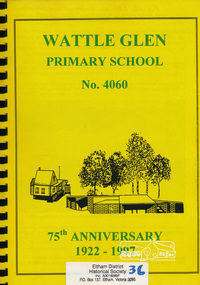
Book, Wattle Glen Primary School No. 4060 - 75th anniversary 1922-1997, 1997
Includes black and white photos and sections: General history of Wattle Glen and surrounding area, gold mining, 4060 Wattle Glen, Opening school buildings (newspaper articles from The Advertiser, 1922), Sunnyside Estate Wattle Glen, Wattle Glen 4060, copies of early documents, parents protest for a new classroom, I remember Wattle Glen School Days (various recollections over various years includes class photographs), Wattle Glen Primary School Today inc. lists of staff and students 1982. Second Section titled: 1997 - 75th anniversary update From the Principal, School Council, Parents Association, Newer memories, computers at Wattle Glen, Past teachers 1983-1997, 1997 classes, memories Kathleen Cuxson, Reunion 1997, Memories of Cyril Cummins (Principal 1950-52), 1997 memories, 1997 update compiled by Naomi Windisch. No page numbers This book is significant in that it documents the history of the Wattle Glen Primary School and its wider community to 1997. It is one of a very few publications written specifically on this rural community within the Shire of Nillumbik.Spiral Bound. Inscribed - For the Eltham Historical Society Collection in exchange for the '1999 Chronology', 27/4/9975th anniversary, state school no. 4060, wattle glen primary school -
 Moorabbin Air Museum
Document (Item) - Various articles, photo's and cards (in some cases multiple copies). See description for more details, Various articles, photo's and cards. See description for more details
Post WW2, PR, brochures , pamphlets, photos, newspaper articles, drawings. Includes G.T. Hudson's Aristo Aviat Flight computer, drawing of S.N.E.C.M.A turbo engine, Notar no tail rotor helicopter, A4 photos of Mustang, Messerschmitt 109, Boeing jet transport design, Dassault Dornier Alpha jet 2, RAN naval aircraft, Yak-Aem 130, Aermacchi MB-339C,Saab 304, geometrical tolerancing BS 308, CA15, Hawker Harrier, Jaguar GR Mk 1, Pratt % Whitney PW4000, 8000, F100 and F117 engines, Saab AJ37 Viggen, F-16, AIAA publications catalog 2004, Micro dot inserts, Kaynar locknuts, K-Fast tools, AH-1 Cobra, F-14, Concorde, SR-71, B-17, XB-70, F-4 Phantom, Panavia tornado, Allison turboprop 250 engine, Gas turbine performance, F-117, -
 Vision Australia
Administrative record - Text, Braille and Talking Book Library 92nd Annual Report 1894-1986: that all may read, 1986
Annual report of the Braille & Talking Book Library including Minutes of the AGM, Board of Director's Report, President's report and financial statements. Items also included are: naming the computer which will store the book catalogue for the library 'Tilly', RVIB declared a public library and Minister for the Arts has determined for services to rationalise with the Chairman and Vice-Chairman meeting their counterparts with meetings ongoing, first time borrowers asked to nominate their choice of winning title for Braille Book of the Year, with the literary panel of Stephen Murray-Smith, Joyce Nicholson and Barrett Reid making a short list from which borrowers voted, first time presentation held in the afternoon (with increased attendence) and inaugural Narrator's Award (The Bathurst in honour of former President Hector Bathurst) to Eirene Pappas, Hector Bathurst to receive OAM, Jan Smark Nilsson appointed to National Advisory Committee on Library Services to People with Disabilities and Australia Post approval to change cassette mailing pouches.1 volume of text and illustrationsbraille and talking book library, annual report -
 Parks Victoria - Wilsons Promontory Lightstation
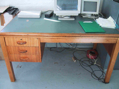
Desk
This fairly substantial wooden desk with vinyl top was issued to Wilson’s Promontory Lightstation by the Department of Public Works in the 1960’s. Primarily the desk was used for correspondence purposes, and now has the Bureau of Meteorology computer stationed on it. Although the design and make of this desk is common to many lightstations across Victoria, it is a good example of the kind of furniture that was provided to Victorian lightstations in the 1960’s. The solidly constructed desk was used in the lightstation office. It is made of honeycoloured hardwood and has a green vinyl top and three drawers on the left side. The style suggests that it may date to the 1960s. Gabo Island Lightstation has two identical desks, and all were probably standard issue from the Commonwealth Lighthouse Service or Public Works Office. Another twentieth century vinyl topped desk at Gabo is manufactured with a steel frame. Cape Nelson, Cape Schanck, Point Hicks and Gabo Island retain nineteenth century cedar desks. The desk at Wilsons Promontory has second level significance as a good example of the style of office furnishing provided to lightstations in the 1960s.Wooden desk with square legs and green vinyl top. It has three drawers with wooden handles on the left . The top drawer has a keyhole. -
 Bendigo Military Museum
Photograph - Johnson Ground Elevation Meter (JGEM) Survey Vehicle - Army Survey Regiment, Fortuna, Bendigo, c1960s
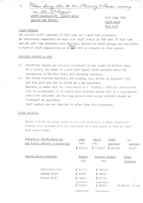
This is a set of 16 photograph of the Royal Australian Survey Corps’ Johnson Ground Elevation Meter (JGEM) Survey Vehicle taken at the Army Survey Regiment, Fortuna, Bendigo. The JGEM vehicle was extensively used by RA Svy within Australia from the late 1960s. A limited number of Ground Elevation Meter (GEM) station wagon type vehicles were manufactured by General Motors Corporation (GMC) in the USA for the United States Geological Survey, Canada’s mapping agencies, RA Svy and National Mapping (Natmap). The GEM was a four-wheel drive, four-wheel steer vehicle. Four-wheel steering was necessary to avoid systematic errors caused by non-tracking of front and rear wheels on conventionally steered vehicles. The manufacturer substituted the rear axle with a front axle and connected them to form the four-wheel steering mechanism. The two Australian GEM vehicles, referred to as Johnson GEMs (JGEMs) were converted into right-hand drive. After delivery in 1964, acceptance Natmap and RA Svy testing and operator training was undertaken at the Army's School of Military Survey located at Balcombe, Victoria. A small fifth wheel was mounted on a cantilever arm suspension midway between the front and rear wheels on the right side of the vehicle. It was lowered to and raised from its operating position by use of a constant pressure air cylinder. A telescopic bar, suspended between the front and rear axles, provided the reference datum for the angle measurement. The wheel provided the velocity or distance signal through a pulse generator system. A sensitive pendulum mounted on this bar provided the angle measurement for each minute distance traversed. The JGEM contained electromechanical instruments used to determine relative elevations, by trigonometric principles, along a traversed path. These relative elevations were obtained through apparatus which measures the instantaneous angle of inclination of the road and the instantaneous velocity of the meter along such a path. Road routes over which the JGEM operated were planned so that each started and ended as near as practicable to an existing point of known elevation (formally referred to as a level traverse bench mark). The difference in height from the bench mark and the road surface alongside the JGEM’s fifth wheel was measured with a level and staff. Along each route, mapping control photo reference points where new elevation values were required were identified on aerial photographs. Under favourable conditions it was possible to survey as much as 160km in an ordinary working day. The first of RA Svy’s JGEM operations was undertaken in 1:250,000 scale map areas of Queensland. CPL John Hook was the JGEM’s main operator in the early 1970s undertaking operations covering 1:250,000 scale map blocks over northern Victoria and central NSW, each requiring 36 points (9 runs of photography and 4 points across. SPR Lyn Thompson and SPR Bob McDonagh teamed with CPL Hook on some of these JGEM operations. When RA Svy was integrated into the Royal Australian Engineers in 1996, the JGEM vehicle with the Survey Corps collection was donated to its museum. It is believed to be the last of the original manufactured fleet in existence. The JGEM has undergone extensive refurbishment to achieve roadworthiness and is currently housed at The Australian Army Museum of Military Engineering, Hoslworthy Barracks, NSW. It can be viewed by making an appointment with the museum’s curator.This is a set of 16 photograph of the Royal Australian Survey Corps’ Johnson Ground Elevation Meter (JGEM) Survey Vehicle taken at the Army Survey Regiment, Fortuna, Bendigo. The photographs were on 35mm slide film and were scanned at 96 dpi. They are part of the Army Survey Regiment’s Collection. .1) - Photo, colour, c1960s, Johnson Ground Elevation Meter (JGEM) Survey Vehicle .2) - Photo, colour, c1960s, JGEM instrumentation, on-board computer. .3) - Photo, colour, c1960s, JGEM instrumentation. .4) - Photo, colour, c1960s, JGEM instrumentation, on-board computer. .5) - Photo, colour, c1960s, JGEM tyre pressure controller .6) - Photo, colour, c1960s, JGEM rear doors, SGT Geoff Briggs. .7) - Photo, colour, c1960s, JGEM 5th wheel distance/angle measurement device in lowered position, SGT Geoff Briggs. .8) - Photo, colour, c1960s, JGEM 5th wheel distance/angle measurement device in lowered position. .9) & .10) - Photo, colour, c1960s, JGEM tyre pressure system, SGT Geoff Briggs. .11) - Photo, colour, c1960s, JGEM tyre pressure system. SGT Geoff Briggs. .12) - Photo, colour, c1960s, JGEM levelling scope, levelling staff, unidentified technicians. .13) & .14) - Photo, colour, c1960s, JGEM levelling scope, unidentified technician. .15) & .16) - Photo, colour, c1960s, probably survey operation adjusted height plotted on block base sheet. .1P to .16P - Some of the equipment is annotated on the frame of the 35mm slides.royal australian survey corps, rasvy, army survey regiment, army svy regt, fortuna, asr, surveying -
 Bendigo Military Museum
Photograph - Royal Australian Survey Corps - Map Production Processes, c1990
This is a collection of 20 photographs of Royal Australian Survey Corps phases of map production at the School of Military Survey, Bonegilla, the Army Survey Regiment, Bendigo, and the Army Map Depot, Bandiana circa 1990. Colour photos are on 35mm slide film and were scanned at 96 dpi. They are part of the Army Survey Regiment’s Collection. Photo .1P was probably taken on a survey station overlooking Lake Hume near Albury-Wodonga. The field party occupying the survey station was likely from a Map Control Survey course conducted by the School of Military Survey, Bonegilla. This survey station was part of a geodetic network used in field survey training and RASvy’s Lake Hume Test Range. Photos .3P to .16P were taken at the Army Survey Regiment, Bendigo and photos .17P & .18P were taken at the Army Map Depot, Bandiana. Photo .19P depicts a map of RASvy’s ARA units before the disbandment of 5th Field Survey Squadron, Perth and 2nd Field Survey Squadron, Sydney in 1990. This is a collection of 20 photographs of map production processes taken at the School of Military Survey, Bonegilla, the Army Survey Regiment, Bendigo, and the Army Map Depot, Bandiana circa 1990. Colour photos are on 35mm slide film and were scanned at 96 dpi. They are part of the Army Survey Regiment’s Collection. Photo .2P is printed on photographic and scanned at 300 dpi. .1) – Photo, colour, c1980s. Geodetic Surveying: AN/PRR-14 Geoceiver antenna on hill surrounding Lake Hume. Series 3 Land Rover, field party tent and survey station beacon in background. .2) – Photo, black & white, c1980s. Geodetic Surveying: AN/PRR-14 Geoceiver antennas set up at the School of Military Survey, Bonegilla, Victoria. .3) – Photo, colour, c1990. Aerotriangulation: Wild PUG4 point transfer device, SSGT Bruce Hammond. .4) – Photo, colour, c1990. Aerotriangulation: Zeiss (Jena) Stecometer, SSGT Bruce Hammond. .5) – Photo, colour, c1990. Aerotriangulation: computer tape maintenance, SSGT Noel McNamara. .6) – Photo, colour, c1990. AUTOMAP 2: computer tape maintenance, SPR Nadine (Paul) Read. .7) - Photo, colour, c1990s. AUTOMAP 2: Optronics 4040 scanning/film output in Lithographic Squadron, SGT Sherri (Dally) Burke. .8) - Photo, colour, c1990s. AUTOMAP 2: Benson verification plotter output, SPR Nadine (Paul) Read. .9) – Photo, colour, c1990. Aerotriangulation: data management, SGT Neil ‘Ned’ Kelly. .10) & .11) - Photo, colour, c1990s. AUTOMAP 2: Wild B8 Aviograph stereoplotter Feature Extraction, unidentified technician. .12) - Photo, colour, c1990s. AUTOMAP 2: Graphic Edit Workstation, SPR Nadine (Paul) Read. .13) - Photo, colour, c1990s. AUTOMAP 2: Graphic Edit Workstation, SPR Dawn Hoadley. .14) & .15) - Photo, colour, c1990s. AUTOMAP 2: Graphic Edit Workstation, unidentified technician. .16) – Photo, colour, c1990s. Heidelberg Speedmaster 102 computer-controlled five colour lithographic offset printing press. .17) & .18) – Photo, colour, c1990s. Army Map Depot, unidentified storeman, Bandiana. .19) – Photo, colour, c1990. RASvy ARA Unit Locations before disbandment of field units in Perth and Sydney. .20) – Photo, colour, c1990. Set of overlapping aerial photography..1P, .3P to .20P - Some equipment is identified on the frame of the 35mm slides.royal australian survey corps, rasvy, army survey regiment, army svy regt, fortuna, asr, school of military survey, army map depot -
NMIT (Northern Melbourne Institute of TAFE)
Brochures: Courses Preston College of TAFE 1984 and 1985
Brochures of varying sizes [1984/1985]. Accounting, Art, Bookkeeper-typist, Building detail drafting Pre-employment program, Business studies, Business TOP, Childcare, Civil Engineering Drafting Survey & Mapping, Computer users certificate, Drama TOP, Electronics, Finished art, General, General studies, Higher school certificate for adults, Management, Mechanical/Electrical detail drafting, Mechanical Engineering Mechanical design drafting, Music, Office & Secretarial studies, Personnel & training officer course, Photography, Piano tuner technician, Physical & natural science, Science laboratory, Sales & Marketing, Secretarial, Secretarial studies, Supervision Certificate, Trades, Other than English brochures X 7 ?Arabic, Greek, Italian, Vietnamese plus others. preston college of tafe, handbooks, brochures, nmit -
 Bendigo Historical Society Inc.
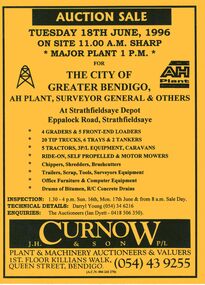
Document - IAN DYETT COLLECTION: AUCTION CATALOGUE - THE CITY OF GREATER BENDIGO
Bright yellow auction catalogue with black printing for a sale on 18th June, 1996 for the City of Greater Bendigo, AH Plant, Surveyor General & Others at Strathfieldsaye Depot, Strathfieldsaye. For sale were Earth moving equipment, tractors, 3 P/L equipment, caravans, various mowers, chippers,shredders, brush cutters, trailers, scrap, tools, Surveyors equipment, office furniture & computer equipment, drums of bitumen and R/C concrete drains. J. H. Curnow & Son P/L were the auctioneers. Map of how to get to auction site inside front cover. Loose pink Supplementary List, account Coliban Water listing backhoe/F.E. loaders, tractor, tipper crane and 4WD wagon listed.business, auctioneers, j h curnow & son pty ltd, ian dyett collection - auction catalogue - the city of greater bendigo, ah plant, surveyor general & others, darryl young, ian dyett, j h curnow & son p/l, coliban water, noel dyett, fred dyett -
 Flagstaff Hill Maritime Museum and Village
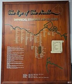
Artwork, other - Shipwreck Board, The Eye of the Needle: Shipwrecks, Stranding's and Collisions, ca 2002
The Shipwreck Board is a feature of Flagstaff Hill Maritime Museum and Village/ its subject is explained briefly in the Museum's handbook, The Flagstaff Hill Navigator, published in 2008: - "Known as the ‘Eye of the Needle’ the treacherous entrance to Bass Strait is littered with the wreckage of large international vessels and smaller sail and steam craft used in coastal trade. The vessels bringing emigrants and cargo to Australia found the western entrance to Bass Strait the most dangerous part of their voyage. They had to thread their way between the southern point of Victoria (Cape Otway) and the northern point of King Island, a stretch of water less than 90 km wide. Many smaller coastal vessels were lost at Portland, Port Fairy, Warrnambool and Apollo Bay which are not safe harbours in certain weather conditions. "The Shipwreck Board shows shipwrecks, strandings and collisions which occurred in this area up to the year 1940. Wrecks are identified by a yellow light and collisions/strandings by a green light. These lights also identify the decade the wreck occurred by lighting up when the relevant decade button is pushed. Interesting happenings of the decades are listed next to the buttons." The Shipwreck Board's demonstration of The Eye of the Needle is an interactive visual display that helps teach the perils and dangers faced by early settlers in Victoria. It tells of the vast number of lives lost. It lists the names of many infamous shipwrecks and significant events.The large stained and lacquered timber board is mounted in a timber, frame. It is painted with a small sketch of Australia, and an enlarged outline of the southern coast of Victoria, King Island and the North West coast of Tasmania. The interactive display highlights the shipwrecks, standings and collisions suffered by many vessels as they navigated the 'Eye of the Needle', a narrow stretch of Bass Strait. The locations of the Lighthouses are pinpointed. Lists of groups of ships are below the coastlines. A painted scroll shows eight major shipwrecks with the number of lives lost for each one. A table shows historical facts associated with the decades from pre-1830 to 1940. A system of coloured lights compares the decades with the vessels that suffered damage. The board was created by artist and signwriter, Alex O'Flynn Computer Signs.flagstaff hill, maritime museum, maritime village, shipwreck coast, eye of the needle, shipwreck locations, bass strait, basses strait, king island, north west tasmania, south coast of victoria, cape otway, victorian lighthouse, king island lighthouse, strandings, coastal tracers, emigrant ships, sea trade, 1930s-1940s, shipwreck board, the eye of the needle, collosions, alex o'flynn, alex o’flynn computer signs, shipwrecks of western victoria -
 Bendigo Military Museum
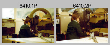
Photograph - Capturing Topographic Features with a Wild B8, AUTOMAP 1 Systems Operations – Army Survey Regiment, Fortuna, Bendigo, 1980
This is a set of 24 photographs of Air Survey Squadron technicians capturing topographic Features with a Wild B8 stereo plotter and operating AUTOMAP 1 equipment at the Army Survey Regiment at Fortuna, Bendigo, 1980. 17 of these photographs were taken of SPR Nick Van Dalen and SPR Santina (Argetto) Straube capturing topographic features – plotting with a Wild B8 stereo plotter were most likely taken in 1980. See item 6185.4P for black & white copies of photos of SPR Santina (Argetto) Straube operating the Wild B8 stereo plotter. Refer to item 6204.8P for detailed information and additional photographs of the Wild B8 stereo plotter. The history of the AUTOMAP 1 system is covered in more detail with additional historic photographs in pages 116-118 of Valerie Lovejoy’s book 'Mapmakers of Fortuna – A history of the Army Survey Regiment’ ISBN: 0-646-42120-4. See items 6122.20P, 6183.19P, 6184.20P, 6200.5P, and 6222.17P for additional photographs of the AUTOMAP 1 system.This is a set of 24 photographs of Air Survey Squadron technicians capturing topographic features with a Wild B8 stereo plotter and operating AUTOMAP 1 equipment at the Army Survey Regiment at Fortuna, Bendigo, c1980. The photographic proofs were printed on photographic paper and are part of the Army Survey Regiment’s Collection. The photographic proof prints were scanned at 600 dpi. .1) to .8) Photo, black & white, 1980. SPR Santina (Argetto) Straube operating a Wild B8 stereo plotter. .9) to .17) Photo, black & white, 1980. SPR Nick Van Dalen operating a Wild B8 stereo plotter. .18) to .24) Photo, black & white, 1980. CPL Gerry Gunn undertaking AUTOMAP 1 computer system duties..1P to .24P – no annotations.automap 1, royal australian survey corps, rasvy, army survey regiment, army svy regt, fortuna, asr, photogrammetry -
 Bacchus Marsh & District Historical Society
Map, Atkins and Clarke Land Sale situate at Bacchus Marsh 1856 Copy 2
This plan of land allotments for sale indicates the property once owned by the Bacchus family in and around the township area of Bacchus Marsh. The Bacchus family sold their property in Bacchus Marsh to John Atkins and Robert Nalder Clarke in March 1851. Atkins and Clarke kept the property for a number of years until April 1856 when these allotments were put up for sale.This plan is almost identical to another copy held by the Bacchus Marsh and District Historical Society, VC Record 707, BMDHS collection). This plan, VC Record 452 Copy 2, contains a less detail than than VC Record 707 Copy 1. For example the selling agents and the surveyor who created the plan are not indicated on this copy of the plan. This copy of the plan does indicate the name Crook Street on the map. As the Crook family were the buyers of the Manor House property and surrounding land from Atkins and Clarke in 1856 it suggests that this copy is a later one of the earlier version. It is unlikely that the Crook family would have had the adjacent street named after them prior to purchasing the house and property. This is a very early land sales plan for the township of Bacchus Marsh and it therefore provides some clues as to how the early urban development of the township took place. Upon seeing the map in 1911 Bacchus Marsh Express newspaper editor Christopher Crisp wrote "The sale appears to have created the present township, which had a nucleus in earlier times further east", Express, 30 September, 1911, page 3. A single page paper map showing a portions of land available for sale in Bacchus Marsh in 1856. The subdivided land shown was owned by John Atkins and Robert Nalder Clarke, but previously owned by the Bacchus Family and was in and around their Manor House (Mansion) property in Bacchus Marsh.There are 5 portions of land further divided into numerous small portions. The land for sale is bounded by the present day streets of Main Street, Young Street, McFarland Street, Morton Streets, Crook Street, and part of the eastern section extends to the Lerderderg River. Scale: 4 chains to 1 inch. The map is pasted into a bound volume containing 76 maps or plans in total. High resolution digital image stored on BMDHS computer network. Plan of the first portion of land. The property of Messers Atkins and Clarke situate at Bacchus Marsh.land sales, land sales bacchus marsh, manor house bacchus marsh, crook family bacchus marsh -
 Bacchus Marsh & District Historical Society
Map, Plan of the second portion of the property of Messers Atkins and Clarke situate at Bacchus Marsh 1856
This plan of land allotments for sale indicates part of the property once owned by the Bacchus family in and around the township area of Bacchus Marsh. The Bacchus family sold their property in Bacchus Marsh to John Aitkins and Robert Nalder Clarke in March 1851. Aitkins and Clarke kept the property for a number of years until April 1856 when these allotments were put up for sale.This is a very early land sales plan for agricultural land close to the township of Bacchus Marsh. It therefore provides some clues as to how the early urban development of the township and agricultural development of the nearby area took place. Upon seeing the map in 1911 Bacchus Marsh Express newspaper editor Christopher Crisp wrote "The sale appears to have created the present township, which had a nucleus in earlier times further east", Express, 30 September, 1911, page 3.A single page paper plan showing allotments of land for sale. The subdivided land shown was owned by John Aitkins and Robert Nalder Clarke, but previously owned by the Bacchus Family and was in and around their Manor House (Mansion) property in Bacchus Marsh. This plan shows allotments in the second portion of land to be sold which was located east of the Manor House on the eastern side of the Lerderderg River. The land for sale was made up of 15 allotments. The plan is pasted into a bound volume containing 76 maps or plans in total. BMDHS Loc: AR/B12/S4 Bacchus Marsh Township and Nearby Districts Maps Volume In-house Digital copies: BMDHS, Computer Network: Maps\Bacchus Marsh Township and Nearby Districts Maps Volumebacchus marsh victoria maps, bacchus family, land sales, manor house bacchus marsh -
 Bendigo Military Museum
Photograph - Photo Troop Equipment and Personnel, Lithographic Squadron, Army Survey Regiment, Fortuna, Bendigo, 1960s and 1970s
This collection of 14 photos were taken at Lithographic Squadron, Army Survey Regiment, Fortuna, Bendigo probably in the 1960s and 1970s. The main tasks undertaken by technicians in Photo Troop were most likely enlargements, reductions and duplication of map reproduction material, and processing of aerial photography. The equipment operated by the technicians is the KLIMCH camera. The main tasks undertaken by the technicians were most likely enlargements and reductions of map reproduction material. The KLIMSCH Commodore camera was introduced in 1953 and was the largest in the Southern Hemisphere. It was replaced with a new model of the same size in 1979. The new model with its computer-based interface provided productivity gains with improved speed and its consistent results led to less wastage in time and materials. See items 6057.8P, 6056.11P and 6058.8P for more information and photos on Photo Troop equipment and personnel. There is more information on the KLIMSCH Commodore camera, on pages 70 and 120 of Valerie Lovejoy’s book 'Mapmakers of Fortuna – A history of the Army Survey Regiment’ ISBN: 0-646-42120-4. This collection of 14 photos were taken in Photo Troop, Lithographic Squadron, Army Survey Regiment, Fortuna, Bendigo probably in the 1960s and 1970s. The photographs were printed on photographic paper and are part of the Army Survey Regiment’s Collection. The photographs were scanned at 300 dpi. .1) - Photo, black & white, 1960s, KLIMSCH Commodore camera, unidentified technicians. .2) - Photo, black & white, 1960s, KLIMSCH Commodore camera, unidentified technician. .3) - Photo, black & white, 1960s, KLIMSCH Commodore camera. .4) - Photo, black & white, 1960s, KLIMSCH Commodore camera, unidentified technician. .5) - Photo, black & white, 1960s, KLIMSCH Commodore camera. .6) - Photo, black & white, 1960s, KLIMSCH Commodore camera, unidentified technicians. .7) - Photo, colour, 1970s, KLIMSCH Commodore camera, unidentified technicians. .8) - Photo, black & white, 1970s, WILD U4A Diapositive Camera, SPR Garry Hudson. .9) - Photo, black & white, 1970s, Photographic camera enlarger, SPR Garry Hudson. .10) - Photo, black & white, 1970s, Photographic camera enlarger, Phil Beaty. .11) - Photo, black & white, 1979, Film developer, SGT Garren Hill. .12) - Photo, black & white, 1970s, Film contact frame. .13) - Photo, black & white, 1970s, LogEtronics Contact Printer. .14) - Photo, black & white, 1970s, Tri-stud registered map separations with composite black negative on top.No personnel are identified. .11P annotated ‘1979’. .13P and .14P annotated ‘orthophoto’royal australian survey corps, rasvy, army survey regiment, army svy regt, fortuna, asr, litho -
 Bendigo Military Museum
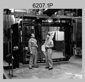
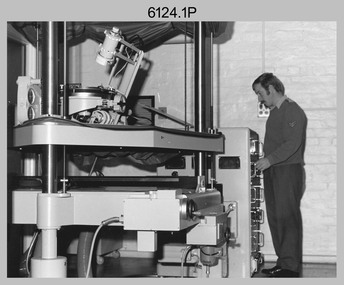
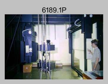
photograph - Orthorectification Equipment - Army Survey Regiment, Fortuna, Bendigo, c1975
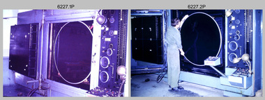
Orthophoto mapping provided the Survey Corps with the capability to produce map products quickly in the event of a crisis. These are four photographs of equipment used by the Army Survey Regiment to produce orthophotomaps. The Wild GZ1 orthophoto projector was introduced in 1973 and was the first equipment used to orthorectify colour and monochrome film aerial photography. Height profiles were originally produced on a PEB8 Stereo profiler and later were software generated. Photos of the PEB8 are available in Victorian Collections item 6222.17P, photos .5P and .6P. In the same era the IBM 1130 computer; OMI/Nistri AP/C-3 analytical plotter with coordinatograph, OP/C orthophoto projector and Zeiss Planimat D2 stereoplotters were introduced. Orthorectification is the process of removing geometric distortions and scale errors/variations from images. Images have tilt and relief distortions that make it difficult to compare accurately a map and an image of the same geographic area. Once an image is orthorectified, features on the image are shown in their planimetric locations. These four photographs of orthorectification equipment were taken at the Army Survey Regiment at Fortuna, Bendigo, c1975. Photo .1P and .3P were printed on photographic paper and scanned at 300 dpi. Photos .2P, .4P and .5P were on 35mm negative film and scanned at 96 dpi. They are part of the Army Survey Regiment’s Collection. .1) - Photo, black & white, c1975, Wild GZ1 orthophoto projector operated by CPL Phil Boyle. .2) - Photo, black & white, c1975, Wild GZ1 orthophoto projector. .3) - Photo, black & white, c1975, Wild GZ1 orthophoto projector. .4) - Photo, black & white, c1978, Zeiss D2 Planimat Stereoplotter. .5) - Photo, black & white, c1978, Zeiss D2 Planimat Stereoplotter..1P to .5P No annotations.royal australian survey corps, rasvy, army survey regiment, army svy regt, fortuna, asr -
 Bendigo Military Museum
Photograph - Photographic Technicians operating the KLIMSCH Camera at the Army Survey Regiment, Fortuna, c1980s
These four photographs were most likely taken in the mid-1980s in Lithographic Squadron at the Army Survey Regiment, Fortuna, Bendigo. The equipment operated by the technicians is the KLIMSCH camera. The main tasks undertaken by the technicians were most likely enlargements and reductions of map reproduction material. The KLIMSCH Commodore camera was introduced in 1953 and was the largest in the Southern Hemisphere. It was replaced with a new model of the same size in 1979. The new model with its computer-based interface provided productivity gains with improved speed and its consistent results led to less wastage in time and materials. Its variomat lens system provided improved retention of map feature linear weights during the camera reduction process. The camera which was specially made for the Army in Germany was fully automatic and power operated. It was claimed to be one of the biggest automatic cameras of its type in the world. It was made to the specifications of the Royal Australian Army Survey Corps to assist in the production of the very high standard maps for the Army. This is a set of four photographs of technicians operating the KLIMSCH Camera at the Army Headquarters Survey Regiment, Bendigo c1985. The photographs were on 35mm negative film and scanned at 96 dpi. They are part of the Army Survey Regiment’s Collection. .1) Photo, black & white, c1985, Frank Lenane operating the KLIMSCH Camera. .2) - Photo, black & white, c1985, KLIMSCH Camera. .3) to .4) - Photo, black & white, c1985, John Whaling operating the KLIMSCH Camera..1P to .4P – no annotationroyal australian survey corps, rasvy, army survey regiment, army svy regt, fortuna, asr, litho -
 Flagstaff Hill Maritime Museum and Village
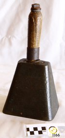
Functional object - Bell, Probably second half of 19th Century or first half of the 20th Century for this particular item
The school bell has been used in various forms for several centuries. In Australia and the UK it was often a hand bell, located on the teacher's desk in a small school. In larger schools it was positioned in a central area, and one bell was used to signal to all classrooms. In North America it was more usual to find a large bell on a stand located in a central area of the school where it could be heard by everyone throughout the premises. More recently, the school bell has become wall located, and electrically activated, using a mechanical timing apparatus. Now the same bell is computer programmed and activated, although there are many older bells still in operation. The school bell was rung at the beginning at the school day, often to summon students to the morning assembly in larger schools. It was then rung throughout the day to signal the start and end of specific lesson periods, the beginning and end of school morning and afternoon breaks, the lunch period, and the end of the school day, no doubt eagerly awaited by many students! The school bell was used as a timing device in schools to signal the start and end of specific activities.Bell brass with heavy metal square shaped base and wooden handle-hand held, Kel(?)her Melbourne on the topInscribed on the metal at the top of the bell are the letters "Kel(?)her Melbourne" flagstaff hill, warrnambool, shipwrecked-coast, flagstaff-hill, flagstaff-hill-maritime-museum, maritime-museum, shipwreck-coast, flagstaff-hill-maritime-village, bell, school, lessons -
 Melbourne Legacy
Document - Document, report, Staff Organisation Legacy House Present and Future. 20/7/1990, 1990
Legacy staff numbers when this document was written in 1990 were 28 full time staff and 5 part time. In 1982 there were 31 full time and 1 part time. The report discusses increasing the hours of a clerk/typist, not re-appointing a person to replace The Senior Pensions Advocate and a new appointment with computer skills. Wages increased by 53.3%. The wage increase was in line with award rates. Salaries rose by 51.8% from June1983 to April 1990. The report also discusses staff leave, work environment, staff morale and adequacy of office equipment. The future (3-5 years) was discussed in regard to pensions, welfare, housing accommodation for widows and handicapped dependants and fund raising. Location to be checked TBA There were a number of suggestions as to how to maintain current activities and not employ extra staff. The question was asked " Should we now in 1990 be encouraging our Executive Officer to make greater input on our decision making and be given greater resposibility"?Melbourne Legacy has been continually discussing and updating its programe and procedures to maintain its relevance.White foolscap paper with black type, 5 pages about staff organisation.staff, planning -
Bendigo Historical Society Inc.
Photograph - Aerial shots of parts of Bendigo 1934, 1934
AERIAL SHOTS OF PARTS OF BENDIGO 1934 Catalogue No.10584 This document contains scans of a unique set of aerial photographs that were taken over the City of Bendigo on Friday 12th January 1934, at about midday. The photographs were commissioned by Bendigo Mines Limited during their exploration and mining program designed to revitalize the Bendigo Goldfield. The photographs were given to the Victorian Mines Department sometime in the 1950s. The photographs were taken at a relatively low level of about 4000 feet. This gives a very detailed picture of Bendigo as it was in the 1930s. The photos cover the City Centre and are mainly of the goldfields on the south side of the city; the extent of which covers approximately the four corners of Myers Flat, Maiden Gully, Mandurang and One Tree Hill. Streets, roads and places of interest have been identified as best as possible in December 2023. There are 44 maps, and each references the adjoining maps.Typed Notes with CD The CD is one of two and contains a set of 46 images: The folder named "High_Resolution_800dpi" contains the original digital files that were produced by scanning the photographic prints (About A3 size) at 800 dpi using a high quality, large pformat, roll scanner. These files may be too large for some computers. A second CD contains a direstory called "Low_Resolution_300dep" The images in the folder names "Low_Reolution_300dpr" have a lower resolution (300 dpi) and have been rotated 90 degrees clockwise so that the Northern margin of each image is a the top of the screen. Clive Willman Senior Geologist Geological Survey of Victoriahistory, bendigo, bendigo mines, bendigo maps, bendigo aerial photos -
 Bendigo Military Museum
Photograph - Typesetting Equipment and Personnel, Army Survey Regiment, Fortuna, Bendigo, c1968 to 1979
This is a set of nine photographs of cartographic typesetting equipment and personnel in Cartographic Squadron at the Army Survey Regiment, Fortuna, Bendigo circa 1968 to 1979. The rooms on the top floor of Fortuna Villa where the photos were taken were formally the nursery and boys bedrooms during the Lansell family’s occupation of the building. The Fotosetter type setting machine replaced the letterpress method of type production in 1956. Its operator entered the text using a type order provided by cartographic draughtsmen/ draughtswomen. The type was output on a film positive, which was contacted onto strip film. The text was cut out by cartographic draughtsmen/ draughtswomen and affixed onto type sheets using bees wax. Cartographic Squadron’s CPL Arty Lane specialised in the operation of the Fotosetter type setting machine for many years, as shown in photos .3P and .4P. For more information on the Fotosetter, see page 71 of Valerie Lovejoy’s book 'Mapmakers of Fortuna – A history of the Army Survey Regiment’ ISBN: 0-646-42120-4. The computer based Editwriter Model 7500 typesetting system was introduced in 1975 as a replacement to the aging Fotosetter. It was operated by a specialised technician, who generated a large variety of map type styles and sizes quickly and reliably, as well as text panels. Output on Copy proof adhesive backed stripping type film replaced messy wax and spray adhesives in 1978. The Editwriter capability supported all RASvy units and its contractor type setting requirements. SGT Jim McDonald operated the Editwriter for a couple of years in the late 1970’s. He is seen in photos .7P and .8P. reading off a type order and entering text into the computer. See item 6181.23P, photo .1P for a reduced scale photo of SGT Jim McDonald undertaking this task. Also see item 6123.12P photos .1P and .2P featuring CPL Paul Richards, who was another technician that operated the Editwriter for several years in the 1980s. The Editwriter was also operated by SSGT Pat Lumsden, as featured in photo .9P taken in 1979. The Monotype Photolettering Machine seen in photos .5P and .6P is understood to be in service for a shorter period, as it was not as productive compared to the Fotosetter and Editwriter. This is a set of nine photographs of cartographic typesetting equipment at the Army Survey Regiment, Fortuna, Bendigo, c1968 to c1979. Black and white photos are on photographic paper and scanned at 300 dpi. .1) - Photo, black & white, c1960s, Fotosetter type setting machine, unidentified technician. .2) - Photo, black & white, c1960s, Fotosetter type setting machine. .3) to .4) - Photo, black & white, c1968, Fotosetter type setting machine, CPL Arty Lane. .5) to .6) - Photo, black & white, c1970s, Monotype Photolettering Machine, unidentified technician. .7) to .8) - Photo, black & white, c1979, Typesetting machine, ‘Editwriter’ Model 7500, SGT Jim McDonald. .9) - Photo, black & white, 1979, Typesetting machine, ‘Editwriter’ Model 7500, SSGT Pat Lumsden.Personnel and equipment are identified in photos .1P to .3P. on a card. A description is provided: ‘Fotosetter: This model was used from 1956 to 1974. Where photograph was taken: Army Survey Regiment. Person in Photograph: Arty Lane. Approx date photograph taken: 1968. Any Misc Information: All type on maps was set on this machine. The operator of the machine (Ex SGT Lane) joined the Army in 1956 and was discharged in 1977. Also with Survey from 1942 to 1946. Information given by: Arty Lane’. Photo .9P is dated 1979 on the back.’royal australian survey corps, rasvy, army survey regiment, army svy regt, fortuna, asr, carto -
Federation University Historical Collection
Annual Report, Ballarat School of Mines Annual Report, 1970
The Ballarat School of Mines was founded in 1970 and was the first institution of formal technical education in Australia. 1970 marked the centenary of the School and that of technical Education in Australia. A centenary commitee was established to plan activities and projecty sot celebrate the occasion. These included five centenary lectures fro secondary school students, a film of the School to be made and shown on National Television, a centenary medallion centenary posters, a dinner for local organisations with Council and staff as hosts, an historical notebook on the school, a plaque mounted to mark the site of the original school, opening of the Mt Helen Campus, Relocating the Old SMB battery ot mt Helen, student reunion, Art display of present and former students, Mt Helen Open Days and distribution of car stickers. A Centenary Appeal was established to finance a Great Hall and Sports Centre at the Mt Helen Campus. The Appeal President was Cr W.J.C. North. The materials testing laboratory secured and retained registration by the National Association of Testing Authorities for a range of tests on concrete and metals. The student accommodation at Mt Helen 23 Page report (with supplementary finances) in a soft cover showing a picture of the Former Ballarat Circuit Courthouse which was used as the first building of the Ballarat School of Mines. The report includes a page of stamps produced to commemorate the centenary of Technical Education in Australia through the Ballarat School of Mines. The report was presented by Council President Morgan Bevan John. The report includes information on the new campus for the Tertiary Division at Mt Helen, including information on the buildings being constructed by local builders. The site plan was developed by G.J. Harrison and L.H. Vernon and Associates. The following staff resigned: E.R. McGrath (deceased), E.W. Ryan, I.L. Hunter. The following new appointments were made: R.l. Martin, G.K. Tampi, T.F. Norwood, K.M. Llewellyn, M.J. Evans, J.F. Clark, K.G. Millar, B.R. Rollins, L.G. Shome, C.I. Dowling, M.H. Pitfield, G.M. Pearson, J.P. Murray, J.R. Thyer. Page 10 lists diplomas awarded and page 11 lists scholarships and prizes including the Ballarat has Company Scholarship, the Josephine Brelaz Scholarship, The Frank Pinkerton Scholarship, The Mica Smith/Serjeant/Ironworkers Scholarship, Martha Pinkerton Scholarship, Ballarat City Council Scholarship, Junior Art Scholarship, C.R.A. Scholarship, B.H.P. Scholarship, S.E.C. Scholarship, Alexander Rushal Scholarship, Russell and Shirley Evans Scholarship. The R.W. Richards Medal for 1969 was awarded to Peter Hensley. A new I.C.L. 1901A computer and associated equipment was purchased for the Computer Centre. Page 15 has information on the Victorian Institute of Colleges (VIC). Governor of Victoria, Sir Rohan Delacombe, with VIC's Dr Philip Law visited the Ballarat School of Mines and inspected both the old and new facilities. ballarat school of mines, m.b. john, centenary, anniversary -
 Orbost & District Historical Society
black and white photograph, Snowy River Mail, October 1987
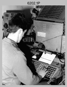
This a photograph of the Gippsland representatives at the C.A.T.S. conference. This photograph was taken at the Curriculum and Technology in Schools workshop held in Bendigo, Victoria in October 1987. Eighty rural primary schools were involved including many from East Gippsland. From the Snowy River Mail; " A large number of technologies was......demonstrated at the conference. Participants were given hands on experience with audio and computer conferencing, CD Rom. an Invicon booth ( individual video console (INVICON) enables any teacher to produce short, relevant teaching videos for individual pupils without assistance), packet radio, videodisk, robotics and many more...." In the back row are: Al Balfour (Bairnsdale Min of E); Graeme Rodier (OHS); Roger Nink (Swifts Creek); John Hillier (Mallacoota); Barry Lay ( Bairnsdale HS); Ross Burn ( Bairnsdale HS), In the front row are: Jeff Wilson (Mallacoota); Bea Lay (Bairnsdale HS); Rick Box ( Swifts Creek) and Brian Pomeroy (AVRB Bairnsdalel). Al Balfour was a noted educator, local identity and one of country Victoria's strongest advocates.This is a pictorial record associated with education in East Gippsland.A black / white photograph of a group of people. The back row is standing and the front is sitting on chairs.education-east-gippsland technology -
 Bendigo Military Museum
Photograph - Photographic Technicians operating the KLIMSCH Camera at the Army Survey Regiment, Fortuna, Bendigo, c1988
These nine photographs were most likely taken in c1988 in Lithographic Squadron at the Army Survey Regiment, Fortuna, Bendigo. The equipment operated by the technicians is the KLIMCH camera. The main tasks undertaken by the technicians were most likely enlargements and reductions of map reproduction material. The KLIMSCH Commodore camera was introduced in 1953 and was the largest in the Southern Hemisphere. It was replaced with a new model of the same size in 1979. The new model with its computer-based interface provided productivity gains with improved speed and its consistent results led to less wastage in time and materials. Its variomat lens system provided improved retention of map feature linear weights during the camera reduction process. The camera which was specially made for the Army in Germany was fully automatic and power operated. It was claimed to be one of the biggest automatic cameras of its type in the world. It was made to the specifications of the Royal Australian Army Survey Corps to assist in the production of the very high standard maps for the Army. There are several more photos catalogued in the Victorian Collections database of RA Svy personnel operating the KLIMSCH camera.This is a set of four photographs of technicians operating the KLIMSCH Camera at the Army Headquarters Survey Regiment, Bendigo c1988. The photographs are on 35mm colour slides scanned at 96 dpi. They are part of the Army Survey Regiment’s Collection. .1) - Photo, colour, c1988, KLIMSCH Camera. .2) - Photo, colour, c1988, KLIMSCH Camera, unidentified technician. .3) - Photo, colour, c1988, KLIMSCH Camera. .4) - Photo, colour, c1988, KLIMSCH Camera, L to R: SPR Shona Hastie, CPL Paul Baker. .5) - Photo, colour, c1988, KLIMSCH Camera. .6) & .7) - Photo, colour, c1988, KLIMSCH Camera, SPR Shona Hastie. .8) & .9) - Photo, colour, c1988, KLIMSCH Camera, SPR Russell Pajank.35mm colour slides are in good condition.rasvy, royal australian survey corps, army survey regiment, army svy regt, fortuna, asr, litho sqn -
 Bendigo Military Museum
Photograph - First Topographic Map Printed on Speedmaster Press - Army Survey Regiment, Fortuna, Bendigo, c1992
This is a photograph of the Director Survey - COL Simon Lemon, CO Army Svy Regt - LTCOL Bob McHenry and probably OC Litho - MAJ Terry Lord inspecting the 1St topographic map printed on the new Heidelberg Speedmaster 102 Printing Press in c1992. *Estimated date based on the Director’s and CO’s period of appointment. The computer-controlled five colour lithographic offset printing press provided the Royal Australian Survey Corps vastly improved printing capability, as the five colours for a standard topographic map was printed in a single pass. The print room was named Wayzgoose Hall after a medieval printing house festival. Wayzgoose Hall and the Speedmaster printing capability was commissioned by the Commander of the 3rd Military District BRIG P. Davies AM, ADC on Wednesday 27th June 1990. This occasion is covered in more detail in page 145 of Valerie Lovejoy’s book 'Mapmakers of Fortuna – A history of the Army Survey Regiment’ ISBN: 0-646-42120-4. Colonel Simon Lemon was Director of the Royal Australian Survey Corps from January 1991 to June 1996.This is a photograph of three senior RASvy officers inspecting the first topographic map printed on the Heidelberg Speedmaster 102 Printing Press in Lithographic Squadron, Army Survey Regiment, Fortuna, Bendigo, c1992. The photograph is on 35mm black and white negative film and was scanned at 96 dpi. It is part of the Army Survey Regiment’s Collection. No personnel are identified. royal australian survey corps, rasvy, army survey regiment, army svy regt, fortuna, asr -
 Melbourne Legacy
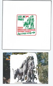
Document, Lest YOU forget. Legacy cares for Australia's biggest family, 1990
This is an example of Melbourne Legacy promotional material. It is possibly prepared for the 1990 campaign. It was in a folder with marketing material from the 1990s. It is a draft from a graphic designer of a logo and the photo that the image was based on. The image was from a postcard and white-out was used to masque the background. It was a manual process before computer design software was commonplace. The slogan "Lest YOU forget" was used with an image of the statue of Simpson and his donkey rather than a personality in 1990 (recycling the slogan from 1989). Possibly to bring the focus back onto the service given to Australia by service men and women. The main time of year for fundraising is September when Legacy holds 'Badge Week'. Often there is a celebrity who gives his or her time as 'Personality of the Year'. Examples are Sir Weary Dunlop (1992), Clive James (1993), the Scott family (1994), The Emmanuel brothers (1995), Daryl Somers (1996 and 1997), and Patsy Adam Smith (1994?). Was in a folder with marketing material from the 1990s to 2009, see items 01240 to 01258. The collection shows the types of marketing materials that were produced and the celebrities that were helping Legacy.An example of promotional material from the 1990s. Marketing material and photos were compiled and released to newspapers, also printed as brochures and sometimes as stickers and collection tin wrappers. This draft shows a method of producing marketing material by graphic designers at a time when design software was a niche program that few people had access to.Colour draft of a promotional image for Legacy Week, featuring the statue of Simpson and his donkey.legacy promotion, badge appeal, legacy week -
 Bacchus Marsh & District Historical Society
Map, Plan of the property of Messers Atkins and Clarke to be sold at the Mansion, Bacchus Marsh 19th April 1856. Copy 1
This plan of land allotments for sale indicates the property once owned by the Bacchus family in and around the township area of Bacchus Marsh. The Bacchus family sold their property in Bacchus Marsh to John Atkins and Robert Nalder Clarke in March 1851. Atkins and Clarke kept the property for a number of years until April 1856 when these allotments were put up for sale.This plan is almost identical to another copy held by the Bacchus Marsh and District Historical Society, VC Record 452, BMDHS collection). This plan, VC Record 707 Copy 1, contains a little more detail overall than VC Record 452 Copy 2, such as who did the survey work for the plan (R.C. Bagot) and who the selling agents were, (W.M. Tennent), and on the right side of the plan near the Lerderderg River is indicated the general area for a second parcel of land from this sale which is to be sold. There is also a compass illustration indicating north and south compass points.This is a very early land sales plan for the township of Bacchus Marsh and it therefore provides some clues as to how the early urban development of the township took place. Upon seeing the map in 1911 Bacchus Marsh Express newspaper editor Christopher Crisp wrote "The sale appears to have created the present township, which had a nucleus in earlier times further east", Express, 30 September, 1911, page 3.A single page paper plan showing allotments of land for sale. The subdivided land shown was owned by John Atkins and Robert Nalder Clarke, but previously owned by the Bacchus Family and was in and around their Manor House (Mansion) property in Bacchus Marsh.There are 5 portions of land further divided into numerous small portions. The land for sale is bounded by the present day streets of Main Street, Young Street, McFarland Street, Morton Streets, Crook Street, and part of the eastern section extends to the Lerderderg River. Scale: 8 chains to 1 inch The plan is pasted into a bound volume containing 76 maps or plans in total. BMDHS Loc: AR/B12/S4 Bacchus Marsh Township and Nearby Districts Maps Volume In-house Digital copies: BMDHS, Computer Network: Maps\Bacchus Marsh Township and Nearby Districts Maps VolumeHeading: Plan of the first portion of land. The property of Messers Atkins and Clarke situate at Bacchus Marsh. To be sold by W.M. Tennent & Co. at the Mansion on the Ground on Saturday the 19th April 1856. Below heading: Jas Ferguson, Lithographer On upper right side: Subdivided by R.C. Bagot London and Liverpool Chambers, Melbourne. 'Thos Taubman'. Post Office Stamp: BACCHUS MARSH VICTORIA MY 6, 63bacchus marsh victoria maps, bacchus family, land sales, manor house bacchus marsh -
 Bendigo Military Museum
photograph - Cartographic Squadron Production – Army Survey Regiment, Fortuna, c1980
This collection of 12 photos was most likely taken in 1980. The photos were most likely taken in Cartographic Squadron’s Ante Room, the Attic and small offices on the top floor of Fortuna Villa. The computer based Editwriter typesetting system was introduced in 1975 as a replacement to the aging Fotosetter machine. It was operated by a specialised technician, who generated a large variety of map type styles and sizes quickly and reliably, as well as text panels. CPL Richards performed this task for several years and in photo .1P and .2P is reading off a type order next to the computer monitor. Output on Copy proof adhesive backed stripping type film replaced messy wax and spray adhesives in 1978. The Editwriter capability supported all RASvy units and contractor type setting requirements. Scribing was the cartographic process of drafting features such as drainage, relief, vegetation, roads and culture on specially coated map reproduction material. The cartographic technician scribed out the map feature such as a contour to a specified line width on the map sheet, using a tool affixed with a sapphire tipped cutter. The quality control edit (Proving) stage of map production was the first opportunity to inspect a proof of the map independently and systematically. Proving tasks were carried out by technicians conversant of the map product specification and task requirement, however, was not involved in its production. Corrections were identified, marked up and sent to back to the correcting section or contractors. Terrain Embossing was a manual map production technique to produce hill shading on medium to small scale graphics and air charts. SPR John Martin is seen in photos .8P to.10P using a fine embossing metal stylus to push down on the drainage impression on a thin malleable opaque plastic material (AK Poligraphy). Ridge lines were then pushed down using the contour impression as a guide, on the opposing side of the AK Poligraphy to create a 3D plastic model terrain effect. The map impression was sprayed with white paint and photographed to create a contone tone hill shade. SPR Gina (Coore) Neilson is seen in photo .11P washing a contone positive of a land mass in a solution. The contone components were registered to the map sheet, as shown in photo .12P and masked using an air brush and a halftone negative was then created. The terrain embossing method of producing hill shading was more efficient to produce than previous specialised artistic methods such pencil/eraser and air brush. Furthermore, a more consistent enhancement of terrain on charts was achieved between technicians.This is a set of 12 photographs of Cartographic Squadron performing four map production tasks at the Army Survey Regiment, Fortuna, Bendigo c1980. The first ten photographs were on 35mm negative film and were scanned at 96 dpi. Photos .11P and .12P were on photographic paper and scanned at 300 dpi. They are part of the Army Survey Regiment’s Collection. .1) - Photo, black & white, c1980, Editwriter typesetter, CPL Paul Richards. .2) - Photo, black & white, c1980, Editwriter typesetter, CPL Paul Richards. .3) - Photo, black & white, c1980, Scribing contours on a RAAF Chart, SPR Megan (McBurney) Reynolds. .4) - Photo, black & white, c1980, Scribing contours on a RAAF Chart, SPR Megan (McBurney) Reynolds. .5) - Photo, black & white, c1980, Scribing contours on a RAAF Chart, SPR Rod Skidmore. .6) - Photo, black & white, c1980, Scribing contours on a RAAF Chart, SPR Rod Skidmore. .7) - Photo, black & white, c1980, Formal quality control edit (Proving), CPL Ian Belmont. .8) - Photo, black & white, c1980, Hill Shade Terrain Embossing, SPR John Martin. .9) - Photo, black & white, c1980, Hill Shade Terrain Embossing, SPR John Martin. .10) - Photo, black & white, c1980, Hill Shade Terrain Embossing, SPR John Martin. .11) - Photo, black & white, c1980, Hill Shade Terrain Embossing, SPR Gina (Coore) Neilson. .12) - Photo, black & white, c1980, Hill Shade Terrain Embossing, unidentified..1P to .10P No personnel are identified. .11P and .12P annotated ‘Terrain Embossing’royal australian survey corps, rasvy, army survey regiment, army svy regt, fortuna, asr, carto -
Glen Eira Historical Society
Article - Murrumbeena Cricket Club
MURRUMBEENA CRICKET CLUB HISTORY (1890-2005) by David Hardham, thirty-four pages printed from computer of the history of the Club, with photographs and accounts of major players and figures, dated January 2005. MURRUMBEENA CRICKET CLUB HISTORY by David Hardham, fifteen pages printed from computer of the history of the Club, dated October 2002. No photographs. Also includes a CD, submitted by David Hardham, with the text of the 2002 history, and photograph of THE PETER ROBERTSON OVAL sign Large and small black and white photocopies of photograph of THE PETER ROBERTSON OVAL sign, with persons standing underneath, no date but possibly from late 1930s Collection of EPHEMERA TO ADD TO MURRUMBEENA CRICKET CLUB’S FILE, THEIR CENTENARY CELEBRATIONS, 21/11/2010. Includes invitation to attend dinner, with information about payment options and sales of club memorabilia. Murrumbeena Cricket Club, Inc Annual Report, Season 2002-2003, foutry-eight page pamphlet with historical lists of office bearers, and results of matches in 2002-2003. Includes lists of RECORDED NOTABLE PERFORMANCES, FROM SEASON 1945-55 by John Dennis, Club Historian ‘BEENA QUINELLA clipping from Caulfield/Port Phillip Leader, 17/05/2010, an recent match SEVEN UP FOR POYAS AS SAINTS HAVE THEIR WAY WITH MORDI, clipping from Caulfield/Port Phillip Leader, 24/05/2011, includes recent match by Murrumbeena, and VAMPIRES RISE, SAINTS DRAINED, clipping from Caulfield/Port Phillip Leader, 31/05/2011, notes that MURRUMBEENA HAD THE BYE. Paul Amy, IT’S BEENS TOP TON, clipping from Caulfield/Port Phillip Leader, 16/11/2010, article on forthcoming Club 100th Anniversary Dinner, with photograph of Club STALWARTS David Hartham, Don McDermott and Leigh Hardham. Paul Amy, SIR DONS LAST STAND, clipping from Caulfield/Port Phillip Leader. 13/03/2012, on Don McDermott, member of the Club for sixty years, includes photograph PORT’S DAY KIN FINDS FORM WITH CLASSY CENTURY, from Glen Eira/Port Phillip Leader, 06/11/2012, includes recent match by Murrumbeena against Chelsea Brad Beitzel, WICKETS FALL BUT PORT STILL A CHANCE, clipping from Glen Eira/Port Phillip Leader, 26/02/2013, notes recent match by Murrumbeena against Cheltenham FOUR DAY MATCH SHOULD YIELD A RESULT, clipping from Glen Era/Port Phillip Leader, 19/03/2013, notes loss in match by Murrumbeena to Brighton Districtmurrumbeena cricket club, murrumbeena, sporting clubs, cricket clubs, armstrong j.r., riley t.j., robertson p.t., watson j.f., glenie f., armstrong f., backman e.r., bristowe l.l., moore r., ridgeway j.j., schrape f., walker t., wolsley e., forscutt a., whelan f., rundell c.m., berry j., gilbert j.j., watson a.j., kirk t.e., schrape a.j., mcalister j.w., watson e.a., williams v.j., hardham m.f., hindmarsh j., stevens b.t., macwhirter j.c., harbour n.l., mcdermott j.a., watson k.g., graham a.m., johnston d.c., white p.o., mcdermott r.e.s., pugh g.h., trevethan w.j., macwhirter d.j., blaze r.e., healy d.l., hidson p.e., way p.j., hardham d.m., mcdermott d.a., dennis j.r., hardham. l.a., wilkinson d.j., graham j.e., gifford s., goold s.c., walker i.l., harbour mrs e., newton p.s., weaver d.a., fielder j.g., hay g.i., paton a., hay s.j., bailes j., gray j., dutton w., gray r., martin s., martin j., horton m., pugh v., west j., day e.j., wilde w.j., watson j.f., watson a.j., hanna r., butler w.g., wanliss t.n., cooke a.r., coghill r.g., ryan g.m., parker r.j., hayes h.j., hay p.g., de laine g., thompson h., dick r.l., rees v., burns g.m., crook mr., day w.e., cooper h., day e.j., mudge l.v., wilde w.j., cooper a.k., pellissier m.t., hardham mrs g.l., blum p.a., allamby d., smale r., mark j., hancock s., kivell d., fitts b., murphy d., roach a., walker w., jayasuriya k., driver w., gilbert j.a., hiland p., vandersluys m., singelton w., mcnabb j., taylor b., burne n.