Showing 706 items matching "economic"
-
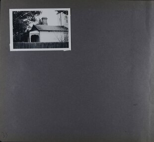
 Orbost & District Historical Society
black and white photographs, April 1916
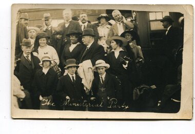
These photographs were taken at the official opening of the Orbost - Bairnsdale Railway Line. In 3150.3 which is of a group of children and two adults those identified in the photograph are ; L - R front row Mary Gilbert; Warren; Betty Gilbert; Marion Gilbert; Mrs Shaw and son; ? Gay; and Pen Gilbert. In 3150.4 L-R front " Mary Gilbert; Bet Gilbert (sitting with glasses); Pen Gilbert(Richardson); Marion Gilbert ( middle front little girl) About 1912 work began at Newmerella on clearing the track for the railway line from Bairnsdale to Orbost. A canvas town sprang up on the higher land adjacent to the river flats. Local farmers supplied meat, milk and fresh produce to the camp, as well as gaining employment carting and labouring. The line opened in 1916, the Orbost railway station being built on the Newmerella side of the river.This item is associated with the history of the Orbost-Bairnsdale railway line and therefore reflects the role that the rail line played in the social and economic history of Orbost. It is a pictorial record of a significant event in Orbost's history. On April 10 1916, the first scheduled train service left Orbost for Bairnsdale. The Bairnsdale-Orbost railway was opened to serve the agricultural and timber ndustry. Because of the decline in traffic and heavy operating costs, the line was finally closed in August, 1987. Four black / white postcards of people at the opening of The Orbost - Bairnsdale Railway. 3150.1 - on front - "The Ministerial Party" 3150.2 - on front - hand-written - " The Hon James Cameron" with arrow pointing to a man standing in the back row. at bottom - "The Ministerial Party X Florie Cameron" on back- "Opening the Orbost Railway" 3150.3 and 3150.4 - on back - hand-written "First train to Orbost with a list of names.orbost-bairnsdale-railway celebration-opening-of-railway east-gippsland-railway -
 Orbost & District Historical Society
black and white photographs, second half 20th century
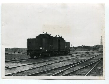
3151.1 is of a water tanker on stand by at Orbost ready for emergency use. Similar suppliers were at Bairnsdale and Nowa Nowa. The two tankers hels about 9,000 gallons (34068.7 litres) - from a news item in "Gippsland" September, 1971. 3151.2 is of Victoria's X class 1,800 H.P general purpose diesel electric locomotive. Si had been ordered for the Victorian Railways and cost about £ 250,000 each. 3151.3 is of several loaded, covered railway trucks on a rail line. 3151.4 was taken at the goods yard at Orbost Railway Station. 3151.5 has some rail wagons with "SHOWMOBILE COUNCIL OF ADULT EDUCATION" on the sides. 3151.6 is of goods wagons (Probably not at Orbost Station) 3151.7 is a goods train 3151.8 shows the loading or unloading of farm produce at Orbost railway Station. 3151.9 shows cattle being loaded at Orbost Railway Station. 3151.10 is of a container N.Y.K. LINE ( a Japanese shipping company) This item is associated with the history of the Orbost-Bairnsdale railway line and therefore reflects the role that the rail line played in the social and economic history of Orbost.Ten black / white photographs related to Orbost rail. orbost-railway east-gippsland-railway transport-railway railway-engine orbost-railway-station export-produce -
 Orbost & District Historical Society
black and white photographs, C 1981
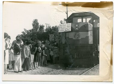
The Bairnsdale-Orbost railway was opened in 1916 to serve the agricultural and timber industry. Because of the decline in traffic and heavy operating costs, the line was finally closed in August, 1987. The closure of this railway was a controversial issue at the time with many public protests in the district. Protesters stood in front of a VR locomotive holding up signs with " SAVE FUEL JOBS ROADS LIVES ORBOST MR HAMER DON"T LET THIS HAPPEN SAVE RAIL" Others held placards with "DON"T CUT OFF ORBOST" and "We the Children demand our ????secure railway"This item is associated with the history of the Orbost-Bairnsdale railway line and therefore reflects the role that the rail line played in the social and economic history of Orbost. The closure of the line was a significant event in Orbost's history.Seven black / white photographs related to the closure of the Orbost Railway Line.orbost-railway east-gippsland-railway protests-rail-closure -
 Orbost & District Historical Society
black and white photographs, second half 20th century
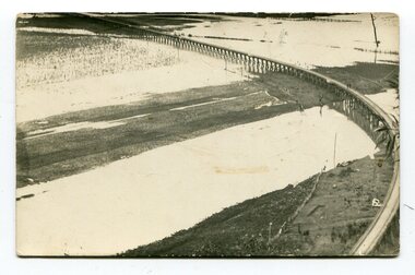
3154.1 is a postcard of the Orbost viaduct over the flooded Snowy River flats. 4153.2 is of a goods train on the viaduct. 3154.3 is of a loaded goods train with the driver at the window. Two men are standing on the plate and there are two workers below where there is some water and flood debris. 3154.4 is of amachine moving flood debris on the rail line. 3154.5 shows flood damage to the viaduct across the Snowy River flats. Two men are driving a dozer.This item is associated with the history of the Orbost-Bairnsdale railway line and therefore reflects the role that the rail line played in the social and economic history of Orbost.Five black / white photographs associated with the Orbost railway line during a flood.orbost-railway east-gippsland -railway orbost-floods -
 Orbost & District Historical Society
black and white photographs, 20th century
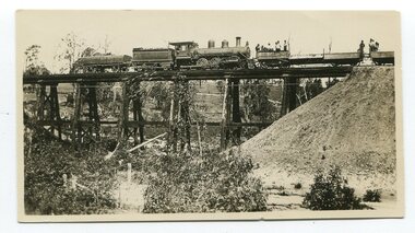
These photographs are probably of bridges on the East Gippsland railway line. 3162.2 is possibly Hospital Creek and 3162.3 possibly Burn Road Newmerella. The Orbost-Bairnsdale railway initially played a crucial role in developing agricultural industries in Gippsland as well as tourism. It opened in 1916 and operated until 1987, principally carrying timber and farming produce. In the early days of the railway's operation dedicated passenger trains ran but these ceased by the 1930s. The line was completely closed to freightage in 1987.The track infrastructure was dismantled in 1994 and has been redeveloped as the East Gippsland Rail Trail.These photographs are associated with the history of the Orbost-Bairnsdale railway line and therefore reflects the role that the rail line played in the social and economic history of Orbost. Three black / white photographs of railway bridges. 3162.1 has a steam train on the bridge. 3162.3 shows three men on the right working at clearing vegetation. 3162.3 has been taken from a height.orbost-bairnsdale-railway east-gippsland-railway bridges-railway -
 Orbost & District Historical Society
Book, The Iron Horse Stopped at Orbost Railway Station, 2019
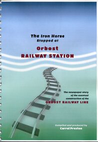
Carrol Preston has used newspaper references from 1877 through to 1917, to document the history of the Orbost - Bairnsdael railway line.. It starts with the lobbying and jockeying, and moves through to the opening in 1916. The title is a reference to plans to further extend the railway beyond Orbost - but "The Iron Horse stopped at Orbost Railway Station". Most articles are from the Snowy River Mail and Bairnsdale Advertiser. All newspaper articles are dated and sourced. About 1912 work began at Newmerella on clearing the track for the railway line from Bairnsdale to Orbost. A canvas town sprang up on the higher land adjacent to the river flats. Local farmers supplied meat, milk and fresh produce to the camp, as well as gaining employment carting and labouring. The line opened in 1916, the Orbost railway station being built on the Newmerella side of the river.This item is associated with the history of the Orbost-Bairnsdale railway line and therefore reflects the role that the rail line played in the social and economic history of Orbost. On April 10 1916, the first scheduled train service left Orbost for Bairnsdale. The Bairnsdale-Orbost railway was opened to serve the agricultural and timber industries. This book has been compiled by a local historian. A spiral bound book titled, "The Iron Horse Stopped at Orbost Railway Station". The cover is blue / green with the title in black and red print. Underneath is a railway track leading to the bottom of the page. The book is 110 pages, A4 size and contains maps and photos. in black print on cover - "The Iron Horse Stopped at Orbost Railway Station ; The newspaper story of the eventual construction of the ORBOST RAILWAY LINE (in red print); Compiled and produced by CARROL PRESTON (in white print)railway-transport orbost-bairnsdale-railway east-gippsland-railway -
 Orbost & District Historical Society
railways envelope, C 1980's
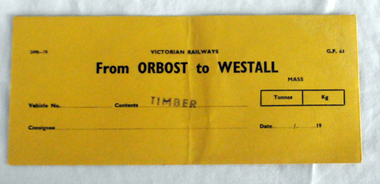
This item was used by Victorian Railways 1970's/1980's. It was used at Orbost Railway Station for the consignment of timber from Orbost to Westall.. Westall was a major timber-receiving depot near Dandenong, Victoria. Westall railway station is located on the Pakenham and Cranbourne lines in Victoria, Australia. It serves the south-eastern Melbourne suburb of Clayton South, opening on 6 February 1951. Westall station was opened as a workers only platform on 16 October 1954. It was provided for the adjacent Martin & King railway coachbuilding factory. The station was opened to the public on 1 June 1959 when all trains on the line began stopping there. The Bairnsdale-Orbost railway was opened in 1916 to serve the agricultural and timber industry. Because of the decline in traffic and heavy operating costs, the line was finally closed in August, 1987. Orbost Railway Station was opened on Monday 10 April 1916 as the terminus of the Orbost railway line, and closed in 1987. The station was located on the west side of the Snowy River despite the town of Orbost being on the east side of the river, in order to save on the costs of a bridge over the river, which at the time had highly variable levels. This item is associated with the history of the Orbost-Bairnsdale railway line and therefore reflects the role that the rail line played in the social and economic history of Orbost.An unused brown/buff coloured goods/freight consignment envelope used by Victorian Railways, this one for timber from Orbost to Westall. It is DL size.2497-78 VICTORIAN RAILWAYS G.F 63 From ORBOST to WESTALL MASS Tonnes kg Vehicle No Contents TIMBER Consignee Date orbost-bairnsdale-railway westall -
 Orbost & District Historical Society
pencils, 1960's
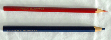
These pencils were supplied to the Orbost railway Station office to be used for clerical work. They were used by Victor Smithers who was the Assistant Station Master at Orbost from 1957 - late 1960's. He was also a reliever until the 1970's after which he returned to Ormond Station on the Frankston line where he worked until his death in 1979. The Bairnsdale-Orbost railway was opened in 1916 to serve the agricultural and timber industry. Because of the decline in traffic and heavy operating costs, the line was finally closed in August, 1987. Orbost Railway Station was opened on Monday 10 April 1916 as the terminus of the Orbost railway line, and closed in 1987. The station was located on the west side of the Snowy River despite the town of Orbost being on the east side of the river, in order to save on the costs of a bridge over the river, which at the time had highly variable levels. This item is associated with the history of the Orbost-Bairnsdale railway line and therefore reflects the role that the rail line played in the social and economic history of Orbost.Two coloured pencils. 2580.1 is a hexagonal blue pencil and has "Wolff's Emperor MADE IN AUSTRALIA". 2580.2 is a round red pencil with "Wolff's Fintorex MADE IN AUSTRALIA coloured copying". Both have "VICTORIAN RAILWAYS" marked in gold lettering on the sides. orbost-railway-station smithers-victor -
 Orbost & District Historical Society
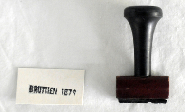
stamp, C 1960's
This stamp was used at the Orbost Railway Station. The Bairnsdale-Orbost railway was opened in 1916 to serve the agricultural and timber industry. Because of the decline in traffic and heavy operating costs, the line was finally closed in August, 1987. Orbost Railway Station was opened on Monday 10 April 1916 as the terminus of the Orbost railway line, and closed in 1987. The station was located on the west side of the Snowy River despite the town of Orbost being on the east side of the river, in order to save on the costs of a bridge over the river, which at the time had highly variable levels This item is associated with the history of the Orbost-Bairnsdale railway line and therefore reflects the role that the rail line played in the social and economic history of Orbost.A stamp with a black plastic handle. The bottom is wood and the stamp rubber. It has "BRUTHEN 1879" on it."BRUTHEN 1879"orbost-railway-station -
 Orbost & District Historical Society
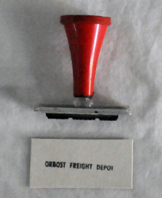
stamp, 1970's
This stamp was used at the Orbost Railway Station. The Bairnsdale-Orbost railway was opened in 1916 to serve the agricultural and timber industry. Because of the decline in traffic and heavy operating costs, the line was finally closed in August, 1987. Orbost Railway Station was opened on Monday 10 April 1916 as the terminus of the Orbost railway line, and closed in 1987. The station was located on the west side of the Snowy River despite the town of Orbost being on the east side of the river, in order to save on the costs of a bridge over the river, which at the time had highly variable levels, This item is associated with the history of the Orbost-Bairnsdale railway line and therefore reflects the role that the rail line played in the social and economic history of Orbost.A stamp with a red plastic handle and a white stamping face - "ORBOST FREIGHT DEPOT".VUESTAMP AUSTRALIAorbost-railway -
 Orbost & District Historical Society
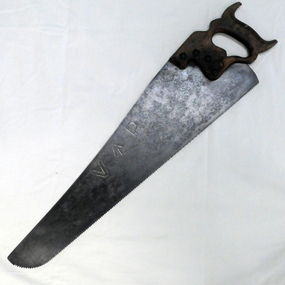
handsaw, C mid 20th century
The Bairnsdale-Orbost railway was opened in 1916 to serve the agricultural and timber industry. Because of the decline in traffic and heavy operating costs, the line was finally closed in August, 1987. Orbost Railway Station was opened on Monday 10 April 1916 as the terminus of the Orbost railway line, and closed in 1987. The station was located on the west side of the Snowy River despite the town of Orbost being on the east side of the river, in order to save on the costs of a bridge over the river, which at the time had highly variable levels. This item is associated with the history of the Orbost-Bairnsdale railway line and therefore reflects the role that the rail line played in the social and economic history of Orbost.A handsaw with a wooden handle and a metal blade with serrated teeth which continue around the nose of the blade.Marked V an upward pointing arrow Rsaw carpentry orbost-bairnsdale-railway orbost-railway-station -
 Orbost & District Historical Society
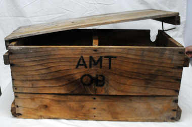
box, first half 20th century
This box was used by Lindsay Thomson's mother, Annie M. Thomson for the transport of hen eggs from Orbost to Melbourne by rail - C 1940's -1950's. The Bairnsdale-Orbost railway was opened in 1916 to serve the agricultural and timber industry. Because of the decline in traffic and heavy operating costs, the line was finally closed in August, 1987. Orbost Railway Station was opened on Monday 10 April 1916 as the terminus of the Orbost railway line, and closed in 1987. The station was located on the west side of the Snowy River despite the town of Orbost being on the east side of the river, in order to save on the costs of a bridge over the river, which at the time had highly variable levels. This item is associated with the history of the Orbost-Bairnsdale railway line and therefore reflects the role that the rail line played in the social and economic history of Orbost. A wooden box with two inside sections and a wooden lid which is secured on both ends by large nails/spikes which are fitted into a groove and are then turned. On front and back in black stencilled letters A M T O B container railway eggs -
 Orbost & District Historical Society
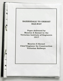
document in folder, Bairnsdale to Orbost Railway Paper Delivered by Maurice Kernot 1917, March 2016
This item was made for the Orbost Railway 100 Years Exhibition held at Orbost in March, 2016. It is a copy of an original paper delivered by Maurice Kernot to the Victorian Institute of Engineers in 1917. Maurice Edwin Kernot was the vice president and managed the construction of the Bairnsdale-Orbost Railway in 1912. The Bairnsdale-Orbost railway was opened in 1916 to serve the agricultural and timber industry. Because of the decline in traffic and heavy operating costs, the line was finally closed in August, 1987.This item is associated with the history of the Orbost-Bairnsdale railway line and therefore reflects the role that the rail line played in the social and economic history of Orbost.Seventeen pages of photocopied document in a black plastic folder. The pages are in separate sleeves. On the back is a price sticker $1 flat file Marbig Single - Red Orbost Authorid News.orbost-bairnsdale-railway east-gippsland-railway kernot-maurice railway -
 Orbost & District Historical Society
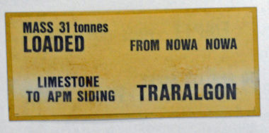
label / sign, 1970's -1980's
This item was used by Victorian Railways in 1980's. It was inserted onto the side of railway freight wagons. The Bairnsdale-Orbost railway was opened in 1916 to serve the agricultural and timber industry. Because of the decline in traffic and heavy operating costs, the line was finally closed in August, 1987. Orbost Railway Station was opened on Monday 10 April 1916 as the terminus of the Orbost railway line, and closed in 1987. The station was located on the west side of the Snowy River despite the town of Orbost being on the east side of the river, in order to save on the costs of a bridge over the river, which at the time had highly variable levels This item is associated with the history of the Orbost-Bairnsdale railway line and therefore reflects the role that the rail line played in the social and economic history of Orbost.A double -sided rectangular shaped label / sign, heavily laminated.Black print on light brown background. On one side : "MASS 31 tonnes LOADED; FROM NOWA NOWA; LIMESTONE TO APM SIDING; TRARALGON". On reverse : "EMPTY FROM TRARALGON; TO APM LIMESTONE SIDING ; NOWA NOWA".freight orbost-bairnsdale-railway -
 Orbost & District Historical Society
documents, 29.5.1963 - September 1963
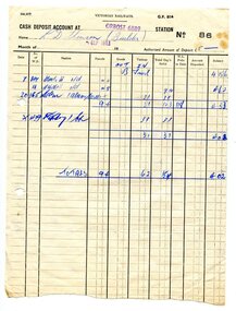
These documents were written and prepared for Lindsay Thomson, Scott Street, Orbost. The correspondence is for costing of freight delivered for use by Lindsay as a builder.These documents are associated with the history of the Orbost-Bairnsdale railway line and therefore reflects the role that the rail line played in the social and economic history of Orbost.Seven documents relating rail freight. Two are cash deposit accounts to Lindsay Thomson from Victorian Railways. There is correspondence and receipts referring to the rail freight. Both typed and hand-written information.2609.1 on back handwritten in pen "L D Thom(p)sonthomson-lindsay railway-freight accounts -
 Orbost & District Historical Society
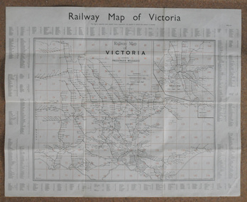
map, Railway Map of Victoria, 1.8.1965
The Bairnsdale-Orbost railway was opened in 1916 to serve the agricultural and timber industry. Because of the decline in traffic and heavy operating costs, the line was finally closed in August, 1987.This item is associated with the history of the Orbost-Bairnsdale railway line and therefore reflects the role that the rail line played in the social and economic history of Orbost.A large rectangular shaped paper map of all railway stations in Victoria. It is dated 1st August 1965. It is divided into grids. Stations are listed around the map. A key is provided and each station has a grid reference.map-railway victorian-railways -
 Orbost & District Historical Society
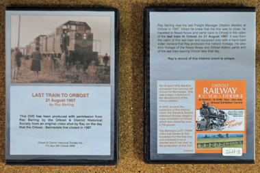
D.V.D. s, Last Train to Orbost, 21.8.1987
These are copies of an original video shot by Ray Barling on the day that the Orbost-Bairnsdale line closed in 1987. He used a hand-held video camera from his cabin on the train, The video was shown at the 2016 Centenary Exhibition in Orbost. The Bairnsdale-Orbost railway was opened in 1916 to serve the agricultural and timber industry. Because of the decline in traffic and heavy operating costs, the line was finally closed in August, 1987. Orbost Railway Station was opened on Monday 10 April 1916 as the terminus of the Orbost railway line, and closed in 1987. The station was located on the west side of the Snowy River despite the town of Orbost being on the east side of the river, in order to save on the costs of a bridge over the river, which at the time had highly variable levels. This item is associated with the history of the Orbost-Bairnsdale railway line and therefore reflects the role that the rail line played in the social and economic history of Orbost. On April 10 1916, the first scheduled train service left Orbost for Bairnsdale. The Bairnsdale-Orbost railway was opened to serve the agricultural and timber industry. Because of the decline in traffic and heavy operating costs, the line was finally closed in August, 1987. Orbost Railway Station was opened on Monday 10 April 1916 as the terminus of the Orbost railway line, and closed in 1987. The station was located on the west side of the Snowy River despite the town of Orbost being on the east side of the river, in order to save on the costs of a bridge over the river, which at the time had highly variable levels, The video was shown for the first time at the Centenary Exhibition held in Orbost, by the Orbost & District Historical Society, t created much interest leading to the production of the videos.Two copies of a D.V.D. titled"Last Train To Orbost 21 August 1987". The cover is a photo of the last train.rail-closure orbost-bairnsdale-railway -
 Orbost & District Historical Society
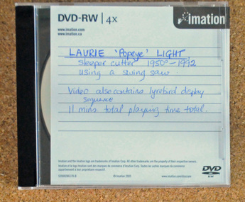
D.V.D, Laurie Popeye Light, 1950-1992
The video shows Laurie LIght, a sleeper cutter for 42 years, using a swing saw. There is also a video of a lyre bird display. Laurie Light was born on May 12, 1938 to parents, Arthur Vernon Light and Nellie Hall. He started work with his father, a sleeper cutter for the Victorian Railways, at the age of 16. (More info. from newsletter LAURIE LIGHT, SLEEPER CUTTER - Heather Terrell)This item is associated with the history of the Orbost-Bairnsdale railway line and therefore reflects the role that the rail line played in the social and economic history of Orbost. It is also associated with the timber industry of East Gippsland.A D.V.D. of pictures and a video on Laurie Light, a sleeper cutter from 1950-1992. The disc is in a clear plastic case with a black insert. It is a copy of the original. this copy was probably made in 2016.On disc in red marker : "LAURIE LIGHT SLEEPER CUTTING with swing saw and lyre bird display"sleeper-cutting light-laurie timber-industry-orbost -
 Orbost & District Historical Society
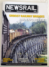
magazine, NEWSRAIL Vol 44 Issue 4 April 2016, April 2016
Established in 1945, the Australian Railway Historical Society Victorian Division Inc. has a proud history of over 70 years of catering for all who have an interest in the railway history of Victoria. It has a membership of over 500 members throughout Australia and overseas. This item was donated at the Centenary of the Orbost - Bairnsdale Railway exhibition held in Orbost April 2016. This item is a record of the the history of the Orbost-Bairnsdale railway line and therefore reflects the role that the rail line played in the social and economic history of Orbost. A magazine/booklet titled, NEWSRAIL. It is Vol. 44 Issue 4 dated April, 2016. There is an article on 'Orbost Railway Bridges. The magazine has a cost of $9.50. On the front cover is a coloured photograph of a train passing over the Wairewa trestle bridge on the Bairnsdale - Orbost line. -
 Australian National Surfing Museum
Poster, Somewhere Near Tapachula, 1/1/2010 (estimated)
This poster was used to promote the Australian release of SOMEWHERE NEAR TAPACHULA February-April 2010. The film was shot on location in Tapachula, Mexico near the Guatemala border and tells the story of the orphanage Mision Mexico exstablished by two Australians Alan and Pamela Skuse. Surfing was introduced to the children at the orphanage in 2004 and surfing has now become an important part of the weekly program but has also played a key role in improving the lives of the children in the orphanage. SOMEWHERE NEAR TAPACHULA is a unique surfing documentary which explores the social impact of surfing on a community of children living in a Mexican orphanage run by two Australians. Through a series of interviews the film follows the lives of a number of the children as they struggle with issues of identity, family and the harsh economic reality of growing up in a poor Mexican coastal town. Surfing is their one physical and emotional 'escape' refuge.Full colour poster for the surf documentary film SOMEWHERE NEAR TAPACHULA. The poster features an image of a young girl with a surfboard at her feet standing on a beach staring at the ocean.Full colour poster featuring title, film sponsors and Australian tour dates (2010)surfing, somewhere near tapachula, surf film, mexico, jonno durrant, stefan hunt, mision mexico, alan skuse, pam skuse -
 Eltham District Historical Society Inc
Photograph, Warrandyte Post Office, c.1972, 1972
The weatherboard building was built in the 1870s. It operated as a post office from 1876-1972. In 1988, the Warrandyte Historical Society took over the building and created a museum - https://whsoc.org.au/who-we-are/Of regional significance as an early building demonstrating the typical characteristics of early timber structures, and for its historical importance as the only relatively intact building in the town's main street dating from the gold mining period. It is also of local social significance for its important and continuing associations with the social and economic life of the town for over 100 years. - Victorian Heritage DatabaseDigital TIFF file Scan of 9 x 12.5 cm black and white printwarrandyte post office, telephone box, weatherboard house -
 Eltham District Historical Society Inc
Photograph, Warrandyte Post Office, c.1972, 1972
The weatherboard building was built in the 1870s. It operated as a post office from 1876-1972. In 1988, the Warrandyte Historical Society took over the building and created a museum - https://whsoc.org.au/who-we-are/Of regional significance as an early building demonstrating the typical characteristics of early timber structures, and for its historical importance as the only relatively intact building in the town's main street dating from the gold mining period. It is also of local social significance for its important and continuing associations with the social and economic life of the town for over 100 years.- Victorian Heritage DatabaseDigital TIFF file Scan of 9 x 12.5 cm black and white printwarrandyte post office, telephone box, post office -
 Eltham District Historical Society Inc
Photograph, Warrandyte Post Office, c.1972, 1972
The weatherboard building was built in the 1870s. It operated as a post office from 1876-1972. In 1988, the Warrandyte Historical Society took over the building and created a museum - https://whsoc.org.au/who-we-are/Of regional significance as an early building demonstrating the typical characteristics of early timber structures, and for its historical importance as the only relatively intact building in the town's main street dating from the gold mining period. It is also of local social significance for its important and continuing associations with the social and economic life of the town for over 100 years.- Victorian Heritage DatabaseDigital TIFF file Scan of 9 x 12.5 cm black and white printwarrandyte post office -
 Glen Eira Historical Society
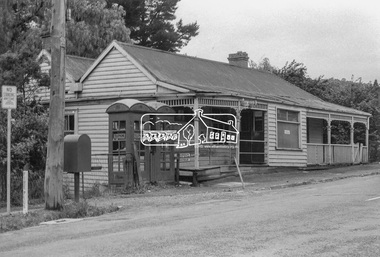
Album - Album page, Railway Avenue (ie Railway Parade), Circa 1972
This photograph is part of the Caulfield Historical Album 1972. This album was created in approximately 1972 as part of a project by the Caulfield Historical Society to assist in identifying buildings worthy of preservation. The album is related to a Survey the Caulfield Historical Society developed in collaboration with the National Trust of Australia (Victoria) and Caulfield City Council to identify historic buildings within the City of Caulfield that warranted the protection of a National Trust Classification. Principal photographer thought to be Trevor Hart, member of Caulfield Historical Society. Most photographs were taken between 1966-1972 with a small number of photographs being older and from unknown sources. All photographs are black and white except where stated, with 386 photographs over 198 pages. From Victorian Heritage Database citation for HO57 Alnwick, 11 Railway Parade Murrumbeena https://vhd.heritagecouncil.vic.gov.au/places/35369 as at 30/10/2020 Alnwick" is situated at no. 11 Railway Parade, Murrumbeena, and was built for Sir James Patterson, former Commissioner of Public Works and Railways and Premier and Chief Secretary at the time. It is historically and aesthetically significant. It is historically significant (Criterion A) as the home of a former Premier and MLA who held a multitude of senior positions during his term of office spanning between 1870 and 1895. These positions included Commissioner of Public Works, Vice President of the Board of Land and Works, Postmaster General, Commissioner of Railways and Commissioner of Trade and Customs and Minister of Railways. Importantly, he held these offices during the period of Colonial expansion leading up to the economic crash of the early 1890s. It is aesthetically significant (Criterion E) as an early example of the Queen Anne style in Glen Eira and as an isolated early building facing the railway station in Murrumbeena.Page 170 of Photograph Album with one photograph of a house on Railway Avenue.Handwritten: Railway Avenue [top right] / 170 [bottom right]trevor hart, chimneys, verandah, porch, 1890's, alnwick, railway parade, sir james patterson, james patterson, single storey, murrumbeena station, red brick, gable, murrumbeena, railway avenue, victorian style, house names, queen's avenue, queen anne style, protruding bay windows, premiers, polychrome bricks -
 Glen Eira Historical Society
Article - Rosstown Railway
This file contains three items: 1/A review of the ROSSTOWN RAIL TRAIL from LIVING IN GLEN EIRA, vol. 11, 2004, Issue 4, no. 25, date and author unknown. The review explains the purpose of the Rail Trail with a brief narrative of the history behind Rosstown Sugar Mill Railway line. Concluding with information on the location of the Trail and the expected time required to walk the entire track included in the review is a map of the Rail Trail, which marks significant sites along the trail with historic pictures. 2/A newspaper article from THE AGE, dated Tuesday 21/10/1980 and written by Iola Matthews, reporting on the circumstances that led to the publication of the book RETURN TO ROSSTOWN written by Des Jowett and Ian Weickhardt. The article begins with a brief biography of the authors before moving into details of the book’s content, providing a further biography of W. Murray Ross which includes information on his financial ventures – particularly the Rosstown Rail – his marriage and children. The article includes a black and white photograph of Weickhardt and Jowett walking along the route of the railway line, an illustration of the Rosstown sugar works and a map of the area surrounding the site of the mill. 3/Three photocopies of a black and white illustration of the Rosstown sugar works from the east, undated and artist unknown.rosstown rail trail, rosstown, ross william, ross w. murray, ross murray, sugar beet mills, mills, elsternwick, land transport, railways, railway lines, railway routes, carnegie neville street, carnegie miller street, factories, market gardens, horticulture, peat, soils, land forms, topography, geology, civic issues, cone sugar industry, elsternwick plaza, elsternwick, glenhuntly road, parks and reserves, ee gunn reserve, caulfield racecourse, sportsgrounds, caulfield, carnegie, riddell parade, clarence street, aileen avenue, princes park, dover street, marara road, oakleigh road, rosanna street, murrumbeena crescent, north road, kooyong road, hawthorn road, booran road, koornang road, poath road, warragul road, railway platforms, railway buildings, bambra road, swamps, landforms, landfill, council landfill, railway bridges, bridges, railway underpasses, sporting clubs, tennis clubs, bowls clubs, rosstown railway, rosanna street reserve, maps, railway maps, living in glen eira, weickhardt ian, jowett des, caulfield south, curraweena road, oakleigh, caulfield technical school, return to rosstown, beet sugar industry, crops, land booms, land development and subdivisions, bent thomas, fink benjamin, sugar works, rosstown hotel, oamdenong road, rosstown dry cleaners, shops, rosstown road, rosstown plate, people by circumstance, migrants, accountants, occupations, professionals, the grange, real estate, grange road, financial agents, judges, rosstown estate, financial trouble, rabbit preserving, breweries, political debates, political issues, political electorates, politics, political science, debt, financial loans, court procedures, court cases, legal events and activities, malleson and riggall, widowers, seabeach railway, economics, economic deadline, depression 1890s, economic crash, mortgages, divorce, social problems, poverty, ross claude, ross roderick, world war 1914-1918, wars, military history, servicemen, australian flying corps, engineers, caulfield council, swagmen, homelessness, glenhuntly road, glenhuntly road tram, woornack road, leila road, wild cherry road, melten avenue, illustrations, steam trains, trains, horse and cart, horse-drawn transport, railway stations -
Glen Eira Historical Society
Document - Depression – Caulfield
This file contains two items: 1/The Lonsdale Unemployment Relief Stamp Duty Book. The book has been completely filled with entries starting from 08/07/1930 through to 11/07/1932. 2/A handwritten memo from W. Hatcher from the Caulfield Sustenance Office to a Mr. Marshall listing the men whose cards need to be renewed. The memo is dated 10/03/1933 and has been written on the back of an application for sustenance.marshall mr., caulfield, brockley h. j., carroll p., clarke t. e., close r., crawley c., ellis h. s., forbes b., gruben a. j., hopkinson wm, hopkkinson william, hughes t. e., jennings a., jones j., morgans t. j., mcintosh wm l., mcintosh william l., quirk j., romerill f., sears c., thompson a., warden wm, warden william, williams j. s., hatcher w., finnie e., rowe f., harlock c., martin i. l., richards e., unemployment relief, depression, 1929 – 1939, economic depression, relief workers, sustenance, government policies -
 Glen Eira Historical Society
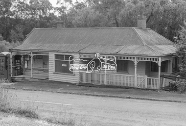
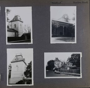
Album - Album page, Halstead, Bambra Road, Circa 1972
This photograph is part of the Caulfield Historical Album 1972. This album was created in approximately 1972 as part of a project by the Caulfield Historical Society to assist in identifying buildings worthy of preservation. The album is related to a Survey the Caulfield Historical Society developed in collaboration with the National Trust of Australia (Victoria) and Caulfield City Council to identify historic buildings within the City of Caulfield that warranted the protection of a National Trust Classification. Principal photographer thought to be Trevor Hart, member of Caulfield Historical Society. Most photographs were taken between 1966-1972 with a small number of photographs being older and from unknown sources. All photographs are black and white except where stated, with 386 photographs over 198 pages.From the Victorian Heritage Register Database - Citation for Halstead, 23 Bambra Road as at (as at 12/10/2020) https://vhd.heritagecouncil.vic.gov.au/places/276 Halstead is believed to be the oldest standing residence in Caulfield constructed in 1857 with subsequent additions during the 19th Century. The house was built for and owned by James Dickson, a stock agent, until his death in 1880. Although on a much reduced parcel of land, Halstead is one of the few remaining remnants of Caulfield when it was an area of mansion houses occupied by town residing squatters, professional and business men. It is important for its place in the socio-economic history of south eastern suburban Melbourne, the inland pattern of development stretching from Malvern through Murrumbeena. Architecturally the single storey building displays a history of alteration and addition. Its main front presents with a single storey cast iron verandah across the full width, including the two pavilion wings at each end. Located towards the rear on the Halstead Street side is the substantial three storey tower with its Mansard roof and cast-iron balustrade which makes the house clearly visible from Halstead Street and Bambra Road. Because of internal alteration the importance of the building relates to the exterior only of the main house. Halstead is believed to be the oldest standing residence in the city of Caulfield. https://vhd.heritagecouncil.vic.gov.au/places/43645 "Halstead" is regionally important as a surviving large villa from the early Victorian (1850's) period, offering insights into the lifestyles of the privileged in Caulfield at that time. The later tower is of architectural interest for its use of Medieval Romanesque enrichment.Page 32 of Photograph Album with four photographs of the exterior of this double storey house, focussing on different angles for the house's tower.Hand written: "Halstead" Bambra Road [top right] / 32 [bottom right] trevor hart, caulfield north, bambra road, 1850's, halstead, james dickson, mansion, villa residence, cast iron verandah, pavillion wings, halstead street, victorian, tower, balustrading, decorative brackets, mansard roof, brick, cast iron, slate roof, curved windows, single storey mansions, streetscapes, medieval romanesque style, slate roofs, gardens, cast iron work -
 Glen Eira Historical Society
Album - Album page, Halstead, Bambra Road, Circa 1972
This photograph is part of the Caulfield Historical Album 1972. This album was created in approximately 1972 as part of a project by the Caulfield Historical Society to assist in identifying buildings worthy of preservation. The album is related to a Survey the Caulfield Historical Society developed in collaboration with the National Trust of Australia (Victoria) and Caulfield City Council to identify historic buildings within the City of Caulfield that warranted the protection of a National Trust Classification. Principal photographer thought to be Trevor Hart, member of Caulfield Historical Society. Most photographs were taken between 1966-1972 with a small number of photographs being older and from unknown sources. All photographs are black and white except where stated, with 386 photographs over 198 pages.From the Victorian Heritage Register Database - Citation for Halstead, 23 Bambra Road as at (as at 12/10/2020) https://vhd.heritagecouncil.vic.gov.au/places/276: Halstead is believed to be the oldest standing residence in Caulfield constructed in 1857 with subsequent additions during the 19th Century. The house was built for and owned by James Dickson, a stock agent, until his death in 1880. Although on a much reduced parcel of land, Halstead is one of the few remaining remnants of Caulfield when it was an area of mansion houses occupied by town residing squatters, professional and business men. It is important for its place in the socio-economic history of south eastern suburban Melbourne, the inland pattern of development stretching from Malvern through Murrumbeena. Architecturally the single storey building displays a history of alteration and addition. Its main front presents with a single storey cast iron verandah across the full width, including the two pavilion wings at each end. Located towards the rear on the Halstead Street side is the substantial three storey tower with its Mansard roof and cast-iron balustrade which makes the house clearly visible from Halstead Street and Bambra Road. Because of internal alteration the importance of the building relates to the exterior only of the main house. Halstead is believed to be the oldest standing residence in the city of Caulfield. https://vhd.heritagecouncil.vic.gov.au/places/43645: "Halstead" is regionally important as a surviving large villa from the early Victorian (1850's) period, offering insights into the lifestyles of the privileged in Caulfield at that time. The later tower is of architectural interest for its use of Medieval Romanesque enrichment.Page 33 of Photograph Album with one landscape photograph of the exterior of Halstead, taken from the street.Hand written: 33 [bottom left] trevor hart, caulfield north, bambra road, 1850's, halstead, james dickson, mansion, villa residence, cast iron verandah, pavillion wings, halstead street, victorian, tower, balustrading, decorative brackets, mansard roof, brick, slate roof, curved windows, single storey mansions, cast iron work, medieval romanesque style, slate roofs, gardens -
 Flagstaff Hill Maritime Museum and Village
Document - Framed Poster, Borough of Warrnambool, Victoria, Australia, after 30/06/1875
This document, also referred to as a word picture or Tablet, is framed in glass and timber with gilt trim, is handwritten with colour highlights. The penned letters rest on ruled guide lines, decorated where the lines intersect. The writing gives a description of the state of Borough of Warrnambool around 1875; its location, the area it covers, its population, Harbour and facilities, public buildings and institutions, imports and exports, financial worth, number of houses, connection with other areas of the Colony. A possible reason and origin for the document is found in an article ‘Link with US Exhibition’ from the Warrnambool Standard of December 19, 1981, written by local historian Bruce Morris. The writer mentions that the Warrnambool Borough Council met on 15th June 1875 and recorded a letter from G.C. Levey , secretary to the Melbourne group of commissioners representing the Colony, and Victoria in particular, for the Philadelphia Centennial Exhibition of 1876. The letter asks Council to provide “statistics as to the population, social condition and commercial and industrial state of the district in and around Warrnambool.” A sub committee was formed for the project. The Mayor, Cr. Thomas King, wrote and signed a Report, presented to the council on July 14, 1875, in which “The Committee … begs to recommend that a Tablet be prepared setting for the particulars respecting the following matters relating to the Borough”. The matters included area, population, annual income, churches, schools, other public buildings, societies and companies, general description of houses erected, and returns of exports and imports for 1874. The minutes note that the Report was adopted. The article above also notes the opinion of Warrnambool printers who have examined the document; it is almost certainly to be an old lithograph, which means there could be several copies. It is possible that there may be a copy in Melbourne and another in Philadelphia. It is interesting to note that (1) the quoted location co-ordinates are for an “Unnamed Road, Packsaddle NSW 2880, Australia”, and that the DMS co-ordinates for Warrnambool’s Council Offices differ, being 38.23.9.12 South, 142.28.52.887. (2) the date for “Exports and Imports for the Year Ending 30th June 1875” is different to the period mentioned by Cr. King in the sub committee’s Report of recommendation “returns of exports and imports for 1874”. The information required to have the figures for the end of June 1875 would need to have been compiled very quickly for the Tablet to be ready for the opening of the Philadelphia Exhibition on 10 May 1876. The document/certificate shows the following – - - - - - - - - - - - - - - -- - - - - - - - - - - - - - -- - - - - - - - - - - - - - -- - - - - - - - - - - - - - - “Victoria Australia, Borough of Warrnambool. Latitude, 30.24.50 South, Longitude 142.32 East The Principal Port in the Western District of the Colony and the Centre of its Choicest Agricultural Lands. Established a Municipality in 1855, and Created a Borough 1863. Population in 1875 4,500. Warrnambool is the nearest Port to Melbourne on the Western Seaboard, being about 160 miles distant. Coaches run to and from the Metropolis daily, in connexion [connection] with the Railway of Geelong and Steamers belonging to Local Companies sail between Melbourne, Warrnambool, Belfast [renamed Port Fairy], and Portland several times weekly. The Harbour is known as Lady Bay, and is partially protected by a reef of rocks stretching from the mouth of the Hopkins River. The formation of a Breakwater has been decided upon by the Government, to extend 600 yards, at an estimated cost of £100,000. There are two substantial Jetties, one of 800 and the other of 600 feet in length. The former is connected with the Town by means of a Tramroad, along which Goods, inwards & outwards, are conveyed, & the latter has been constructed solely for the purpose of facilitating the transit of material for the formation of the Breakwater. In addition to the trade of the Borough and District, the principal Townships up country receive their supplies from Melbourne and ship their exports through Warrnambool. Potatoes form the staple produce of the district, and the richness of the soil can be estimated by the fact that the Government Statistics for 1875 give as the average yield a return of Seven Tons to the acre. Several thousand acres between Warrnambool and Tower Hill are now being laid down in Potatoes by Tenants who have leased the lands at rates up to £5 per acre for the season 1875-6. Wool, Tallow, hides &c are also largely exported, while the shipments of all descriptions of Farm Produce are annually increasing. Area of Borough, 3362 Acres. Net Annual Value £27,000. Annual Revenue £5,500. Number of Houses in Borough 800. Public Buildings and Institutions Churches. Church of England, Roman Catholic, Presbyterian, Wesleyan, Congregational and Baptist. Schools. Three State Schools, average attendance nearly 1000. New Building in course of erection. Several private establishments. Banks. Bank of Australasia, Bank of Victoria, National Bank, Colonial Bank and Savings Bank. Public Buildings. Court house, Custom house, Post & Telegraph Offices, Survey & Land Offices, Shire £, Town Hall, Mechanics Institute, Volunteer Orderly Room, Odd Fellows Hall, Hospital & Benevolent Asylum, Temperance Hall &c. Companies & Societies. Steam Navigation Co, Woolen Mill Co, Gas Co, Racing Club, Amateur Turf Club, Agricultural Society, Farmers’ Club, Cricket Club, Anglers’ Society, Building Society, Freemasons Odd Fellows, Foresters, Druids, Hibernians. Protestant Alliance, Rechabites, Sons of Temperance, &c, Fire Brigade &c. --- Exports and Imports for the Year Ending 30th June 1875 –-- --Exports Total Tonnage 27,800 (Calculated at the Current Warrnambool Market Prices) Potatoes Wool Wheat Barley Hides Skins Fowls Butter Cheese Eggs Tallow Leather Ale Pigs Sheep Sundries --Imports 13,000 Tons Of the Estimated Value of £520,000 Total Tonnage of Exports and Imports 40m900 Tons, Value £806,627 Passenger Travels, to ad from Warrnambool during year, 10,000 persons Revenue from all sources paid through Warrnambool Sub Treasury From 1860 to June 1875 £1, 292, 300 Thomas King [signed] Mayor Henry T Read [signed] Town Clerk” - - - - - - - - - - - - - - -- - - - - - - - - - - - - - -- - - - - - - - - - - - - - -- - - - - - - - - - - - - - - The document is of historical, social, economic and local significance in that it summarises activities, business, community, trade, travel and government at a point in time in Warrnambool’s history – 30th June 1875.Document, also referred to as a ‘word picture’ or ‘tablet’. Document is framed in glass and timber with gilt trim, handwritten with colour highlights. The penned letters rest on ruled guide lines, decorated where the lines intersect. Document outlines the establishment of Warrnambool as a Municipality in 1855 and Borough in 1863, with a population of 4,500 in 1875. It states geographic location, public buildings and institutions, harbor facilities and imports and exports for the year ending 30th June 1875. Two signatures "Thomas King" Mayor and "Henry T Read" Town Clerk. It shows the Coat of Arms of the Borough of Warrnambool.Signatures - "Thomas King" Mayor and "Henry T Read" Town Clerk. Warrnambool Coat of Arms; “British Coat of Arms, above sailing vessel and sheaf of wheat in sun, motto “By these we flourish” and around circumference “Borough of Warrnambool 1855”flagstaff hill, warrnambool, shipwrecked coast, flagstaff hill maritime museum, maritime museum, shipwreck coast, flagstaff hill maritime village, great ocean road, borough of warrnambool, municipality of warrnambool, document borough of warrnambool 1875, word picture of warrnambool 1875, tablet of borough of warrnambool 1875, statistics borough of warrnambool 1875, lithograph borough of warrnambool 1875, coat of arms warrnambool, warrnambool city motto – in these we flourish, establishment of warrnambool, warrnambool history, thomas king mayor of warrnambool, henry t read town clerk of warrnambool, warrnambool breakwater, warrnambool jetty, warrnambool imports and exports 1875, warrnambool agriculture 1875, warrnambool business 1875, warrnambool population 1875, centennial exhibition philadelphia 1876, framed certificate -
Federation University Historical Collection
Book, Hepburn Shire Council - Hepburn Shire - Tourism Directions Statement 2002, 2002
Hepburn Shire Council - Hepburn Shire - Tourism Directions Statement 2002White bound book of 31 pages.hepburn, sustainable tourism management, major themes, future directions, community, environment, customers, council, organisational roles, recommended structure - sustainable economic development advisory group, sustainable tourism focus group, hepburn shire council