Showing 857 items matching "surveyor"
-
 University of Melbourne, Burnley Campus Archives
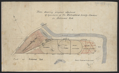
Plan, John S. Jenkins, Plan showing proposed adjustment of boundaries of the Horticultural Society's Gardens in Richmond Park, c.1880-1884
Plan on linen fibre cloth. Shows layout of Burnley bound by Swan St., Yarra River and part of Richmond Park, coloured areas showing proposed area to be added to Park, the old road, shrubbery, new hall, old garden, recent extension and proposed further extension (crossed out in red ink). Scale 4 chains:1 inch. Probably drawn by John S. Jenkins, Town Surveyor, Richmond. Has been photographed so that additional copies can be made. On a CD plus 3 negatives, plus small coloured print. (Also copy glazed and framed for Centenary Exhibition - B92.0540.)john s. jenkins, gardens, richmond, hoticultural society of victoria -
 Bendigo Historical Society Inc.
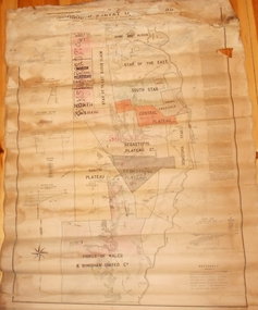
Map - MARKS COLLECTION: MAP MINES BALLARAT AREA 1887
Large buff coloured map, wooden strip on bottom, top hanger missing, showing mine boundaries in Ballarat mining area. Mines include from top of map Bonshaw No. 1; Band and Albion Consolidated Company; Central Bonshaw; North Bonshaw; Star of the East block Claim; Star of the East; South Star; Owen's Freehold; Central Plateau; Sebastopol Plateau Company; Sebastopol Star; Sebastopol Plateau No. 1; South Plateau; Prince of Wales; Bonshaw United company; Gay's Freehold. Map prepared by Robert Alan, under the direction C.W. Langtree, Secretary for Mines, and Chief Mining Surveyor.map, ballarat, ballarat, mining, goldmining -
 Bendigo Historical Society Inc.
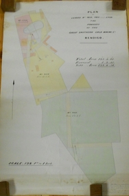
Plan - MARKS COLLECTION: LEASE PLANS GREAT SOUTHERN GOLD MINE BENDIGO
Plan on heavy paper, tightly rolled. On top of plan "Plan of Leases 5429, 4810, 4811 and 5429", The Property of the Great Southern Gold Mining Co. Bendigo' \Total area123 acres, 3 roods, 33 perches, excised, nett area 122, 0. 38. On bottom '32 feet to one inch' and 'This plan was devised from Government Mining Lease Plans and from actual survey' Signed E.F Brown, certificated mining and authorised surveyor 25/6/87' Leases No. 5429 and 4810 details location of shaft, tramway, battery, engine house and boiler. Large mining dam outlined.bendigo, mining, great southern gold mine -
 Kiewa Valley Historical Society
Tool Spring Set, circa early 1900s
This is part of a crosscut saw raker/jointer/guage set used to bend the tip of each cutter tooth for cross cut logging saws. The logging saws used in the early 1900's for the clearing of forests required constant sharpening of their "cutting teeth". The logging of forested areas during these times was very much a "hands on" method of either one or two men by the use of saw or hand axe. This item was used by the surveyors commissioned by The S.E.C. Victoria Kiewa Hydro Electricity Scheme project mapping the relevant Alpine region. Chain saws, chain and ball(clearing) and bulldozing methods came in the mid 1900's.This particular saw sharpening method was used by surveyors laying down boundaries for the S.E.C. Victoria Hydro Electricity Scheme (1920's). This item was given to a local Kiewa Valley lad who accompanied the initial surveyors. The lad was responsible for the tendering and feeding of the surveyors "pack horses". Surveys work during this period and in these dense mountainous terrain of the Victorian Alps was both exhausting and hazardous. Overnight accommodation at various log cabins was not always possible and swag/tent alternative was the "fall back".This cast iron Spring Setting tool has a main body of angle iron contours with one end tappered into a flat circular extension with a slit (3/32" wide) running from the top to nearly the centre(15mm). This slit is to allow the bending of each "cutter tooth" of the cross cut saw. The "bottom of this slit has a semi circular ending. Protruding from one side of the bar body, and close to the "slit" is a tounge like extension (wedge) to fasten the spring set tool into a tree stump. See KVHS 0090 (A) for its Raker/Jointer saw sharpening guage set partner. Also see KVHS 0090 (C) for the associated wrench. On one side of the bar "DISSTON U.S.A."hand tool, saw, sharpening method, tree felling -
 Federation University Historical Collection
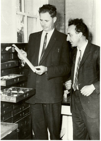
Photograph, Jack Barker and Phil Day with the Baragwanath Donation
William Baragwanath joined the Victorian Department of Mines in 1897, was director of the geological survey (1922-4), Chief Mining Surveyor (1924-43), Secretary for Mines (1932-34), consultant to the Department of Mines (1943-50) . He was born at Durham Lead on 1 August 1878 and was a former student of the Ballarat School of Mines. Baragwanath was president of the Royal society of Victoria (1943-44) and a councillor of the Ballarat School of Mines (1916-1950). After Baragwanath's death on 20 September 1966 the Department of Minerals and Energy (Geological Survey division) donated a number of Baragwanath's items to the Ballarat School of Mines, including this collection. Black and white photograph of E.J. Jack Barker (Ballarat School of Mines Principal) and Phil Day (Head of Geology) standing in front of a cabinet of geological specimens housed in a timber cabinet. ballarat school of mines, geology, ej barker, jack barker, phil day, baragwanath, william baragwanath, victorian mines department -
 Queenscliffe Maritime Museum
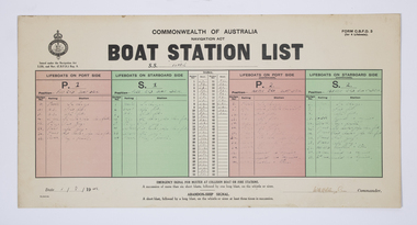
Document - Form, Boat Station List
The Court of Marine Inquiry found that the steering gear had failed as the SS Time entered Port Phillip Heads. It was established that the fault lay with the Lloyd's surveyor for not detecting the fault when the Time had been classified Al. No blame was attached to the master. Two Queenscliff fishermen purchased weck for 950 pounds (insured value 30,000 pounds)and its timber cargo - handsome profit. Cargo and most fittings of value recovered. Wreck visible until early 1960s, until during a storm it slid off northern side of Nepean reef and broke up in 20 feet of water. The most noteworthy shipwreck to date at the heads.Two Queenscliff fishermen purchased the weck for 950 pounds (insured value 30,000 pounds) and its timber cargo - handsome profit. The cargo and most of the fittings of value were recovered. The wreck was visible until the early 1960s, until during a storm, it slid off the northern side of Nepean Reef and broke up in 20 feet of water. The most noteworthy shipwreck to date at the heads.A Commonwealth of Australia Navigation Act, Boat Station List form, showing the names of crew assigned to each of 4 lifeboats on the Port [P] and Starboard [S] sides of the SS Time dated 1 August 1949.Form C.B.D.F 3 for 4 lifeboats; Boat Station List navigation act, ss time, port phillip, shipwrecks, lifeboat rules -
 Kew Historical Society Inc
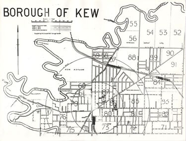
Plan, Borough of Kew, 1910
This work forms part of the collection assembled by the historian Dorothy Rogers, that was donated to the Kew Historical Society by her son John Rogers in 2015. The manuscripts, photographs, maps, and documents were sourced by her from both family and local collections or produced as references for her print publications. Many were directly used by Rogers in writing ‘Lovely Old Homes of Kew’ (1961) and 'A History of Kew' (1973), or the numerous articles on local history that she produced for suburban newspapers. Most of the photographs in the collection include detailed annotations in her hand. The overhead transparency is of a map produced by H.C. Crouch Borough Surveyor in 1910The Rogers Collection provides a comprehensive insight into the working habits of a historian in the 1960s and 1970s. Together it forms the largest privately-donated collection within the archives of the Kew Historical Society.An overhead transparency of a plan of Kew comparing the roads in 1860 with later roads constructed by 1910. Sections of the plan are marked with the location of particular buildings, farms or transport routes.Borough of Kewborough of kew, h.c. crouch -
 Glen Eira City Council History and Heritage Collection
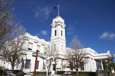
Photograph - Building, Glen Eira Town Hall, 1884
Originally known as Caulfield Shire Hall, the original 1884 building was designed by Shire surveyor Sydney Smith. In 1931 the Caulfield Town Hall, as it was then known, was remodelled to include the main hall and foyer and a Neo-Grecian portico with Corinthian Order columns. Major works completed since 1945 include Caulfield Arts Complex (opened 20 August 1988), Caulfield Library (opened 4 December 1993) and the award-winning Caulfield Municipal Offices extension which opened on 24 February 1991. The building is listed as No. H0106 in the GECC Heritage Overlay Schedule. The site also includes a Significant Tree (H&H Register No. 034). Brick exterior of two storey building painted white and featuring pillared portico entrance and solid glass doors on Glen Eira road facing north. On the eastern side of the portico is a two storey clock tower with clock surmounted by a flagpole and flag. Some of the eastern section of the building is original with various alterations over the years. The award winning service centre and offices in the westerly aspect of the town hall were extended on to the original buliding in 2000.building, town hall, council, local government, caulfield, glen eira, moorabbin, sydney smith -
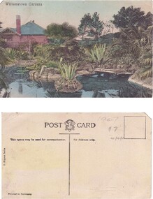 Williamstown Botanic Gardens- Hobsons Bay City Council
Postcard – Williamstown Botanic Gardens, M Schulz, Prague, c1900-1920
The original postcards in this series (2013.002 to 2013.018) were generously loaned to Williamstown Botanic Gardens by a private collector for copying. The Curator’s lodge, designed by the Town Surveyor, HV Champion, was constructed in 1907 following the re-organisation of the north-east corner with the demolition of the old curator's cottage and erection of new gates. Both the lodge and lake (1904) were built during the curatorship of Mr Thake. The logo in the middle of the words ‘POST CARD’ indicates the card was printed by M. Schulz in Prague. Schulz was a long-established company from Prague and printed postcards for customers from worldwide. Schulz printed in photo-chromolithography. The postcards are evidence of the interest the gardens held as a subject for postcard publishers. The text and images provide a snapshot into fashions, social interests and concerns of the time. The professionally produced images provide a pictorial history of Gardens including changing planting styles, various structures and features of the Gardens eg the aviary, cannons, the fountain, the second Curator’s Lodge and gates. The images offer an opportunity to compare garden vistas with the present day.A colour image of the ornamental lake and part of the Curator’s Lodge. The lodge has a green roof, tall brick chimney, is brown timber with brick where the fireplace would be. The small island with a succulent is in the centre of the image. The image looks across the top of the lake where the rock edging can be seen. Reflections of the plantings and lodge can be seen.Front: ‘Williamstown Gardens’. Reverse: Reverse: Centre top ‘POST CARD’ with a logo [MS] in the middle of the words; left side vertical ‘O. Rippon Series’; left side ‘This space may be used for communication.’; right side ‘For Address only.’; left side bottom ‘Printed in Germany’. In pencil top right corner ‘1907 / $7’ (believed to be inserted by the vendor.postcard, gardens, post-card, williamstown-botanic-gardens, hobsons-bay-city-council, curator’s lodge, ornamental lake, succulents, 1907 -
 Melbourne Legacy
Document, Legatee Frank Doolan notes on the Shrine of Remembrance
Handwritten notes signed by Frank Doolan in response to an unnamed article on the building of the Shrine of Remembrance. A first page of notes is missing, indicated by the notes being numbered 5-14. Note No. 10 refers to the founding of Melbourne Legacy being erroneously attributed to Sir John Gellibrand. The pages are undated but refute in detail many of claims made by the 'architect author'. Doolan clearly feels passionate about the Shrine and Legacy's links to it and has very detailed knowledge about the building as he was a surveyor who worked on the building. An item from Legatee Frank Doolan, who was on the archive committee and made attempts to collate the history of Legacy. Illustrates the activities of Melbourne Legacy in the wider community, particularly in relation to the Shrine of Remembrance.3 handwritten sheets, blue/black ink on white lined note paper.history, shrine of remembrance -
 City of Kingston
Map - Parish of Moorabbin
Warning: This object includes historical language referring to First Nations Peoples which is no longer appropriate but has been recorded for historical purposes. Produced in 1853, this map shows the land holdings of European families. While the majority of holdings are small there are also large land holdings as can be seen with Henry Dendy's Special Survey. Of particular note is the "Reserve for Aborigines" which was established in approximately 1841 and consisted of over 830 acres. This area is the current location of Mordialloc township and Attenborough Park, in Mordialloc, is the last remnant of the reserve. An Alfred Sikes, possibly the surveyor/cartographer who drew this parish plan, purchased land in Berwick in 1854.A handrawn map on fabric, with blue markings representing the coastline to Port Phillip Bay, red markings representing a proposed train line to Mordialloc, major roads and street, as well as a "Reserve for Aborigines", which constituted approximately 830 acres. In the bottom right hand corner, the map has been signed and dated.Handwritten in ink: Alfred Sikes / 38 Collins St East / June. 1853moorabbin, mordialloc, dendy, port phillip bay, aboriginal reserve, attenborough park -
 Mt Dandenong & District Historical Society Inc.
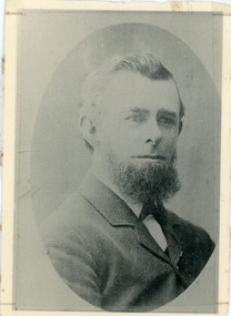
Photograph, Thomas Hand 1839-1888
Copy of a formal photograph showing head and shoulders of Thomas Hand, 1839-1888. This photograph has a detailed inscription on the back handwritten by John Lundy-Clarke in 1974.Thomas Hand 1839-1888 Surveyor for Upper Yarra Road Board 1862-1872. Engineer for Shire of Lillydale 1872-1888. Father of Kate, Eva, Eliza, Florence, Mabel, Alice, Frederick and William. Married Eliza Erith 1862. Owner of “Mountain Grange” in the present district of Kalorama. Copy of photograph in possession of his daughter Mabel made by JLC in 1974. thomas hand, mountain grange -
 Ringwood and District Historical Society
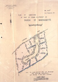
Document - Folder, Pembroke Estate Subdivsion, Ringwood, Victoria - 1964
Manilla folder containing certified copy of Plan of Subdivision dated 2nd September, 1964 - Part of Crown Allotment 29 Parish of Warrandyte, and separate A4 size copy of plan with handwritten 1966 pricing notations. Subdivision includes allotments on Pembroke Court off Loughnans Road, Ringwood.Surveyors - Kirkpatrick & Webber, Civil Engineers & Town Planners, 225 Maroondah Highway, Ringwood, Telephone 8700321. Agents - C.E. Carter & Son RESI., 126 Whitehorse Road, Ringwood (Phone) 87-6024, 87-6830, 870-2519. Folder covernote by Richard Carter - Carter Real Estate - "Vendor - Dale, Plan of Subdivision 68868, sold 23 July 1966." -
 Ringwood and District Historical Society
Map - Plans of Subdivision, Part of Crown Allotments 35 & 39, Parish of Warrandyte
Survey maps of stages 1, 2 & 3 of residential allotments in Kalinda Road and Grayling Crescent, Ringwood, Victoria. (Undated, circa 1960). Some allotments are marked with real estate information and prices in pre decimal £s.Adshead & McGuire, Land Surveyors L.S. M.I.S. (Aust), 268 Albert Street East Melbourne (Ref 118/2a b &c) Tel 41-6960. The land colored blue is set apart for drainage & sewerage purposes. Reference Marks (R.M's) are Gal Iron Pipes 12"x1". Levels shown are to M.M.B.W. Datum. The land shown hatched is subject to innundation. -
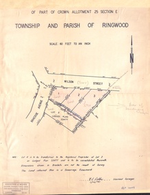 Ringwood and District Historical Society
Document - Plan of Subdivision, Part of Crown Allotment 25 Section E, Township and Parish of Ringwood - 1961
Map showing residential allotments numbered 1, 2, 3 and 4, on Wilson Street and Braeside Avenue, Ringwood East, Victoria.Signed and dated 1/12/1961. Rubber stamped Kirkpatrick & Webber, Licensed Surveyors, Civil Engineers & Town Planners, 225 Maroondah Highway, Ringwood, Telephone 870-0321. Ref 3438C. "Note: Lot 4 is to be transferred to the Registered Proprietor of Lot 2 on Lodged Plan 23477 and is to be consolidated therewith." Map also includes handwritten Estate Agent notations. -
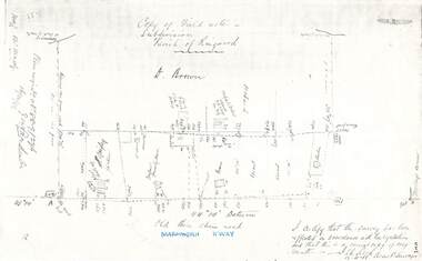 Ringwood and District Historical Society
Document - Copy of Lands Department Field Notes - Parish of Ringwood, Victoria, Field Notes 88-9/276 - Part of O.P. R72C surveyed 12.10.1888
Foolscap size photocopy of survey map with handwritten notations. References include - Commencing at bank of creek, Bearing over fence read 134"12', post and rail fence, old round post, Quigley, WB house iron roof, paling & shingle roof, garden, Forshaw formerly Hoare, D Brown, stable & shed, slats & palings, orchard, Occupied by Forshaw, 4 rooms WB Cottage iron roof, Sherbin, Old three chain road, Maroondah Highway, Molloy's corner, I certify that this survey has been effected in accordance with the regulations and that this is a correct copy of my results (signed) - Reed, Assistant Surveyor, 12.10.88. -
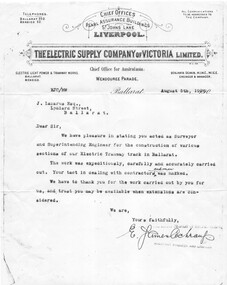 Ballarat Tramway Museum
Document - Photocopy, Brian Robertson, ESCo letterhead to Mr. J. Lazarus Esq, Aug. 1993
Photocopy of a letter dated August 5, 1908, typed on ESCo letterhead to Mr. J. Lazarus Esq advising that he capably acted as Surveyor and Superintending Engineer for the construction of various sections of tramway track in Ballarat and thanking home for his work. Signed by E. James Beauchamp, Assistant Engineer and Manager. Accompanying the photocopy is a photocopy of a letter dated 17/3/1993 from Brian Robertson of 20 Main St Welshpool. Items from Mr. Lazarus had been left to him. Comments that Mr. Lazarus was a well known engineer in Ballarat prior to the first world war. Images added 27-11-2016.trams, tramways, esco, trackwork, construction, engineers -
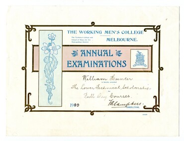 Orbost & District Historical Society
certificates, 1909, 1911, 1912
These four certificates belonged to William Hunter. William Hunter (1893-1971) was a resident of Tatura and Mallacoota. He was a soldier, surveyor and amateur naturalist. The certificates include two first prizes for surveying, a technical scholarship for full day courses and a certificate for Applied Mechanics. William received his Surveying Certificate in April 1916. In June 1887, the Working Men's College opened after Francis Ormond, a noted Victorian philanthropist and member of parliament, suggested that a technical institute be built in Melbourne, offering further education for working men and women. He had offered to match the sum raised through public subscription if the government could provide a site for the College. William Hunter made valuable contributions to our knowledge of far East Gippsland plants. His records were meticulous. These certificates are part of his history.Four card certificates of merit for "Annual Examinations" from the Working Men's College, The Technical College and School of Mines for the Metropolitan District.All four certificates awarded to "William Hunter" and signed by Mordaunt Arundel Hall (accountant & chief clerk WMC) as the Acting Director.hunter-william-surveyor -
 Warrnambool and District Historical Society Inc.
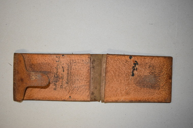
Artefact, Field Wallet, Early 20th century
This is a field wallet that belonged to Rolf Crawley. He was an engineer, surveyor and architect in private practice in Warrnambool and also the engineer for the Shire of Warrnambool from 1935 to 1968. His grandfather, father and uncle were also engineers, working in that capacity or as the Shire Secretary for the Shire of Warrnambool, with the Crawley family recording a total of 132 years service to the Shire. The Shire of Warrnambool existed from 1863 to 1994. The wallet came into the possession of Michael Hand who took over the private surveying business of Rolf Crawley in Warrnambool. The Warrnambool and District Historical Society acquired the wallet, along with several ledgers and other Crawley memorabilia from the estate of Michael Hand. This wallet is of interest as it was owned and used by Rolf Crawley when he was doing field work in connection with his surveying and engineering jobs either in private practice or as the Shire of Warrnambool engineer in the 20th century. This is a brown leather wallet in two sections that fold over and close with a flap or tongue that inserts into a strip of leather stitched into the cover. The two sections have extra pieces of leather that are stitched on to make compartments. These contain three pieces of thick card folded over. These cards have rough notes and figures handwritten on them. Inside the wallet is a hand-printed name. The wallet is much scuffed and stained. ‘Rolf L. Crawley L. S. Shire Hall Warrnambool’rolf crawley, warrnambool, shire of warrnambool -
 City of Greater Bendigo - Civic Collection
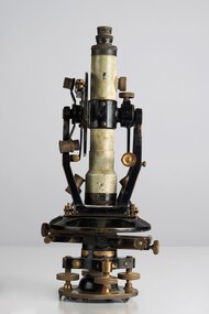
Instrument - Theodolite, E. R. Watts & Sons, c 1930
Theodolites are a highly accurate instrument that measures angles between designated visible points in the horizontal and vertical planes. The theodolite has a long history, with the term first found in 1571 in a surveying textbook 'A geometric practice named Pantometria' by Leonard Digges. (source https://en.wikipedia.org/wiki/Theodolite). Theodolites are used by surveyors as part of their everyday work and although there is no specific information regarding the provenance of this particular one it is assumed it was used locally by the Shire of Marong and / or the Lands Department. Edwin Watts started the company in 1856, trading up to 1920s as E.R. Watts & Son with E. R. Watts & Son Ltd amalgamating with Adam Hilger Ltd to form Hilger & Watts in 1948.0442.1 A black and grey theodolite no 39161 made by Watts & Sons. Various moving parts showing signs of extensive use particularly on the uprights on the main body and around knobs and dials where the paint is worn back to brass. Is housed in original box with key, oil container and pin. 0442.2 handwritten instructions for making adjustments to the Theodolite written on the back of Road Users' Association of Victoria letterhead note paper.Watts & Sons / London / 5974 For N H Seward / Melbournelands and survey department bendigo, shire of marong -
 Bendigo Military Museum
Instrument - Heliograph Mk V Training Aid - circa 1912, 1912
The Heliograph MkV is a fascinating piece of historical surveying and communications equipment. It was primarily used for visual signaling by reflecting sunlight with a mirror to send coded messages over long distances. This method was primarily useful in remote areas where other forms of communication were not available. The MkV model, specifically, was widely used by the British Army and other military forces from around 1906 until the mid 1960s. It remained in use with the Australian Army Survey Corps until the mid 1980s. The device typically included a 5 - inch mirror and was often mounted on a tripod for stability. Initially the instrument was used to communicate between survey stations using Morse code to coordinate their activities. Later when better forms of communication were available they were used for precise angle alignment where the sunlight reflection from the mirror was targeted between the survey stations to give very accurate results. The MkV was relatively light weight and portable, making it ideal for use in the field. It could be setup and adjusted quickly. The heliograph had an adjustable mirror that could be tilted to reflect sunlight towards a distant receiver. Surveyors could align the mirror using a sighting device. Whilst it was primarily used by the Military it was also used in civil surveying particularly in the remote areas of Australia. This instrument was used as a training aid to help teach surveyors at the Royal Australian Survey Corps School of Military Survey. Catalog item No 2009 is a tripod that was used to mount the Heliograph whilst being used for surveying.A Heliograph containing two mirrors with brass surrounds mounted on a wooden board as a Training Aid. Item has additional parts attached to the base board."Heliograph Mk V Training Aid"royal australian survey corps, rasvy, fortuna, army survey regiment, army svy regt, asr -
 Bayside Gallery - Bayside City Council Art & Heritage Collection
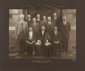
Photograph - gelatin silver photograph, Sarony & Co, The Councillors and Officers of the first City of Sandringham Council, 1923
This photograph records the Councillors and officers on the day that the Town of Sandringham became a City, and the first meeting of the City of Sandringham Council was held. Sandringham was originally part of the Shire of Moorabbin. On 28 February 1917, Sandringham was severed from Moorabbin and incorporated as the Borough of Sandringham. It was proclaimed a Town on 9 April 1919 and a City on 21 March 1923. city of sandringham, councillors, local government, municipality, mayor, cr. h.b. grace, cr. w.h. kay, cr. j.m. ramsay, cr. f.n. gibbs, cr. g.w. knott, cr. r. chisholm, t.g. farrant, cr. c.a. hartsmann, m.h.t. williams, town clerk, cr. j.t.d. beck, m.w.t. sanderland, surveyor -
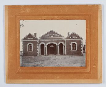 City of Greater Bendigo - Civic Collection
Photograph - Strathfieldsaye Shire Hall
The district of Strathfieldsaye was proclaimed in 1861 and named a Shire on the 17th September in 1866. It remained a shire until amalgamation in 1994 when it became part of the City of Greater Bendigo. The shire was located 8 km to the south- east of Bendigo and covered an area of 601 square kilometres and extended from the Calder Highway to the Coliban and Campaspe Rivers. The shire's administration activities were centred at the Strathfieldsaye Shire Hall which was built in 1869 at a cost of £700 based on a design by George Steane, the shire surveyor and built by George Pallett of Sandhurst. Constructed of red brick, the hall has a unique ventilation system with hollow walls open at the top and bottom to ensure a draught to cool the building in summer. Framed and mounted photograph of the Strathfieldsaye Shire Hall. Verso; W M Robinson / Photographer / Mundy Street Bendigostrathfieldsaye shire hall, shire of strathfieldsaye, strathfieldsaye shire council -
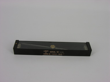 Frankston RSL Sub Branch
Compass, Plane Table, J. W. Handley, 1943
A plane table compass, sometimes referred to as a trough compass, used by surveyors and artillery crew to accurately establish magnetic north. The compass is precision machined of brass material with a long needle to ensure accuracy. The compass scale is marked with a centre zero (for magnetic north) and graduations indicating plus and minus five degrees. The compass is housed in a protective wooden case with a sliding lid. The lid has a brass slide which locks the compass needle during periods when the compass is not in use. This compass is the type used by an artillery unit of the Australian Military Forces during World War 2. This compass was manufactured by J. W. Handley P/L of Melbourne in 1943. Refer 00330 and 00330.2The side of the compass body is stamped: "J.W.H." with the letter "V" under a line, "SERIAL No 1082", MARK.II-D^D-1943". The case is stamped with the serial number "1082".artillery, trough compass, plane table compass, compass, world war 2, ww2 -
 Bendigo Historical Society Inc.
Document - CONTRACT OF SALE - 11 JUNE 1895 - WILLIAM HENRY CUNDY TO ARTHUR ALLSOP AND MICHAEL KELLY
Contract of sale - 11 June 1895 - William Henry CUNDY to Arthur Allsop and Michael Kelly. Contract of sale and contract of 'Hiring and Letting' between William Henry Cundy of Barkly Place, Bendigo , Surveyor and Arthur Allsop and Michael Kelly, Financiers of Wills St, Bendigo Document witnessed by John F Gleeson, Managing Clerk to Crabbe, Cohen, Kirby, Solicitors, Bendigo The document consists of four pages and a memorandum of agreement between WH CUNDY and Arthur ALLSOP and Michael KELLY for the purchase and re-hire of a building and it's contents. There is a detailed list of contents for each of the rooms in the house. This number also includes a research sheet re the death of Mr. Charles Cohen, Solicitor.bendigo, history, housing/cultural, william henry cundy, arthur allsop, michael kelly, crabbe, cohen, kirby, john f gleeson, barkly place, wills st, milroy st. -
 Kew Historical Society Inc
Plan - Subdivision Plan, H C Crouch, Old Golf Links Estate, 1930s
The land in North Kew between the Outer Circle Railway and the River Yarra was released in sections. This release included 80 lots. Most of this area was released during the Depression years in the early 1930s.Subdivision plans are historically important documents used as evidence of the growth of suburbs in Australia. They frequently provide information about when the land was sold on which a built structure was subsequently constructed as well as evidence relating to surveyors and real estate and financial agents. The numerous subdivision plans in the Kew Historical Society's collection represent working documents, ranging from the initial sketches made in planning a subdivision to printed plans on which auctioneers or agents listed the prices for which individual lots were sold. In a number of cases, the reverse of a subdivision plan in the collection includes a photograph of a house that was also for sale by the agent. These photographs provide significant heritage information relating house design and decoration, fencing and household gardens.One part of a massive subdivision of the Old Golf Links Estate in North Kew of 80 allotments bordering Sutherland Avenue, Ramsay Avenue, Belford Road, Beresford Street and Coleman Avenue. Inset on the plan at the top left, the route of the Outer Circle Railway is clearly marked. The Kew Golf Links is identified in its current location. The land on which Greenacres Golf Club was to be constructed is at this time marked as ‘Recreation Ground’. The ‘new bridge’ over the Yarra at Burke Road is also marked on the inset map. The Plan identifies the surveyor (sic) H.C. Crouch BCE MVIS, 443 Little Collins St., Melbourne. The date of the subdivision auction sale in identified as Saturday September 25th at three o'clock.Annotations: "E" top left. "Golf Links" top right. Lots 73-76 ticked and listed as "6" poundssubdivisions -- kew (vic.), old golf links estate -
 Kew Historical Society Inc
Archive (Sub-series) - Subject File, Kew Historical Society, GRIMES, Charles, 1962
Various partiesReference, Research, InformationSecondary Values (KHS Imposed Order)Charles Grimes was acting Surveyor-General of the Colony of New South Wales. He was the first European cartographer to map the lower reaches of the Yarra River. The reference file contains both research on the ‘exploration’ by Grimes as well as information on a re-enactment, sponsored by the Kew Historical Society in 1978, to mark the 175th year of his party’s arrival in the area of what is now Dight’s Falls. In the file is a 13-page handwritten document to be used as a script for a speech during the reenactment, which also includes details of the costumes to be worn. There are additional unpublished manuscripts in the file about Grimes and his ‘journey’ by Mr Chinner and Mavis Rolley. The file also includes newspaper articles/clippings as well as sundry published articles.charles grimes, commemorations - kew (vic.), european exploration - kew (vic), yarra river - historycharles grimes, commemorations - kew (vic.), european exploration - kew (vic), yarra river - history -
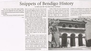 Bendigo Historical Society Inc.
Newspaper - JENNY FOLEY COLLECTION: SNIPPETS OF BENDIGO HISTORY
BHS CollectionBendigo Weekly date unknown. '' Snippets of Bendigo history'' by Edith Lunn the View Street story continued. In this article Edith Lunn describes Dudley House, originally the survey office and the oldest permanent government building in Bendigo. From 1854 surveyor Richard Larritt worked there. It was in 1890 that the name Dudley house was attached to the building. Town clerks W. Honeybone and H.C. Inleton lived there. Later it was the home of Dr. Peter Slater, after he moved out city engineer Mr. Rex Anderson moved in. After his death the Bendigo branch of the Royal Historical Society of Victoria established its home there after 25 years Dudley House reverted to the Council. The clip is in a folder.newspaper, bendigo, bendigo weekly -
 Melbourne Legacy
Document - Eulogy, Legatee Francis John Doolan
Information on the life of Legatee Frank Doolan from a eulogy in 1988. Legatee Doolan was a very active Legatee, starting within the first year of Legacy when he was nominated by Bill Laver and Charles Copp in 1924. While he never sought 'office but he was always there - in the background - able and willing to actively serve'. In World War 1 he enlisted in November 1917 and served with 1st Division Signal Company and in France. After Armistice he attended a course for young AIF surveyors at the British Ordnance Headquarters at South Hampton designed to bring skills back to Australia. Famously it was Frank that proposed that the spirit of Legacy is service to the widows and children. "Here it received its soul. The thoughts transmitted to the Board by this quiet man." He was Legacy's link to the Big Brother movement that was sponsoring bereft children in England to be sympathetically housed in Australia. He was a foundation member of the the first boys' gymnasium class and of the literary and debating class. He worked with the Intermediate Legacy Club for it's entirety He was part of the Legacy team who worked enthusiastically for the establishment of the Shrine. It was his technical skill as a surveyor that enabled the ray of light to shine on the Stone of Remembrance at 11 am on 11th November. Also to solve the complication of daylight saving in 1976 by positioning two mirrors. For this he was awarded the British Empire Medal. Born in 1896 at Armadale he was educated in Ballarat and South Melbourne. He obtained his qualification as a licensed surveyor at the Working Men's College (now RMIT) in 1919 on returning from war. He was partner in 'Doolan and Goodchild' through the hardships of the Great Depression. Then joined firm of Mendell, Gillespie and Charleman - being supported by Legatee Jim Gillespie. He went on to Lecturer of surveying at the Working Men's College from 1926 to 1938. Then he was assisted by Legatee Alan Murray to a position with the Valuers Section of the Department of Interior. In 1953 he was promoted to be Chief Property Officer for Victoria retiring in 1961. The page from the Bulletin from 18 August 1988 shows the names of many donors that had paid tribute to Frank. A few sentiments were included by some: 'A quiet, loveable and outstanding Legatee.' 'He was my friend, guide and mentor during the 14 happy years I spent in Legacy.' The information was part of an album of past presidents from 1965 to 1989. The folder included biographical details and obituaries, eulogies and death notices of prominent Legatees. The items have been catalogued separately.Part of the collection of material held by Melbourne Legacy on Legatee Frank Doolan a prominent member of Legacy. The information was collected to record the lives of prominent legatees in a folder.Typed A4 document x 2 pages of the life of Legatee Frank Doolan and one page from the Bulletin with donations received in his memory.eulogy, frank doolan, ray of light, shrine of remembrance, ilc, donations -
 Warrnambool and District Historical Society Inc.
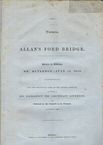
Document, Allan’s Ford Bridge 1852, 1852
This is an original Victorian Government document containing the printed version of 37 reports and letters regarding the building of the first Allansford bridge completed early in 1852. The correspondence dates from October 1850 to February 1852 and includes letters and reports from Melbourne Government employees such as Robert Hoddle, Chief Surveyor, David Lennox, Superintendent of Bridges and Lieutenant – Governor Charles La Trobe. The correspondence from local settlers included the names of William and John Allan, John Davidson and James Coulstock. The correspondence shows that some settlers in the Warrnambool/Port Fairy district wanted a portion of the Government allocated funds spent on the local roads and bridges in other locations. The 1852 Allansford bridge cost £480 and was replaced in 1870. This document has strong historical significance as it relates to one of the earliest State government works in the district and records the public imput into the decision.. It contains opinions and correspondence between a number of early settlers in the district at the time.Grey/blue paper document with black text. 21 pages plus 4 page index at back.allan's ford 1852, allansford bridge, allansford, history of allansford, warrnambool