Showing 969 items
matching homesteads
-
 Mt Dandenong & District Historical Society Inc.
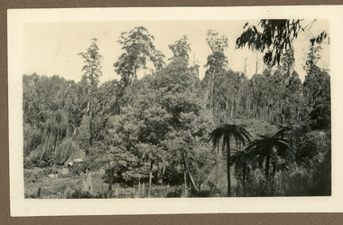
Photograph
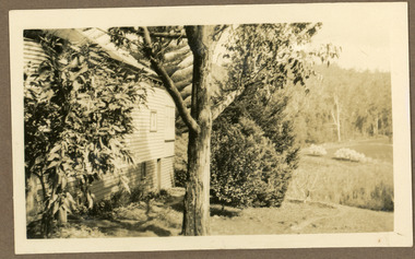
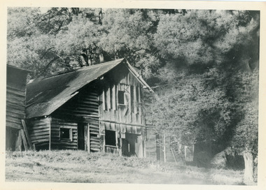
The photograph is from the album of Ivy May Child and the roof visible may be that of the Child Family Homestead. Ivy May Child (1910 – 1989) was the daughter of Arthur Edward (Ted) Child (1878 – 1964) and Ethel May Madden (1888 – 1970). Ted Child was the son of Matthew Francis Child (1839 – 1933) and Martha Jeeves (1857 – 1926). He was the grandson of one of the early pioneers Francis Child. Ivy grew up on the family property on Childs Road and took many photographs. Most of these are glued into her photo album. The album covered the years from c1927 – 1932. Ivy married Henry William Burgess (1906 – 1968) in 1944. The photographs remain in their original state in the album with individual copies made. Black and white photograph of a bush setting. Tree ferns are in the foreground and general bush trees beyond. The roof of a house is visible to the left.bush, tree ferns, child family, ivy child -
 Mt Dandenong & District Historical Society Inc.
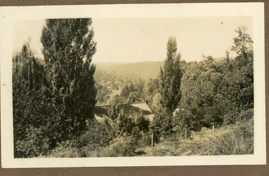
Photograph
The photograph is from the album of Ivy Child and shows the homestead of her parents Ted and Ethel Child. Ivy May Child (1910 – 1989) was the daughter of Arthur Edward (Ted) Child (1878 – 1964) and Ethel May Madden (1888 – 1970). Ted Child was the son of Matthew Francis Child (1839 – 1933) and Martha Jeeves (1857 – 1926). He was the grandson of one of the early pioneers Francis Child. Ivy grew up on the family property on Childs Road and took many photographs. Most of these are glued into her photo album. The album covered the years from c1927 – 1932. Ivy married Henry William Burgess (1906 – 1968) in 1944. The photographs remain in their original state in the album with individual copies made. Black and white photograph showing the roof of a home with tall tress either side. A wire fence runs along the front with hills in the background.homestead, ivy child, ted child, ethel child, kalorama -
 Mt Dandenong & District Historical Society Inc.
Photograph
The photograph is from the album of Ivy Child. It shows a homestead situated in a clearing at Kalorama in the late 1920s. Ivy May Child (1910 – 1989) was the daughter of Arthur Edward (Ted) Child (1878 – 1964) and Ethel May Madden (1888 – 1970). Ted Child was the son of Matthew Francis Child (1839 – 1933) and Martha Jeeves (1857 – 1926). He was the grandson of one of the early pioneers Francis Child. Ivy grew up on the family property on Childs Road and took many photographs. Most of these are glued into her photo album. The album covered the years from c1927 – 1932. Ivy married Henry William Burgess (1906 – 1968) in 1944. The photographs remain in their original state in the album with individual copies made. Sepia photograph with two large trees in the foreground framing a building in the distance.ivy child, kalorama, homestead -
 Federation University Historical Collection
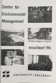
Booklet, University of Ballarat Centre for Environmental Management, 1996
The Centre for Environmental Management as established in July 1995 as a strategic development initiative to consolidate the University's position as a centre for industry linked environmenttal teaching, resarech and consultancy. Page 19 "SPECIAL INITIATIVES Establishment of field Research Stations Two areas of concentration of research effort for the Centre are the Otways in the south western Victoria and the Scotia Country in the rangelands of NSW. In both these areas it is essential that ther be a secure accomodation abase for research students. In the former case there is a need for a sheltered base to enable year round field work in cold wet conditions and in the latter a base with a reliable water supply and the facilities to allow field work in very hot dry conditions which prevail from much of the year. It has been an ibjective of the Centre to establish field stations at these two sites and considerable progress has been made through the year. (i) Nanya Field Station in the Scotial Country Through the generosity of the owner, Mr Rob Taylor, an unused homestead on Nanya Station was made available to the Centre. Largely through voluntary labour during research field trips during the year this previously derelict homestead has been restored to functionality and now has facilities for up to 20 research workers with a reliable water supply, cooking, washing, and refrigeration facilities. (ii) Cape Otway Resaerch Centre Negotiations have continued through the year with the potential lessees of the Cape Otway Lighthouse Precinct with the support of the Vice Chancellor and other potential user groups within the University these have reached a successful outcome. The University will be working with the lessees to develop the historic Telegraph Station as a dual purpose facility for interpretation and research." Black and white cover with clear plastic sheet. university of ballarat, centre for environmental management, martin westbrooke, richard mcewan, mal weston, john miller, nanya, telegraph station, cape otway, cape otway lighthouse station, cape otway telegraph station, field resaerch stations, s. hadden, peter dahlhaus, r.j. macewan, pat prevett, native vegetation assessment, fauna management, pest plants and animal research, soil and water assessment, conservation reserve management, paul ryan, richard macewan -
 Clunes Museum
Painting - PAINTINGS, David Williams
Images of; Horse Trough & Wagon Residence 94 Bailey Street Former Presbytery St. Thomas Aquinas Former Clunes Free Library Residence 25 Camp Street Monument 100 years of gold Clunes in Melb Monument Former butcher's shop Fraser Street Residence & shops 41-43 Fraser Street Clunes School of Mines Clunes War Memorial Residence 32 Leslie St Clunes Former suspension bridge Former St Paul's Vicarage 42 Service Street Former Police Office Former Police residence Portable Lock Up Former Dow Residence 9 Hill St Former Hall & Fire Station 2 Hill St St Paul's timber Church hall St Paul's Church Masonic Lodge 23 Service St St Paul's Pulpit Masonic Lodge interior Everhard cordial bottles Scythes in Clunes Museum Ascot Blacksmith shop Former Ascot hotel MIA Hall Ascot The Coghill Monument Former Methodist Church Coghills Creek Clunes Cemetery Chapel Maiden Hill Homestead shearing shed Beckworth Court stables Beckworth Cour shearer's quarters Former School Evansford Glengower Outbuilding Amerst Former Mortuary 46-50 Fraser Street Wood fired heater Beckworth court farm shed Gold mine trolley Servant's bells Maiden Hill cow bail Former South Clunes school 29 George Street 70 Fraser Street Former Post Office "Allowah" Clunes Street Ascot "Homestead" Beackwith Court "The Meat House" Beckwith Court "Shearing Sheds" Beckwith Court Evansford Community Hall 54 watercolours remaining from the 2003 exhibition held at Clunes, all unframed, depicting Clunes and surrounds architecture and streetscapes.watercolour, 2003 exhibition -
 Warrnambool and District Historical Society Inc.
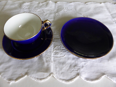
Crockery, Blue Cup Saucer and Plate, 1920s
This cup, saucer and plate are part of a tea set. It was given by Eva Carmichael, a survivor of the ship Loch Ard which was wrecked near Port Campbell in 1878, to Jane Shields, the young woman who supported her while she was recovering from her ordeal at Glenample homestead at Princetown. The two women remained friends after Eva Carmichael returned to her home in Britain and was married. Jane Shields also married and it was when her daughter visited Eva in England that she was given the tea set to take back home to her mother. Jane died in 1932 and Eva died in 1934 and the tea set was inherited by Jane’s daughters. In 1975 Jane’s daughter, Mrs Ann Fuller, donated a cup, saucer and plate to the Warrnambool and District Historical Society. The handle of the cup was mended. These items (cup, saucer and plate) are of high significance as they are closely connected to the wreck of the Loch Ard, and one of the two survivors, Eva Carmichael. Memorabilia connected to Eva Carmichael are precious and rare. These china items (cup, saucer and plate) are coloured royal blue and gold. .1 The cup has a gilt rim on the cup edge and base. There is a small crack on the side of the cup and the handle has been broken and mended. .2 The saucer is glazed on both sides with a small fault in the middle. It has a gilt band on the inner rim. .3 The plate is glazed on both sides with some evidence of scratching on the plate surface. It has a gilt edge. wreck of the loch ard, jane osborne (nee shields), eva carmichael, shipwreck coast history, bone china cup saucer and plate -
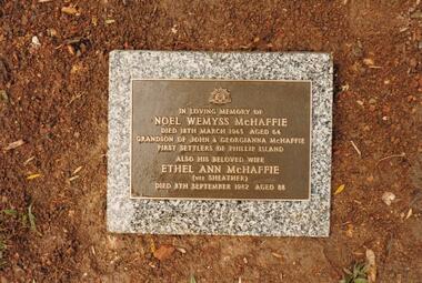
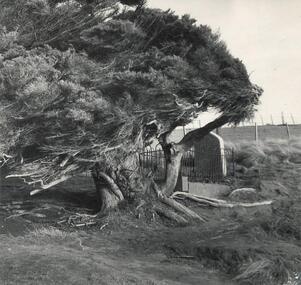 Phillip Island and District Historical Society Inc.
Photograph
One of a collection of over 400 photographs in an album commenced in 1960 and presented to the Phillip Island & Westernport Historical Society by the Shire of Phillip Island. A tragedy occurred at the McHaffie home in 1868. When a friend of John McHaffie, Captain Grossard, was accidentally shot when a fellow guest on the verandah of the homestead mishandled a gun during preparations for a hunt. Captain Grossard's dying wish was that he should be buried on a cliff near the sea. His lonely grave is still to be seen at the end of Grossard Point Road. This inscription appears on the headstone: "Sacred to the memory of William Phillip Grossard, formerly of Bideford, Devonshire, many years captain in the Merchant Service, who was killed by accidental discharge of a gun during a visit to Phillip Island, the 17th December, 1868. A new Headstone has replaced the original one.Photograph of the Lonely Grave and Cypress Tree at Grossard Point.local history, photography, the lonely grave at grossard point, black & white photograph, lonely grave, william grossard, grossard point., john jenner, bryant west -
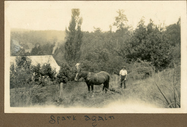 Mt Dandenong & District Historical Society Inc.
Photograph
The photograph shows Ted Child with his working horse Spark cutting grass at his homestead on Childs Road. The photograph was taken by his daughter Ivy Child. Ivy May Child (1910 – 1989) was the daughter of Arthur Edward (Ted) Child (1878 – 1964) and Ethel May Madden (1888 – 1970). Ted Child was the son of Matthew Francis Child (1839 – 1933) and Martha Jeeves (1857 – 1926). He was the grandson of one of the early pioneers Francis Child. Ivy grew up on the family property on Childs Road and took many photographs. Most of these are glued into her photo album. The album covered the years from c1927 – 1932. Ivy married Henry William Burgess (1906 – 1968) in 1944. The photographs remain in their original state in the album with individual copies made. Black and white photograph showing a man with a working horse cutting grass. They are working along a fenceline with a house visible alongside.Written below photograph in album - Spark againted child, child, horse, ivy child, homestead -
 Mt Dandenong & District Historical Society Inc.
Photograph
The photograph is from the album of Ivy Child. The photograph is a side view of the homestead of Ted and Ethel Child. Ted is recorded as having a well established garden. Ivy May Child (1910 – 1989) was the daughter of Arthur Edward (Ted) Child (1878 – 1964) and Ethel May Madden (1888 – 1970). Ted Child was the son of Matthew Francis Child (1839 – 1933) and Martha Jeeves (1857 – 1926). He was the grandson of one of the early pioneers Francis Child. Ivy grew up on the family property on Childs Road and took many photographs. Most of these are glued into her photo album. The album covered the years from c1927 – 1932. Ivy married Henry William Burgess (1906 – 1968) in 1944. The photographs remain in their original state in the album with individual copies made. Sepia photograph with a tree in the centre and a wooden building to the left. Bushes are in front of the building. A cleared area with rows of planted trees is visible with bush in the distance.ivy child, ted child, ethel child, kalorama, homestead, garden -
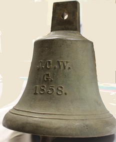 Wodonga & District Historical Society Inc
Functional object - Gordon Family Orchard Bell
The Gordons were architects and were associated with many buildings still standing in Albury and Wodonga, St Patrick's Church and the de Kerilleau Homestead among them. They established Vermont Orchard on 74 acres to the south of the Wodonga settlement. Here they grew fruit and nuts for the domestic and export market. The enterprising family also set about transforming some of the land by clearing it, creating streets and making general improvements. It was the biggest subdivision in Wodonga at the time. The 234 allotments in the Wodonga Estate were put up for sale by auction in May 1890. A total of 200 people were said to have attended. Gordon, William, Charles and Vermont streets in Wodonga are named after the family. This bell was used at the Vermont orchard to signal the beginning and end of the working day, as well as lunch breaks.The Gordon Family orchard bell is made of cast iron. It includes the inscription "J. C. W../G./1858." This is thought to represent the initials of John Gordon and sons Walter Joseph and Charles Goodwin Sylvester Gordon. There is some conjecture about this due to the date "1858". John was born in London, England in 1823 and died in 1880. Walter is generally accepted to have been born in 1857 and died 1903. In one family tree Charles is recorded as being born on 28 January 1858 but his birth was registered in 1860. The mystery of the date is therefore not fully resolved.On one side of the bell "J. C. W../G./1858."gordon family wodonga, gordon and gordon architects, vermont wodonga -
 Wodonga & District Historical Society Inc
Album - Ringer's River by Des Martin - Settings
Image 1: "de KERILLEAU" - Alongside Wodonga, home of the Watson family, was built by Charles Huon de Kerilleau, founder of the Wodonga Run. Huon took up his country in 1836, living then about 13 miles from the present homestead, the front portion of which was built about 1870. The actual age of an earlier portion is not known. Excellent for "Barmagulla". Image 2: "THE HERMITAGE" - Home of the Taylor family, is 13 miles from Wodonga. It was begun in 1852 and finished in 1854, and is the oldest occupied home in the area. The original atmosphere of the interior is maintained. As "Gooloora" its little balcony would provide a splendid vantage point for MacLough's speech. Image 3: Murray River Country above Granya, Victoria Image 4: Looking over Murmungee from the Buckland Gap near Beechworth, VictoriaThe album and images are significant because they document literature written by a prominent member of the Wodonga community. The presentation of this precis was supported by several significant district families and individuals.Coloured photos of venues suggested as settings for filming of the series. des martin, many a mile, ringer's river, northeast victoria stories -
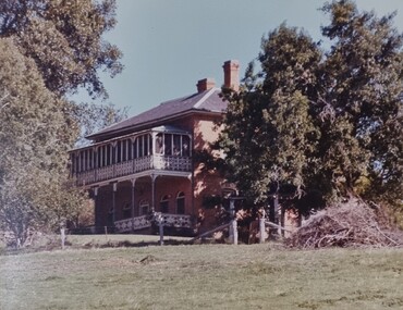
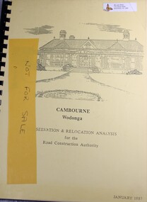 Wodonga & District Historical Society Inc
Booklet - Cambourne Wodonga : Conservation & Relocation Analysis for the Road Construction Authority, John & Thurley O'Conner, 1987
Research paper into the viability of relocating Cambourne Homestead in 2006 in order to make way for the widening and upgrade of the Hume Highway.non-fictionResearch paper into the viability of relocating Cambourne Homestead in 2006 in order to make way for the widening and upgrade of the Hume Highway. cambourne homestead wodonga, heritage building wodonga, carkeek family, potter family, building relocation -
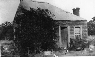 Stawell Historical Society Inc
Photograph, Four Posts Inn in Glenorchy -- Building no longer exists
Four Posts Inn. Glenorchy built about 1841 by John Gleeson on the Wimmera River at Glenorchy. Building no longer exists as burnt down in 1944. Located on the site now known as Glenorchy (Victoria). Glenorchy is approximately 20Km from the former Ashen's pastoral run occupied by Dugald McPherson. The Four post Inn was a "Staging Camp" for the police escort route during the transportation of gold by road from Mount Alexander gold fields (Bendigo) to Adelaide South Australia in 1852-53. The police escort is known to have called in at Ashens homestead to visit Dugald McPherson. The Four Post Inn was the scene on the occasion of and encounter between the police escort and bushrangers. At a later date The Four Post Inn was a staging camp for the horse drawn coach service between Stawell and Horsham.Small weatherboard building with no verandah and tree blocking the view. Cat in front of doorway.stawell -
 Phillip Island and District Historical Society Inc.
Photograph Album, Kodak, Phillip Island Cemetery, c 1990
The Album was compiled by Nancy McHaffie late 1990's, with the assistance of Edith Jeffery's, with her book "Garden of Memories" and extensive knowledge of Phillip Island. The Cemetery lies back from the road and is surrounded by Manna Gums, rare Peppermint Gums, Blackwoods and other native trees. In all 25 acres of land were set aside as Crown Land in the land settlement of 1868. There are 6.2 acres of wetlands near the cemetery entrance.4 photographs relating to the McHaffie family. 466-15 & 466-16: Noel Wemyss & Vernon Suter Wemyss McHaffie were grandchildren of the first permanent European Settlers of Phillip Island (John David & Georgianna McHarrie who leased the whole Island as a sheep and cattle run for 45 years until Closer Settlement in 1868 reduced their holding to 640 acres and who are buried at the St. Kilda Cemetery, Melbourne). Noel's ashes are interred at the Phillip Island Cemetery and Vernon's were scattered at Ventnor Philip Island at the site of the original homestead. 466-17 & 466-18: As per the Plaque: "Mulberry Tree: Muberry cutting from original tree planted by John D McHaffie First Settlers Phillip Island 1842. Plaque by courtesy Cherry McFee 1987.phillip island cemetery, nancy mchaffie, edith jeffrey -
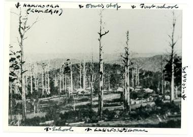 Mt Dandenong & District Historical Society Inc.
Photograph
Iconic photograph taken by Edgar Dower on Ridge Road in 1913 from an area known as Point Clear that shows the buildings of early Mt Dandenong before the CRB road went through in the 1920s.Black and white photograph with tall, dead trees in foreground and a view of hills in the distance. Buildings can be seen across the centre of the photograph. There are handwritten annotations around the border with arrows referring to areas in the photograph. Reverse of photograph has handwritten description by John Lundy-Clarke.Front from top left: Namoora (Lumeah), Dower's Shop, First school, Talent's, Langford's house, School. Reverse: 1913 view from O'Halloran's LOT 4, Section 3 on Ridge Road. Showing Lumeah (Namoora) Farndons Road (fence) School, Lowes House?, Falls Road Shop (Dowers) Langford's Falls Road (LOT 9, Section 1) Shed on Colomb's LOT 19, Sect 2 Colomb's House (Fergusons) First school Campbell's Blythes Road Lil Badenhop's P.O. In middle distance - Talent's homestead and sheds.point clear, namoora, lumeah, langford, dower, talent, colomb, ferguson, campbell, farndons road, mt dandenong school -
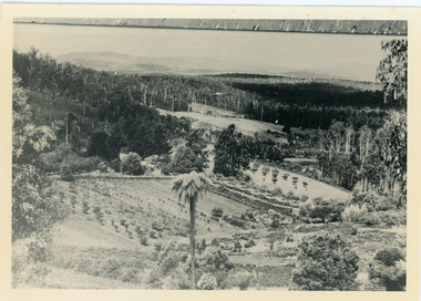 Mt Dandenong & District Historical Society Inc.
Photograph, Harmony Vale, c1913
View of Harmony Vale, the original Kalorama settlement taken from Barbers Road. Child's sawmill can be seen (centre) with the log yard to the right. Richardson's home "Harmony Vale' is in the orchard above the logs.Black and white photograph copied from a Rose Series postcard showing the area known as "Harmony Vale' - the original Kalorama settlement. Child's sawmill is in the centre.Rose Series Photo of Harmony Vale on the Olinda Creek taken from Logans Lot 28. Link Rd crossing centre Shiloah complex left centre. Richardsons (Jeannie’s) “Mt Calvin” between trees above tree fern. Isaac Jeeves house with the tree fern floor among trees against forest right centre. Mill yard with logs above cultivated flat. Mill to left. “Harmony Vale” homestead among orchard above logs. “Glenrivers” in gully at top of clearing. About 1913. Copied JLC 1973harmony vale, harmony vale, child's sawmill, sawmill, barbers road, richardson, shiloah -
 Kew Historical Society Inc
Album, Eva Grant, Historic Buildings in Victoria & New South Wales, 1919-c.1962
One of three scrapbooks created by Eva Grant, a past member of the Kew Historical Society which were donated by her niece, Julie Thomson, in 2013. The scrapbook includes photographs and descriptions of the following sites. (Many of these are now demolished and so the photographs and descriptions may be rare records of a site.) Sites include: Abbotsford (Vic) - Abbotsford Convent, Mayfield (c.1962), prefabricated house - Church street Armadale (Vic) - church (c.1959) - Thomson & Wattletree Roads Arthur’s Seat (Vic) - McCrae homestead Ballarat (Vic) - Memorial plaque on site of Bentley’s Hotel, Memorial on site of Eureka Stockade, Early municipal buildings - East Ballarat, Adam Lindsay Gordon’s cottage - Botanical Gardens, View from Sovereign Hill, Shell house Broken Hill (NSW) - panorama (1963), Flying Doctor’s base (?1963) Eltham (Vic) - Hassell’s outdoor art gallery Essendon (Vic) - Niddrie Homestead and stables (1963) Geelong (Vic) - first Bishopscourt Hawthorn (Vic) - Convent (1930), The Hawthorns, Keilor plains (Vic) - pioneer homes, pioneer cemetery Kew (Vic) - Roseneath (1951), Tarring - Ruyton, Turinville, house - Foley street (c.1960). Malvern (Vic) - church Mount Ridley (Vic) - Summerhill Melbourne (Vic) - Old Brewery - Custom’s House Lane (1960), Customs House, Scott’s Hotel (1962), Western market (c.1960) Phillip Island (Vic) - Grave Toorak (Vic) - Mandeville Hall, Merna (sic) - Arthur Streeton’s house, Toorak House Wentworth (NSW) - Harvey’s Hotel, Sturt Memorial, Sturt’s Tree, Wentworth Gaol Williamstown (Vic) - Williamstown Dairy Yan Yean (Vic) - Bear’s Castle (c.1947) Beveridge/Big Hill (Vic) - Kelly’s cottageImportant photograph record (and notes) about historic buildings in Victoria.38-page scrapbook with additional text created by Eva Grant, a past member of the Kew Historical Society. In addition to the 68 photographs, there are two postcards and a number of publications/handouts.collected by Eva on her trips to heritage sites in Victoria and New South Wales. The pages of the album can be viewed in the image carousel above. Most of the photographs of heritage buildings were taken in the early 1960s.See imagesheritage sites - victoria - australia, eva grant, scrapbooks - 20th century -
 Eltham District Historical Society Inc
Photograph, Fay Bridge, Rosehill Homestead, EDHS Heritage Excursion, 6 July 2019
July Excursion July 6, 2019 - Exploring Lower Plenty The predominant feature of this walk in the Bonds Road area, Lower Plenty is the large number of magnificent old River Red Gums that line the route. These trees are of the spreading woodland form of this species indicating that they must have been originally growing in a reasonably open setting. The walk also includes parts of the historic Cleveland Estate and the homestead “Rosehill” established by pioneer farmer Henry Stooke. This area was the site of the first recorded European settlement in what was to become the Shire of Eltham when the Willis brothers arrived in the late 1830s. From the southern part of Cleveland Avenue there are extensive views across and along the Yarra Valley. An article on the history of this area was contained in Newsletter edition 201, November 2011. The walk will start at the at the corner of Bonds and Stawell Roads, Lower Plenty - EDHS Newsletter No. 246 June 2019fay bridge collection, 2019-07-06, blackburn bricks, eltham district historical society, heritage excursion, rosehill homestead, lower plenty -
 Eltham District Historical Society Inc
Photograph, Fay Bridge, EDHS Heritage Excursion, Edendale Farm, 5 May 2018
May Excursion – Edendale Environs Edendale Community Environment Farm in Gastons Road, Eltham now operates as Nillumbik Council’s environmental centre. The historic homestead has undergone a significant restoration and there is on-going development of the site consistent with its community education purpose. The house and the gateway sculpture “The Fences Act” are covered by a Heritage Overlay in the Nillumbik Planning Scheme. Our May excursion will comprise a walk through the farm property and will radiate to other nearby places of historic interest. These will include the site of the Eltham North Adventure Playground to discuss its history and destruction by fire (see page 1 article). Also nearby is Colemans Corner where the early road system has undergone some unusual changes. If time permits we may visit some other nearby places of interest. - EDHS Newsletter No. 239 April 2018fay bridge collection, 2018-05-05, edendale community farm, edendale farm, eltham district historical society, heritage excursion, activities -
 Kiewa Valley Historical Society
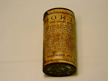
Can Mortein Powder, late 1870s to early 1920s
The can(product) of powdered Mortein was used throughout Australia and especially in rural regions where environmental conditions of crops, cattle and other livestock resulted in greater amount of "invasions" from insects. The eradication of unwanted invaders into the homestead required either manual extermination or a relevant poison which in low doses would not affect humans. Fly squats were still a good measure of eradication of flying pests however those lurking in cupboards or "hard to get at" locations needed a method, such as the Mortein powder to do the deed. This product and especially this can was used at the fore front of pest eradication. Powders and pellets are still in use 100 years later and the core ingredient is still environmental friendly and meets health conscious modern Australians. The basic product has survived the passage of time and was invented by a German immigrant to Australia in the late 1800s.This can and what it represents to rural households and outhouses, is in some ways immeasurable to the peace, health and tranquility within the household of all the families within the Kiewa Valley. Although small in size the relief of those within the sanctity of the home from annoying pests is enormous. The relief not only physical but also mentally to those residents, from the sometimes grueling and painful rural existence in a "sunburnt" countryside cannot be truly expressed in words. Kiewa Valley residents are part of the sometimes harsh rural environment where the introduction of helpful products such as this powder are noticed and used more prolifically. Any product, especially invented within Australia, which allows for a easier existence is of a great significance.This small cylindrical can contains powder of crushed the chrysanthemum flowers(pyrethrum extract) and has two circles of small circular perforations in the lid (to allow contents to be sprinkled onto other surfaces). It is constructed of mild steel with both ends crimped onto the main cylinder. A paper information label has been adhered to the outside of the cylinder.Printed on the outside label is: 1st line "MORTEIN!" 2nd line "THE GREAT INSECT DESTROYER" underneath "(Registered)" and underneath "It is without doubt the best and most reliable Insect powder in the World" underneath this line "In order to use Mortein with profit it is best to get a Mortein spreader through", next line "which by pressure of the hand the powder is ejected and well diffused." An inflection mark appears over the e in "Mortein" as to signify that the word "mort" is french for (dead) and the "ein" is german for "one". The word "mortein" therefore is diffused and translated into "dead one". A thin line separates the above from the list of insects which the powdered contents will kill together with the suggested application targets. T the bottom of the instructions is printed the manufacturer "J. HAGEMANN PTY. LTD., MELBOURNE," Below is "Sole Proprietors"natural insecticide products, environmentally friendly products, household pest dispensers, australian inventions -
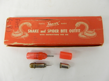 Kiewa Valley Historical Society
Box First Aid, Snake and Spider Outfit, Circa 1940's
At the time of manufacture, circa 1940's, the first aid treatment for snake bites, was to lance(cut) open the bite, wash it out and apply a ligature or tourniquet between the bite and the heart. This method was abandoned later after scientific evidence suggested that it was better to stop the blood system from carrying the poison to the heart (pressure immobilization). Australian snakes do not have long fangs therefore deep incisions into main arteries is rare. This research took many years to develop therefore the information supplied with the "Sanax" kits of this era is well outdated. Rural areas were more attuned to the possibilities of snake activity on farms, in sheds and in out houses and farm homesteads. This was not the case for mainly city and large townships environments. The mice plagues in wheat areas during the warmer month s has always been a high risk time for encountering snakesThese snake bite kits were issued to workers on the Kiewa Hydro Electricity Scheme. Some of these snake bite kits were kept at doctor's surgeries e.g. Bogong Village, House 13. The kit was carried by bushwalkers, scouts, farmers and high plains cattlemen. This item is of significance because it demonstrates the main dangers faced by all rural industries and towns, especially remote areas, and the portable remedies that where required as a necessity of the Australian bush environment. This item was in use at a time when the air ambulance and rescue facilities were not in existence and remote locations were more isolated and the availability of anti venom was hard to obtain locally.This item is a red coloured cardboard box(250 - 300 g/m) with white writing and containing the following 12 items. 7 clear red coloured capsules, 2 opaque red plastic capsules, 2 wooden capsules and 1 brass screw on capsule. The capsules are divided into two sections (compartments) horizontally. Each compartment has a screw lid. One compartment contains a lancet (for piercing the snake bite) and the other compartment contains the "Condy's" crystals compete with tightly rolled instructions.On top of the pull up lid, and flanked by two coiled snakes (at the strike position) is printed: "Trade Sanax Mark" below this " SNAKE and SPIDER BITE OUTFIT" and below this with instructions for use". Front side: "Sanax snake and spider bite outfit" underneath "Nepean Highway Morabbin" The later printing has been severely scratched but decipherable. The back side of the box has "Note to the retailer" and due to wear no more of the writing can be read. Each side of the box is printed "SANAX" snake, spider, first aid, kiewa hydro scheme, portable medical supplies -
 Mt Dandenong & District Historical Society Inc.
Photograph, Isaac Jeeves' Barn
Large barn built c1886 by Isaac Jeeves the younger on his property where the homestead 'Shiloah' stood. The barn was reputedly made from timbers split from only one messmate tree. Originally the home of Isaac Jeeves, brother of Ellis Jeeves, ‘Shiloah’ was enlarged to take guests in the early 1900s. It was situated close to a beautiful fern gully and Isaac and his family capitalised on this by setting out walking tracks through the ferns. They charged 1/- to walk through and this included afternoon tea in a garden setting. ‘Shiloah’ was a popular tourist attraction but the making of the Olinda Creek Road destroyed the fern gullies and, by the 1930s, it was all finished. John Lundy-Clarke grew up in the Kalorama/Mt Dandenong area and later in life (1972-74) began to write a comprehensive history of the area working from an original settlement map in an effort to cover all areas.Black and white photograph showing a large wooden structure surrounded by trees. Handwritten inscription on reverse by John Lundy-Clarke.Home of Isaac Jeeves the younger. Built about 1886 of timbers split from one messmate tree. Photo 1973isaac jeeves the younger, barn, kalorama, shiloah, messmate -
 Mt Dandenong & District Historical Society Inc.
Photograph
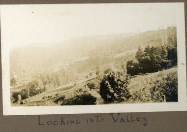
This photograph is from the Ivy Child album and shows a scene across the Kalorama Valley. The roof of the Kalorama Homestead is right of centre with cultivated areas around it. Walter Jeeves would have been the owner at this time. Ivy May Child (1910 – 1989) was the daughter of Arthur Edward (Ted) Child (1878 – 1964) and Ethel May Madden (1888 – 1970). Ted Child was the son of Matthew Francis Child (1839 – 1933) and Martha Jeeves (1857 – 1926). He was the grandson of one of the early pioneers Francis Child. Ivy grew up on the family property on Childs Road and took many photographs. Most of these are glued into her photo album. The album covered the years from c1927 – 1932. Ivy married Henry William Burgess (1906 – 1968) in 1944. The photographs remain in their original state in the album with individual copies made. Sepia coloured photograph showing a sweeping scene across a lightly treed valley with hills in the background.Written below the photograph in the album: LOOKING INTO VALLEYkalorama homestead, kalorama, valley, ivy child, walter jeeves -
 Stawell Historical Society Inc
Photograph, "Schoolers" Homestead at Lake Lonsdale 1866
Schoolers Homestead Lake Lonsdale. Part of a collection of Photographs by Mr. O.G. Armstrong as commissioned by the Shire of Stawell for the Inter-colonial and Paris Exhibition in Melbourne in 1866. Similar Photo Scoullar station Rosehill Cat No 3888 G.F. Scoullar originally from Canada, according to W.G. Sharply in his 1930 Stawell Borough History, was a member of the Stawell Shire Council 1870-1888 and president 1875-1876. Maynard Ord in Stawell Past and Present says G.F. Scoullar, M. Brinkman and one other, took up small pieces of land fronting Lake Lonsdale. The owners of the Squatting Run, presumably Ledcourt, charged them with illegal occupation. They were heavily fined at Pleasant Creek Court, or in default gaol. As they could not afford the fine, some friends raise the money. Note re the spelling of ‘Schooler’. Variations in local records are ‘Schoullar’ and ‘Scoullar’. stawell education -
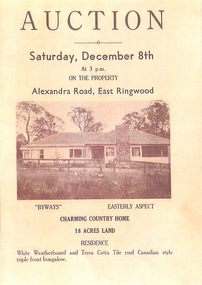 Ringwood and District Historical Society
Memorabilia - History Timeline, Byways Homestead, Coolooli Estate, Ringwood East, 1878-2008
Development of Coolooli Estate with property titles and leaflets for the sale of "Byways" homestead, 4 Byways Drive, Ringwood East. Also the house at 9 Walhalla Drive, Ringwood East. Correspondence between David Best and Richard Carter re the estate. Coolooli subdivision includes lots fronting Isabel Avenue, Byways Drive, Coolooli Court, Walhalla Drive and Cleland Street. Property Titleholders include: George Blood William Chelman Thurgood Frederick Deine Laurie Arthur Wigley Charles Patterson Mary Aphra Patterson John Douse Langley August DiGilio Kenneth Ross Landy Mervyn MacPherson Brewer Richard Blennenhassett Best Jessie May Cleland John Brian Little Robert William Campbell Lynette Marie Campbell Lorraine Ruby Campbell David Charles Nicholls Barbara Janette Nicholls Ian Finlay Packer Nellie Packer -
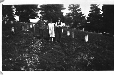 Southern Sherbrooke Historical Society Inc.
Photograph - Percy Johns, 1930s
B&W photo of Percy Johns, an unknown woman and a farm worker during potato digging at Glen Park Farm, Selby, in the 1930s. Percy Johns stands on the left, wearing a dark hat, jacket with deep pockets, and pants. He is holding a shovel in his right hand, and his left hand is on his hip. Beside him is a young unidentified woman with dark hair, who is wearing a loose dress with a drop waist. Beside her is an unidentified farm worker, wearing a hat, dark waistcoat and pants, and pale shirt. He has a pipe in his mouth. They are standing between rows of potatoes. On the left of the photo there is a row with potatoes lying on the ground. There are at least eight full bags of potatoes in the field. Behind the trio is what appears to be the cypress avenue running down to the homestead out of range on the right of the photo. -
 Eltham District Historical Society Inc
Journal, Peter Doughtery, ArtStreams: News in Banyule, Darebin, Manningham, Nillumbik & Yarra; Vol. 6, No. 4, Sep-Oct 2001, 2001
Vol. 6, No. 4, Sep-Oct 2001 CONTENTS Vale Andy Ingham and Nina Christensen 2 What is this thing called jazz 3 Abdullah Ibrahim's musical journey Joy Hester The Goodlooker at Heide 8 A Sense of Place 10 Seren Little on the art of Peter Block Homecoming 12 Short Story by Sophie Avgoulis Banyule Young Artists Award 17 The winners for 2001 Australian Classical Music 20 Elizabeth Scarlett Celebration Quilts 2001 21 Gerry Smith Dumnoochin 22 History goes up in smoke by Mandy Haley Bundoora Homestead 23 From Horse Stud to Art Gallery Wildflowers of Victoria 25 Book Review by Gwen Ford CD Reviews 26 Cate Bailey, Andrew MacGregor, Judy Turner ARTIN' ABOUT 27 Wining & Dining 30 Poetry in motion 32 Sandy Jeffs plays tennis "Peter Dougherty has been involved in the local art scene for many years. As publisher and editor of the arts magazine Artstreams, his comments on the various branches of the arts are widely respected. His "The Arts" column in the Diamond Valley Leader presents a brief summary for a much wider cross section of the local community. Peter also operates his own gallery and the Artstreams Cafe at the St Andrews market. Peter has a wealth of knowledge about present day and historical aspects of local art and artists." - Eltham District Historical Society Newsletter No. 161, March 2005Colour front and back cover with feature articles and literary pieces with photographs and advertisements printed in black and white. 36 pages, 30 cm. Vol. 1, no. 1 (Nov. 1996) - Vol. 10, no. 5 (summer ed. 2005/06) art streams, andy ingham, nina christesen, abdullah ibrahim, nillumbik art in public places award, banyule winter festival, joy hester, heide museum of modern art, seren little, sophie avgoulis, plenty views golf park, dynamic vegies, montsalvat, banyule young artists award, kyla jane hunt, perin roberts smith, jonathon woods, laura hassaram, lisa o'gorman, quilts, gerry smith, dunmoochin, mandy hayley, kinglake gallery, eltham wiregrass gallery, bundoora homestead, bulleen art & garden centre, melboune international chamber music competition, thompson's pharmacy -
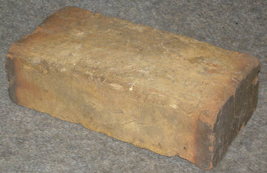 Heyfield & Districts Historical Society
Brick
James Tyson (8 April 1819 - 4 December 1898) purchased Heyfield Station from the Firebrace family in the late 1860s. Tyson referred to Heyfield as his "cabbage patch". Tyson was famous for insisting his workers were accommodated at the same standard as he was, and arranged for George Drew (1834-1892) and his family to come to Heyfield from his home station at Deniliquin to make bricks for the homestead and for the workers quarters. As far as can be ascertained they arrived in 1868, and selected land that became known as the Brick Yard. After making the bricks for Tyson he operated as would any normal brickmaker. George carried on the business until his death, with it being then operated by his sons Jack and Henry. Many buildings in the district contain Drew bricks, which are sometimes smaller than normal bricks. The most accessible example is the first Anglican Church of 1874, now in the school grounds.This brick has historical significance as an example of one of the early bricks made by the family, similar to those made for James Tyson, an important figure in Australian history. It has community significance as the story of the Drew family (who still remain in Heyfield) provides the community with a strong link to Tyson. The family has remained linked to the Anglican Church (having made the bricks for the first church), as well as being active in the wider local community.A single clay brick with two thumbprints in diagonal corners, ends glazed.brick industry, brickmaking, bricks -
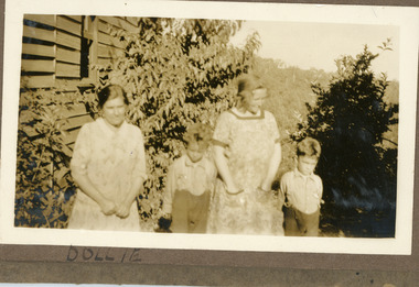 Mt Dandenong & District Historical Society Inc.
Photograph
The photograph is from the album of Ivy Child. The woman standing LHS is Ethel Child, wife of Ted Child and mother of Ivy. The woman with her hands in her pockets would be the mother of the two boys as she has appeared with them in other photographs. The building is the Child Family Homestead in Childs Road, Kalorama. Ivy May Child (1910 – 1989) was the daughter of Arthur Edward (Ted) Child (1878 – 1964) and Ethel May Madden (1888 – 1970). Ted Child was the son of Matthew Francis Child (1839 – 1933) and Martha Jeeves (1857 – 1926). He was the grandson of one of the early pioneers Francis Child. Ivy grew up on the family property on Childs Road and took many photographs. Most of these are glued into her photo album. The album covered the years from c1927 – 1932. Ivy married Henry William Burgess (1906 – 1968) in 1944. The photographs remain in their original state in the album with individual copies made. Sepia coloured photograph showing two womwn and two young boys standing alongside a weatherboard wall and surrounding bushes. The boys are wearing shorts with long sleeved shirts and the women casual dresses.Handwritten below photograph in album: DOLLIEethel child, ted child, childs road, ivy child, kalorama -
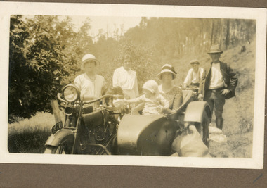 Mt Dandenong & District Historical Society Inc.
Photograph
The photograph is from the album of Ivy Child. Everyone in the photograph is well dressed for a day of visiting. The woman without the hat standing to the LHS appears to be Ethel Child.The location is most likely the road outside the Child Family Homestead of Ted and Ethel Child - Childs Road. Ivy May Child (1910 – 1989) was the daughter of Arthur Edward (Ted) Child (1878 – 1964) and Ethel May Madden (1888 – 1970). Ted Child was the son of Matthew Francis Child (1839 – 1933) and Martha Jeeves (1857 – 1926). He was the grandson of one of the early pioneers Francis Child. Ivy grew up on the family property on Childs Road and took many photographs. Most of these are glued into her photo album. The album covered the years from c1927 – 1932. Ivy married Henry William Burgess (1906 – 1968) in 1944. The photographs remain in their original state in the album with individual copies made. Sepia coloured photograph showing a group of people on a dirt road. A motorbike with side car is in the foreground with a woman and baby in the side car and a young woman standing beside it. Another motorbike is behind this with a young man wearing a cap sitting on it. A man wearing a hat is at the rear of the motorbike with side car and a woman without a hat is standing to the LHS. ethel child, motorbike, side car, child family homestead, kalorama