Showing 751 items
matching inspection
-
 Eltham District Historical Society Inc
Slide, Maroondah Aqueduct, Research, Victoria, 22 Mar. 1981
An inspection tour of the Maroondah Aqueduct was undertaken by the Shire of Eltham Historical Society on Sunday, March 22nd, 1981, commening where the aqueduct crosses Main Rd., Research, just below Eltham College. The Maroondah Aqueduct was part of Melbourne’s water supply system. It carried water over the 66 km from the Maroondah Reservoir on the Watts River at Healesville to the Preston Reservoir. Of this length, 41 km were open channel, 10 km, tunnel through hills and 15 km in 14 inverted siphons across stream valleys. The route of the aqueduct is north of Tarrawarra and Yarra Glen, along the Yarra escarpment south of Christmas Hills and crossing Watsons Creek into the present Shire of Eltham near Henley Rd. The eastern part of the route lies entirely within the former boundaries of the shire. The aqueduct passes south of Kangaroo Ground to Research and crosses the Diamond Creek by siphon at Allendale Rd., Eltham North. It then extends to Reservoir via St. Helena, Greensborough North and Bundoora. Water first flowed through the aqueduct in February 1891 when it was fed by a diversion weir on the Watts River. Records of the building of the aqueduct indicate that it was a significant construction achievement. The present Maroondah Reservoir was completed in 1927 and the aqueduct was enlarged at that time to take increased flows. About 1971 the section of the aqueduct through and north of Research was replaced by a large pipe and that section of the channel is now unused. The channel has remained largely intact (unlike sections at Greensborough and Bundoora where long lengths of the disused aqueduct have been demolished or filled in). The M.M.B.W. relinquished control of the disused aqueduct reserve which is crown land and the Shire of Eltham took control of this section of the reserve as a linear park. The Maroondah Aqueduct is considered to be an important historic structure, not just to the local area but to the metropolitan area generally. It is considered important to preserve substantially intact long lengths of the disused aqueduct, together with its bridges and other associated structures. 35 mm colour positive transparency (1 of 5) Mount - Agfachrome Agfa CS System black 8 dotsactivities, heritage excursion, maroondah aqueduct, research (vic.), shire of eltham historical society -
 Orbost & District Historical Society
black and photograph / postcard, 1.4.1908
This postcard was sent to Annie Gilbert (Mrs John Gilbert) of Tullagoota, Orbost. It was written by "Grace", probably her sister, Grace Cameron Annie Gilbert was the daughter of John Cameron who selected the first land on the Snowy River flats. This is a photograph of the original Orbost / Snowy River Bridge , a suspension bridge which opened in 1893. It has been taken when the Snowy River was in flood. It is similar to other photographs held in The State Library, Victoria. The Snowy River Mail and Tambo and Croajingolong Gazette Sat 12 Aug 1893 records the opening of this bridge as "the most important public event that has yet been commemorated in Eastern ......The Messrs McLeod, with whom the first settlement of this district is generally associated, took up their residence on the eastern bank of the Snowy River about the year 1841 or 42. The late Mr W. Roadknight and Mr T. T. Stirling took possession of the territory on the western side of the Snowy about 35 years ago. During the occupation of the country by cattle owners, very little progress was made in the way of roads and bridges, and except to the hardy and lexperienced bushman, it might have been generally regarded as inaccessible. About the year 1877, however, the late Mr James Robertson eldest son of Mr James Robertson, of Lochend farm, selected land now occupied by his father, about four miles from Orbost on the west bank of the river, Mr John Cameron visited the. district shortly after a .tour of inspection and returned later with his brothers, James and Alick Gameron, but found that during their absence Mr Ernest Watt had found his way on the scene and pegged out a selection, thus anticipating the advent of the Camerons by about 12 hours. We understand that a Mr Kidd, who selected the property now occupied by Mr W. J. Ross, at Pumpkin Point, was one of the earliest batch of settlers.........."This item is associated with Annie Gilbert (nee Cameron) reported to have been the first white girl to be born in Orbost. It is a pictorial record of the suspension bridge over the Snowy River which has since been replaced twice.A faded black / white postcard of a bridge across a river. There are cattle in the river and the banks are tree-covered.on back - a hand-written letter addressed to Mrs J. Gilbert Tullagoota Orbost.cameron-annie suspension-bridge-orbost snowy-river-orbost -
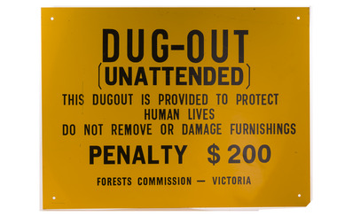 Forests Commission Retired Personnel Association (FCRPA)
Dugout sign, Post 1966
Considered in terms of both loss of property and loss of life, the Black Friday bushfires on 13 January 1939 were one of the worst disasters to have occurred in Australia and certainly the worst bushfire up to that time. The fires burnt 2 million hectares, 69 sawmills were destroyed, 71 people died, and several towns and sawmills were entirely obliterated. Among those killed were four men from the Commission The subsequent Royal Commission conducted by Judge Leonard Stretton has been described as one of the most significant inquiries in the history of Victorian public administration. Its recommendations led to sweeping changes. In addition to building dams and water points, the Stretton Royal Commission recommended expanding and controlling the use of bushfire dugouts at forest sawmills. Well-constructed dugouts had saved the lives of many sawmill workers and their families during the 1939 bushfires. But in some locations, they had proved fatal. Dugouts became mandatory for those few sawmills that remained in the forest after the 1939 fires. Many remote logging coupes and FCV roading camps also had dugouts. The local District Forester was required to make annual pre-season inspections of all dugouts on State forests and those within the Fire Protected Area (FPA). Some were built privately on private land. Most were primitive construction with a log or corrugated iron roof covered with earth. A hessian bag often hung at the entrance to keep the heat and smoke out. But they were dark and damp with snakes and other creepy crawlies often lurking inside. By 1940-41 there were 19 new dugouts constructed by the Commission and a further 128 by forest licensees. Ten years later there were 8 new Commission dugouts and 21 new ones built by other interests. By 1960-61 the rate of new builds was declining but the Commission still managed 103 dugouts while 127 were looked after by others. However, as the forest road network improved and gave all-weather access to modern two-wheel-drive vehicles the reliance on dugouts receded.Large metal sign that was positioned near forest dugoutsbushfire, forest signs, forests commission victoria (fcv) -
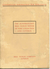 Ballarat Tramway Museum
Manual, Bell Punch Co, "The Automaticket Bell Punch System of Fare Collection and Control", c1935
Yields information about the method that the State Electricity Commission of Vic undertook interviews for staff appointments. Gave advice of the era for such interviews and objectives of the interview.Thirty page book printed on heavy light brown paper, stapled with an folded card cover titled "The Automaticket Bell Punch System of Fare Collection and Control". Describes the Automaticket system, has samples of traffic tickets pasted in the book, diagrams, drawings, gives details of the components and method of operation in particular ticket inspection, ticket and checking back office functions. Published by the Bell Punch Company of London early to mid 1930's? Cover and each page headed "Confidential Information for Executives". Has a photo of South Western Roadlines double deck bus with a conductor. See also Reg. Item 3629 for another version of the pamphlet for this machine. In the rear cover of the book, folded and stapled to give a pocket, are listed three forms that would have been provided with the book - not with the collected copy. -However in the pocket were eleven 11 "Ticket Issue Machine" or "TIM" tickets - eg City of South Melbourne library fine, packing slips, sample meal tickets, Army canteen beer tickets, and sample bus tickets - including one pinned to a business card - John Bolland of Eastern Suburbs Omnibus Service who were the agents for the TIM machines. (image btm3645i3) Card has date of "4-1-50". Also three sample Bell punch tickets and one ultimate machine ticket - two 1d tickets. As well at the time of acquisition were a SEC Special Pass - to Reg Item 3648 and a SEC Staff Pass ticket - to Reg item 3649. Full scan of document added as a pdf file 5/6/2019. trams, tramways, tickets, ticket machines, buses, bell punch -
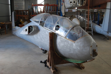 Australian Gliding Museum
Machine - Glider – Sailplane, 1963
The Bocian is a versatile training sailplane that first flew in 1952. The type has been modified in several respects over the course of production by SZD (tailplane and rudder in particular). About 600 have been built; many for export to 27 countries (including Australia). The aerobatic capability and fine performance (best glide ratio of 26) has enabled the Bocian to be used to train competition pilots as well as those of lesser experience. Many world gliding records were set in the 1950s and 1960s in Bocian gliders. The Museum’s example is a type D test flown in Poland on 3 and 4 April 1963. It was imported into Australia in September 1963 by Austerserve Pty Ltd. The first owner was the Alice Springs Gliding Club and the glider had name “Cumulus” painted on the side of the fuselage (since removed). The glider had recorded 726 hours 46 minutes flying time from 2138 launches as at July 1967 when it was transferred to the Darwin Gliding Club. It appears that the glider was damaged in June 1968. The substantial repairs to the fuselage, both wings and tailplane and other minor repairs were completed on 13 October 1968. The glider continued flying with the Darwin Gliding Club until August 1969 at which time the service to that club amounted to 59 hours 7 minutes flying time from 348 flights. Between August 1969 and August 1976 no flights are recorded in the logbook. It is understood that on its last flight at Bachelor, south of Darwin in the Northern Territory (August 1969) it was severely damaged when it crashed after spinning while being auto-tow launched (although this is not expressly mentioned in the logbook). Reg Hancock purchased the damaged glider and rebuilt the port wing and restored it to airworthy condition (September 1976). It was then transferred to Colac, Victoria, and used by the Colac Gliding Group at the Yeo airfield until February 1981, adding another 153 hours from 403 flights to the glider’s record. After airworthy inspection in September 1982 the glider was used by the Geelong Gliding Club until 1983 (logbook details not held). The 20 year survey was then due and the glider fell out of service. In the course of the most recent restoration attempt it was discovered that the glue used in construction had deteriorated and that it was no longer feasible to bring it back to an airworthy condition. Subject to restoration, this exhibit may be representative of the 1950s - 1960s Bocian two seat sailplane typeThis exhibit is a large two seat glider /sailplane of wood and fabric construction. All components are present with the exception of instruments. However, at the time that the aircraft was transferred to the Museum it had been taken apart for major restoration work. As received it is stripped of the top coats of paint and a number of components (including, amongst others, tip fairings, nose cone and cockpit elements) that were removed for facilitating the repair process. The glider, serial number 803, was registered as VH-GNLaustralian gliding, glider, sailplane, bocian, cumulus, alice springs gliding club, darwin gliding club, colac gliding group, geelong gliding club, hancock -
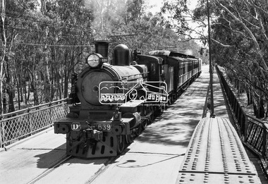 Eltham District Historical Society Inc
Photograph, VR Commissioner's Special train, steam locomotive D3-639 crossing the Echuca-Moama Road Rail Bridge over the Murray River from Moama, NSW to Echuca, Victoria, 1962
VR Commissioner's Special train, steam locomotive D3-639 crossing the Echuca-Moama Road Rail Bridge over the Murray River from Moama, NSW to Echuca, Victoria. Commissioner Edgar Henry Brownbill on footplate, 1962. Commissioner Edgar Henry Brownbill was in office 1957 to 1967. George Coop advises - "The train on the Eltham/Moama bridge is actually the Commissioner’s Special on one of its inspection tours of the VR rail system. This was a very grand special train with accommodation for the Commissioner and staff in carriages also used once for the Royal Train and other State purposes. You can just see the Commissioner of the day, dressed in his suit and wearing engine drivers gloves, standing in the loco cab doorway. A good ‘hands on’ impression is created amongst local staff if can be seen that the boss is no ‘desk jockjey’. The observation car on the back was originally made for the ’Spirit of Progress’. I climbed up onto the bridge iron plate work to get this view. It was safe enough as the cantilevered pedestrian walkway was still on the east side at the time." "I was resident in Echuca from Jan. ’59 to approx. May ’64. At that time the single Echuca/Moama bridge was a combined road/rail bridge. The rail gauge was 5’3” and still is, I believe, on the new bridge that sits just upstream of the old one. This rail line into NSW has always been 5’3" gauge because it has no connection with any NSW tracks. The old Echuca/Moama bridge, locally called the ‘Iron Bridge’ has, over years, undergone some structural changes. The two lattice iron hoops arcing over the roadway have been raised and lowered and changed design. Presently a pedestrian walkway is cantilevered off the west (or downstream) side of the bridge. It used to be on the eastern side. Guess changes went in when new rail bridge only was built on the eastern side as well." Image dated as c.1963 based on same image in Port of Echuca collection (possibly frame 32 of film) (print 19.5 x 24.5cm) On reverse in pencil: "Brown card" in black pen: "Commissioners special. F. Brown on Footplate. George C.L. Coop c1963". https://victoriancollections.net.au/items/59d575b921ea6e1278d78042 However based on frame no. 10, date set as 1962Digital TIFF file Scan of 35mm Ilford FP3 black and white negative transparencyd3-639, d3-class steam locomotive, echuca-moama road rail bridge, edgar henry brownbill, george coop collection, murray river, vr commissioner's special train -
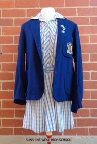 Sunshine and District Historical Society Incorporated
School Uniform, Blazer - Mark Anttony Schoolwear, SUNSHINE WEST HIGH SCHOOL, 1960's
Sunshine West High School started in 1960 with classes held in the old church and the church hall of St Mark's Anglican Church, Sunshine, Victoria, 3020. The school transferred to Lachlan Road, West Sunshine when the new building was completed. In 1961 the proportion of students from European background was almost 52% and those of British-Australian almost 48%. By 1965 the number of students totalled 699, with 28 of them being the first to do the Form 6 (Year 12) Matriculation exam. By 1969 the number of students had increased to the point that some classes were held in shelter sheds. In 1992 the multi campus Sunshine College was formed through the amalgamation and restructure of six schools: Sunshine West High School, Sunshine Technical School, Ardeer High School, North Sunshine Technical School, Sunshine High School, and Tottenham Technical School. The last two school sites were closed and are now occupied by Victoria University and the Tottenham English Language Centre respectively. Sunshine West High School became the junior West Campus of Sunshine College. The style of school uniform displayed here is not used by the Sunshine College. The girls had two sets of uniforms, one for the summer and one for the winter. The frock and blazer (as displayed) were for the summer but a grey straw hat, grey socks, and black shoes were also part of the compulsory uniform. The displayed grey v-necked jumper could be worn in both summer and winter. The winter outfit consisted of a blue shirt, a tie (as displayed), a grey box pleated tunic, blazer, grey stockings, black shoes, a blue felt hat and grey gloves. Of particular interest is that the boys did not have to wear the feminine looking style of grey jumper with the pink and blue stripes. They wore a dark blue jumper. There was a 'uniform inspection' carried out after the Monday morning assembly and the Prefects had the task of policing students to make sure that they wore the full complement of items, both to and from school. The 3 badges indicate that the female student was a member of the School Council, which had replaced the Prefects around 1969 or 1970, and she was also Captain of one of the 4 Sports Houses and of her Form. Sources of information: (1) http://www.sunshine.vic.edu.au/history.htm (accessed 4/11/2015). (2) Book - 'Harvester City' by Olwen Ford (page 412). (3) Discussions with two former students.Sunshine West High School played a significant part in the secondary education of local children, however the school had a relatively short life span in its own right during the latter part of the twentieth century. The items of girls school uniform, the school insignia, and the 3 metal badges serve as a historical reminder of the previous existence of the school, and of the colours and designs of these items.Four items of girls school uniform plus 3 metal badges: (1) Dark blue blazer with school insignia on the left breast pocket. (2) Blue and white striped frock. (3) Light grey v-necked jumper with dark blue, light blue, and pink stripes around the neck and the cuffs. (4) Dark blue tie with light blue and pink diagonal stripes. The 3 badges are School Captain, House Captain, and Form Captain.Insignia on blazer - SWHS / COURAGE AND WISDOMsunshine west high school, girls school uniform, carland, blazer, frock, school jumper, swhs, courage and wisdom, junior campus, west campus, sunshine college, 1960, 1991 -
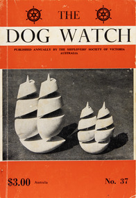 Mission to Seafarers Victoria
Journal (item) - Periodicals-Annual, Shiplovers' Society of Victoria, The Annual Dog Watch
This journal provides the reader with glimpses of the adventures and hardships of a seaman's life. Many of the stories are of sailing ships.Contributes to our knowledge of the importance of shipping and places on record those stories of the sea which would otherwise be lost.Contents Foreword - Senator G. S. Davidson- 5 Editorial - C. E. Bonwick 11 1980 The Goldon Jubilee Part 1 - - 16 " " Part 2 - - 18 " " Part 3 - - 19 Days in Sail - Captain W. J. Cowling - 23 "Old Man River" - I. Harris - 32 Present State and Prospects of the Port Phillip District of New South Wales - Charles Griffiths - 37 Hoboes of the Sea - Captain F. Klebingat - 42 The Stateships Story - N. S. Smith - 46 "Down at Wallaroo" - D. M. Fyfe - 54 Characters - R. N. Thiele - 58 The Lauriston from Newcastle to Tal Tal - R. W. Rudd - 64 From Information for Pylgrymes Unto the Holy Lande 1498 - - 68 s.s. "Port Campbell" First Voyage - I. L. Barton - 70 Maritime Inspection in Finland - Captain Eino Koivistoinen - 81 Wool from Genoa - J. M. MacKenzie - 86 "Polly Woodside" -- The Man Who Made it Happen - Captain G. Heyen, M.B.E. - 91 To Trinidad by "Kilmaurs" - Alexander Cameron - 102 "Oodle" - K. Bull - 109 Ship Talk - Guy H. Jennery - 110 A Glimpse of Ships and Men - W. P. Shemmeld - 113 Book Reviews - 120sailing ships, steamships, shipping, seafaring life, shiplovers' society of victoria, dog watch -
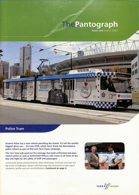 Melbourne Tram Museum
Magazine, Yarra Trams, "The Pantograph", 2007 to 2010
1 - Issue 1 - March 2007 - with photo of the Police Tram (2109) - Welcome message from the CEO Dennis Cliche, Good Friday appeal, Burwood highway works, new sub-stations at Coburg, Royal Park, Brunswick depot, Camberwell depot, East Preston, Essendon, Bundy Clock, Glenhuntly, Kew Depot, Malvern, Southbank,, Safety, events, Lunar Festival .2 - issue 2 - June 2007 - 18 pages, Malvern Depot (a green depot), Paul Matthews profile, trackwork at Glen Huntly and Essendon depots, Depot news, Joyce Barry tribute, Hawthorn depot museum, fund raising. .3 - issue 3 - Octr. 2007 - 16 pages - fund raising - Melbourne city romp, Des Davies retirement, CPR rescue of a collapsed driver, depot news, retirements and a chemical and fire incident on the Vermont South line. .4 - issue 4 - Jan. 2008 - 12 pages - fundraising, family events, depot news, retirements, TramTracker Jake .5 - issue 11 - Winter 2010 - 16 pages - St Kilda Road Superstops, Michel Mason - CEO, Malvern depot centenary, Transformation, new maps on trams, fundraising, the leadership team, depot news, uniforms, South Caulfield Junction upgrade. .6 - 20 pages issue 12, Summer 2010, published soon after Keolis took over operations of Yarra Trams. The first 10 pages, look at Trams on the Fringe, Feedback, Football trams, staff matters, and features a story on page 10 of the Hawthorn Tram Depot museum and Driver Shaun McCarthy wearing the brown uniform in front of tram 1041. Fully Scanned. The second ten pages are reversed (upside down) and titled "Le Pantographer", featuring a Bordeaux tram on the cover. Provides details of Keolis operations such as Lyon, Bordeaux, Lille, Le Mans, Caen, Angers, Dijon and other operations. .7 - issue 6 - Spring 2008 - Meerkats, fleet operations, training, Art Alive, Kew depot - new inspection pits, Long Lay Malvern, Did You Know campaign, and looking for Cricket players - part scanned. .8 - issue 13 - Autumn 2011 - Michel Masson CEO, visit of French Media, Ron Scholten Retirement, photo of Geoff Dean of Camberwell, - part scanned. .9 - issue 5 - June 2008 - Tram works Swanston and Flinders, tram 111, cricket .10 - issue 8 - Autumn 2009 - Good Friday appeal, public transport ombudsman, Malvern centenary, my friend Mike .11 - issue 9 - Spring 2009 - Chris Cairns safety campaign, route 48, Myki, Tramtracker, Jake.Demonstrates Yarra tram staff newslettersEleven issues of Yarra Tram's internal newsletter "The Pantograph", all A4, center stapled. Issues not fully scanned, unless noted.trams, tramways, keolis, yarra trams, fohtd, hawthorn, uniforms, coburg, substation, royal park, burwood highway, fund raising, bundy clock, environment, glenhuntly depot, essendon depot, malvern depot, south caulfield, tram 2109, tram 84, route 48, tram 111, good friday -
 Bendigo Military Museum
Photograph - 4th Field Survey Squadron OC’s Parades and Defence Force Service Medal Presentations, Keswick Barracks, Adelaide SA, 1986
This is a set of 30 photographs of a 4th Field Survey Squadron OC’s parade at Keswick Barracks, Adelaide SA in 1986. The OC - MAJ Don Taylor presented the Defence Force Service Medal to personnel in recognition of 15 years of efficient remunerated service, or the Clasp for 5 years of additional service. This is a set of 30 photographs of a 4th Field Survey Squadron OC’s parade and the presentation of the Defence Force Service Medal, at Keswick Barracks, Adelaide SA in 1986. The colour photographs are on 35mm negative film and are part of the Army Survey Regiment’s Collection. The photographs were scanned at 96 dpi. .1) - Photo, colour, 1986. L to R: WO2 Bob Rogister in background, SPR Bruce Graham, SGT Stu Symonds, SGT Bob Croxton. .2) - Photo, colour, 1986. SGT Bob Croxton. .3) - Photo, colour, 1986. Parade handover L to R: OC MAJ Don Taylor, 2IC CAPT Steve Cooper, unidentified. .4) - Photo, colour, 1986. Inspection L to R: SSM WO1 Bill Griggs, CAPT 2IC Steve Cooper, OC MAJ Don Taylor , unidentified, SSGT Brett ‘Dutchy’ Van Leeuwen, SGT Mick ‘Hoges’ Hogan, SGT Peter Imeson, SGT H. ‘Jock’ Young, PTE Paul Simpson, CPL Neale ‘Tex’ Houston. .5) - Photo, colour, 1986. Inspection L to R: SSM WO1 Bill Griggs, 2IC CAPT Steve Cooper, OC MAJ Don Taylor, PTE Paul Simpson, CPL Neale CPL Neale ‘Tex’ Houston. .6) - Photo, colour, 1986. Presentations L to R: SPR Todd Hayley, SGT Bob Croxton. .7) - Photo, colour, 1986. Presentations L to R: OC MAJ Don Taylor, SGT Bob Croxton. In background L to R: SSM WO1 Bill Griggs, SPR Todd Hayley. .8) - Photo, colour, 1986. Presentations: SGT Bob Croxton. In background: CPL Dave Irving. .9) - Photo, colour, 1986. Presentations L to R: SPR Simon Reynolds, 2IC CAPT Steve Cooper, OC MAJ Don Taylor, SGT Stu Symonds. In background: SSM WO1 Bill Griggs. .10) - Photo, colour, 1986. Presentations L to R: OC MAJ Don Taylor, SGT Stu Symonds. In background: SSM WO1 Bill Griggs. .11) - Photo, colour, 1986. Presentations: SGT Stu Symonds. In background L to R: SSM WO1 Bill Griggs, CPL Dave Irving. .12) - Photo, colour, 1986. Presentations: SGT Stu Symonds. In background: CPL Dave Irving. .13) - Photo, colour, 1986. Presentations L to R: SPR Simon Reynolds, OC MAJ Don Taylor, WO2 Gary Warnest. In background L to R: SPR Todd Hayley, CPL Dave Irving, remainder unidentified. .14) - Photo, colour, 1986. Presentations L to R: OC MAJ Don Taylor, WO2 Gary Warnest. .15) - Photo, colour, 1986. Presentations: WO2 Gary Warnest. In background: SSM WO1 Bill Griggs. .16) & .17) - Photo, colour, 1986. Presentations: WO2 Gary Warnest. In background: SPR Todd Hayley, CPL Dave Irving, CPL S. Asley. .18) - Photo, colour, 1986. L to R: SGT Stu Symonds, SGT Bob Croxton. .19) - Photo, colour, 1986. L to R: SPR Bruce Graham, SGT Stu Symonds, SGT Bob Croxton. .20) - Photo, colour, 1986. Parade handover L to R: 2IC CAPT Steve Cooper, OC MAJ Don Taylor. .21) - Photo, colour, 1986. Parade handover L to R: 2IC CAPT Steve Cooper, SSM WO1 Bill Griggs. In background L to R: SPR Todd Hayley, CPL Dave Irving. .22) & .23) - Photo, colour, 1986. SGT Bob Croxton. .24) & .25) - Photo, colour, 1986. SGT Stu Symonds. .26) & .27) - Photo, colour, 1986. WO2 Gary Warnest. .28) to .30) - Photo, colour, 1986. L to R: SGT Stu Symonds, WO2 Gary Warnest. SGT Bob Croxton..1P to .30P – There are no personnel identified. ‘1986 Presentations’ annotated on negatives sleeve.royal australian survey corps, rasvy, 4 fd svy sqn -
 Bendigo Historical Society Inc.
Memorabilia - GOLD NUGGET COLLECTION: THE GEM, 1906
The Gem The Poseidon Rush. Tarnagulla, Saturday. Article - The Albury Banner and Wodonga Express (NSW : 1871 - 1938)Friday 8 February 1907 - Page 43 The Poseidon Rush. Tarnagulla, Saturday. Several indicators and quartz leaders on the Woolshed Hill have received considerable attention during the last fortnight. In some claims the stone looks very promising, and nice tracings of gold have been obtained. Wragg Brothers struck it rich yesterday. At a depth of 12ft. on the bedrock they discovered a nugget specimen 206oz. in weight, which has been christened the 'Port Arthur. The party also had the good fortune to find two other specimens close, by, one weighing 23oz. 15dwt. and the other 24oz.These were named 'The Twins,' the Wragg Brothers bearing that distinction. In this claim about eight weeks ago the Gem (88oz.) was unearthed. THE POSEIDON RUSH. Article Illustrated - Leader (Melbourne, Vic. : 1862 - 1918, 1935)Saturday 29 December 1906 - Page 33 THE POSEIDON RUSH. It is only about five weeks since this rush was opened by John Porter, but since that time a marvellous change has taken place. The quietness of the bush has given place to a scene of wild excitement, and each week this is intensified by the discovery of large nuggets. When Smith, Rogers and Stephenson picked out their slug on election day, no one dreamed that larger ones were lying only a few feet away, but such was the fact. On Tuesday afternoon two immense slugs, one of which weighed 960 oz., and the other 373 oz., were found in adjoining claims within a few minutes of each other. The finding of these created a scene which it is difficult to describe. "I've got one, “was shouted from the claim of Bert Williamson and T. Stephenson, two men just entering into manhood. They were seen excitedly digging round a lump of gold, one of them with a double-ended pick, the point-of which he broke in his anxiety to unearth it. This slug is nine inches long by seven inches by 43 inches, and is very similar in appearance and size to the big nugget got previously in the adjoining claim. It has been cleaned and smelted, and has yielded 306 oz. of pure gold of the best sample. Before the excitement caused by the discovery of the last nugget had sub-sided, there was a shout from an adjoining claim. Sam Woodall, a Llanelly miner, felt his pick strike a hard yielding sub-stance, and, satisfied that he had struck a nugget, called the attention of his mates to the fact. He soon levered it out of the ground with his pick. Taking it up in his arms he staggered out of the claim with it, and in a minute or two was sur-rounded by hundreds of men who rushed from all over the field to view it, and to feel its weight. It was certainly a magnificent specimen, and the fortunate miners were congratulated on all sides. Its weight was guessed to be a hundredweight, and probably in its then dirty state it would nave turned the scales at that. In a few minutes the crowd was so dense that it was impossible to get a close inspection. The nugget was first taken to Newbridge under escort, then through Llanelly to Tarnagulla, where it was lodged in the Union Bank. It was found that the bank scales were not sufficiently large to weigh the mass. By tying a number of large weights together, and suspending them from a steel bar, a fairly accurate weight was obtained, and it just balanced 80 lb., or 960 oz. The nugget measures 16 in. x 10 in. x 5 in. The party was cheered as it drove up the main street here, and the sight of an armed escort was quite a novelty. The nugget was held aloft in a tin dish for inspection by the crowd. These nuggets were found in the shallow workings, and neither of them were a foot under the surface. The ground is a black loamy soil; there was no appearance of wash whatever, and no one knowing anything of alluvial mining would think of searching for gold in such a spot. All those who have claims on the hillside are breaking out all the dirt in a face from the surface to the reef, which is a mixture of lime and sunstone, and searching for nuggets. The ground is carefully pulverised so that nothing shall be missed. Some are puddling the whole of it, but it is hardly payable. Where the big nuggets are now being found, the ground has been pegged out and abandoned more than once since the rush started, and shares in the claims have been purchased for small amounts. Smith was given a third share in the claim where the first nugget was found for puddling the dirt big lump was discovered, by Woodall, Condron, Brooks and Eva, two of them sold a sixth share for £5 a few days ago to a man named Woods, who only worked a few days and sold out again for 50/. Some fancy prices are now being offered for shares in the claims in the vicinity. Woodall holds a third share, Condron and Brooks three-quarters of a share each, and Eva a sixth share. The largest nugget has been christened "The Poseidon." The names given to the other nuggets obtained previously are as follow: — Wragg Bros., 88 oz. nugget, "The Gem"; Smith and party's 378 oz. nugget, which was unearthed on election day, has been fittingly named "The Federal"; Jackson and Hughes 152 oz.specimen, "The Little. Beu"; Williamson and Stephenson's 373 oz. nugget is said to be called "The Christmas Box." A representative from the (Mines department has been at the bank during, the week taking models for the museums and schools of mines. )A replica of the "Gem" gold nugget that was discovered on 29.11.1906 on the Poseidon Lead at Tarnagulla at the depth of 9 feet. Found on the bedrock by the Wragge Bros. Weight 88 ozs. Value of $126,358 in 2016. (See additional Research.)mining, models, plaster model of victorian gold nugget -
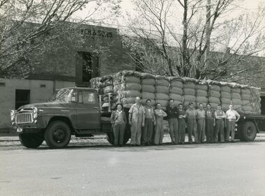 National Wool Museum
Photograph - C. Glover and Sons Pty. Ltd, 1890-1944
C. Glover and Sons Pty. Ltd. was founded on Brougham Street, Geelong c.1870. They operated as a wool and sheepskin storeroom situated on both sides of Brougham Street; where the current Elders building is located. The store was owned and operated by Joshua Glover with his brother Cyrus. A third brother Arthur also worked at the store. It was a very successful business and employed up to 40 men at its peak. Cyrus Glover died quite young, around 54, with his son Howard taking his place in the partnership at 23. During the Second World War the business was requisitioned by the Australian Government. Their wool was utilised to produce defence uniforms for Commonwealth personnel C. Glover and Sons was a very successful business which reluctantly closed its doors around 1975, as a result of the wool industry taking a downward turn Australia wide. It was decided by the family that this was the only option at the time. Howard Glover was Jan Glover’s (donor) father in law. Jan Glover donated these images to the National Wool Museum in 2021. Image 1 is a black and white image of a truck with 11 men standing in front. The truck is loaded with dumped bales of wool. The image is taken outside of the C. Glover and Sons' building. The reverse of the image is stamped. Image 2 is a black and white image of 2 rows of men. The first row of six men are sitting in their cricket whites. The second row of 10 men are standing in suits bar one-man 3rd from the right, who is also in his cricket whites. The image is taken on a cricket oval with the grandstand visible in the background. Image 3 is a black and white image of 12 men. The first 3 men are sitting on wool bales while the other 9 stand behind. The image shows the word 'record' spray painted on a piece of timber hanging behind the man. This is expressed in the men's faces with emotions of joy and celebration coming through. The men are standing in front of large machinery presumed to be used for wool pressing/dumping. Image 4 is a black and white image of 15 men and 5 horses in front of two large white sheds with triangular rooves. The men are all standing with the majority having their arms crossed. On the left is a cart carrying sheep skins. On the right are two smaller carts that appear to be carrying wool bales. Image 5 is a black and white image of a wool and hides storeroom. The ceiling is lined with multiple sheep skins while the floor has multiple wool bales neatly stored. In the background of the image, two men can be seen inspecting wool while sitting at a small white table. Behind this, 5 men are standing in a crowd while another man is seen to the left of the men at the table. This separate man is standing inspecting a wool bale. Image 6 is a black and white image of a wool storeroom. Numerous bales of wool can be seen open for inspection stacked semi-neatly one next to another. 6 men can be seen inspecting a bale of wool in a group. Another 5 men are present in the room performing separate duties.Image 1 Reverse. Black Stamp INTERNATION FOTO-NEWS / H. A SOETEKOUW / 52 GHERINGHAP ST., / GEELONG / PHONE X 2920 Image 2 Wording. Typed black lettering. Geelong Buyers and Brokers Cricket Team. Image 3 Wording. Blue handwriting RECORD OF PRESSING FOR ONE DAY / FORTY BALES / 1910 Image 4 Wording. Blue handwriting. 1890 Image 5 Wording. Typed black lettering. Messrs. Moss & R. Allan. / Government Sheepskin Appraisers. 1918. Image 6 Wording. Black Handwriting. C. GLOVER & SONS. APPRAISEMENT NO. 50 14/12/1944. / GOVERNMENT SHEEPSKIN APPRAISERS. MESSERS. R. BORLAND & H. V. McCALLUM / GEELONG REPRESENTATIVES. J. GLOVER & H. J. GLOVER. c. glover and sons pty. ltd, geelong 1870, brougham street, wool & sheepskin storeroom -
 Moorabbin Air Museum
Manual (item) - Embraer - EMB 110 Aircraft Bandeirante - Collection of manuals See under "Description" Section
-
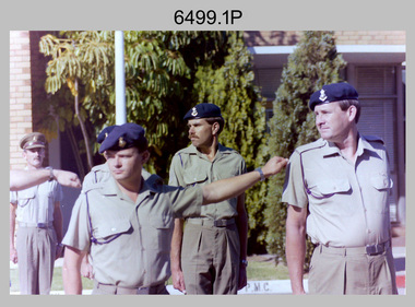
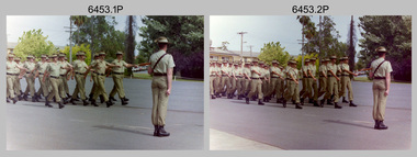
 Bendigo Military Museum
Photograph - Army Survey Regiment – Commanding Officer Handover Parade, Fortuna, Bendigo, 1980
This photograph was taken at a Commanding Officer Handover Parade at the Army Survey Regiment, Bendigo in 1980. LTCOL Bob Skitch was the CO from 1976 to 1980 and handed over LTCOL Frank Thorogood SB St J. LTCOL Thorogood’s appointment was from 1980 to 1981.This is a set of 45 photographs taken at a Commanding Officer Handover Parade at the Army Survey Regiment, Bendigo in 1980. The photographs are on 35mm negative film and were scanned at 96 dpi. Photograph .34P is an enlargement printed on photographic paper and scanned at 300 dpi. They are part of the Army Survey Regiment’s Collection. .1) - Photo, black & white, 1980. Led by HQ Squadron, Army Survey Regiment marches onto the parade ground. .2) - Photo, black & white, 1980. Army Survey Regiment marches onto the parade ground. Drummers L to R: SSGT George Austen, CPL Di Chalmer, CPL Tony Lawler. .3) - Photo, black & white, 1980. Air Survey Squadron formed up. SSM WO1 Bob Mason at front. L to R: unidentified (x9), SPR Kristin (Isaac) Skidmore, unidentified, SPR Scheryl Delforce, unidentified (x2), SSGT Russell ‘Rusty’ Williams, SSGT Peter Warwick, SSGT Greg Buckenham, SGT Cliff Webb, SSGT Alan Derby, SSGT John Bennett, SSGT Bruce Gordon. .4) - Photo, black & white, 1980. Officers formed up before taking posts. L to R: CAPT Peter Searle - UK Exchange, unidentified, LT Ozzy Slade, CAPT Peter ‘Blue’ Blaskett, unidentified (x4), CAPT Bob Williams, MAJ David Bowen - US Exchange officer, unidentified (x3), RSM WO1 Aub Harvey. .5) - Photo, black & white, 1980. Officers salute before taking posts. L to R: CAPT Peter Searle - UK Exchange, unidentified, LT Ozzy Slade, CAPT Peter ‘Blue’ Blaskett, unidentified (x4), CAPT Bob Williams, MAJ David Bowen - US Exchange officer, unidentified (x3). .6) - Photo, black & white, 1980. Officers march to their posts. L to R: CAPT Bob Cooper, CAPT Mick Byrne, MAJ Robin Blackburn, unidentified. .7) & .8) - Photo, black & white, 1980. L to R: 2IC MAJ Don Swiney MBE hands over parade to CO LTCOL Bob Skitch. Cartographic Squadron - Centre rank L to R: CPL Paul Richards, SPR Megan (McBurney) Reynolds, SPR Jan (Crighton) Minchin, SPR Ilen Isaac, CPL Lynn Johnson, remainder unidentified. Front rank L to R: CPL Dennis Learmonth, CPL Roger Pearson, SPR Rod Skidmore, SPR John Martin, SGT Bob Bright, CPL Trevor Bottomley, SPR Gerry Gates, remainder unidentified, OC CAPT Bob Williams, Officer in far right: CAPT Bob Cooper. .9) - Photo, black & white, 1980. L to R: CO LTCOL Bob Skitch salutes reviewing officer - Commander 3MD BRIG Geoffrey Cohen AM. Cartographic Squadron in background L to R: CPL Trevor Bottomley, SPR Gerry Gates, SPR Peter Main, CPL John ‘Stormy’ Tempest, unidentified, OC CAPT Bob Williams, SSGT Gary Warnest. .10) - Photo, black & white, 1980. HQ Squadron inspection - L to R: unidentified (x5), CAPT Paddy Strunks, SPR Chris Ebeling, CO LTCOL Bob Skitch, BRIG Geoffrey Cohen AM, unidentified (x7), in foreground MAJ David Bowen - US Exchange officer, unidentified, CPL Phil McGuire, WO2 Ted Burgess. .11) - Photo, black & white, 1980. HQ Squadron in foreground L to R: MAJ David Bowen - US Exchange officer, unidentified, CPL Phil McGuire, WO2 Ted Burgess. Lithographic Squadron inspection L to R: CPL Paul Davis, CPL Le-Anne (Smallshaw) Shirely, CO LTCOL Bob Skitch, unidentified, OC MAJ Robin Blackburn, BRIG Geoffrey Cohen AM, SPR Jim Ash, unidentified, unidentified UK Exchange SNCO, SSGT Greg Francis-Wright, WO1 Doug Malligan, drummers SSGT George Austen, CPL Di Chalmer, CPL Tony Lawler, unidentified (x2). .12) - Photo, black & white, 1980. Air Survey Squadron inspection - L to R: LT Ozzy Slade, CAPT Peter ‘Blue’ Blaskett, unidentified officer, front rank L to R: SGT Cliff Webb, CO LTCOL Bob Skitch, CAPT Peter Searle - UK Exchange, unidentified, centre rank L to R: unidentified, SSGT Greg Buckingham, SSGT John Bennett, rear rank L to R: unidentified (x4), SPR Sharon (Jones) Treble, CPL Marrianne (Van De Zee) De Groot, SPR Ginny (Turner) Rowe, SSGT Kevin Kennedy, unidentified, SSGT Alan Derby. .13) - Photo, black & white, 1980. Air Survey Squadron inspection - Centre rank: SSGT John Bennett, CO LTCOL Bob Skitch, CAPT Peter Searle - UK Exchange, BRIG Geoffrey Cohen AM, rear rank L to R: SPR Ginny (Turner) Rowe, SSGT Kevin Kennedy, unidentified, SSGT Alan Derby, SSGT Bruce Gordon, supernumerary rank L to R: SSM WO1 Bob Mason, WO1 Bob Hayden, WO2 Peter Colwell, WO1 Chris Parkinson. Unidentified. .14) - Photo, black & white, 1980. Air Survey Squadron inspection - Centre rank: SSGT John Bennett, CO LTCOL Bob Skitch, CAPT Peter Searle - UK Exchange, BRIG Geoffrey Cohen AM, rear rank L to R: SPR Ginny (Turner) Rowe, SSGT Kevin Kennedy, unidentified, SSGT Alan Derby, SSGT Bruce Gordon, supernumerary rank L to R: SSM WO1 Bob Mason, WO1 Bob Hayden, WO2 Peter Colwell. .15) - Photo, black & white, 1980. Cartographic Squadron inspection – L to R: OC CAPT Bob Williams, CO LTCOL Bob Skitch, BRIG Geoffrey Cohen AM. Front rank L to R: CPL John ‘Stormy’ Tempest, unidentified (x2), SSGT Allan Adsett, SSGT Gary Warnest. Centre rank L to R: SPR Ilen Isaac, CPL Sue (Fryer) Bottomley, SPR Gina (Coore) Neilson, SPR Carla Dell, CPL Lynn Johnson, SPR Cathy Regan, unidentified, SSGT John ‘JB’ Barrie, SSGT Bob Scaddan. Rear rank L to R: CPL Terry Danger, CPL Brad Peppler. .16) & .17) - Photo, black & white, 1980. Cartographic Squadron inspection – L to R: OC CAPT Bob Williams, CO LTCOL Bob Skitch, BRIG Geoffrey Cohen AM. Front rank L to R: CPL Dennis Learmonth, CPL Roger Pearson, SPR Rod Skidmore, SPR John Martin, SGT Bob Bright, CPL Trevor Bottomley, SPR Gerry Gates, CPL John ‘Stormy’ Tempest, unidentified (x2), SSGT Allan Adsett, SSGT Gary Warnest. CO LTCOL Bob Skitch, CAPT Bob Cooper, BRIG Geoffrey Cohen AM. Centre rank L to R: SPR Ilen Isaac, CPL Sue (Fryer) Bottomley, SPR Gina (Coore) Neilson, SPR Carla Dell, SPR Cathy Regan, SSGT John ‘JB’ Barrie, SSGT Bob Scaddan. Rear rank L to R: CPL Terry Danger, CPL Brad Peppler, SGT Stu Thaxter, SGT Colin Cuskelly, SGT Bill Friswell. Far right: CAPT Peter Searle - UK Exchange, WO1 Jim ‘JJJ’ Jefferies. .18) - Photo, black & white, 1980. Cartographic Squadron inspection – Front rank: SSGT Gary Warnest. L to R: CO LTCOL Bob Skitch, CAPT Bob Cooper, BRIG Geoffrey Cohen AM. Centre rank L to R: SPR Ilen Isaac, CPL Sue (Fryer) Bottomley, SPR Gina (Coore) Neilson, SPR Carla Dell, SPR Cathy Regan, SSGT John ‘JB’ Barrie, SSGT Bob Scaddan. Rear rank L to R: CPL Terry Danger, CPL Brad Peppler, SGT Stu Thaxter, SGT Colin Cuskelly, SGT Bill Friswell. SSM WO1 Gordon Lowery. Far right: WO1 Jim ‘JJJ’ Jefferies, CAPT Peter Searle - UK Exchange, CAPT Peter ‘Blue’ Blaskett, LT Ozzy Slade. .19) - Photo, black & white, 1980. Medal presentation - L to R: CO LTCOL Bob Skitch, CAPT Bob Cooper. Cartographic Squadron – Front rank L to R: CPL Dennis Learmonth, CPL Roger Pearson, SPR Rod Skidmore, SGT Bob Bright, CPL Trevor Bottomley, SPR Gerry Gates, SPR Peter Main, CPL John ‘Stormy’ Tempest. Centre rank L to R: CPL Paul Richards, SPR Jan (Crighton) Minchin, SPR Ilen Isaac, SPR Carla Dell, CPL Lynn Johnson, SPR Cathy Regan. .20) - Photo, black & white, 1980. Medal presentation - L to R: CAPT Bob Cooper, BRIG Geoffrey Cohen AM. Cartographic Squadron – Front rank L to R: CPL Dennis Learmonth, CPL Roger Pearson, SPR Rod Skidmore, SPR John Martin, SGT Bob Bright, SPR Peter Main, CPL John ‘Stormy’ Tempest, SSGT Allan Adsett, SSGT Gary Warnest. Centre rank L to R: CPL Paul Richards, SPR Jan (Crighton) Minchin, SPR Ilen Isaac, CPL Sue (Fryer) Bottomley, SPR Gina (Coore) Neilson. .21) - Photo, black & white, 1980. Medal presentation - L to R: CAPT Bob Cooper, BRIG Geoffrey Cohen AM. Cartographic Squadron – Front rank L to R: CPL Dennis Learmonth, CPL Roger Pearson, SPR Rod Skidmore, SPR John Martin, SGT Bob Bright, SPR Peter Main, CPL John ‘Stormy’ Tempest, SSGT Gary Warnest. Centre rank L to R: CPL Paul Richards, SPR Jan (Crighton) Minchin, SPR Ilen Isaac, CPL Sue (Fryer) Bottomley. .22) - Photo, black & white, 1980. Medal presentation - L to R: CO LTCOL Bob Skitch, CAPT Bob Cooper, BRIG Geoffrey Cohen AM. Cartographic Squadron – Front rank L to R: CPL Dennis Learmonth, CPL Roger Pearson, SPR Rod Skidmore, SPR John Martin, SGT Bob Bright CPL Trevor Bottomley, SPR Gerry Gates, SPR Peter Main, CPL John ‘Stormy’ Tempest, CAPT Bob Williams, SSGT Allan Adsett. Centre rank L to R: CPL Paul Richards, SPR Jan (Crighton) Minchin, SPR Gina (Coore) Neilson, SPR Carla Dell, CPL Lynn Johnson, SPR Cathy Regan, unidentified, SSGT Bob Scaddan. Rear rank: CPL Stu Symonds. .23) - Photo, black & white, 1980. Presentation - L to R: CO LTCOL Bob Skitch, BRIG Geoffrey Cohen AM, ADJT CAPT John Harrison. Cartographic Squadron – Front rank L to R: CPL Dennis Learmonth, CPL Roger Pearson, SPR Rod Skidmore, SPR John Martin, SGT Bob Bright CPL Trevor Bottomley, SPR Gerry Gates, unidentified, CAPT Bob Williams, SSGT Allan Adsett, CAPT Bob Cooper. Centre rank L to R: SPR Jan (Crighton) Minchin, CPL Sue (Fryer) Bottomley, SPR Carla Dell, CPL Lynn Johnson, SPR Cathy Regan, unidentified, SSGT Bob Scaddan. .24) - Photo, black & white, 1980. Presentation - L to R: CO LTCOL Bob Skitch, BRIG Geoffrey Cohen AM, ADJT CAPT John Harrison. Cartographic Squadron – Front rank L to R: SPR Rod Skidmore, SPR John Martin, SGT Bob Bright CPL Trevor Bottomley, SPR Gerry Gates, unidentified, CAPT Bob Williams, CAPT Bob Cooper. Centre rank L to R: SPR Jan (Crighton) Minchin, CPL Sue (Fryer) Bottomley, SPR Carla Dell, CPL Lynn Johnson, SPR Cathy Regan, unidentified, SSGT Bob Scaddan. .25) - Photo, black & white, 1980. Presentation - L to R: CO LTCOL Bob Skitch, BRIG Geoffrey Cohen AM, ADJT CAPT John Harrison. Cartographic Squadron – Front rank L to R: CPL Roger Pearson, SPR Rod Skidmore, SPR John Martin, SGT Bob Bright CPL Trevor Bottomley, unidentified, CAPT Bob Williams, SSGT Allan Adsett, SSGT Gary Warnest. CAPT Bob Cooper, Centre rank L to R: CPL Sue (Fryer) Bottomley, SPR Gina (Coore) Neilson, SPR Carla Dell, CPL Lynn Johnson. .26) to .28) - Photo, black & white, 1980. Presentation - L to R: MAJ Robin Blackburn, BRIG Geoffrey Cohen AM, ADJT CAPT John Harrison. .29) to .31) - Photo, black & white, 1980. Presentation - L to R: SPR Penny Knott, CO LTCOL Bob Skitch. .32) - Photo, black & white, 1980. CO Handover - L to R: LTCOL Bob Skitch, LTCOL Frank Thorogood SB St J. Cartographic Squadron – Front rank L to R: CPL Dennis Learmonth, CPL Roger Pearson, SPR Rod Skidmore, SPR John Martin SPR Gerry Gates, SPR Peter Main, CPL John ‘Stormy’ Tempest, unidentified, CAPT Bob Williams, SSGT Allan Adsett, SSGT Gary Warnest. Centre rank L to R: SPR Ilan Isaac, CPL Sue (Fryer) Bottomley, SPR Gina (Coore) Neilson, SSGT Bob Scaddan at end. .33) & .34) - Photo, black & white, 1980. CO Handover - L to R: LTCOL Bob Skitch, LTCOL Frank Thorogood SB St J. Cartographic Squadron – Front rank L to R: CPL Dennis Learmonth, CPL Roger Pearson, SPR Rod Skidmore, SPR John Martin, SGT Bob Bright, SPR Gerry Gates, SPR Peter Main, CPL John ‘Stormy’ Tempest, unidentified, CAPT Bob Williams, SSGT Allan Adsett. Centre rank L to R: SPR Ilen Isaac, CPL Sue (Fryer) Bottomley, SPR Gina (Coore) Neilson, SSGT Bob Scaddan at end. .35) - Photo, black & white, 1980. CO Handover – March past L to R: BRIG Geoffrey Cohen AM, ADJT CAPT John Harrison. LTCOL Frank Thorogood SB St J, CO LTCOL Bob Skitch. L to R: RSM WO1 Aub Harvey, 2IC MAJ Don Swiney MBE. .36) - Photo, black & white, 1980. CO Handover March past L to R: BRIG Geoffrey Cohen AM, ADJT CAPT John Harrison. LTCOL Frank Thorogood SB St J, CO LTCOL Bob Skitch. HQ Squadron march past L to R: unidentified officer, MAJ MAJ David Bowen - US Exchange officer, CAPT Paddy Strunks. .37) - Photo, black & white, 1980. CO Handover March past L to R: BRIG Geoffrey Cohen AM, ADJT CAPT John Harrison. LTCOL Frank Thorogood SB St J, CO LTCOL Bob Skitch. HQ Squadron march past L to R: unidentified, SGT Rick Warren, remainder unidentified. .38) - Photo, black & white, 1980. CO Handover March past L to R: BRIG Geoffrey Cohen AM, ADJT CAPT John Harrison. LTCOL Frank Thorogood SB St J, CO LTCOL Bob Skitch. Cartographic Squadron march past L to R: CLP Paul Richards, CPL Dennis Learmonth, CAPT Bob Williams, CAPT Bob Cooper. .39) - Photo, black & white, 1980. CO Handover March past L to R: BRIG Geoffrey Cohen AM, ADJT CAPT John Harrison. LTCOL Frank Thorogood SB St J, CO LTCOL Bob Skitch. Cartographic Squadron march past L to R: SPR Greg Else, SPR Jan (Crighton) Minchin, SPR Rod Skidmore, unidentified, SPR Megan (McBurney) Reynolds, CPL Roger Pearson, CPL Stu Symonds, CPL Paul Richards. .40) - Photo, black & white, 1980. CO Handover March past L to R: BRIG Geoffrey Cohen AM, ADJT CAPT John Harrison. LTCOL Frank Thorogood SB St J, CO LTCOL Bob Skitch. Cartographic Squadron march past L to R: CPL Terry Danger, CPL Lynn Johnson, SPR Peter Main, unidentified, SPR Carla Dell, SPR Gerry Gates, SPR Bob Sheppard, SPR Gina (Coore) Neilson, CPL Trevor Bottomley, SPR Ian Fitzgerald, CPL Sue (Fryer) Bottomley, unidentified. .41) - Photo, black & white, 1980. CO Handover March past L to R: BRIG Geoffrey Cohen AM, ADJT CAPT John Harrison. LTCOL Frank Thorogood SB St J, CO LTCOL Bob Skitch. Lithographic Squadron march past L to R: CAPT Mick Byrne, MAJ Robin Blackburn. .42) - Photo, black & white, 1980. CO Handover March past L to R: BRIG Geoffrey Cohen AM, ADJT CAPT John Harrison. LTCOL Frank Thorogood SB St J, CO LTCOL Bob Skitch. Lithographic Squadron march past L to R: CPL Gary Kerr, SPR Brian Paul, SPR Brian Fauth, CPL Roy Hicks, SPR Per Andersen, CAPT Mick Byrne. .43) & .44) - Photo, black & white, 1980. CO Handover March past L to R: BRIG Geoffrey Cohen AM, ADJT CAPT John Harrison. LTCOL Frank Thorogood SB St J, CO LTCOL Bob Skitch. Lithographic Squadron march past. .45) - Photo, black & white, 1980. CO Handover March past L to R: BRIG Geoffrey Cohen AM, ADJT CAPT John Harrison. LTCOL Frank Thorogood SB St J, CO LTCOL Bob Skitch. Officer march past L to R: unidentified, CAPT Peter Searle - UK Exchange.No personnel are identified. Photo .34P is annotated on back ‘1981 LTCOL Bob Skitch handed over to LTCOL Thorogood.’ *Date is incorrect.royal australian survey corps, rasvy, army survey regiment, army svy regt, fortuna, asr -
 Federation University Historical Collection
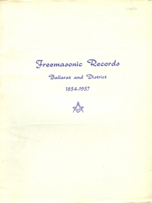
Booklet - Book, Albert Steane, Freemasonic Records Ballarat and District 1854 - 1957, 16/10/1957 (exact)
Born at the Victorian town of Sandhurst (now Bendigo, Albert Steane attended the Gravel Hill State School until the fourth class, then transferred to the Central School 1976 where he gained the Merit Certificate. The monitor system of teacher training had been introduced and he passed as a fourth, third, second and first class pupil teacher. At about 16 years of age Steane was appointed a teacher monitor at £12 per annum. Albert Steane was awarded the Teachers' Certificate of Competency in 1897. He was the first headmaster of the Ballarat Technical School, and opened the Sloyd (woodwork) Centre in 1902 at the Ballarat East Art School (later known as the Ballarat East Free Library). According to the Ballarat Courier of 23 March 1957 Steane established the Ballarat Junior Technical School in February 1913, a part of the School of Mines and Industries Ballarat. The beginning classes with 86 pupils were held at a temporary site at the Dana Street School. Classrooms were so scattered that Steane recalled without his motorbike he would never have covered the ground! By 9 September 1921 the Junior Technical School Building was officially opened on the site of the old Ballarat Gaol. In a confidential report of 1916 Steane was described as one of the best organizers in schools at that time, and he was noted for his strong but fair discipline. In the 1926 school report the Chief Inspector wrote that 'no boy is neglected'. Steane held the position of headmaster at the Ballarat Junior Technical School for 29 years retiring on 16 April 1942. Steane is known for the teaching of Sloyd or woodwork, which was an important point in his career, and for his love of gymnastics. He was made a life member of the Ballarat Y.M.C.A. in 1968 aged 91 years. The teaching of woodwork in Victoria began in 1901 and Steane was chosen, among 18 others for the inaugural training course at Queensberry State School in Melbourne. Because of his lifelong love of gymnastics Steane organized a gymnastic display for the Education Department in 1902 at Bendigo's Golden Jubilee Exhibition. He was one of those instrumental in establishing the Ballarat Y.M.C.A. and directed its physical culture evening classes in 1906. In 1908 Steane toured the world visiting the Swedish Naas Institute and the Gymnastic Festival in Germany. Steane in his reminiscences recalls: "In 1908 I obtained leave of absence and undertook a world trip to further my knowledge of both manual art training and physical training. On this trip I visited U.S.A., Canada, Scotland, England and Europe. Notable events were the attendance at the great 11th Deutche Turnfest at Frankfurt, inspection of the Naas Training School for Sloyd at Naas, Sweden inorgorated [sic] by Otto Solomon, and attendance at Physical Education Demonstrations at London given by the Swedish institution. These P.E. demonstrations were given to assist the organization and introduction of P.E. training in London schools.On returning to Ballarat I resumed my position at the Ballarat East Sloyd Centre and continued my studies at the Ballarat Art School gaining the Drawing Teachers' Certificate." Steane died, aged 93 years, on 13 July 1970, at Sydney, leaving his widow Grace Elliott Steane and children Eric and Violet. Steane is listed on the University of Ballarat Honour Roll at https://www.ballarat.edu.au/curator/honour-roll/honourroll_steane.shtml Printed green book with soft cover. The book lists all masonic bodies, including lodges and chapters, that have worked within 30 miles of Ballarat during the first 100 years of Freemasonry in the district. Includes a Loose, one page addenda et Corrigenda.The image of Albert Steane in the front of the book is inscribed "Yours faithfully A.W. Steane."ballarat, freemason, freemasonic, lodge, albert steane, a a w steane, a j dean, mark lodges, royal ark mariners, royal arch chapters, masonic orders -
 Moorabbin Air Museum
Document (item) - John Porter Estate Collection, John Porter Estate Collection See Description for contents
-
 Wodonga & District Historical Society Inc
Album - Hume Reservoir Australia Album - Detail plan and explanation, Department of Public Works, N.S.W, 1927
This set of photos is from a leather bound album bearing the inscription "HUME RESERVOIR AUSTRALIA" plus 'The Rt. Hon. L. C. M. S. Amery, P. C., M .P.' all inscribed in gold. It was presented to The Rt. Hon. L. C. M. S. Amery, P. C., M. P, Secretary of State for Dominion Affairs on the occasion of his visit to the Hume Reservoir on 2nd November 1927. This album is of local and national significance as it documents the planning and development of the Hume Reservoir up to 1927. It was the largest water reservoir in the British Empire. The album records the pioneering engineering work that went into its construction.2. Detail Plan and Section. Starting from the New South Wales and there will be an earthen embankment 430 feet 6 inches long which is retained by the North Wing Wall. Then come the sluice section 284 feet 3 inches long, the spillway 720 feet long and the South Wing Wall, making a total length of 1,042 feet 6 inches of concrete wall. Beyond the South Wing Wall is earth embankment again to a length of 3,827 feet. The Full Supply Level is R.L.626.00 and allowance has been made for a surcharge of 9 feet. A road will run along the top of the dam at R.L.642.00. The sluice section contains seven offlets, the three nearest the north wing wall being 13 feet in diameter for hydro-electric purposes and the other four 9 feet in diameter for regulation purposes only. There are to be stony sluice gates on the upstream ends of the outlets and needle valves on the downstream ends. The shock of the discharged water will be taken by a stilling pool. Trash racks will protect the intake ends of the outlets. Next comes the spillway section, which is curved on the downstream face, and carried up to within 15 feet of the full supply level. Above that will be a series of piers between which will be the flood gates and on top of which the roadway will be carried. The gates will be 20 feet wide and 15 feet high and will be 29 in number. They will slide down the face of the wall when opened for the escape of the water. The investigation of the control of this cascade of water was made by means of a model and as a result the form of “bucket” or energy dissipater shown on the section of the spillway was decided upon. The earth embankment in Victoria is being constructed by the State Rivers and Water Supply Commission of Victoria who are the Constructing Authority for that State under the River Murray Waters Agreement. The core of the embankment is of concrete 6 feet wide at the base tapering to 2 feet at the top end and is reinforced with steel rods from the level of the decomposed rock upwards. On the downstream side, at about natural surface level, is a tunnel for drainage and inspection purposes. Above the tunnel is a vertical layer of large stones to drain any seepage to the tunnel. Against the core wall is packed selected material of as impervious a character as can be got locally and beyond that the bank is carefully built up in horizontal layers by means of horses and wheel scoops. The upstream slope is 3-to-1 hardening to 2½-to-1 at the top and the downstream slope is 2½-to-1 hardening to 2.07-to-1 at the top. The thrust of the upstream toe is taken by a mass of granite blocks, and this face is protected by concrete laid in situ. The width of the bank at base is 650 feet and at top 32 feet.hume reservoir australia, river murray waters scheme, hume weir diagrams, hume plan details -
 Eltham District Historical Society Inc
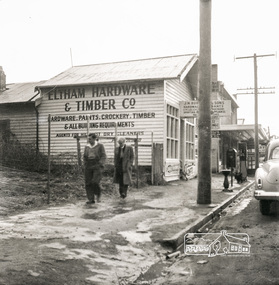
Photograph, Eltham Hardware and Timber Co, Main Road, Eltham, opposite Railway Station. c.1952, 1952c
The Eltham Hardware and Timber Company first opened on Main Road opposite the Railway Station around late 1922. An advertisement placed in the Hurstbridge Advertiser advised that the Hardware Store had just opened with a varied stock of Saws, Hammers, Nails, Shovels, Screw Drivers, and every article required in a house or on a farm. People were also encouraged to try their Jams, Pickles, Sauces, Cups and Saucers, etc. A few months later in May 1923, William Walker, a plumber, placed an advertisement wishing to to announce that he had taken over the ELTHAM HARDWARE STORE, and asked for the continued support of the district. He also noted that all kinds of Plumbing work was done. Walker remained the proprietor of the Hardware Store for many years regularly advertising its services and wares up until at least 1941. The trail goes a bit quiet then but he does appear in the 1944 Electoral Roll listed as a Plumber, of Main Street, Eltham. However he is not listed in the 1949 Electoral Roll but his son, Thomas Roy Walker, also a plumber of Main Road is listed. Thomas had been on active duty overseas during the Second World War and returned at the end of 1945. It is assumed that William died sometime between 1945 and 1949. On November 18th, 1950 the Hardware Store and residence was auctioned on site by Scarff Bros. Pty Ltd. It is presumed that this is when J.N. Burgoyne and Sons took over the business. It would have been around this time the picture of the store was taken for only three years later, in October 1953, the business and dwelling was again put up for sale, this time by Trebilcock Bros, in two separate lots. LOT 1. — ELTHAM HARDWARE AND TIMBER CO. Freehold and Property, Plant, Fittings and Business; Plus Stock at Valuation. To be Sold as a Going Concern. THE FREEHOLD PROPERTY Comprises Large Brick and Timber Shop. Well Fitted. Has Good Light. Comfortable 3-Room Dwelling and Detached Bungalow, H.W.S., Phone, Garage and Outbuildings. Situate on Large Allotment, 50 Ft. x 150 Ft. Aprox. THE BUSINESS: Flourishing Hardware and Builders’ Supplies, Crockery, Glassware and Gifts, Dry Cleaning Agency and Petrol Reseller Licence (1 Bowser Installed), Oil Storage. Annual Turnover Aprox. £12,000. Audited Figures Available, Old-established Business Comprehensive Stock is Good, Clean and Saleable (Value Approx. £4000). TERMS: £1000 Deposit, Balance 30 Days. VACANT POSSESSION. LOT 2. — Superb Shop Sites. Adjoining the Above Property. Land 58 Ft. x 150 Ft. (Approx.). Erected on Land Is Old Style 4-r Timber Dwelling, Set Well Back from Footpath. Leaving Ample Apace to erect Shops. Also Small Shop Let as Agent’s Office. To Be Sold Subject to Existing Tenancies, Gross Rentals £106 12/ Per Annum. Terms: £1000 Deposit, Balance 30 days. GENERAL: Eltham Is a Rapidly Developing Area only 12 Miles from G.P.O. Street Frontage of these Two Adjoining Properties Is 108 Feet By Depth of 150 Feet in the Heart of Expanding Shopping Centre, directly Opposite Station Entrance. Full Details and Inspection Available on Application from the Auctioneers: TREBILCOCK BROS. AUCTIONEERS and ESTATE AGENTS, Coincidentally, the Hardware Store was taken over by Richard Phillip Trebilcock, an electrical engineer from Mayona Road, MontmorencyNegative black and white film 120 6x6 formatSingle frameeltham, main road, 1951 chevrolet deluxe, ampol, eltham hardware and timber, j.n. burgoyne and sons, petrol bowser, william walker, richard phillip trebilcock -
 Bendigo Military Museum
Photograph - Officer Commissioning and CO’s Handover Parade, Army Survey Regiment, Fortuna Villa, Bendigo, 1992
This is a set of 28 photographs taken at a CO’s Parade at the Army Survey Regiment, Fortuna, Bendigo in 1992. On this parade WO1 Bill Jones received his commission and by promotion to Captain from CO LTCOL Rene van den Tol. Command of the unit was handed over to LTCOL Rob McHenry. It is probable the commissioning and handover ceremonies occurred on the CO’s Parade. LTCOL Rene van den Tol was CO from 1989 to 1992 and LTCOL Rob McHenry was CO from 1992 to 1993.This is a set of 28 photographs taken at a CO’s Parade at the Army Survey Regiment, Fortuna, Bendigo in 1992. The colour photographs are on 35mm negative film and scanned at 96 dpi. They are part of the Army Survey Regiment’s Collection. .1) - Photo, colour, 1992. Headquarters Squadron marches past RSM WO1 Graham Ragless. .2) - Photo, colour, 1992. Cartographic Squadron marches past RSM WO1 Graham Ragless. L to R: unidentified personnel, WO2 Steve Hansen, CPL Roger Pearson, WO1 Gary Warnest, SSGT Dennis Learmonth, SSGT Greg Else, CPL Ian Bowes, SGT Stuart Symonds. .3) - Photo, colour, 1992. Lithographic Squadron marches past RSM WO1 Graham Ragless. L to R: unidentified personnel, WO1 Steve Egan, LCPL John Bragg, unidentified personnel, WO2 Rob Bogumil, unidentified personnel, SPR Corey Hill. .4) - Photo, colour, 1992. Air Survey Squadron marches past RSM WO1 Graham Ragless. L to R: unidentified personnel, WO1 Allan Hancox, SSGT Wolfgang Thun, unidentified personnel, WO2 Neil ‘Ned’ Kelly, unidentified personnel, SGT Dave Longbottom, SGT Brian Johnson. .5) - Photo, colour, 1992. Cartographic Squadron. L to R: unidentified personnel, SGT Stuart Symonds, CPL Col McInnes, CAPT Mary Anne Martinek in foreground, SPR Jodi Seith, unidentified personnel, SPR Avril (Bray) Lloyd. .6) - Photo, colour, 1992. Air Survey Squadron. L to R: unidentified officer, SSGT Bruce Hammond, SPR Tracy Tillman, SPR Rachel (Stanford) Scott, SPR Paula (Golding) Brinsmead, SGT Graeme Reany, unidentified officer in foreground, unidentified personnel, CPL Steve Coulson. .7) - Photo, colour, 1992. Cartographic Squadron inspection. L to R: RSM WO1 Graham Ragless, unidentified, OC MAJ Graeme Wastell, CO LTCOL Rene van den Tol, unidentified personnel, CPL Col McInnes, SPR Jodi Seith, SPR Avril (Bray) Lloyd. CPL Steve Ellis, SPR Ian Brown, SPR Andrew Lazdovskis. .8) - Photo, colour, 1992. Cartographic Squadron inspection. L to R: OC MAJ Graeme Wastell, CO LTCOL Rene van den Tol, SPR Avril (Bray) Lloyd, CPL Steve Ellis, SPR Ian Brown, SPR Andrew Lazdovskis, SPR Adrian Taylor, unidentified, SPR Mick Knight, SPR Dawn Hoadley, CPL Craig Kellet. .8) to .12) - Photo, colour, 1992. Officer Commissioning Ceremony. L to R: CO LTCOL Rene van den Tol, WO1 Bill Jones promoted to Captain. .13) - Photo, colour, 1992. Officer Commissioning Ceremony. L to R: ADJT CAPT Geoff Ford, RSM WO1 Graham Ragless, CO LTCOL Rene van den Tol, WO1 Bill Jones promoted to Captain. .14) - Photo, colour, 1992. Officer Commissioning Ceremony. WO1 Bill Jones promoted to Captain. .15) - Photo, colour, 1992. Commanding Officer Handover. CO LTCOL Rene van den Tol delivers speech. .16) to .17) - Photo, colour, 1992. Commanding Officer Handover. R to L: CO LTCOL Rene van den Tol hands over to incoming CO LTCOL Rob McHenry. .18) - Photo, colour, 1992. Commanding Officer Handover. L to R: RSM WO1 Graham Ragless, ADJT CAPT Geoff Ford, CO LTCOL Rob McHenry. .19) - Photo, colour, 1992. Commanding Officer Handover. L to R: ADJT CAPT Geoff Ford, RSM WO1 Graham Ragless, CO LTCOL Rob McHenry. .20) - Photo, colour, 1992. Cartographic Squadron marches off parade ground. L to R: OC MAJ Graeme Wastell, unidentified officer, CAPT Greg Oaten, LT Matt Jackson, CAPT Mary Anne Martinek, SPR Mick Knight. .21) & .22) - Photo, colour, 1992. Cartographic Squadron marches off parade ground. .23) - Photo, colour, 1992. Lithographic Squadron marches off parade ground. L to R: OC Bob Coote, unidentified officer, SPR Scott Cameron, unidentified officer, SSGT Russ Mollenhauer, SGT Brian Fauth. .24) - Photo, colour, 1992. Lithographic Squadron marches off parade ground. L to R: LCPL Janet Murray, unidentified, SPR Mick Muzeen, Allison (Ottaway) Wooldrage, SGT Keith Quinton, SGT Frank Lenane, SGT Laurie Justin, SGT Dale Hudson, LCPL John Bragg, unidentified, SGT Kim Reynolds, SPR Corey Hill, SPR Andrew Arman, SPR Ross Anza, WO1 Peter Coombes. .25) - Photo, colour, 1992. Parade guests. L to R: unidentified guests, MAJ Peter Jensen. .26) - Photo, colour, 1992. Parade guests. L to R: unidentified guests, CAPT Doug Arman, unidentified guests. .27) - Photo, colour, 1992. Parade personnel march off. L to R: unidentified, WO2 Ted Burgess, WO1 Ken Slater. .28) - Photo, colour, 1992. Parade personnel. L to R: unidentified, SPR Allan Blake..1P to .28P – There are no annotations.royal australian survey corps, rasvy, army survey regiment, army svy regt, fortuna, asr -
 Eltham District Historical Society Inc
Photograph, Looking north across the Fitzsimons Lane Bridge over Yarra River between Eltham and Templestowe, c.1985, 1985c
Turnoff to Candlebark Park on right. The bridge over the Yarra River was initially opened September 22nd, 1961. Newspaper reports at the time of opening stated it linked Bolton Street, Eltham, with Fitzsimons Lane, Templestowe. In 1955 the Country Roads Board (CRB) produced survey plans that showed proposed land acquisition for the future bridge and road approaches. The 1955 plan shows that it was proposed to connect Fitzsimons Lane with Bolton Street in Eltham by a diagonal road across the river. The road connection would then continue along Bolton Street to Main Road. Prior to construction of the bridge the CRB modified the proposal significantly so that there was a new road parallel with Bolton Street and then curving to join Main Road at what was then its intersection with Old Eltham Road. This involved significantly more land acquisition and altered the pattern of land subdivision through this corridor. Initially the new road was just a single two-way carriageway as it would have required a significant widening of the cutting on the Shire of Eltham side of the river. The road was officially un-named but was known locally as the Eltham-Templestowe Road. The 1966 Melway street directory and other 1960s editions also listed the road as the Eltham-Templestowe Road. In December 1970, Eltham Shire Council, in pursuance of the provisions of the Local Government Act, named it Templestowe Road. The road was renamed Fitzsimons Lane around 1984 in conformity with the section south of the river. In 1991 a new bridge was built to the west of the original bridge. Fitzsimons Lane was widened to four traffic lanes although on the Eltham side this was done within the limits of the existing cutting. NEW BRIDGE STARTS THEM EXPLORING Without any fanfares, Country Roads Board workmen on Friday afternoon put the finishing touches to the approaches, removed the barricades, and let the traffic roll over the new Yarra bridge linking Bolton Street, Eltham, with Fitzsimons Lane, Templestowe. Over the week-end many “bridge watchers” who were making one of their periodic inspections of the progress on the new bridge found to their surprise that they could drive over it, so that people who had gone for a run out to Eltham suddenly found themselves wandering through Templestowe and Doncaster. By Monday the word of the bridge’s opening had got around sufficiently for many regular travellers to the city from Eltham and beyond to vary the monotony by going to town via Templestowe and Kew instead of through Heidelberg. They were surprised at the distances – about 3 ½ miles from Eltham to Templestowe, 6 miles from Eltham Shire hall to the Lower Heidelberg Road-Banksia Street intersection. NEW NEIGHBOURS For people on both sides of the river, the new bridge has turned distant friends into near neighbours. A Greensborough man on Sunday took 35 minutes to reach the home of a friend in East Doncaster, but the return trip over the new bridge took only 17 minutes. It will be some time yet before most people work out the possibilities in shorter and quicker trips form the north-eastern areas to the eastern and south-eastern suburbs. The coming of the warmer months will soon teach many, though the short cuts to Peninsular beaches and eastern suburban drive-ins. And before very long it is likely there will be a Tramways bus running from Templestowe to Eltham station. NEW BRIDGE STARTS THEM EXPLORING (1961, September 27). The Diamond Valley News (News clipping held in SEA_74-1_047) The previously un-named road between Main Road and Yarra River, Eltham South, east of Bolton Street was named Templestowe Road, December 15, 1970 NAMING OF STREETS AND ROADS. (1970, December 15). The Diamond Valley News (News clipping held in SEA_74-2_022)Colour photographinfrastructure, shire of eltham infrastructure, bridge, fitzsimons lane bridge, yarra river, candlebark park, red nose day -
 Eltham District Historical Society Inc
Photograph, Fitzsimons Lane Bridge over Yarra River between Eltham and Templestowe
The bridge over the Yarra River was initially opened September 22nd, 1961. Newspaper reports at the time of opening stated it linked Bolton Street, Eltham, with Fitzsimons Lane, Templestowe. In 1955 the Country Roads Board (CRB) produced survey plans that showed proposed land acquisition for the future bridge and road approaches. The 1955 plan shows that it was proposed to connect Fitzsimons Lane with Bolton Street in Eltham by a diagonal road across the river. The road connection would then continue along Bolton Street to Main Road. Prior to construction of the bridge the CRB modified the proposal significantly so that there was a new road parallel with Bolton Street and then curving to join Main Road at what was then its intersection with Old Eltham Road. This involved significantly more land acquisition and altered the pattern of land subdivision through this corridor. Initially the new road was just a single two-way carriageway as it would have required a significant widening of the cutting on the Shire of Eltham side of the river. The road was officially un-named but was known locally as the Eltham-Templestowe Road. The 1966 Melway street directory and other 1960s editions also listed the road as the Eltham-Templestowe Road. In December 1970, Eltham Shire Council, in pursuance of the provisions of the Local Government Act, named it Templestowe Road. The road was renamed Fitzsimons Lane around 1984 in conformity with the section south of the river. In 1991 a new bridge was built to the west of the original bridge. Fitzsimons Lane was widened to four traffic lanes although on the Eltham side this was done within the limits of the existing cutting. NEW BRIDGE STARTS THEM EXPLORING Without any fanfares, Country Roads Board workmen on Friday afternoon put the finishing touches to the approaches, removed the barricades, and let the traffic roll over the new Yarra bridge linking Bolton Street, Eltham, with Fitzsimons Lane, Templestowe. Over the week-end many “bridge watchers” who were making one of their periodic inspections of the progress on the new bridge found to their surprise that they could drive over it, so that people who had gone for a run out to Eltham suddenly found themselves wandering through Templestowe and Doncaster. By Monday the word of the bridge’s opening had got around sufficiently for many regular travellers to the city from Eltham and beyond to vary the monotony by going to town via Templestowe and Kew instead of through Heidelberg. They were surprised at the distances – about 3 ½ miles from Eltham to Templestowe, 6 miles from Eltham Shire hall to the Lower Heidelberg Road-Banksia Street intersection. NEW NEIGHBOURS For people on both sides of the river, the new bridge has turned distant friends into near neighbours. A Greensborough man on Sunday took 35 minutes to reach the home of a friend in East Doncaster, but the return trip over the new bridge took only 17 minutes. It will be some time yet before most people work out the possibilities in shorter and quicker trips form the north-eastern areas to the eastern and south-eastern suburbs. The coming of the warmer months will soon teach many, though the short cuts to Peninsular beaches and eastern suburban drive-ins. And before very long it is likely there will be a Tramways bus running from Templestowe to Eltham station. NEW BRIDGE STARTS THEM EXPLORING (1961, September 27). The Diamond Valley News (News clipping held in SEA_74-1_047) The previously un-named road between Main Road and Yarra River, Eltham South, east of Bolton Street was named Templestowe Road, December 15, 1970 NAMING OF STREETS AND ROADS. (1970, December 15). The Diamond Valley News (News clipping held in SEA_74-2_022)Black and white photographinfrastructure, shire of eltham infrastructure, bridge, fitzsimons lane bridge, yarra river -
 Eltham District Historical Society Inc
Photograph, Looking south across the Fitzsimons Lane Bridge over Yarra River between Eltham and Templestowe
The bridge over the Yarra River was initially opened September 22nd, 1961. Newspaper reports at the time of opening stated it linked Bolton Street, Eltham, with Fitzsimons Lane, Templestowe. In 1955 the Country Roads Board (CRB) produced survey plans that showed proposed land acquisition for the future bridge and road approaches. The 1955 plan shows that it was proposed to connect Fitzsimons Lane with Bolton Street in Eltham by a diagonal road across the river. The road connection would then continue along Bolton Street to Main Road. Prior to construction of the bridge the CRB modified the proposal significantly so that there was a new road parallel with Bolton Street and then curving to join Main Road at what was then its intersection with Old Eltham Road. This involved significantly more land acquisition and altered the pattern of land subdivision through this corridor. Initially the new road was just a single two-way carriageway as it would have required a significant widening of the cutting on the Shire of Eltham side of the river. The road was officially un-named but was known locally as the Eltham-Templestowe Road. The 1966 Melway street directory and other 1960s editions also listed the road as the Eltham-Templestowe Road. In December 1970, Eltham Shire Council, in pursuance of the provisions of the Local Government Act, named it Templestowe Road. The road was renamed Fitzsimons Lane around 1984 in conformity with the section south of the river. In 1991 a new bridge was built to the west of the original bridge. Fitzsimons Lane was widened to four traffic lanes although on the Eltham side this was done within the limits of the existing cutting. NEW BRIDGE STARTS THEM EXPLORING Without any fanfares, Country Roads Board workmen on Friday afternoon put the finishing touches to the approaches, removed the barricades, and let the traffic roll over the new Yarra bridge linking Bolton Street, Eltham, with Fitzsimons Lane, Templestowe. Over the week-end many “bridge watchers” who were making one of their periodic inspections of the progress on the new bridge found to their surprise that they could drive over it, so that people who had gone for a run out to Eltham suddenly found themselves wandering through Templestowe and Doncaster. By Monday the word of the bridge’s opening had got around sufficiently for many regular travellers to the city from Eltham and beyond to vary the monotony by going to town via Templestowe and Kew instead of through Heidelberg. They were surprised at the distances – about 3 ½ miles from Eltham to Templestowe, 6 miles from Eltham Shire hall to the Lower Heidelberg Road-Banksia Street intersection. NEW NEIGHBOURS For people on both sides of the river, the new bridge has turned distant friends into near neighbours. A Greensborough man on Sunday took 35 minutes to reach the home of a friend in East Doncaster, but the return trip over the new bridge took only 17 minutes. It will be some time yet before most people work out the possibilities in shorter and quicker trips form the north-eastern areas to the eastern and south-eastern suburbs. The coming of the warmer months will soon teach many, though the short cuts to Peninsular beaches and eastern suburban drive-ins. And before very long it is likely there will be a Tramways bus running from Templestowe to Eltham station. NEW BRIDGE STARTS THEM EXPLORING (1961, September 27). The Diamond Valley News (News clipping held in SEA_74-1_047) The previously un-named road between Main Road and Yarra River, Eltham South, east of Bolton Street was named Templestowe Road, December 15, 1970 NAMING OF STREETS AND ROADS. (1970, December 15). The Diamond Valley News (News clipping held in SEA_74-2_022)Black and white photographinfrastructure, shire of eltham infrastructure, bridge, fitzsimons lane bridge, yarra river -
 Eltham District Historical Society Inc
Photograph, Fitzsimons Lane Bridge over Yarra River between Eltham and Templestowe
The bridge over the Yarra River was initially opened September 22nd, 1961. Newspaper reports at the time of opening stated it linked Bolton Street, Eltham, with Fitzsimons Lane, Templestowe. In 1955 the Country Roads Board (CRB) produced survey plans that showed proposed land acquisition for the future bridge and road approaches. The 1955 plan shows that it was proposed to connect Fitzsimons Lane with Bolton Street in Eltham by a diagonal road across the river. The road connection would then continue along Bolton Street to Main Road. Prior to construction of the bridge the CRB modified the proposal significantly so that there was a new road parallel with Bolton Street and then curving to join Main Road at what was then its intersection with Old Eltham Road. This involved significantly more land acquisition and altered the pattern of land subdivision through this corridor. Initially the new road was just a single two-way carriageway as it would have required a significant widening of the cutting on the Shire of Eltham side of the river. The road was officially un-named but was known locally as the Eltham-Templestowe Road. The 1966 Melway street directory and other 1960s editions also listed the road as the Eltham-Templestowe Road. In December 1970, Eltham Shire Council, in pursuance of the provisions of the Local Government Act, named it Templestowe Road. The road was renamed Fitzsimons Lane around 1984 in conformity with the section south of the river. In 1991 a new bridge was built to the west of the original bridge. Fitzsimons Lane was widened to four traffic lanes although on the Eltham side this was done within the limits of the existing cutting. NEW BRIDGE STARTS THEM EXPLORING Without any fanfares, Country Roads Board workmen on Friday afternoon put the finishing touches to the approaches, removed the barricades, and let the traffic roll over the new Yarra bridge linking Bolton Street, Eltham, with Fitzsimons Lane, Templestowe. Over the week-end many “bridge watchers” who were making one of their periodic inspections of the progress on the new bridge found to their surprise that they could drive over it, so that people who had gone for a run out to Eltham suddenly found themselves wandering through Templestowe and Doncaster. By Monday the word of the bridge’s opening had got around sufficiently for many regular travellers to the city from Eltham and beyond to vary the monotony by going to town via Templestowe and Kew instead of through Heidelberg. They were surprised at the distances – about 3 ½ miles from Eltham to Templestowe, 6 miles from Eltham Shire hall to the Lower Heidelberg Road-Banksia Street intersection. NEW NEIGHBOURS For people on both sides of the river, the new bridge has turned distant friends into near neighbours. A Greensborough man on Sunday took 35 minutes to reach the home of a friend in East Doncaster, but the return trip over the new bridge took only 17 minutes. It will be some time yet before most people work out the possibilities in shorter and quicker trips form the north-eastern areas to the eastern and south-eastern suburbs. The coming of the warmer months will soon teach many, though the short cuts to Peninsular beaches and eastern suburban drive-ins. And before very long it is likely there will be a Tramways bus running from Templestowe to Eltham station. NEW BRIDGE STARTS THEM EXPLORING (1961, September 27). The Diamond Valley News (News clipping held in SEA_74-1_047) The previously un-named road between Main Road and Yarra River, Eltham South, east of Bolton Street was named Templestowe Road, December 15, 1970 NAMING OF STREETS AND ROADS. (1970, December 15). The Diamond Valley News (News clipping held in SEA_74-2_022)Black and white photographinfrastructure, shire of eltham infrastructure, bridge, fitzsimons lane bridge, yarra river -
 Eltham District Historical Society Inc
Photograph, Russell Yeoman, Fitzsimons Lane Bridge over Yarra River between Eltham and Templestowe, c.1970, 1970c
The bridge over the Yarra River was initially opened September 22nd, 1961. Newspaper reports at the time of opening stated it linked Bolton Street, Eltham, with Fitzsimons Lane, Templestowe. In 1955 the Country Roads Board (CRB) produced survey plans that showed proposed land acquisition for the future bridge and road approaches. The 1955 plan shows that it was proposed to connect Fitzsimons Lane with Bolton Street in Eltham by a diagonal road across the river. The road connection would then continue along Bolton Street to Main Road. Prior to construction of the bridge the CRB modified the proposal significantly so that there was a new road parallel with Bolton Street and then curving to join Main Road at what was then its intersection with Old Eltham Road. This involved significantly more land acquisition and altered the pattern of land subdivision through this corridor. Initially the new road was just a single two-way carriageway as it would have required a significant widening of the cutting on the Shire of Eltham side of the river. The road was officially un-named but was known locally as the Eltham-Templestowe Road. The 1966 Melway street directory and other 1960s editions also listed the road as the Eltham-Templestowe Road. In December 1970, Eltham Shire Council, in pursuance of the provisions of the Local Government Act, named it Templestowe Road. The road was renamed Fitzsimons Lane around 1984 in conformity with the section south of the river. In 1991 a new bridge was built to the west of the original bridge. Fitzsimons Lane was widened to four traffic lanes although on the Eltham side this was done within the limits of the existing cutting. NEW BRIDGE STARTS THEM EXPLORING Without any fanfares, Country Roads Board workmen on Friday afternoon put the finishing touches to the approaches, removed the barricades, and let the traffic roll over the new Yarra bridge linking Bolton Street, Eltham, with Fitzsimons Lane, Templestowe. Over the week-end many “bridge watchers” who were making one of their periodic inspections of the progress on the new bridge found to their surprise that they could drive over it, so that people who had gone for a run out to Eltham suddenly found themselves wandering through Templestowe and Doncaster. By Monday the word of the bridge’s opening had got around sufficiently for many regular travellers to the city from Eltham and beyond to vary the monotony by going to town via Templestowe and Kew instead of through Heidelberg. They were surprised at the distances – about 3 ½ miles from Eltham to Templestowe, 6 miles from Eltham Shire hall to the Lower Heidelberg Road-Banksia Street intersection. NEW NEIGHBOURS For people on both sides of the river, the new bridge has turned distant friends into near neighbours. A Greensborough man on Sunday took 35 minutes to reach the home of a friend in East Doncaster, but the return trip over the new bridge took only 17 minutes. It will be some time yet before most people work out the possibilities in shorter and quicker trips form the north-eastern areas to the eastern and south-eastern suburbs. The coming of the warmer months will soon teach many, though the short cuts to Peninsular beaches and eastern suburban drive-ins. And before very long it is likely there will be a Tramways bus running from Templestowe to Eltham station. NEW BRIDGE STARTS THEM EXPLORING (1961, September 27). The Diamond Valley News (News clipping held in SEA_74-1_047) The previously un-named road between Main Road and Yarra River, Eltham South, east of Bolton Street was named Templestowe Road, December 15, 1970 NAMING OF STREETS AND ROADS. (1970, December 15). The Diamond Valley News (News clipping held in SEA_74-2_022)Roll of 35mm black and white negative film, 4 of 7 stripsIlford HP4bridge, bridges, fitzsimons lane bridge, infrastructure, shire of eltham infrastructure, yarra river -
 Eltham District Historical Society Inc
Photograph, Fitzsimons Lane Bridge over Yarra River between Eltham and Templestowe, c.1966, 1966c
The bridge over the Yarra River was initially opened September 22nd, 1961. Newspaper reports at the time of opening stated it linked Bolton Street, Eltham, with Fitzsimons Lane, Templestowe. In 1955 the Country Roads Board (CRB) produced survey plans that showed proposed land acquisition for the future bridge and road approaches. The 1955 plan shows that it was proposed to connect Fitzsimons Lane with Bolton Street in Eltham by a diagonal road across the river. The road connection would then continue along Bolton Street to Main Road. Prior to construction of the bridge the CRB modified the proposal significantly so that there was a new road parallel with Bolton Street and then curving to join Main Road at what was then its intersection with Old Eltham Road. This involved significantly more land acquisition and altered the pattern of land subdivision through this corridor. Initially the new road was just a single two-way carriageway as it would have required a significant widening of the cutting on the Shire of Eltham side of the river. The road was officially un-named but was known locally as the Eltham-Templestowe Road. The 1966 Melway street directory and other 1960s editions also listed the road as the Eltham-Templestowe Road. In December 1970, Eltham Shire Council, in pursuance of the provisions of the Local Government Act, named it Templestowe Road. The road was renamed Fitzsimons Lane around 1984 in conformity with the section south of the river. In 1991 a new bridge was built to the west of the original bridge. Fitzsimons Lane was widened to four traffic lanes although on the Eltham side this was done within the limits of the existing cutting. NEW BRIDGE STARTS THEM EXPLORING Without any fanfares, Country Roads Board workmen on Friday afternoon put the finishing touches to the approaches, removed the barricades, and let the traffic roll over the new Yarra bridge linking Bolton Street, Eltham, with Fitzsimons Lane, Templestowe. Over the week-end many “bridge watchers” who were making one of their periodic inspections of the progress on the new bridge found to their surprise that they could drive over it, so that people who had gone for a run out to Eltham suddenly found themselves wandering through Templestowe and Doncaster. By Monday the word of the bridge’s opening had got around sufficiently for many regular travellers to the city from Eltham and beyond to vary the monotony by going to town via Templestowe and Kew instead of through Heidelberg. They were surprised at the distances – about 3 ½ miles from Eltham to Templestowe, 6 miles from Eltham Shire hall to the Lower Heidelberg Road-Banksia Street intersection. NEW NEIGHBOURS For people on both sides of the river, the new bridge has turned distant friends into near neighbours. A Greensborough man on Sunday took 35 minutes to reach the home of a friend in East Doncaster, but the return trip over the new bridge took only 17 minutes. It will be some time yet before most people work out the possibilities in shorter and quicker trips form the north-eastern areas to the eastern and south-eastern suburbs. The coming of the warmer months will soon teach many, though the short cuts to Peninsular beaches and eastern suburban drive-ins. And before very long it is likely there will be a Tramways bus running from Templestowe to Eltham station. NEW BRIDGE STARTS THEM EXPLORING (1961, September 27). The Diamond Valley News (News clipping held in SEA_74-1_047) The previously un-named road between Main Road and Yarra River, Eltham South, east of Bolton Street was named Templestowe Road, December 15, 1970 NAMING OF STREETS AND ROADS. (1970, December 15). The Diamond Valley News (News clipping held in SEA_74-2_022)Black and white photographManufacturer's marks: Polaroid, Batch #J62K181 (Sep 1966).infrastructure, shire of eltham infrastructure, bridge, fitzsimons lane bridge, polaroid, yarra river -
 Eltham District Historical Society Inc
Photograph, Fitzsimons Lane Bridge over Yarra River between Eltham and Templestowe, c.1966, 1966c
The bridge over the Yarra River was initially opened September 22nd, 1961. Newspaper reports at the time of opening stated it linked Bolton Street, Eltham, with Fitzsimons Lane, Templestowe. In 1955 the Country Roads Board (CRB) produced survey plans that showed proposed land acquisition for the future bridge and road approaches. The 1955 plan shows that it was proposed to connect Fitzsimons Lane with Bolton Street in Eltham by a diagonal road across the river. The road connection would then continue along Bolton Street to Main Road. Prior to construction of the bridge the CRB modified the proposal significantly so that there was a new road parallel with Bolton Street and then curving to join Main Road at what was then its intersection with Old Eltham Road. This involved significantly more land acquisition and altered the pattern of land subdivision through this corridor. Initially the new road was just a single two-way carriageway as it would have required a significant widening of the cutting on the Shire of Eltham side of the river. The road was officially un-named but was known locally as the Eltham-Templestowe Road. The 1966 Melway street directory and other 1960s editions also listed the road as the Eltham-Templestowe Road. In December 1970, Eltham Shire Council, in pursuance of the provisions of the Local Government Act, named it Templestowe Road. The road was renamed Fitzsimons Lane around 1984 in conformity with the section south of the river. In 1991 a new bridge was built to the west of the original bridge. Fitzsimons Lane was widened to four traffic lanes although on the Eltham side this was done within the limits of the existing cutting. NEW BRIDGE STARTS THEM EXPLORING Without any fanfares, Country Roads Board workmen on Friday afternoon put the finishing touches to the approaches, removed the barricades, and let the traffic roll over the new Yarra bridge linking Bolton Street, Eltham, with Fitzsimons Lane, Templestowe. Over the week-end many “bridge watchers” who were making one of their periodic inspections of the progress on the new bridge found to their surprise that they could drive over it, so that people who had gone for a run out to Eltham suddenly found themselves wandering through Templestowe and Doncaster. By Monday the word of the bridge’s opening had got around sufficiently for many regular travellers to the city from Eltham and beyond to vary the monotony by going to town via Templestowe and Kew instead of through Heidelberg. They were surprised at the distances – about 3 ½ miles from Eltham to Templestowe, 6 miles from Eltham Shire hall to the Lower Heidelberg Road-Banksia Street intersection. NEW NEIGHBOURS For people on both sides of the river, the new bridge has turned distant friends into near neighbours. A Greensborough man on Sunday took 35 minutes to reach the home of a friend in East Doncaster, but the return trip over the new bridge took only 17 minutes. It will be some time yet before most people work out the possibilities in shorter and quicker trips form the north-eastern areas to the eastern and south-eastern suburbs. The coming of the warmer months will soon teach many, though the short cuts to Peninsular beaches and eastern suburban drive-ins. And before very long it is likely there will be a Tramways bus running from Templestowe to Eltham station. NEW BRIDGE STARTS THEM EXPLORING (1961, September 27). The Diamond Valley News (News clipping held in SEA_74-1_047) The previously un-named road between Main Road and Yarra River, Eltham South, east of Bolton Street was named Templestowe Road, December 15, 1970 NAMING OF STREETS AND ROADS. (1970, December 15). The Diamond Valley News (News clipping held in SEA_74-2_022)Black and white photographManufacturer's marks: Polaroid, Batch #J62K181 (Sep 1966).infrastructure, shire of eltham infrastructure, bridge, fitzsimons lane bridge, polaroid, yarra river