Showing 1505 items
matching bridge street bridge
-
 Eltham District Historical Society Inc
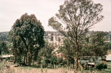
Photograph, Russell Yeoman, Bridge Street looking east from Adam Crescent, Eltham, 1960s, 1960s
... Bridge Street looking east from Adam Crescent, Eltham...bridge street... melbourne streets eltham bridge street adam crescent Russell Yeoman ...Digital file only; created from original colour positive slide transparencystreets, eltham, bridge street, adam crescent, russell yeoman collection -
 Eltham District Historical Society Inc
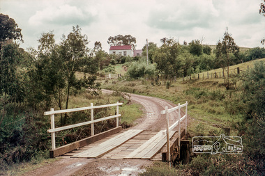
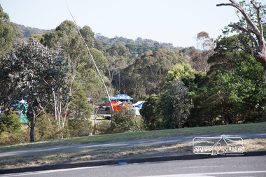
Photograph, Russell Yeoman, Long Gully Road Bridge over Long Gully at Panton Hill, c.1970, 1970c
The house on the hill burnt down in 1977Digital file only; created from original colour positive slide transparencystreets, panton hill, long gully, long gully road, bridge, russell yeoman collection -
 Eltham District Historical Society Inc
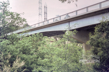
Photograph, Russell Yeoman, Fitzsimons Lane Bridge, c.1970, 1970c
... melbourne New Fitzsimons Lane Bridge prior to duplication streets ...New Fitzsimons Lane Bridge prior to duplicationDigital file only; created from original colour positive slide transparencystreets, eltham, bridge, fitzsimons lane bridge, fitzsimons lane, russell yeoman collection -
 Eltham District Historical Society Inc
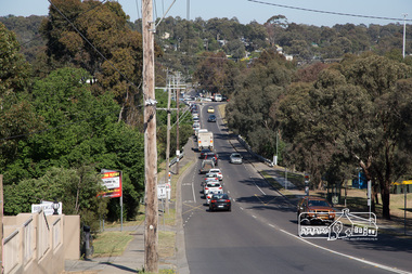
Photograph, Peter Pidgeon, North bound traffic routed down Bridge Street during Bolton Street upgrade, Eltham, 13 November, 2017, 13/11/2017
... North bound traffic routed down Bridge Street during Bolton...Bridge Street...Bridge Street, Eltham, Victoria, Australia... melbourne bolton street upgrade eltham streets Bridge Street Born ...Born Digitalbolton street upgrade, eltham, streets, bridge street -
 Eltham District Historical Society Inc
Photograph, Peter Pidgeon, The last of the marquees from the Eltham Festival being disassembled viewed from Bridge Street during Bolton Street upgrade, Eltham, 13 November, 2017, 13/11/2017
... disassembled viewed from Bridge Street during Bolton Street upgrade...bridge street...Bridge Street, Eltham, Victoria, Australia... melbourne bolton street upgrade eltham streets bridge street Eltham ...Born Digitalbolton street upgrade, eltham, streets, bridge street, eltham festival -
 Eltham District Historical Society Inc
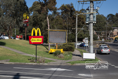
Photograph, Peter Pidgeon, McDonalds Restaurant, cnr Bridge Street and Bolton Street, Eltham, during Bolton Street upgrade, 13 November, 2017, 13/11/2017
... McDonalds Restaurant, cnr Bridge Street and Bolton Street...bridge street...Bridge Street, Eltham, Victoria, Australia... upgrade eltham streets bridge street McDonalds Restaurant Born ...North bound lane closureBorn Digitalbolton street, bolton street upgrade, eltham, streets, bridge street, mcdonalds restaurant -
 Eltham District Historical Society Inc
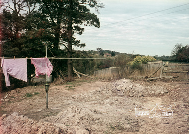
Photograph, Russell Yeoman, 66 Susan Street, Eltham, c.1965, 1965c
... Bridge Street...Bridge Street on left. In 1965 the property was owned... melbourne Bridge Street on left. In 1965 the property was owned ...Bridge Street on left. In 1965 the property was owned by the Shire of Eltham. 66 Susan Street was eventually developed into the Eltham Skate Park in the 1990s and the rest of the property is part of the Alistair Knox Park.Digital file only; created from original colour positive slide transparencyeltham, streets, houses, alistair knox park, eltham skate park, susan street, russell yeoman collection, bridge street -
 Eltham District Historical Society Inc
Photograph, Russell Yeoman, 66 Susan Street, Eltham, c.1965, 1965c
... Bridge Street...Looking southeast from backyard, Bridge Street visible... melbourne Looking southeast from backyard, Bridge Street visible ...Looking southeast from backyard, Bridge Street visible under washing.Digital file only; created from original colour positive slide transparencyeltham, streets, susan street, eltham skate park, alistair knox park, bridge street, russell yeoman collection -
 Eltham District Historical Society Inc
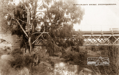
Photograph postcard, River Plenty Bridge, Greensborough
Postcard with view of bluestone bridge over the Plenty River on what is now Main Street, Greensborough. Built in 1860 by a Scottish stonemason, James Neave McKenzie. Most of the bridge was demolished in 1966 with the remaining bluestone arch preserved till 1983 when it was also demolished. This view about 1900.Digital file only Postcards scanned from the collection of Michael Aitken on loan to EDHS, 13 Feb 2018michael aitken collection, postcards, greensborough, plenty river bridge, plenty river -
 Ringwood and District Historical Society
Photograph, Bridge over Mullum Creek under construction, Oliver Street. 1963
... Written on back of photograph, "Bridge over Mullum Creek..., "Bridge over Mullum Creek, Oliver Street. 17/11/1963" 2 ...2 photographsWritten on back of photograph, "Bridge over Mullum Creek, Oliver Street. 17/11/1963" -
 Ringwood and District Historical Society
Photograph, Mullum Creek, 50 yards west of bridge in Ringwood Street Ringwood. May 1971
... Mullum Creek, 50 yards west of bridge in Ringwood Street... of bridge in Ringwood Street Ringwood. May 1971 Photograph ...Writing on back of small photograph reads, "May 1971. Mullum Creek, 50 yards west of bridge in Ringwood St." Enlargement reads, "Mullum Creek looking west from bridge in Ringwood St. July 1972". -
 Orbost & District Historical Society
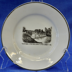
plate
This item is an early souvenir of the local district.Small white plate with black rim. Black and white illustration of the bridge over the Snowy River at Orbost.Back - Made in Orbost. Front - The Bridge Over The Snowy River At Orbost, Vic.plate souvenir snowy-river orbost -
 Orbost & District Historical Society
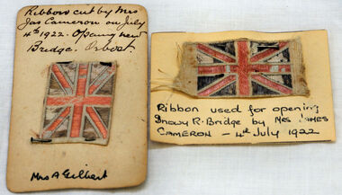
ribbon, 1922
They are both pieces of ribbon used for the opening of the snowy River Bridge on July 4 1922. The ribbon was made to represent the red, white and blue of the British flag. This was the second bridge over the Snowy River. The first bridge was officially opened in August, 1893 (ref. S.R.M. 12.8.1893) by Mrs W. Watt, the mother of Councillor Watt, who presided over the opening of the 1922 bridge. This bridge was extensively damaged when a herd of cattle allegedly stampeded over it causing the cable to snap. Even after repairs it became obvious that a new bridge was needed. This second bridge, was built by the Victorian Railways and the Country Roads Board. Constructed at a cost of 35,000 pounds and used second-hand girders from the Flinders Street- Spencer Street viaduct. On July 4 1922 it was officially opened by Mrs James Cameron. Unfortunately, her husband, who had long championed the building of the bridge so that it would be ready for the railway to continue to the border, was too ill to attend the ceremony. In fact, James Cameron died on July 13 after a long and severe illness (ref. S.R.M. 20.7.1922). Souvenirs kept by enthusiastic spectators like this have helped to preserve the history of an important Orbost event.Two pieces of ribbon in British flag pattern of red, white and blue. These have been pinned onto card with a handwritten description of their history.snowy-river cameron souvenir -
 Orbost & District Historical Society
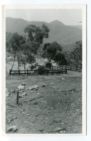
black and white photographs, 1934
These photographs were taken just after the McKillop's Bridge was completed after the flood damage. The current McKillop’s Bridge was built by the Country Roads Board in two stages between 1931-36, during which its height was raised after the original bridge superstructure was washed away in record floods of January 1934, prior to its original official opening. In its reconstructed form the original concrete abutments were turned into additional piers and the welded-steel trusses were cantilevered back over them to meet the new higher road approaches. It is sited at McKillops Crossing, named after pioneer overlanding squatter George McKillop who crossed here in 1835. This was a stock crossing place for almost a century before the bridge was constructed. (info. from Victoria Heritage Register)This is a pictorial record of the history of McKillop's Bridge, in itself of historical significance for its association with Victoria's long and important pastoral history, its technicl significance and aesthetic significance.Three black / white photographs. 3133.1 shows the approach to a washed away bridge. 3133.2 is of a bridge over a river with men clearing debris. 3133.3 is a close-up showing the wreckage of the bridge.mckillop's-bridge snowy-river flood-damage-1934 -
 Orbost & District Historical Society
black and white photograph, mid - second half 20th century
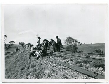
This photograph was taken near the Nicholson River Bridge. The gang re-laying the rail tracks on the Bairnsdale - Orbost line were working in the Bruthen area. In this photograph the men had just finished work near the Nicholson River Bridge.This photograph is associated with the Easy Gippsland Railway.A black / white photograph of a group of men working on a railway line. There is another group behind them.on back - typed information as beloweast-gippsland-railway nicholson-railway railway-construction -
 Orbost & District Historical Society
black and white photograph, mid 1930s
This is a photograph of McKillop's Bridge probably taken just after its rebuilding. The current McKillop’s Bridge was built by the Country Roads Board in two stages between 1931-36, during which its height was raised after the original bridge superstructure was washed away in record floods of January 1934, prior to its original official opening. In its reconstructed form the original concrete abutments were turned into additional piers and the welded-steel trusses were cantilevered back over them to meet the new higher road approaches. "McKillops Bridge was Heritage listed due to its social and technological significance – the steel trusses' arc-welded construction technique was a pretty big deal in the 1930s. It was once an important route for cattlemen, who used the ford across the Snowy in the years preceding the bridge's existence"This is a pictorial record of McKillop's Bridge just after its construction.A black / white photograph of a wooden bridge across a river. At the bottom right is a man with his back to the camera. He is looking at flood debris on the bank. At the bottom left are two men near a pylon.on back - McKillops Bridgebridge-mckillop's snowy-river-bridge -
 Orbost & District Historical Society
May 1900
This is a photograph of the original Orbost / Snowy River Bridge , a suspension bridge which opened in 1893. It has been taken when the Snowy River was in flood. It is similar to other photographs held in The State Library, Victoria. The Snowy River Mail and Tambo and Croajingolong Gazette Sat 12 Aug 1893 records the opening of this bridge as "the most important public event that has yet been commemorated in Eastern ......The Messrs McLeod, with whom the first settlement of this district is generally associated, took up their residence on the eastern bank of the Snowy River about the year 1841 or 42. The late Mr W. Roadknight and Mr T. T. Stirling took possession of the territory on the western side of the Snowy about 35 years ago. During the occupation of the country by cattle owners, very little progress was made in the way of roads and bridges, and except to the hardy and lexperienced bushman, it might have been generally regarded as inaccessible. About the year 1877, however, the late Mr James Robertson eldest son of Mr James Robertson, of Lochend farm, selected land now occupied by his father, about four miles from Orbost on the west bank of the river, Mr John Cameron visited the. district shortly after a .tour of inspection and returned later with his brothers, James and Alick Gameron, but found that during their absence Mr Ernest Watt had found his way on the scene and pegged out a selection, thus anticipating the advent of the Camerons by about 12 hours. We understand that a Mr Kidd, who selected the property now occupied by Mr W. J. Ross, at Pumpkin Point, was one of the earliest batch of settlors.........."This is a pictorial record of an early bridge across the Snowy River at Orbost.A black / white photograph of a suspension bridge with flood waters below the bridge.orbost-bridge suspension-bridge snowy-river -
 Orbost & District Historical Society
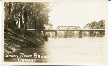
black and white photograph, first half 20th century
This is a photograph of the second Snowy River Bridge at Orbost. The section in the central span could have been built after flood damage. This bridge over the Snowy River was opened on July 4 1922. It was constructed in 1922 alongside the previous suspension bridge. Its building was a combined effort of the Victorian Railways and the Country Roads Board at a cost of 35,000 pounds. It was replaced in 1976 by the present bridge after several major floods.This bridge was replaced in 1976 after several major floods.A black / white photograph / postcard of a bridge over a river. It has what looks like a bo girder in the central section. On the left is the river bank.on front bottom left - "SNOWY RIVER BRIDGE"orbost snowy-river-bridge transport-bridge -
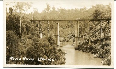 Orbost & District Historical Society
black and white photograph, first half 20th century
This appears to be the Boggy Creek bridge and to have been taken at Nowa Nowa. The Boggy Creek Bridge was built in 1916 as part of the Bairnsdale to Orbost extension to the main Gippsland Railway, and is situated in the middle of the township of Nowa Nowa, crossing a steep-sided and well-timbered creek-valley. This section of the line closed in 1987.This bridge plays a major part in the identity and history of the town of Nowa Nowa, since Boggy Creek’s steep sided valley divides the township into two components. It is part of the East Gippsland Railway line.A black / white photograph / postcard of a tall railway bridge, with concrete pylons in the centre,There is a creek below.on front - bottom left - " NOWA NOWA BRIDGE"boggy-creek-railway-bridge nowa-nowa railway-bridge east-gippsland-railway orbost-bairnsdale-railway -
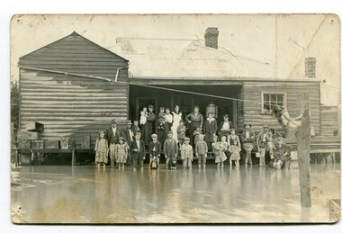 Orbost & District Historical Society
black and white photograph, poss. 1920
In the photograph are the Rice family, Billy Nixon' family and Charlie Johnston. William Nixon, son of James Nixon and Alice (Roberts) Nixon was married to Ilma Muriel (Cadwallader) Nixon on 2 Apr 1902 in Orbost. They had six children - Llewella Adele (Nixon) King, Sydney William Columbo Nixon, Arthur Harry Nixon, Jack Warton Nixon, Claudine Frances (Nixon) Taylor and Daphne Joyce (Nixon) Menz Damage estimated at £500,000 was caused by the 1934 floods in the Orbost district. This 1934 flood was devastating, destroying a section of the 1922 Orbost bridge, wrecking fences, bridges and roads, dumping silt and debris on the rich river flats and drowning cattle. Note: although this card has the date 1934 written onto the rear, the flood incident depicted most likely dates from 1920 (ref. Weekly Times, Saturday 6 March 1920 p 41 when this photo was printed).This item is a pictorial record of a flood in 1920 (ref. Weekly Times, Saturday 6 March 1920 p41). Snowy River flood are a feature of the Orbost area. These floods cover the rich agricultural land. A black / white photograph / postcard of a group of people standing in floodwaters outside a timber building. Included are young children and babies being held by women. Two boys are holding dogs in front of them.on back - "Billy Nixon's house (now Downys 1991)"orbost - floods - nixon - 1920 -
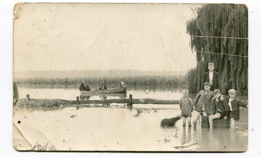 Orbost & District Historical Society
black and white photograph, 1934
This photograph was taken during the flood of 1934 in Orbost. The people in the photograph are related to Billie and Ilma Nixon and Charlie Johnston. Damage estimated at £500,000 was caused by the 1934 floods in the Orbost district. This 1934 flood was devastating, destroying a section of the 1922 Orbost bridge, wrecking fences, bridges and roads, dumping silt and debris on the rich river flats and drowning cattle.This item is a pictorial record of a significant event in Orbost's history. It is associated with local families.A black / white photograph / postcard of floodwaters. On the right is a young man with four young boys sitting on a log. In the bckground is a rowing boat with one man rowing and three others sitting on the edges . A field of maize / corn is in the background and a large willow tree on the right.on back - "M. C. Rice Orbost 19 /1/20 M Gilbert. Mostly Billy Nixons & Charlie Johnstons 1934" [Note alteration: W C Rice rather than M C Rice].floods-orbost-1934 nixon-william johnston-charles -
 Orbost & District Historical Society
black and photograph / postcard, 1.4.1908
This postcard was sent to Annie Gilbert (Mrs John Gilbert) of Tullagoota, Orbost. It was written by "Grace", probably her sister, Grace Cameron Annie Gilbert was the daughter of John Cameron who selected the first land on the Snowy River flats. This is a photograph of the original Orbost / Snowy River Bridge , a suspension bridge which opened in 1893. It has been taken when the Snowy River was in flood. It is similar to other photographs held in The State Library, Victoria. The Snowy River Mail and Tambo and Croajingolong Gazette Sat 12 Aug 1893 records the opening of this bridge as "the most important public event that has yet been commemorated in Eastern ......The Messrs McLeod, with whom the first settlement of this district is generally associated, took up their residence on the eastern bank of the Snowy River about the year 1841 or 42. The late Mr W. Roadknight and Mr T. T. Stirling took possession of the territory on the western side of the Snowy about 35 years ago. During the occupation of the country by cattle owners, very little progress was made in the way of roads and bridges, and except to the hardy and lexperienced bushman, it might have been generally regarded as inaccessible. About the year 1877, however, the late Mr James Robertson eldest son of Mr James Robertson, of Lochend farm, selected land now occupied by his father, about four miles from Orbost on the west bank of the river, Mr John Cameron visited the. district shortly after a .tour of inspection and returned later with his brothers, James and Alick Gameron, but found that during their absence Mr Ernest Watt had found his way on the scene and pegged out a selection, thus anticipating the advent of the Camerons by about 12 hours. We understand that a Mr Kidd, who selected the property now occupied by Mr W. J. Ross, at Pumpkin Point, was one of the earliest batch of settlers.........."This item is associated with Annie Gilbert (nee Cameron) reported to have been the first white girl to be born in Orbost. It is a pictorial record of the suspension bridge over the Snowy River which has since been replaced twice.A faded black / white postcard of a bridge across a river. There are cattle in the river and the banks are tree-covered.on back - a hand-written letter addressed to Mrs J. Gilbert Tullagoota Orbost.cameron-annie suspension-bridge-orbost snowy-river-orbost -
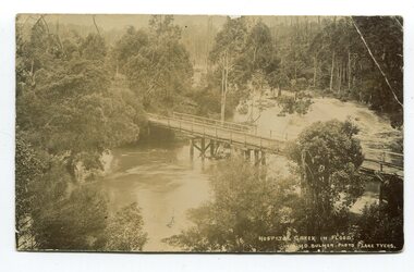 Orbost & District Historical Society
black and white photograph / postcard, Early 20th century - pre 1906?
This photograph shows the Hospital Creek in flood. This is a pictorial record of a bridge in East Gippsland in the early 20th century.A black / white photograph / postcard of a road bridge across a flooded creek. It is in a bush setting.in front at bottom - "Hospital Creek in flood H.D.Bulmer photo Lake Tyers"bridge-hospital-creek tostaree-bridge -
 Orbost & District Historical Society
black and white photographs, 25.11.1976
These photographs were taken on November 25, 1976 at the official opening of the current Snowy River road bridge. Included in the photographs are: John Duggan; Pat Hall, C.R.B. chairman, R.E.V. Donaldson (3240.7) and J.A.Rafferty, the state minister for Transport, who cut the ribbon (3240.8). Di Young and Cheryl Dusting (3240.9) distributed souvenir information pamphlets to official guests. The Snowy River road bridge is one of four built as part of the 8.4 km project spanning the Orbost flood plains. The Snowy River bridge and another over the nearby Ashbys Gulch are among the 10 longest bridges in Victoria, being the eighth and fifth longest respectively. The new bridge removed through traffic from Orbost township crossing the Snowy River 45 m downstream of the old bridge.This bridge is the fourth to provide a crossing to the township of Orbost. (info from CRB NEWS No. 34. DECEMBER, 1976) These photographs are pictorial records of a significant event in Orbost's history.Eleven black / white photographs all related to the official opening of the current Snowy River Bridge. Details are in catalogue folder.snowy-river-bridge -
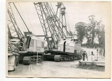 Orbost & District Historical Society
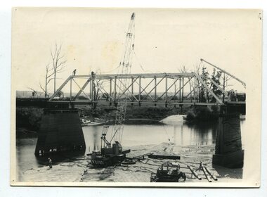
black and white photographs, 1974 - 1976
Construction of the roadway embankment between the bridges across the Snowy River flood plains at Orbost commenced in January 1974 and was completed in November 1976. Pearsons were the bridge contractors for the construction of the Princes Freeway and bridges across the river flood plains at Orbost. Heavy rains and floods held up progress.These photographs are of the construction of a major structure in Orbost. The opening of this Snowy River Bridge was an important development in the accessibility to the township of Orbost.Four black / white photographs of construction sites. 3241.1 is of three cranes and other machinery with six persons. 3241.2 is of workmen working on flooded site. 3241.3 is a photograph of the early stages of construction of a bridge looking towards the township. 3241.4 shows the construction of a roadway between the bridges.construction-snowy-river-bridge bridge-orbost -
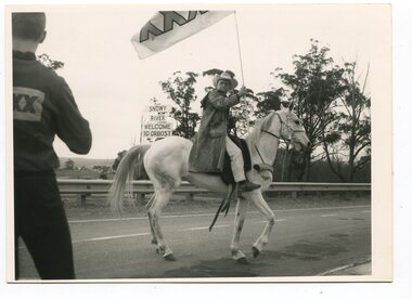 Orbost & District Historical Society
black and white photographs, November 1976
All of these photographs were taken prior to 25th November, 1876, the official opening and crossing of the current Snowy River Bridge. Gary Downey, an Orbost Apeian, did a "De Groot" and crossed the bridge on horseback prior to the official cars crossing the bridge to signal the opening of the new structure. There was a closing ceremony for the old bridge with a group arriving in a 1927 Chrysler, owned by Apexian, Peter Dreverman. This was watched by groups of school students. Some of the Apex members, including Jim Duggan, Noel Smart and Pat Hall, dressed in formal attire to speak to the audience.This event was organised by the Apex Club of Orbost.The Apex Club of Orbost was a volunteer service club which contributed to the Orbost community. A declining population has led to the demise of many social groups in the area.Ten black / white photographs related to the unofficial opening of the Snowy River Bridge at Orbost. snowy-river-bridge-1976 apex-club-orbost ceremony -
 Orbost & District Historical Society
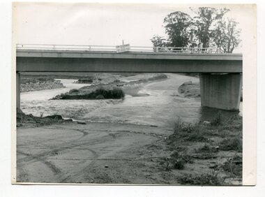
black and white photographs, October 22 1976
The road to Marlo was cut by flood waters from the Snowy River in two places. The road was closed when water flowed over Gilbert's Gulch (3243.1) The Snowy River broke its banks and flooded surrounding Orbost, Marlo, Lochend and Jarrahmond were isolated. The river bank at the bridge site was broken and filled with earth and rock fill. (3243.2) The new Snowy River Bridge was nearing completion when the river rose 7.2 metres causing erosion on the eastern bank. (3243.7) Contractors involved in the construction of the Princes Freeway and bridge were delayed by the flood waters. (3243.8) The 1976 flood at Orbost was a significant event which delayed the construction of the current Snowy River Road Bridge.These photographs record that event.Nine black / white photographs of flood waters across roads. orbost-flood-1976 snowy-river-bridge marlo-road-flood-1976 gilbert;s-gulch-flood -
 Orbost & District Historical Society
black and white photographs, February 17 1971
After the damage from the February 1971 floods at Orbost when the abutment to the Snowy River road bridge was washed away a Bailey bridge, portable, pre-fabricated, truss bridge, was put into place to ensure town access, the C.R.B. rebuilt the approach to the bridge driving new piles and constructing the Bailey bridge. They worked late into the night under flood lights to ensure the link from the Orbost township to the Princes Freeway would be open to traffic as soon as possible.These photographs are pictorial records of a significant event in the history of Orbost.Three black / white photographs of a Bailey bridge being erected across a river. 3245.1 and 3245.2 are the same. bailey-bridge orbost-snowy-river-bridge bridge-orbost -
 Orbost & District Historical Society
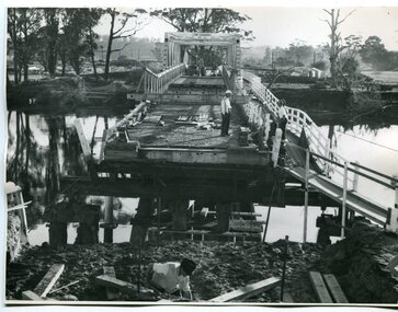
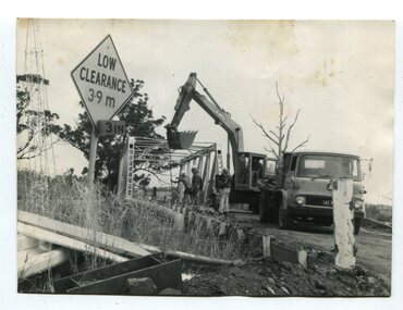
black and white photographs, 1976 - 1977
These photographs are of the demolition of the road bridge across the Snowy River at Orbost. This bridge over the Snowy River was opened on July 4 1922. It was constructed in 1922 alongside the previous suspension bridge. Its building was a combined effort of the Victorian Railways and the Country Roads Board at a cost of 35,000 pounds. It was replaced in 1976 by the present bridge after several major floods.This bridge was replaced in 1976 after several major floods. These photographs are pictorial records of its demolition.Four black / white photographs of the demolition of a road bridge across a river. In them can be seen trucks, excavators and workmen. In 3246.1 there is a triangular road sign - "LOW CLEARANCE 3.9m"bridge-demolition orbost-snwoy-river-bridge -
 Orbost & District Historical Society
black and white photographs, 1977
This is a series of photographs of the demolition of the 1922 bridge across the Snowy River at Orbost. This bridge over the Snowy River was opened on July 4 1922. It was constructed in 1922 alongside the previous suspension bridge. Its building was a combined effort of the Victorian Railways and the Country Roads Board at a cost of 35,000 pounds. It was replaced in 1976 by the present bridge after several major floods.This bridge was replaced in 1976 after several major floods. These photographs record the demolition of that bridge.Ten black / white photographs of a road bridge demolition. In the photographs are cranes, one on a barge, and workmenon back - Orbost Snowy River Bridge demolition 1977