Showing 1577 items matching "shopping centre"
-
 Ringwood and District Historical Society
Letter, Ringwood Bowling Club wanting loan of wire fencing until the hedges grow in 1930
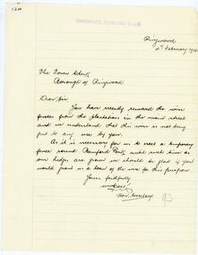
... initially located on the land now occupied by the Eastland Shopping... by the Eastland Shopping Centre. It moved to its current location ...1929 saw the establishment of the Ringwood Bowls Club initially located on the land now occupied by the Eastland Shopping Centre. It moved to its current location in Loughnan Road, Ringwood in 1997.Two lettersRingwood Bowling Club wanting loan of wire fencing until the hedges grow in February 1930city of ringwood bowls club, ringwood bowling club, ringwood bowls club, lawn bowls, bowling -
 Ringwood and District Historical Society
Letter, JK McCaskill objecting to the Bowling Club using further public reserve land
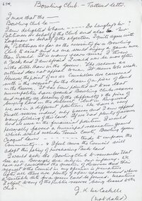
... initially located on the land now occupied by the Eastland Shopping... by the Eastland Shopping Centre. It moved to its current location ...1929 saw the establishment of the Ringwood Bowls Club initially located on the land now occupied by the Eastland Shopping Centre. It moved to its current location in Loughnan Road, Ringwood in 1997.JK McCaskill objecting to the Bowling Club using further public reserve land. Undated.city of ringwood bowls club, ringwood bowling club, ringwood bowls club, lawn bowls, bowling -
 Ringwood and District Historical Society
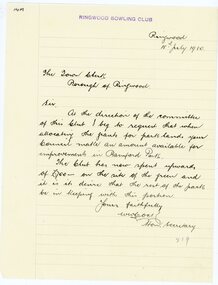
Letter, Ringwood Bowling Club asking the council for a grant for improvements to Bamford Park in 1930
... initially located on the land now occupied by the Eastland Shopping... by the Eastland Shopping Centre. It moved to its current location ...1929 saw the establishment of the Ringwood Bowls Club initially located on the land now occupied by the Eastland Shopping Centre. It moved to its current location in Loughnan Road, Ringwood in 1997.Ringwood Bowling Club asking the council for a grant for improvements to Bamford Park in July 1930.city of ringwood bowls club, ringwood bowling club, ringwood bowls club, lawn bowls, bowling -
 Ringwood and District Historical Society
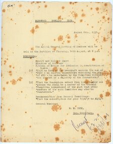
Document, Ringwood Bowling Club notices for the Annual General Meetings in August 1930, 1931 and 1932
... initially located on the land now occupied by the Eastland Shopping... by the Eastland Shopping Centre. It moved to its current location ...1929 saw the establishment of the Ringwood Bowls Club initially located on the land now occupied by the Eastland Shopping Centre. It moved to its current location in Loughnan Road, Ringwood in 1997.Ringwood Bowling Club notices (3) for the Annual General Meetings on 14th August 1930, 18th August 1931 and 1st August 1932 at the Pavilioncity of ringwood bowls club, ringwood bowling club, ringwood bowls club, lawn bowls, bowling -
 Ringwood and District Historical Society
Letter, Ringwood Bowling Club asking the council for further support to provide shrubs and flowers for Bamford Park and the bowling green area in 1931
... initially located on the land now occupied by the Eastland Shopping... by the Eastland Shopping Centre. It moved to its current location ...1929 saw the establishment of the Ringwood Bowls Club initially located on the land now occupied by the Eastland Shopping Centre. It moved to its current location in Loughnan Road, Ringwood in 1997.Ringwood Bowling Club asking the council for further support to provide shrubs and flowers for Bamford Park and the bowling green area in 1931. Also letter of thanks for 12 pounds, six weeks later.city of ringwood bowls club, ringwood bowling club, ringwood bowls club, lawn bowls, bowling -
 Ringwood and District Historical Society
Letter, Ringwood Bowling Club thanking the Mayor and councillors for the many favours given to the Bowling Club, written in 1936
... initially located on the land now occupied by the Eastland Shopping... by the Eastland Shopping Centre. It moved to its current location ...1929 saw the establishment of the Ringwood Bowls Club initially located on the land now occupied by the Eastland Shopping Centre. It moved to its current location in Loughnan Road, Ringwood in 1997.Ringwood Bowling Club thanking the Mayor and councillors for the many favours given to the Bowling Club, written in 1936city of ringwood bowls club, ringwood bowling club, ringwood bowls club, lawn bowls, bowling -
 Ringwood and District Historical Society
Letter, Borough of Ringwood engineer stating that a road between Warrandyte Road and Adelaide St has been completed in 1931
... initially located on the land now occupied by the Eastland Shopping... by the Eastland Shopping Centre. It moved to its current location ...1929 saw the establishment of the Ringwood Bowls Club initially located on the land now occupied by the Eastland Shopping Centre. It moved to its current location in Loughnan Road, Ringwood in 1997.Borough of Ringwood engineer stating that a road between Warrandyte Road and Adelaide St has been completed in 1931. The proposed name of Bamford Grove.city of ringwood bowls club, ringwood bowling club, ringwood bowls club, lawn bowls, bowling -
 Sunbury Family History and Heritage Society Inc.
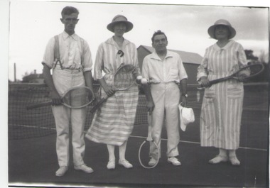
Photograph, c 1920s
... by then Sunbury Shopping Centre adjacent to the railway line.... by then Sunbury Shopping Centre adjacent to the railway line. Tennis ...The four people had gathered to play a tennis match of the courts which were sited in Evans Street, which is now occupied by then Sunbury Shopping Centre adjacent to the railway line.A black and white photograph of two ladies and two men standing in front of a net on a tennis court.tennis, tennis courts -
 Ringwood and District Historical Society
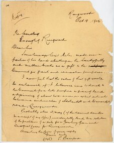
Letter, From Philip Bamford to Borough of Ringwood gifting a parcel of land for park and recreation purposes
... initially located on the land now occupied by the Eastland Shopping... initially located on the land now occupied by the Eastland Shopping ...1929 saw the establishment of the Ringwood Bowls Club initially located on the land now occupied by the Eastland Shopping Centre. It moved to its current location in Loughnan Road, Ringwood in 1997.Hand-written letter from Philip Bamford to To Borough of Ringwood's Town Clerk giving a parcel of land for park and recreation purposes. Probable site for bowling green and croquet lawn. The land would adjoin similar donation from Capt Miles [Miles Park]. Dated 18th October 1926.city of ringwood bowls club, ringwood bowling club, ringwood bowls club, lawn bowls, bowling -
 Surrey Hills Historical Society Collection
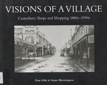
Book, Visions of a Village : Canterbury shops and shopping 1880s-1990s, 1995
... in the shopping and service centre of Canterbury and Maling Roads... in the shopping and service centre of Canterbury and Maling Roads... and activities that took place in the shopping and service centre ...Focussing on the growth and activities that took place in the shopping and service centre of Canterbury and Maling Roads in Canterbury from the 1880s to the present, it is partly a guide book to the present buildings of the centre through the streetscapes and brief lives of each of the premises.Focussing on the growth and activities that took place in the shopping and service centre of Canterbury and Maling Roads in Canterbury from the 1880s to the present, it is partly a guide book to the present buildings of the centre through the streetscapes and brief lives of each of the premises. illus. of streetscapes, indexshops, canterbury, maling road, (mr) george robinson, rochester road, j weymouth, railways, m white, hindson buildings, (mrs) - hillier, f g wilson, s huckerby, g cox, (mr) george cornell, lawson brothers, retail trade, commercial development -
 Surrey Hills Historical Society Collection
Book, Visions of a Village : Canterbury shops and shopping 1880s-1990s, 1995
... in the shopping and service centre of Canterbury and Maling Roads... in the shopping and service centre of Canterbury and Maling Roads... and activities that took place in the shopping and service centre ...Focussing on the growth and activities that took place in the shopping and service centre of Canterbury and Maling Roads in Canterbury from the 1880s to the present, it is partly a guide book to the present buildings of the centre through the streetscapes and brief lives of each of the premises.Focussing on the growth and activities that took place in the shopping and service centre of Canterbury and Maling Roads in Canterbury from the 1880s to the present, it is partly a guide book to the present buildings of the centre through the streetscapes and brief lives of each of the premises. illus. of streetscapes, indexshops, canterbury, maling road, (mr) george robinson, rochester road, j weymouth, railways, m white, hindson buildings, (mrs) - hillier, f g wilson, s huckerby, g cox, (mr) george cornell, lawson brothers, retail trade, commercial development -
 Greensborough Historical Society
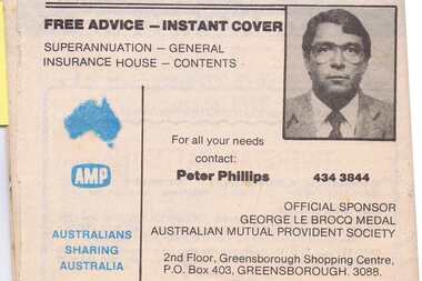
Advertisement - Digital Image, AMP 1985, 20/07/1985
... ) of Greensborough Shopping Centre, representative Peter Phillips. Copied... Mutual Provident Society) of Greensborough Shopping Centre ...Advertisement for AMP (Australian Mutual Provident Society) of Greensborough Shopping Centre, representative Peter Phillips. Copied from a Diamond Valley Football League football record from 1985. I Digital copy of advertisement from booklet.diamond valley football league, australian mutual provident society amp, peter phillips -
 Sunbury Family History and Heritage Society Inc.
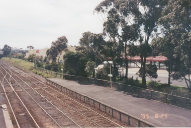
Photograph, 25th July 1995
... shopping centre buildings and the bus terminal which... and is looking north to take in the Sunbury Square shopping centre ...The photograph of Sunbury Station was taken from the pedestrian bridge and is looking north to take in the Sunbury Square shopping centre buildings and the bus terminal which are on the Platform 1 or east side of the station.During the 1990s much development took place in Sunbury and the station precinct became a commercial hub.A coloured photograph of a railway station and a Coles Supermarket in the middle distance as well as a bus terminal. -
 Melbourne Legacy
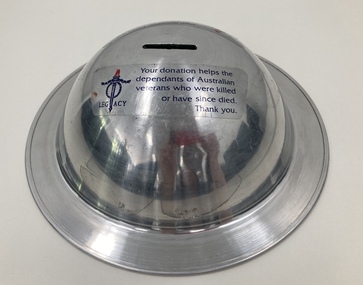
Functional object, Collection Tin
... that it was used is unknown. They could have been left at shopping centres... is unknown. They could have been left at shopping centres or other ...A collection tin in the shape of an army tin hat. Date that it was used is unknown. They could have been left at shopping centres or other public spaces for the general public to donate loose change.A record of a method of fundraising.Round silver collection tin in the shape of an army tin hat.Stickers saying 'Your donation helps the dependants of Australian veterans who were killed or have since died. Thank you'. Underneath a sticker saying 'Property of Legacy' and 'Call the Fundraising Department at Legacy House on 9663 3564 for collection'.fundraising, donations -
 Greensborough Historical Society
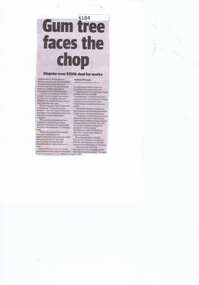
Newspaper Clipping, Diamond valley Leader, Gum tree faces the chop, 07/08/2019
... Shopping Centre.... for the towering gum at Diamond Village Shopping Centre. diamond village ...Neighbours in Watsonia are dismayed a beloved tree faces the chopping block after Banyule Council agreed to accept $150,000 from an architecture firm in exchange for the towering gum at Diamond Village Shopping Centre.News article 1 page, black text.diamond village, gum tree, banyule city council, c kairouz architects -
 Whitehorse Historical Society Inc.
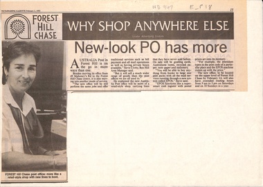
Newspaper - Article, New look post office has more, 2/02/1993
... its office from 49 Mahoneys Road to Forest Hill Chase Shopping... Chase Shopping Centre. It will be a new style post office ...Article in Nunawading Gazette. Australia Post has moved its office from 49 Mahoneys Road to Forest Hill Chase Shopping Centre. It will be a new style post office selling cards and Australiana items etc. New system is called EPOS, the cash register has postal prices set in its memory.post offices, forest hill post office, australia post, forest hill chase -
 Melbourne Tram Museum
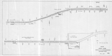
Drawing, Melbourne & Metropolitan Tramways Board (MMTB), "Burwood Highway Warragul Rd to Middleborough Rd - Preliminary Layout", c1975
... , and a track into a proposed shopping centre complex where a bus..., and a track into a proposed shopping centre complex where a bus ...Drawing, folded sheet to A4, titled "Burwood Highway Warragul Rd to Middleborough Rd - Preliminary Layout" showing the proposed layout of the tramway that was later built by the MMTB. Shows track alignment, cross streets, schools, the RSPCA, and a track into a proposed shopping centre complex where a bus interchange was noted. Part of a larger report.trams, tramways, burwood, burwood highway, new tramway, middleborough rd, buses -
 Melbourne Tram Museum
Photograph - Digital Image, Kevin O'Reilly, Sandringham" looking south over the Sandringham Railway station, mid 1920's
... , shopping centre, Tait train in the platform and the beach front..., Sandringham tram depot, shopping centre, Tait train in the platform ...Image from CD (Compact Diskette for use in computers) - see Reg Item 135. Image titled "Sandringham" on CD, of looking south over the Sandringham Railway station, shows the interlocked gates at the level crossing, Sandringham tram depot, shopping centre, Tait train in the platform and the beach front. Mid 1920's?trams, tramways, sandringham, vr trams -
 Greensborough Historical Society
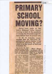
Newspaper Clipping, Primary school moving?, 21/08/1973
... shopping centre close to Greensborough Primary School led to some... occasioned by a new shopping centre close to Greensborough Primary ...Concern about increased traffic occasioned by a new shopping centre close to Greensborough Primary School led to some Councillors suggesting that the Education Department should be asked whether it was considering relocation of the school. [1973]Photocopy of newspaper clipping, black text, laminated.greensborough primary school, greensborough plaza -
 Robin Boyd Foundation
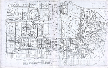
Document, Plan
... ) with home units, housing commission, shopping centre and public...) with home units, housing commission, shopping centre and public ...Plan of Eastlakes development NSW (north of Botany) with home units, housing commission, shopping centre and public reserve between Gardeners RD, Universal Street, Grafton Street, Florence Street and Maloney Street.Photocopy, double page taped on reverse. Handwritten and typewritten. -
 City of Kingston
Photograph - Black and white, c. 1965
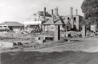
... and was later demolished to make way for Southland Shopping Centre. ... and was later demolished to make way for Southland Shopping Centre ...The St John of God Home for Disadvantaged Boys was located on Nepean Highway Chletenham, and was previously known as the Methodist Children's Home. It opened in approximately 1953 and was later demolished to make way for Southland Shopping Centre. The Brothers of St John of God were a Catholic order that first arrived in Australia in 1947, establishing their first school for boys with learning difficulties. They soon acquired 20 acres in Cheltenham in 1953, which became home to 100 boys and young men who could no longer live with their familiesBlack and white image of a demolition site where the St John of God Home for Disadvantaged Boys once stood. Buildings are visible behind the boys' home site, although also slated for demolition.Black printed text on white round sticker on reverse: 231 Handwritten in red ink on reverse: 95%religion, cheltenham, orphanage, boys home -
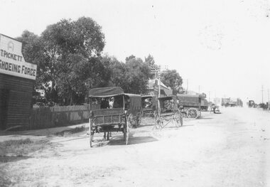
 Ballarat Tramway Museum
Negative, Wal Jack, mid to late 1940's
... hall - this area (2020) is now a car park and major shopping... and major shopping centre area. Photo mid to late 1940's ...Negative and Digital images of the Wal Jack Geelong Negative file of the Geelong 33 in bound to the City and then North at the intersection of Regent and High St Belmont. Tram is picking up passengers. In the background is a school or church hall - this area (2020) is now a car park and major shopping centre area. Photo mid to late 1940's. trams, tramways, geelong, high st, belmont, north, tram 33 -
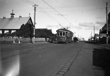
 Ringwood and District Historical Society
Photograph, Outside the Ringwood Market in Maroondah Hwy. 1925
... in Maroondah Hwy. 1925. Shop in centre (is) at corner of Ringwood... the Ringwood Market in Maroondah Hwy. 1925. Shop in centre ...Black and white photograph of street scene showing unmade road with horses and carts at roadsides and wooden buildings to left of photograph. (2 copies)Typed below photograph, "Outside the Ringwood Market in Maroondah Hwy. 1925. Shop in centre (is) at corner of Ringwood Street. ... ". -
 Vision Australia
Photograph - Image, Richard Carbone and Mal Fraser, October 2007
... navigate the escalators at Maribyrnong shopping centre (Highpoint... navigate the escalators at Maribyrnong shopping centre (Highpoint ...Images taken of schoolboy Richard Carbone, who worked with Orientation and Mobility Instructor Malcolm Fraser to successfully navigate the escalators at Maribyrnong shopping centre (Highpoint?) One image reproduced in 2007-8 Annual Report.16 digital images of Richard Carbone and Mal Fraservision australia, richard carbone, malcolm fraser, orientation and mobility -
 City of Kingston
Photograph - Black and white, 20 December 1945
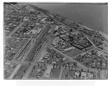
... of the Southland shopping centre in the 1960s and expansion in the 1990s.... of the Southland shopping centre in the 1960s and expansion in the 1990s ...This aerial photograph depicts the changing landscape of Cheltenham and Highett since WWII. Photographed in 1945, there is a mix of urban dwellings and industrial development and precedes the major transformation of Cheltenham with the development of the Southland shopping centre in the 1960s and expansion in the 1990s.A large part of Cheltenham was originally established as a rural market gardening community. The railway line and station brought urban development to the area and in the north, the Highett area was dominated by the Highett Gas Works. Cheltenham became a major destination for shopping in the 1960s with the opening of Southland.Aerial photograph taken in 1945 of Cheltenham and Highett within the City of Kingston. The image includes the Highett Reserve, (top right), the Methodist Children Homes (now Southland), Nepean Highway and Jamieson Street. Highett Gas Works is visible in the top left and the land now named William Fry Reserve at the intersection of Bay Road and Nepean Highway. A visible large parcel of land on the corner of Bay Road and Nepean Highway was developed in the 1990s as the west side addition to Southland. The densely vegetated area in the upper right sector of the image is now dense with housing. Tulip Grove, Heather Grove and Gilford Street are visible bottom left. This image is possibly from the collection of aerial photographs commissioned by the Department of Crown Lands and Survey and taken by Adastra Airways.Black ink: 57252 White lettering: VIC-10 57252 20.12.45 [lens information indecipherable] PROJ. No.5 MELB. METROP AREA Black pencil: 80highett, cheltenham, highett gas works, urbanisation -
 City of Kingston
Photograph - Black and white, 20 December 1945
... of the Southland shopping centre in the 1960s and expansion in the 1990s.... of the Southland shopping centre in the 1960s and expansion in the 1990s ...This aerial photograph depicts the changing landscape of Cheltenham and Highett since WWII. Photographed in 1945, there is a mix of urban dwellings and industrial development and precedes the major transformation of Cheltenham with the development of the Southland shopping centre in the 1960s and expansion in the 1990s.A large part of Cheltenham was originally established as a rural market gardening community. The railway line and station brought urban development to the area and in the north, the Highett area was dominated by the Highett Gas Works. Cheltenham became a major destination for shopping in the 1960s with the opening of Southland.Aerial photograph taken in 1945 of Cheltenham and Highett within the City of Kingston. The image includes the Highett Reserve, (top right), the Methodist Children Homes (now Southland), Nepean Highway and Jamieson Street. Highett Gas Works is visible in the top left and the land now named William Fry Reserve at the intersection of Bay Road and Nepean Highway. A visible large parcel of land on the corner of Bay Road and Nepean Highway was developed in the 1990s as the west side addition to Southland. The densely vegetated area in the upper right sector of the image is now dense with housing. Tulip Grove, Heather Grove and Gilford Street are visible bottom left. This image is possibly from the collection of aerial photographs commissioned by the Department of Crown Lands and Survey and taken by Adastra Airways.Black type: Reverse lettering VIC-10 57252 20.12.45 [lens information indecipherable] PROJ. No.5 MELB. METROP AREA White lettering: Reverse writing 57252cheltenham, highett, highett gas works, urbanisation -
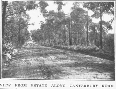 Ringwood and District Historical Society
Photograph, Coleman's Heathmont Estate Sale, 15/12/1923. Looking west along Canterbury Road Heathmont. Railway bridge is situated at foot of hill
... . Area in foreground now shopping centre both sides of road."... bridge at foot of hill 1923. Area in foreground now shopping ...Printing below photograph reads, "View from estate along Canterbury Road." Typed on backing sheet below, "Canterbury Rd. Heathmont looking towards city. Railway bridge at foot of hill 1923. Area in foreground now shopping centre both sides of road." -
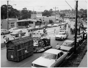 Eltham District Historical Society Inc
Photograph, Procession of Floats in Main Road Eltham, 10 Apr 1971
... The Procession of floats travelled from the Eltham Shopping... Shopping Centre to Eltham Lower Park on Saturday 10th April as part ...The Procession of floats travelled from the Eltham Shopping Centre to Eltham Lower Park on Saturday 10th April as part of the Shire of Eltham centenary celebrations program. The Infant Welfare Centre and BP service station can be seen in the background. This photo forms part of a collection of photographs gathered by the Shire of Eltham for their centenary project book," Pioneers and Painters: 100 years of the Shire of Eltham" by Alan Marshall (1971). The collection of over 500 images is held in partnership between Eltham District Historical Society and Yarra Plenty Regional Library (Eltham Library) and is now formally known as 'The Shire of Eltham Pioneers Photograph Collection.' It is significant in being the first community sourced collection representing the places and people of the Shire's first one hundred years.Digital imagesepp, shire of eltham pioneers photograph collection, shire of eltham, shire of eltham centenary, centenary celebrations, parade floats, parade, main road, eltham, infant welfare centre, bp service station -
 Hume City Civic Collection
Photograph, Late 1980's
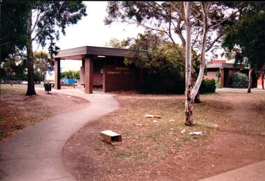
... shopping centre in Sunbury.... shopping centre in Sunbury. vandalism public toilet blocks evans ...The series of seven photographs highlight examples of vandalism within the town centre precinct. Most of the vandalism occurred on public buildings. The toilet block was demolished in the late 1990's to make way for further expansion of the retail shopping centre in Sunbury.A coloured photograph of the Sunbury Comfort Station which was erected on a section of public land in Evans Street between the post office and Sunbury Shopping Square. The brown brick building has an open porch on one side and a curved concrete path leads from the street to the building. A smaller block is in the background and a grassed ared with trees is in the foreground with rubbish thrown across the grass.vandalism, public toilet blocks, evans street, sunbury comfort station, shire of bulla, george evans collection -
 Melbourne Tram Museum
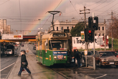
Photograph - Colour Print - Racecourse Road - Z3 203 with a rainbow
... shopping centre, stop in Racecourse Road. The tram is in The Met... Colour print of Z3 203 (Route 57) at the Newmarket Plaza shopping ...Colour print of Z3 203 (Route 57) at the Newmarket Plaza shopping centre, stop in Racecourse Road. The tram is in The Met/PTC colour scheme. In the background are the Douta Galla Hotel, the Newmarket Station railway overbridge and a rainbow. Photo c2000.Yields information about the use of the use of Z3 trams on route 57.Colour print - printed on Kodak Professional paper.trams, tramways, z3 class, tram 203, racecourse road, newmarket, route 57