Showing 10820 items
matching plans
-
 Melbourne Tram Museum
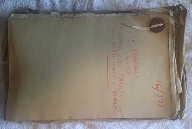
Document - Folder with papers, Public Works Department, "16/298 - Tramway Along Victoria St, Barkers Road and High Street to Burke Road", 1914 to 1916
Folder with papers or file with manila covers, secured with white cloth shoelace type retaining mechanism and red Bakelite type clips containing papers concerned with the construction of the tramway extension at Victoria Bridge (to run alongside the cable tram), the conversion of Kew Horse Tramway and construction of a new electric tramway to Burke Road - titled "16/298 - Tramway Along Victoria St, Barkers Road and High Street to Burke Road". Compiled by the Public Works Department of Victoria - generally dated 1914 to 1916 Shows the nature of the paperwork required for an Act of Parliament to authorise the work, orders in Council, drafts, actual copies of Parliamentary documents, letters to and from Councils, Members of Parliament, PMTT, plans, bridges and footpaths. Includes letters with the City of Collingwood, Kew and Richmond.trams, tramways, kew, high st, victoria st, bridges, collingwood, barkers rd, construction, cable trams, burke rd, pmtt, public works department, parliament -
 Melbourne Tram Museum
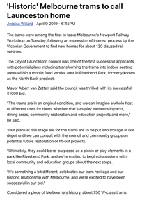
Newspaper - Digital Image, The Examiner, “'Historic' Melbourne trams to call Launceston home”, 9/4/2019
Digital image of newspaper clipping titled: “'Historic' Melbourne trams to call Launceston home”, by Jessica Willard Newspaper article with pictures of two Melbourne trams numbers 742 and 770 being loaded and transported from Newport Railway Workshop to Launceston. Initially they will be put into storage until consultation with local council and community groups. Plans include transforming the trams into indoor seating areas in Riverbend Park. The trams will travel on the Spirit of Tasmania More than 1500 applications were received through the expression of interest process, which was mostly for W-Class trams retired from Victoria's railway and tram network over the past 30 years. VicTrack is in the process of allocating all retired trams from Newport and is expected to take two years.trams, tramways, w class, w5 class, sw5 class, newport workshops, launceston, tram 742, tram 770 -
 Melbourne Tram Museum
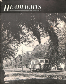
Magazine, Andrew and John Ward, "Headlights, July - August 1970", Jul. 1971
Twenty four page (24) printed black and white magazine, titled "Headlights, July - August 1970" with a photo of Melbourne 944 on the front cover. Contains an article on the Melbourne Transport Plan for 1985 and "The Tramways of Melbourne" written by John and Andrew Ward. Contains maps, photographs, tramcar roster, drawing of the Melbourne W2, details of the W7's, the St. Kilda Junction project. Also notes other Australian operations including Ballarat and Bendigo. The centre page has an additional duplicated orange page glued into the top of the sheet, from the Tramway Museum Society of Victoria, with a statement concerning the accuracy of the article. Also notes that one of the authors advised that the item had been largely re-written. Published July 1971 by the Electric Railroaders Association of New York.trams, tramways, melbourne, mmtb, planning, tmsv -
 Melbourne Tram Museum
Pamphlet, Public Transport Victoria (PTV), "Buses replace trams - Route 58 and Route 78", Jun. 2021
Pamphlet - 4 fold DL, titled ""Buses replace trams - Route 58 and Route 78", June 2021 for the installation of a level platform stop at South Yarra Station, cabling from the Daly St substation and trackwork on route 78 as well. Image i2 shows a plan of the stop - source from https://s3.ap-southeast-2.amazonaws.com/hdp.au.prod.app.vic-engage.files/3016/2201/0888/PTVH5474_South_Yarra_Tram_Design_Plan_Map_A1_v8_FA.jpg at the time. Has a map of the replacement services. Has PTV and Victorian Government logos. image i3 - downloaded from the Yarra Trams website - details of the project including upgrading the Power supply. two copies held. .1 - coffee voucher for two days (19/6 and 20/6) while tram stop works were being carried out.trams, tramways, route 58, trackwork, bus replacement, south yarra, daly st substation -
 Melbourne Tram Museum
Document - Folder with papers, Yarra Trams, "The KDR Yarra Trams Employee Roadshow Program", Oct. 2009
Folder - colour printed with various documents, part of the "The KDR Yarra Trams Employee Roadshow Program", Keolis Downer - EDI, when they took over Yarra Trams in November 2009. Has 9 separate fact A4 sheets and one folded pamphlet "Think like a passenger" Fact Sheets for: 1. Employee Roadshow program - gives dates. 2. KDR and Yarra Trams 3. Enhancing Performance 4 Delivering for Passengers 5. Customer Service 6. Find your way 7. Yarra Trams Employees 8. A new approach 9. Brand Re-fresh The "Think like a passenger" is a folded DL pamphlet, giving information about KDR and the work they planned to do the tram fleet. Has a message from Michel Masson, the CEO of Yarra Trams on the rear.trams, tramways, keolis, kdr, yarra trams -
 Bendigo Historical Society Inc.
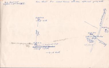
Document - MINING REPORTS - CALEB THOMAS PLANS
Copy of Caleb Thomas plans, (a) Sheet No 778, dated 24th 1884. Mines mentioned are: Catherine Reef (South) Shaft, Catherine Reef United Main Shaft, Shaft No 50B, Shaft No 51A North Shaft and the Williams Main Shaft. Mentioned are distances from each mine in yards and from the Eaglehawk to Kerang Railway in feet. Also mentioned are ounces of gold. (b) Sheet No III dated 10/10/1884. Mines mentioned are: York & Durham, Arcadia Catherine, Williams (Old) Shaft, Trio-Hauling Co, South Catherine (later Williams United Main Shaft and others by shaft numbers. Mentioned are distances in yards or feet from each mine, number of compartments and ounces of gold. Document is part of the Albert Richardson Collection.document, gold, mining reports, mining reports, caleb thomas plans, york & durham, acadia catherine, williams (old) shaft, trio-hauling co, south catherine (later williams united main shaft -
 Bendigo Historical Society Inc.
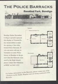
Document - THE POLICE BARRACKS ROSALIND PARK BENDIGO
Pale yellow page containing a picture and upstairs and downstairs plans of the Police Barracks, Rosalind Park, Bendigo. On the back is the history of the building and its use over the years since it was completed in 1860. On the 9 November 2002, the Bendigo Senior Secondary College presented a display of Police memorabilia to mark the opening of the refurbished Police Barracks. There were tours of the Barracks, displays and a Mounted Police display with horses. The Official Party was: Mr Graham Bastian, Principal, Bendigo Senior Secondary College, Mr Bob Cameron MP, member for Bendigo West, Ms Jacinta Allan MP, Member for Bendigo East, Ms Willi Carney, Mayor, City of Greater Bendigo, Mr Steve Gibbons MHR, Member for Bendigo and Mr Rob Blachford. There is a running sheet for the opening.buildings, government, police barracks, the police barracks rosalind park bendigo, bendigo senior secondary college, high school, bob marmion, p o flanagan, public works, alfred t snow, john robertson, bendigo goldfield, bendigo gaol, bendigo supreme court building, camp reserve, mounted constable james 'tiger' scholes 6438, education department, city of greater bendigo, graham bastian, willi carney, bob cameron mp, ms jacinta allan mp, steve gibbons mhr, bob blachford -
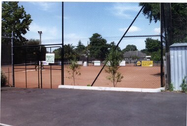
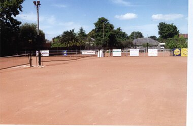
 Melbourne Tram Museum
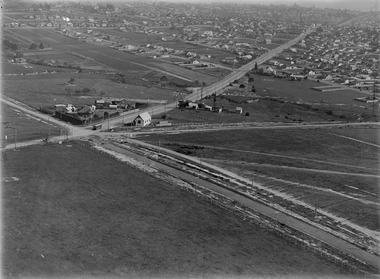
Photograph - Digital Image, Kevin O'Reilly, "Kew Burke Rd' looking at the East Kew Tram terminus, c1925
Image from CD (Compact Diskette for use in computers) - see Reg Item 135. Image titled "Kew Burke Rd' on CD, of looking at the East Kew Tram terminus with the city skyline in the background, c1925. Photo published in the Bellcord No. 16, Oct. 2012. From the article with the photograph; The terminus was located at the intersection of High St, Burke, Kilby and Doncaster Roads. We are at the outer edges of Melbourne’s suburbia at the time, unlike the current tram terminus of today. Burke Road, north of Doncaster Road is clearly under construction in preparation for the new river crossing. The vacant block of land in the foreground will remain so for another ten years or so. In 1960 the new Dickens Supermarket was built on this site and the intersection became known locally as Dickens Corner. The narrow track on the left hand side of the photo is Doncaster Road. The tram at the terminus is a straight-sill single trucker of one of the G, K, Q or R classes. It is finished in the late MMTB chocolate and cream livery. A cable grip car body has been placed as a tram shelter at the terminus. The church was subsequently relocated to Francis Street Yarraville where it still stands today as a private residence. Behind the large hedge on the south side of High Street is Smith’s Dairy. Part of this land would be sold to the MMTB for a planned new tram depot Behind the large hedge on the south side of High Street is Smith’s Dairy. Part of this land would be sold to the MMTB for a planned new tram depot but by the early 1960s it was transferred to the Education Department for construction of the Kew High School. The last portion of the dairy closed in the 1970s.trams, tramways, kew, burke rd, east kew, doncaster rd -
 Ringwood and District Historical Society
Map - Public Land Sale by Thomas Ham, 2000 Acres for Sale - Crown Sections 20, 23, 24 - Ringwood, Victoria - 1855
Two 1850s surveyor's maps on cardboard backing showing area from Melbourne extending East beyond Bulleen and Nunawading. Detailed description of lots for sale and navigational directions to the property from Richmond by Thomas Ham, Victorian public servant, map maker, publisher, lithographer and original Ringwood land owner. Inset map enlarging area between Yarra River and Dandenong Creek, with southern boundary of allotments later forming part of Oban Road, North Ringwood.TRANSCRIPT: "This really valuable Property is now offered to the public for sale, in lots to suit purchasers at the Iow rate of £1 per Acre for 80 acres and upwards, and £1.10s per Acre for any smaller portion. Terms of payment Half Cash, Balance in 6 and 12 months, bearing 8 per cent interest. The Estate is well wooded with Gum, Cherry Tree and Stringy Bark, with Wattle in the valleys of the several creeks. Every lot is Staked and Trenched at the corners marked on the Plan thus - The Surveyor has carefully sub-divided the Property, in order to give every Farm a Creek for Water, Valley for Cultivation, and Hills for House and Grass Paddock. The ROADS have been very carefully laid out so as to give a firm, well drained, and nearly level road to each Homestead. Intending purchasers can readily find the property by the following directions, viz: Start from Richmond Bridge, at Hawthorne, then take the left-hand road to KEW. When at the "Woodman Inn", take the Cotham Road to the right, bearing due east, keep this Road, passing Trainor's "White Horse" Inn, and before you leave the fences, you will see calico bills (see margin) nailed to the Trees on the bush track leading to the Upper Yarra country, follow the Bills till you come to the SOUTH boundary line of the Property, which bears East and West (see Plan) where you will see Bills nailed up "THIS PROPERTY FOR SALE, etc." The Bills from Town lead direct to where Mr. Jull is erecting his Store, and arrangements have been made with him to show the lots to intending purchasers free of charge. At the respective corners of the lots the Bills are nailed up double, with numbers to denote the lot, and that the corner stake is adjacent. Any parties wishing to proceed to the property by way of BULLEEN will find Bills nailed on the Trees, commencing at the NEW INN, at "Wilson's Slip Rail." Keep this Track till you come to the Log Bridge, over the Deep Creek at Bloxhome's Paddock; go through the land now being cleared; keep the track over the hill till you come to an Iron House, you will then be on the property, which Iies to the North and East as per Plan. Follow the Bills till you come to Mr. Jull's Store, etc. etc. Further particulars can be had from the Agent for the Property. THOMAS HAM. " -
 Warrnambool and District Historical Society Inc.
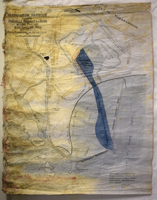
Map - Map of Proposed Alterations to Warrnambool Harbour 1925, Warrnambool Harbour Committee, Warrnambool Harbour Proposed Wharves and Basin in Lake Pertobe with Eastern Wall, 1925
This map was printed in 1925 and contains the Warrnambool Harbour alterations proposed by the Warrnambool Harbour Committee incorporating the original designs of Captain Menzies, the Warrnambool Harbour Master and the City Engineer, Mr A. Lavercombe. The main features of the proposal were the extension of the Eastern Wall to almost enclose the harbour and a basin in Lake Pertobe. The design was to be placed before the Victorian Royal Commission on the Outer Ports which was established partly to examine the allegations of unsatisfactory work carried out in Warrnambool when the Breakwater was extended 300 feet in 1914 and also to make recommendations regarding all regional ports. The Warrnambool Breakwater was completed in 1890 but failed to provide the shipping conditions needed to continue Warrnambool as a viable port. Many plans and proposals for port improvement such as this one were produced in the late 19th century and the first half of the 20th century with the port officially closed in the 1940s. Still today the Breakwater and Warrnambool Harbour conditions remain a source of contention.This map is significant as it shows a 1925 design for Warrnambool Harbour hitherto little-known. It also has markings showing land sites of the time (BayView Hotel, Woollen Mill etc.)This is a map made of thick yellow paper pasted onto a cloth backing. It has two cloth tags at the top for tying up the map when folded. It appears to be a hand-drawn map copied with printed material added. The map is shaded green and red in some areas. Attached by nails to the map are wooden frames, rounded at the bottom and partly curved at the top. The map is torn and partly detached at the top. The top frame has a cord attached for hanging the map.warrnambool harbour, captain menzies, a.lavercombe city engineer, warrnambool breakwater, royal commission on outer ports -
 Eltham District Historical Society Inc
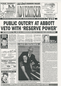
Document - News Clipping, Advertiser, Public Outcry at Abbott Veto with 'Reserve Power; 200 residents yell abuse as commissioners give ok to Eltham service station; Advertiser, Tuesday, October 15, p1, 1996
Nillumbik Commissioners used 'reserve power's to permit a controversial Shell service station and Hungry Jackls restaurant development at the former Eltham Shire Office site at 895 Main Road. More than 200 people attended the Council meeting in the public gallery and protested at the decision. 32 personal submissions were made to Council's Planning Special Committee meeting whose members vioted 3-2 against the development. The Committee consisted of the three Nillumbik Commissioners and three community members (Jim Connor, Bronwyn South and Janet Mattiske). Chief Commissioner Don Cordell, a former Shell employee excused himself from voting and the three communbity memebrs voted against the submission. The other two commissioners, Vin Heffernan and Kevin Abbott voted against it. They then immediately closed the meeting and opened a Council meeting lasting just seconds to use special reserve powers to overturn the decision. The demolition of the former Shire of Eltham offices and proposed sale and development driven by the Commissioners for Nillumbik Shire Council brought the community together in substantial protest at the infrigement of ratepayers democratic say in local government and ciommunity assets combined with protests about inappropraite development of Eltham's Gateway. This issue led to the formation of the Eltham Community Action Group which still operates strongly today (2023) on behalf of the community to ensure appropriate development within the community.895 main road, commissioners, dallas price homes, development application, eltham hub, hungry jacks, nillumbik shire council, re-zoning, shell service station, town planning, eltham gateway, eltham gateway action group, eltham shire offices, shillinglaw farm, shillinglaw trees, jim connor collection, dallas howgate, frank burgoyne, robert marshall, nillumbik planning special committee, jim connor, bronwyn south, janet mattiske, don cordell, vin heffernan, kevin abbott -
 Eltham District Historical Society Inc
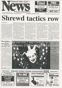
Document - News Clipping, Jodie Guest, Shrewd tactics row, Diamond Valley News, October 15, p1, 1996
Nillumbik Commissioners used 'reserve power's to permit a controversial Shell service station and Hungry Jackls restaurant development at the former Eltham Shire Office site at 895 Main Road. More than 200 people attended the Council meeting in the public gallery and protested at the decision. 32 personal submissions were made to Council's Planning Special Committee meeting whose members vioted 3-2 against the development. The Committee consisted of the three Nillumbik Commissioners and three community members (Jim Connor, Bronwyn South and Janet Mattiske). Chief Commissioner Don Cordell, a former Shell employee excused himself from voting and the three communbity memebrs voted against the submission. The other two commissioners, Vin Heffernan and Kevin Abbott voted against it. They then immediately closed the meeting and opened a Council meeting lasting just seconds to use special reserve powers to overturn the decision. The demolition of the former Shire of Eltham offices and proposed sale and development driven by the Commissioners for Nillumbik Shire Council brought the community together in substantial protest at the infrigement of ratepayers democratic say in local government and ciommunity assets combined with protests about inappropraite development of Eltham's Gateway. This issue led to the formation of the Eltham Community Action Group which still operates strongly today (2023) on behalf of the community to ensure appropriate development within the community.895 main road, commissioners, dallas price homes, development application, eltham hub, hungry jacks, nillumbik shire council, re-zoning, shell service station, town planning, eltham gateway, eltham gateway action group, eltham shire offices, shillinglaw farm, shillinglaw trees, jim connor collection, dallas howgate, nillumbik planning special committee, jim connor, bronwyn south, janet mattiske, don cordell, vin heffernan, kevin abbott -
 Glen Eira Historical Society
Plan - Craigellachie
A four page auction advertisement from Gary Peer Real Estate for the forthcoming auction of Craigellachie to be held 29/05/2011. The advertisement includes one coloured photograph of the exterior of the house (170mm x 200mm) and three coloured photographs (140mm x 200mm; 80mm x 100mm; 80mm x 100mm) of the interior of the house showing period features. It also includes a detailed plan (200mm x 150mm) of the house layout and garden. The file also includes a one page black and white photocopy of an auction advertisement for Craigellachie which provides a brief overview of the renovations on Craigellachie conducted by the current owners, outlines architectural features of the house, and gives a brief history of Craigellachie. This is written by Maria Harris. The advertisement includes two photographs (63mm x 58mm; 131mm x 142mm) of the interior of Craigellachie and two photographs (62mm x 83mm; 62mm x 57mm) of the interior of Craigellachie.craigellachie, lynedoch avenue, gary peer real estate, harris maria, st kilda east, estate agents, pearson william, orrong road, caulfield north, architectural styles, architectural features -
Glen Eira Historical Society
Article - Fairfield Hall, North Road, 225, Caulfield South
A Melbourne Weekly newspaper cutting by Kathryn Kernohan, advertising the forthcoming auction of Fairfield Hall at 225 North Road, Caulfield South, to be held 09/10 circa 2007. The article provides a description of the house’s architectural features and includes two colour photographs (83mm x 155mm; 69mm x 102mm) of the exterior of the house and one colour photograph (67mm x 102mm) of the house interior. The file also includes a four page pamphlet of Real Estate agents J P Dixon, advertising the auction of Fairfield Hall. The pamphlet provides a description of the house’s architectural features and includes four colour photographs (296mm x 210mm; 78mm x 103mm; 134mm x 200mm; 84mm x 55mm) of the house exterior, four colour photographs (49mm x 72mm; 49mm x 72mm; 66mm x 44mm; 84mm x 126mm) of the house interior, and a plan (225mm x 140mm) of the house and gardens.north road, kernohan kathryn, caulfield south, architectural features, jp dixon real estate, fairfield hall, mansions, victorian style, caulfield, younger avenue -
 Flagstaff Hill Maritime Museum and Village
Container - Tin, c. 1930-1955s
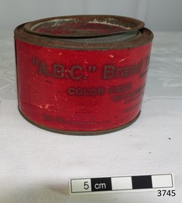
This metal tin once contained sewing silk thread used in the making of the ship model, Sovereign of the Seas. Natural silk thread has elasticity and can also be teased out for making fine line for rigging on ship models. ”. It is part of a collection of objects used by Jim Williams, maker of fine ship models from about 1930-1955. Most of the components for the models, as well as many of the tools, were handmade by Jim Williams. Ship model of HMS Sovereign of the Seas, scale model of 17th Century English war ship, was handmade and carved from plans, enclosed in airtight glass case. All components of that model, including even the smallest pulleys, were hand crafted using tools designed and made by Jim. Outstanding details include functional rigging and moving cannons. Please see our record 3732 of the mode Sovereign of the Seas for further details of the ship and the maker. This tin of tailor's silk is connected with the hobby and skill of ship model making that has been crafted as a leisure activity for many generations. The hobby is often chosen by serving and retired mariners who appreciate the connection with maritime history. This tailor's silk was used by local Warrnambool man, Jim Williams, who was employed at Cramond and Dickson clothing store, and then at Fletcher Jones menswear for 27 years. It was used in making components for the model of the historic ship, the Sovereign of the Seas. The Sovereign of the Seas was a historic 17th century English war ship with important maritime heritage.Tin, round, with lid. Red label reads “The "A.B.C" Brand Tailors Sewing Silk (Raven) Color Fast. Dyed by a new process. Manufactured from the best raw silks procurable. Warranted. Made in England. Size No. 1/4 LB” .The container has no contents. This tin is part of a collection of tools and accessories once used by Jim Williams, maker of a series of ship models 1930-1955 including “HMS Sovereign of the Seas”. “The "A.B.C" Brand Tailors Sewing Silk (Raven) Color Fast. Dyed by a new process. Manufactured from the best raw silks procurable. Warranted. Made in England. Size No. 1/4 LB”, Logo on lid is the intertwined letters of “A.B.C.” flagstaff hill, warrnambool, shipwrecked coast, flagstaff hill maritime museum, maritime museum, shipwreck coast, flagstaff hill maritime village, great ocean road, ship model sovereign of the seas, jim williams, james bernard williams, ship model tools, ship model making, ship model making accessories, "a.b.c" brand tailors sewing silk, silk sewing thread, textile, tin container for silk thread, ship model, hobby, ship model tool, english war ship -
 Flagstaff Hill Maritime Museum and Village
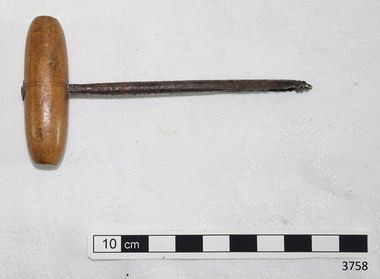
Tool - Auger, 1930-1955's
This auger was used in the making of components for the ship model Sovereign of the Seas. It is part of a collection of objects used by Jim Williams, maker of fine ship models from about 1930-1955. Most of the components for the models, as well as many of the tools, were handmade by Jim Williams. Jim’s family has donated the ship model “Sovereign of the Seas” and many tools, accessories and documents used in the making of this and other ship models have been donated to Flagstaff Hill Maritime Village. Ship model of HMS Sovereign of the Seas, scale model of 17th Century English war ship, was handmade and carved from plans, enclosed in airtight glass case. All components of that model, including even the smallest pulleys, were hand crafted using tools designed and made by Jim. Outstanding details include functional rigging and moving cannons. Please see our record 3732 of the mode Sovereign of the Seas for further details of the ship and the maker. This auger is connected with the hobby and skill of ship model making that has been crafted as a leisure activity for many generations. The hobby is often chosen by serving and retired mariners who appreciate the connection with maritime history. This auger was used by local Warrnambool man, Jim Williams, who was employed at Cramond and Dickson clothing store, and then at Fletcher Jones menswear for 27 years. It was used in making components for the model of the historic ship, the Sovereign of the Seas. The Sovereign of the Seas was a historic 17th century English war ship with important maritime heritage. Small auger, metal shank with threaded tip, and light coloured, oval shaped wooden handle. This auger is part of a collection of tools and accessories once used by Jim Williams, maker of a series of ship models 1930-1955 including “HMS Sovereign of the Seas”. flagstaff hill, warrnambool, flagstaff hill maritime museum, maritime museum, shipwreck coast, flagstaff hill maritime village, great ocean road, jim williams, james bernard williams, ship model hobby, ship model tools, ship model making equipment, ship model making accessories, auger, hand tool, sovereign of the sea, ship model, hobby, ship model tool, tool -
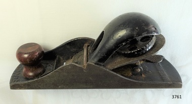 Flagstaff Hill Maritime Museum and Village
Tool - Plane, 1930-1955's
This Stanley plane was used in the making of components for the ship model Sovereign of the Seas. It is part of a collection of objects used by Jim Williams, maker of fine ship models from about 1930-1955. Most of the components for the models, as well as many of the tools, were handmade by Jim Williams. Jim’s family has donated the ship model “Sovereign of the Seas” and many tools, accessories and documents used in the making of this and other ship models have been donated to Flagstaff Hill Maritime Village. Ship model of HMS Sovereign of the Seas, scale model of 17th Century English war ship, was handmade and carved from plans, enclosed in airtight glass case. All components of that model, including even the smallest pulleys, were hand crafted using tools designed and made by Jim. Outstanding details include functional rigging and moving cannons. Please see our record 3732 of the mode Sovereign of the Seas for further details of the ship and the maker. This plane is connected with the hobby and skill of ship model making that has been crafted as a leisure activity for many generations. The hobby is often chosen by serving and retired mariners who appreciate the connection with maritime history. This plane was used by local Warrnambool man, Jim Williams, who was employed at Cramond and Dickson clothing store, and then at Fletcher Jones menswear for 27 years. It was used in making components for the model of the historic ship, the Sovereign of the Seas. The Sovereign of the Seas was a historic 17th century English war ship with important maritime heritage. Plane, No 120, made in USA by Stanley. This small plane is part of a collection of tools and accessories once used by Jim Williams, maker of a series of ship models 1930-1955 including “HMS Sovereign of the Seas”."Stanley", "USA", "No. 120"flagstaff hill, warrnambool, flagstaff hill maritime museum, maritime museum, shipwreck coast, flagstaff hill maritime village, great ocean road, jim williams, james bernard williams, ship model hobby, ship model tools, ship model making equipment, ship model making accessories, wood working tool, plane, stanley of usa, sovereign of the sea, ship model, hobby, ship model tool -
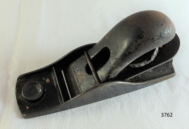 Flagstaff Hill Maritime Museum and Village
Tool - Plane, 1930-1955's
This small plane was used in the making of components for the ship model Sovereign of the Seas. It is part of a collection of objects used by Jim Williams, maker of fine ship models from about 1930-1955. Most of the components for the models, as well as many of the tools, were handmade by Jim Williams. Jim’s family has donated the ship model “Sovereign of the Seas” and many tools, accessories and documents used in the making of this and other ship models have been donated to Flagstaff Hill Maritime Village. Ship model of HMS Sovereign of the Seas, scale model of 17th Century English war ship, was handmade and carved from plans, enclosed in airtight glass case. All components of that model, including even the smallest pulleys, were hand crafted using tools designed and made by Jim. Outstanding details include functional rigging and moving cannons. Please see our record 3732 of the mode Sovereign of the Seas for further details of the ship and the maker. This plane is connected with the hobby and skill of ship model making that has been crafted as a leisure activity for many generations. The hobby is often chosen by serving and retired mariners who appreciate the connection with maritime history. This plane was used by local Warrnambool man, Jim Williams, who was employed at Cramond and Dickson clothing store, and then at Fletcher Jones menswear for 27 years. It was used in making components for the model of the historic ship, the Sovereign of the Seas. The Sovereign of the Seas was a historic 17th century English war ship with important maritime heritage. Small metal plane with the number impressed in the heel “102”. This small plane is part of a collection of tools and accessories once used by Jim Williams, maker of a series of ship models 1930-1955 including “HMS Sovereign of the Seas”."102"flagstaff hill, warrnambool, flagstaff hill maritime museum, maritime museum, shipwreck coast, flagstaff hill maritime village, great ocean road, jim williams, james bernard williams, ship model hobby, ship model tools, ship model making equipment, ship model making accessories, wood working tool, wood working plane, carpentry plane, sovereign of the sea, ship model, hobby, ship model tool, tool -
 Flagstaff Hill Maritime Museum and Village
Tool - Gauge, 1930-1955's
This gauge was used in the making of components for the ship model Sovereign of the Seas. It is part of a collection of objects used by Jim Williams, maker of fine ship models from about 1930-1955. Most of the components for the models, as well as many of the tools, were handmade by Jim Williams. Jim’s family has donated the ship model “Sovereign of the Seas” and many tools, accessories and documents used in the making of this and other ship models have been donated to Flagstaff Hill Maritime Village. Ship model of HMS Sovereign of the Seas, scale model of 17th Century English war ship, was handmade and carved from plans, enclosed in airtight glass case. All components of that model, including even the smallest pulleys, were hand crafted using tools designed and made by Jim. Outstanding details include functional rigging and moving cannons. Please see our record 3732 of the mode Sovereign of the Seas for further details of the ship and the maker. This gauge is connected with the hobby and skill of ship model making that has been crafted as a leisure activity for many generations. The hobby is often chosen by serving and retired mariners who appreciate the connection with maritime history. This gauge was used by local Warrnambool man, Jim Williams, who was employed at Cramond and Dickson clothing store, and then at Fletcher Jones menswear for 27 years. It was used in making components for the model of the historic ship, the Sovereign of the Seas. The Sovereign of the Seas was a historic 17th century English war ship with important maritime heritage. Gauge; marking gauge, wooden. Wooden handle threaded through hole in wooden block, adjusted along the handle by tightening a wing-nut screw. The end of the handle has a pointed pin fitted for scoring a mark on the work surface to mark timber before cutting. This gauge is part of a collection of tools and accessories once used by Jim Williams, maker of a series of ship models 1930-1955 including “HMS Sovereign of the Seas”.flagstaff hill, warrnambool, flagstaff hill maritime museum, maritime museum, shipwreck coast, flagstaff hill maritime village, great ocean road, jim williams, james bernard williams, ship model hobby, ship model tools, ship model making equipment, ship model making accessories, wood working tool, model making tool, drawing instrument, gauge, tool, sovereign of the sea, ship model, hobby, ship model tool -
 Mortlake and District Historical Society
Photograph - Montgomery Pavillion, Montgomery Pagoda or Pavillion, 1924
In July 1922 Rev. W. McBride of the St Andrews Presbyterian Church, Mortlake had a meeting with the Garden sub-committee to discuss how the 500 pounds sterling bequest from the Late Thomas Montgomery could best be spent. His suggestion was that the money should be spent on either a kiosk, pavillion or recreation hall and pavillion combines with kitchen and fireplace was agreed to with exact site to decided at a public meeting. Cr Montgomery, a local businessman and a councillor, had loved the gardens and had assisted to transform the area from a swamp into a thing of beauty. The design was chosed by his widow who had seen a smilar design in King's Park whilst in Perth so the plans were obtained from that City. The work was carried out by Archibald Cluny McDonald and completed in September 1924. In December 1924 the Montgomery Pagado was unveiled to the public by Cr Wells Brumley after which the Red Cross ladies served tea.THIS TABLET IS DESIGNED TO COMMEMORATE THE GENEROSITY OF THE LATE COUNCILLOR THOMAS MONTGOMERY BY WHOM THIS PAVILLION WAS GRACIOUSLY BEQUEATHED TO THE TOWN OF MORTLAKE AND TO PERPETUATE THE MEMORY OF HIS NOBILITY OF CHARACTER AND EXTREME WORTH AS A CITIZENpagoda -
 Greensborough Historical Society
Photograph - Digital Image, Art at WaterMarc, July 2017, 22/07/2017
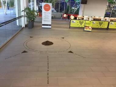
Photographs of an art installation by Jessie Stanley at WaterMarc Greensborough on 22/07/2017. From Jessie Stanley's FaceBook page :Dust to Dust is complete... It's an ephemeral site-specific work about how the Melbourne suburb of Greensborough has transformed over time. This area's exceptionally fertile soil [used by] by white settlers for farms, market gardens and orchards reshaped the Wurundjeri's traditional lands - and today the private sale and division of these farms informs the streetscape and town plan. With soil sourced locally this work reveals some of the area’s history - the text running around the perimeter was written by former resident Val Wilson, a snippet of her recollections of growing up in the area in the 1950s. The arrows and text act like a compass to orientate this site with greater Melbourne. On display in the lobby of Banyule Council until chance, time (or a broom) sweeps it away, Many thanks to Banyule City Council, Greensborough Historical Society and Valerie Wilson. "An artistic representation of Greensborough's history.Digital photographs of art installation.jessie stanley, watermarc, greensborough historical society, banyule council -
 Eltham District Historical Society Inc
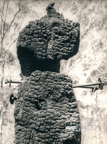
Photograph, George W. Bell, Diamond Creek, 1969, 1969
Canberra Times (ACT : 1926 - 1995), Thursday 9 January 1969, page 1 A day of century heat, 13 KILLED IN VICTORIAN FIRES ...About thirty houses and a public hall were destroyed by fire in the township of Diamond Creek. The group officer of the Diamond Creek Fire Brigade, Mr Tom Harrington, said tonight that he thought it was a "miracle" that no-one lost their lives in the fires. A relief centre for the homeless was set up by the Diamond Valley Shire Council. Mr Harrington said that the first fire call in the town was received at 10.45 am. "Within 20 minutes there were five more fires and it seemed like the whole town was alight", he said. "It was a chaotic day. All our best plans for fighting the fires became disorganised. "As 60-mile-an-hour winds swept fires through different parts of the town many fire fighters were unable to get from one fire to another. ," Black and white photograph of charred fire remnant Diamond Creek 1969diamond creek, fire, george w bell collection, bushfire, charred, burnt timber -
 Australian Commando Association - Victoria
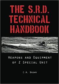
The Official History of Special Operations Australia SRD Technical Handbook
This book reproduces the SRD Technical Handbook, which was a top secret equipment supply catalogue published for internal use within SRD in February, 1945. While many of the items in the handbook are British SOE “special stores” shipped over from London, a great deal of developmental and experimental work was done by SRD’s Technical Directorate at its technical research station at Mount Martha on Victoria’s Mornington Peninsula. A flick through these pages will show unusual items such as folding midget motorbikes, silenced pistols and machine guns, knuckle-knives, mini-submarines, booby trap devices and more. In fact, it contains just about everything a WWII-era commando or a spy required to successfully complete a secret mission. Lavishly illustrated with original wartime photographs, plans and diagrams, many never before seen publicly, the S.R.D. Technical Handbook is timely evidence that mankind is never as ingenious as he is during time of war.australian special operations, special forces, commandos, world war ii -
 Flagstaff Hill Maritime Museum and Village
Artwork, other - A religious print and almanac, Australasian Church of Christ, 1892
This religious almanac with biblical imagery listed the Churches of Christ in Australasia and scripture readings for a calendar year of 1892. The almanac was produced and updated annually to reflect current information. The Churches of Christ in Australia is a Reformed Restorationist denomination. Congregations in South Australia, Victoria and New South Wales were established by individuals who travelled to these colonies to pursue employment opportunities, elsewhere in Australia Churches of Christ congregations were established as missionary initiatives. Churches of Christ in Victoria began with the arrival of the Ingram and Picton families from England who established regular meetings in Prahran and officially constituted a congregation in 1855. In Warrnambool plans were drawn up in 1883 for the erection of a Church of Christ at 12 Spence Street. The church was opened in 1885 with visiting pastors until a resident minister, A. J. Fisher, was appointed in 1915. This church was closed early in the 21st century when a new church, Gateway Church of Christ, was opened in Ragland Parade in Warrnambool. A rare survival of social and spiritual ephemera related to the Christian worship throughout Australia during the late nineteenth century. Portrait of a religious female figure wearing a simple dress with a crucifix around her neck. On the rear of the frame is an 1892 Australasian Church of Christ Almanac for suggested scripture readings. One of a pair.flagstaff hill, warrnambool, maritime museum, 1892, almanac, scripture readings, australiasian church of christ, church, religion, christianity -
 Glen Eira Historical Society
Photograph, Dalny Road, 5-17 Rear, Murrumbeena, 2001
Originally labelled "Beauville Estate, Established 1936, Still Thriving 65 years on, 10th March 2001", the Beauville Estate Album contains colour photographs of houses in the Estate. They were taken around the time of the Beauville Estate’s 65th Heritage Celebration held on 10/03/2001 and donated to the Caulfield Historical Society shortly afterwards. Photographer unknown. From Glen Eira’s Heritage Management Plan by Andrew Ward (1996) Vol 2 p78: "Beauville Avenue is unusual in that it is terminated in a cul-de-sac (see Section 3.9.2) whilst the design of the estate may well be unique for its time in that the houses back onto 6 tennis courts for public use. St. Patrick's Church, which adjoins the estate is a comparatively recent structure whilst the school has one building erected in 1930 and prior to the release of the Beauville lots." It also notes that St.Patrick's Church and School now run the tennis courts. The Beauville Historic Area is important at the State level as the first large housing estate undertaken by the AV Jennings Construction Co, later Jennings Group Limited, Victoria’s largest home builder. It is important also as a very early estate development incorporating a range of features other than houses and including made roads, shops and recreation facilities. In this respect it was the forerunner of the comprehensively planned housing estate of the post war era. The estate is distinguished by its aesthetic values, as is the earlier and comparable Hillcrest Estate, which are formed by a combination of restrained diversity in house styles, with the exception of no. 30 in the emerging International style, and by a landscaped garden environment. See Significance Statement in Glen Eira’s Heritage Management Plan by Andrew Ward (1996) Vol 2 p.79. Available from https://www.gleneira.vic.gov.au/media/4779/heritage_management_plan_volume_2.pdf (Note see p.84 of pdf)Colour photograph of a playground on the Beauville Estate. murrumbeena, houses, 1930's, a.v. jennings, av jennings, jennings, beauville estate, playgrounds, parks and reserves, sir albert victor jennings, a v jennings construction co, beauville estate heritage area, glen eira city council, jennings group limited, land subdivision, gardens, beauville historic area, st patrick's church, st patrick's school, dalny road -
 Glen Eira Historical Society
Photograph, Dalny Road, 5-17 Rear, Murrumbeena, 2001
Originally labelled "Beauville Estate, Established 1936, Still Thriving 65 years on, 10th March 2001", the Beauville Estate Album contains colour photographs of houses in the Estate. They were taken around the time of the Beauville Estate’s 65th Heritage Celebration held on 10/03/2001 and donated to the Caulfield Historical Society shortly afterwards. Photographer unknown. From Glen Eira’s Heritage Management Plan by Andrew Ward (1996) Vol 2 p78: "Beauville Avenue is unusual in that it is terminated in a cul-de-sac (see Section 3.9.2) whilst the design of the estate may well be unique for its time in that the houses back onto 6 tennis courts for public use. St. Patrick's Church, which adjoins the estate is a comparatively recent structure whilst the school has one building erected in 1930 and prior to the release of the Beauville lots." It also notes that St.Patrick's Church and School now run the tennis courts.City of Glen Eira’s Heritage Management Plan Vol 2 p79 (this is p84 of the pdf version) – HO12 Beauville Estate and environs, Murrumbeena: The Beauville Historic Area is important at the State level as the first large housing estate undertaken by the AV Jennings Construction Co, later Jennings Group Limited, Victoria’s largest home builder. It is important also as a very early estate development incorporating a range of features other than houses and including made roads, shops and recreation facilities. In this respect it was the forerunner of the comprehensively planned housing estate of the post war era. The estate is distinguished by its aesthetic values, as is the earlier and comparable Hillcrest Estate, which are formed by a combination of restrained diversity in house styles, with the exception of no. 30 in the emerging International style, and by a landscaped garden environment. Colour photograph of a tennis club house and a park on the Beauville Estate. murrumbeena, houses, 1930's, a.v. jennings, av jennings, jennings, beauville estate, jennings albert victor, parks and reserves, sports and recreations establishments, clubhouses, tennis clubs, beauville tennis courts, st patrick's tennis club, sir albert victor jennings, a v jennings construction co, beauville estate heritage area, glen eira city council, architectural features, jennings group limited, land subdivision, gardens, beauville historic area, dalny road -
 Glen Eira Historical Society
Photograph, Dalny Road, 5-17 Rear, Murrumbeena, 2001
Originally labelled "Beauville Estate, Established 1936, Still Thriving 65 years on, 10th March 2001", the Beauville Estate Album contains colour photographs of houses in the Estate. They were taken around the time of the Beauville Estate’s 65th Heritage Celebration held on 10/03/2001 and donated to the Caulfield Historical Society shortly afterwards. Photographer unknown. From Glen Eira’s Heritage Management Plan by Andrew Ward (1996) Vol 2 p78: "Beauville Avenue is unusual in that it is terminated in a cul-de-sac (see Section 3.9.2) whilst the design of the estate may well be unique for its time in that the houses back onto 6 tennis courts for public use. St. Patrick's Church, which adjoins the estate is a comparatively recent structure whilst the school has one building erected in 1930 and prior to the release of the Beauville lots." It also notes that St.Patrick's Church and School now run the tennis courts.City of Glen Eira’s Heritage Management Plan Vol 2 p79 (this is p84 of the pdf version) – HO12 Beauville Estate and environs, Murrumbeena: The Beauville Historic Area is important at the State level as the first large housing estate undertaken by the AV Jennings Construction Co, later Jennings Group Limited, Victoria’s largest home builder. It is important also as a very early estate development incorporating a range of features other than houses and including made roads, shops and recreation facilities. In this respect it was the forerunner of the comprehensively planned housing estate of the post war era. The estate is distinguished by its aesthetic values, as is the earlier and comparable Hillcrest Estate, which are formed by a combination of restrained diversity in house styles, with the exception of no. 30 in the emerging International style, and by a landscaped garden environment. Colour photograph of tennis courts and surrounding mesh fencing on the Beauville Estate. murrumbeena, houses, 1930's, a.v. jennings, av jennings, jennings, beauville estate, parks and reserves, sports and recreations establishments, tennis courts, sportsgrounds, sir albert victor jennings, a v jennings construction co, beauville estate heritage area, glen eira city council, architectural features, jennings group limited, land subdivision, gardens, beauville historic area, tennis clubs, beauville tennis courts, st patrick's tennis club, dalny road -
 Glen Eira Historical Society
Photograph, Dalny Road, 5-17 Rear, Murrumbeena, 2001
Originally labelled "Beauville Estate, Established 1936, Still Thriving 65 years on, 10th March 2001", the Beauville Estate Album contains colour photographs of houses in the Estate. They were taken around the time of the Beauville Estate’s 65th Heritage Celebration held on 10/03/2001 and donated to the Caulfield Historical Society shortly afterwards. Photographer unknown. From Glen Eira’s Heritage Management Plan by Andrew Ward (1996) Vol 2 p78: "Beauville Avenue is unusual in that it is terminated in a cul-de-sac (see Section 3.9.2) whilst the design of the estate may well be unique for its time in that the houses back onto 6 tennis courts for public use. St. Patrick's Church, which adjoins the estate is a comparatively recent structure whilst the school has one building erected in 1930 and prior to the release of the Beauville lots." It also notes that St.Patrick's Church and School now run the tennis courts. City of Glen Eira’s Heritage Management Plan Vol 2 p79 (this is p84 of the pdf version) – HO12 Beauville Estate and environs, Murrumbeena: The Beauville Historic Area is important at the State level as the first large housing estate undertaken by the AV Jennings Construction Co, later Jennings Group Limited, Victoria’s largest home builder. It is important also as a very early estate development incorporating a range of features other than houses and including made roads, shops and recreation facilities. In this respect it was the forerunner of the comprehensively planned housing estate of the post war era. The estate is distinguished by its aesthetic values, as is the earlier and comparable Hillcrest Estate, which are formed by a combination of restrained diversity in house styles, with the exception of no. 30 in the emerging International style, and by a landscaped garden environment. Colour photograph of tennis courts with lights on the Beauville Estate. murrumbeena, houses, 1930's, a.v. jennings, av jennings, jennings, beauville estate, parks and reserves, sports and recreations establishments, tennis courts, sportsgrounds, sir albert victor jennings, a v jennings construction co, beauville estate heritage area, glen eira city council, architectural features, jennings group limited, land subdivision, gardens, beauville historic area, tennis clubs, beauville tennis courts, st patrick's tennis club, dalny road -
Glen Eira Historical Society
Article - ELSTER AVENUE, 18, ELSTERNWICK
This file contains 5 items about this property: 1/Handwritten notes from titles searches of 18 Elster Avenue complied by Peta Darke dated 29/07/2014 – photocopy 7 pages. 2/Handwritten list of Sands & McDougall entries for 1915 to 1970, and notes to present, compiled by Peta Darke dated 29/07/2014. 3/Photocopy of two pages of the title to the property dated 22/10/1909. Includes plan of subdivision of the area. 4/Photocopies of five advertisements from The Argus relating to the property: 28/08/1918 Land Wanted 12/07/1921 Lost Heifer 26/04/1919 Owner has House For Sale (20 Elster Avenue) 10/05/1919 same – No. 20 For Sale 29/11/1927 M. M. Taylor has Oats and Barley For Sale. 5/Photocopy of photograph of exterior taken by R. Darke circa 1998.elsternwick, gardenvale, elster avenue, robinson charles, caulfield, robinson william henry, robinson george augustus, inglis robert, davies matthew henry, ross william murray, colonial investment and agency company, victorian permanent property investment and building society, calder william anderson, watson john, rosstown junction railway and property company, kooyong road, college street, parnell (muntz) street, lempriere john thomson, thomson william hamilton, collinson william morris, elizabeth street, cumming euphemia, taylor thomas, hill caroline, evans alexander cameron, evans horace, evans gordon lemaitre, roach joyce rubena, evans mary arthur, nallo luigi, nallo joyce, north road, darke richard alexander, darke peta, peile edgar stoddart, corio, darke caroline elizabeth, darke cameron andrew, oswald street, bertram street, taylor m. m., land subdivision, architectural styles, edwardian style, brick houses, teak street, caulfield south -
Glen Eira Historical Society
Letter - Organs
This file contains three items relating to: 1/A photocopy of a letter to the Manager Strategic Planning and Sustainability on the Glen Eira City Council from Paul Roser from the National Trust, 21/07/2011, advising that the J. W. Wolff Pipe Organ in St. Aloysius Catholic Church, Balaclava Road, Caulfield has been included in the National Trust Register. 2/A photocopy of a letter to Vicar B. Green of St. Mary’s Anglican Church, Caulfield, from Ian Wight from the National Trust, 21/05/1996, advising that the pipe organ in St. Mary’s Anglican Church has been included in the National Trust Register. 3/A photocopy of a letter to the Chief Executive Officer of the City of Caulfield from Douglas Hill of the National Trust, 11/10/1990, advising that the Merklin-Schutze Organ located in the Uniting Church, 66 Orrong Road, Elsternwick has been included in the National Trust Register.national trust, glen eira city council, caulfield south, st. aloysius catholic church caulfield, balaclava road, roser paul, green b. vicar, st. mary’s anglican church caulfield, caulfield, glen eira road, hood street, wight ian, orrong road, elsternwick, uniting church elsternwick, hill douglas, organs, musical instruments, churches