Showing 9904 items
matching head
-
 Kiewa Valley Historical Society
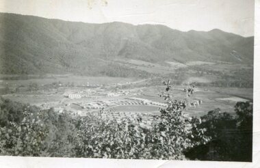
Photo - Bogong Township, March 1944
In 1940 Field Headquarters for the Kiewa Scheme were established at Bogong with office, workshop facilities and accommodation for workmen, staff and some families constructed. (There had been a 'tent camp' on this site in 1939 but was destroyed by bushfires) Construction of accommodation continued until 1947. A total of 40 houses plus a hostel for single staff, post office, police station, medical centre and primary school all with water and sewerage and electricity supply. The staff hostel was known as Kiewa House and is now occupied by the Education Department. Lake Guy was named after Mr. L.T. Guy who was the Resident Engineer in charge of construction work and associated activities on the Kiewa area. He held this position from 1939 to November 1946 when he was transferred to Head Office. The Bogong Township was developed firstly as an accommodation centre (base camp) for construction workers employed under the Kiewa Hydroelectric Scheme. Due to the influx of European workers into the Township the beautification of the immediate surrounds (gardens etc.) had a distinct European flavour. This environment has been very beneficial for tourism in later years. At the completion of the scheme, in the 1960's, the village was opened to public/tourism use. Strict environmental control has not allowed for any extensive redevelopment in tourist accommodation and basically restricted it to the accommodation initially built for the construction workers. Activities such a bike riding, snow skiing, restricted horse riding and bush walking on the Alpine plains and mountains are now a viable part of the Kiewa Valley Tourist Industry. The lake is one of the many water storage reservoirs used to supply the power stations their main power to run the huge turbines generating the final product, electricityBlack and white photograph of Bogong Township taken March 1944Handwritten on the back of photo - Township March '44bogong village, secv -
 Kiewa Valley Historical Society
Photograph - Bogong Village (7 copies), Approx 1940
In 1940 Field Headquarters for the Kiewa Scheme were established at Bogong with office, workshop facilities and accommodation for workmen, staff and some families constructed. (There had been a 'tent camp' on this site in 1939 but was destroyed by bushfires) Construction of accommodation continued until 1947. A total of 40 houses plus a hostel for single staff, post office, police station, medical centre and primary school all with water and sewerage and electricity supply. The staff hostel was known as Kiewa House and is now occupied by the Education Department. Lake Guy was named after Mr. L.T. Guy who was the Resident Engineer in charge of construction work and associated activities on the Kiewa area. He held this position from 1939 to November 1946 when he was transferred to Head Office. The Bogong Township was developed firstly as an accommodation centre (base camp) for construction workers employed under the Kiewa Hydroelectric Scheme. Due to the influx of European workers into the Township the beautification of the immediate surrounds (gardens etc.) had a distinct European flavour. This environment has been very beneficial for tourism in later years. At the completion of the scheme, in the 1960's, the village was opened to public/tourism use. Strict environmental control has not allowed for any extensive redevelopment in tourist accommodation and basically restricted it to the accommodation initially built for the construction workers. Activities such a bike riding, snow skiing, restricted horse riding and bush walking on the Alpine plains and mountains are now a viable part of the Kiewa Valley Tourist Industry. The lake is one of the many water storage reservoirs used to supply the power stations their main power to run the huge turbines generating the final product, electricity. Evidence can be seen of the 1939 bushfires.Set of 7 identical black and white photographs of Bogong Village after 1939 bush firesHandwritten on the back of one photo - Bogong Village approx. 1940, after 1939 bush fires. Staff residences to left. Kiewa House, General offices and test lab to the right. Hand drawn map on the back of one photo.bogong village, secv -
 Kiewa Valley Historical Society
Photo - Bogong Village Township, October 8, 1946
In 1940 Field Headquarters for the Kiewa Scheme were established at Bogong with office, workshop facilities and accommodation for workmen, staff and some families constructed. (There had been a 'tent camp' on this site in 1939 but was destroyed by bushfires) Construction of accommodation continued until 1947. A total of 40 houses plus a hostel for single staff, post office, police station, medical centre and primary school all with water and sewerage and electricity supply. The staff hostel was known as Kiewa House and is now occupied by the Education Department. Lake Guy was named after Mr. L.T. Guy who was the Resident Engineer in charge of construction work and associated activities on the Kiewa area. He held this position from 1939 to November 1946 when he was transferred to Head Office. The Bogong Township was developed firstly as an accommodation centre (base camp) for construction workers employed under the Kiewa Hydroelectric Scheme. Due to the influx of European workers into the Township the beautification of the immediate surrounds (gardens etc.) had a distinct European flavour. This environment has been very beneficial for tourism in later years. At the completion of the scheme, in the 1960's, the village was opened to public/tourism use. Strict environmental control has not allowed for any extensive redevelopment in tourist accommodation and basically restricted it to the accommodation initially built for the construction workers. Activities such a bike riding, snow skiing, restricted horse riding and bush walking on the Alpine plains and mountains are now a viable part of the Kiewa Valley Tourist Industry. The lake is one of the many water storage reservoirs used to supply the power stations their main power to run the huge turbines generating the final product, electricityBlack and white photograph of Bogong Village which appeared in the Herald Sun newspaper on October 8, 1946. Page 13Handwritten on the back - Town of Bogong on a rugged mountain slope above Lake Guy. State Electricity Committee workers on the Kiewa Hydro Electric scheme live here in all electric homes. Stamped on the back - Copyright Not for reproduction Herald Sun Feature Service Melbourne Australiabogong village; lake guy; kiewa hydro electric scheme -
 Kiewa Valley Historical Society
Postcard - Lake Guy and Bogong Village
In 1940 Field Headquarters for the Kiewa Scheme were established at Bogong with office, workshop facilities and accommodation for workmen, staff and some families constructed. (There had been a 'tent camp' on this site in 1939 but was destroyed by bushfires) Construction of accommodation continued until 1947. A total of 40 houses plus a hostel for single staff, post office, police station, medical centre and primary school all with water and sewerage and electricity supply. The staff hostel was known as Kiewa House and is now occupied by the Education Department. Lake Guy was named after Mr. L.T. Guy who was the Resident Engineer in charge of construction work and associated activities on the Kiewa area. He held this position from 1939 to November 1946 when he was transferred to Head Office. The Bogong Township was developed firstly as an accommodation centre (base camp) for construction workers employed under the Kiewa Hydroelectric Scheme. Due to the influx of European workers into the Township the beautification of the immediate surrounds (gardens etc.) had a distinct European flavour. This environment has been very beneficial for tourism in later years. At the completion of the scheme, in the 1960's, the village was opened to public/tourism use. Strict environmental control has not allowed for any extensive redevelopment in tourist accommodation and basically restricted it to the accommodation initially built for the construction workers. Activities such a bike riding, snow skiing, restricted horse riding and bush walking on the Alpine plains and mountains are now a viable part of the Kiewa Valley Tourist Industry. The lake is one of the many water storage reservoirs used to supply the power stations their main power to run the huge turbines generating the final product, electricityBlack and white photographic postcard of Lake Guy and Bogong Village. Kiewa Hydro electric Project (showing Junction Dam in front)Handwritten on the back of postcard ' Like most of our camps, this looks like something from the Canadian Rockies' Stamped on the back - Valentine's Post Card A genuine photographlake guy, bogong village, secv -
 Kiewa Valley Historical Society
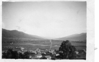
Photo - Bogong Township, September 1953
In 1940 Field Headquarters for the Kiewa Scheme were established at Bogong with office, workshop facilities and accommodation for workmen, staff and some families constructed. (There had been a 'tent camp' on this site in 1939 but was destroyed by bushfires) Construction of accommodation continued until 1947. A total of 40 houses plus a hostel for single staff, post office, police station, medical centre and primary school all with water and sewerage and electricity supply. The staff hostel was known as Kiewa House and is now occupied by the Education Department. Lake Guy was named after Mr. L.T. Guy who was the Resident Engineer in charge of construction work and associated activities on the Kiewa area. He held this position from 1939 to November 1946 when he was transferred to Head Office. The Bogong Township was developed firstly as an accommodation centre (base camp) for construction workers employed under the Kiewa Hydroelectric Scheme. Due to the influx of European workers into the Township the beautification of the immediate surrounds (gardens etc.) had a distinct European flavour. This environment has been very beneficial for tourism in later years. At the completion of the scheme, in the 1960's, the village was opened to public/tourism use. Strict environmental control has not allowed for any extensive redevelopment in tourist accommodation and basically restricted it to the accommodation initially built for the construction workers. Activities such a bike riding, snow skiing, restricted horse riding and bush walking on the Alpine plains and mountains are now a viable part of the Kiewa Valley Tourist Industry. The lake is one of the many water storage reservoirs used to supply the power stations their main power to run the huge turbines generating the final product, electricityBlack and white photograph of Bogong Township taken from Little Arthur fire track. September 1953Faded handwritten inscription on back - Bogong Township taken from Little Arthur fire track. Sept 1953bogong village, secv -
 Kiewa Valley Historical Society
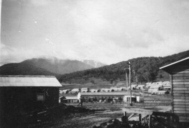
Photo - First Bogong Camp, September 1950
In 1940 Field Headquarters for the Kiewa Scheme were established at Bogong with office, workshop facilities and accommodation for workmen, staff and some families constructed. (There had been a 'tent camp' on this site in 1939 but was destroyed by bushfires) Construction of accommodation continued until 1947. A total of 40 houses plus a hostel for single staff, post office, police station, medical centre and primary school all with water and sewerage and electricity supply. The staff hostel was known as Kiewa House and is now occupied by the Education Department. Lake Guy was named after Mr. L.T. Guy who was the Resident Engineer in charge of construction work and associated activities on the Kiewa area. He held this position from 1939 to November 1946 when he was transferred to Head Office. The Bogong Township was developed firstly as an accommodation centre (base camp) for construction workers employed under the Kiewa Hydroelectric Scheme. Due to the influx of European workers into the Township the beautification of the immediate surrounds (gardens etc.) had a distinct European flavour. This environment has been very beneficial for tourism in later years. At the completion of the scheme, in the 1960's, the village was opened to public/tourism use. Strict environmental control has not allowed for any extensive redevelopment in tourist accommodation and basically restricted it to the accommodation initially built for the construction workers. Activities such a bike riding, snow skiing, restricted horse riding and bush walking on the Alpine plains and mountains are now a viable part of the Kiewa Valley Tourist Industry. The lake is one of the many water storage reservoirs used to supply the power stations their main power to run the huge turbines generating the final product, electricityBlack and white photo of Bogong Village. September 1950Handwritten on the back - 1st Bogong Camp. SEC Kiewa Scheme Sept 1950bogong camp, bogong village, secv -
 Kiewa Valley Historical Society
Photo - Bogong Village Township
In 1940 Field Headquarters for the Kiewa Scheme were established at Bogong with office, workshop facilities and accommodation for workmen, staff and some families constructed. (There had been a 'tent camp' on this site in 1939 but was destroyed by bushfires) Construction of accommodation continued until 1947. A total of 40 houses plus a hostel for single staff, post office, police station, medical centre and primary school all with water and sewerage and electricity supply. The staff hostel was known as Kiewa House and is now occupied by the Education Department. Lake Guy was named after Mr. L.T. Guy who was the Resident Engineer in charge of construction work and associated activities on the Kiewa area. He held this position from 1939 to November 1946 when he was transferred to Head Office. The Bogong Township was developed firstly as an accommodation centre (base camp) for construction workers employed under the Kiewa Hydroelectric Scheme. Due to the influx of European workers into the Township the beautification of the immediate surrounds (gardens etc.) had a distinct European flavour. This environment has been very beneficial for tourism in later years. At the completion of the scheme, in the 1960's, the village was opened to public/tourism use. Strict environmental control has not allowed for any extensive redevelopment in tourist accommodation and basically restricted it to the accommodation initially built for the construction workers. Activities such a bike riding, snow skiing, restricted horse riding and bush walking on the Alpine plains and mountains are now a viable part of the Kiewa Valley Tourist Industry. The lake is one of the many water storage reservoirs used to supply the power stations their main power to run the huge turbines generating the final product, electricityBlack and white photograph of Bogong Village from across Lake Guy. Photo mounted on buff cardbogong village, secv -
 Kiewa Valley Historical Society
Photograph - Mount Beauty from Bogong Hill, 1950
The new State Electricity Commission construction camp at the head of the Kiewa Valley was for workmen on the second power station in the project expected to be the most modern and best equipped in Australia… In contrast to the early Kiewa days of horses and canvas tents, the new camp, with its modern amenities, compared favourably with any country town. Administration of the Kiewa Scheme was moved from Tawonga to Mount Beauty in 1946. The first house in Mount Beauty, in Hollonds Street, was occupied by the co-op store manager from November 1946. The new Mess Hall at Mt Beauty was opened with much ceremony in early November 1946. The houses up to Nelse street were erected from 1946 onward and then the township was extended beyond Nelse Street in 1950. The workmen's camp was enlarged in 1950 to the extent of providing accommodation for a total of 1,200.Shows early construction of the town of Mt. Beauty surrounded by farmland taken in 1950 during the early stages of construction of the Kiewa Hydro electric SystemBlack and white photograph - aerial view of Mt Beauty taken from Bogong Hill. Photograph framed by 6mm white boarder.Handwritten on back of photograph in black ink - Mt Beauty from Bogong Hill 1950 Printed on rear Volox 2428mt beauty, bogong hill, secv -
 Kiewa Valley Historical Society
Photograph - Mount Beauty from second gate. View down Kiewa Valley, 1950
The new State Electricity Commission construction camp at the head of the Kiewa Valley was for workmen on the second power station in the project expected to be the most modern and best equipped in Australia… In contrast to the early Kiewa days of horses and canvas tents, the new camp, with its modern amenities, compared favourably with any country town. Administration of the Kiewa Scheme was moved from Tawonga to Mount Beauty in 1946. The first house in Mount Beauty, in Hollonds Street, was occupied by the co-op store manager from November 1946. The new Mess Hall at Mt Beauty was opened with much ceremony in early November 1946. The houses up to Nelse street were erected from 1946 onward and then the township was extended beyond Nelse Street in 1950. The workmen's camp was enlarged in 1950 to the extent of providing accommodation for a total of 1,200.Shows early construction of the town of Mt. Beauty surrounded by farmland taken in 1950 during the early stages of construction of the Kiewa Hydro electric SystemBlack and white photograph - View from second gate down Kiewa Valley showing early buildings. Photograph framed by 6mm white boarderHandwritten in back of photo in blue ink - View from second gate down Kiewa Valley 1950mt beauty, kiewa valley, secv -
 Kiewa Valley Historical Society
Photograph - Mount Beauty SEC Camp and Town, 1950
The new State Electricity Commission construction camp at the head of the Kiewa Valley was for workmen on the second power station in the project expected to be the most modern and best equipped in Australia… In contrast to the early Kiewa days of horses and canvas tents, the new camp, with its modern amenities, compared favourably with any country town. Administration of the Kiewa Scheme was moved from Tawonga to Mount Beauty in 1946. The first house in Mount Beauty, in Hollonds Street, was occupied by the co-op store manager from November 1946. The new Mess Hall at Mt Beauty was opened with much ceremony in early November 1946. The houses up to Nelse street were erected from 1946 onward and then the township was extended beyond Nelse Street in 1950. The workmen's camp was enlarged in 1950 to the extent of providing accommodation for a total of 1,200.Shows early construction in the town of Mt. Beauty surrounded by hills and farmland, with Mt Bogong in the background. Photo was taken in 1950 during the early stages of construction of the Kiewa Hydro electric SystemBlack and white photograph of Mt Beauty township in 1950 showing original workers buildings. Photograph has a .5cm white border around the photo.Handwritten on back of photograph in blue ink - SEC Camp and Town Mt Beauty 1950mt beauty, secv, mt beauty workmen's camp -
 Kiewa Valley Historical Society
Photograph - Mt Beauty Camp
The new State Electricity Commission construction camp at the head of the Kiewa Valley was for workmen on the second power station in the project expected to be the most modern and best equipped in Australia… In contrast to the early Kiewa days of horses and canvas tents, the new camp, with its modern amenities, compared favourably with any country town. Administration of the Kiewa Scheme was moved from Tawonga to Mount Beauty in 1946. The first house in Mount Beauty, in Hollonds Street, was occupied by the co-op store manager from November 1946. The new Mess Hall at Mt Beauty was opened with much ceremony in early November 1946. The houses up to Nelse street were erected from 1946 onward and then the township was extended beyond Nelse Street in 1950. The workmen's camp was enlarged in 1950 to the extent of providing accommodation for a total of 1,200.Shows early construction in the town of Mt. Beauty surrounded by hills and farmland, with a snow capped Mt Bogong in the background. Photo was taken in approximately 1950 during the early stages of construction of the Kiewa Hydro-electric SystemBlack and white photograph, mounted on corrugated cardboard. Photograph of Mt Beauty townshipHandwritten on back of photograph in blue pen - Permanent loan from Adrian Campan April 96 057-544043mt beauty camp, secv -
 Kiewa Valley Historical Society
Photograph – Set of 3 black and white photographs of Bogong Village circa late 1930's - 1940's during early construction of Lake Guy ( in the foreground), Late 1930's - 1940's
In 1940 Field Headquarters for the Kiewa Scheme were established at Bogong with office, workshop facilities and accommodation for workmen, staff and some families constructed. (There had been a 'tent camp' on this site in 1939 but was destroyed by bush fires) Construction of accommodation continued until 1947. A total of 40 houses plus a hostel for single staff, post office, police station, medical centre and primary school all with water and sewerage and electricity supply. The staff hostel was known as Kiewa House and is now occupied by the Education Department. Lake Guy was named after Mr. L.T. Guy who was the Resident Engineer in charge of construction work and associated activities on the Kiewa area. He held this position from 1939 to November 1946 when he was transferred to Head Office. The Bogong Township was developed firstly as an accommodation centre (base camp) for construction workers employed under the Kiewa Hydroelectric Scheme. Due to the influx of European workers into the Township the beautification of the immediate surrounds (gardens etc.) had a distinct European flavour. This environment has been very beneficial for tourism in later years. At the completion of the scheme, in the 1960's, the village was opened to public/tourism use. Strict environmental control has not allowed for any extensive redevelopment in tourist accommodation and basically restricted it to the accommodation initially built for the construction workers. Activities such a bike riding, snow skiing, restricted horse riding and bush walking on the Alpine plains and mountains are now a viable part of the Kiewa Valley Tourist Industry. The lake is one of the many water storage reservoirs used to supply the power stations their main power to run the huge turbines generating the final product, electricity3 black and white photographs of the Bogong camp area showing the clearing of trees for the construction of the Junction Dam and Lake Guy. Some administration buildings have been constructed, but part of the tent camp can be seen to the right of the photograph in front of the buildings. bogong village; junction dam; lake guy; kiewa hydro electric scheme; secv -
 Warrnambool and District Historical Society Inc.
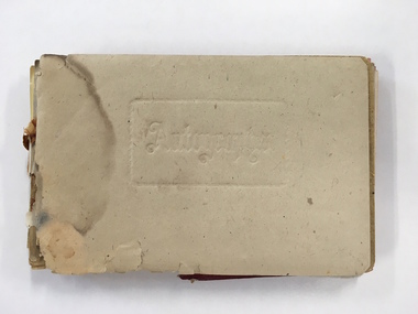
Booklet, Autograph Book, Late 1930s
According to the front page this autograph book belonged to Patricia Spencer of Spencer Street, Dartmoor. Dartmoor is a small settlement on the Princes Highway between Heywood and the South Australian border. It was first settled in the late 1850s and the main industry is the processing of timber from the surrounding pine plantations. Patricia Spencer attended Warrnambool High School in the late1930s and this album contains a number of entries from Warrnambool High School in 1938. It also has a page of eleven signatures of the Head Master, George Langley and other teachers from Warrnambool High School. There are also entries from people from Mortlake and Panmure and other entries with the person’s address not indicated. Autograph books such as this one were commonly owned by young people in the 19th and 20th centuries (up to about 1950) and were very popular with young girls.This album, although incomplete and tattered, is of interest because it is a good example of the social custom, more popular a couple of generations back than it is today, of young people owning and obtaining signatures and verses from their friends and acquaintances. It is also important because it contains signatures of Warrnambool High School teachers in 1938 and there are other entries of interest. This is a small autograph album that was originally bound with a cardboard cover with red leather backing but now has no front cover and only part of the back cover. The pages are all loose and the front section (buff-coloured) has a cardboard piece with felt padding. The pages are coloured in a variety of pastel tones and there are many handwritten entries of verses and signatures, with several from the ‘B’ Form, 1938, of ‘W.H.S. (Warrnambool High School). The album appears to have belonged to Patricia Spencer from Dartmoor. Some of the pages are torn and stained. At the back there are remnants of a sketch of an Asian scene and a letter to ‘Pat’ for her birthday. ‘Autographs’ ‘Patricia Spencer, Spencer Street, Dartmoor’ autograph albums, patricia spencer, warrnambool -
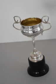 Warrnambool and District Historical Society Inc.
Trophy, ICISA CMI Rope Quoits 1937, 1937
This trophy is one of several from the 1930s awarded as part of the Warrnambool inter-church indoor sports competitions. One of the sponsors of this competition was Fletcher Jones, the well-known clothing manufacturer. He had his head office and main factory in Warrnambool. This trophy was awarded for rope quoits. The game of quoits consists of competitors throwing four or five rings or hoops on to a raised spike some metres away. The hoops are generally made of plaited rope and the game is said to have been started or popularized by sailors on board ship. The trophy was won by the Congregational Men’s Institute (C.M.I.). A Congregational Church was opened in Liebig Street in Warrnambool in 1864 and was transferred to Henna Street in 1940. This church was sold to the Salvation Army in 1979 when the Congregational Church merged with the Methodist Church to form the Uniting Church. This cup is of interest as it is a 1930s trophy awarded by the now-defunct Inter Church Indoor Sports Association of Warrnambool. This is an electro plated nickel silver cup with two ornate side handles and a stem in a bulbous shape attached to a silver base. The cup is mounted on a Bakelite stand.‘Inter Church Indoor Sports Association Cup Won by C.M.I. Rope Quoit Champions 1934’congregational church warrnambool, inter church indoor sports association warrnambool, history of warrnambool -
 Ballarat Clarendon College
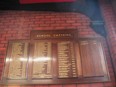
Honour board, Ballarat College School Captains
This was the second honour board created by Ballarat College to honour the school captain for each year. The first award was given in 1914. Prior to the time the captain of the football first was recognised as captain of the school. At amalgamation (1974) and because the Senior students moved to the Mair Street campus) this board was co-opted to honour Junior School captains. In 2012 the school undertook a major project and created three new boards. One board honours Ballarat College Dux (1868 - 1973) and School Captains (1914 - 1973); another board honours Clarendon Presbyterian Ladies' College Dux and Head Prefect (1919 - 1973). These boards resemble the 1950 re-creation. A third board was instituted in 2012 to honour Ballarat Clarendon College Dux and School Captains (1974 - ) This board emphasizes the value placed on leadership by the school from its earliest beginnings. That the boards have been maintained and consistently displayed in significant places of honour within the school only further emphasizes the historial and social significance of the award 'school captain'. Large varnished wooden board with wood frame, four rectangular relief boards and one heading relief board. Gold leaf lettering on relief boards.ballarat-college, school-captains, honour-boards, memorial-hall, junior-school-captain, -
 Federation University Historical Collection
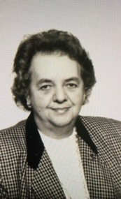
Article - Article - Women, University of Ballarat: Women of Note; Heather Durant, Librarian at SMB, 1951-2005. (1933-2009)
Heather Durant (nee Walton) began as an Assistant Librarian at the SMB Campus in 1951. In December 1961 she resigned from the position due to her approaching marriage. No replacement was found so she returned in a "part-time position". She progressed to head librarian. Heather resigned again in 1962 and took a break for eight years. She then returned to the school. Combining the two periods of work she was employed for almost 50 years. During her time with the University of Ballarat she made an important contribution to the operation of the SMB Library. At times she was put in charge and worked to maintain library standards and collections through her work in library acquisitions and cataloguing. Over the years she witnessed the changes that occurred when technology was introduced and the growth of the University and TAFE divisions.women of note, teacher, ballarat school of mines, heather walton, heather durant, smb campus, librarian, resigned to marry, part-time work, library standards, and collections, acquisitions and cataloging, technology, 50 years service, 1951-2005 -
 Flagstaff Hill Maritime Museum and Village
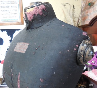
Equipment - Mannequin, J. A. Walker, before April 1874
THE MANNEQUIN The included wooden mannequin made by J.A. Walker of Melbourne has been very well used, as can be seen from the pin marks and split and torn fabric in areas where pins would have been used many times. The painted wood of the bodice is wearing away. The top of the neck is very rough in the centre, indicating that it possibly had a knob, handle or even a head shape on top. The mannequin could have been used for storing and cleaning of the evening outfit and even in the process of making it. It is made to match the measurements of the outfit beautifully and would be close in measurement to Mrs. Isabella Mitchell. Isabella’s sister-in-law Eliza Russell made her own wedding dress and perhaps she or Isabella herself made the evening outfit using the mannequin for fittings. The mannequin is significant as its size gives an image of the shape of the evening outfit’s owner. It is also significant as an example of the process and skills to create garments of fashion during the period, with many people making their own garments. The mannequin is also an example of an item manufactured in Melbourne in colonial times. This wooden display mannequin is from neck to floor length. It has a round pedestal. The mannequin’s bodice has been painted black. It is padded then covered in black fabric. The maker of the mannequin was J.A. Walker of Melbourne. It dates to the mid-late 19th century.Mannequin maker’s fabric label “J.A. WALKER / MANUFACTURER / MELBOURNE”mannequin wooden, mannequin made in melbourne, dressmaker’s mannequin, 19th century mannequin, dress form, display mannequin, custom made mannequin, dressmaker’s dummy, andique mannequin, clothing display, j.a. walker manufacturer melbourne, j.a. walker mannequin manufacturer, evening outfit -
 Halls Gap & Grampians Historical Society
Photograph - B/W, C 1934
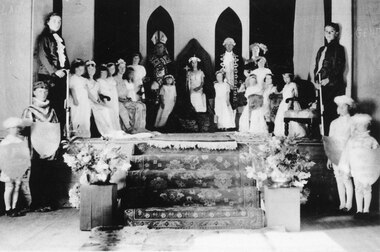
This is a photo of the "Queen Competition", probably the best remembered entertainment of the 1930's. Four local lasses were chosen to represent the following: Bellfield Hotel, Grampians House, The Cricket Club and the Grampians Mountains. When the long awaited evening came each Queen and her attendants paraded through the hall, the results were announced and the winner (who this year was Valerie Evans) took her place on a throne erected in the middle of the stage. The other Queens made their way to thrones on either side of her. The audience were treated to a right royal display as the "Bishop" placed a crown on the winner's head. Much merriment followed including a play, with students dressed as Minnie and Mickey Mouse and other Disney characters. For the names of the people in the photo refer to "Bridging the Gap" by Ida Stanton, p.88. The photo shows a group of people arranged on and below a dais. There is a woman dressed as royalty sitting on a throne in the centre, flanked by a man dressed as a bishop on the left and a man dressed as a courtier on the right. There are two young girls in long white dresses wearing flowered bands in their hair standing in front of the men. There are more girls in white dresses and flower bands along both sided of the dais and two youths wearing ruffle fronted shirts and holding batons/walking sticks(?) at the front of each row of girls. Carpeted steps lead down from the dais and in front of the dais on either side are two boys dressed as pages. Flower arrangements flank the foot of the stairs.recreation, entertainment -
 Kiewa Valley Historical Society
Photograph from Lake Guy, Bogong Village, Scene from shores of Lake Guy to Mountain range, 1930s to 1950s
In 1940 Field Headquarters for the Kiewa Scheme were established at Bogong with office, workshop facilities and accommodation for workmen, staff and some families constructed. (There had been a 'tent camp' on this site in 1939 but was destroyed by bushfires) Construction of accommodation continued until 1947. A total of 40 houses plus a hostel for single staff, post office, police station, medical centre and primary school all with water and sewerage and electricity supply. The staff hostel was known as Kiewa House and is now occupied by the Education Department. Lake Guy was named after Mr. L.T. Guy who was the Resident Engineer in charge of construction work and associated activities on the Kiewa area. He held this position from 1939 to November 1946 when he was transferred to Head Office.The Bogong Township was developed firstly as an accommodation centre (base camp) for construction workers employed under the Kiewa Hydroelectric Scheme. Due to the influx of European workers into the Township the beautification of the immediate surrounds(gardens etc.) had a distinct European flavour. This environment has been very beneficial for tourism in later years. Strict environmental control has not allowed for any extensive redevelopment in tourist accommodation and basically restricted it to the accommodation initially built for the construction workers. Activities such a bike riding, snow skiing, restricted horse riding and bush walking on the Alpine plains and mountains are now a viable part of the Kiewa Valley Tourist Industry. The lake is one of the many water storage storage reservoirs used to supply the power stations their main power to run the huge turbines generating the final product, electricityThis black and white photograph shot from the shores of Lake Guy toward the mountain range of the Victorian Alps details the early construction of the construction worker's accommodation of the Bogong Village. The paper is of 200gms and is not photographic paper and can be assumed to be a reproduction of an original photobogong village circa 1930 to 1950, kiewa hydro-electricity scheme, victorian alpine region mid 1900s -
 Kiewa Valley Historical Society
Photograph of Lake Guy and Bogong Village, Lake Guy and Bogong Village, Approx. 1945
In 1940 Field Headquarters for the Kiewa Scheme were established at Bogong with office, workshop facilities and accommodation for workmen, staff and some families constructed. (There had been a 'tent camp' on this site in 1939 but was destroyed by bushfires) Construction of accommodation continued until 1947. A total of 40 houses plus a hostel for single staff, post office, police station, medical centre and primary school all with water and sewerage and electricity supply. The staff hostel was known as Kiewa House and is now occupied by the Education Department. Lake Guy was named after Mr. L.T. Guy who was the Resident Engineer in charge of construction work and associated activities on the Kiewa area. He held this position from 1939 to November 1946 when he was transferred to Head Office.This photograph is an excellent historical record of Bogong Village in about 1945. It shows the layout of the town in the fairly steep terrain, the workmen's camp between the houses and the lake foreshore, the Commissioner's Lodge on the hill behind the Village, the walkway through the dam wall can be seen to the left of the spillway, the dam is on spill and note damage to the large trees is still evident from the 1939 bush fires. The Commissioner's Lodge was lost in the 2003 fires and the camp buildings were in service until 1962, when they were removed and the site converted into a public picnic area with lawns and gardens.A Black and white photograph"Lake Guy and Bogong" hand written on back of photograph.kiewa, accommodation, lake, dam, bogong -
 Eltham District Historical Society Inc
Negative - Photograph, The Leader, Relics of the Old Mining days in the Queenstown District, 2 Nov 1929
Queenstown (St. Andrews) District. Originally published in The Leader, Nov. 2nd, 1929, p30, with the title "Relics of the Old Mining days in the Queenstown District," a series of seven numbered photographs with captions : 1. Two Old-Timers, Brothers Tom and Alex McPhee, Camped on Back Creek. 2. Like the Caledonia, Every Yard of Queenstown Creek has been Washed. 3. Poppet Heads of the Caledonia Mine. 4. A Warning to Possible Land Buyers or Encouragement to Prospectors? 5. Mr. A. Harvey has been Prospecting the District, Washing a Loam, for Some Years. 6. John Olsen, of Smith's Gully, an Old-Timer, who is Shortly Going to Norway to Claim an Inheritance. 7. Queenstown Cemetery. - The Hills Form a Splendid Memorial to Many a Digger.This photo forms part of a collection of photographs gathered by the Shire of Eltham for their centenary project book,"Pioneers and Painters: 100 years of the Shire of Eltham" by Alan Marshall (1971). The collection of over 500 images is held in partnership between Eltham District Historical Society and Yarra Plenty Regional Library (Eltham Library) and is now formally known as the 'The Shire of Eltham Pioneers Photograph Collection.' It is significant in being the first community sourced collection representing the places and people of the Shire's first one hundred years.Digital image 4 x 5 inch B&W Negsepp, shire of eltham pioneers photograph collection, queenstown, gold mining, a. harvey, alex mcphee, back creek, caledonia mine, john olsen, poppet heads, queenstown cemetery, queenstown creek, smiths gully, st. andrews, tom mcphee -
 Orbost & District Historical Society
program, 1953
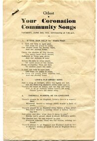
This program was produced by the Snowy River Mail for a community singalong held in Orbost on Tuesday June 2 1953 to celebrate the coronation of Queen Elizabeth 11. In June 1953 , Elizabeth II was crowned Queen of the United Kingdom, Canada, Australia, New Zealand, South Africa, Ceylon (now Sri Lanka), and Pakistan, and became the Head of the Commonwealth. The coronation of Queen Elizabeth II as monarch took place on 2 June 1953. Elizabeth ascended the throne at the age of 25, upon the death of her father, King George VI, on 6 February 1952, and was proclaimed queen by her various privy and executive councils shortly afterwards. The coronation took place more than a year later because of the tradition that holding such a festival is inappropriate during the period of mourning that follows the death of a monarch. This community event was typical of the general feeling of respect and admiration felt by the rural communities towards the British Royal Family. This item reflects the significance of monarchy for Australia and the constitutional history of Australia.The item reflects the interest in the royal family to Australians at this time as well as the general feeling of respect and admiration felt by the rural communities towards the British Royal Family.A white paper program with the words of songs printed in black. There is a rust mark from a metal staple in the top left corner. It is titled "Your Coronation Community Songs".queen-elizabeth-11 royalty community-event-orbost souvenir-program -
 Orbost & District Historical Society
minute book, from November 20, 1928
Brodribb State School was State School 3635. It is now on the grounds of the Primary School at Orbost. The schoolopened on 1st of January 1910. It consisted of a building constructed by the parents of the children concerned. This early structure was leased to the Department which had refused requests by the parents to provide a school. This arrangement persisted until 1950. The first Head Teacher was Hubert E. Neville who served there from 1st of January 1910 to 7th of July 1910. In 1950 the Jarrahmond School building was moved to Brodribb, and provided much improved facilities for the teacher and pupils. This building remained in use until 1965 when the school closed because of insufficient numbers. The Brodribb School remained vacant until 1968, when, moved to Orbost, it became an integral part of the school in Ruskin Street Orbost. This school record is of immediate interest and value to the pupils and staff who have learned and taught in the Brodribb State School. The record also has a much wider significance, to the community in which the school is situated, as a record and research tool.Hand - written minutes of the Brodribb State School Committee. They are bound together but with no cover. The writing is in black ink.brodribb-state-school-history -
 Orbost & District Historical Society
black and white photograph, 1962
This photo shows Bert May addressing a group of ladiers at the 1962 Golden Jubilee of the Orbost High School. Bert May served as the Member for Gippsland in the Legislative Council from 1957 until 1973. With earlier levels of schooling available at the Orbost State School or nearby schools of Newmerella and Jarrahmond School, it was not until April 1912, and after much campaigning from parents and other notable community members, that the Orbost Higher Elementary School was opened. Mr Richard Trembath was appointed the new Head teacher of Orbost Higher Elementary School and was assisted by Miss Olga Hirst. The senior class consisted of 26 pupils, and the junior class, 16 pupils. A limited curriculum was available which included lessons in Latin, Arithmetic, Algebra, Geometry, Geography, History, Drawing and advanced English. (ref. O.S.C. website)Orbost High School / Orbost Secondary College has played a significant part in the education of senior students in the Orbost district . It is the sole senior educational institution. This item is representative of its history and is a useful reference tool.A black / white photograph of a man giving a speech to a group of ladies in a classroom. all are standing.on back - Bert May, Orbost H.S. Jubilee 1962orbost-education orbost-high-school -
 Orbost & District Historical Society
black and white photograph, 1962
This photograph was taken at the Golden Jubilee of Orbost High School in 1962. Bert May is addressing crowds. Bert May served as the Member for Gippsland in the Legislative Council from 1957 until 1973. With earlier levels of schooling available at the Orbost State School or nearby schools of Newmerella and Jarrahmond School, it was not until April 1912, and after much campaigning from parents and other notable community members, that the Orbost Higher Elementary School was opened. Mr Richard Trembath was appointed the new Head teacher of Orbost Higher Elementary School and was assisted by Miss Olga Hirst. The senior class consisted of 26 pupils, and the junior class, 16 pupils. A limited curriculum was available which included lessons in Latin, Arithmetic, Algebra, Geometry, Geography, History, Drawing and advanced English. (info. from O.S.C. website.Orbost High School / Orbost Secondary College has played a significant part in the education of senior students in the Orbost district . It is the sole senior educational institution. A black / white photograph of Mr Bert May, on a stage, addressing an audience, most seated, some standing behind him.back - hand-written - "Orbost H.S. Jubilee, 1962 - Bert May".orbost -education orbost-high-school -
 Orbost & District Historical Society
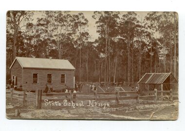
black and white photograph, 1908
This item is part of the Mary Gilbert Collection. Noorinbee School, situated on the Bombala Rd approximately 6.5 km north of Cann River, was opened on 26th of July 1900, with Albert Le Page as head teacher until 30th of September 1904. The school no longer functions. A school bus would daily to take the older children to the central classes at Cann River. "Noorinbee" is an Aboriginal word of unknown origin, The historical school is still at the front of the school yard. The Old Noorinbee School was been shifted twice. The first time they used a bullock team in 1924. The second time they used trucks and tractors in 1991. It was the first public building for the Cann Valleyand was first used as a hall and a church until it became the Noorinbee school in 1900. It was built in 1898.This item is associated with education in East Gippsland. It is also associated with the Gilbert family.A black / white photograph / postcard which has a letter written on the back. On the front is a small wooden building, a shed on the right, a wooden fence at the front with children scattered in the yard.on front - "State School No 3372" on back - " Mrs J. Gilbert Talangoota, Orbost"gilbert-annie noorinbee-state-school education-east-gippsland -
 Orbost & District Historical Society
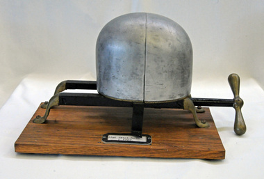
hat stretcher, first half 20th century
Prior to the 1960s, hats were worn by all men. Aluminium hat stretchers were generally in use from the 1920’s. The hat was placed on the aluminium dome shaped piece. When the handle was turned, the dome section split vertically, one section moving away from the fixed half. A graduated scale along the side indicated the size. This item was possibly used in the hat factory in Orbost. Stuart Hats commenced manufacturing hats in about 1948 and closed their factory in Orbost around 1953 probably because of the high transport costs. The company's head factory was in Melbourne. The hats made in Orbost were sold all over Australia as well as in Melbourne at Myers and David Jones. The building became first a Dry Cleaners and then a private home.This item was possibly used by Stuart Hats which was a significant manufacturing business in Orbost in the 1950's employing nearly 20 local people.A hat stretcher consisting of an aluminium dome-shaped piece (on which the hat was placed) and a metal winder. It has been mounted onto a wooden baseOn wooden base : "Restored by John Mundy"millinery hats hat-stretcher -
 Glen Eira Historical Society
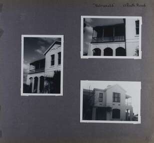
Album - Album page, Balranald, Poath Road, Circa 1972
This photograph is part of the Caulfield Historical Album 1972. This album was created in approximately 1972 as part of a project by the Caulfield Historical Society to assist in identifying buildings worthy of preservation. The album is related to a Survey the Caulfield Historical Society developed in collaboration with the National Trust of Australia (Victoria) and Caulfield City Council to identify historic buildings within the City of Caulfield that warranted the protection of a National Trust Classification. Principal photographer thought to be Trevor Hart, member of Caulfield Historical Society. Most photographs were taken between 1966-1972 with a small number of photographs being older and from unknown sources. All photographs are black and white except where stated, with 386 photographs over 198 pages. Originally named Crofthead or The Croft Head, later changed to Balranald according to Melbourne Mansions database.From Victorian Heritage Database citation for HO136 13 Poath Street MURRUMBEENA https://vhd.heritagecouncil.vic.gov.au/places/35389 as at 30/10/2020 "Croft Head" is situated at no. 13 Poath Road, Murrumbeena, and was built in 1887 for the accountant Edward Tweddell. It is historically and aesthetically significant. It is historically significant (Criterion A) as a substantial and now rare (Criterion B) surviving late Victorian villa residence east of Booran Road within the Municipality and demonstrating the attraction of Melbourne's rural fringe as a residential location rendered accessible by the opening of the railway between South Yarra and Oakleigh in 1879. It is aesthetically significant (Criterion E) as one of the Municipality's finest late Victorian polychrome brick villas, comparing with ''Fresch'' and ''Monkleigh'' both erected in 1899 at nos. 11 and 12 Gladstone Parade, Elsternwick respectively, ''Hartington'' (1888) at 15 Gladstone Parade and ''Hengar'' (1889) at no. 356 Glen Eira Road, Caulfield South. Elements of stylistic significance include the ornamentation of the brickwork in polychrome work with tiled panels, the effect of the banding being especially striking and representative of the period.Page 166 of Photograph Album with three photographs of Balranald on Poath Road.Handwritten: "Balranald" 13 Poath Road [top right] / 166 [bottom right]trevor hart, decorative brackets, chimneys, verandah, porch, poath road, arches, cast iron columns, return verandah, croft head, balranald, victorian villa, restoration, 1880's, edward tweddell, murrumbeena, hughesdale, cast iron frieze, victorian style, cast iron work, rendered brick, house names, polychrome brick, poath street, crofthead, the croft head -
 Federation University Historical Collection
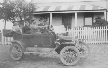
Photograph, Harold Hauson, Members of the Wright family outside "Laura Villa" Smeaton, (estimated); early 1930's
In 1860 Smeaton residents appealed for funds to establish a school. Patrick Curtain, and his co-workers raised more than £150 plus a land grant (Allot A, Sect 2, Township of Smeaton). Head Teacher John Forbes, with assistant Zillah North, opened a timber school building which measured 36ftx18ft (11.0x5.5m) on 1 September 1861 with 44 children. Rising enrolment to 65 in 1868 made building alterations necessary. During 1870-1 a residence of four rooms was supplied and in October 1882 a 20ftx18ft (6.1x5.5m) classroom. In 1907 a new brick building accommodated 122 children. Among notable ex-pupils are Major-General Bridgeford, Frank Wright ( Musical Director of the London County Council), Alex Wright, (AKA singer Andre Navarre), and Les Brooks. (Visions and Realisations) Sepia photograph showing 4 people sitting in a 1914 Ford Model T Touring Car outside The Wright Familys' "Laura Villa" property at Smeaton. Left hand back seat - Mrs W. Wright, Mrs Kelso Front seat: F.L.Redman (driving), W. WrightTaken at "Laura Villa" Smeaton by Harold Hausenfrank wright, laura villa, smeaton, car, 1914 ford model t touring car -
 Federation University Historical Collection
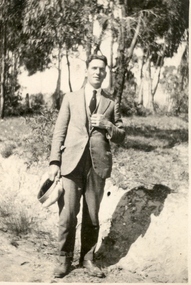
Photograph - Photo, Bill Fargher, Frank Wright at Daylesford, 1/1/1924 (exact); 1924
In 1860 Smeaton residents appealed for funds to establish a school. Patrick Curtain, and his co-workers raised more than £150 plus a land grant (Allot A, Sect 2, Township of Smeaton). Head Teacher John Forbes, with assistant Zillah North, opened a timber school building which measured 36ftx18ft (11.0x5.5m) on 1 September 1861 with 44 children. Rising enrolment to 65 in 1868 made building alterations necessary. During 1870-1 a residence of four rooms was supplied and in October 1882 a 20ftx18ft (6.1x5.5m) classroom. In 1907 a new brick building accommodated 122 children. Among notable ex-pupils are Major-General Bridgeford, Frank Wright ( Musical Director of the London County Council), Alex Wright, (AKA singer Andre Navarre), and Les Brooks. (Visions and Realisations) Frank Wright, aged 22, in a bush location at Daylesford - possibly at a mineral water spring.frank wright, daylesford