Showing 1803 items
matching a. farrer
-
 Ararat & District Historical Society (operating the Langi Morgala Museum)
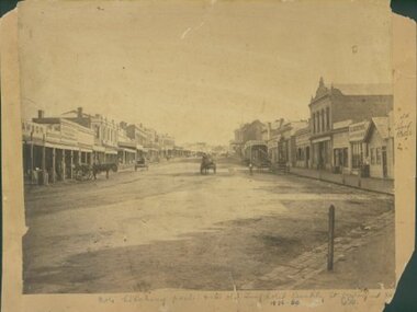
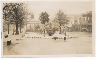
Barkly Street, Ararat, perhaps 1870s
This is one of a dozen or so pictures of very early Ararat held by Langi Morgala Museum, and can be compared to a succession of later photographs to illustrate the growth of the town of Ararat. The date suggested by the inscription on the front is probably a reference to some other occurrence, since the street seems far to built-up for 1856-1860. The date is more likely the 1870s, or even the 1880sThis photograph, though not in good condition, is one of the few in the possession of Langi Morgala Museum that shows very early Ararat. It is of regional significance, which would be enhanced if a firmer date could be established. This cardboard-mounted large photograph is not in very good condition, but some parts of the image are still clear. There are permanent inscriptions on both front and back, not done in sympathy with the age and importance of the item.On front: "Note hitching posts and the old Turf Hotel, Barkly Street cont[illegible] / 1856-60". On back: museum stamp and photo numbers.barkly-street, ararat, horse, horse-driven, early-ararat, business, commercial -
 Melbourne Legacy
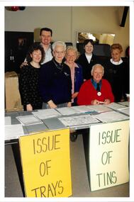
Photograph - Photo, Legacy Appeal 2000, Preparing for Badge Week, 2000
A photo of a group of Legacy Staff, volunteers and Legatees, preparing for the issuing of Badge Trays and Legacy Appeal tins in a room of Legacy House. Staff members Karen Tillotson and Brett Tillotson are on the left, third from left is Glad Fenton, a legacy widow, and on far right is Dulcie Cedaro. The film number is very close to that of 00533 so it is assumed to be September 2000.A record of fundraising.Colour photo of volunteers and staff getting ready for Badge Week.Printing on the back "legacy appeal, fundraising, badge week -
 Vision Australia
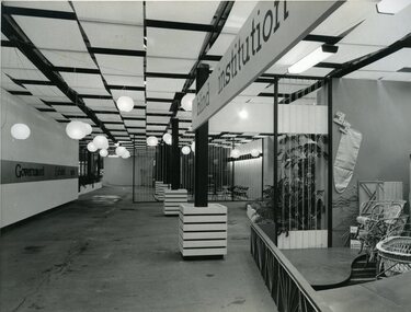
Photograph - Image, Queensland Blind Institution display at exhibition, 1962?
Part of a display by the Queensland Blind Institution (?) as part of a exhibition. Neither the full name of the organisation nor the exhibition are known, however a sign on the opposite wall reads "Government Exhibit 1962". Cane chairs, an ironing board cover, coat hangers, a cane cot and a cane screen are viewable to the far right of the image. The remaining view is of an empty space awaiting exhibitors.1 x B/W photograph of exhibition spaceC2-4138 Reproduced by Photo Section, Survey Office, Dept. Public Lands, QLD.queensland industrial institute for the blind, fundraising -
 Bacchus Marsh & District Historical Society
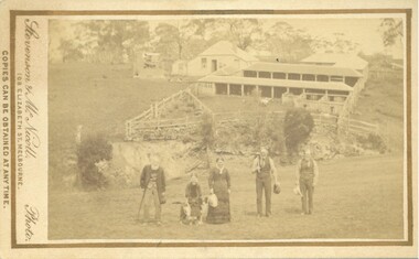
Photograph, 'Plainside' Home and Farm of George Dickson Bacchus Marsh 1883
This property was located near Bacchus Marsh not far from the Racecourse. The photo shows members of the Dickson family. The oldest man on the left is possibly George Dickson who died in 1885 aged 92. The man second from the right is possibly the younger George Dickson who died aged 77 in 1900. The girl or the woman in the image is possibly Margaret Dickson.Small sepia unframed photograph on card with gold border framing photograph. Housed in the album, 'Photographs of Bacchus Marsh and District in 1883 by Stevenson and McNicoll'. In the foreground of the image are members of the Dickson family. In the background are yards, farm sheds, which are possibly milking sheds. Behind the sheds is the family home.On the front: Stevenson & McNicoll. Photo. 108 Elizabeth St. Melbourne. COPIES CAN BE OBTAINED AT ANY TIME. On the back: LIGHT & TRUTH inscribed on a banner surmounted by a representation of the rising sun. Copies of this Portrait can be had at any time by sending the Name and Post Office Money Order or Stamps for the amount of order to STEVENSON & McNICOLL LATE BENSON & STEVENSON, Photographers. 108 Elizabeth Street, MELBOURNE. stevenson and mcnicoll 1883 photographs of bacchus marsh and district, dickson family bacchus marsh, farmers, farms bacchus marsh -
 Wodonga & District Historical Society Inc
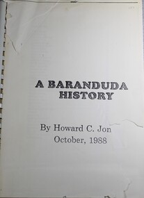
Book - A Baranduda History, Howard C Jones, 1988
A history of Baranduda in Northeast Victoria. Baranduda is a rural area and, since the 1970s, a rural and residential locality formed under the authority of the Albury Wodonga Development Corporation. It is near the junction of Yackandandah Road and the Kiewa Valley Highway, 10 km south-east of Wodonga. This publication traces the history of the area from its earliest know indigenous inhabitants, through the days of the earlier establishment of pastoral runs to more recent developments.Spiral boundnon-fictionA history of Baranduda in Northeast Victoria. Baranduda is a rural area and, since the 1970s, a rural and residential locality formed under the authority of the Albury Wodonga Development Corporation. It is near the junction of Yackandandah Road and the Kiewa Valley Highway, 10 km south-east of Wodonga. This publication traces the history of the area from its earliest know indigenous inhabitants, through the days of the earlier establishment of pastoral runs to more recent developments.baranduda, pioneers victoria, huon family, wodonga pioneers -
 Vision Australia
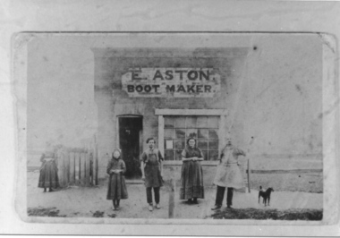
Photograph - Image, Aston family outside Boot Maker shop, 1870s
Members of the Aston family in front of Tilly’s father’s boot making business in Carisbrook, where Tilly was born in 1873. From left: Sophie Aston (Tilly’s sister), William Aston (Tilly’s brother), Ann Aston (Tilly’s mother) and Edward Aston (Tilly’s father) and dog. The female figure on the far left of the image is unidentified. This image is a copy of a copy, and not the original.1 x b/w photograph of four people outside a shoptilly aston, edward aston, ann aston, william aston, sophie aston -
 Melbourne Tram Museum
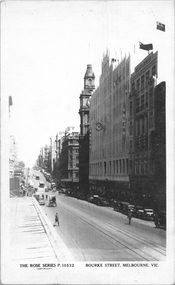
Postcard, Rose Stereograph Co, "Bourke Street Melbourne", c1935
Rose Series postcard No. P 10532 titled "Bourke Street Melbourne", looking west from near Swanston Street. Has two cable trams in the far distance. The Myer Emporium building is shown along with the GPO. A building crane can be seen on the left side of the photograph where Diamond House is under construction for Dunklings which was completed in 1936.Yields information about Bourke Street c1935Postcard - printed real photograph with Rose Stereograph Co. name on the rear.trams, tramways, cable trams, bourke st -
 Melbourne Tram Museum
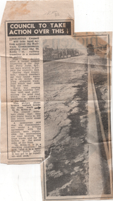
Newspaper - "Council to take action over this", Herald Sun, 1955
The article and photo reports on the poor condition of the Victorian Railways operated St Kilda to Brighton tram line in St Kilda St, Brighton. This section of line closed during 1957. The Council reported that it had briefed a QC about the matter. The Railways were responsible for road maintenance and track maintenance. The donor, noted that it is tram 32 in the far distance.Yields information about the condition of the St Kilda St Brighton prior to the tramway closure.Newspaper clipping titled - "Council to take action over this" - Melbourne Sun 21/7/1955"Melb "Sun" Thurs 21 July 1955 inside page 9"trams, tramways, vr trams, st kilda st, brighton, track maintenance, tram tracks -
 Bacchus Marsh & District Historical Society
Map, Plan of Survey of Part of Crown Allotment 9, Parish of Korkuperrimul, 1890
This map documents a transfer of an allotment of land in Clarke Street Bacchus Marsh in 1890. Clarke Street is located on the eastern side of Bacchus Marsh not far from Main Street and Crook Street. It is now known as Candeloro Street. The map indicates J. Booth as the owner of the land and H. Simpson as the occupier. Next to this allotment is a an allotment of land owned by J. Elmore,Single page map showing Crown allotment 9, Parish of Korkuperrimul, County of Bourke. Scale 100 feet to inch. Part of a set of maps which are pasted into a bound volume containing 76 maps or plans in total. High resolution digital image stored on BMDHS computer network. At bottom of map: I hereby certify that I have made this survey expressly for the purpose of an application under the Transfer of Land Statute that this plan is correct. Barry B???, Lic. Surveyor, 16.10.90bacchus marsh victoria maps, clarke street bacchus marsh maps -
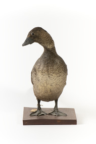 The Beechworth Burke Museum
Animal specimen - Musk Duck, Trustees of the Australian Museum, 1860-1880
This particular Musk Duck is a female specimen. This is ascertained through the lack of a large bulbous lobe of skin hanging under the bill. This particular duck has a much smaller lobe on the underside of its bill which is only visible when close. The name Musk Duck comes from the strong musk odour produced from a gland on the rump of the bird. These ducks are found only in Australia, in south-western and south-eastern mainland and in Tasmania. They prefer to reside in locations which have deep water and plenty of aquatic vegetation. This specimen is part of a collection of almost 200 animal specimens that were originally acquired as skins from various institutions across Australia, including the Australian Museum and the National Museum of Victoria, as well as individuals such amateur anthropologist Reynell Eveleigh Johns between 1860-1880. These skins were then mounted by members of the Burke Museum Committee and put-on display in the formal space of the Museum’s original exhibition hall where they continue to be on display. This display of taxidermy mounts initially served to instruct visitors to the Burke Museum of the natural world around them, today it serves as an insight into the collecting habits of the 19th century. This specimen is part of a significant and rare taxidermy mount collection in the Burke Museum. This collection is scientifically and culturally important for reminding us of how science continues to shape our understanding of the modern world. They demonstrate a capacity to hold evidence of how Australia’s fauna history existed in the past and are potentially important for future environmental research. This collection continues to be on display in the Museum and has become a key part to interpreting the collecting habits of the 19th century.A large duck with a sooty-brown plumage and paler brown colouring on the stomach and areas of the neck. This bird stands with its head turned to look over its right shoulder. The eyes are made of brown coloured glass. The legs on the Musk Duck are positioned towards the far back of the stocky body and the feet are webbed. This enables the duck to swim but provides a clumsy gait. The bill of this Musk Duck is dark grey and the tail feathers are positioned in a fan-shape.Paper tag reading "9a Musk Duck. See Catalogue, page, 39."taxidermy mount, taxidermy, animalia, burke museum, beechworth, australian museum, skin, reynell eveleigh johns, duck, musk duck, aquatic, biziura lobata -
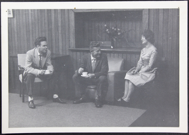 Mission to Seafarers Victoria
Photograph - Photograph, Black and white, 1955 - 1965
Photograph taken in the Celia Little Room at Mission to Seafarers Melbourne. The Celia Little Room was named in honour of the aunt of one of the serving (and resident) chaplains. The room is a multi-function room, being used at times for banquets or, as the photograph shows, for relaxation, by visiting seafarers.The age of the photograph consolidates the history of the Mission to seafarers. The people in the photograph are drinking hot beverages, sitting and chatting in a relaxed environment which is significant to the services provided by the Mission.Black and white photograph of two men and one woman seated in the Celia Little Room at the Mission to Seafarers.The man on the far left is wearing a light coloured sports coat and trousers, holding a cup and saucer. The man in the middle is wearing a dark suit, holding a cup and saucer. The woman is on the right and also seated, wearing a dress. Pin holes have been placed in the top corners of the photograph. Dated between late 1950s and early 1960s."8940" faded stamp on back of photograph.dress, suit, 1950s, 1960s, victorian-seamens-mission, cup-and-saucer, sports-coat, armchairs, seamen's mission, mission to seafarers, seamen, seafarers, sailors, lhlg, flying angel, celia little room, flinders street, melbourne, men, woman, social -
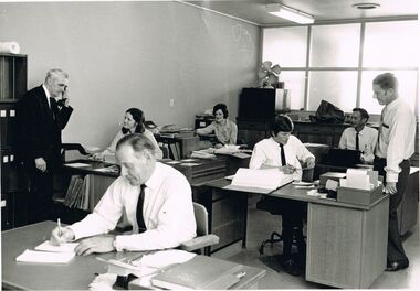 Bendigo Historical Society Inc.
Photograph - CASTLEMAINE GAS COMPANY COLLECTION: PHOTO PEOPLE
Date and Location Unknown - Photo of an Office with from Left to Right: Jim Holland (Ledgers Head on phone) - Bob Palmer (Cashier Foreground) - Judy Browell (Ledger Keeper looking up at J.Holland) - Jennifer Trimble (Typist ) - Tony Smith (Junior Clerk) - Bob Hillman (Sales Representative at Rear Sitting at Desk) - Bill Fuzzard (Sales Representative Standing far Right). On Back Stamp: Photography by Gas & Fuel Corporation Printing Section.business, retail, gas and fuel office -
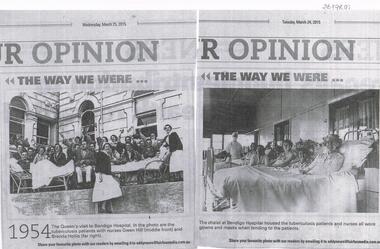 Bendigo Historical Society Inc.
Newspaper - BENDIGO SANATORIUM: NEWSPAPER ARTICLE PHOTOS
Two photocopies of photos, published in the Bendigo Advertiser's series "The Way We Were" on March 24 and 25th , 2015. Photo LH side of paper shows '1954, The Queen's visit to Bendigo Hospital. In the photo are the tuberculosis patients with nurses Gwen Hill ( middle front ) and Brenda Hollis ( far right). Other photo 'The Chalet at Bendigo Hospital housed the tuberculosis patients and nurses all wore gowns and masks when tending to the patients'bendigo, hospital, sanatorium -
 Port Melbourne Historical & Preservation Society
Plan, A J Duncan, Draughtsman, Plans and Sections of Tramsway, May 1891
Plans and typeset descriptions of a proposal to run a cable tram under the Yarra from Williamstown to Melbourne (Falls Bridge) via Port Melbourne. Oriniginally submitted to Victorian Legislative Assembly 1889; this updated 1891 version has 10 pages, and includes an added section to take tramway to Sandridge Road as far as St. Kilda Road. A company has now formed to back the proposal being re-presented to the Legislative Assembly. (Copy of 46.2)Signed by Edward Clark 2-6-1891, with Borough stamp on cover; initialed, ditto, on page 2; signed by A.J. Duncan page 2.transport - tramways, town planning - proposals shelved, williamstown, edward clark, town clerks, mr jennings, austral - anglo tramway and general agency co ltd, a j duncan -
Bendigo Historical Society Inc.
Newspaper - OLD VIOLET SHAFT - THE OLD VIOLET STREET MINE
Newspaper article titled 'Volcano' gives the Mines Department Problem. Bendigo Advertiser dated Friday, May 12, 1967. Mine was still burning and the ground had subsided four feet more. It would be a matter of waiting until the smoke diminished and how far the ground was going to subside. Until then it would be useless to do anything. Sawdust had been dumped in the shaft, on top of the concrete slab. There was still the concern for the local children.newspaper, bendigo advertiser, old violet shaft, old violet shaft, the old violet street mine, bendigo advertiser friday may 12 1967, mines department, mr frank vincent, lands department, senior constable p meaney, cr r f turner, violet street state school, mr a marshall, mr f turner, p hopley -
 Ballarat Tramway Museum
Photograph - Digital image, 5/08/1941 12:00:00 AM
Yields information about Sturt St streetscape from near Dawson St, after a snowstorm, looking east.Digital image from the Wal Jack Ballarat Album of a photograph of the Sturt St median strip looking east from near Dawson St during a snow storm on 5-8-1941. Has tram 27 in the far distance. On the right hand side are Harry Davies Co and Scott Chemist buildings. Thought to be a Wal Jack photo as it is his handwriting on the rear, but no negative number. See image i2 for rear of photograph.On rear of photograph in ink "Ballarat No. 27 Sturt St, in snow scene 5th August 1941"trams, tramways, sturt st, snowstorm, tram 27 -
 Surrey Hills Historical Society Collection
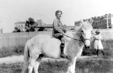
Photograph, Bill Willaton on one of Tacey's butcher's shop delivery horses, c 1920, 1920
The date is approximate. Bill Willaton was a driver for C E Gray & Son, bakers of Canterbury during the 1930s. Tacey's butcher shop (dem) was located at 629 Canterbury Road. Black and white photo of a young boy on a light-coloured horse in vacant land adjacent to Canterbury Road, Surrey Hills. In the background a girl is standing in front of a new-looking paling fence behind which can be seen local landmarks. On the right is Hansen's Terrace; on the far left part of the Surrey Hall can be seen and in the middle ground the rear of McNeill's Family Hotel (Surrey Lodge), Dartnell's corner and the side of the post office.tacey's butchers, horse-driven vehicles, hansen's terrace, surrey hills post office, surrey lodge, mcneill's family hotel, surrey hall, william willaton, bill willaton, surrey hills, canterbury road -
 Charlton Golden Grains Museum Inc
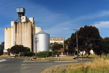
Photograph, Charlton Shire, Charlton Flour Mill, c.1987
A previous mill had operated in Charlton by Mr. W.E. Foreman on the banks of the Avoca River and was acquired in 1919 by Noske Bros. The present Flour Mill was built by Noske Bros and opened in May 1927. It was taken over by the Grain Elevator Board in the 1970s. Colour photograph of Charlton Flour Mill and silos. Intersection of Kaye & Davies Streets in the foreground. One large silver silo and three taller greyish concrete silos to the left. Three other cream coloured silos behind. There are pipes and sheds on top of the silos. There is a cream single story building to the right of the silver silo and a multi-storey building behind with eight window in the upper level. There is a small red brick building on the far left of the photo.w.e. foreman, noske bros, flour mill charlton, business, industry -
 Stawell Historical Society Inc
Photograph, Magdala cum Moonlight Mine with tailings dam & the Grampians in the background. c1900's
Magdala cum Moonlight Mine. Wide view of mine with Grampians Mountains in background.Mine with snow. The Cyanide plant was constructed in Sept 1900 and became the largest in Victoria. Just in front of the large tree a ramp can be seen and a horse and dray going up the ramp. Just below and to the left of the tree the cyanide vats can be seen. On the right is the poppet head of the Magdala and Oriental and North Cross Mine. The fire station is on the left in the far distance. with the W S Heal & Sons Coachbuilders Corner of Lazelle and Byrne Street businessMagdala Cum Moonlight Mine. Herbert's Studio. Stawellstawell gold mining -
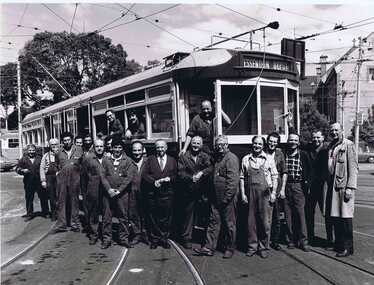 Melbourne Tram Museum
Photograph - Black & White Photograph/s, Melbourne & Metropolitan Tramways Board (MMTB), early 1980's
Black and white photograph of the Essendon depot maintenance staff standing with Fred Turner, Inspecting foreman in the middle of the photograph with one of the L classes located at the depot. Kevin Young, foreman at Essendon depot far right. Photo appeared in the Autumn 1982 issue of METRA news. See image 1005i2 for a cutting from the magazine which also features the manager and assistants at Essendon Depot, Laurie cummings, Andrew Stephanou and John Berns.in pencil on rear "8457/??"trams, tramways, essendon depot, workshops, depots -
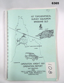 Bendigo Military Museum
Administrative record - Royal Australian Survey Corps Report on Operation Aright 91 conducted by 1 Field Survey Squadron 1991, 1 Fd Svy Sqn, 7 Oct 1991
Royal Australian Survey Corps Operation Aright 91 (Field Completion) was a Field Verification and Vital Assets Protection (VAP) Mapping Operation conducted in Far North Queensland during the period 18 Jun - 29 Jul 1991 by 1 Fd Svy Sqn. The Operation covered the 1:250,000 Map area of SD54-16 Hann River and SE54-7 Normanton.Pale Blue cover with motifs of North Queensland, crocodile, RASvy Corps Badge, Army Helicopter and Land rover. Contains an A4 paper report of typed pages and diagrams secured by a plastic binder.Cover Hand annotated "ASS 108" (Air Survey Sqn, copy 108)royal australian survey corps, rasvy, fortuna, army survey regiment, army svy regt, asr -
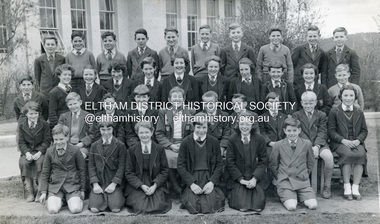 Eltham District Historical Society Inc
Photograph, Eltham High School, 1955; Teacher, Mrs Betty Erickson (nee Carrucan), 1955
Lew Howard's first year, age 11 Back Row: Murnane (far left), Brian Heard (3rd from left), Grant (5th from left), Lew Howard (2nd from right) Second Row: Pat Masefield (4th from left), Mrs Betty Erikson (nee Carrucan), Walter McLaren, Peter Brock (7th from left)Digital file only - scanned by EDHS from item on loangrant, murnane, brian heard, eltham high school, lew howard, lew howard collection, pat masefield, peter brock, walter mclaren, elizabeth (betty) erickson (nee carrucan) -
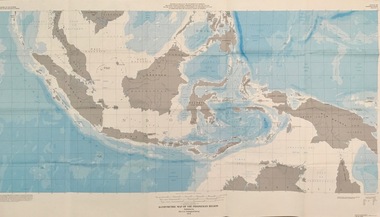 Federation University Historical Collection
Map - Geological, U.S. Government Printing Office, Bathymetric Map of the Indonesian Region: Folio of the Indonesian Region Map I-875-A, 1974, 1974
Map was prepared on behalf of the Government of Indonesia, The United Nations Economic Commission for Asia and the Far East, the Agency for International Development and the U.S. Department of State in cooperation with the Geological Survey of Indonesia. The area covered shows the islands and seas from Latitude 12 degree North to 16 degrees South and Longitude 90 degrees to 148 degrees. Various water features are also named.Large map showing the Indonesian area - islands and seasLongitude and Latitude are shown. Major / Capitol cities indicated. Names of those responsible for the productionindonesia, united nations economic commission, department of state, geological survey, latitude, longitude, government of indonesia -
 Wycheproof & District Historical Society Inc.
Bunguluke Map, Bunguluke District In 1923, 27.2.1923
By 1881 Bunguluke was a small settlement as recorded, December 5, in the Charlton "Mercury". It reports that in that year Draper's Store, Hotel and Post Office and residence at Bunguluke North was totally destroyed by fire. For years now there has been little sign of community life with houses few and far between and acreages have gone into larger holdings. The map references land blocks and owners for that era.This important map shows the local land ownership and local features that existed in 1923. This is a photocopied black and white map of Bunguluke in the County of Kara Kara, Number L5149. Marked - Photo Lithographed by W.J. Butson 27.2.1923. The details include numbers of allotments, property owners, roads, rivers. The boundaries marked are the Parish of Jeruk, Parish of Wycheproof, Parish of Cooroopajerrup. Wycheproof township location is shown with the Scale of Chains. Bunguluke maps for other years are also in the collection.map, bunguluke, jeruk, wycheproof, cooroopajerrup -
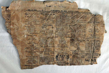 Orbost & District Historical Society
newspaper, December 13 1884
This piece of newspaper had been used as wallpaper lining. The Weekly Times was first published on September 11, 1869, by a group of Melbourne businessmen who owned the now-defunct Daily Telegraph, with the stated aim to be a “journal of literature, sport, agriculture, science and politics”. It is Australia’s oldest rural newspaper, and is known far and wide as the Bible of the Bush. (ref Weekly Times web-site)This is a useful research tool.A section of newspaper from the Weekly Times of 1884. there is also a photocopy of the item.newspaper weekly-times -
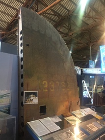 B-24 Liberator Memorial Restoration Australia Inc
Tail Plane from 'Little Eva' crash, Circa 1941/2
Commemoration of the crash of USAAF B-24 Liberator #41-23762 'Little Eva' of the 321st Squadron, 90th Bombardment Group based at Iron Range. Crashed near Burriejell waterhole at Moonlight Creek, Escott Station in far north Queensland on 2 December 1942. Two of the ten crewmen were rescued by the manager of Escott Station after 13 days of deprivation.2bxThe tail plane/fin from the crash site of Liberator 'Little Eva'. This site is registered as Doomadgee Queensland Australia, approximate GPS Co-ordinates: Latitude -17 56 24 Longitude +138 49 47.Faded USAAF Insignia 41-23762little eva, 4123762, usaaf -
 Robin Boyd Foundation
Document - Script, Robin Boyd, The Flying Dogtor. Episode 29 Mystery Mansion, 1963
The Flying Dogtor noticed that someone seemed to be living in Mangrove Mansion, an old homestead not far from Granny Goanna's house. The homestead had not been lived in for a hundred years, except when the famous bushranger Danny O'Canny used it for a hideout. The bush children went to investigate and find out who had moved in, so that they could tell their friend, The Flying Dogtor.The Flying Dogtor" series was broadcast on Australian Television Network (later becoming the Seven Network) between February and April 1964 (see item D254 for schedule).Typewritten, carbon copy, foolscap, 2 pagesthe flying dogtor, robin boyd, crawford productions, manuscript -
 Robin Boyd Foundation
Document - Script, Robin Boyd, The Flying Dogtor. Episode 32 Spooks, 1963
The bush children were exploring around an old deserted house called Mangrove Mansion when they received a number of nasty shocks: strange signs; spiderwebs; and spooks. Then they were chased by a great white creepy-looking floating monster spook and driven into a corner from which there seemed to be no escape. How they wished they were not so far from their friend, The Flying Dogtor.The Flying Dogtor" series was broadcast on Australian Television Network (later becoming the Seven Network) between February and April 1964 (see item D254 for schedule).Typewritten, carbon copy, foolscap, 3 pages. Middle page has one cm cut from the bottom.Handwritten pencil additions re telestrip.the flying dogtor, robin boyd, crawford productions, manuscript -
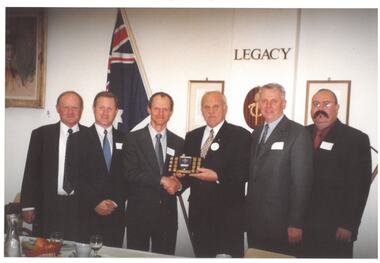 Melbourne Legacy
Photograph, Comradeship event, 2003
A legatee function in Legacy House with President David Ford. It is assumed to be 2003 as David Ford appears to be President. David Cull is on the far left, other names unknown. For many years Legatees would meet every Tuesday for a lunch and spend time together. Often there were guest speakers that would speak on a wide variety of subjects. There was a committee to organise and invite the speakers.A record of function for Legatees. Colour photo x 3 of a Legacy function.legatee event, comradeship, speakers -
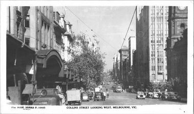 Melbourne Tram Museum
Postcard, Rose Stereograph Co, "Collins Street looking west, Melbourne", early 1940s
Rose Series postcard No. P 10445, titled "Collins Street looking west, Melbourne" looking west from mid-block between Swanston and Russell Streets. Has six W2 class trams in view, all carrying the wartime strip under the driver's windows and white bumper bars. In the far background can be seen chimney stacks of the gas works.Yields information about Collins Street in the early 1940s.Postcard - printed real photograph with Rose Stereograph Co. name on the rear.trams, collins st, w2 class, gas works, tramways, world war ii