Showing 1669 items
matching subdivisions
-
 Otway Districts Historical Society
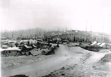
Photograph, Knox Collection, Beech Forest township, c.1903, c.1903
J.W. Gardner erected premises in Beech Forest which formed the core of a village. No further progress was made until access was facilitated though the development of a narrow gauge railway approved by the Victorian Parliament in 1898. Construction commenced in 1900. From this time Colac and Geelong business interests began investment in Beech Forest and established various retail and service establishments over the next few years. In 1902 three early settlers, Gardner, Charles Buchanan and John Cockerill, divided part of their land or bought land which was sold to businesses. On these subdivisions were created saleyards, general stores, a post office, bakery, blacksmithing, banks, a police station and lock-up, a public hall, churches, a state school, bootmaker, butcher, solicitor's office, hairdresser, billiard's saloon and newsagency.B/W. 188mm x 266mm. A general view of Beech Forest township in c.1903.beech forest; township; -
 Kew Historical Society Inc
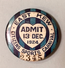
Badge - Fundraising Button, East Kew Citizens Sports Carnival: Admit 13 Dec. 1924, 1924
Most of the ephemera assembled by Francis Rigg were patriotic buttons but also included come sporting event buttons including two associated with the East Kew Citizens Sports Carnival. The subdivision of the area now known as Kew East commenced before World War 1, but it was not until the 1920s that it became fully developed. At this time, there was a strong Progress Association and this body raised funds to purchase land and build the East Kew Citizen’s Hall in Normandy Road, the first stage of which was completed in 1922. This hall was designed to be extended, although this never occurred, and the building now forms part of the facilities of the East Kew Uniting Church. The ‘East Kew Citizens Sports Carnival’ may well have been a fundraiser event for the building fund. As far as is known, the carnival was only held for a couple of years.Frances Rigg was a local business identity in Kew, at one stage managing the local branch of the English, Scottish and Australian (ES&A) Bank at 175 High Street from c. 1920 until the 1940s. After Francis Rigg’s death, the collection of buttons and medallions was inherited by his son, Ken Rigg (1922-2014). The collection was subsequently donated to the Kew Historical Society in 2015 by Francis' grandson, Adrian Rigg, at the time of the Gallipoli & Beyond Commemoration in 2015. The collection covers a period of almost 40 years. The majority of the buttons are patriotic buttons, issued and sold during and immediately after the First World World War (1914-1918) to raise funds for national and overseas causes. The collection also includes a number of locally significant sporting event buttons and sporting club medallions, issued in the 1920s and 1930s.A circular badge produced for the East Kew Citizens Sports Carnival in 1924. The badge has a ground of vertical stripes in shades of blue. The name of the event is within a white circular band. A white shield in the centre includes the words “Admit” which would indicate that the badge was purchased and worn on the day of the carnival to indicate that the wearer had paid the admission fee."East Kew Citizens Sports Carnival / Admit 13 Dec. 1924"kew east, sport buttons -
 Kew Historical Society Inc
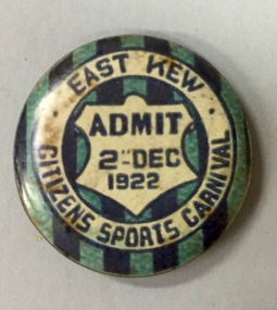
Badge - Fundraising Button, East Kew Citizens Sports Carnival, Admit 2nd December 1922, 1922
Most of the ephemera assembled by Francis Rigg were patriotic buttons but also included come sporting event buttons including two associated with the East Kew Citizens Sports Carnival. The subdivision of the area now known as Kew East commenced before World War 1, but it was not until the 1920s that it became fully developed. At this time, there was a strong Progress Association and this body raised funds to purchase land and build the East Kew Citizen’s Hall in Normandy Road, the first stage of which was completed in 1922. This hall was designed to be extended, although this never occurred, and the building now forms part of the facilities of the East Kew Uniting Church. The ‘East Kew Citizens Sports Carnival’ may well have been a fundraiser event for the building fund. As far as is known, the carnival was only held for a couple of years.Frances Rigg was a local business identity in Kew, at one stage managing the local branch of the English, Scottish and Australian (ES&A) Bank at 175 High Street from c. 1920 until the 1940s. After Francis Rigg’s death, the collection of buttons and medallions was inherited by his son, Ken Rigg (1922-2014). The collection was subsequently donated to the Kew Historical Society in 2015 by Francis' grandson, Adrian Rigg, at the time of the Gallipoli & Beyond Commemoration in 2015. The collection covers a period of almost 40 years. The majority of the buttons are patriotic buttons, issued and sold during and immediately after the First World World War (1914-1918) to raise funds for national and overseas causes. The collection also includes a number of locally significant sporting event buttons and sporting club medallions, issued in the 1920s and 1930s.A circular button produced for the East Kew Citizens Sports Carnival in 1922. The button has a ground of vertical stripes in shades of blue. The name of the event is within a white circular band. A white shield in the centre that includes the words “Admit” would indicate that the badge was purchased and worn on the day of the carnival to indicate that the wearer had paid the admission fee. "East Kew Citizens Sports Carnival, Admit 2nd December 1922"east kew, east kew citizens sports carnival, sports, badge, numismatics, francis rigg -
 Kew Historical Society Inc
Plan - Subdivision Plan, J Hurrey, Section 115 in the Parish of Boroondara Near Richmond Bridge, 1853
Despite the plans claims that it is a subdivision near the Richmond Bridge, Section 115 was located at what is now Camberwell Junction. While the plan only lists government roads rather than named streets, the section was located on the east side of Burke Road, stretching up the hill from the current Junction. Research on Trove, conducted by Kerry Fairbank, discovered an advertisement for unsold lots in Section 115 which clarifies the extent and location of subsequent land sales in the original section. The original article can be viewed through the link in the catalogue record. The interesting link to Kew is the reference to James Beavan as the purchaser of lots 14 and 15. The historian Gwen McWilliam has notes that a Mr Beavan changed his name from Bevan. The Bevans were descendants of the Derricks family of Kew. This subdivision plan is the earliest original map or plan in the collection which shows parts of what is now the City of Boroondara, dating from circa 1853. It provides important information for researchers on subsequent subdivisions following the original land sales in [Camberwell] Boroondara. The site, on the east side of Burke Road is a highly-significant and historic site. This is believed to be the only extant copy of the subdivision in public collections.A small plan on parchment listing 28 lots, between one and two acres each, for sale in Section 115 in the Parish of Boroondara, dating from 1853 when the portion was subdivided.Obverse: Lot 16 "Joseph Duval", Lots 14 & 15 "James Beavan". Other annotations (measurements) are unreadable. Reverse: "KH-981 / Section 115 in the Parish of Boroondara / Near Richmond Bridge / 1640T. / J Duval / 14-15 J. Beavanparish of boroondara, subdivision plans - camberwell, section 115 - boroondara, subdivision plans -- camberwell (vic), riverscape road, burke road, camberwell junction -
 Wodonga & District Historical Society Inc
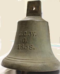
Functional object - Gordon Family Orchard Bell
The Gordons were architects and were associated with many buildings still standing in Albury and Wodonga, St Patrick's Church and the de Kerilleau Homestead among them. They established Vermont Orchard on 74 acres to the south of the Wodonga settlement. Here they grew fruit and nuts for the domestic and export market. The enterprising family also set about transforming some of the land by clearing it, creating streets and making general improvements. It was the biggest subdivision in Wodonga at the time. The 234 allotments in the Wodonga Estate were put up for sale by auction in May 1890. A total of 200 people were said to have attended. Gordon, William, Charles and Vermont streets in Wodonga are named after the family. This bell was used at the Vermont orchard to signal the beginning and end of the working day, as well as lunch breaks.The Gordon Family orchard bell is made of cast iron. It includes the inscription "J. C. W../G./1858." This is thought to represent the initials of John Gordon and sons Walter Joseph and Charles Goodwin Sylvester Gordon. There is some conjecture about this due to the date "1858". John was born in London, England in 1823 and died in 1880. Walter is generally accepted to have been born in 1857 and died 1903. In one family tree Charles is recorded as being born on 28 January 1858 but his birth was registered in 1860. The mystery of the date is therefore not fully resolved.On one side of the bell "J. C. W../G./1858."gordon family wodonga, gordon and gordon architects, vermont wodonga -
 Eltham District Historical Society Inc
Book, Jenny Brown et al, Out of the Mist; Osborne Peninsula, 2024
The Osborne Peninsula on the Yarra River at Warrandyte accommodates a limited number of properties and residents (70 households). The area is rich in geology and ecology, and an unusually rich endowment of human, built and creative history. Contents: Welcome: The landform: The River: Aboriginal occupation: The Miners: North Warrandyte :The Subdivision: The Lowes: The Osbornes: The Last Osborne: The Elders: The Relics: Dray Track: Water Wheel"Kauri Plaque: River track: Pines: Windmill Creek Bridge: The Koornong School: The Houses" Man Cave: MidCentury Classic: Enduring Original" Masterwork: The Muddies: The State Park: The Saving of Koornong Reserve: The Landcare Story: Flora and Fauna: The Vulnerable, Endangered and threatened: Birds: Mammals: "Waring" the wombat: Reptiles: Fish: Invertebrates: Flora: Fire. Published by the North Warrandyte (Osborne Peninsula) Landcare Group. Includes photos from EDHS collection.64 p. : ill., map ; 29.7 x 21 cm. (2 copies)yarra river, birrarung, dray track, fauna, geology, houses, indigenous history, koornong reserve, koornong school, lowe family, mining, mudbrick houses, north warrandyte, osborne family, warrandyte state park, water wheel, north warrandyte (osborne peninsula) landcare group, osborne peninsula -
 Kew Historical Society Inc
Plan - Subdivision Plan, Normanby Heights Estate, Kew, 1919
Prue Sanderson, in her groundbreaking ‘City of Kew Urban Conservation Study : Volume 2 - Development History’ (1988), summarised the periods of urban development and subdivisions of land in Kew. The periods that she identified included 1845-1880, 1880-1893, 1893-1921, 1921-1933, 1933-1943, and Post-War Development. These periods were selected as they represented periods of rapid growth or decline in urban development. An obvious starting point for Sanderson’s groupings involved population growth and the associated economic cycles. These cycles also highlighted urban expansion onto land that was predominantly rural, although in other cases it represented the decline and breakup of large estates. A number of the plans in the Kew Historical Society’s collection can also be found in other collections, such as those of the State Library of Victoria and the Boroondara Library Service. A number are however unique to the collection.The Kew Historical Society collection includes almost 100 subdivision plans pertaining to suburbs of the City of Melbourne. Most of these are of Kew, Kew East or Studley Park, although a smaller number are plans of Camberwell, Deepdene, Balwyn and Hawthorn. It is believed that the majority of the plans were gifted to the Society by persons connected with the real estate firm - J. R. Mathers and McMillan, 136 Cotham Road, Kew. The Plans in the collection are rarely in pristine form, being working plans on which the agent would write notes and record lots sold and the prices of these. The subdivision plans are historically significant examples of the growth of urban Melbourne from the beginning of the 20th Century up until the 1980s. A number of the plans are double-sided and often include a photograph on the reverse. A number of the latter are by noted photographers such as J.E. Barnes.The Normanby Heights Estate not unusually used hyperbole to attract purchasers to the auction of 17 lots facing Argyle Street (sic), Pleasant Avenue and Normanby Road. Predictably factors appealed to included the proximity to schools etc, the availability of public utilities, friable soil, picturesque views and ‘advancing settlement’. If that were not enough, the sales pitch exhorted prospective purchasers to consider their backbone. ‘Thrift is unquestionably the Backbone of any Nation. No better form of Thrift can be encouraged in the young citizen than by investing his or her savings in a piece of land in a growing, healthy and beautiful locality. NORMANBY HEIGHTS ESTATE admirably fits the need.’ The experience of Australia at war undoubtedly contributed to the use of terms such as ‘Backbone of a Nation’ and the appeal to egalitarian principles in the choice of the term ‘young citizen’. The recognition that women had savings and might be the prospective purchaser also reflects a new sense of the rights and entitlements of women in the postwar period.subdivision plans - kew, normanby heights estate, pleasant avenue, normanby road, argyle street -
 Kew Historical Society Inc
Plan - Subdivision Plan, Palmyra Estate, 1918
Pru Sanderson, in her groundbreaking ‘City of Kew Urban Conservation Study : Volume 2 - Development History’ (1988), summarised the periods of urban development and subdivisions of land in Kew. The periods that she identified included 1845-1880, 1880-1893, 1893-1921, 1921-1933, 1933-1943, and Post-War Development. These periods were selected as they represented periods of rapid growth or decline in urban development. An obvious starting point for Sanderson’s groupings involved population growth and the associated economic cycles. These cycles also highlighted urban expansion onto land that was predominantly rural, although in other cases it represented the decline and breakup of large estates. A number of the plans in the Kew Historical Society’s collection can also be found in other collections, such as those of the State Library of Victoria and the Boroondara Library Service. A number are however unique to the collection.The Kew Historical Society collection includes almost 100 subdivision plans pertaining to suburbs of the City of Melbourne. Most of these are of Kew, Kew East or Studley Park, although a smaller number are plans of Camberwell, Deepdene, Balwyn and Hawthorn. It is believed that the majority of the plans were gifted to the Society by persons connected with the real estate firm - J. R. Mathers & McMillan, 136 Cotham Road, Kew. The Plans in the collection are rarely in pristine form, being working plans on which the agent would write notes and record lots sold and the prices of these. The subdivision plans are historically significant examples of the growth of urban Melbourne from the beginning of the 20th Century up until the 1980s. A number of the plans are double-sided and often include a photograph on the reverse. In 1918, Punch reported the sale of the Palmyra Estate. ‘Adjoining the Findon Estate at Kew is Palmyra, one of the most charming localities in this most desirable of all suburbs. Palmyra has frontages to Findon, Bakewell, Carson and Stevenson streets. Facing Carson street are eight blocks of 60 by 140; on Stevenson-street four of 60 by 232; and there are four of 60 by 233 on Bakewell-street.’ [Bakewell Street and Findon Street were later to be amalgamated into Findon Crescent.]subdivision plans - kew, studley park, palymyra estate, stevenson street -- kew (vic.), carson street -- kew (vic.), bakewell street (findon crescent) -- kew (vic.) -
 Kew Historical Society Inc
Map - Subdivision Plan, Grenville Estate, 1922
Pru Sanderson, in her groundbreaking ‘City of Kew Urban Conservation Study : Volume 2 - Development History’ (1988), summarised the periods of urban development and subdivisions of land in Kew. The periods that she identified included 1845-1880, 1880-1893, 1893-1921, 1921-1933, 1933-1943, and Post-War Development. These periods were selected as they represented periods of rapid growth or decline in urban development. An obvious starting point for Sanderson’s groupings involved population growth and the associated economic cycles. These cycles also highlighted urban expansion onto land that was predominantly rural, although in other cases it represented the decline and breakup of large estates. A number of the plans in the Kew Historical Society’s collection can also be found in other collections, such as those of the State Library of Victoria and the Boroondara Library Service. A number are however unique to the collection.Subdivision plans are historically important documents used as evidence of the growth of suburbs in Australia. They frequently provide information about when the land was sold on which a built structure was subsequently constructed as well as evidence relating to surveyors and real estate and financial agents. The numerous subdivision plans in the Kew Historical Society's collection represent working documents, ranging from the initial sketches made in planning a subdivision to printed plans on which auctioneers or agents listed the prices for which individual lots were sold. In a number of cases, the reverse of a subdivision plan in the collection includes a photograph of a house that was also for sale by the agent. These photographs provide significant heritage information relating house design and decoration, fencing and household gardens.In advertising the twenty-two sites of the Grenville Estate in Cotham Road and Alfred Street, Kew, the auctioneers emphasised the proximity of the development to shops, schools, and churches. That mansions surrounded the Estate was publicised as an added attraction. The plan shows how at this stage A regrettable aspect of this plan is that it is pasted over, and obscures a real estate photograph by the Kew photographer Josiah Earl Barnes.subdivision plans - kew, grenville estate, glenferrie road, alfred street, thomas street, cotham road -
 Kew Historical Society Inc
Plan - Subdivision Plan, Rimington Nursery Estate, 1949
Pru Sanderson, in her groundbreaking ‘City of Kew Urban Conservation Study : Volume 2 - Development History’ (1988), summarised the periods of urban development and subdivisions of land in Kew. The periods that she identified included 1845-1880, 1880-1893, 1893-1921, 1921-1933, 1933-1943, and Post-War Development. These periods were selected as they represented periods of rapid growth or decline in urban development. An obvious starting point for Sanderson’s groupings involved population growth and the associated economic cycles. These cycles also highlighted urban expansion onto land that was predominantly rural, although in other cases it represented the decline and breakup of large estates. A number of the plans in the Kew Historical Society’s collection can also be found in other collections, such as those of the State Library of Victoria and the Boroondara Library Service. A number are however unique to the collection.The Kew Historical Society collection includes almost 100 subdivision plans pertaining to suburbs of the City of Melbourne. Most of these are of Kew, Kew East or Studley Park, although a smaller number are plans of Camberwell, Deepdene, Balwyn and Hawthorn. It is believed that the majority of the plans were gifted to the Society by persons connected with the real estate firm - J. R. Mathers and McMillan, 136 Cotham Road, Kew. The Plans in the collection are rarely in pristine form, being working plans on which the agent would write notes and record lots sold and the prices of these. The subdivision plans are historically significant examples of the growth of urban Melbourne from the beginning of the 20th Century up until the 1980s. A number of the plans are double-sided and often include a photograph on the reverse. A number of the latter are by noted photographers such as J.E. Barnes.The house lots in the Rimington Nursery Estate were advertised for sale on Saturday 22nd October 1949. The nine lots in the sale were in Stoke Avenue and Burke Road. Mathers & McMillan of 136 Cotham Road, Kew, offered the lots for sale. [The final sale of lots within the Rimington Nursery Estate occurred as late as 1958.]subdivision plans - kew, rimington nursery estate, monist victor road - kew (vic.) -
 Ringwood and District Historical Society
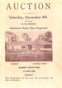
Memorabilia - History Timeline, Byways Homestead, Coolooli Estate, Ringwood East, 1878-2008
Development of Coolooli Estate with property titles and leaflets for the sale of "Byways" homestead, 4 Byways Drive, Ringwood East. Also the house at 9 Walhalla Drive, Ringwood East. Correspondence between David Best and Richard Carter re the estate. Coolooli subdivision includes lots fronting Isabel Avenue, Byways Drive, Coolooli Court, Walhalla Drive and Cleland Street. Property Titleholders include: George Blood William Chelman Thurgood Frederick Deine Laurie Arthur Wigley Charles Patterson Mary Aphra Patterson John Douse Langley August DiGilio Kenneth Ross Landy Mervyn MacPherson Brewer Richard Blennenhassett Best Jessie May Cleland John Brian Little Robert William Campbell Lynette Marie Campbell Lorraine Ruby Campbell David Charles Nicholls Barbara Janette Nicholls Ian Finlay Packer Nellie Packer -
 Ringwood and District Historical Society
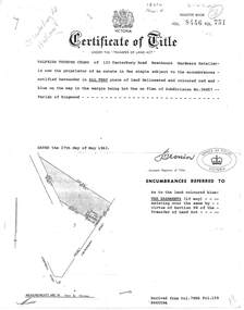
Document, Transfer of Land Act - 123 Canterbury Road, Heathmont, Victoria
Photocopied Certificate of Title Vol 8446 Fol 751 dated 27th May, 1963. Valfrids Teodors Celms of 123 Canterbury Road Heathmont, Hardware Retailer, is now the proprietor, Lot One on Plan of Subdivision No.36857, Parish of Ringwood. Page 2/3 - Transfers - Ansis Rudolf Kilevics and Mirdza Erika Kilevics, registered as joint proprietors 27th May, 1963. Mirdza Erika Kilevics registered as surviving proprietor 9th November, 1966. Velfrid Teodors Celms registered as proprietor 18th November, 1966. John Boer and Brenda Marion Boer registered as joint proprietors 11th July, 1973. Page 4/5 - Photocopy of Certificate of Title Vol 9557 Fol 423 dated 31 May, 1984 shows John Boer and Brenda Marion Boer mortgate discharged 31 October, 1984. -
 Southern Sherbrooke Historical Society Inc.
Information folder - "The Bungalow"
Material donated by current owner, Inga Melgaard, 20th November 2006.Folder containing information pertaining to "The Bungalow", Belgrave Heights. Material supplied by current owner, Inga Melgaard, on 20th November, 2006. Contents:/"Specifications of a bungalow for W.J. Murrell's (sic) Esq" drawn up by Leslie J.W.Reed, Architect, "Kaleno", 45 Thanet St, Malvern, dated September 1915./House sale advertisement, showing photograph, floor plan, description and location map./Subdivision maps, 6 sheets./Certificate of Title, Vol. 3892, Fol.778347, dated 28th May 1915, William Joseph Murrells./Certificate of Title, Vol. 6939. Fol. 1387757, dated 31st October, 1946, Agnes Murrells and Nora Murrells./CD containing Certificates of Title, photos taken in 1994 and photos taken by current owner, and a list of previous owners, 1915-1979./Copy of above list. -
 Bayside Gallery - Bayside City Council Art & Heritage Collection
Map, Department of Crown Lands and Survey et al, Moorabbin, County of Bourke, Government Roads, 1920
The cadastral map of the Parish of Moorabbin in Victoria (L.6104) shows parish boundaries and land ownership 1920 when Sandringham was a Town. The government roads have been coloured in red pencil.moorabbin, county of bourke, map, plan, land subdivision, land titles, foreshores, hampton, beaumaris, highett, cheltenham, department of lands and survey, land owners, cartographic material, brighton, sandringham, town of sandringham, government roads -
 Kew Historical Society Inc
Plan, Melbourne & Metropolitan Board of Works : Borough of Kew : Detail Plan No.1575, 1905
The Melbourne and Metropolitan Board of Works (MMBW) plans were produced from the 1890s to the 1950s. They were crucial to the design and development of Melbourne's sewerage and drainage system. The plans, at a scale of 40 feet to 1 inch (1:480), provide a detailed historical record of Melbourne streetscapes and environmental features. Each plan covers one or two street blocks (roughly six streets), showing details of buildings, including garden layouts and ownership boundaries, and features such as laneways, drains, bridges, parks, municipal boundaries and other prominent landmarks as they existed at the time each plan was produced. (Source: State Library of Victoria)This plan forms part of a large group of MMBW plans and maps that was donated to the Society by the Mr Poulter, City Engineer of the City of Kew in 1989. Within this collection, thirty-five hand-coloured plans, backed with linen, are of statewide significance as they include annotations that provide details of construction materials used in buildings in the first decade of the 20th century as well as additional information about land ownership and usage. The copies in the Public Record Office Victoria and the State Library of Victoria are monochrome versions which do not denote building materials so that the maps in this collection are invaluable and unique tools for researchers and heritage consultants. A number of the plans are not held in the collection of the State Library of Victoria so they have the additional attribute of rarity.Original survey plan, issued by the MMBW to a contractor with responsibility for constructing sewers in the area identified on the plan within the Borough of Kew. The plan was at some stage hand-coloured, possibly by the contractor, but more likely by officers working in the Engineering Department of the Borough and later Town, then City of Kew. The hand-coloured sections of buildings on the plan were used to denote masonry or brick constructions (pink), weatherboard constructions (yellow), and public buildings (grey). Plan No.1575 shows that in the area bounded by Wellington Street, Edgevale Road, Glenferrie Road, and Cotham Road, there had already been significant subdivision of land and houses constructed. As one of the highest points in Kew, as expected, there were already some significant mansions built on large allotments of land. Many of these mansions are identified by name on the plan such as ‘Kelso’, ‘Abbotsford’, ‘Clarendon’ and ‘Ashlyn’ in Cotham Road. Other houses of equal size are unnamed on the plan.melbourne and metropolitan board of works, detail plans, maps - borough of kew, mmbw 1575, cartography -
 Ringwood and District Historical Society
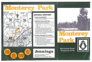
Flyer, Subdivisional Land Sale Brochure, Monterey Park, Warrandyte Road, Ringwood North, Vic. - circa 1980s
Two A4 size gloss paper pages advertising residential development including outline of local facilities and services, with locality map and layout of Monterey Park streets.Monterey Park - Jennings Industries Limited, 690 Springvale Road, Mulgrave, 3170, Phone 5618000. Subdivision includes Parkwood High School, Tortice Drive, Heape Way, Appleberry Place, Stringybark Court, Conifer Court, Crawley Grove, Monterey Close (later Monterey Place), Lucy Place, Middlebrook Drive, Gahnia Close, Glanfield Court, Cone Close, Jull Parade, Pinus Close (later Pinetree Court), Radiata Close, Old Warrandyte Road, and entry from Warrandyte Road. -
Warrnambool and District Historical Society Inc.
Document, Wollaston sale, 1919
This is a poster advertising the sale of part of the Wollaston Estate in Warrnambool in 1919. The sections for sale were Allotments 1, 18 and 19 which included the Wollaston Homestead. The original Wollaston property of 679 acres was selected by Thomas Manifold in the late 1840s. This land, on the northern side of the Merri River, near the Woodford Road was three kilometres from the Warrnambool town. The first farmer we know who leased the property was William Simpson. Walter Manifold inherited the property and he took it over in 1884. The swing bridge he built in 1890 still stands today. In 1919 the Closer Settlement Board of Victoria acquired Wollaston and 17 lots were sold to returned soldiers for farming purposes. By 1930 there were only five soldier settlers remaining. In 2009 further subdivision took place with lots sold for residential purposes. The homestead allotments were sold separately in 1919 with various owners of the homestead itself recorded since that time. This poster is of interest as it shows the areas of the Wollaston Estate which were sold in 1919. The history of this estate is well-documented and of importance in the history of Warrnambool. This is a sheet of paper with red and black printing and a map of the Wollaston Estate which is photo-lithographed. The sheet has been folded three times. It has some small tears at the top of the page. wollaston, history of warrnambool, walter manifold -
 Eltham District Historical Society Inc
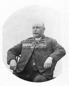
Photograph, Councillor Albert Henry Charles Price
Albert Price (1860- 1945) purchased a 31 acre block of the Montmorency subdivision. From 1911 to 1922 he was a member of the Heidelberg Shire Council and was later President of that shire. He then became the first Councillor representing Montmorency within the Shire of Eltham. He served from 1925 to 1945. He was President of the Shire five times. His achievements included bringing electric light and water into Eltham, Montmorency and Briar Hill, the improvement to the train service, together with the construction of a station at Montmorency. He was a member of the Montmorency State School committee and was also a mason. He died in May 1945 aged 85 years while still being a serving councillor. He is buried at Fawkner Cemetery. His name is remembered in the naming of Price Avenue, Montmorency. A memorial plaque was placed in the original Memorial Hall in Rattray Road in memory of Albert and Janet Price's commitment to the new suburb of Montmorency. This photo forms part of a collection of photographs gathered by the Shire of Eltham for their centenary project book, "Pioneers and Painters: 100 years of the Shire of Eltham" by Alan Marshall (1971). The collection of over 500 images is held in partnership between Eltham District Historical Society and Yarra Plenty Regional Library (Eltham Library) and is now formally known as 'The Shire of Eltham Pioneers Photograph Collection.' It is significant in being the first community sourced collection representing the places and people of the Shire's first one hundred years.Digital imagesepp, shire of eltham pioneers photograph collection, councillor price, montmorency, albert price, portrait -
Glen Eira Historical Society
Article - ELSTER AVENUE, 18, ELSTERNWICK
This file contains 5 items about this property: 1/Handwritten notes from titles searches of 18 Elster Avenue complied by Peta Darke dated 29/07/2014 – photocopy 7 pages. 2/Handwritten list of Sands & McDougall entries for 1915 to 1970, and notes to present, compiled by Peta Darke dated 29/07/2014. 3/Photocopy of two pages of the title to the property dated 22/10/1909. Includes plan of subdivision of the area. 4/Photocopies of five advertisements from The Argus relating to the property: 28/08/1918 Land Wanted 12/07/1921 Lost Heifer 26/04/1919 Owner has House For Sale (20 Elster Avenue) 10/05/1919 same – No. 20 For Sale 29/11/1927 M. M. Taylor has Oats and Barley For Sale. 5/Photocopy of photograph of exterior taken by R. Darke circa 1998.elsternwick, gardenvale, elster avenue, robinson charles, caulfield, robinson william henry, robinson george augustus, inglis robert, davies matthew henry, ross william murray, colonial investment and agency company, victorian permanent property investment and building society, calder william anderson, watson john, rosstown junction railway and property company, kooyong road, college street, parnell (muntz) street, lempriere john thomson, thomson william hamilton, collinson william morris, elizabeth street, cumming euphemia, taylor thomas, hill caroline, evans alexander cameron, evans horace, evans gordon lemaitre, roach joyce rubena, evans mary arthur, nallo luigi, nallo joyce, north road, darke richard alexander, darke peta, peile edgar stoddart, corio, darke caroline elizabeth, darke cameron andrew, oswald street, bertram street, taylor m. m., land subdivision, architectural styles, edwardian style, brick houses, teak street, caulfield south -
 Ringwood and District Historical Society
Document - Research Folder, Helm Family, Oban Road, Ringwood, Victoria - 1917-2008
Transcription of conversation with Alma and Kelly Helm by Richard Carter (Past President of Ringwood Historical Society) and Larraine Haslam on 18 July 2008 detailing family history. Certificates of title of land between Oban Road and Mullum Mullum Creek. Six and a half acres sold to the Helm Family in 1917. Includes Certificate of Title Vol 5311 Fol 1062052 Carolyn Mary Glynn dated 27 April 1927. Certificate of Title Vol 4023 Fol 804560 Robert Beckett dated 19th January 1917. Plans of Subdivision including Oban Road, Barnsdale Way, Loughies Track, 1997. Certificate of Title Vol 4029 Fol 805702 Ellen Elizabeth Helm dated 8th February 1917. Transfer of Land (2093031) payment to James William Dartnell by Alma Mary Helm and Elsie May Helm of Oban Road, Ringwood North - 13th August, 1947. -
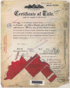
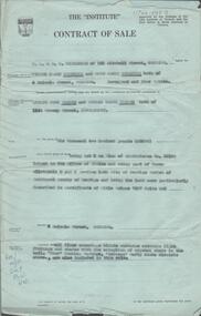 Bendigo Historical Society Inc.
Document - H. A. & S. R. WILKINSON COLLECTION: CONTRACT OF SALE
Contract of sale dated 27th March, 1958 between Mr. V. V. & Mrs R. M. Wodetzki (vendor) and Mr. L. J. & Mrs. T. M. Pascoe (purchaser). Solicitor for vendor: Watson, James & Rogers, Bull Street, Bendigo. Solicitor for purchaser: Watson, James & Rogers, Bull Street, Bendigo. Property 4 Malcom Street, Bendigo being lot 5 on plan of subdivision No. 22158(?) lodged in the office of titles and being part of Crown allotment8 and 9 section 165C land described in certificate of title volume 7597 folio 005(?), together with all floor coverings, blinds, curtains, electric light fittings and shades with the exception of crystal hade in the hall. "Shor" washing machine, "Masters" early electric stove. Price: 6,200 pounds. Attached Statement pursuant to section 34 of the estate agents act 1956 and 4 hand written notes.organization, business, h.a. & s.r wilkinson real estate -
 Bendigo Historical Society Inc.
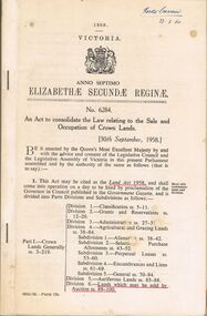
Book - 1958 VICTORIA ANNO TERTIO ELIZABETHÆ SECUNDÆ REGINÆ NO. 6284, 23/2/60
A small book owned by Accountant & Auditor Harold Curnow dated 23/2/60 detailing "An Act to consolidate the Law relating to the Sale and Occupation of Crown Lands." on page 61 it also has a 2/10/61 newspaper article and a June 27, 1962 page from the Victoria Gazette both of them detailing the Laws. The first page is written as following "Harold Curnow 1958. VICTORIA ANNO SEPTIMO ELIZABETHÆ SECUNDÆ REGINÆ No. 6284. An Act to consolidate the Law relating to the Sale and Occupation of Crown Lands, [30th September, 1958.] Be it enacted by the Queen's Most Execellent Majesty by and with the advice and consent of the legislative Assembly of Victoria in this present Parliament assmled and by the authority of the same as follows (that is to say) 1. This act may be cited as the Land Act 1958. and shall come into operation on a day to be fixed by proclamation of the Governor in council published in the Goverment Gazette, and is divided into Parts Divisions and Subdivisions as Follows:-"victoria -
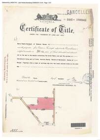 Ringwood and District Historical Society
Document, Certificate of Title - Harry Temple Marshall, Wesburn Farmer, Vic. - part of Crown Section 20, Parish of Warrandyte, County of Evelyn - 1928
A4 copies of Landata Victoria Historical Search documents - Vol 5485 Fol 1096803. Harry Temple Marshall is now the proprietor of an Estate in Fee-simple subject to the Encumbrances notified hereunder ... 10 acres 3 roods 10 perches or thereabouts, together with a right of carriage way over roads coloured brown. Subdivision map includes un-named roads - western side is Wonga Road (later Warranwood Road), and eastern side is Grandview Grove (later Bemboka Road), both north of Plymouth Road, Ringwood, Vic. Transfers include Harold Claude Howship, 1st December, 1928 James Bell McAlpin, 26th March, 1939. -
 Eltham District Historical Society Inc
Photograph, Fay Bridge, EDHS Heritage Walk: Shillinglaw Farm, Eltham, 2 September 2023
On Saturday September 2, 2023, Russell Yeoman led a group of 22 society members and interested others on a walk following trhe bounadries of the original Shillingalw farm. Commencing at the corner of Panther Place and Library Place, we proceeded up to Shillinglaw Cafe then the Shillinglaw trees at the former Eltham Shire Office site then along Main Road to the fire station then throughh St Laurence Lane and uinder the railway line , along Diamond Street then return via the Diamond Creek trail behind Andrew Park. The actual farm boundary went past the creek and further up the hill. The original farm comprised lot 90 of Holloway’s 1851 subdivision of Little Eltham. Its area was 30 acres lying east of the Diamond Creek and north of Henry Street. A number of stops were made to look at maps and early photos illustrating the gradual reduction of the farm area and the early history of the railway and other community uses, that occupied parts of the site.fay bridge collection, 2023-09-02, activities, eltham, eltham district historical society, heritage excursion, shillinglaw farm -
 Eltham District Historical Society Inc
Photograph, Liz Pidgeon, EDHS Heritage Walk: Shillinglaw Farm, Eltham, 2 September 2023
On Saturday September 2, 2023, Russell Yeoman led a group of 22 society members and interested others on a walk following trhe bounadries of the original Shillingalw farm. Commencing at the corner of Panther Place and Library Place, we proceeded up to Shillinglaw Cafe then the Shillinglaw trees at the former Eltham Shire Office site then along Main Road to the fire station then throughh St Laurence Lane and uinder the railway line , along Diamond Street then return via the Diamond Creek trail behind Andrew Park. The actual farm boundary went past the creek and further up the hill. The original farm comprised lot 90 of Holloway’s 1851 subdivision of Little Eltham. Its area was 30 acres lying east of the Diamond Creek and north of Henry Street. A number of stops were made to look at maps and early photos illustrating the gradual reduction of the farm area and the early history of the railway and other community uses, that occupied parts of the site.2023-09-02, activities, eltham, eltham district historical society, heritage excursion, shillinglaw farm, 895 main road, amplifon, andrew park, andrew pocket park, arthur street, bar de tapas, barber shop, barry plant estate agent, blockbuster, bus depot, car park, carparks, central park, cleaver & co hair, commonwealth bank, crust pizza, divine bridal, dr ash constance, dudley street, eltham book shop, eltham convenience store, eltham fire station, eltham library, eltham newsagency, eltham optical, eltham railway station, eltham shops, fay bridge, fire bell, flagpole, flight centre, grill'd, information sign, iso chook, jellis craig estate agent, judge book village, kebab nation, kx pilates, la zanyas, liquorland, little drop of poison, lorraine jones & associates solicitors, luck street, machan indian restaurant, main road, mecho en mexico, missing gorilla, morrison kleeman real estate, pavilion menswear, platform 3095, playtherapy melbourne, pryor street, ray white real estate, restaurants, sage bulk whole foods, shillinglaw trees, sign, snap fitness, southern cross medical imaging, specsavers, st laurence lane, st vincents care service, thompson's pharmacy, todaro, united service station, vyve body & skin, welcome to eltham town, westpac bank, yang's kitchen, youth road -
Glen Eira Historical Society
Plan - Centre Road, 734, Bentleigh East
A one page typed letter, dated 30/09/1970 addressed to S P Simmonds Estate Agency from William Lasica and Co Solicitors requesting a valuation of the property at 734 Centre Road, Bentleigh East. The file also includes four pages of handwritten, undated and unattributed working notes with property description, calculations and a rough plan (96mm x 94mm) of the ground floor of the building for the valuation. Also included in the file is a two page duplicate copy of a typed letter, dated 08/10/1970 from W V Scott to William and Lasica Co Solicitors containing the valuation of the relevant property and rental details. The file also includes a one page photocopy of a handwritten document dated 15/11/1967. It gives details of a previous mortgage. The file also includes a photocopy, dated 26/09/1970, of the Certificate of Title of Lot 6 of Subdivision No 60044 Parish of Moorabbin. It includes a plan of the property (139mm x 123mm).klauss anna sara, klauss edward, green william james, green margaret estelle, green william thomas, myers thomas lee, lombard joseph patrick, graham george kinnell, tobin thomas norman, mcintosh edward joseph, bentleigh east, east bentleigh, centre road, bentleigh station, omeo court, east boundary road, s p l constructions pty ltd, r k c nominees pty ltd, maryland street caulfield investors, flats, land values, land titles, rents, renting, \ -
Glen Eira Historical Society
Document - Cantala
Various documents and correspondence detailing the history of the house and land on the corner of Dandenong and Waiora Roads, Caulfield, known as Cantala before being demolished and the land subdivided. The first document is a typed 3 page history from Caulfield Historical Society dated 02/1974, describing the owner of the property, Septimus Miller, as well as architectural features of the house Cantala. The second document is one page of typed correspondence from T J Hart to the editor of Southern Cross, dated 01/11/1973, describing the architectural features and history of Cantala. The file also includes a copy of a typed letter from Brighton Historical Society concerning research conducted about Cantala and the subdivision and detailing the owners and occupiers of flats erected where Cantala stood. Accompanying this document is a one page handwritten note providing the same details. Finally, the file includes a one page photocopy, undated, of an entry in Who’s Who in the World of Women of Mrs Septimus Miller (Muriel), the second wife and widow of Septimus Miller.miller septimus, miller henry money, mattinson elizabeth, bell clara johnstone, stewart gwendoline, henderson helen muriel, miller ronald nevil damian, salway william, hart t j, miller helen, pirera m t, fetter a, bullock hilary, landells rosalind, redleap, cantala, caulfield, caulfiled north, dandenong road, wiora, waiora road, alma road, brighton cemetery, caulfield racecourse, findon avenue, cantala avenue, olgita, rivoli, caulfield historical society, victoria racing club, horse racing, italianate style, art deco, architectural styles, architectural features, balconies, towers, stairs, bay windows, mansions, stables, land subdivisions, monuments and memorials, gothic (revival) architecture, drawing rooms, walking trails, parks and reserves, gardens, flats -
 Eltham District Historical Society Inc
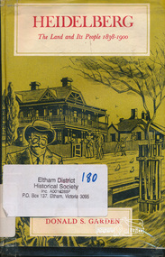
Book, Melbourne University Press, Heidelberg: The Land and its People 1838-1900 by Donald S. Garden, 1972
Although Heidelberg was one of the first parts of the Port Phillip District to be settled, and became important and prestigious in the early years of the colony, its history has been largely neglected. The beauty and fertility of the land and its proximity to Melbourne quickly resulted in the establishment in the 1830s and 40s of large estates by wealthy gentlemen. A romantic spot, Heidelberg became popular with picnickers and later attracted an artists' colony. The character of the area then gradually changed as a distinct village community emerged, and market gardens began to flourish. Unlike some of the suburbs closer to Melbourne, Heidelberg eventually wilted under economic pressures from which it did not fully recover until the turn of the century. This book allows us within the larger contect of the colony's fortunes and misfortunes, the struggle of Heidelberg the suburb to be born " - flyleaf. Contents: First land sales and subdivisions, gentlemen of Heidelberg and their estates and activities, infant rural community. golden fifties, decline and backwater, railway and land boom, a maturing community , the depression of the nineties. This book was the first to focus on the area of Heidelberg and its context within the Port Phillip District and remains significant as a key secondary source for describing the history of the area. It is relevant to the contextual history of its neighbour the former Shire of Eltham and Shire of Nillumbik.Hardback. Includes illustrations and index, 219 p.ISBN 0522840191port phillip district, ivanhoe, heidelberg, charles wingrove -
Glen Eira City Council History and Heritage Collection
Document (Item) - Newspaper (digital), Caulfield Contact, 1977
The Caulfield Contact was the official newspaper of the City of Caulfield from 1976-1994. The City of Caulfield was the Municipal Council for an area of the South Eastern suburbs of Melbourne, including Brighton East, Carnegie, Caulfield, Elsternwick, Gardenvale, Glen Huntly, McKinnon, Murrumbeena, Ormond and St Kilda East. Following Amalgamation of City of Caulfield and parts of the City of Moorabbin in 1994, the Caulfield Contact was followed by the Glen Eira News. Includes references to the following: Children's Neighbourhood Centre Caulfield; Fire destroyed Caulfield Park Bowling Club; Naming of Harleston Park; Home Handyman Service; Profiles Councillors Peter Baitz, Ron Walters; Carnegie-Glenhuntly Football Club formed Council drops approval of rail crossings over Neerim and Glenhuntly Roads; Profiles Councillor Alwyn Samuel, Glen Richards; First stage of Nepean Highway widening; Minister approved re-subdivision; Council spills; Exciting development of Caulfield Park; Profiles Councillor Max Blair, Councillor Brian Rudzki; Tram shelter classified by National Trustcity of caulfield, caulfield, glen eira, city of glen eira, caulfield contact, children's neighbourhood centre caulfield, fire destroyed caulfield park bowling club, naming of harleston park, home handyman service, profiles councillors peter baitz, ron walters, carnegie-glenhuntly football club formed, council drops approval of rail crossings over neerim and glenhuntly roads, profiles councillor alwyn samuel, glen richards, first stage of nepean highway widening, minister approved re-subdivision, council spills, exciting development of caulfield park, profiles councillor max blair, councillor brian rudzki, tram shelter classified by national trust -
 Eltham District Historical Society Inc
Postcard - Photograph postcard, Old Bridge, Kaylock's Crossing, Brougham Street, Eltham, c.1912
Date estimated to be circa 1912 based on the style of printing on the reverse of the card - Kodak Austral paper for real photo postcards, the paper was manufactured c.1908-1914 (See also POSTCARDS ON KODAK PAPER - IS IT POSSIBLE TO "DATE" THEM? http://tps.org.au/bb/viewtopic.php?t=115) Brougham Street was created in Josiah Holloway's 1851 subdivision of Little Eltham. It was one of several east-west streets shown on the subdivision plan as crossing the Diamond Creek. The western part was named Wellington Street on the subdivision plan but was later changed to conform with the name of the eastern part as acknowledgement of the continuity of the street. It is not known when the first bridge was constructed in Brougham Street however it was certainly mentioned at Council’s meeting of 2 June 1884 as being in a dangerous state of repair. This photo (c.1895) of an old bridge shows a very low-level simple log girder bridge crossing the creek at a right angle and so the approaches involved bends in the road alignment. This bridge was generally known as Kaylocks Bridge or Kaylock’s Crossing after the owner of the adjoining land. It was most likely built from around the mid-1850s, or a crossing of some fashion established as Richard George Kaylock, butcher of Little Eltham and his wife Emily Ann settled there in 1854. His property was in Wellington Street (now Brougham Street) and apparently extended across the Diamond Creek. The land on the western side of the creek was farmed, the house being on the eastern side. Kaylock's Bridge formed part of the original coach road to Eltham and in 1922 was described as an "old rustic bridge". Its low level and insubstantial construction made it susceptible to flood damage, necessitating frequent closures until repairs could be carried out. In September 1922, Council called for tenders for a new timber bridge to be constructed at Kaylock’s crossing. An engineering assessment carried out for the Council by Macleod Consulting at the time of the replacement suggested that the construction details indicate that it was in the 1900s, however this dating could possibly have been the result of numerous repairs undertaken over the years to flood damage. The tender was awarded to Mr Weller of Kangaroo Ground who commenced work in February 1923 on a higher-level timber trestle bridge. Work was slowed due to illness of the contractor and the accidental death of a man in March 1923 following the collapse of the bank after he had jumped into a hole that had just been blasted. The bridge was completed around July 1923 at which point the old structure was pulled up, marking what was described in the ‘Advertiser’ newspaper as the passing of an old and well-loved landmark in the district. In April 1924 the approach to Kaylocks bridge was washed away during the heavy flooding that destroyed the Main Road bridge. The western side was repaired, and an extra span was added to the eastern side using timber from the destroyed Main Road bridge. The bridge was again severely damaged four months later in August 1924 When a lack of finances delayed repairs to the Bridge Street bridge in 1931 (also referred to as Obelisk Bridge at the time), traffic had to detour via Brougham Street for some time. Local residents feared that the Bridge Street bridge might never reopen. Kaylocks Bridge was constantly subject to damage by floods. In the 1934 flood it was submerged by two feet of water. In more recent times the bridge was again severely damaged by flooding and repairs made. A new bridge and adjoining footbridge were constructed in 2009.Digital file only Postcards scanned from the collection of Michael Aitken on loan to EDHS, 2 Sep. 2022michael aitken collection, eltham, postcards, bridge, brougham street, diamond creek (creek), kaylocks bridge, wellington street