Showing 1750 items
matching brick houses
-
 Eltham District Historical Society Inc
Photograph, Peter Pidgeon, Heritage Excursion; Laughing Waters, Laughing Waters Road, Eltham, 7 Sep 2013, 7 Sep 2013
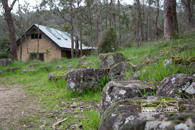
LAUGHING WATERS WALK This excursion was a follow up to the Laughing Waters Story told to us by Jane Woollard at our Annual General Meeting in March 2013. It involved a walk commencing from the corner of Laughing Waters and Overbank Roads along Laughing Waters Road to its eastern end and returning partly over the same route - a total distance of about 2.5km. On the way we visited the two artist in residence properties to view the houses on them that are associated with Alistair Knox, Gordon Ford and others in the local mud brick and artistic community. An unexpected afternoon tea was offered to us by the artists in residence and we had a brief opportunity to view inside one of the houses.Born Digitalactivities, eltham district historical society, heritage excursion, laughing waters road, eltham -
 Eltham District Historical Society Inc
Photograph, Peter Pidgeon, Heritage Excursion; Laughing Waters, Laughing Waters Road, Eltham, 7 Sep 2013, 7 Sep 2013
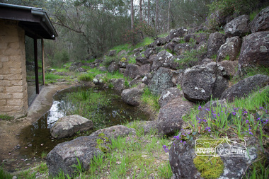
LAUGHING WATERS WALK This excursion was a follow up to the Laughing Waters Story told to us by Jane Woollard at our Annual General Meeting in March 2013. It involved a walk commencing from the corner of Laughing Waters and Overbank Roads along Laughing Waters Road to its eastern end and returning partly over the same route - a total distance of about 2.5km. On the way we visited the two artist in residence properties to view the houses on them that are associated with Alistair Knox, Gordon Ford and others in the local mud brick and artistic community. An unexpected afternoon tea was offered to us by the artists in residence and we had a brief opportunity to view inside one of the houses.Born Digitalactivities, eltham district historical society, heritage excursion, laughing waters road, eltham -
 Eltham District Historical Society Inc
Photograph, Peter Pidgeon, Heritage Excursion; Laughing Waters, Laughing Waters Road, Eltham, 7 Sep 2013, 7 Sep 2013
LAUGHING WATERS WALK This excursion was a follow up to the Laughing Waters Story told to us by Jane Woollard at our Annual General Meeting in March 2013. It involved a walk commencing from the corner of Laughing Waters and Overbank Roads along Laughing Waters Road to its eastern end and returning partly over the same route - a total distance of about 2.5km. On the way we visited the two artist in residence properties to view the houses on them that are associated with Alistair Knox, Gordon Ford and others in the local mud brick and artistic community. An unexpected afternoon tea was offered to us by the artists in residence and we had a brief opportunity to view inside one of the houses.Born Digitalactivities, eltham district historical society, heritage excursion, laughing waters road, eltham -
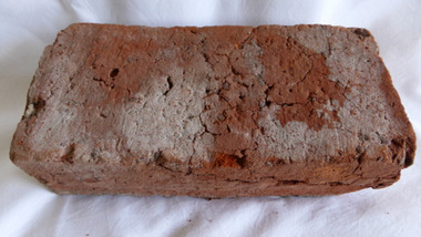
 Kiewa Valley Historical Society
Brick - Hand-made Tawonga Brick Factory
... of a hand made brick used for building eg. houses Brick - Hand-made ...Hand-made at the Tawonga Brick factoryMade at the Tawonga brick factory.Formerly KV 106 Rough surface of a hand made brick used for building eg. houseshand-made brick, tawonga brick factory -
 Eltham District Historical Society Inc
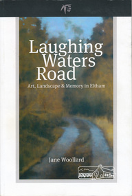
Book, Shire of Nillumbik, Laughing Waters Road: art, landscape & memory by Jane Woollard, 2016
"Laughing Waters has been a source of inspiration for many artists and designers, and was a natural extension of the dynamic art and lifestyle movement that began in the 1930s at Montsalvat. It was also an important site in the development of the Melbourne art scene in the 1960s and '70s, especially the earth building movement known as the Eltham Style. Since 2001 more than eighty artists have been in residence at Laughing Waters in Birrarung House and Riverbend. Their experiences and art making are woven together with Wurundjeri, European and family histories to create an evocative account of a special place in a bushy outer suburb of Melbourne." -- back cover. Eltham District Historical Society is acknowledged in the Acknowledgments section of this book.264 pages : illustrations, maps, portraits ISBN 9780994486707laughing waters, eltham, yarra river, artists, killeavey, mud bricks -
 Eltham District Historical Society Inc
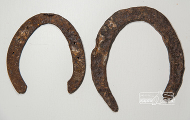
Horseshoe, Two horseshoes, c.1860, 1860s
ELTHAM POLICE QUARTERS & REAR STABLE (FORMER), is listed on the Victorian Heritage Database. The stables are described: "The original single stall brick stables building with loft, built in 1859-60.."These horseshoes were dug up by the owners of the property adjoining the former Eltham Police Station and Court House site behind the stables when working in their garden. Presumably they were discarded adjacent to the stables where the Police horses were kept and over time became covered with soil and other material. They were presented to the Society by the owner during the Local History Centre Open Day held for the Society's 50th anniversary 4 March 2017.Two iron (rusty) horsehoes, one significantly larger than the other; the larger shoe appearing to be not fully manufactured as no nail holeshorseshoe, police residence, police station, brougham street, eltham -
 Eltham District Historical Society Inc
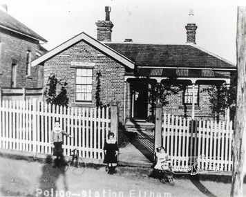
Photograph, Police House, Main Road Eltham, 1890s
Police Sergeant's family house, Police Station to right and Courthouse to left of house..Copy of black and white photograph of brick Police residence, 728 Main Road, Eltham, cnr. Brougham Street. Photograph includes 3 young children in front of fence. Circa 1890s police residence, police station, courthouse, eltham, main road, houses -
 Eltham District Historical Society Inc
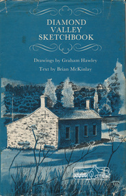
Book, Diamond Valley sketchbook / text by Brian McKinlay ; drawings by Graham Hawley, 1973
Contents include short articles and illustrations of historic properties within the municipalities of Banyule, Nillumbik and Whittlesea. Including The Griffin House, Rosehill, Lower Plenty, The Austin Hospital, Heidelberg, St John's Church, Heidelberg, Banyule, Heidelberg, Trestle Bridge, Eltham, Diamond Valley railway, The Shillinglaw Cottage, Eltham, Montsalvat, Old England Hotel, Heidelberg, Eltham Primary School, Mud brick homes, Eltham, Sweeney's Cottage, Eltham, Pound Pend Tunnel, The Gold Memorial, Potter's Cottage, Memorial Tower, Charterisville, Weller's Pub, The Barrel, Eltham, Hassall's Gallery, The Old Bridge, Greensborough, Diamond Valley Shire Offices, Greensborough, St Katherine's Chapel, Yan Yean Reservoir, Mernda Hotel, Mernda Mechanics Institute, Old Barn, Mernda, Parade College, La Trobe University.Hardback with jacket ; 63 p. : ill., maps ; 22cm. diamond valley shire, shire of nillumbik, city of whittlesea, city of banyule, shillinglaw cottage, weller's hotel -
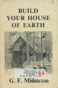 Eltham District Historical Society Inc
Book, George Frederick Middleton, Build your house of earth : a manual of earth wall construction / G.F. Middleton, 1979
"This book was "the bible" of mud brick and Pise builders in the 1950s"Paperback; xiii, 130 p., [8] p. of plates : ill. (some col.), diagrs., plans ; 25 cm.ISBN 0908136722 (pbk.)buildings, mudbrick, mud brick construction -
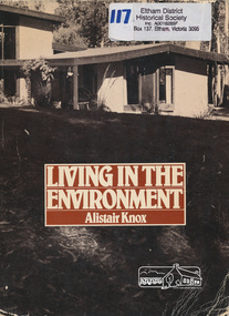 Eltham District Historical Society Inc
Book, Alistair Knox 1912-1986, Living in the environment / Alistair Knox, 1978
... melbourne First published in 1975 houses buildings mudbrick mud ...First published in 1975Paperback; 150 pages : illustrations ; 24 cm.ISBN 090813648X [written on flyleaf] To Norma Travis(?) from Alistair Knox 2/12/78houses, buildings, mudbrick, mud brick construction, alistair knox -
 Eltham District Historical Society Inc
Photograph, Rocknall, Diamond Street, Eltham, June 1990, 1990
... melbourne houses pise construction mud brick construction rocknall ...Colour photograph of Rocknall, Diamond Street, Elthamhouses, pise construction, mud brick construction, rocknall, diamond street, eltham -
 Eltham District Historical Society Inc
Photograph, "Rocknall", Diamond Street, Eltham
Two colour photographs of 'Rocknall', Diamond Street, Eltham, pise house built by John Harcourt with later mud brick extension designed by John Pizzeyrocknall, diamond street, eltham, mud brick, adobe, pise, john harcourt, john pizzey -
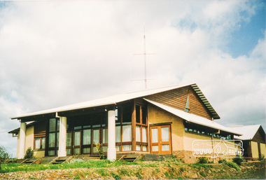 Eltham District Historical Society Inc
Photograph, Emergency Operations Centre, S.E.S., Kangaroo Ground
In 2017 known as the Kangaroo Ground Operations Centre a facility for hire managed by the Shire of Nillumbik. On 7 February 2009 (Black Saturday) the CFA Incident Control Centre (ICC) was located here. Described in "Worst of Days: Inside the black Saturday firestorm" by Karen Kissane (access via Google books): "..the ICC is part of a mud brick complex built in the 1980s as an emergency operations centre for several agencies, including the State Emergency Service. It is also home to the headquarters of the CFA's Lower Yarra Group. A small office with a whiteboard would be the incident controller's office throughout the office, but a larger central room, with data projectors, "smart boards" and maps would house the rest of the team.."Statement of Significance From the Victorian Heritage Database (2010) What is significant? The 1988 emergency operations centre and the surrounding site to the title boundaries. How is it significant? The emergency operations centre is architecturally, aesthetically, socially and historically significant to the Shire of Nillumbik. Why is it significant? The emergency operations centre is architecturally and historically significant as a good and rare example of a large public building constructed in a 1980s version of the 'Eltham style', and as a rare attempt to adapt the 'Eltham-style' aesthetic to meet the changing demands of the Shire in the 1980s (Criteria B, D & E). The emergency operations centre is architecturally and aesthetically significant because it is constructed of mud brick and features: a central entry with a tile mural (Criterion E). The emergency operations centre is socially significant because it is a focal point for the community and has played an important role in protecting the community since 1988 (Criterion G).Two colour photographs of mud brick Emergency Operations Centre building, Kangaroo Groundbuildings, mud brick, emergency centre, kangaroo ground -
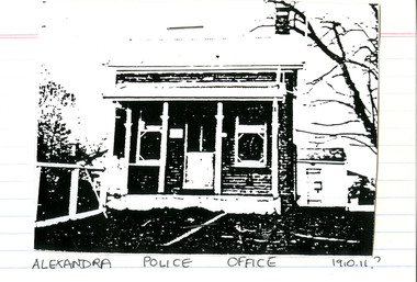 Victoria Police Museum
Police Stations (Alexandra)
Alexandra is a regional centre in the Shire of Murrindindi in Victoria, Australia and 130 kilometres north east of Melbourne. Alexandra Police Station opened in the Benalla Police District on 8 May 1867 in Bon Street, on the north side near Grant Street. When the station opened it was staffed by one Senior Constable; one 1st Constable (Mounted); one Foot Constable. The original building was a nine-roomed brick building with an iron roof on land measuring 84' x 97’. The house included a wash-house, pantry, bathroom, office, one W.C., stabling for three horses, a lock-up with two rooms and a single man's room. It closed in June 1977 and was replaced by a new police station which opened on 16 June 1977 in Bon Street, on land adjacent to the old police station. For a list of Officers in Charge 1871 to 1943 contact Victoria Police Museum1 black and white photo and 3 colour photospolice stations; alexandra police station -
 Victoria Police Museum
Police Stations (Altona)
Altona is a suburb of Melbourne, 13 km south-west of Melbourne's CBD and located within the City of Hobsons Bay Altona Police Station opened as a temporary police station in 1919 in the Melbourne District. It was on the corner Sargood and Blyth Streets. It was staffed by one 1st Constable. The original police station was in a small room attached to the front of a 5-roomed weather-board dwelling with an iron roof on land measuring 66' x 165'. There was also a kitchen, vestibule, wash-house, office, one W.C. and a lock-up. In 1929 it became part of the Bourke District. On 31 March 1958 it moved into newly built government premises at 51-53 Blyth Street, on the corner of Bent Street. The building consisted of a cream brick veneer police residence and police station with cell. Staff was increased to a Sergeant in Charge and 3 Constables. A new police station was opened in Altona North on 7th October 1979. The Altona Police Station remained as a sub-station for a few a short time until the building was sold. July 2019 - a new police station is being constructed at 1 Galvin Street, Altona. Galvin Street was names after S/C Michael Arthur Galvin, 3651, who was appointed on 5 Jan 1886 and resigned on 4 Dec 1913. He was Werribee Shire President 1926-1927 and 1940-1941 8 black and white photos of new police station, 1963police stations; altona police station -
 Victoria Police Museum
Police Stations (Apollo Bay)
Apollo Bay is a coastal town in southwestern Victoria. It is situated on the eastern side of Cape Otway, along the edge of the Barham River and on the Great Ocean Road, in the Colac Otway Shire. The original township was surveyed in 1853 and named Middleton. In 1881 the town was renamed Krambruk which was changed to Apollo Bay in 1898. The Krambruk Police Station was opened on 7 March 1888 in the Southern District on land opposite the site of the current Mechanics' Institute and changed its name to the Apollo Bay Police Station on 1 September 1990. It came under the Barwon District in 1948 and "Lima" Western District from 4 March 1990. In 1930 the police station was located to 29 Nelson Street. It was a seven-roomed weather-board dwelling on three-quarters of an acre of land. It consisted of six rooms of pine, lined and painted; one pantry; one bathroom and wash-house; one hall; one office and one W.C.. There was stabling for one horse and one cell for prisoners. It was staffed by one Mounted Constable. In the early 1970s land was acquired at 31 Nelson Street and a new police station was constructed. This was a three-roomed brick building with a cell block at the rear. By the time it closed in 2005 it had been extended twice. On 17 November 2006 the current Apollo Bay Police Station opened in its current location at 35a Nelson Street, on the corner of Cartwight Street). Outside the peak summer season, the station is open 16 hours per day and staffed by one sergeant and five other members. 3 black & white photos and 2 coloured photospolice stations; apollo bay police station -
 Victoria Police Museum
Police Stations (Ararat)
Ararat is a city in south-west Victoria, Australia, about 198 kilometres west of Melbourne, on the Western Highway on the eastern slopes of the Ararat Hills and Cemetery Creek valley between Victoria's Western District and the Wimmera. It is named after Mount Ararat 10 kilometres south-west of the town. A police station opened in Ararat in 1859, though there was a police presence in the area formerly known as Cathcart, Canton Lead and later Mount Ararat. In 1861 staff consisted of 1 Superintendent, 2 Mounted Constables, 1 Sergeant 2nd class, 1 Senior Constable, 8 Constables. The police reserve was on land bounded by Ligar Street, Barkley Street, Ingor Street and High Street. In 1930 the police station was described as a six-room brick dwelling with a slate roof, situated on one quarter acre of land. There was also a bathroom, wash-house, pantry, office, muster room and quarters for a single constable, stables with three stalls, and a lock-up consisting of two six-person cells. Later residences were located at 3 Ligar Street (brick veneer with a tile roof); 32A High Street (brick veneer with tile roof); and 3 Tobin Street (wood with an iron roof). A new, purpose built police station was opened in October 2010 at 77 Barkly Street. The Ararat Police District was reformed into the Wimmera Police District in 1870. Ararat Police Station became part of "R" (Glenelg) District in January 1948 and "M" (Highlands/Wimmera) District from March 1990. A list of police stationed at Ararat from 1903 - 1930 is available from the Victoria Police Museum8 photos comprising: 7 black & white photos 1 colour photopolice stations; ararat police station -
 Victoria Police Museum
Police Stations (Armadale)
Armadale is an inner suburb of Melbourne, Victoria, Australia, 7 km south-east of Melbourne's Central Business District, located within the City of Stonnington local government area. Armadale Police Station opened, in Melbourne Police District, on 11 May 1885. Its original location is unknown, but in 1890 it is listed in the Sands & McDougall directory as at 295 Hight Street. From 1985-1920 it was located at 20/22 Auburn Grove, 1925-1930 at 769 High Street and 1935-1946 at 3 Cheel Street. The station closed on 28 January 1946. The sub-division east of Orrong Rd was incorporated into Malvern Sub-district and west of Orrong Road into Prahran Sub-district. In a special 1930 issue of the Victoria Police Gazette the Armadale Police Station was described as a seven-roomed brick dwelling with a tiled roof on land measuring 127' x 104' x 98'. There was also a bathroom and W.C., a wash-house, office, and a lock-up (one cell). This is probably a description of the Cheel Street police station. It was staffed by one senior constable and three foot constables.12 photographs comprising 8 coloured images and 4 black and white images 1 sketch plan of Old Armadale Police Stationpolice stations; armadale police station -
 Victoria Police Museum
Police Stations (Ascot Vale)
Ascot Vale is an inner suburb 6 km north-west of Melbourne, Victoria, Australia in the local government area of the City of Moonee Valley. Ascot Vale police station was opened on 31 October 1887 in the Melbourne Police District. From 1900-1905 it was located at 54 Parade, Ascot Vale; from 1910-1925 at 71 St Leonards Road; from 1930-1953 at 37 St Leonards Road. In 1953 it was relocated to government owned premises at 111 Union Road until the police station closed on 1st May 1970 and the Sub-district was divided between Flemington and Moonee Ponds police stations. The former police station was used by the Crime Car Squad until about 1987 when the premises were damaged by fire. The police station at 37 St Leonards Road was described as a six-roomed brick dwelling with slate and iron roof on land measuring 150' x 50'. There was also a bathroom and W.C., wash-house, office and lock-up with one cell. It was staffed by one second-class sergeant and four foot constables. The purpose-built police station at 111 Union Road included a four-roomed residence with the exterior clad in rough cast Conite and a tile roof. There was also a kitchen, bathroom, laundry and separate garage. 4 black and white photospolice stations; ascot vale police station -
 Warrnambool and District Historical Society Inc.
Functional object - Brick, 94 Merri Street Warrnambool, Circa 1850
... District as an excellent substitute for fire bricks. The house ...The building at 94 Merri St is amongst the earliest buildings in Warrnambool. It was possibly constructed before 1854 and maybe as early as 1848. The original building consisted of four main rooms under a hip roof. The outer walls were masonry , apparently rubble The Heritage Council indcate that on the balance of probabilities this was the general store of Richard Osbourne and John Moffat Chisholm built in 1847-48.The building at 94 Merri Street had historical and architectural significance to the state of Victoria. It was a rare example of surviving, pre separation building with associated interest in its materials and components It is associated with Richard Osbourne who founded the Warrnambool Examiner(1851_1889) and the town’s first historian. Architecturally, the significance of the house lay in the hand -wrought timber framing. All the major timbers in this building had been hand sawn. The Gold rush of the 1850’s saw this process mechanised. A kitchen fireplace in the rear skillion included a large block of Merri Creek Mudstone, a combination of “tufa” and clay that was used in the Warrnambool District as an excellent substitute for fire bricks. The house was demolished in 2011 and items of significance were salvaged, this brick being one. While some bricks were imported, there is evidence that there were a number of brick burning businesses in operation around this time. However it is difficult to ascertain to which group this brick belongs. Red clay rectangular brick. Contains some small gravel like material, possibly ferrous buckshot, grey mortar remnants on side and diagonal crack along one side.warrnambool, 94 merri street, richard osbourne, john moffat chisholm, hand sawn timber, brick, building materials -
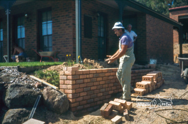
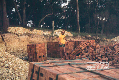 Eltham District Historical Society Inc
Photograph, Peter Vermey in excavation for garage with with stacks of bricks
14 Stokes Place (Lot 83) was the home of Peter and Carla Vermey. The land was purchased in May 1979 and construction commenced September 1979. The home was built by Peter and Carla Vermey after the developer, Macquarie Builders went bankrupt. Sold October 2017 by Morrison and Kleeman Real Estate. Stokes Place was part of the Stokes Orchard Estate which was developed from the break-up of the the orchard owned by Frank Stokes who lived on the northeast corner of Nyora Road and Eucalyptus Road. His daughter Beryl advised that the Shire had levied a rate assessment on individual parcels of land within the orchard which became unaffordable resulting in its sub-division and sell off. The Stokes Orchard Estate was developed by Macquarie Builders in two stages starting with stage 1 in 1976. Stokes Place was part of Stage 2 in 1979. The Estate was bounded between Nyora Road, Eucalyptus Road, Diosma Road and Stokes Place. The original orchard only just reached the left most portions of Stokes Place and did not go fully up to Diosma, rather to just beyond the extant of Stokes Place. Stokes Place was known within the family as "The Oats" as that is where they grew oats. Frank Stokes moved to Eltham c.1945 after visiting Harold Bird to view his orchard, located diagonally opposite Stokes Orchard from the intersection of Eucalyptus Road, Pitt Street and Nyora Road. It was on Harold Bird's recommendation that Frank purchased the land.The Stokes Orchard Estate collection is typical of housing developments of the late 1970s and 1980s. It was one of the earliest estates in Eltham following the nearby Woodridge Estate development.Digital fileScanned by EDHS from 49 x 35mm colour transparencies provided on loanstokes place, eltham, stokes orchard, stokes orchard estate, streets, houses, peter and carla vermey -
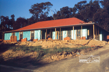 Eltham District Historical Society Inc
Photograph, House from front, being bricked
... provided on loan Digital file House from front, being bricked ...14 Stokes Place (Lot 83) was the home of Peter and Carla Vermey. The land was purchased in May 1979 and construction commenced September 1979. The home was built by Peter and Carla Vermey after the developer, Macquarie Builders went bankrupt. Sold October 2017 by Morrison and Kleeman Real Estate. Stokes Place was part of the Stokes Orchard Estate which was developed from the break-up of the the orchard owned by Frank Stokes who lived on the northeast corner of Nyora Road and Eucalyptus Road. His daughter Beryl advised that the Shire had levied a rate assessment on individual parcels of land within the orchard which became unaffordable resulting in its sub-division and sell off. The Stokes Orchard Estate was developed by Macquarie Builders in two stages starting with stage 1 in 1976. Stokes Place was part of Stage 2 in 1979. The Estate was bounded between Nyora Road, Eucalyptus Road, Diosma Road and Stokes Place. The original orchard only just reached the left most portions of Stokes Place and did not go fully up to Diosma, rather to just beyond the extant of Stokes Place. Stokes Place was known within the family as "The Oats" as that is where they grew oats. Frank Stokes moved to Eltham c.1945 after visiting Harold Bird to view his orchard, located diagonally opposite Stokes Orchard from the intersection of Eucalyptus Road, Pitt Street and Nyora Road. It was on Harold Bird's recommendation that Frank purchased the land.The Stokes Orchard Estate collection is typical of housing developments of the late 1970s and 1980s. It was one of the earliest estates in Eltham following the nearby Woodridge Estate development.Digital fileScanned by EDHS from 49 x 35mm colour transparencies provided on loanstokes place, eltham, stokes orchard, stokes orchard estate, streets, houses, peter and carla vermey -
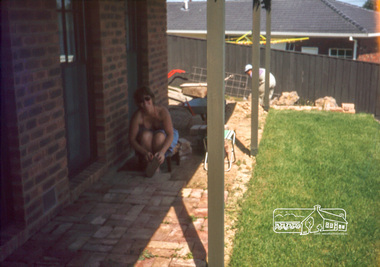
 Eltham District Historical Society Inc
Photograph, Nick building brick wall along driveway, February 1982
14 Stokes Place (Lot 83) was the home of Peter and Carla Vermey. The land was purchased in May 1979 and construction commenced September 1979. The home was built by Peter and Carla Vermey after the developer, Macquarie Builders went bankrupt. Sold October 2017 by Morrison and Kleeman Real Estate. Stokes Place was part of the Stokes Orchard Estate which was developed from the break-up of the the orchard owned by Frank Stokes who lived on the northeast corner of Nyora Road and Eucalyptus Road. His daughter Beryl advised that the Shire had levied a rate assessment on individual parcels of land within the orchard which became unaffordable resulting in its sub-division and sell off. The Stokes Orchard Estate was developed by Macquarie Builders in two stages starting with stage 1 in 1976. Stokes Place was part of Stage 2 in 1979. The Estate was bounded between Nyora Road, Eucalyptus Road, Diosma Road and Stokes Place. The original orchard only just reached the left most portions of Stokes Place and did not go fully up to Diosma, rather to just beyond the extant of Stokes Place. Stokes Place was known within the family as "The Oats" as that is where they grew oats. Frank Stokes moved to Eltham c.1945 after visiting Harold Bird to view his orchard, located diagonally opposite Stokes Orchard from the intersection of Eucalyptus Road, Pitt Street and Nyora Road. It was on Harold Bird's recommendation that Frank purchased the land.The Stokes Orchard Estate collection is typical of housing developments of the late 1970s and 1980s. It was one of the earliest estates in Eltham following the nearby Woodridge Estate development.Digital fileScanned by EDHS from 49 x 35mm colour transparencies provided on loanstokes place, eltham, stokes orchard, stokes orchard estate, streets, houses, peter and carla vermey -
 Eltham District Historical Society Inc
Photograph, Carla Vermey under front verandah cleaning bricks, February 1982
14 Stokes Place (Lot 83) was the home of Peter and Carla Vermey. The land was purchased in May 1979 and construction commenced September 1979. The home was built by Peter and Carla Vermey after the developer, Macquarie Builders went bankrupt. Sold October 2017 by Morrison and Kleeman Real Estate. Stokes Place was part of the Stokes Orchard Estate which was developed from the break-up of the the orchard owned by Frank Stokes who lived on the northeast corner of Nyora Road and Eucalyptus Road. His daughter Beryl advised that the Shire had levied a rate assessment on individual parcels of land within the orchard which became unaffordable resulting in its sub-division and sell off. The Stokes Orchard Estate was developed by Macquarie Builders in two stages starting with stage 1 in 1976. Stokes Place was part of Stage 2 in 1979. The Estate was bounded between Nyora Road, Eucalyptus Road, Diosma Road and Stokes Place. The original orchard only just reached the left most portions of Stokes Place and did not go fully up to Diosma, rather to just beyond the extant of Stokes Place. Stokes Place was known within the family as "The Oats" as that is where they grew oats. Frank Stokes moved to Eltham c.1945 after visiting Harold Bird to view his orchard, located diagonally opposite Stokes Orchard from the intersection of Eucalyptus Road, Pitt Street and Nyora Road. It was on Harold Bird's recommendation that Frank purchased the land.The Stokes Orchard Estate collection is typical of housing developments of the late 1970s and 1980s. It was one of the earliest estates in Eltham following the nearby Woodridge Estate development.Digital fileScanned by EDHS from 49 x 35mm colour transparencies provided on loanstokes place, eltham, stokes orchard, stokes orchard estate, streets, houses, peter and carla vermey -
 Ringwood and District Historical Society
Historical Document, Henrietta C. Walker, A House in the Foothills, 2-Mar-31
Wombolano Park was purchased by Henrietta and Frank Walker, who made many improvements to the house and garden.Article in the Australian Home Beautiful of 2-Mar-1931 about Wombolano homestead and property at Ringwood East. Pages 12,13,14,19,20,21. +Additional Keywords: Walker, Henrietta and Frank Walker"A House in the Foothills" article in The Australian Home Beautiful, 2 March 1931, pp. 12-14 and "Brick-work in the Garden" article in The Australian Home Beautiful, 1 April 1931, pp. 19-21. -
 Ringwood and District Historical Society
Photograph, Photos of last houses to face demolition at Camberwell. c1970s, c1983
One of the last houses to face demolition.Single fronted weatherboard with striped veranda blind, brick chimney over front rooms with TV aerial. Green painted walls. Red painted iron roof over veranda and under veranda rail. Adjacent to Target entrance.The 'Miss Stayput' house in the car park out the front of Target in Camberwell. You can even see the Target logo on the building. The house was owned by Mary Campigli, who defied the council order to move, and won her case in court. She stayed in the house, surrounded by a car park until she died in 1983 at the age of 94. The house was finally demolished soon after. -
 Ringwood and District Historical Society
Letter, Property for sale - Ringwood Shop and Dwelling Estate, Ringwood, Victoria - circa 1925
ID 5225 note: Further information relating to allotments marked on the hand-drawn plan are included in ID 5224 - Ringwood Station Estate.Typewritten letter from A.V. Greenwood with hand drawn plan of Ringwood Shop and Dwelling Estate, detailed description of property for sale, and top and side elevation views of house. (7 pages)(Transcript of first page - to unknown recipient) Phone 988 Central, 331 Canty Greenwood Pty. Ltd. 5 Flinders Street Melbourne. Dear Sir, 1. Attached please find drawings of my house at Ringwood. 2. It is for sale at £4,865 or to let at £5 per week to an approved tenant. 3. I sold it to Mr. De Garis and vacated it, but it is now back on my hands. 4. I leased another place instead of living in my own. I may be able to cancel same; in the meantime, however, I propose to sell or let my own. The painters are now going through the place; re-varnishing, re-oiling and re-polishing so that in about five days it will look "spick and span". 5. The house was specially built under my own supervision. 6. It is very suitable for a high class Guest House, Doctor's residence, Hospital or Convalescent Home. If you know of anyone whom it might suit, please communicate with them. DESCRIPTION 7. It stands on 305 feet of land facing Greenwood Avenue. It is cement, roughcast and hardwood, well oiled, and is now being redone so that the house is as good as new; red tile roof; verandahs three sides; two sleep-outs; five bedrooms; large dining room; very large music room with nooks, upstairs lounge, study; sewing room; built-in wardrobes and cupboards throughout; handsome kitchen with handsome pantry cupboard with drawers and glass front; one bath room; one shower room; wash house with patent copper and laundry. Every modern convenience, hot water system (through copper pipes with large copper cylinder) electric lights everywhere, outside and in, Yan Yean water laid on everwhere throughout house and gardens. Floors throughout are the very best, close set, stained and polished; dainty lead light windows etc. 8. There is a big garage, with tiled roof and two rooms with all conveniences for a married couple. Property is well drained with a system of its own. The house stands upon the top of a hill close to Railway Station, say 500 feet from the Footbridge. 9. The garden has expansive shrubs; sheds; fernery; tennis court. 10. A handsome piece of furniture goes with the house; a combination pantry and storeroom for groceries, milk, bread etc., consisting of drawers, glass and wire doors, as mentioned above. 11. It is within easy distance of Melbourne as it is only two minutes from Ringwood Station, which is a frequent electric train service bringing it within 39 minutes of the City. It is thought better by some to go further out into the country atmosphere and walk a short distance at the end than to go by train 20 minutes then walk 15 to 20 minutes. 12. The price quoted of £4,865 is made up as follows - 305 feet of land @ £5 ... £1,515 Garage and dwelling ... £300 House hot water system, American cupboard ... £2,600 Water, fencing, sheds & drain ... £250 For the lot ... £4,865 Should you require copies of the enclosed drawings I shall be pleased to supply same. 13. Mr. J.B. McAlpin is the local agent, Phone Ring. 7 (after hours Ring. 44) or you may phone me Central 988. 14. The house is south of the line, facing Greenwood Avenue and immediately at the back of Ringwood House, which is also my property. Yours sincerely, A.V. Greenwood (illegible) ..... (Transcript of second page) RINGWOOD SHOP AND DWELLING ESTATE See these letters on plan attached (H.) Ringwood House and Shops on 100 by 150 feet of land fronting Bedford Road 100 feet @ £10 per foot - £1,000 House and shops - £2,400 ... £3,400 Ringwood House consists of Boarding House, (Phone 101) and two shops, mainly brick; 9 inch walls. Will carry another story. Has music room, dining room, entrance halls, 10 bedrooms, large verandahs, all conveniences, hot and cold water, and stands on what will become a most valuable business corner. (F.)(G.) Mr. Greenwood's house, garage and sheds, stands on 307 feet of land fronting Greenwood Avenue. See detailed description attached ... £4,865 (J.) Cottage on Block 81 in William Street ... £750 (K.) Cottage in Pitt Street ... £650 (Total) £9,665 ..... (Description of third page - Subdivision Plan) Drawn by Edyth Greenwood, phone 988 Central. Subdivision includes Station Street, Pitt Street, Bedford Road, Wantirna Road, James Street, William Street (later Kendall Street), Greenwood Avenue, Ellison Street, and Haig Street. Circles denote blocks for sale. Squares denote house properties for sale. Other features marked include location of businesses along Main Street (Maroondah Highway), cool store, railway station, shop and police station on Bedford Road, church on Station Street, site of schoolmaster's residence and State School, and location of proposed public baths -
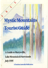 Marysville & District Historical Society
Ephemera (Item) - Tourist Guide, Graeme Haycraft, Mystic Mountains Tourist Guide July 1995, 07-1995
A tourist guide outlining services, accommodation, activities and places of interest to visit in and around Marysville, Lake Mountain and the local district.A tourist guide outlining services, accommodation, activities and places of interest to visit in and around Marysville, Lake Mountain and the local district.Acknowledgements/ Mystic Mountains Tourism Association, Marysville Office of the Dept. of Conser/ vation & Natural Resources, Mrs Elaine Postlethwaite, Ms Sue Henry & every/ advertiser without whose support this Guide would not have been possible.marysville, victoria, australia, tourist guide, mystic mountains, lake mountain, tourism australia, graeme haycraft, magic creek nursery, missing links miniature golf, phelps bakery, blackwood cottages, marysville hotel motel, tower motel, kerami house, marylands guest house, lomatia lodge, willowbank at taggerty, barree mud brick cottages, scenic motel, somerled mountain retreat, dalrymples guest cottages, nanda binya lodge, mathilde's of marysville country guest house, the birches resort, mystic mountains tourist information, marysville caravan park, the cumberland, igloo roadhouse, top shop pancake parlour, the silver birch restaurant, steavenson's restaurant, olde yarra track shoppe, danish coffee gardens, oscars take-away, country touch pottery studio & gallery, cumberland memorial scenic reserve, cathedral range state park, lady talbot forest drive, wishing well, taggerty river picnic area, taggerty river, phantom falls, keppels falls, the beeches walking track, mount sugarloaf, maryton park holiday cottages, snowviews, esa camping & conference centre, wirreanda festival, marysville post shop, hidden talent craft gallery, marysville automotive repairs, geoffrey pope & associates, beauty spot walk, tree fern gully walk, michaeldene track, marysville riding school, gerraty's ski centre, marysville holiday cottages, marysville triangle taxi service, fruit salad farm, lake mountain alpine resort, marysville ski hire, lake mountain ski school, cross country ski hire, lake mountain ski hire, marysville country club