Showing 1811 items matching "planning and development"
-
 Melton City Libraries
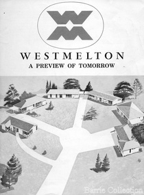
Document, West Melton: A preview of tomorrow, c.1969
"In April 1969, the first major residential development in Melton began with the release of 148 homes for purchase. This was the first stage of a staggered release of a planned 30,000 homes for 100,000 people by 1990. The development, called Westmelton Satellite City, was described as ‘a preview of tomorrow’.101 It was the first estate built in a ‘modern’ style, with curved streets, and dozens of culs de sac. Westmelton was also the first major development in Victoria to build all the supply lines to the houses – including electricity and telephone lines – underground. The six different home designs in Westmelton were ‘specially designed for the future’, and with allotments ten feet wider than regulations required, there was plenty of ‘space for gracious living’ and for a family swimming pool. The developers of this new estate were active in promoting Westmelton as a new community within the Shire of Melton. By 1971, the Westmelton City News reported that Ian McIntosh, General Manager of Westmelton, had given away $100,000 on behalf of the company ‘to aid community projects’. This included a $72,000 donation towards building a community centre in Westmelton, and $25,000 for the shire’s Olympic-sized swimming pool. Ian McIntosh and his family moved to Melton and Ian said he was ‘very much aware of the needs of [the] Westmelton community’. By the end of 1971, Westmelton was home to 100 new families. The modern residences were obviously an appealing drawcard, but so was the country feel that characterised Melton. Mrs C. Allen, described as a ‘housewife’, said she and her husband chose to move to Westmelton because of ‘the quality homes ... and we both love the clean, fresh, natural environment that surrounds us’. Similarly, Mr W. Coxhead, insurance consultant, moved to Westmelton because of the ‘clean, fresh country air’. Accountant Mr B. Swanton echoed their sentiments, describing Westmelton as ‘far enough away from the industrial pollution carried over Melbourne suburbs by prevailing westerly winds’. The new development attracted an increasing number of young, professional couples and families, representing the beginning of a significant shift from the predominantly rural and farming community of the district’s past. The Westmelton development had four different ‘neighbourhoods’ designed to cater to a variety of different lifestyle needs. Westmelton was the first to be established, followed by Brookfield, which offered ‘superb land in a rustic setting’. Brookfield Acres offered ‘wide open spaces with lots of room for a pool and even a tennis court’ on huge one-acre blocks, while Westlake was an innovative development with ‘different sized homesites’ and ‘lakeside living’.Westmelton was the first of many residential developments that would come to play a huge role in shaping the shire in the decades to follow".A marketing brochure for the Westmelton Satellite City developmentlocal significant events, council -
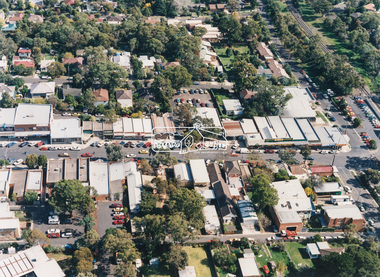
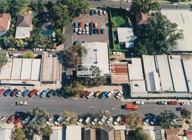
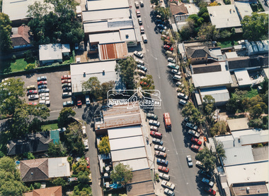
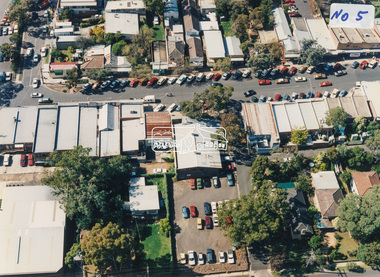
 Ringwood and District Historical Society
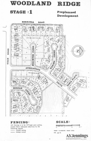
Flyer - Land Sale, Preplanned Development - Woodland Ridge Estate Stages 1, 2 and 3, Ringwood North, Vic. - circa 1972
Subdivison maps of Woodland Ridge Estate. Stage 1 includes Berringa Road, Oban Road, Athelstane Drive, Braimton Close, Karima Court, Tania Place, Runyan Court. Stage 2 includes Athelstane Drive, Cormiston Road, Linda Place, Casula Place, Oban Road. State 3 includes Williams Road, Athelstane Drive, Tania Place and Cormiston Road. Developer - A.V. Jennings Industries (Aust) Ltd., 690 Springvale Road, Mulgrave, 3170. Phone 560 8411. Supplementary page with early 2000s sale prices for eight addresses - 16 Athelstane Drive Ringwood 3134 $210,000 4/4/2000 19 Athelstane Drive Ringwood 3134 $235,000 14/1/2000 27 Cormiston Road Ringwood 3134 $246,000 28/10/2000 1 Runyan Court Ringwood 3134 $183,000 2/5/2001 4 Runyan Court Ringwood 3134 $179,000 14/8/2000 11 Runyan Court Ringwood 3134 $193,000 28/4/2000 7 Runyan Court Ringwood 3134 $187,500 14/1/2000 4 Casula Place Ringwood 3134 $216,000 13/2/2001 Accompanying handwritten notation by Richard Carter R.E.S.I. - "Purchaser of 'Pre-planned Development' lots also agreed to purchase the house planned for the lot. Bramton Court "Witheld" for display homes. Stage 3 one acre sites drained north therefore not readily sewered." -
 Bendigo Military Museum
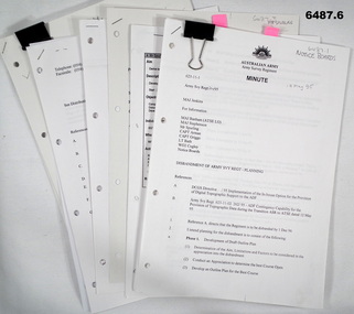
Document - Disbandment of Army Survey Regiment Planning 1995, Army Survey Regiment, Bendigo, December 1995
... Disbandment of Army Survey Regiment Planning 1995 ....1 Disbandment of Army Survey Regiment (ASR) Planning19 May 1995. Reference A - DCGS Directive /95 Implementation of the In-house option for the provision of Digital Topographic Support to the ADF. Reference B - Army Svy Regt 623-11-02 262/95 ADF Contingency Capability for the Provision of Topographic Data during the transition ASR to ATSE dated 12 May 1995. Reference A directs the ASR to be disbanded by 1 Dec 1996. Planning for the Disbandment is to consist of the following: Phase 1 - Development of Draft Outline Plan (1) Determine the Aim, Limitations and factors to be considered in the appreciation into the disbandment, (2) Conduct an appreciation to determine the best course of action, (3) Develop an Outline Plan for the Best Course of Action. (4) Brief DSVY-A and staff on the proposed Outline Plan. Phase 2 - Review of the Outline Plan by DSVY-A and issue further guidance. Phase 3 - Develop the Detailed plan including project management strategy. The disbandment is to achieve the smooth transition of operational responsibility to ATSE. The responsibility and resources to maintain the Minimum Operational Capability outlined in Reference B is to be formally passed to ATSE prior to disbandment. Proposed timings: Phase 1 completed by 1 Jun 95, Phase 2 completed by 15 Jun 95, Phase 3 complete d by 30 Jun 95, Disbandment completed by no later than 1 Dec 96 (Executive Order). All postings, administration and stores and equipment returns are to be completed by this date. .2 Disbandment of Army Survey Regiment Planning Report 26 May 1995 - Develop possible courses of action for the disbandment of ASR with reference to Technical, Historical and Union Issues by 6 Jun 95. .3 Disbandment of Army Survey Regiment Disbandment Team 26 May 1995 - Allocation of Team Members and responsibilities. .4 Disbandment of Army Survey Regiment May 1995 - Minimum Contingency Technical Equipment List for transition to ATSE. .5 Disbandment of Army Survey Regiment Plan 23 Aug 1995 - During the transition period (1 Jul 95 - 1 Dec 1996) leading to the full implementation of the Preferred In House Option (PIHO) Army Svy Regt and ATSE will at all times operate concurrently whilst Army Svy Regt scales down production and progressively transfers all technical functions to ATSE. Army Svy Regt will continue programmed production activities at best endeavor until declared operationally ineffective. During the transition to ATSE a contingency mapping capability is to be maintained. .6 Directorate of Survey - Army Commercial Support Program Digital Topographic Support to the ADF In-House Option Directive Dec 95. This directive defines the CSP contract management arrangements between the contract Administrator (DSVY-A) and the Contractor (ATSE) for the implementation and operation of the IHO for digital Topographic support to the ADF. .1 Disbandment of Army Survey Regiment Planning19 May 1995 - A4 paper clipped document, 4 x hole punched, 21 pages, diagrams and typed and hand written. .2 Disbandment of Army Survey Regiment Planning Report 26 May 1995 - A4 paper stapled document, 4 x hole punched, 9 pages, diagrams and typed and hand written. .3 Disbandment of Army Survey Regiment Disbandment Team 26 May 1995 - A4 paper stapled document, 4 x hole punched, 2 pages, typed. .4 Disbandment of Army Survey Regiment May 1995 - Minimum Contingency Technical Equipment for transition. A4 paper stapled document, 4 x hole punched, 2 pages, typed. .5 Disbandment of Army Survey Regiment Plan 23 Aug 1995 - A4 paper stapled document, 4 x hole punched, 10 pages, diagrams and typed. .6 Directorate of Survey - Army Commercial Support Program Digital Topographic Support to the ADF In-House Option Directive Dec 95. A4 paper clipped document, 4 x hole punched, 16 pages, diagrams and typed, hand written notes. royal australian survey corps, rasvy, fortuna, army survey regiment, army svy regt, atse, asr -
 Eltham District Historical Society Inc
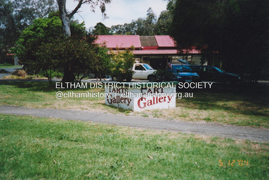
Photograph, Fay Bridge, Local humour added to Art Gallery sign, 559 Main Road, Eltham, 5 December 2004
Photo taken immediately after the Wiregrass gallery closed at the end of November. The property was purchased in October 2004 for $565,000 by a local investment company, Sentinel Equities run by local residents Jethro and Suzanne Still. Plans to redevelop the property into offices and a gallery designed by Robert Marshall and supported by a number of local artists met with opposition from Eltham Gateway Action Group in 2007 over the proposed new building size and insufficient parking provision given the proposed reliance on the VicRoads reserve on Main Road for parking. The development proposal was finally approved by VCAT in January 2008 subject to VicRoads approving the use of the road reserve for parking. That did not happen and the property remains undeveloped 15 years later (August 2023).fay bridge collection, 559 main road eltham, 2004-12-05, eltham, eltham gallery, graffiti, main road, wiregrass gallery -
 Queenscliffe Maritime Museum
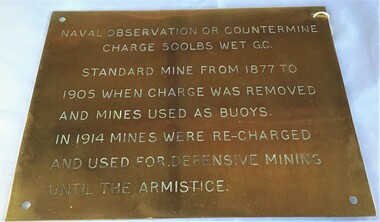
Plaque - Plaque, brass inscribed with Naval countermine information
Found in garden shed of Mr Harry Barratt [WWI Gallipoli] and donated by his grandson. In 1877 Swan island was designed to defend shipping in Port Phillip and Hobson's Bays. The scheme, involving massive expenditure, comprised a forward defence system of forts at Port Phillip heads dominated by Fort Queenscliff and South Channel Fort (artificial island), and a network of coastal batteries. Some development of fortification had occurred in the 1850s, but it was the impetus of the Jervois-Scratchley reports which led to major work being undertaken in the 1880s. The overall defence plan involved a combination of guns, mines (known as electric torpedo) and ships to defend the entrance to Port Phillip Bay. Swan Island Fort would be used to protect the minefields in the harbour, Naval observation countermine charge 500lbs wet G.C Standard mine from 1877 to 1905 when charge was removed and mines used as buoys. In 1914 mines were recharged and used for defensive mining until Armistice.Brass plaque inscribed with information on naval countermineNaval observation or countermine charge 500lbs wet G.C. Standard mine from 1877 to 1905 when charge was removed and mines used as buoys. In 1914 mines were recharged and used for defensive mining until the Armistice.sea mine, plaque, pre wwi, naval countermine, swan island -
 Running Rabbits Military Museum operated by the Upwey Belgrave RSL Sub Branch
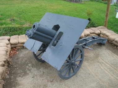
Skoda 7.5 cm Model 15, The Skoda 7.5 cm Gebirgskanone M15 mountain gun, 1911-1914
The Germans bought some guns during World War I, but used them as infantry guns in direct support of the infantry where their light weight would allow them to move with the infantry. They complained that the guns were too fragile and didn't have a high enough muzzle velocity to act as an anti-tank gun. Considering that the guns were designed to be disassembled it's not too surprising that they couldn't stand the abuse moving through the shell-pocketed front lines on the Western Front.This particular Gun was captured by Australian Soldiers at the Battle of ST Martins Wood near Ypres in the 3rd Battle for the Somme. The German crew were all killed as were a number of AustraliansThe Skoda 7.5 cm Gebirgskanone M. 15 was a mountain gun used by Austria-Hungary in World War I. In German service it was known as the 7.5 cm GebK 15. Its development was quite prolonged as the Austrians couldn't decide on the specifications that they wanted. Initially they wanted a gun that could be broken-down into no more than 5 pack-animal loads to replace the various 7 cm mountain guns in service, but prolonged trials proved that the 7.5 cm M. 12 prototype to be the best gun. The guns were delivered beginning in April 1915 instead of the planned date of April 1914. For transport, the gun could be dismantled into 6 parts, generally carried in 4 loads. In addition, there was a gun shield fitted on some (perhaps many) such guns. ypres st martins wood skoda gun -
 Bendigo Historical Society Inc.
Document - PETER ELLIS COLLECTION: COO-EE! SONGS OF THE ANZACS PROGRAM/ARTICLE RE PETER ELLIS
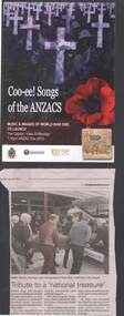
a. Program for the concert held at the Capital Theatre, View Street, Bendigo on 24th. April 2015, titled 'Coo-ee! Songs of the Anzacs' music and images of World War One and the launch of a double CD of the same name. The concert was organised by Peter Ellis, who also co-ordinated and produced the double CD. A similar concert was held at Goornong Soldiers' Memorial Hall on 24th.January 2015, also organised by Peter Ellis with the Goornong Hall Committee. The CD production was a joint effort between Peter and the Bendigo Historical Society, partly funded by a Federal Grant from the Anzac Centenary Grants. During the planning and development of the CD, Peter became ill with pancreatic cancer. He passed away within a month of the Concert at the Capital. B. The newspaper article tells of his funeral.event, war, concert capital, peter ellis, anzac, capital theatre -
 Falls Creek Historical Society
Journal - Schuss Vol. 24. No.3 May 1958
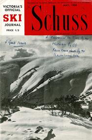
Schuss was advertised as Victoria’s Official Ski Journal It was issued monthly from 1935 to 1961 except during the war when summer issues covered two months. This continued after the war, but it averaged 10 issues annually over its 25 year life. Schuss was published by the Ski Club of Victoria which had a membership of 38 Ski Clubs and demanded to be recognised as the prime authority on skiing in the state. The other 30 ski clubs with 85% of the members disagreed and the politics of skiing became heated. These clubs formed the Federation of Victorian Ski Clubs with their own journal, Ski Horizon. With the establishment of the Victorian Ski Association, Ski-Horizon published its last issue in Nov - Dec. 1955 and the role of the official journal was fully taken over by “Schuss”. This item is significant because it contains stories, images and information documenting the development of the ski facilities at Falls Creek.The journal features stories and events chronicling developments in Victoria and internationally. The cover is a photo by Eric Burt captioned "Hotham Ski slopes which are already calling skiers for the '58 season" Page 87 has a brief report about the destruction of the Albury Ski Club by fire on 18th April 1958. The date of the N.E.D.S.A. Junior Championships to be held on Friday 5th September was announced so that school children had time to plan their holidays. Page 94 featured a column "Things happening at Falls Creek" written by Shirley Inglis. Page 125 announced that a second hive of bees had been found in the roof at Skyline Lodge during recent painting. Advertisements for the Falls Creek General Store and the Snow Crystal Inn managed by Milan Kovacic were included.schuss journal, the ski club of victoria, snow crystal inn, albury ski club fire -
 Eltham District Historical Society Inc
Photograph - Aerial Photograph, Montmorency Shopping Village, Were Street, Montmorency, 1994
Aerial photographs of Montmorency Shopping Village with a central focus on the former Montmorency Theatre and Bingo Hall situated at 41-43 Werte Street. In 1993 Eltham Shire Council issued a permit to Michael Muzur, Terry Lant and Andrew McMillan to redevelop the former Montmorency Theatre/Bingo Hall at 41-43 Were Street as an alcohol-free youth entertainment centre. Ron McCormack, retired former JP on behalf of 41 Joint Appellants consisting of local residents and traders successfully lobbied the community and won an Appeal to have the permit cancelled as unsuitable development. The Administrative Appeal Tribunal found that the proposed development came withing the Eltham Planning Scheme definition of an 'amusement parlour' and that the playing of pool an amusement machines would be the focus of the centre and unlikely to attract older age groups. The tribunal was not satisfied the applicants had sufficient knowledge or where with all required for the successful running of this type of operation. With respect to the objectors, the Tribunal did not accept that a responsibly managed and attractive amusement parlour could not coexist near the adjoining residential area and without detriment to the commercial centre. At a Council meeting on June 7, 1994 councillors requested a report outlining criteria to be used to assess planning applications for youth entertainment venues given the Tribunal's view that a poorly managed facility in a small neighbourhood shopping centre, particularly in such close proximity to a residential area would not only have the potential to increase perceived youth problems, but could jeopardise the prospects of future proposals. Ron McCormack moved to Montmorency from Coburg in the early 1980s and from then sat on the bench at Eltham Courthouse when Police requested assistance out of hours, until the eventuial closure of the Courthouse. montmorency theatre, montmorency bingo hall, 41-43 were street, youth entertainment centre, eltham shire council, planning permit, administrative appeals tribunal, ron f mccormack, aerial photograph -
 Bendigo Military Museum
Photograph - Detachment - Army Survey Regiment, Bonegilla, Victoria, c1973
This is a set of six photographs of personnel from the Detachment - Army Survey Regiment taken in front of its main map production building at Bonegilla, Victoria in c1973. This cartographic map production sub-unit of the Army Survey Regiment operated in buildings owned by the School of Military Survey from 17th of June 1970 to the 30th of September 1985. A total of 800 topographic maps ranging in scale from 1:25,000 to 1: 250,000 scale were completed. A major focus of production in the 1970s was the cartographic completion of the Papua-New Guinea 1:100,000 map series and the Flexiflow quality control system was developed as a tool to coordinate production. The Flexiflow system comprised a series of job plans and charts linked to a task allocation to resource magnetic planning board. Using critical path analysis and task prioritisation, complex job planning was efficiently scheduled, and re-prioritisations readily made. Reproduction requirements were effectively coordinated by way of weekly courier to the Army Survey Regiment at Bendigo. Supervisors and technicians fully embraced the system as they could understand their role, others around them and the positive production achievements. WO1 Bill Boyd (who does not appear in this photograph) was the technical warrant officer for 11 years at the Detachment was awarded the OAM, the Order of Australia Medal for leading the development and the implementation of the Flexiflow system. By mid-1982, production of maps at these scales was undertaken digitally on Bendigo’s AUTOMAP 2 system and the Detachment reverted to production of small-scale large format RAAF aeronautical charts. Detachment personnel managed to produce 18 charts in the following two years, which was an impressive achievement for the staff, given major differences in format, specification and scales. Development of digital production of aeronautical charts in 1984-85 led to gradual reduction in production output and contracting out production was instigated to meet the shortfall and as a consequence the Detachment closed in September 1985. See pages 177 to 180 of Valerie Lovejoy’s book 'Mapmakers of Fortuna – A history of the Army Survey Regiment’ ISBN: 0-646-42120-4. for more information on the history of the Detachment at Bonegilla.This is a set of six photographs of the Detachment - Army Survey Regiment taken in front of the main map production building at Bonegilla, Victoria in c1973. The photographs were printed on photographic paper and are part of the Army Survey Regiment’s Collection. The photographic print and proofs were scanned at 600 dpi. .1) to .3) - Photo, black & white c1973. Back Row L to R: Peter Simpson, Chris Edwards, unidentified (x2), Colin Harden, Rowan Gillies, Bob Rowley OAM, Steve Hansen, Stu Thaxter. Centre Row L to R: Kevin Boehm, Dennis McCarthy, Peter Cross, unidentified, Brian Ryan, unidentified, Ian Marner, unidentified, Phil Smalley. Front Row L to R: Geoff Haynes, Bruce Wetzig, Dave Thompson, unidentified, OC Bob Roche, Ike Lever, John McCulloch, Dick Barwald, unidentified. .4) - Photo, black & white c1973. Back Row L to R: Peter Simpson, Chris Edwards, unidentified (x2), Colin Harden, Rowan Gillies, Bob Rowley OAM, Steve Hansen, Stu Thaxter. Centre Row L to R: Kevin Boehm, Dennis McCarthy, Peter Cross, unidentified, Brian Ryan, unidentified, Ian Marner, Phil Smalley, unidentified, Dick Barwald. Front Row L to R: Geoff Haynes, Bruce Wetzig, Dave Thompson, unidentified, OC Bob Roche, Ike Lever, John McCulloch, unidentified (x2). .5) - Photo, black & white c1973. Back Row L to R: Geoff Haynes, unidentified, John McCulloch, Bruce Wetzig. Front Row L to R: Dave Thompson, Ike Lever, unidentified. .6) - Photo, black & white c1973. L to R: OC Bob Roche, unidentified.There are no personnel annotated.royal australian survey corps, rasvy, army survey regiment, detachment - army survey regiment, army svy regt, asr -
 Eltham District Historical Society Inc
Document, Prospectus: Kinloch Gardens, Eltham Victoria, 1998c
“Kinloch Gardens at Eltham, Victoria is planned as a comprehensively designed and cohesive residential environment.” “Only twelve innovatively designed houses ,will be situated within the established gardens and grounds of this historic Eltham estate. Building design and development will be under the control of the Kinloch Gardens design and construction team.” “Kinloch Gardens is situated on one of the highest points in Eltham and enjoys panoramic views in all directions.” “Kinloch Gardens lies hidden from the outside world behind high stone retaining walls, terraced embankments and extensive landscaping. The existing buildings, amongst the most significant of the Eltham / Montsalvat domestic building tradition are set in park like surrounds and enjoy panoramic views of the ranges to the north east and the city sky line to the west. New houses combined with sensitive landscaping will blend immediately into the established garden environment and will share the amenity and ambience of a very private and unique estate. The central theme of the landscape master plan is a garden reserve and a planted avenue terminating in a -small square.” “Houses vary in size from 120m2 (12.9 squares) to 210m2 (22.6 squares) (or larger) and include an extensive range of planning options. House types include: The Studio House The Tower House The Pergola House The Gallery House 'The Barn' is one of the existing buildings of Kinloch Gardens and is situated on the premium Lot 11.” Developer: Kinloch Pty Ltd. Project Managers: Creative Block Design Pty Ltd. Architects: Graeme Gunn and Ian Jelbart. Landscape Architect: Suzy Boyd. Builder: Vizarje Homes Pty Ltd. Surveyors and Engineers: Miller Merrigan.Digital file only; created from scan undertaken by EDHSarthur street, creative block design pty ltd., eltham, graeme gunn, houses, ian jelbart, kinloch gardens, kinloch pty ltd, miller merrigan, real estate, suzy boyd, vizarje homes pty ltd. -
 Eltham District Historical Society Inc
Document, Kinloch Gardens Property Album; Elders Real Estate sales material, 1998
“Kinloch Gardens at Eltham, Victoria is planned as a comprehensively designed and cohesive residential environment.” “Only twelve innovatively designed houses ,will be situated within the established gardens and grounds of this historic Eltham estate. Building design and development will be under the control of the Kinloch Gardens design and construction team.” “Kinloch Gardens is situated on one of the highest points in Eltham and enjoys panoramic views in all directions.” “Kinloch Gardens lies hidden from the outside world behind high stone retaining walls, terraced embankments and extensive landscaping. The existing buildings, amongst the most significant of the Eltham / Montsalvat domestic building tradition are set in park like surrounds and enjoy panoramic views of the ranges to the north east and the city sky line to the west. New houses combined with sensitive landscaping will blend immediately into the established garden environment and will share the amenity and ambience of a very private and unique estate. The central theme of the landscape master plan is a garden reserve and a planted avenue terminating in a -small square.” “Houses vary in size from 120m2 (12.9 squares) to 210m2 (22.6 squares) (or larger) and include an extensive range of planning options. House types include: The Studio House The Tower House The Pergola House The Gallery House 'The Barn' is one of the existing buildings of Kinloch Gardens and is situated on the premium Lot 11.” Developer: Kinloch Pty Ltd. Project Managers: Creative Block Design Pty Ltd. Architects: Graeme Gunn and Ian Jelbart. Landscape Architect: Suzy Boyd. Builder: Vizarje Homes Pty Ltd. Surveyors and Engineers: Miller Merrigan.Digital file only; created from scan undertaken by EDHSarthur street, elders real estate, eltham, kinloch gardens, real estate agent, the barn -
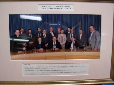 Glenelg Shire Council Cultural Collection
Photograph - Photograph - Portland City Council, 1991/92. Councillors and Corporate Team, 1992
Glenelg Shire Council RecordsColour photograph of 13 men and 2 women standing or seated behind a long curved table, in front of blue curtains.Front: Portland City Council, 1991/92 / Councillors and Corporate Team (top centre, typed). Left to Right: Back Row Standing - Cr. Robert Menzel, Ross Morgan (Director Technical Services), Cr. Bernard Wallace, Cr. Murray Box, Bill Hebb (Director Community Services) and Trevor Hornby (Director Corporate Services). Centre Row Standing: Cr. Bill Collett, Cr. Lynn Murrell, Cr. Keith Wilson and Lelia Pop (Town Planner). Front Row Seated - Greg Trevaskis (Chief Executive), Cr. Kay Frankcom, Cr. Jeffrey Baulch (Mayor), Cr. Michael Noske (Deputy Mayor) and Neil Buckingham (Director Planning & Development). -
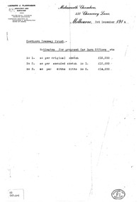 Melbourne Tram Museum
Drawing, Leonard J Flannagan, "Hawthorn Tramway Depot", 1915
Set of 7 drawings for the development of the concept and layout of the Hawthorn Tramways Trust depot by the Architect Leonard J Flannagan, of Molesworth Chambers, 450 Chancery Lane, Melbourne. Item numbers match with the relevant image. .1 - Photocopy of a memo on the Architect's letterhead of cost estimates of three different options - dated 3/12/1914. Has a "School of Architecture" on the bottom right hand corner of the sheet and a sticker "WD GAR.4-4" giving a reference document number. Printed on an A4 sheet. .2 - Copy print of a pencil drawing - "Hawthorn Tramways Trust - Sketch Proposed Car Barn - Original Design Scheme No. 1". Reference Number in the bottom left hand corner "WD GAR.4-1". .3 - ditto showing floor plans with title "Alternative Plan No. 1" - Reference Number "WD GAR 4-6". .4 - ditto, with notes about items to be added in bottom right hand corner - Reference Number "WD GAR 4-6". .5 - as for .2 - "Amended design scheme No. 2" - Reference Number "WD GAR 4-5" .6 - Contract drawing - showing the elevation of the depot to Wallen and Power Streets - drawing No. 72, has both the names of the architect and the engineer in the bottom left hand corner. Note - amended drawing dated 6-5-15. Reference Number "WD GAR 4-5". .7 - Contract drawings - showing the first floor plan, internal elevation and the western or depot front elevation - drawing No. 71. Reference Number "WD GAR 4-7".trams, tramways, htt, hawthorn, architects, depot -
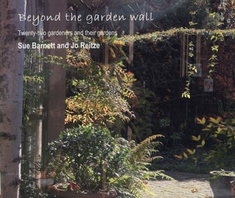 Surrey Hills Historical Society Collection
book, Beyond the garden wall: twenty-two gardeners and their gardens, 2008
This book was compiled by Sue Barnett at the request of the project participants from material gathered as part of the project "Beyond the Garden Wall". This project was devised and managed by a team at Surrey Hills Neighbourhood Centre Inc. with funding from the Victorian Department of Planning and Community Development (VDPCD) under the "Images of Age' grant 2007. It involved conducting oral histories, reflection on the part of the participants through visual diaries, photography and painting. A short video of some of the gardens was also commissioned. All the elements came together during Seniors Festival in an exhibition held at the Augustine Centre, and opened by Jane Edmanson. At the request of the VDPCD, a modified exhibition was held in 2008 at 'Australia on Collins' during the 2008 Seniors Festival. Sue Barnett and Jo Reitze (Mrs de Carteret) are Surrey Hills residents. This provides a snapshot of 20 gardens and the 22 passionate gardeners who created them. The prose provides a potted history of the gardeners and their philosophical approach, accompanied by portraits of them and cameo photos of their gardens, as well as a photo of the painting of the garden as seen by artist Jo Reitze. All the gardens were situated within the City of Boroondara and all the gardeners were over 60 years of age. Prose written by Sue Barnett; photography by Sue Barnett and Jo Reitze.gardening, anecdotes, (ms) jo reitze, (ms) susan barnett, sue barnett, paintings, gardeners -
 Vision Australia
Text, The Association for the Blind Illawarra Community Centre annual meeting minutes 24/9/1976 to 10/9/1993, 1976-1993
These meetings were held at the Illawarra Community Centre and the minutes include Present, National Anthem, Tributes, Apologies, Notice of convening the meeting, Life Governors, Confirmation of previous minutes and Reports from The Chairman, Financial. 1/10/1985 Mrs Heath, founding chairman of the Illawarra Community Centre highlighted that the Centre is based on a unique concept of integrating organisations which traditionally functioned in isolation. The outstanding success of the Centre at this time is consistent with the initial planning and development. At 1985 the Centre had the following user groups Association for the Blind (AFB), Better hearing Australia, Department of Community Services - Rehabilitation unit, Diabetes Found of Victoria, Epilepsy Foundation of Victoria, Paraplegic and Quadriplegic Association of Victoria, Social Organisation for the Handicapped, Victorian Deaf Society and Yooralla Society of Victoria. 2 paper registersassociation for the blind -
 Melbourne Tram Museum
Document - Report, Public transport Unions, "Metplan - Industry Unions - Briefing Paper No. 3 - Tram System Extensions", "Metplan Discussion Paper", 1987 to 1988
Set of four photocopied documents, A4 sheets, stapled in top left hand corner concerning the development and adoption of Metplan, a Metropolitan Public Transport Industry Plan - see Reg Item 1186 for a discussion paper. .1 - "Metplan - Industry Unions - Briefing Paper No. 3 - Tram System Extensions" - March 1988 - 16 sheets - one of series of four documents to give Public Transport Unions where the industry is heading over the 15 years project life period. document looks at the Docklands Light Rail in London and bus services through the Central district of Melbourne. .2 - "Metplan Draft Document - January 1988" - 5 pages - prepared by Martin Gray - December 1987 - looking at training, working conditions, employment security, station staff and service delivery and job opportunities. .3 - "Metplan Discussion Paper" - 3 sheets - gives an overview of the suburban system, union's role, what could be done, electrification, rail cars, station development, dual voltage systems. .4 - "Metplan Discussion Paper" - table looking at the various measures, percentage changes, Metplan issues, services, finance and extension options. See also Reg item 2809 for a August 1988 paper and 345 for a detailed report.trams, tramways, ptc, metplan, unions, buses, tramways, public transport, suburban and underground -
 Eltham District Historical Society Inc
Photograph - Digital Photograph, Jim Connor, Edendale Farm Homestead, 11 December 2014
Edendale Farm is Nillumbik Shire Council's environment centre situated in Gastons Road, Eltham between the railway and the Diamond Creek. The homestead on the property was built in 1896 and is of historical significance, being the subject of a Heritage Overlay under the Nillumbik Planning Scheme. The Edendale property was originally part of an extensive land purchase in 1852 from the Crown by pioneer Eltham farmer Henry Stooke. He initially purchased 51 acres and later expanded his holdings by purchasing another three adjacent Crown allotments extending northerly from Josiah Holloway's Little Eltham subdivision. Despite clearing the land, Stooke did not build on this property, choosing to live on his property "Rosehill" at Lower Plenty. In 1896 Thomas Cool, Club Manager of the Victoria Coffee Palace in Melbourne purchased 7 acres of the original Stooke land and built the house now known as Edendale. Cool did not farm the land, instead using it as a gentleman’s residence, retiring to Eltham at weekends. In 1918 he purchased an additional 7 acres but in 1919 he sold the property. Later owners included J.W. Cox, the Gaston family and D. Mummery. In the 1980s the Eltham Shire Council purchased the site for use as a Council depot, but this use did not proceed. Subsequently, it was used as the Council pound. The Edendale Farm Pet Education and Retention Centre was established in the summer of 1988/1989 and was set up to replace the existing dog kennels with a high standard pet retention centre. The design style of the building was established to compliment the features of the existing house. It was equipped with 10 retention pens, a veterinary room and a pet education area where school children and other interested parties learnt about pet care procedures. It was later developed into a community farm and was run by an advisory committee and in 2000 it became an Environment Centre. In early 2006 an advisory committee was established for the development of a master plan for future development at Edendale Farm. The committee included Russell Yeoman, a former long-time shire planner and founding member of the Eltham District Historical Society. At the time of filming the Master Plan and future for Edendale was about continuing to develop Edendale as a centre of environment learning and looking at expanding displays and school program, running a lot more of life-long learning and workshops around sustainable living.jim connor collection, edendale community farm, edendale farm, eltham, gastons road -
 Eltham District Historical Society Inc
Audio - Audio Recording, Audio Recording; 2018-10-13 Eltham Community Town Hall Meeting, 13 Oct 2018
Meeting to discuss the Nillumbik Shire Council's proposed sale and devlopment of the former Shire Office site at 895 Main Road as well as the Eltham War Memorial including the Maternal and Infant Welfare Centre, Eltham Pre-school and Eltham War Memorial Hall and Memorial Gardens at 903-907 Main Road which also includes thje Eltham Senior Citizen's Centre. The meeting was attended by more than 300 people which considered the following: Motion from public meeting – Saturday 13th October, 2018 1. This meeting has no confidence in Nillumbik Shire Council's proposed process for the re-development of 895 and 903-907 Main Rd, Eltham and we deplore the cursory attention given to public consultation to date. 2. We call on Council: *to preserve the Eltham War Memorial building complex at 903-907 Main Rd, Eltham, and retain their existing uses in accordance with the Eltham War Memorial Trust purpose; and retain the Cenotaph and Eltham Senior Citizens' Centre. * to retain council ownership of all land at 895 and 903-907 Main Rd, Eltham for our community and future generations. * following meaningful engagement with residents of the Shire, to place sufficient planning controls on the site of the former Eltham Shire Office to ensure that any future development of that land responds to Eltham's form and character and properly protects public amenity, access and use. * to make all proposals for the development of 895 and 903-907 Main Rd, Eltham available for public inspection as soon as they are received by Council. Moved: Greg Johnson Seconder: Andrew Lemon * carried unanimously1:28:52 duration Digital MP3 File 30.5 MB 895 main road, 903-907 main road, community meeting, eltham pre-school, eltham shire office, eltham war memorial, eltham war memorial hall, infant welfare centre, nillumbik shire council, senior citizen's centre -
 Bendigo Historical Society Inc.
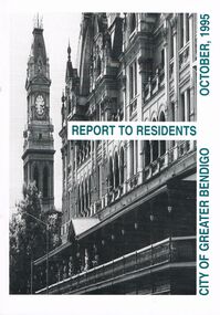
Book - BOOKLET: ''REPORT TO RESIDENTS CITY OF GREATER BENDIGO, OCTOBER 1995''
Front cover is a photo of The Shamrock Hotel. 52 paged booklet - ''Report to Residents - City of Greater Bendigo, October 1995''. Table of Contents; Commissioners; Chief Executive Officer; Council meetings; Office location and hours; ''One Telephone Number''; Committees; Ward boundaries; Elections; Customer services; Rural services; Economic development; Bendigo Tourism Board; Bendigo Trust; Events Bendigo; Capital works 1995/96; Major projects; Discovery; Bendigo Regional Arts Centre; local laws; Fire prevention; Aged and disability services; Children and family services; Environmental health; Recreation and leisure; Parks and gardens; Planning and building; Waste management; Library services; Bendigo Leisureland; Rates; Budget for 1995/96; Index. Contains some photographs and map of proposed 7 internal Wards for the City of Greater Bendigo.Richard Cambridge Printers Bendigo.bendigo, council, report, maxine crouch, maurie sharkey, perer ross-edwards, peter seamer, hadley sides, richard morriss, bernard smith, annie galvin child care centre, bendigo regional art centre, rosalind park, budget 1995/96. bendigo health care services. -
Federation University Historical Collection
Photograph - Black and White, Former Ballarat Library, c1960
First known development on this site was the establishment of the Government Camp from the early 1850s. It was established to accommodate officials, troopers and police who were needed to administer the goldfields. Some permanent buildings were constructed. Lack of materials and bad weather prolonged the building of more permanent buildings and most men were still living in tents. Area was known as Camp Reserve. In 1864 a subdivision map shows the reserve be used for Public Buildings. Library applied for land on corner of Sturt and Camp Streets in 1878. 1880s plans show section of the reserve be used for a Free Library and Reading Room. Lease was granted and the old mining boardroom was initially used. Land for additional building to house a Museum and Art Gallery sought and agreement reached in 1882-3. Compensation paid to owners and library granted the land. Plans for a new library building with tower and lantern roof abandoned due to lack of funds. It wasn't until 1895 that a solution to funding was found and the library was able to begin constructing the complex of buildings on the Free Library Reserve. A number of changes have occurred since 1910s - the Classical Revival facade replaced with an angled facade in a stripped Classical style with Art Deco features and high parapet. Building is now part of Federation UniversityPhotograph of former library. Shows a two-storey rendered brick building in a Classical style. Some Art Deco features. Central pair of double windows with single window either side. High parapet above.government camp, goldfields, camp reserve, free library, reading room, sturt street, camp street, museum, art gallery, troopers, police, barracks, camp street