Showing 4988 items matching " dandenong road"
-
 Marysville & District Historical Society
Document (Item) - Collection of photographs with notations, Unknown
A collection of photographs and notes regarding the family and home of Wykeham Lindley Perry who grew near Marysville in Victoria.A collection of photographs and notes regarding the family and home of Wykeham Lindley Perry who grew near Marysville in Victoria. Three generations of Perry's contributed to Marysville. Amongst them is Marysville's only dentist, a host and hostess of Kerami Guest House, a farmer on the Buxton road and a well-known artist, Wykeham Lindley Perry.perry family, wykeham lindley perry, kerami guest house -
 Glen Eira Historical Society
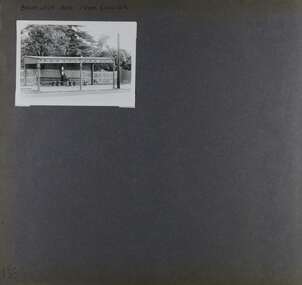
Album - Album page, Balaclava Road Tram Shelter, Circa 1972
... at the junction of Dandenong Road and Hawthorn Road, Caulfield ...This photograph is part of the Caulfield Historical Album 1972. This album was created in approximately 1972 as part of a project by the Caulfield Historical Society to assist in identifying buildings worthy of preservation. The album is related to a Survey the Caulfield Historical Society developed in collaboration with the National Trust of Australia (Victoria) and Caulfield City Council to identify historic buildings within the City of Caulfield that warranted the protection of a National Trust Classification. Principal photographer thought to be Trevor Hart, member of Caulfield Historical Society. Most photographs were taken between 1966-1972 with a small number of photographs being older and from unknown sources. All photographs are black and white except where stated, with 386 photographs over 198 pages. From Victorian Heritage Database citation H0174 TRAM VERANDAH SHELTER CORNER BALACLAVA AND ORRONG ROADS CAULFIELD NORTH - Vic Heritage Register https://vhd.heritagecouncil.vic.gov.au/places/2721 (as at 28/10/2020) The waiting shelter at the corner of Balaclava Road and Orrong Road, Caulfield was constructed in 1916/17 for the Prahran and Malvern Tramways Trust and is one of only three remaining tram shelters in Melbourne designed in the form of a verandah. The shelter has a corrugated iron roof fixed to an angle iron roof frame. The roof, which extends in the form of a skillion over the pavement, is supported on three squared, chamfered timber posts at the rear and three cast iron reeded columns with round bases and Corinthian capitals at the front. (The columns are hollow and function as downpipes, with rainwater discharging from the verandah roof, through the columns and under the ground). The shelter has a rinceau pattern frieze along the road frontage with centrally placed shield motif (which does not contain a coat of arms). The side and rear panels are lined with ripple iron and the upper panel at the rear is lattice work. The shelter has two timber slatted bench seats.From Victorian Heritage Database citation for H0174 TRAM VERANDAH SHELTER CORNER BALACLAVA AND ORRONG ROADS CAULFIELD NORTH - Vic Heritage Register https://vhd.heritagecouncil.vic.gov.au/places/2721 (as at 28/10/2020) How is it significant? The waiting shelter at the corner of Balaclava Road and Orrong Road, Caulfield is of historical and architectural significance to the State of Victoria. Why is it significant? The waiting shelter is of historical significance for its association with the development of the suburban (electric) tram network which assisted the expansion of Melbourne as a suburban metropolis. It is also of historical significance for its connection with the Prahran & Malvern Tramways Trust. The Prahran & Malvern Tramways Trust (1907-1920) was the first municipal electric tramway in Melbourne, becoming the largest and most successful of all the municipal tramway trusts. Its services played a key role in facilitating suburban expansion and the development of the southern and eastern suburbs. The growth of tramways was one of the greatest municipal developments in Victoria during the first decade of the twentieth century. The waiting shelter is an important remnant of this period of Melbourne's transport history and a tangible reminder of the Prahran & Malvern Tramways Trust. The shelter indicates the extent of the Prahran & Malvern tram network. The waiting shelter at corner of Balaclava Road and Orrong Road, Caulfield is one of only three remaining tram shelters in Melbourne designed in the form of a verandah. The waiting shelter is of architectural significance for the distinctive design and construction which is unique to the Prahran & Malvern Tramway Trust tram network. The shelter was designed by notable Melbourne architect Leonard J. Flannagan (1864-1946). Flannagan was responsible for a number of buildings for the Prahran and Malvern Tramways Trust including the early waiting shelter at the junction of Dandenong Road and Hawthorn Road, Caulfield, and sections of the tram depot at Malvern, and also designed a depot for the Hawthorn Tramways Trust. The waiting shelter, a conservative design influenced by Victorian architecture, is based on the Melbourne City Council late 19th century standard cast iron verandah. It is of significance as an intact example of the cast iron type shelter and for its detail, including Corinthian columns and a 'rinceau' pattern cast-iron frieze. The shelter is largely in keeping with the original design and retains its integrity. The cast iron waiting shelter is also of significance as an unusual example of early twentieth century street architecture. Page 155 of Photograph Album with one landscape photograph of a tram shelter on Balaclava Road.Handwritten: BALACLAVA ROAD TRAM SHELTER [top] / 155 [bottom left]trevor hart, verandah, garden, grimwade house, grimwade, orrong road, balaclava road, melbourne grammar, melbourne grammar junior school, mgs, m.g.s, school, tram shelter, waiting shelter, prahran & malvern tramway trust, leonard j. flannagan, cast iron verandah, cast iron type shelter, corinthian columns, 'rinceau' pattern cast-iron frieze, rinceau, cast iron frieze, victorian style, caulfield north, leonard flanagan, cast iron work, prahran and malvern tramways trust, trams -
Glen Eira Historical Society
Ephemera - Restaurants-Glen Eira
This file contains one item: 1/A pamphlet for Mandarin Court Restaurant, 557 Centre Road Bentleigh, and its sister restaurant in Dandenong, both owned by Michael and David Chew. The pamphlet contains the history of Mandarin Court Restaurants, maps of its locations, opening hours, and its takeaway menu. A special offer is included stamped as valid until 15/08/1987.mandarin court restaurant, chew michael, chew david, bentleigh coppins reception, centre road, bentleigh, restaurants -
 Kinglake Historical Society
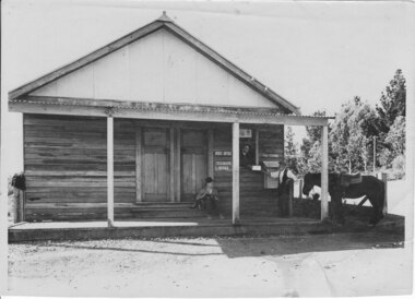
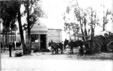
Pheasant Creek Post Office, Pheasant Creek Post Office and General Store
PhotographEarly photo of general store and post office at Pheasant Creek, includes store owner handing mail to man with horse, with other man sitting on stepphotograph taken c. 1937post office, store, pheasant creek -
 Kinglake Historical Society
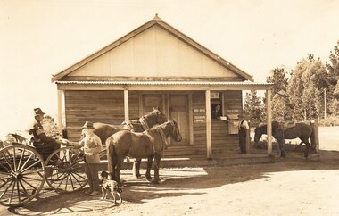
Pheasant Creek Post Office, Pheasant Creek General Store and Post Office, c.1935
Pheasant Creek General Store and Post OfficeEarly photograph showing store and post office with owner passing mail to man with horse, while a man on dray talks to man with a dog.Photograph of Pheasant Creek General Store and Post Office taken c.1935post office, store, pheasant creek -
 Kinglake Historical Society
Kinglake West township
Kinglake West corner with post office (formerly Tommys Hut) and Carman's garage on left. In the days of dirt roads.Early photograph of intersectionPhotograph of Kinglake West corner with the post office on the right and Carman's shop and garage on the left.post office, kinglake west, tommys hut, carman -
 Kinglake Historical Society
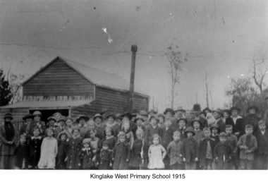
Kinglake West Primary School
Photograph of original Kinglake West Primary (State) School building with children and families. School built in 1896 by the pioneering families as Education Department would not build a school. Built on land selected by the Snell family.Only known photograph of the original school buildingPhotograph of original Kinglake West Primary School building education, school, pioneers, kinglake west -
 Kinglake Historical Society
Kinglake Post Office
Donkey team with wagon at Kinglake Post OfficePhotograph of Donkey team and wagon at Kinglake Post Office -
 Kinglake Historical Society
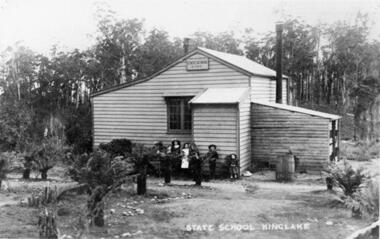
Kinglake State School
kinglake, state, school, primary, buildingPhotograph of KInglake State School original building with teachers residence attached, opened in October 1879 and burnt down in February 1927 -
 Kinglake Historical Society
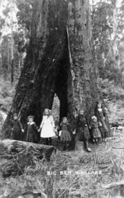
Big Ben
Big Ben, tree, Kinglake photograph of Big Ben, Kinglake -
 Kinglake Historical Society
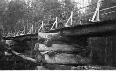
Log Bridge Kinglake
post card depicting horse and cart crossing log bridge at Kinglakeearly post card of Kinglake area including bridge and transportpost card of log bridge Kinglakekinglake, post card, log bridge, horse cart -
 Ringwood and District Historical Society
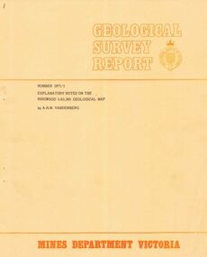
Booklet - Geological Survey Report, Explanatory Notes on Ringwood, Victoria by A.H.M. Vandenberg, 1971
Geological description of the eastern and southeastern suburbs of Melbourne, Dandenong Ranges, Harkaway Hills and the Silvan and Macclesfield districts. -
 Ringwood and District Historical Society
Map - State Aerial Survey, Dandenong Ranges Area, Parishes of Warrandyte and Ringwood - 1956
Map of central and southern areas of Ringwood and part of Ringwood East and Heathmont compiled by Dept of Lands and Survey, July 1956, from aerial photographs and Cadastral Survey information. Subsequent hand-drawn addition of streets showing layout of "Township of Ballyduffy Estate 1858-60", an earlier proposed subdivision that did not eventuate. (See attached 5009b Ballyshanassy_ Melbourne’s lost suburb.pdf for Ballyduffy historical naming relevance). Ballyduffy Estate streets include City Road, West Prussia Road, Duffy Street, Ireland Street, Evans Street, Victoria Street, Regina Street, Short Road, Prussia Road, Duffy Street East, Ireland Street East, Evans Street East, Chapman Street. Misc Topo 93 Sheet 22, Ringwood A4B2. Scale: 4 chains to 1 inch. Contour interval 20 feet. -
 Ringwood and District Historical Society
Map - State Aerial Survey, Dandenong Ranges Area, Parts of Parishes of Nunawading, Warrandyte and Ringwood - 1956
Map of Ringwood North and parts of Mitcham, Donvale, Park Orchards and Ringwood East compiled by Dept of Lands and Survey, July 1956, from aerial photographs and Cadastral Survey information. Sheet 1, Ringwood A2D or 849 A2D Zone 7. Scale: 4 chains to 1 inch. Contour interval 20 feet. -
 Ringwood and District Historical Society
Map - State Aerial Survey, Dandenong Ranges Area Sheet 7, Parishes of Warrandyte, Scoresby, Ringwood and Nunawading - 1956
Map of central and southern areas of Ringwood and part of Ringwood East and Heathmont compiled by Dept of Lands and Survey, July 1956, from aerial photographs and Cadastral Survey information. Subsequent coloured hand-drawn additions showing layout of a number of post-NSW Separation era proposed subdivisions that did not eventuate, including Village of Studley Estate, Township of East Kew Estate, Township of Ballyduffy Estate, Township of New Flemington Estate, Township of East Hawthorne Estate. Ringwood A4B2, 849 A4B Zone 7. Scale: 10 chains to 1 inch. Contour interval 20 feet. -
 Ringwood and District Historical Society
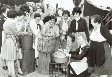
Photograph, Ida Oke and all at Dandenong Scouting Jamboree in 1965
Scanned on 30th January, 2008 from Ida Oke's albums. Ida lives in East Ringwood and also contributed to the East Ringwood Recollections book. Wife of Bob (Robert William) Oke. Both Ida and Bob were heavily involved in the Scout movement, as were Bob's parents - Corrie and Ruby (Guides) Oke, who both lived in Old Lilydale Road, East Ringwood. -
 City of Moorabbin Historical Society (Operating the Box Cottage Museum)
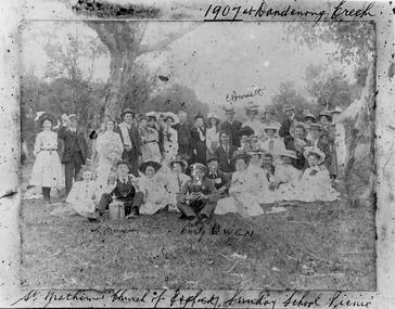
Photograph - St Matthew's Church of England Sunday School Picnic 1907, 1907
The Anglican Cheltenham parish was created in 1865 by excising a portion of the parish of St Andrews Brighton. A small brick church was completed in 1867 to serve a rural community stretching from Brighton South (Moorabbin) to Mordialloc. 1867 St Matthew's Church of England was erected in Cheltenham beside the Nepean Highway near Charman Road. The early settlers established a tennis club, cricket team and social groups. A typical social event was the annual Sunday School Picnic held in 1907 at Dandenong Creek.Young members are mentioned Curly Owen,C,Burnett,A Manett St Matthew's Church of England Cheltenham was erected in 1867 and was integral to the spiritual well being and social life of the early settlers.Black & White photograph of the St Matthew's Church of England Sunday School Picnic 1907Handwritten Curly Owen, C, Burnett, A Manett st. matthew's church of england cheltenham, sunday school picnics, anglican church, st andrew's church brighton, owen curly, burnett c . manett a, horse drawn carts, toll gates brighton, motor cars 1900, steam engines, early settlers, bentleigh, parish of moorabbin, city of moorabbin, county of bourke, moorabbin roads board, shire of moorabbin, henry dendy's special survey 1841, were j.b., bent thomas, o'shannassy john, king richard, charman stephen, highett william, ormond francis, maynard dennis, market gardeners, vineyards, orchards -
 City of Moorabbin Historical Society (Operating the Box Cottage Museum)
Photographs, 7 x B&W Circa 1918 Cheltenham Methodist Youth Group, Circa 1918 Photos of Cheltenham Methodist Youth Group, 1918
Circa 1918: Various Photos of the Cheltenham Methodist Youth Group. Row 1 and 2: "At Flinders". Row 3: 1st Left, "Holidaying at Cockatoo". in 1852 Stephen Charman, who had arrived in Melbourne 1842 aged 21 years as one of Henry Dendy's emigrants, purchased 160 acres in Spring Grove ( now Cheltenham). Stephen and his family lived in a wattle and daub hut and worked hard to establish a market garden, poultry and pig farm. The first Methodist Church Services were held at their home. In 1855 Stephen gave 1 acre of his land on Balcombe Road to the Methodist Church for a School, Burial ground and a Chapel which was built in 1857.The Methodist Church, Balcombe Road was the 2nd religious building to be erected in Spring Grove now known as Cheltenham c 18577 small black and white photographs of the Cheltenham Methodist Youth Group at Flinders, Cockatoo and unkown locations, c 1918 . First 3 photos are of male cyclists on a trip to Flinders, Victoria. Photo 4 shows 6 ladies and a man on holiday at Cockatoo in the Dandenong Ranges ,Victoria . Photos 5 to 7 show men, women and children in bushland surroundings of unrecorded locations.Photo 1 - 3 on back : Flinders 1918 Photo 4 left on back : Holiday at Cockatoo right on back : Whitehead Photo 5-7 nilcheltenham, cheltenham methodist youth group, 1914, 1918, charman stephen, gettens mary, spring grove, methodist church, charman road, balcombe road, dendy henry, henry dendy's special survey 1841, youth groups, social groups, market gardners, early settlers, pioneers, dairy farmers, poultry farmers, pig farmers,moorabbin, brighton, -
 City of Moorabbin Historical Society (Operating the Box Cottage Museum)
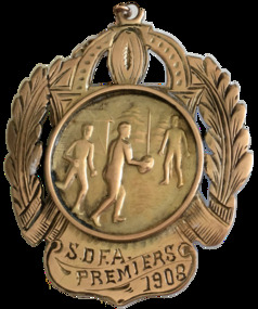
Badge - S.D.F.A. Premiers 1908 (Sandringham District Football Association), c 1908
Sandringham and Ellindale (now McKinnon Football Club) played off for the district premiership on the Friendly Societies Ground, Melbourne on 26 September 1908. Ellindale won the game but had to wait to see if they won a protest against Dandenong before they could claim that they had won the premiership. In the local paper, the Brighton Southern Cross on Saturday 10 October 190, it was reported that Ellindale were the premiers of the season. This medal was awarded to W. Kennedy, who was a forward for Ellindale.A Premiership Medal presented in 1908 to W.Kennedy an early settler in Moorabbin Shire The Medal is made from 9ct gold and engraved with a sheath on the edges and a picture of men playing football in the centre,Side one - S.D.F.A. Premiers - 1908 Side two - Ellindale F.C. W. Kennedy Forwardsandringham football club, ellindale football club, football final 1908, w. kennedy, mckinnon football club, sandrigham district football association, moorabbin shire, early settlers, market gardeners -
 City of Moorabbin Historical Society (Operating the Box Cottage Museum)
Container - Griffiths Tea Canister, 1900-1940
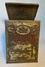
In 1873 James Griffiths migrated to Melbourne in order to start a tea Business. James lived in the Dandenongs at The Basin where he experimented with growing tea. Griffiths made tin canisters in the 2lbs size for their tea with common kitchen consumables listed on the front . The tins, when emptied, became useful kitchen canisters and helped promote the brand. Example of the names include Flour, Rice, Sugar, Sago, Candied Peel, Tapioca, Spices, Starch, Biscuits, Currants, Barley, String and of course Tea .Food storage rectangular tin, with a hinged lid. The outside is printed in cream and red with the name 'Griffith's Teas' and the word 'SAGO'. The text is set against a cream panel which is bordered with a decorative border of Australian native flora. The whole is set against a dark green background.On each other side of the tin is a different native Australian flower. The lid is impressed with a flannel flower.Printed on the front 'SAGO', also printed on the front and repeated on the top 'USE / GRIFFITHS' Teas / SYDNEY / MELBOURNE. ADELAIDE. BRISBANE'. On the front is the image of a train signal with the words 'SIGNAL / TRADE MARK'tea, james griffiths, canisters, city of moorabbin, cheltenham, melbourne, moorabbin, grocery stores, kitchen equipment -
 City of Moorabbin Historical Society (Operating the Box Cottage Museum)
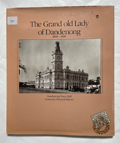
Book, Dandenong and District Historical Society, The Grand old lady of Dandenong, 1890-1990, 1990
... Cottage Museum) Joyce Park Jasper Road Ormond melbourne Dandenong ...64 p. : chiefly ill. ; Includes index.dandenong, dandenong town hall -
 City of Moorabbin Historical Society (Operating the Box Cottage Museum)
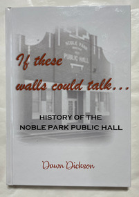
Book, Dickson, Dawn, If these walls could talk : History of the Noble Park Public Hall
The story and stories of Noble Park Public Hall.The story and stories of Noble Park Public Hall.non-fictionThe story and stories of Noble Park Public Hall.noble park, dandenong, public hall -
 Cockatoo History & Heritage Group
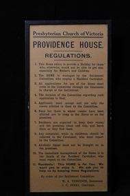
Regulations, Providence House Regulations, Cockatoo Victoria
The Presbyterian Church owned three lots of land bounded by Pakenham Road and the northern side of Dorchester Road, between 1927 and 1964. Providence House opened in 1927 as a peaceful country rest home for “tired mothers” from the inner suburbs, and their children. It was also used, at different times, for kindergarten groups and in 1955 for a girls Bible Class for Easter “studies, fun and fellowship.”Cockatoo had several guest houses which took paying guests. Providence House did not charge fees, but is the best-documented of the large houses which provided accommodation.Framed regulations for the Presbyterian Church of Victoria's Providence House in Cockatoo.providence house, cockatoo victoria, presbyterian church, regulations, -
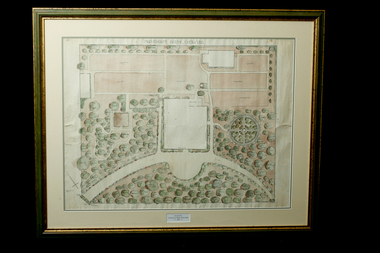 Cockatoo History & Heritage Group
Landscape Plan, Providence House Cockatoo, 1930's
The Presbyterian Church owned three lots of land bounded by Pakenham Road and the northern side of Dorchester Road, between 1927 and 1964. Providence House opened in 1927 as a peaceful country rest home for “tired mothers” from the inner suburbs, and their children. It was also used, at different times, for kindergarten groups and in 1955 for a girls Bible Class for Easter “studies, fun and fellowship.”Cockatoo had several guest houses which took paying guests. Providence House did not charge fees, but is the best-documented of the large houses which provided accommodation.Framed landscape design plan under glass, with detailed plant listings. Original watercolourDonated by Victoria & Digby Newcombe 2003presbyterian church, rest home, landscape plan, garden design, cockatoo victoria, providence house, black n.c, -
 Koo Wee Rup Swamp Historical Society
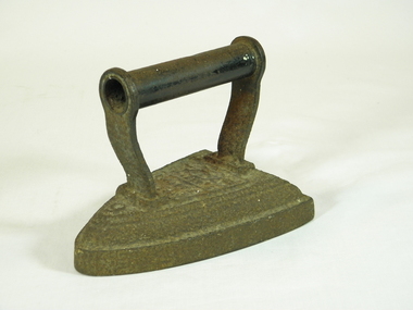
Iron, circa 1900
Cast iron flat iron, with handle.Markings on top of iron - the number 6, Silversters patent and Salter and scroll work.irons, flat irons -
 Koo Wee Rup Swamp Historical Society
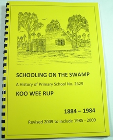
Book, Koo Wee Rup Primary School, Schooling On The Swamp, November 2009
History of Koo Wee Rup Primary School. Includes information about other schools (past and present) in Koo Wee Rup Swamp area : Bayles, Caldermeade, Cardinia, Catani, Cora Lynn, Dalmore East, Iona, Island Road, Koo Wee Rup North, Koo Wee Rup South, Heath Hill, Lang Lang, Protectors Plains, Modella, Tooradin, Tooradin North, Yannathan, Yannathan South. School Centenary History updated and expanded for 125 anniversary of Koo Wee Rup Primary School (1884-2009) Includes brief account of geography of Koo Wee Rup Swamp, and local indigenous people.A history of Primary School No. 2629, Koo Wee Rup : 1884 - 2009 (Revised for school 125th. anniversary - November 2009) compiled by Don Jewell. 62 pages, A4, plastic spring binding.koo wee rup primary school, centenary history -
 Monbulk RSL Sub Branch
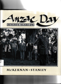
Book, Peter Stanley et al, Anzac Day seventy years on, 1986
A pictorial record of the commemoration of ANZAC day in 1985Ill, p.168.non-fictionA pictorial record of the commemoration of ANZAC day in 1985australia - social life and customs, anzac day - pictorial works -
 Monbulk RSL Sub Branch
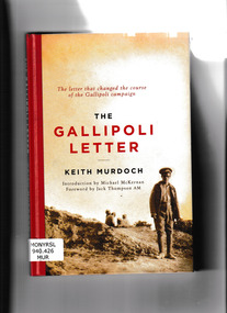
Book, Keith Murdoch, The Gallipoli letter, 2020
The Gallipoli letter is an 8000 word private report which was written by Keith Arthur Murdoch after he visited the Gallipoli peninsula in September 1915. It describes the organisation, and conditions of the Gallipoli campaign. It was sent to Andrew Fisher (Australian Prime Minister) and Henry Herbert Asquith (British Prime Minister). This letter changed the course of the Gallipoli campaign.Ill (facsims), p.98.non-fictionThe Gallipoli letter is an 8000 word private report which was written by Keith Arthur Murdoch after he visited the Gallipoli peninsula in September 1915. It describes the organisation, and conditions of the Gallipoli campaign. It was sent to Andrew Fisher (Australian Prime Minister) and Henry Herbert Asquith (British Prime Minister). This letter changed the course of the Gallipoli campaign.world war 1914-1918 - campaigns gallipoli, war correspondents - australia, keith murdoch -
 Monbulk RSL Sub Branch
Book, Richard Reid, Gallipoli, 2010
A pictorial history of the Australian experience in the Gallipoli campaignIll, maps, p.168non-fictionA pictorial history of the Australian experience in the Gallipoli campaignworld war 1914-1918 - campaigns - gallipoli, gallipoli campaign - pictorial works -
 Monbulk RSL Sub Branch
Book, Richard Reid, Gallipoli 1915, 2002
Pictorial history of the Australian participation in the Gallipoli campaignBibliography, iIll (col), p.154.non-fictionPictorial history of the Australian participation in the Gallipoli campaignworld war 1914-1918 - campaigns - gallipoli, gallipoli campaign - pictorial works