Showing 25160 items matching "home-built"
-
 Kew Historical Society Inc
Archive (Sub-series) - Subject File, 'Fairview', 34 Wrixon Street (Kew), 1979
Various partiesReference, Research, InformationSecondary Values (KHS Imposed Order)Subject file containing information about Fairview (built 1924 for F.F. Robinson, proprietor of Yarra Falls Mills). The house replaced an earlier single-storey brick house, also called Fairview. A comprehensive report prepared by Alan Willingham in 2006 found that there was no evidence that the architect Desbrowe-Annear incorporated parts of the original building in the new construction. The work by Willingham is a ‘Cultural and Architectural History and Assessment of the Cultural Heritage Significance’ of the building, prepared for Carey Grammar School. The Willingham report was donated by Sr Ruth Anderson.kew (vic) - history, fairview - 34 wrixon street - kew (vic), cluny house - 34 wrixon street - kew (vic), f.f. robinson, alan willingham, harold desbrowe-annearkew (vic) - history, fairview - 34 wrixon street - kew (vic), cluny house - 34 wrixon street - kew (vic), f.f. robinson, alan willingham, harold desbrowe-annear -
 Kew Historical Society Inc
Map, MMBW, MMBW Plan No.39 Kew & Heidelberg, 1900-1910
The Melbourne and Metropolitan Board of Works (MMBW) was established by an act of the Victorian Parliament in 1890 to prepare for and to implement a sewerage and water reticulation system across what was then inner Melbourne, its surrounding and middle distance suburbs, including Kew. The MMBW was disbanded in 1991.The map collection of the Kew Historical Society has at its core the historic maps assembled and originally stored in the City Engineer's Department of the City of Kew. These include maps in a number of scales. The vast majority of maps were produced by the MMBW in the first two decades of the twentieth century, and are solid working maps, backed by linen for durability. These maps are historically significant to Kew, the City of Boroondara and to the history of the development of state utilities in Victoria. A number of the Kew maps have additional details added by former municipal officers, including the levels reached by various floods. As these were working documents, information was added to them long after the period of their initial production and distribution.Early map of part of the Borough of Kew, created in the first decade of the twentieth century, at a scale 160 ft to 1 inch. The map covers what was then the north western section of Kew, bordered on its north by Wills Street and the Kew Lunatic Asylum, in the west by the River Yarra [and the later added Yarra Boulevard] , by Princess Street in the East and Holroyd Street in the south. The map shows the extent of urban development by that time, prominent institutions and the outlines of built structures in the municipality. Contour lines were added in ink to the map at a later stage.MELBOURNE AND METROPOLITAN BOARD OF WORKS / PLAN NO. 39 / KEW & HEIDELBERGmelbourne & metropolitan board of works, mmbw maps, mmbw plans, borough of kew, cartography -
 Kew Historical Society Inc
Map, MMBW, MMBW Plan No.67 Kew, 1900-1910
The Melbourne and Metropolitan Board of Works (MMBW) was established by an act of the Victorian Parliament in 1890 to prepare for and to implement a sewerage and water reticulation system across what was then inner Melbourne, its surrounding and middle distance suburbs, including Kew. The MMBW was disbanded in 1991.The map collection of the Kew Historical Society has at its core the historic maps assembled and originally stored in the City Engineer's Department of the City of Kew. These include maps in a number of scales. The vast majority of maps were produced by the MMBW in the first two decades of the twentieth century, and are solid working maps, backed by linen for durability. These maps are historically significant to Kew, the City of Boroondara and to the history of the development of state utilities in Victoria. A number of the Kew maps have additional details added by former municipal officers, including the levels reached by various floods. As these were working documents, information was added to them long after the period of their initial production and distribution.Early map of part of the Borough of Kew, created in the first decade of the twentieth century, at a scale 160 ft to 1 inch. The map covers what was then the north central part of Kew, bordered on its north by the Outer Circle Railway Spruzen and Beresford Avenues, in the west by Princess Street, in the south by High Street, and in the east by (about) Belford Road. The map shows the extent of urban development by that time, prominent institutions and the outlines of built structures in the municipality. Contour lines were added in ink to the map at a later stage.MELBOURNE AND METROPOLITAN BOARD OF WORKS / PLAN NO. 67 / KEW melbourne & metropolitan board of works, mmbw maps, mmbw plans, borough of kew, cartography -
 Kew Historical Society Inc
Map, MMBW, MMBW Plan No.68 Kew, 1900-1910
The Melbourne and Metropolitan Board of Works (MMBW) was established by an act of the Victorian Parliament in 1890 to prepare for and to implement a sewerage and water reticulation system across what was then inner Melbourne, its surrounding and middle distance suburbs, including Kew. The MMBW was disbanded in 1991.The map collection of the Kew Historical Society has at its core the historic maps assembled and originally stored in the City Engineer's Department of the City of Kew. These include maps in a number of scales. The vast majority of maps were produced by the MMBW in the first two decades of the twentieth century, and are solid working maps, backed by linen for durability. These maps are historically significant to Kew, the City of Boroondara and to the history of the development of state utilities in Victoria. A number of the Kew maps have additional details added by former municipal officers, including the levels reached by various floods. As these were working documents, information was added to them long after the period of their initial production and distribution.Early map of part of the Borough of Kew, created in the first decade of the twentieth century, at a scale 160 ft to 1 inch. The map covers what was then the north central part of Kew, bordered in the north by Oak Avenue, in the west by the Yarra River and Connor's Creek, in the south by Beresford and Carnegie Avenues, and in the east by Glass's Creek and Burke Road. The map shows the extent of urban development by that time, prominent institutions and the outlines of built structures in the municipality. Contour lines and the levels of historic floods were added in ink to the map at a later stage.MELBOURNE AND METROPOLITAN BOARD OF WORKS / PLAN NO. 68 / KEW melbourne & metropolitan board of works, mmbw maps, mmbw plans, borough of kew, cartography -
Maldon Vintage Machinery Museum Inc
Invalid Car
Battery powered invalid tricycle. Black body-work, wire spoked wheels, 2 small headlights. Appears to be built to accommodate a reclining figure. Contains 2 crimson corduroy cushions, one solid seat cushion filled with Dunlopillo, the other a rectangular back-rest cushion filled with latex foam rubber. Original seat cushion had sage green top with blue/white striped mattress ticking sides & back. Original back support cushion had a cloth label - see below. On an aluminium plate on top of the electric motor :- "Chassis No. 2067, Type EC2, 24-36 volts / RPM 2700 Serial No. 2161". On back cushion: "TEX Foam / Yours for restful sleep / Contents / New Latex Foam / Made by TEXFOAM PTY LTD. Mordialloc. Victoria"transport ..... motor ...... invalid -
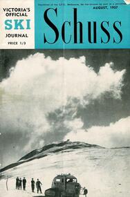 Falls Creek Historical Society
Journal - Schuss Vol. 23. No. 6 August 1957
Schuss was advertised as Victoria’s Official Ski Journal It was issued monthly from 1935 to 1961 except during the war when summer issues covered two months. This continued after the war, but it averaged 10 issues annually over its 25 year life. Schuss was published by the Ski Club of Victoria which had a membership of 38 Ski Clubs and demanded to be recognised as the prime authority on skiing in the state. The other 30 ski clubs with 85% of the members disagreed and the politics of skiing became heated. These clubs formed the Federation of Victorian Ski Clubs with their own journal, Ski Horizon. With the establishment of the Victorian Ski Association, Ski-Horizon published its last issue in Nov - Dec. 1955 and the role of the official journal was fully taken over by “Schuss”. This item is significant because it contains stories, images and information documenting the development of the ski facilities at Falls Creek.The journal features stories and events chronicling developments in Victoria and internationally. In this issue:- Front Cover features a photo of John Hilton Wood's Snow Cat below the summit of Mt Buller taken by Eric Burt. Page 211 - Stop Press Items including recent Ski event results Page 217 features a detailed report on Australia's first Ski Chair-Lift at Falls Creek, Victoria which began operation on Saturday 27th July. It was built by Bob Hymans to the design of Dr V Hajek.schuss journal, the ski club of victoria, bob hymans -
 Lakes Entrance Historical Society
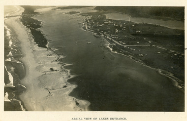
Photograph - Lakes Entrance, 1923c
Two copies 16.5 x 25.5 very darkBlack and white photograph showing early aerial view of township of Lakes Entrance, photo shows highway going along Myer Street and along Roadknight Street, no shops in Myer Street appears to be no foot bridge, therefore taken prior to 1937, sparce vegetation on foreground dunes, four barriers built on dunes to stop erosion through sand, two masted sailing boat in lake. Bullock Island in distance appears very small, Snake Island of Rigby Island in centre distance. Lakes Entrance VictoriaAerial View of Lakes Entrancewaterways, coast, aerial photograph, islands, township -
 Bendigo Historical Society Inc.
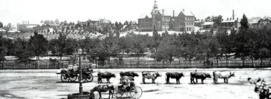
Negative - TOM PATULLO COLLECTION: A COUNTRY TOWN
Negative print. Rosalind Park (Camp Reserve), Bendigo looking over Park Road, the Bendigo Creek, Camp Hill State School, with the Bendigo Masonic Hall Left and the Government Camp on the top of the Hill; near where the present day lookout tower stands; to the left of the state school. The Consolidated High School is on the extreme right hand side. The police barracks are between the two schools. The original consolidated school building has been built around and is incorporated into the current Bendigo Senior Secondary School buildings.bendigo, sandhurst, tom patullo collection, bullock wagon, camp reserve bendigo, rosaling park bendigo, camp hill school, bendigo consolidated high school -
 Bendigo Historical Society Inc.
Photograph - SPECIMEN COTTAGE HARGREAVES STREET, BENDIGO
3 photos: Colour photo of Specimen Cottage, taken from footpath looking northwards. Image shows student on LH side walking on footpath, trees in leaf either side of building. Cottage is built from sandstone, wooden balcony. Colour photo of the conservatory and gardens taken from an elevated position. Colour photo Golden Dragon Museum. All Photos taken in April 2001. Piece of paper in the pocket identifies Gordon & Wendy Willa, of deakin St Lockington 3563, and email: gordon&[email protected], buildings, specimen cottage, sandhurst, bendigo, specimen cottage, hargreaves street, building, brierley -
 Bendigo Historical Society Inc.
Newspaper - JENNY FOLEY COLLECTION: TEACHERS
BHS CollectionBendigo Advertiser ''The way we were'' from Friday, November 26, 2004. Teachers: the original Kangaroo Flat common school opened in July,1870, with 130 pupils. This site later became known as the ''Annexe''. The present site of the Kangaroo Flat primary school began operation in February 1953, in the 'Bristol' prefabricated classrooms. These classrooms are still in use. A new $5.2 million school is being built in Olympic Parade and will be completed about April next year. The above staff photo was taken in 1975.newspaper, bendigo advertiser, the way we were -
Melbourne Tram Museum
Newspaper, The Sun, 10 new orange tramway buses, 5/02/1975 12:00:00 AM
Newspaper clipping - untitled The Sun, Wednesday, Feb 5, 1975 Photo and text of new tramways bus 10 new orange tramway buses have begun service in the metropolitan area, 20 more being assembled in Sydney and should be in operation later in 1975. Built in England by Leyland and cost $32,000 each. Bus driver Bruce McRae of Thornbury said easier to handle, very manoeuvrable in heavy traffic and have very acute turning circle. Ride is smoother and driver’s seat and passengers’ seats are more comfortable.trams, tramways, thornbury, buses, leyland -
 Melbourne Tram Museum
Document - Report, Melbourne & Metropolitan Tramways Board (MMTB), "Rolling Stock Department - Annual Report", Jul. 1940
Report - six foolscap sheets stapled in the top left hand corner enclosed by folder protective corner, titled "Rolling Stock Department - Annual Report for the year ending 30 June 1940". Gives details of the trams maintained and built, the workshops, running sheds, availability, buses, new buses, improvements to the rolling stock, defence work, work for other departments, foundry, laboratory, drawing office cable system and staffing. Last sheet details various classes available for service and those under construction.trams, tramways, workshops, staff, new trams, world war 2, buses -
 Melbourne Tram Museum
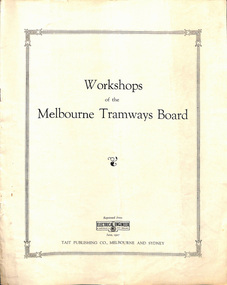
Document - Report, Electrical Engineer, Melbourne and Metropolitan Tramways Board, "Workshops of the Melbourne Tramways Board", 1927 and 1928
Report or publication - reprint of an article from the "Electrical Engineer" - 15/6/`1927 - "Workshop of the Melbourne Tramways Board" - includes a detail description of the new workshops, the capability, some images, diagrams includes a building and track layout, cross sections of the pits, the organisation of the shop. Inside the large page is glued a typed sheet giving the areas of the site, the various shops, costs, men employed, number of new trams built and number of cars through the workshop for maintenance and repairs - dated 9-5-1928trams, tramways, preston workshops -
 Melbourne Tram Museum
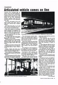
Document - Photocopy, Engineers Australia, "Articulated vehicle comes to life", "Monitor system speeds buses and trams", Mar. 1985
Photocopy of two pages of the Institute of Engineers magazine "Engineers Australia" 8/3/1985 issue containing two articles: "Articulated vehicle comes to life" - about the introduction of B class trams to Melbourne as Light Rail vehicles, built by Comeng, conversion of the Port Melbourne and St Kilda light rail lines and recent tram line extensions. "Monitor system speeds buses and trams" - about the introduction of the Metropolitan Transit Authority of the AVM - automatic vehicle monitoring system for the tram and bus fleet. Gives an outline of the system.trams, tramways, light rail, conversion, st kilda, port melbourne, b class, avm, automatic vehicle monitoring -
 Geoffrey Kaye Museum of Anaesthetic History
Machine - Geoffrey Kaye's spirometer, Dr Geoffrey Kaye
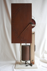
This spirometer, built by Geoffrey Kaye for demonstration purposes, features a large, rectangular panel of wood with a wooden needle and a dial numbered from 000 to 3000 in increments of 100, which would have measured a patient's lung capacity as they breathed into a tube which is no longer present. The panel is attached to a wooden frame, which also supports a red Stenco brand pulley attached to a metal canister and a counterweight. There are two taps on the bottom of the canister. There is an elongated U-shaped glass tube affixed to a wooden plank to the right of the canister, beneath the pulley.spirometer, spirometry, machine, diagnostic machine, diagnostic machinery, respiration, lung capacity, tidal lung capacity, geoffrey kaye -
 Bendigo Historical Society Inc.
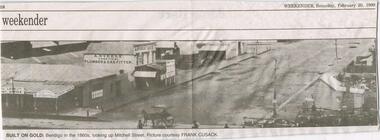
Newspaper - JENNY FOLEY COLLECTION: BUILT ON GOLD
BHS CollectionBendigo Weekender from Saturday, February 20, 1999. Built on gold: Bendigo in the 1860s, looking up Mitchell Street. Bottom left corner shows a loan office and a saddler,AQ. Steele practical Plummer And Gas Fitter, A. Steele 'AGE', rooms,Timber Yard. Middle front is horse and cart with roof. person. Right of centre, tall post with sign, building with gable roof and annex with chimney, part of another building with a fence, bottom part of another post. Picture courtesy of Frank Cusack.newspaper, bendigo, bendigo weekender -
 Bendigo Military Museum
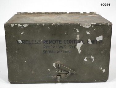
Equipment - WIRELESS REMOTE CONTROL UNIT, PMG, 1944
Heavy Cast aluminium box with hinged lid. Colour is drab olive. Each end has a belt loop. There is a semi rotating clip on the front of the lid section to hold it shut. Inside are, Morse key, 3 switches, Buzzer Assembly, 3 terminals and built in battery box. Inside the lid are the circuits for the device and operating instructions. On lid top are numbers 732 and an arrow head. On front is "Wireless Remote Control Unit A, PMG s W/S SYD. Serial No. 19055." Insie the hinge bracket is broken.Inside on battery compartment lid is:- "Wireless Remote/ Control Unit A/ PMG W/S STD/ Ser No. 19055/ 1944. signals, army, equipment, remote control unit -
 Port of Echuca
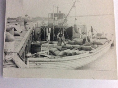
Black and white photograph, Before 1920
The P.S Clyde was built in 1884 by W.Wilson, in Echuca and was owned by the Evans Bros. It sunk in the Murrumbidgee river in 1920 and was raised and converted into a barge in 1922. The barge Excel was built as the Barge Adam in 1897. It was owned by the Permewan Wright Co. and renamed barge 'Excel' in 1909. (Ref ; Parsons, Ronald, "Ships of the Inland Rivers" This photograph must have been taken before 1920 when the P?S Clyde was still a paddle steamer.One of two black and white photographs of the P.S Clyde and the barge Excel moored to a wharf, possibly at Swan Hill. People are on the wharf and both vessels. There is a crane fitted on the Clyde loading, bags of wheat. A woman is standing in front of the wheel house. There is a man inside the wheel house. Steering mechanism appears to be attached at the back of the barge, and there also appears to be a flag flying on the back of the barge. Three men are on the barge supervising the loading process.Written on the back of the smallest photograph are the words "2nd copy in Clyde file." On the barge in the photograph is the word 'EXCEL' 'and the word 'Clyde' can be seen on the bow of the paddle steamer .p.s.clyde, excel, adam, evans bros, murrumbidgee river -
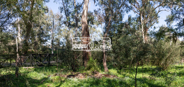
 Eltham District Historical Society Inc
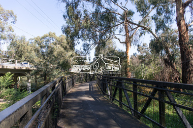
Photograph, Peter Pidgeon, Manna Gums, Main Road Bridge, Eltham South, 8 Sep. 2021
The original timber bridge over the Diamond Creek was built around 1840. It was destroyed by floodwaters in October 1923. A temporary bridge was rigged up but further damaged in April 1924. A new concrete bridge was built and opened in October 1926. The bridge decking was widened along with Main Road to Dalton Street by the Road Construction Authority in 1984., The uygraded bridge was opened in October 1984, 78 years after its original opening.These trees are not only significant for the natural environment but also present a navigational beacon back in time as the environmental landscape is developed around them.Born Digitaleltham south, main road bridge, manna gum, diamond creek trail -
 Eltham District Historical Society Inc
Photograph, Peter Pidgeon, Main Road Bridge, Eltham South, 8 Sep. 2021
The original timber bridge over the Diamond Creek was built around 1840. It was destroyed by floodwaters in October 1923. A temporary bridge was rigged up but further damaged in April 1924. A new concrete bridge was built and opened in October 1926. The bridge decking was widened along with Main Road to Dalton Street by the Road Construction Authority in 1984., The uygraded bridge was opened in October 1984, 78 years after its original opening. Born Digitaleltham south, main road bridge, diamond creek (creek) -
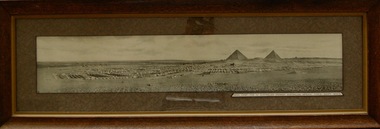 Lara RSL Sub Branch
Photograph, Mena Camp Egypt 1914-15
The Mena Camp, Egypt, was the training camp for the 1st Australian Imperial Forces(AIF) before the Landing at Gallipoli. The camp was located 16Kms from Cairo.Built around Mena House, it was a luxury hotel built next to the Pyramids of Giza (originally spelt Gizeh) supplied with its own purpose built tram-line to Cairo. The centre road up the middle of the camp was known as Artillery Road. The initial force consisted of 20,000 men.The Camp was a major training facility for the 1st Australian Imperial Force in 1014-15.Rectangular shaped glass covered picture frame showing a photo of Mena Camp-1914/15.Mena Camp-1st Australian Division. Australian Imperial Force-Egypt. 1914-15.mena camp, egypt, gallipoli, cairo, lara r.s.l. training camps, australian imperial force. -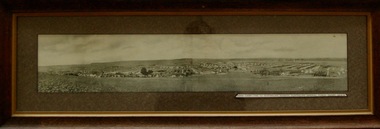
 Greensborough Historical Society
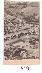
Newspaper clipping, Greensborough shopping centre 1970, 1970_
The photograph is of the centre of Greensborough in 1970, prior to the Greensborough Plaza being built. The Partington farm house, named 'Alwyn' (after Alan and Wyn Partington) can be seen north of the Railway Line. Alan and Wyn had to leave this farm in 1976 - moving to a new house - built by son Gary - at 54 Manatunga Circuit - to make way for the creation of Whatmough Park and development of the Hailes Street-The Circuit-Greensborough Plaza precinct.This is an important visual record of Greensborough before the redevelopment of the late 1970's. It also shows the Whatmough park area when it was still the Partington family farm.A black and white newspaper clipping featuring an aerial photograph.Nilgreensborough streets, greensborough, aerial photograph, 1970, partington, whatmough park, greensborough swimming pool -
 Kiewa Valley Historical Society
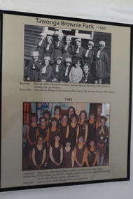
Posters - "Tawonga Remembers" x 5
The town of Tawonga is in the Kiewa Valley surrounded by farmland. It is adjacent to Mt Beauty (built in 1946) , an SECV town built for the workers on the Kiewa Hydro Electric Scheme which was being constructed from 1911-1961. Tawonga consisted of essential amenities including a store, school, butter factory, sporting facilities, post office, hall and hotel. Activities involved sport, social get togethers eg. dances, fundraising, CWA etc.The posters are a collection of historical photos, documentation and information regarding the history of the town of Tawonga, which is the centre of a faming community in the Kiewa Valley.Posters framed with thin black plastic strip, covered, by glass. Each one has a title re "Tawonga Remembeers" and includes print and photos in black and white. Beige background. 1. The History of Guiding in Tawonga; 2. Tawonga Cubs; 3. Cubs and Scouts; 4. Tawonga Brownie Pack -1960; 5. Tawonga Guide Company -1966tawonga, photos of early tawonga, kiew valley, tawonga remembers, cubs, scouts, brownies, guides -
 Kiewa Valley Historical Society
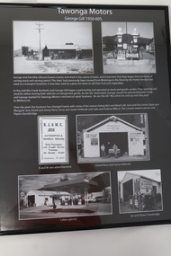
Posters - "Tawonga Remembers" x 4
The town of Tawonga is in the Kiewa Valley surrounded by farmland. It is adjacent to Mt Beauty (built in 1946), an SECV town built for the workers on the Kiewa Hydro Electric Scheme which was being constructed from 1911 to 1961. Tawonga consisted of essential amenities including a store, school, butter factory, sporting facilities, post office, hall and hotel. Activities involved sport, social get togethers eg. dances, fundraising, CWA etc.The posters are a collection of historical photos, documentation and information regarding the history of the town of Tawonga,which is the centre of a farming community in the Kiewa Valley.Poster framed with thin black plastic strip, covered, by glass. Each one has a title re "Tawonga Remembers" and includes print and phtots in black and white. Black background. 1. Tawonga SEC Depot; 2. Tawonga Service Station circa 1940s; 3. George Johnston's Taxi Service; 4. Tawonga Motors 1950-60stawonga, photos of early tawonga, kiewa valley, tawonga remembers, transport -
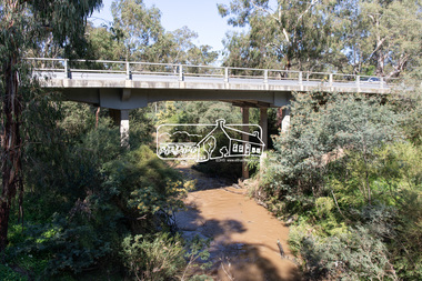
 Eltham District Historical Society Inc
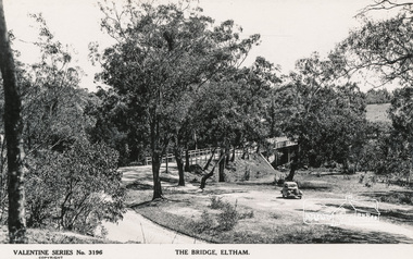
Postcard - Photograph, The Rose Stereograph Company, The Bridge, Eltham, c.1939
Looking west across the Main Road Bridge over the Diamond Creek at Eltham, c.1939. The car in the foreground, possibly the photographer's, is a Ford Model C Ten built by Ford UK between 1934 and 1937. The Model C was released in Australia in 1935. The Ford Model C Ten is a car that was built by Ford UK between 1934 and 1937. The Model C was released in Australia in 1935 https://en.wikipedia.org/wiki/Ford_Model_C_TenPostcardValentine Series No.3196diamond creek (creek), ford model c ten, main road bridge, postcard, valentine series postcard, bridge, cars, eltham, eltham south, main road, motor vehicles, rose stereograph, rose stereograph company -
 City of Moorabbin Historical Society (Operating the Box Cottage Museum)
Booklet - Souvenir History of Centre Road, Bentleigh Methodist Church Centenary Celebrations. 9 May - 17 May 1953, 1953
Methodist Church, Centre Road. The first church building on the site was built of timber in 1850. In 1865, the wooden church building was sold and a new brick church was built, this building was expanded over the years to accomodate an ever increasing congregation. In 1928 the parish opened yet another new brick church - which still stands today (2022). The church is now the Greek Orthodox Parish of "Saints Raphael, Nicholas & Irene".The Methodist Church in Centre Road, Bentleigh was integral to the spiritual well being and social life of the early settlers.Photocopy of Booklet of 9 pages with text and pictures.early settlers, parish of moorabbin, city of moorabbin, county of bourke, shire of moorabbin, market gardeners, centre road, methodist sunday school, bentleigh, religion -
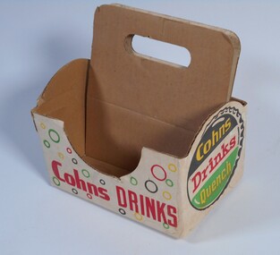 Bendigo Historical Society Inc.
Functional object - Cohns Drink Carrier
Three Danish brothers, Moritz, Julius and Jacob Cohn arrived in Bendigo in 1853. In 1856 they began making cider and soft drinks and two years later built a brewery. Cohn Brothers built an empire of breweries, cordial factories, hotels and liquor stores. In 1925 they sold the hotels and breweries to Carlton & United but continued to make their other products until the 1970s when the company became part of the Coca-Cola Amatil Group. A cardboard carrier for six small bottles. Its 19 centimeters long and 13 centimetres wide. There are two cardboard pieces in the middle which are 18 centimetres heigh and have a slot near the top for fingers which is nine centimetres long and two centimetres wide. The carrier is a cream colour and has red, green, yellow and black small circles and writing on it COHNS DRINKS QUENCH.cohns drinks, cohns drink carrier -
 Whitehorse Historical Society Inc.
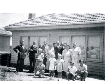
Photograph, Roger de Stoop and Belgian workers, C 1950
Roger de Stoop came to Australia during the Second World War when the de Stoop spinning & weaving factory in Belgium was closed during the German occupation. He had previously met Dick Best, an Australian who wanted to establish a textile factory in Australia and in 1950 they built a factory at Blackburn North importing the weaving looms and many of their skilled workers from Belgium. Housing for the workers was built near the factory.Black and white photograph of Belgian family groups in front of one of the houses erected for the de Stoop workers. Roger de Stoop is in the centre of the photograph in a dark suit and tie.de stoop, roger. de stoop aust pty ltd. de stoop and best textile factory. weaving mills. belgians in australia