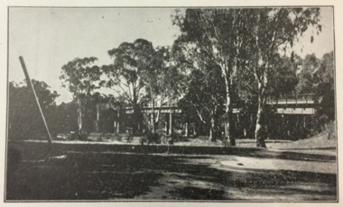
Showing 10682 items matching "east melbourne"
-
 Frankston RSL Sub Branch
Saddle
This saddle formerly belonged to MAX ARMSTRONG a WW2 ex-serviceman and a Frankston RSL Sub Branch member. Max and other ex-service officers were members of a volunteer Light Horse Mounted Section who, for many years, rode at the head of the annual Melbourne ANZAC Day commemoration March, leading the marching troops. At the completion of the march the Light Horse Mounted Section would visit the Memorial Horse Trough near the north east corner of the Shrine of Remembrance for a brief service paying tribute to Australian war horses.A WW1 era Australian Light Horse riding saddle. The saddle is a 1915 pattern Officers riding saddle, made of leather and is complete. The saddle is displayed on a wooden frame. -
 Bendigo Military Museum
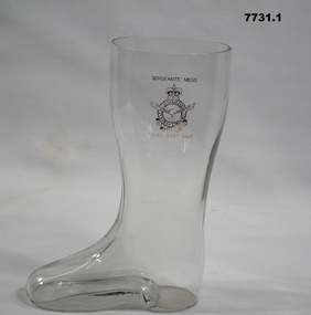
Functional object - DRINKING GLASSES
Glasses used in Sergeants Mess for Celebratory occasions, that were collected from various messes.Set of 3 drinking glasses in the shape of a boot. 1. Small boat shape clear glass with heel with Australian Emblem on left side. 2. Medium boot shape drinking glass with heel with Australian Royal Artillery emblem on upper front. 3. Large boot shape clear glass with heel and Australian Royal Artillery emblem on front.1. Inscribed "Sergeants Mess" and "RAAF East Sale". 2. Inscribed "RAAF Sergeants Mess" above emblem and "Melbourne" below emblem. 3. Inscribed " Sergeants Mess" above emblem and "RAAF East Sale" below.raaf, glasses, sergeants mess -
 Kiewa Valley Historical Society
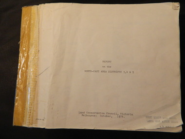
Report - Land Conservation Council x2, Land Conservation Council, Victoria Melbourne, April 1978, October 1974
Land Conservation Act 1970 established the Land Conservation Council to investigate and recommend to the Minister use of public land in Victoria. It describes and assesses the natural resources:-Physiography, Geology, Topography, Land Systems, Outdoor Recreation, Public land and blocks. Primary Production. Vegetation.North East Victoria includes the Kiewa Valley. This report gives an understanding of the development of the area.Thick heavy book with 312 pages with black and white photos. Back half has a folder with heavy cardboard attached to thick cardboard back cover. Inside folder are 9 maps with color each with a different title.Stamped on Front Cover: "Mount Beauty High School" Has a library borrowing slip at the back of the last page.land conservation council, environment, public land, kiewa valley, planning -
 Kiewa Valley Historical Society
Book - Diary - G.P. Lyons SECV x4, 1. Catherine Moss; 2. Crossing the Rubicon; 3. Running the Line; 4. Twilight of the Gods
Geoff Lyons worked initially as a storeman for SECV on the Kiewa Hydro Electric Scheme and later possibly as a linesman on the transmission lines from Mt Beauty to Melbourne.A social history of working in the north east on a construction site. Geoff worked with European migrants in his youth and describes his life as a young man - an interesting comparison to life in the 2020s.4 Books with coloured (2 tones) cardboard cover with hard plastic attached. 1 and 2 books are bound by white plastic strips 3 and 4 are bound with white tape. 1. 1951-52 with 150 pages; 2. 1952-53 with 130 pages; 3. 1954-55 with 101 pages; 4. 1955-56 with 122 pages.All 4 books have "To Colin & Lyn Maxwell from Joy and Geoff Lyons" handwritten on the first page.geoff lyon, storeman, linesman, secv, khes -
 Kiewa Valley Historical Society
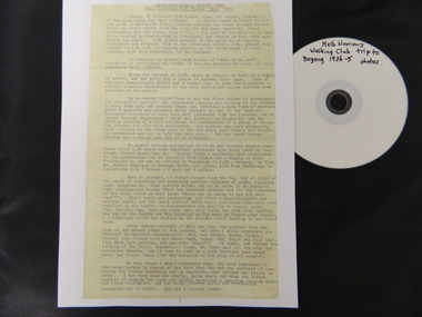
Diary Extract - Trip to Bogong High Plains Xmas 1934 & DVD photos, original diary 1934
The Melbourne Women's Walking Club enjoyed bush walking as a hobby travelling to the north east of Victoria, using pack horses and camping on a 9 day hike. One of the woman, 'Bill' describes each day in detail - what they did, where they went and what they saw giving an insight into walking and the Bogong High Plains in the mid 1930's before the Kiewa Hydro Electric Scheme opened up the area. The diary mentions a photo being taken by Mr Blackwell on the 9th day, New Year's Eve 'from a lovely bush track from which, looking back at intervals we got our final glimpse of Fainter. 5 miles from from our destination'.Historic: This extract from the diary of 'Bill', a member of the Melbourne Women's Walking Club gives an insight into walking in the mid 1930's and describes the Bogong High Plains as it was then before it was opened up with a road built during the Kiewa Hydro Electric Scheme. It describes the area in summer including the flora & fauna, cattle grazing & cattlemen, the huts, the gauges set up by the State Electricity Commission of Victoria, the people working up there, the weather and the lifestyle of the walking group - their food, duties, swimming etc.. Six double sided typed photocopied yellow pages describing the Melbourne Women's Walking Club trip to the Bogong High Plains at Christmas in 1934. Also one page photocopied of the programme for Year 1934-35 with an arrow pointing to the above trip and a page with a photocopied sepia photo of the "Melbourne Women's Walking Club / Bogong High Plains / Dec. 1934. DVD 12 photos of the trip arrow showing trip from Programme. Title of photo "Melbourne Women's Walking Club / Bogong High Plains / Dec. 1934melbourne women's walking club. bogong high plains. camping. pack horses. cattlemen's huts. -
 Christ Church Anglican Parish of Warrnambool
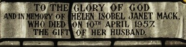
Memorial window: Helen Isobel Janet MACK, "Peace... Goodwill Towards Men"
Helen Isobel Janet Mack was born to parents Gilbert Bailee Nicol and Lizzie (or Lillie) Mary Nicol (nee Jellie) at Woodford, Victoria or Rose Hill Warrong, in approx. 1895. Her mother's parents were James and Sarah Jane Jellie (nee Bower) Her father's parents were Gilbert and Jane Boili Nicol (nee Jelllie) She lived her life here at least until her first marriage. She firstly married a Mr LIndsay and they had two daughters - Helen and Jane. They were later divorced. On 16th February 1935, Helen married Ronald William Mack (a pioneering family of Warrnambool) at the Registry Office in Collins St. Melbourne. They had a son James. It appears Helen lived at 52 Banyan St, including while her husband was absent, until her death. Her husband Ronald William Mack was born in Warrnambool in 1904. He joined the Australian Imperial Forces and was based in the Middle East during some of WW11 and returned to Warrnambool in approx 1943 due to injury. He was involved in the community, and politics and was elected to the Legislative Council in 1955. Janet died on 10th April, 1957, aged 55 years, her funeral leaving Christ Church on April 11th. Her husband had erected in Christ Church, a Memorial Stained Glass window in her memory. Her husband was eventually Knighted (in 1967) while he was Minister for Health of which his main focus was on the mentally ill and the aged. He was then Sir Ronald William Mack. First wife of Sir Ronald William Mack. Stained glass, lancet window, north wall, Hammond Fellowship Centre, Christ Church. Depiction of the Nativity with Mary , Joseph and the infant Jesus"Peace... Goodwill Towards Men"/ To the Glory of God/ and in memory of Helen Isobel Janet Mack,/ who died on 10th April 1957./ The gift of her husband. -
 Port of Echuca
Photograph, Original photo c.1920
The iron bridge was completed in 1878 and was used by the Deniliquin and Moama Railway company for goods trains only - it was another year before passengers were included in the transport service. On 4 March 1879 citizens of Echuca and Moama stormed the bridge, opened the gates and declared it open for their use.At the turn of the century the railway line carried produce from southern New South Wales & the Riverina to Melbourne, with goods trains being a very important mode to transport. When the bridge was being constructed, six workmen were killed and another maimed when a pile on the Moama bank collapsed. After the storming of the bridge by local people in March 1879 it was declared open for use of local residents traveling between the towns of Echuca and Moama. The bridge was shared by rail, road and pedestrian traffic.An image of the iron bridge at Echuca, taken looking East from Victoria bank.Verso: "Iron bridge"murray river bridge , echuca, murray bridge, echuca, iron bridge, echuca -
 Eltham District Historical Society Inc
Photograph, Fay Bridge, Looking north towards Diamond Creek from the high point of Allendale Road, Diamond Creek, n.d
Situated opposite the driveway of 170 Allendale Road, Research, just east of where the Maroondah Aqueduct Trail crosses the roadfay bridge collection, allendale road, diamond creek, fences, research (vic.) -
 Eltham District Historical Society Inc
Photograph - Aerial Photograph, Landata, Eltham / Research, Vic, Jan. 1951
Centred on Brinkkotter Road opposite Yarramie Reserve, Eltham bounded by Maroondah Aqueduct to north, Nyora Road to south, Eltham College to east and Leane Drive to west. Historic Aerial Imagery Source: Landata.vic.gov.au Aerial Photo Details: Project No :65 Project : MELBOURNE AND METROPOLITAN PROJECT NO. 2 Run : 7 Frame : 8 Date : 01/1951 Film Type : B/W Camera : EAG9 Flying Height : 12200 Scale : 12000 Film Number : 1419 GDA2020 : 37°42'32"S, 145°10'41"E MGA2020 : 339408, 5824924 (55) Melways : 22 F3 (ed. 42)Historical aerial photos and photo maps provide viusal evidence of the chronology of changes to the built landscape of the district and assist in dating other imagesaerial photo, 1951-01, eltham, neil webster collection, brinkkotter road, eltham college, leane drive, maroondah aqueduct, melways 22f3, nyora road, yarramie reserve -
 Eltham District Historical Society Inc
Photograph - Aerial Photograph, Landata, Eltham, Vic, Jan. 1951
Centred on Beard Street between Main Road and Frank Street, Eltham bounded by Maroondah Aqueduct to north, Arthur Street to south, Maroong Drive to east and Catholic Ladies College to west. Historic Aerial Imagery Source: Landata.vic.gov.au Aerial Photo Details: Project No :65 Project : MELBOURNE AND METROPOLITAN PROJECT NO. 2 Run : 7 Frame : 9 Date : 01/1951 Film Type : B/W Camera : EAG9 Flying Height : 12200 Scale : 12000 Film Number : 1419 GDA2020 : 37°42'23"S, 145°09'39"E MGA2020 : 337874, 5825170 (55) Melways : 22 B3 (ed. 42)Historical aerial photos and photo maps provide viusal evidence of the chronology of changes to the built landscape of the district and assist in dating other imagesaerial photo, 1951-01, eltham, neil webster collection, arthur street, beard street, catholic ladies college, frank street, main road, maroondah aqueduct, maroong drive, melway 22b3, research (vic.) -
 Eltham District Historical Society Inc
Photograph - Aerial Photograph, Landata, Eltham, Vic, Jan. 1951
Centred on Allison Crecent Reserve, Sherbrook Road and Scenic Crescent, Eltham bounded by Allendale Road to north, Dudley Street to south, Zig Zag Road to east and St Helena Road to west. Historic Aerial Imagery Source: Landata.vic.gov.au Aerial Photo Details: Project No :65 Project : MELBOURNE AND METROPOLITAN PROJECT NO. 2 Run : 7 Frame : 10 Date : 01/1951 Film Type : B/W Camera : EAG9 Flying Height : 12200 Scale : 12000 Film Number : 1419 GDA2020 : 37°42'14"S, 145°08'36"E MGA2020 : 336339, 5825416 (55) Melways : 21 H2 (ed. 42)Historical aerial photos and photo maps provide viusal evidence of the chronology of changes to the built landscape of the district and assist in dating other imagesaerial photo, 1951-01, eltham, neil webster collection, allendale road, allison crecent reserve, dudley street, melway 21h2, scenic crescent, sherbrook road, st helena road, zig zag road -
 Eltham District Historical Society Inc
Photograph - Aerial Photograph, Landata, Eltham North, Feb. 1956
Centred on present day 54 Kelway Crescent, Eltham North bounded by Glen Gully Road to north, Meruka Drive to south, Eltham College to east and Leach Street to west. Historic Aerial Imagery Source: Landata.vic.gov.au Aerial Photo Details: Project No :250 Project : MELBOURNE OUTER SUBURBS PROJECT Run : 17 Frame : 113 Date : 02/1956 Film Type : B/W Camera : EAG9 Flying Height : 10000 Scale : 12000 Film Number : 1176 GDA2020 : 37°42'16"S, 145°08'08"E MGA2020 : 335650, 5825336 (55) Melways : 21 G2 (ed. 42)aerial photo, 1956-02, eltham, eltham north, glen gully road, leach street, main road, melway 21g2, meruka drive, montmorency, neil webster collection -
 Eltham District Historical Society Inc
Photograph - Aerial Photograph, Landata, Montmorency, Feb. 1956
Centred on present day Tahlee Place Reserve and Sherbourne Preschool, Montmorency bounded by Progress Road to north, Withers Way to south, Main Road to east and Leach Street to west. Historic Aerial Imagery Source: Landata.vic.gov.au Aerial Photo Details: Project No :250 Project : MELBOURNE OUTER SUBURBS PROJECT Run : 17 Frame : 114 Date : 02/1956 Film Type : B/W Camera : EAG9 Flying Height : 10000 Scale : 12000 Film Number : 1176 GDA2020 : 37°42'50"S, 145°08'02"E MGA2020 : 335512, 5824286 (55) Melways : 21 F5 (ed. 42)aerial photo, 1956-02, neil webster collection, central park, eltham, leach street, main road, melway 21f5, montmorency, progress road, withers way, sherbourne preschool, tahlee place reserve -
 Eltham District Historical Society Inc
Photograph - Aerial Photograph, Landata, Montmorency, Feb. 1956
Centred on present day Grand Boulevard and Olympic Way, Montmorency bounded by Diamond Street to north, Old Eltham Road and Eltham Lower Park to south, Bible Street to east and Para Road to west. Historic Aerial Imagery Source: Landata.vic.gov.au Aerial Photo Details: Project No :250 Project : MELBOURNE OUTER SUBURBS PROJECT Run : 17 Frame : 115 Date : 02/1956 Film Type : B/W Camera : EAG9 Flying Height : 10000 Scale : 12000 Film Number : 1176 GDA2020 : 37°43'24"S, 145°07'55"E MGA2020 : 335375, 5823236 (55) Melways : 21 F7 (ed. 42)aerial photo, 1956-02, neil webster collection, eltham, main road, montmorency, bible street, diamond street, eltham lower park, grand boulevard, melway 21f7, old eltham road, olympic way, para road -
 Eltham District Historical Society Inc
Photograph - Aerial Photograph, Landata, Lower Plenty, Feb. 1956
Centred on present day 217 Old Eltham Road, Lower Plenty bounded by Pitt Street to north, Yarra River to south, Main Road to east and Bonds Road to west. Historic Aerial Imagery Source: Landata.vic.gov.au Aerial Photo Details: Project No :250 Project : MELBOURNE OUTER SUBURBS PROJECT Run : 17 Frame : 116 Date : 02/1956 Film Type : B/W Camera : EAG9 Flying Height : 10000 Scale : 12000 Film Number : 1176 GDA2020 : 37°43'58"S, 145°07'49"E MGA2020 : 335237, 5822186 (55) Melways : 21 E10 (ed. 42)aerial photo, 1956-02, neil webster collection, eltham, main road, bonds road, elham, lower plenty, melway 21e10, pitt street, yarra river -
 Eltham District Historical Society Inc
Photograph - Aerial Photograph, Landata, Eltham, Feb. 1956
Centred on present day Culla Hill and Petty's Orchard, Eltham bounded by Brougham Street and Mount Pleasant Road to north, Monckton Road, Templestowe to south, Reynolds Road to east and Eltham Lower Park and Hohnes Road to west. Historic Aerial Imagery Source: Landata.vic.gov.au Aerial Photo Details: Project No :250 Project : MELBOURNE OUTER SUBURBS PROJECT Run : 18 Frame : 92 Date : 02/1956 Film Type : B/W Camera : EAG9 Flying Height : 10000 Scale : 12000 Film Number : 1176 GDA2020 : 37°43'35"S, 145°09'31"E MGA2020 : 337735, 5822959 (55) Melways : 22 B8 (ed. 42)aerial photo, 1956-02, neil webster collection, eltham, brougham steet, culla hill, eltham lower park, hohnes road, melway 22b8, monckton road, mount pleasant road, petty's orchard, reynolds road, sweeneys lane, templestowe, yarra river -
 Eltham District Historical Society Inc
Photograph - Aerial Photograph, Landata, Eltham, Feb. 1956
Centred on present day Mount Plaeasant Road near Dalton Street, Eltham bounded by Luck Street to north, Eltham Lower Park to south, Reynolds Road to east and Central Park to west Historic Aerial Imagery Source: Landata.vic.gov.au Aerial Photo Details: Project No :250 Project : MELBOURNE OUTER SUBURBS PROJECT Run : 18 Frame : 93 Date : 02/1956 Film Type : B/W Camera : EAG9 Flying Height : 10000 Scale : 12000 Film Number : 1176 GDA2020 : 37°43'02"S, 145°09'38"E MGA2020 : 337871, 5823961 (55) Melways : 22 B6 (ed. 42)aerial photo, 1956-02, neil webster collection, eltham, central park, eltham lower park, luck street, melway 22b6, nyora road, reynolds road, dalton street, mount pleasant road -
 Eltham District Historical Society Inc
Photograph - Aerial Photograph, Landata, Eltham, Feb. 1956
Centred on present day Shalbury Avenue, Eltham bounded by Leane Drive and Parsons Road to north, Nyora Road to south, Reynolds Road to east and the Diamond Creek to west Historic Aerial Imagery Source: Landata.vic.gov.au Aerial Photo Details: Project No :250 Project : MELBOURNE OUTER SUBURBS PROJECT Run : 18 Frame : 95 Date : 02/1956 Film Type : B/W Camera : EAG9 Flying Height : 10000 Scale : 12000 Film Number : 1176 GDA2020 : 37°41'57"S, 145°09'51"E MGA2020 : 338145, 5825965 (55) Melways : 22 C1 (ed. 42)aerial photo, 1956-02, neil webster collection, eltham, diamond creek (creek), melway 22c1, nyora road, parsons road, reynolds road, shalbury avenue -
 Eltham District Historical Society Inc
Photograph - Aerial Photograph, Landata, Eltham, Vic, Feb. 1956
Centred on present day Parsons Avenue at Leane Drive near the Maroondah Aqueduct, Eltham bounded by Lorimer Road to north, Thompson Crescent and Norman Road to south, Bells Hill Road to east and Parsons Road to west Historic Aerial Imagery Source: Landata.vic.gov.au Aerial Photo Details: Project No :250 Project : MELBOURNE OUTER SUBURBS PROJECT Run : 19 Frame : 5 Date : 02/1956 Film Type : B/W Camera : EAG9 Flying Height : 10000 Scale : 12000 Film Number : 1176 GDA2020 : 37°42'04"S, 145°11'09"E MGA2020 : 340064, 5825786 (55) Melways : 22 H1 (ed. 42)aerial photo, 1956-02, neil webster collection, allendale road, bells hill road, eltham, leane drive, lorimer road, maroondah aqueduct, melway 22h1, norman road, parsons road, research (vic.), thompson crescent -
 Eltham District Historical Society Inc
Photograph - Aerial Photograph, Landata, Research, Vic, Feb. 1956
Centred on present day Thompson Crescent, Research bounded by Maroondah Aqueduct to north, Thompson Crescent and Nyora Road to south, Bells Hill Road to east and Eucalyptus Road to west Historic Aerial Imagery Source: Landata.vic.gov.au Aerial Photo Details: Project No :250 Project : MELBOURNE OUTER SUBURBS PROJECT Run : 19 Frame : 6 Date : 02/1956 Film Type : B/W Camera : EAG9 Flying Height : 10000 Scale : 12000 Film Number : 1176 GDA2020 : 37°42'38"S, 145°11'02"E MGA2020 : 339927, 5824736 (55) Melways : 22 H4 (ed. 42)aerial photo, 1956-02, neil webster collection, bells hill road, eltham, eucalyptus road, maroondah aqueduct, melway 22h4, nyora road, research (vic.), thompson crescent -
 Eltham District Historical Society Inc
Photograph - Aerial Photograph, Landata, Eltham, Vic, Apr. 1963
Centred on present day Zig Zag Road and Main Road, Eltham bounded by Maroondah Aqueduct to north, Thompson Crescent and Arthur Street to south, Parsons Road to east and Glen Park Road and Banks Road to west. Historic Aerial Imagery Source: Landata.vic.gov.au Aerial Photo Details: Project No :486 Project : MELBOURNE (1963) PROJECT Run : 5 Frame : 59 Date : 04/1963 Film Type : B/W Camera : RC8 Flying Height : 5100 Scale : 9600 Film Number : 1805 GDA2020 : 37°42'24"S, 145°08'52"E MGA2020 : 336716, 5825114 (55) Melways : 21 J3 (ed. 42)aerial photo, neil webster collection, eltham, 1963-04, arthur street, banks road, glen park road, maroondah aqueduct, melway 21j3, parsons road -
 Eltham District Historical Society Inc
Photograph - Aerial Photograph, Landata, Eltham, Vic, Apr. 1963
Centred on present day Floriston Grove, Eltham bounded by Maroondah Aqueduct to north, Thompson Crescent and Diosma Road to south, Research Shops to east and Glen Park Road and Park West Road to west. Historic Aerial Imagery Source: Landata.vic.gov.au Aerial Photo Details: Project No :486 Project : MELBOURNE (1963) PROJECT Run : 5 Frame : 60 Date : 04/1963 Film Type : B/W Camera : RC8 Flying Height : 5100 Scale : 9600 Film Number : 1805 GDA2020 : 37°42'24"S, 145°09'29"E MGA2020 : 337622, 5825128 (55) Melways : 22 B3 (ed. 42)aerial photo, neil webster collection, eltham, 1963-04, diosma road, floriston grove, maroondah aqueduct, melway 22b3, park west road, research (vic.), research shops -
 Eltham District Historical Society Inc
Photograph - Aerial Photograph, Landata, Research, Vic, Apr. 1963
Centred on present day Thompson Crescent and Nicholson Close, Research bounded by Maroondah Aqueduct to north, Nyora Road to south, Eltham College to east and Eltham Gateway Hotel to west. Historic Aerial Imagery Source: Landata.vic.gov.au Aerial Photo Details: Project No :486 Project : MELBOURNE (1963) PROJECT Run : 5 Frame : 61 Date : 04/1963 Film Type : B/W Camera : RC8 Flying Height : 5100 Scale : 9600 Film Number : 1805 GDA2020 : 37°42'24"S, 145°10'06"E MGA2020 : 338528, 5825143 (55) Melways : 22 D3 (ed. 42)aerial photo, neil webster collection, eltham, 1963-04, eltham college, eltham gateway hotel and conference centre, maroondah aqueduct, melway 22d3, nicholson close, nyora road, research (vic.), thompson crescent -
 Eltham District Historical Society Inc
Photograph - Aerial Photograph, Landata, Research, Vic, Apr. 1963
Centred on present day Marconi Court, Research bounded by Maroondah Aqueduct to north, Thompson Crescent to south, Joselyn Drive to east and Eltham Research Oval to west. Historic Aerial Imagery Source: Landata.vic.gov.au Aerial Photo Details: Project No :486 Project : MELBOURNE (1963) PROJECT Run : 5 Frame : 62 Date : 04/1963 Film Type : B/W Camera : RC8 Flying Height : 5100 Scale : 9600 Film Number : 1805 GDA2020 : 37°42'24"S, 145°10'43"E MGA2020 : 339434, 5825157 (55) Melways : 22 F3 (ed. 42)aerial photo, neil webster collection, 1963-04, joselyn drive, marconi court, melway 22f3, research (vic.), research oval, thompson crescent -
 Eltham District Historical Society Inc
Photograph - Aerial Photograph, Landata, Eltham, Vic, Apr. 1963
Centred on present day John Street, Eltham between Main and Bible streets bounded by Elsa Court to north, Main Road Bridge to south, Wattle Grove to east and Bolton Street to west. Historic Aerial Imagery Source: Landata.vic.gov.au Aerial Photo Details: Project No :486 Project : MELBOURNE (1963) PROJECT Run : 6 Frame : 123 Date : 04/1963 Film Type : B/W Camera : RC8 Flying Height : 5100 Scale : 9600 Film Number : 1805 GDA2020 : 37°43'12"S, 145°08'54"E MGA2020 : 336800, 5823623 (55) Melways : 21 J6 (ed. 42)aerial photo, neil webster collection, 1963-04, bolton steet, elsa court, eltham, john street, main road, main road bridge, melway 21j6, wattle grove -
 Eltham District Historical Society Inc
Photograph - Aerial Photograph, Landata, Eltham, Vic, Apr. 1963
Centred on present day Eltham Ridge, Bolton Street, Eltham bounded by Elsa Court to north, Main Road to south, Bible Street to east and Reichelt Avenue and Rattray Road to west. Historic Aerial Imagery Source: Landata.vic.gov.au Aerial Photo Details: Project No :486 Project : MELBOURNE (1963) PROJECT Run : 6 Frame : 124 Date : 04/1963 Film Type : B/W Camera : RC8 Flying Height : 5100 Scale : 9600 Film Number : 1805 GDA2020 : 37°43'12"S, 145°08'16"E MGA2020 : 335876, 5823604 (55) Melways : 21 G6 (ed. 42)aerial photo, neil webster collection, 1963-04, bible street, bolton street, eltham, eltham ridge, main road, montmorency, rattray road, reichelt avenue -
 Eltham District Historical Society Inc
Photograph - Aerial Photograph, Landata, Lower Plenty, Vic, Apr. 1963
Centred on present day Old Eltham Road near Araluen Centre, Lower Plenty bounded by Cromwell Street to north, Yarra River to south, Main Road at Mount Pleasant Road to east and Panorama Avenue to west. Historic Aerial Imagery Source: Landata.vic.gov.au Aerial Photo Details: Project No :486 Project : MELBOURNE (1963) PROJECT Run : 7 Frame : 231 Date : 04/1963 Film Type : B/W Camera : RC8 Flying Height : 5100 Scale : 9600 Film Number : 1805 GDA2020 : 37°44'03"S, 145°07'56"E MGA2020 : 335420, 5822027 (55) Melways : 21 F10 (ed. 42)aerial photo, neil webster collection, 1963-04, araluen, cromwell street, eltham, lower plenty, main road, melway 21f10, mount pleasant road, old eltham road, panorama avenue, yarra river -
 Eltham District Historical Society Inc
Photograph - Aerial Photograph, Landata, Eltham, Vic, Apr. 1963
Centred on present day Eltham Lower Park bounded by Brougham Street to north, Yarra River and Fitzsimons Lane Bridge to south, Main Road at Kent Hughes Road to east and Bolton Street to west. Historic Aerial Imagery Source: Landata.vic.gov.au Aerial Photo Details: Project No :486 Project : MELBOURNE (1963) PROJECT Run : 7 Frame : 232 Date : 04/1963 Film Type : B/W Camera : RC8 Flying Height : 5100 Scale : 9600 Film Number : 1805 GDA2020 : 37°44'03"S, 145°08'33"E MGA2020 : 336329, 5822040 (55) Melways : 21 H10 (ed. 42)aerial photo, neil webster collection, 1963-04, bolton steet, brougham steet, eltham, eltham lower park, fitzsimons lane bridge, kent hughes road, melway 21h10, yarra river -
 Eltham District Historical Society Inc
Photograph - Aerial Photograph, Landata, Eltham, Vic, Apr. 1963
Centred on present day Griffith Park Road, Eltham bounded by Mount Pleasant Road to north, Yarra River and Templestowe to south, Main Road at Reynolds Road to east and Falkiner Street to west. Historic Aerial Imagery Source: Landata.vic.gov.au Aerial Photo Details: Project No :486 Project : MELBOURNE (1963) PROJECT Run : 7 Frame : 233 Date : 04/1963 Film Type : B/W Camera : RC8 Flying Height : 5100 Scale : 9600 Film Number : 1805 GDA2020 : 37°44'04"S, 145°09'10"E MGA2020 : 337237, 5822053 (55) Melways : 22 A10 (ed. 42)aerial photo, neil webster collection, 1963-04, eltham, falkiner street, griffith park road, melway 22a10, mount pleasant road, reynolds road, templestowe, yarra river -
 Eltham District Historical Society Inc
Photograph - Aerial Photograph, Landata, Eltham North, Vic, Apr. 1972
Centred on present day Eltham North reserve near Eltham North Primary School, Eltham North bounded by Allendale Road to north, Bellevue Road to south, Zig Zag Road and Beard Street to east and Ryans Road to west. Historic Aerial Imagery Source: Landata.vic.gov.au Aerial Photo Details: Project No :985 Project : MELBOURNE 1972 Run : 26 Frame : 190 Date : 04/1972 Film Type : B/W Camera : RC10 Flying Height : 5700 Scale : 9600 Film Number : 2636 GDA2020 : 37°41'52"S, 145°08'52"E MGA2020 : 336705, 5826102 (55) Melways : 11 J12 (ed. 42)aerial photo, neil webster collection, 1972-04, allendale road, beard street, bellevue road, eltham, eltham north, eltham north reserve, melway 11j12, ryans road, zig zag road, eltham north primary school