Showing 526 items matching "public works melbourne"
-
 Port Melbourne Historical & Preservation Society
Letter - Public Works Department re new bridge over Yarra at Swanston Street, Public Works Department, 19 May 1880
Letter from Public Works Department, 1880, on conference regarding new bridge over Yarra at Swanston Streetengineering - bridges, town planning, michael tarver quinn -
Port Melbourne Historical & Preservation Society
Document - Memo, Public Works Office re new bridge over Yarra, 21 Jul 1879
Memo from Public Works Office July 1879 regarding new bridge over Yarraengineering - bridges, town planning -
 Port Melbourne Historical & Preservation Society
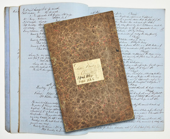
Administrative record - Minute Book, Public Works Committee, Borough of Sandridge, 1864 - 1865
A.09.03.DB Council of the Borough of Sandridge . Minutes of the proceedings of the Public Works Committee April 1864 to September 1865local government - borough of sandridge, andrew plummer, john pickles, edward clark, town clerks -
Port Melbourne Historical & Preservation Society
Book - Municipality of Sandridge, Public Works Committee, reports, 1860
Municipality of Sandridge, Reports of the Public Works Committee from August 2nd 1860 to August 2nd 1861, 1st year information on opening page. reports actually continue to 21 September 1865. Wide spined binder with hand written reports on blue lined paper stuck in, red binding on corners of coverlocal government - borough of sandridge, local government - municipal district of sandridge -
 Women's Art Register
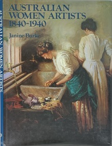
Book, Janine Burke, Australian Women Artists 1840 - 1940, 17/04/22
A history of Australian women artists, the lives and practice of 24 women are covered to redress their absence in critical and art historical records.non-fictionA history of Australian women artists, the lives and practice of 24 women are covered to redress their absence in critical and art historical records. painting, water colour, portraiture, print making -
 Women's Art Register
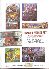
Book, Eva Cockcroft, John Weber, James Cockcroft, Towards a People's Art. The Contemporary Mural Movement, 1977
Written by two muralists and a sociologists the book documents the community based mural movement in the late 60s and early 70s in Canada and the USA.Booknon-fictionWritten by two muralists and a sociologists the book documents the community based mural movement in the late 60s and early 70s in Canada and the USA.political art, revolutionary art, community arts, large scale works -
Port Melbourne Historical & Preservation Society
Document - Memo, Department of Public Works re Williamstwon Short Road, 12 Sep 1887
Items 598.01-.04 originally pinned togetherFoolscap, printed single page copy of Dept of Public Works memo re Williamstown Short Road, dated 12 Sept 1887; original memo dated 19.8.1887. Includes costs of grading road.engineering - roads streets lanes and footpaths, edward clark, town clerks, william thwaites -
Port Melbourne Historical & Preservation Society
Letter - Department of Public Works to Town Clerk re Williamstown Road, 15 Mar 1888
Letter from Department of Public Works 15 March 1888 to Town Clerk Port Melbourne re Williamstown RoadNotes by E.C. Clark in marginengineering - roads streets lanes and footpaths, edward clark, town clerks -
Port Melbourne Historical & Preservation Society
Document - Notice, Attendance at deputation to Public Work re Williamstown Road grant, Edward Clark, Town Clerk, 26 Mar 1888
Items 598.01-.04 originally pinned togetherSmall (4 pg) notice printed front only, inviting attendance at deputation to Public Works re Williamstown Road grant on 27.3.1888'(Copy)' in ink at topengineering - roads streets lanes and footpaths, edward clark, town clerks -
Port Melbourne Historical & Preservation Society
Financial record - Payment advice, Melbourne Water Supply from Borough of Sandridge Council, 1880s
Payment advice for water from Melbourne Water Supply approved by public works committee, examined by finance committee, passed for payment by Sandridge Councilsport - lawn bowls, parks and gardens, port melbourne bowling club, henry norval edwards, michael tarver quinn, local government - borough of sandridge -
Port Melbourne Historical & Preservation Society
Book - Minutes, Town of Port Melbourne, various special committees, 1890 - 1902
Book containing minutes of various special committees of the Town of Port Melbourne, 1890 to 1902: Special committee of retrenchment 06.05.1890 - 09.07.1890 (pp 1-9): Rate collecting committee 30.09.1890, p.15: Public works, finance and legilative and sanitary business 30.08.1892, pp. 20-22: Arrears of rates committee 05.04.1898, p.24: Rates committee 17.02.1902, p. 28: Revision of bye-laws sub-committee 18.04.1899, p.60local government - town of port melbourne -
 Coal Creek Community Park & Museum
Labels, resin
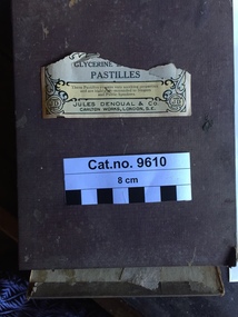
Reference 'Elix TaraxacCo Squam' (Elixar Taraxaccum squamosum or T. squamulosum: Flora of Victoria : 'Taraxacum squamulosum, Soest Dandelion, Acta Bot. Neerl. 6: 413 (1957) APNI, Taxonomic status : Accepted, Occurrence status : Present, Establishment means : Naturalised'. 'AC. TARTAR', 'TR. DIGITAL.' (Digitalis sp.), 'POTASS : CARB' (Potassium Carbonate) , ' ...Quillaia',(Quillaja saponaria), 'Tinct.Calumbae' (Tincture Calumbae : root of Jateorhiza Columba), 'TR.CIMICIF.' (Tincture of Cimicifuga sp. possibly C.racemosa), 'ESS.ROSAS' (Essence of roses), ' ..ubi Acet.' (??? acetate /acetone), 'POISON Liq. Hyd. Perchlor.' (Liquid hydrogen perchloride), 'LIN. CAMPH. CO.', 'INF. AU...', '..RANTI', 'OL. ORIGA..', '..FERR.DIAL'.Numerous entire, most damaged celluloid apothecary jar labels with black text on white background, bounded by red and gold border. Some paper apothecary jar labels, mostly damaged, all in a purple paper covered cardboard box originally containing self adhesive plasters.On side of purple box a white paper label with text inside black rimmed circle 'PODOPHYLL.........Pill....Dose.....One....HOOD & CO CHEMISTS 215 Elizabeth Street, MELBOURNE'. Inside lid of box : 'ZINCOPLACT Regd. SELF ADHESIVE PLASTER. INVALUABLE FOR CUTS,SMALLWOUNDS ETC. ANTISEPTIC Can also be used for binding and sealing jars and bottles, cricket bats and the like. ONE YARD TINS 1/2 inch 1 inch and 1 1/2 inch wide. The same quality as used by Surgeons and ....Hospitals throughout .....World. ZINCOPLAST LESLIES LTD This plaster causes no irritation and withstands washing ........I.....ingredients are exceptionally pure. MANUFACTURED BY LESLIES, LIMD. LONDON ENG'. One damaged paper label '......GLYCERINE......... PASTILLES These pastilles possess very soothing properties and are highly recommended to Singers and Public Speakers. TRADE JD MARK JULES DENOUL & CO. CARLTON WORKS, LONDON, S.E. TRADE JD MARK'. Paper label :'Elix TaraxacCo Squam HOOD & CO., (F. W. BAIRD.) Pharmaceutical Chemists 215 ELIZABETH ST., MELBOURNE.' Series of celluloid bottle labels : 'AC. TARTAR', 'TR. DIGITAL.', 'POTASS : CARB', ' ...Quillaia', 'Tinct. Calumbae', 'TR.CIMICIF.', 'ESS.ROSAS', ' ..ubi Acet.', 'POISON Liq. Hyd. Perchlor.', 'LIN. CAMPH. CO.', 'INF. AU...', '..RANTI', 'OL. ORIGA..', '..FERR.DIAL'.pharmacopeia, nomenclature, labels, packaging -
 Port Melbourne Historical & Preservation Society
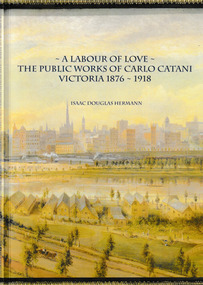
Book, Isaac Douglas Hermann, A Labour of Love The Public works of Carlo Catani Victoria 1876 - 1918, October 2021
The book covers all the Victorian Public Works projects of Carlo CATANI including the Catani Memorial Clock Tower & the Catani Gardens in St Kilda. Book, 'A Labour of love - the Public Works of Carlo Catani Victoria 1876 - 1918'. The front & back covers are from a 1905 painting by Laurence WILSON showing the southern approach to Melbourne and with Princes Bridge and the Yarra River.carlo catani, carlo catani memorial clock tower, catani gardens -
 Port Melbourne Historical & Preservation Society
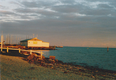
Photograph - Port Melbourne foreshore, Carolyn Goldberg, 1988
Ten coloured photographs taken in 1988 by Carolyn Goldberg (.01)&(.02) Photos of the Port Melbourne Yacht Club (pre fire). One is taken at distance. (.03)&(.04) Photos of Princes Pier locked up and abrred to public access (.05)&(.06) Photos of cranes on Station Pier. One taken at greater distance from Princes Pier (.07) The engine works building on future Beacon Cove site (.08)&(.09)Two views of the Centenary Bridge. One at greater distance. (.10)Photo of the area now known as Beacon Cove with City in distant backgroundpiers and wharves - station pier, piers and wharves - princes pier, societies clubs unions and other organisations, sport - yachting, built environment - civic, built environment - domestic, centenary bridge, carolyn goldberg, commonwealth engine works, port melbourne yacht club, pmyc, cranes (stodart?), liardet's beach, beacon cove -
 Melbourne Water
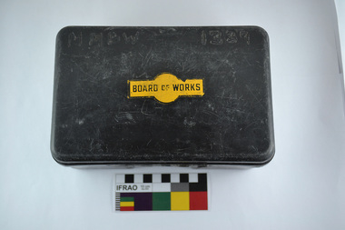
First Aid Kit (plastic lunch box), 1970s
As the Yarra became unsuitable as a source of water, several attempts were made to find alternative sources for the growing population of Melbourne. It was not until 1891 that the efforts to sewer Melbourne came to fruition with the setting up of the Melbourne Metropolitan Board of Works (MMBW), now known as Melbourne Water. From 1891 until 1992, it was the responsibility of the MMBW to safeguard public health by providing a sewerage system and a safe water supply system. In 1992, The MMBW merged with a number of smaller urban water authorities to form Melbourne Water.This first aid kit is of historical significance for its association with the former Melbourne and Metropolitan Board of Works (MMBW). The kit is relatively intact and a rare surviving object of standard Board issued equipment. The kit is significant for its representativeness of the theme of Safety that continues to resonate strongly within Melbourne Water today. First Aid Kit (plastic lunch box)MMBW 1339 (burnt into plastic) Board of Works Decalmelbourne metropolitan board of works, melbourne water, first aid kit, mmbw, safety, water, sewerage -
 Melbourne Water
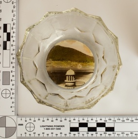
Souvenir confectionery bowl, 1930s-40s
Melbourne Water inherited many of its water assets, such as reservoirs from its predecessor the Melbourne Metropolitan Board of Works (MMBW). They have served the organisation well and have long been celebrated for both their natural beauty and engineering ingenuity. In the nineteenth century Victoria’s fundamental need for water infrastructure went beyond merely functional solutions and reflected the English ideal of the romance and beauty that was embodied in expanses of water. The MMBW further enhanced this notion by incorporating beauty and function in to the Classical and Italianate designs of its infrastructure such as pumping houses and reservoir outlet towers. The reservoir gardens and picnic areas were landscaped with ornamental stonework, exotic trees, decorative flower beds, fern glades pools and rose gardens. All features of the water supply system became widely celebrated as beauty spots that continue to be very popular to this day with tourists and locals alike. This souvenir is a product of that flourishing tourist trade. These water supply sites continue to enhance Melbourne’s charm and liveability and are now recognised as places of cultural and historic significance. This souvenir item has been curated by Melbourne Water as it represents an important historical aspect of the organisation by demonstrating the popularity of its water asset sites as recreational places and tourist attractions, and although these sites are functional parts of the water supply system, they were also designed to be enjoyed by the public both aesthetically and recreationally. Clear glass flower shaped 'depression ware' confectionery bowl, with photographic image of Maroondah Reservoir outlet tower on basemelbourne metropolitan board of works, mmbw, maroondah reservoir, melbourne water, scenic view, souvenir, glass bowl -
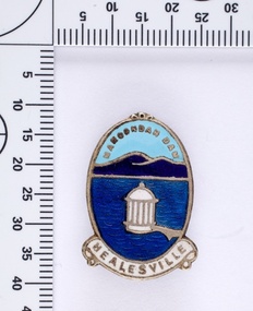 Melbourne Water
Souvenir lapel pin/brooch Maroondah Dam, 1960s/70s
Melbourne Water inherited many of its water assets, such as reservoirs from its predecessor the Melbourne Metropolitan Board of Works (MMBW). They have served the organisation well and have long been celebrated for both their natural beauty and engineering ingenuity. In the nineteenth century Victoria’s fundamental need for water infrastructure went beyond merely functional solutions and reflected the English ideal of the romance and beauty that was embodied in expanses of water. The MMBW further enhanced this notion by incorporating beauty and function in to the Classical and Italianate designs of its infrastructure such as pumping houses and reservoir outlet towers. The reservoir gardens and picnic areas were landscaped with ornamental stonework, exotic trees, decorative flower beds, fern glads pools and rose gardens. All features of the water supply system became widely celebrated as beauty spots that continue to be very popular to this day with tourists and locals alike. This souvenir is a product of that flourishing tourist trade. These water supply sites continue to enhance Melbourne’s charm and liveability and are now recognised as places of cultural and historic significance. This souvenir item has been curated by Melbourne Water as it represents an important historical aspect of the organisation by demonstrating the popularity of its water asset sites as recreational places and tourist attractions, and although these sites are functional parts of the water supply system, they were also designed to be enjoyed by the public both aesthetically and recreationally. Blue enamel and metal lapel pin/brooch depicting Maroondah Reservoir and outlet tower. Oval shaped with words 'Maroondah Dam' at the top and a ribbon banner containing 'Healesville' at the bottom. Maroondah Dam. Healesvillemelbourne metropolitan board of works, mmbw, maroondah reservoir, melbourne water, scenic view, souvenir, lapel pin, brooch -
 Melbourne Water
Photographic View Book, The Melbourne & Metropolitan Board of Works - Water Supply, Sewerage etc. ...Photographic Views, 1908
In 1891 The Melbourne and Metropolitan Board of Works (MMBW) was formed and became responsible for Melbourne's water supply. Melbourne had grown to a city of half a million people. To provide water to this rapidly growing city (especially the eastern suburbs), and to supplement the 1857 Yan Yean Reservoir, Melbourne's first water supply, the Watts River (near Healesville) was tapped. It supplied water to Melbourne, via the Maroondah aqueduct. In May 1892 the MMBW's first engineer-in-chief, Mr William Thwaites began construction on Melbourne's sewerage system. A treatment farm was built at Werribee and a pumping station was built at Spotswood (now the site of the Scienceworks Museum) to send the city's waste to Werribee. The first Melbourne homes were connected to the sewerage system in 1897. This book showcases the MMBW's infrastructure achievements and documents costs, requirements and key personnel involved in the development of the water supply and sewerage schemes.The introduction states "The water supply sources and headworks are in many cases situated in remote places and the sewerage works are chiefly underground. The Board has therefore resolved that these photographs of some of the scenes and works should be collected and bound for general information. August 1908" This book is in excellent condition and provides a detailed insight into the previous 17 years of work and the Board personnel of the MMBW leading up to 1908. It is of historical importance to the history of Melbourne for the photographic documents of places that were not generally open to the public, and for Melbourne Water in its detailed history of the MMBW in the early twentieth century. Photographic view book with hard khaki coloured cardboard cover and blue fabric binding. 120 Pages. Glossy paper with black and white plates and text about the MMBW, and scenic views and places of interest in association with the MMBW. The Melbourne & Metropolitan Board of Works - Water Supply, Sewerage etc. ...Photographic Views...mmbw, board members, sewerage, water supply, historic views, photographs -
 Melbourne Water
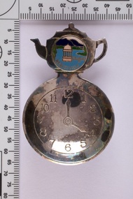
Souvenir tea caddy spoon "Tea Time", Early 1960s
Melbourne Water inherited many of its water assets, such as reservoirs from its predecessor the Melbourne Metropolitan Board of Works (MMBW). They have served the organisation well and have long been celebrated for both their natural beauty and engineering ingenuity. In the nineteenth century Victoria’s fundamental need for water infrastructure went beyond merely functional solutions and reflected the English ideal of the romance and beauty that was embodied in expanses of water. The MMBW further enhanced this notion by incorporating beauty and function in to the Classical and Italianate designs of its infrastructure such as pumping houses and reservoir outlet towers. The reservoir gardens and picnic areas were landscaped with ornamental stonework, exotic trees, decorative flower beds, fern glads pools and rose gardens. All features of the water supply system became widely celebrated as beauty spots that continue to be very popular to this day with tourists and locals alike. This souvenir is a product of that flourishing tourist trade. These water supply sites continue to enhance Melbourne’s charm and liveability and are now recognised as places of cultural and historic significance This souvenir item has been curated by Melbourne Water as it represents an important historical aspect of the organisation by demonstrating the popularity of its water asset sites as recreational places and tourist attractions, and although these sites are functional parts of the water supply system, they were also designed to be enjoyed by the public both aesthetically and recreationally. Tea caddy spoon with clock face engraved showing 4pm on round spoon, tea pot shaped handle with enamel scenic view badge saying 'Healesville' ( depicting Maroondah Reservoir outlet tower). Tea caddy spoon box labelled 'Fine Silverware by Stokes'Stokes and Sons Stokes & Sons logo (Star with S and boomerang) EG. No. 15733melbourne metropolitan board of works, mmbw, maroondah reservoir, melbourne water, scenic view, souvenir, tea caddy spoon -
 Melbourne Water
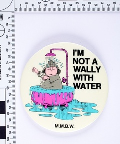
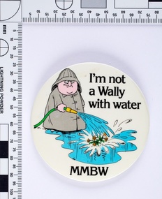
I'm not a Wally with Water badge, 1980s
Following the 1983 Victorian drought The Board of Works (MMBW) ran a television, radio and print campaign to encourage water conservation called ‘Don’t Be a Wally with Water’. The campaign followed Wally, a bumbling, habitual water waster, and is an early example of educating the public on water sustainability both environmentally and financially. Wally was both a cartoon character and played on television by the comedian Peter Moon. The campaign ran for several years and was designed to change attitudes towards water wastage. This MMBW branded item is associated with ‘Don’t Be a Wally with Water’ campaign, and demonstrates an early water sustainability education program. These badges would have been given out as promotional merchandise and at public events. Round metal badge with printed cartoon image and text. -
 Melbourne Water
Souvenir Manicure Set, ELOSI, Maroondah Dam, Healesville Souvenir, c.1940
The Maroondah System was first and foremost developed as a functional component of Melbourne's Water Supply System. In addition to functionality, the Melbourne and Metropolitan Board of Works (MMBW) envisioned the Maroondah Reserve to be enjoyed aesthetically and recreationally by the public. This souvenir illustrates the realisation of the Maroondah System as a local recreational and tourist attraction in the early 20th century. The Maroondah Reserve gardens were landscaped with English-style ornamental stonework, exotic trees, flower beds and rose gardens. All features of the water supply system became widely celebrated as beauty spots that continue to be very popular to this day with tourists and locals alike. This souvenir is a product of that flourishing tourist trade. These water supply sites continue to enhance Melbourne’s charm and liveability and are now recognised as places of cultural and historic significance.This souvenir item has been curated by Melbourne Water as it represents an important historical aspect of the organisation by demonstrating the popularity of its water asset sites as recreational places and tourist attractions, and although these sites are functional parts of the water supply system, they were also designed to be enjoyed by the public both aesthetically and recreationally. This rare pocket grooming kit features a scene of the Maroondah Outlet and Dam. The handle is manufactured from mother-of-pearl, encasing four steel utensils. The utensils contained inside the kit were used for filing and manicuring.Engraved on the back of the last utensil is the manufacturer’s mark “ELOSI”. ELOSI is the acronym from Ernest Lohr and Otto Stiehl of Solingen, Germany. In 1935, this company was the first to manufacture thin plastic covers for low cost (5-25 cents). This is one of the most successful and profitable inventions in the history of cutlery and utensils.melbourne metropolitan board of works, mmbw, maroondah, dam, healesville, melbourne water, scenic view, souvenir, manicureset, historic, germany, rare -
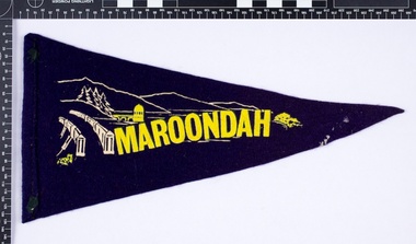 Melbourne Water
Souvenir Pennant
The Maroondah System was first and foremost developed as a functional component of Melbourne's Water Supply System. In addition to functionality, the Melbourne and Metropolitan Board of Works (MMBW) envisioned the Maroondah Reserve to be enjoyed aesthetically and recreationally by the public. This souvenir illustrates the realisation of the Maroondah System as a local recreational and tourist attraction in the early 20th century. The Maroondah Reserve gardens were landscaped with English-style ornamental stonework, exotic trees, flower beds and rose gardens. All features of the water supply system became widely celebrated as beauty spots that continue to be very popular to this day with tourists and locals alike. This souvenir is a product of that flourishing tourist trade. These water supply sites continue to enhance Melbourne’s charm and liveability and are now recognised as places of cultural and historic significance.This souvenir item has been curated by Melbourne Water as it represents an important historical aspect of the organisation by demonstrating the popularity of its water asset sites as recreational places and tourist attractions, and although these sites are functional parts of the water supply system, they were also designed to be enjoyed by the public both aesthetically and recreationally. Navy in colour, the pennant is double sided, with an image of the Maroondah Dam surrounding the word “Maroondah” on both sides.melbourne metropolitan board of works, mmbw, maroondah, dam, healesville, melbourne water, scenic view, souvenir, pennant, flag, textile, historic -
 Melbourne Water
I'm not a Wally with Water badge, 1980s
Following the 1983 Victorian drought The Board of Works (MMBW) ran a television, radio and print campaign to encourage water conservation called "Don't Be a Wally with Water". The campaign followed Wally, a bumbling, habitual water waster, and is an early example of educating the public on water sustainability both environmentally and financially. Wally was both a cartoon character and played on television by the comedian Peter Moon. The campaign ran for several years and was designed to change attitudes towards water wastage.This MMBW branded item is associated with "Don't Be a Wally with Water" campaign, and demonstrates an early water sustainability education program. These badges would have been given out as promotional merchandise and at public events.Round metal badge with printed cartoon image and text. -
 Melbourne Water
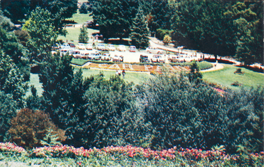
Postcard, The Car Park at Maroondah Reserve, c.1940
The Maroondah System was first and foremost developed as a functional component of Melbourne's Water Supply System. In addition to functionality, the Melbourne and Metropolitian Board of Works (MMBW) envisioned the Maroondah Reserve to be enjoyed aestethically and recreationally by the public. This souvenir postcard illustrates the realisation of the Maroondah System as a local recreational and tourist attraction in the early 20th century. The Maroondah Reserve gardens were landscaped with English-style ornamental stonework, exotic trees, flower beds and rose gardens. All features of the water supply system became widely celebrated as beauty spots that continue to be very popular to this day with tourists and locals alike. This souvenir is a product of that flourishing tourist trade. These water supply sites continue to enhance Melbourne’s charm and liveability and are now recognised as places of cultural and historic significance.This souvenir item represents an important historical aspect of the MMBW by demonstrating the popularity of its water asset sites as recreational places and tourist attractions, and although these sites are functional parts of the water supply system, they were also designed to be enjoyed by the public both aesthetically and recreationally. The souvenir postcard is significant for its documentation of the Maroondah Water Supply System developed through the late nineteenth and early twentieth century, shaping the formative years of Melbourne. The postcard is also historically significant for its association with the MMBW and is viewed as a noteworthy achievement of the organisation. Souvenir coloured rectangular postcard with a framed picture of the carpark at the Maroondah Reserve.melbourne metropolitan board of works, mmbw, maroondah reservoir, melbourne water, scenic view, souvenir -
 Melbourne Water
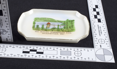
Dish, The Outlet at Maroondah Dam, Souvenir, c.1940
The Maroondah System was first and foremost developed as a functional component of Melbourne's Water Supply System. In addition to functionality, the Melbourne and Metropolitan Board of Works (MMBW) envisioned the Maroondah Reserve to be enjoyed aesthetically and recreationally by the public. This souvenir dish illustrates the realisation of the Maroondah System as a local recreational and tourist attraction in the early 20th century. The Maroondah Reserve gardens were landscaped with English-style ornamental stonework, exotic trees, flower beds and rose gardens. All features of the water supply system became widely celebrated as beauty spots that continue to be very popular to this day with tourists and locals alike. This souvenir is a product of that flourishing tourist trade. These water supply sites continue to enhance Melbourne’s charm and liveability and are now recognised as places of cultural and historic significance.This souvenir item represents an important historical aspect of the MMBW by demonstrating the popularity of its water asset sites as recreational places and tourist attractions, and although these sites are functional parts of the water supply system, they were also designed to be enjoyed by the public both aesthetically and recreationally. The souvenir dish is significant for its documentation of the Maroondah Water Supply System developed through the late nineteenth and early twentieth century, shaping the formative years of Melbourne. The dish is also historically significant for its association with the MMBW and is viewed as a noteworthy achievement of the organisation.Small white porcelain dish with silver trim, 120x75x10mm, with drawing printed in the centre and text reading, "The Outlet, Maroondah Dam, Healesville, Vic." Makers mark, Manufactured in Czechoslovakiamelbourne metropolitan board of works, mmbw, maroondah, outlet, melbourne water, scenic view, souvenir, porcelain, healesville -
 Melbourne Water
Glass Bowl, Maroondah Dam, Healesville Souvenir, 1930s -1940s
The Maroondah System was first and foremost developed as a functional component of Melbourne's Water Supply System. In addition to functionality, the Melbourne and Metropolitan Board of Works (MMBW) envisioned the Maroondah Reserve to be enjoyed aesthetically and recreationally by the public. This souvenir illustrates the realisation of the Maroondah System as a local recreational and tourist attraction in the early 20th century. The Maroondah Reserve gardens were landscaped with English-style ornamental stonework, exotic trees, flower beds and rose gardens. All features of the water supply system became widely celebrated as beauty spots that continue to be very popular to this day with tourists and locals alike. This souvenir is a product of that flourishing tourist trade. These water supply sites continue to enhance Melbourne’s charm and liveability and are now recognised as places of cultural and historic significance.This souvenir item has been curated by Melbourne Water as it represents an important historical aspect of the organisation by demonstrating the popularity of its water asset sites as recreational places and tourist attractions, and although these sites are functional parts of the water supply system, they were also designed to be enjoyed by the public both aesthetically and recreationally. Clear glass flower shaped 'depression ware' bowl with photograph of Maroondah Dam Healesville in the base.melbourne metropolitan board of works, mmbw, maroondah reservoir, melbourne water, scenic view, souvenir, glass, bowl -
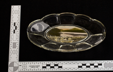
 Melbourne Water
Glass Bowl, Maroondah Dam, Healesville Souvenir, 1930s - 1940s
The Maroondah System was first and foremost developed as a functional component of Melbourne's Water Supply System. In addition to functionality, the Melbourne and Metropolitan Board of Works (MMBW) envisioned the Maroondah Reserve to be enjoyed aesthetically and recreationally by the public. This souvenir illustrates the realisation of the Maroondah System as a local recreational and tourist attraction in the early 20th century. The Maroondah Reserve gardens were landscaped with English-style ornamental stonework, exotic trees, flower beds and rose gardens. All features of the water supply system became widely celebrated as beauty spots that continue to be very popular to this day with tourists and locals alike. This souvenir is a product of that flourishing tourist trade. These water supply sites continue to enhance Melbourne’s charm and liveability and are now recognised as places of cultural and historic significance.This souvenir item has been curated by Melbourne Water as it represents an important historical aspect of the organisation by demonstrating the popularity of its water asset sites as recreational places and tourist attractions, and although these sites are functional parts of the water supply system, they were also designed to be enjoyed by the public both aesthetically and recreationally. Glass bowl with a photograph of the Maroondah Dam in the middle, and text overlay reading "Maroondah Dam, Healesville". melbourne metropolitan board of works, mmbw, maroondah, dam, healesville, melbourne water, scenic view, souvenir, glass bowl -
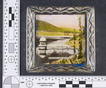
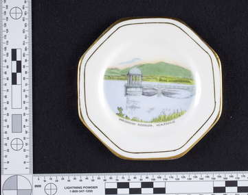 Melbourne Water
Dish, Maroondah Reservoir, Healesville Souvenir, 1930s-1940s
The Maroondah System was first and foremost developed as a functional component of Melbourne's Water Supply System. In addition to functionality, the Melbourne and Metropolitan Board of Works (MMBW) envisioned the Maroondah Reserve to be enjoyed aesthetically and recreationally by the public. This souvenir illustrates the realisation of the Maroondah System as a local recreational and tourist attraction in the early 20th century. The Maroondah Reserve gardens were landscaped with English-style ornamental stonework, exotic trees, flower beds and rose gardens. All features of the water supply system became widely celebrated as beauty spots that continue to be very popular to this day with tourists and locals alike. This souvenir is a product of that flourishing tourist trade. These water supply sites continue to enhance Melbourne’s charm and liveability and are now recognised as places of cultural and historic significance.Manufactured in England, this souvenir dish made from bone china with gold trim, features an illustration of the Maroondah Reservoir in the centre reading, “Maroondah Reservoir, Healesville”. On the back of the dish is the makers mark, Royal Stafford, one of the oldest pottery factories in Staffordshire, England. The Royal Stafford brand was established in 1845 and continues to provide high quality tableware in the present day. This souvenir item has been curated by Melbourne Water as it represents an important historical aspect of the organisation by demonstrating the popularity of its water asset sites as recreational places and tourist attractions, and although these sites are functional parts of the water supply system, they were also designed to be enjoyed by the public both aesthetically and recreationally. Souvenir dish made from bone china with gold trim, featuring an illustration of the Maroondah Reservoir in the centre reading, “Maroondah Reservoir, Healesville”.Makers mark, Royal Stafford.maroondah, healesville, dish, porcelain, melbourne metropolitan board of works, melbourne water, mmbw -
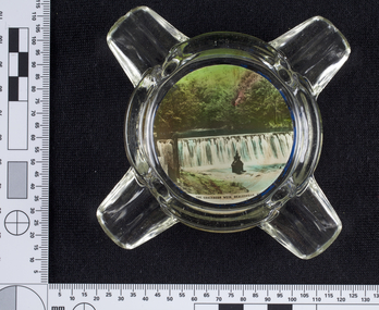 Melbourne Water
Ashtray, Graceburn Weir, Healesville Souvenir, 1930s-1940s
The Maroondah System was first and foremost developed as a functional component of Melbourne's Water Supply System. In addition to functionality, the Melbourne and Metropolitan Board of Works (MMBW) envisioned the Maroondah Reserve to be enjoyed aesthetically and recreationally by the public. This souvenir illustrates the realisation of the Maroondah System as a local recreational and tourist attraction in the early 20th century. The Maroondah Reserve gardens were landscaped with English-style ornamental stonework, exotic trees, flower beds and rose gardens. All features of the water supply system became widely celebrated as beauty spots that continue to be very popular to this day with tourists and locals alike. This souvenir is a product of that flourishing tourist trade. These water supply sites continue to enhance Melbourne’s charm and liveability and are now recognised as places of cultural and historic significance.This souvenir item has been curated by Melbourne Water as it represents an important historical aspect of the organisation by demonstrating the popularity of its water asset sites as recreational places and tourist attractions, and although these sites are functional parts of the water supply system, they were also designed to be enjoyed by the public both aesthetically and recreationally.This Souvenir glass ashtray, used as a receptacle for ash from cigarettes, features a photograph of the Graceburn Weir on the base, with text reading “The Graceburn Weir, Healesville”. Rather small in size, this ashtray has a unique shape with four protruding glass points to place cigarettes. melbourne metropolitan board of works, mmbw, maroondah, dam, healesville, melbourne water, scenic view, souvenir, glass, ashtray, graceburnweir -
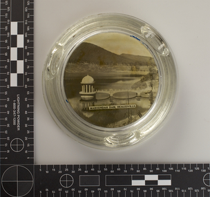 Melbourne Water
Ashtray, Maroondah Dam, Healesville Souvenir, 1930s-1940s
The Maroondah System was first and foremost developed as a functional component of Melbourne's Water Supply System. In addition to functionality, the Melbourne and Metropolitan Board of Works (MMBW) envisioned the Maroondah Reserve to be enjoyed aesthetically and recreationally by the public. This souvenir illustrates the realisation of the Maroondah System as a local recreational and tourist attraction in the early 20th century. The Maroondah Reserve gardens were landscaped with English-style ornamental stonework, exotic trees, flower beds and rose gardens. All features of the water supply system became widely celebrated as beauty spots that continue to be very popular to this day with tourists and locals alike. This souvenir is a product of that flourishing tourist trade. These water supply sites continue to enhance Melbourne’s charm and liveability and are now recognised as places of cultural and historic significance.This souvenir item has been curated by Melbourne Water as it represents an important historical aspect of the organisation by demonstrating the popularity of its water asset sites as recreational places and tourist attractions, and although these sites are functional parts of the water supply system, they were also designed to be enjoyed by the public both aesthetically and recreationally. This Souvenir glass ashtray, used as a receptacle for ash from cigarettes, features a black and white photograph of The Maroondah Dam on the base, with text reading “Maroondah Dam, Healesville”. The ashtray is round in shape with three indents on the rim to place cigarettes. melbourne metropolitan board of works, mmbw, maroondah, dam, healesville, melbourne water, scenic view, souvenir, glass, ashtray