Showing 159 items matching sackville%20street
-
 Kew Historical Society Inc
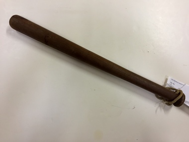
Weapon, Victoria Police, Volunteer Constable's Truncheon, c.1926
Wooden truncheon, used by volunteer constables during 1926 Police strike. Issued to Leslie J Robertson of Sackville St Kew to assist in protecting the stores in Elizabeth Street, Melbourne.The 1926 Police strike was an important event in Victoria's history. As an artefact, issued to volunteers, the truncheon is a remnant of that event.Solid wood varnished police truncheon with cord loop threaded through a hole below where held. These truncheons were issued to volunteer constables during 1926 Police Strike.1926 police strike, volunteer constables, truncheons, batons, police equipment -
 Port Fairy Historical Society Museum and Archives
Photograph, 1940's
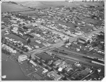
This photograph shows Port Fairy from the air looking down on Douglas House across the rail lines showing Bank Street, Sackville Street, Cox street and to a lesser extent surrounding streetsThis photograph depicts the Streets and river during the 1940's and the buildings that were present at that time some no longer in existenceBlack and white PhotographALEX WILKINS PHOTOGRAPHER WARRNAMBOOL O.G.Powell Chemist Phone 88 Port Fairybank street, sackville street, railway -
 Port Fairy Historical Society Museum and Archives
Photograph - Portrait photograph, Hill, Alexander George Mayor of Borough of Port Fairy 1944 1945 1962 1970
Alexander George Hill Mayor 1944 1945 1962 1970 His home and boot shop was in Sackville Street - first shop from the old Post office corner. Alex was very involved in the Port Fairy Football Club.Black & white portrait of Alexander Hill wearing mayoral robes and jabotmayor, government, shire, council, municipal, portrait, local government, football club -
 Port Fairy Historical Society Museum and Archives
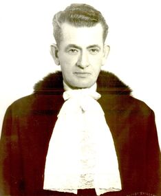
Photograph, Ryan, Samuel John Mayor of Borough of Port Fairy 1958
Remembered for the time Mayor Ryan challenged the local Member of Parliament Mr. George Gibbs to an elephant race down the length of Sackville Street . The race attracted extensive publicity. In a close finish the Mayor of Port Fairy was declared the winner. Black & white portrait of Samuel Ryan in Mayoral robes, jabot and gold chainmayor, portrait, government, shire, council, municipal, local government -
 Port Fairy Historical Society Museum and Archives
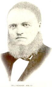
Photograph, Cr J Meagher Shire of Belfast president 1876-77
He was chairman when the ill fated fire occurred at the Shire Office in Sackville Street, and which later led to the conviction of the Engineer, Mr D.J.Howes who was soon after reprieved, upon a potion by 758 ratepayers and residents of the district.Black and white portraitbelfast, meagher, president, portrait, government, shire, municipal, local-government, howes -
 Port Fairy Historical Society Museum and Archives
Photograph
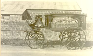
Guyett and Sons builders, and Undertakers occupied a shop in Sackville Street Port Fairy now owned by Brooke's. The property runs through to Princes Street more commonly known as 'Coffin Alley' because the buildings a t the back were used by the undertaking part of the business.Black and white photographtransport, rail, road, guyetts undertakers, buildeers, sackville street, hearse, wagon -
![Escol Estate [Kew], 1940](/media/collectors/550653872162f11fb04854aa/items/59115843d0ce2b1f048f0fbb/item-media/591158fdd0ce2e1f04f1e0f5/item-fit-380x285.jpg) Kew Historical Society Inc
Kew Historical Society IncPlan - Subdivision Plan, Escol Estate [Kew], 1940
Pru Sanderson, in her groundbreaking ‘City of Kew Urban Conservation Study : Volume 2 - Development History’ (1988), summarised the periods of urban development and subdivisions of land in Kew. The periods that she identified included 1845-1880, 1880-1893, 1893-1921, 1921-1933, 1933-1943, and Post-War Development. These periods were selected as they represented periods of rapid growth or decline in urban development. An obvious starting point for Sanderson’s groupings involved population growth and the associated economic cycles. These cycles also highlighted urban expansion onto land that was predominantly rural, although in other cases it represented the decline and breakup of large estates. A number of the plans in the Kew Historical Society’s collection can also be found in other collections, such as those of the State Library of Victoria and the Boroondara Library Service. A number are however unique to the collection.The Kew Historical Society collection includes almost 100 subdivision plans pertaining to suburbs of the City of Melbourne. Most of these are of Kew, Kew East or Studley Park, although a smaller number are plans of Camberwell, Deepdene, Balwyn and Hawthorn. It is believed that the majority of the plans were gifted to the Society by persons connected with the real estate firm - J. R. Mathers and McMillan, 136 Cotham Road, Kew. The Plans in the collection are rarely in pristine form, being working plans on which the agent would write notes and record lots sold and the prices of these. The subdivision plans are historically significant examples of the growth of urban Melbourne from the beginning of the 20th Century up until the 1980s. A number of the plans are double-sided and often include a photograph on the reverse. A number of the latter are by noted photographers such as J.E. Barnes.The ‘Escol Estate’ was a subdivision, which created Bramley Court, which runs south from Sackville Street between Evans Road and Orford Avenue. The subdivision was comprised of 12 lots. At the auction of the lots in May 1940, eight of the 12 allotments were sold. The land was sold subject to a restriction of only one private residence being erected on each lot.subdivision plans - kew, sackville street – kew (vic.), bramley court – kew (vic.) -
 Kew Historical Society Inc
Footwear - Pair of Boy's Leather Shoes, c.1920
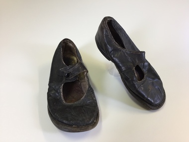
This pair of shoes were the first shoes of Robert Lyndhurst Piesse [the donor's father], born at ‘Tarrangower’ 39 Broadway, Camberwell 24 May 1917. The family moved to ‘Merridale’ 43 Sackville Street, Kew in 1922. The shoes were kept as a treasured item belonging to her father by his daughter. Pair of toddler's brown leather shoes done up with a single loop and button. Leather soles and uppers. The sole has a small leather heel. footwear - children's, boys' shoes, merridale, robert lyndhurst piesse, piesse family -
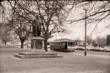
 Ballarat Tramway Museum
Photograph - Black & White Photograph/s - set of 3, Charles Craig, Aug. 1971
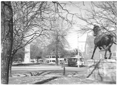
Yields information about the intersection of Lyons St and Sturt St and statues in the median strip.Set of three Black and White photographs of trams near the intersection of Sturt St and Lyons St. .1 - Single trucker outbound, Lyons St, with the Golden City Hotel and St Patrick's Cathedral in the view, along with the Cenotaph and the Adam Lindsay Gordon Statue of a Horse (1969) (See reference for city of Ballarat document) .2 - 43 - with St Patrick's Cathedral. .3 - 30 (determined from a high res scan), with the Town Hall and the Cenotaph in the background. Photo by Charles Craig August 1971. See http://www.ballarat.vic.gov.au/media/499947/sturt%20street%20gardens%20calm%20plan.pdf - accessed 2-2-2017. trams, tramways, sturt st, statues, town hall, st patricks, lyons st, tram 43, tram 30 -
 Melbourne Legacy
Document - Document, notes, Re. Hostel
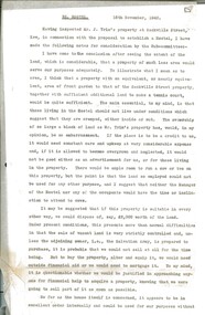
Legatee Russell's assessment dated 16 November 1942 of a property owned by a Mr J. Trim at Sackville Street, Kew, in connection with the proposal to establish a Hostel. His main concern was that the property had too much land attached, and he discusses possible solutions before concluding that an alternative property with less land would be preferable.A record to the types of properties available at the time in relation to the needs of prospective children.Two typed foolscap sheets, carbon copies, two punched holes for filing.Signed by Legatee Eric Russell, Chairman Hostel Committee.residences, holmbush -
 Warrnambool and District Historical Society Inc.
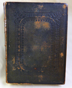
Book - The Holy Bible, Late 19th Century
A King James version of the Bible presented to the Allansford Congregation in 1881 by J H Atkinson who was a chemist from 1848 to 1876 on the corner of Sackville and Bank Streets Port Fairy . In January 1878 he opened a pharmacy in partnership with Warrell in the Apothecaries Hall in Timor Street. Rev. Swinburn was an assistant at St Paul’s Church in 1880.St Paul’s Church, Allansford opened in 1882 and this donation would have been one of the earliest donations to the congregation.Olive green/ brown leather cover with imprinted rectangular pattern on front and back covers. Spine has Holy Bible in gold lettering. It has dark blue ribbon page marker and gold on edges of pages.Presented to the Church of England Allansford by J.H Atkinson, Warrnambool, September 1881. Also letter from Mr Atkinson to Rev. Swinburn.allansford, st paul's allansford, j h atkinson, rev swinburn, bible, 1881 -
 Port Fairy Historical Society Museum and Archives
Postcard - Photograph, Seacombe House Port Fairy
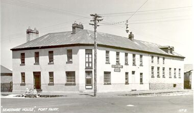
Seacombe House Formerly named The Stag Cnr Sackville and Cox Streets Port Fairy John Sanders (Saunders) first came to Port Fairy in charge of the "Sally Ann" owned by the Henty family of Portland. He left the sea behind in 1844 and established the "Sally Ann Inn" named for his old ship, on the site of the present day Star of the West hotel. After selling the Sally Ann Inn to John Taylor he acquired the land on the South west corner of Sackville Street and erected a detached cottage facing Sackville Street for which he obtained a licence to sell alcohol and named the premises The Stag Inn. He died in 1850 and his wife leased the Inn to John Mason. By 1852 a large two story rendered bluestone building had been constructed on the corner site. The second un rendered section was probably added in 1854. Abijah John Brown became licencee in 1855 and made the Stag the centre of entertainment for the district, with many balls, dinners and concerts taking place there. It boasted "a billiard room and a twenty stall stables and coach house". By 1861 Abijah Brown had left The Stag and Lennox Trew was now owner and licencee. It came up for sale in 1869 but failed to sell. After Trew's death in 1886 it was sold to a syndicate and opened as a boarding school. It later became a Coffee Palace and Accomodation house named Seacombe House, and in the 1950's a motel was built on the old stable site. It is still a Hotel Motel and a restaurant which has revived the old name of "The Stag". Black and white Photograph of 2 story rendered building with multi paned windows and power pole on cornerhotel, lennox trew, abijah brown, john sanders, john saunders, john mason., sackville street, cox street, stag inn, stag hotel, seacombe house, coffee palace -
 Melbourne Tram Museum
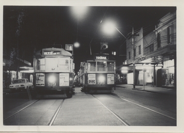
Photograph - Black & White Photograph/s, Chris Phillips, Sep. 1969
Black and white photograph, taken during the night, of W5's 819 and 775 stored with many other tramcars in Glenferrie Road, looking northwards during the reconstruction of the Malvern Tram Depot lead, 13/9/1969. Taken by Chris Phillips, printed on Kodak Paper. Tram 819 has drivers panel advertisement for Hilti, Hollins Austin Morris cars and 775 for Hollins Austin Morris cars and Sackville.On the rear in black ink "13/9/69"trams, tramways, mmtb, malvern depot, glenferrie rd, trackwork, tram 816 -
 Melbourne Tram Museum
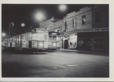
Photograph - Black & White Photograph/s, Chris Phillips, Sep. 1969
Black and white photograph, taken during the night, of W5's 819 and 775 stored with many other tramcars in Glenferrie Road, looking northwards during the reconstruction of the Malvern Tram Depot lead, 13/9/1969. Taken by Chris Phillips, printed on Kodak Paper. Tram 819 has drivers panel advertisement for Hilti, Hollins Austin Morris cars and 775 for Hollins Austin Morris cars and Sackville. Also in the background is the Salvation Army shop.On the rear in black ink "13/9/69"trams, tramways, mmtb, malvern depot, glenferrie rd, trackwork, tram 816 -
 Port Fairy Historical Society Museum and Archives
Photograph
In 1858 Hugh Wallace , undertaker and cabinet maker, moved from the Assembly Rooms at the corner of Gipps street, and opened his new Bank Hotel in Sackville street, next door to the grand Bank of Australasia. The hotel seems to have been the favourite meeting place for many of the sporting organisations of the time , including the Football, Rowing, Athletic and Gymnastics clubs . The second licensee was Thomas Pearson, who came to Belfast in 1855, working first for the Harbour master Capt. John Mills , then as the first Assistant Lighthouse keeper when it was built in 1859 . He was promoted to Lighthouse keeper 2 years later. The hotel continued in business with a further 8 licensees until it closed in 1918. Since which it has housed a diverse number of businesses, collecting a veranda along the way. It is still in use in Sackville street today. Quite a few of the Licensees of Belfast seem to have also had an interest in the Funeral business. Possibly, it was a good commercial undertaking, the same people providing them with a living selling spirituous liquor, and when they died of the effects , paid again for their burial. Early photograph Black and white photograph of Black and white photograph of double storied rendered detached building with doors at either end and two arched windows and door in centrehotel, building, sackville street, bank hotel, inn, business, commercial -
 Port Fairy Historical Society Museum and Archives
Photograph
In 1858 Hugh Wallace , undertaker and cabinet maker, moved from the Assembly Rooms at the corner of Gipps street, and opened his new Bank Hotel in Sackville street, next door to the grand Bank of Australasia. The hotel seems to have been the favourite meeting place for many of the sporting organisations of the time , including the Football, Rowing, Athletic and Gymnastics clubs . The second licensee was Thomas Pearson, who came to Belfast in 1855, working first for the Harbour master Capt. John Mills , then as the first Assistant Lighthouse keeper when it was built in 1859 . He was promoted to Lighthouse keeper 2 years later. The hotel continued in business with a further 8 licensees until it closed in 1918. Since which it has housed a diverse number of businesses, collecting a veranda along the way. It is still in use in Sackville street today. Quite a few of the Licensees of Belfast seem to have also had an interest in the Funeral business. Possibly, it was a good commercial undertaking, the same people providing them with a living selling spirituous liquor, and when they died of the effects , paid again for their burial. Image of a hotel that no longer exists in this formBlack and white photograph of Two story hotel with multi panel window two men and a boy posing on footpathhotel, building, hugh wallace, bank of australasia, thomas pearson, sackville street -
 Kew Historical Society Inc
Map, MMBW, MMBW Plan No.66 Kew, 1900-1910
The Melbourne and Metropolitan Board of Works (MMBW) was established by an act of the Victorian Parliament in 1890 to prepare for and to implement a sewerage and water reticulation system across what was then inner Melbourne, its surrounding and middle distance suburbs, including Kew. The MMBW was disbanded in 1991.The map collection of the Kew Historical Society has at its core the historic maps assembled and originally stored in the City Engineer's Department of the City of Kew. These include maps in a number of scales. The vast majority of maps were produced by the MMBW in the first two decades of the twentieth century, and are solid working maps, backed by linen for durability. These maps are historically significant to Kew, the City of Boroondara and to the history of the development of state utilities in Victoria. A number of the Kew maps have additional details added by former municipal officers, including the levels reached by various floods. As these were working documents, information was added to them long after the period of their initial production and distribution.Early map of part of the Borough of Kew, created in the first decade of the twentieth century, at a scale 160 ft to 1 inch. The map covers what was then the south eastern part of Kew, bordered on its north by Adeney Avenue, in the west by Sackville Street, in the south by Barkers Road, and in the east by Burke Road. The map shows the extent of urban development by that time, prominent institutions and the outlines of built structures in the municipality. Contour lines were added in ink to the map at a later stage.MELBOURNE AND METROPOLITAN BOARD OF WORKS / PLAN NO. 66 / KEW melbourne & metropolitan board of works, mmbw maps, mmbw plans, borough of kew, cartography -
 Kew Historical Society Inc
Plan, Melbourne & Metropolitan Board of Works : Borough of Kew : Detail Plan No.1565, 1905
The Melbourne and Metropolitan Board of Works (MMBW) plans were produced from the 1890s to the 1950s. They were crucial to the design and development of Melbourne's sewerage and drainage system. The plans, at a scale of 40 feet to 1 inch (1:480), provide a detailed historical record of Melbourne streetscapes and environmental features. Each plan covers one or two street blocks (roughly six streets), showing details of buildings, including garden layouts and ownership boundaries, and features such as laneways, drains, bridges, parks, municipal boundaries and other prominent landmarks as they existed at the time each plan was produced. (Source: State Library of Victoria). This plan forms part of a large group of MMBW plans and maps that was donated to the Society by the Mr Poulter, City Engineer of the City of Kew in 1989. Within this collection, thirty-five hand-coloured plans, backed with linen, are of statewide significance as they include annotations that provide details of construction materials used in buildings in the first decade of the 20th century as well as additional information about land ownership and usage. The copies in the Public Record Office Victoria and the State Library of Victoria are monochrome versions which do not denote building materials so that the maps in this collection are invaluable and unique tools for researchers and heritage consultants. A number of the plans are not held in the collection of the State Library of Victoria so they have the additional attribute of rarity.Original survey plan, issued by the MMBW to a contractor with responsibility for constructing sewers in the area identified on the plan within the Borough of Kew. The plan was at some stage hand-coloured, possibly by the contractor, but more likely by officers working in the Engineering Department of the Borough and later Town, then City of Kew. The hand-coloured sections of buildings on the plan were used to denote masonry or brick constructions (pink), weatherboard constructions (yellow), and public buildings (grey). MMBW Plan No.1565 is an example of a plan where a number of streets have been created since the area was surveyed, or in other cases renamed. The plan shows those streets that were bordered by Ross Street, Mount Street, Sackville Street and Burke Road. Since 1905, Mawson Street has been created and Mont Albert Road renamed as Dean Street. Named houses on the plan include ‘Tyrol’, ‘Glengorse’, ‘Theodore Villa’, ‘Arncliffe’, ‘Ballynira’ and ‘Hazeldene’. The plan also shows a Wesleyan Church in Sackville Street. In 1883, the Church’s Sunday School celebrated its silver anniversary.melbourne and metropolitan board of works, detail plans, mmbw 1565, cartography -
 Ballarat Tramway Museum
Negative - Set of 5, Campbell Duncan, 10/08/1971 12:00:00 AM
Yields information about tram operations and the street views in Sturt St near Lyons St.Set of 5 photographs taken on 10/8/1971 by Campbell Duncan of trams in Sturt St near Lyons St. .1 - No. 27 inbound with a Twin Lakes and destination of Mt Pleasant, passing the Peter Lalor statue in the median strip. .2 - No. 34 outbound crossing Dawson St with the Golden City Hotel in the background. .3 - No. 21 outbound with St Patrick's Cathedral in the background and the Adam Lindsay Gordon statue (1969) memorial to the horses killed in the First World War. 4. ditto .5 - No. 13 inbound with a Twin Lakes sign and destination of Victoria St, crossing Lyons St, with St Andrews Kirk in the background. For notes on the statues see: http://www.ballarat.vic.gov.au/media/499947/sturt%20street%20gardens%20calm%20plan.pdf (accessed 11/12/16)trams, tramways, sturt st, dawson st, lyons st, statues, tram 27 tram 34 tram 21 -
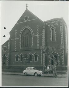 Uniting Church Archives - Synod of Victoria
Photograph, undated
The Gipps Street Wesleyan Methodist Church of 1874 and the adjoining school hall, were built in the Collingwood Flat area - one of the municipality's poorest areas. In 1903, the Collingwood Methodist Mission was established with its headquarters in the Gipps Street Church. Six Methodist Missions were created in inner Melbourne. Three churches were operated by the Collingwood Mission. They were: Sackville Street Collingwood, Elizabeth Street, North Richmond (demolished), and Gipps Street Collingwood (demolished). The Mission operated until approximately 1930.B & W exterior view of the Gipps St. Collingwood Methodist Church. The image is a street view of a group of children and an adult standing in front of the brick church.gipps st. methodist church, les gorrie, collingwood mission -
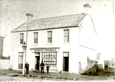
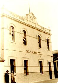 Port Fairy Historical Society Museum and Archives
Photograph
Tennysons Hotel Sackville Street Port Fairy Patrick Tennyson leased the Farmers Inn in 1882 and applied to change the name to Tennysons Hotel. In 1885 he bought the freehold in the Great Land Sale for 780.12.8 (Pounds, shillings and pence) and then carried out extensive renovations. This double storied addition was added in 1893. The hotel continued under various licensees until it burned down in 1977 under the name "Fishermen's Arms". This photograph was taken during the licencee W J WrightBlack and white photograph of facade of two story building hotel, sackville street, port fairy, tennysons, fishermens arms, farmers inn, w.j.wright -
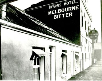 Port Fairy Historical Society Museum and Archives
Photograph
Tennysons Hotel Sackville Street Port Fairy Patrick Tennyson leased the Farmers Inn in 1882 and applied to change the name to Tennysons Hotel. In 1885 he bought the freehold in the Great Land Sale for 780 pounds.12 shillings and 8 pence and then carried out extensive renovations. The double storied addition was added in 1893. The hotel continued under various licensees until it burned down in 1977 under the name "Fishermen's Arms". This photograph was taken during the licencee W J Wright; the single story was the Farmers InnBlack and white photograph of facade of Hearn’s hotel with two advertising signs for beerhotel, sackville street, tennysons hotel, farmers inn, fishermen’s arms, inn, w.j.wright, patrick tennyson -
 Kew Historical Society Inc
Plan - Subdivision Plan, St Helliers Estate, Kew, circa 1910, c.1910
Pru Sanderson, in her groundbreaking ‘City of Kew Urban Conservation Study : Volume 2 - Development History’ (1988), summarised the periods of urban development and subdivisions of land in Kew. The periods that she identified included 1845-1880, 1880-1893, 1893-1921, 1921-1933, 1933-1943, and Post-War Development. These periods were selected as they represented periods of rapid growth or decline in urban development. An obvious starting point for Sanderson’s groupings involved population growth and the associated economic cycles. These cycles also highlighted urban expansion onto land that was predominantly rural, although in other cases it represented the decline and breakup of large estates. A number of the plans in the Kew Historical Society’s collection can also be found in other collections, such as those of the State Library of Victoria and the Boroondara Library Service. A number are however unique to the collection.Subdivision plans are historically important documents used as evidence of the growth of suburbs in Australia. They frequently provide information about when the land was sold on which a built structure was subsequently constructed as well as evidence relating to surveyors and real estate and financial agents. The numerous subdivision plans in the Kew Historical Society's collection represent working documents, ranging from the initial sketches made in planning a subdivision to printed plans on which auctioneers or agents listed the prices for which individual lots were sold. In a number of cases, the reverse of a subdivision plan in the collection includes a photograph of a house that was also for sale by the agent. These photographs provide significant heritage information relating house design and decoration, fencing and household gardens.In the subdivision of part of Crown Portion 82, bordered by John and Sackville Streets and Cotham and Burke Roads, over 100 lots were offered for sale. In addition to the designated lots, a number of key locations are also identified. These include the Genazzano Convent to the north of Cotham Road, the Reservoir, St Hilary’s and the land holding of Colonel Parnell on the corner of John Street and Cotham Road. On the Plan, No. 5064, is the handwritten name ‘St. Hellier’s Estate’. St. Helliers, the home of the Dumaresq family is shown beside St. Hilary’s.subdivision plans - kew, st helliers estate -
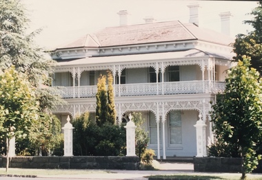 Kew Historical Society Inc
Photograph - 'Berrington', 29 Sackville Street, Kew, 1988
'Berrington' in Sackville Street was built in 1888 for Job Smith, builder, who was the first owner of this substantial two-storey house. The property was given an initial N.A. V. of £125 3 and it is possible that Smith was the contractor for his house.By the turn of the century 'Berrington' was identified as having thirteen rooms and an N.A.V. of £13 while the house remained in the hands of the Smith family until the late 1930s. The new owner at that stage was a Mrs Pederson who convened the house into three flats 6 while in 1951 it was further subdivided to become seven units. (Kew Conservation Study, 1988)Colour photographic positive of one of 'Berrington'. The building is a large two storeyed house typical of the late Victorian period. It remains substantially intact with a cast iron verandah dominating the front and side facades, that has the added distinction of a fine cast iron frieze that at ground floor level has two tiers. Behind the verandah, the facade is asymmetrical. There is a central six panelled door with a fine semicircular fanlight, and segmentally arched windows to the ground floor and on one side of the door there is a polygonal bay window that extends up the two floors. The eaves and chimneys are decorated with Italianate brackets. (Kew Conservation Study, 1988)berrington -- sackville street -- kew (vic.), job smith -
 Kew Historical Society Inc
Plan, Melbourne & Metropolitan Board of Works : Borough of Kew : Detail Plan No.1564, 1905
The Melbourne and Metropolitan Board of Works (MMBW) plans were produced from the 1890s to the 1950s. They were crucial to the design and development of Melbourne's sewerage and drainage system. The plans, at a scale of 40 feet to 1 inch (1:480), provide a detailed historical record of Melbourne streetscapes and environmental features. Each plan covers one or two street blocks (roughly six streets), showing details of buildings, including garden layouts and ownership boundaries, and features such as laneways, drains, bridges, parks, municipal boundaries and other prominent landmarks as they existed at the time each plan was produced. (Source: State Library of Victoria)This plan forms part of a large group of MMBW plans and maps that was donated to the Society by the Mr Poulter, City Engineer of the City of Kew in 1989. Within this collection, thirty-five hand-coloured plans, backed with linen, are of statewide significance as they include annotations that provide details of construction materials used in buildings in the first decade of the 20th century as well as additional information about land ownership and usage. The copies in the Public Record Office Victoria and the State Library of Victoria are monochrome versions which do not denote building materials so that the maps in this collection are invaluable and unique tools for researchers and heritage consultants. A number of the plans are not held in the collection of the State Library of Victoria so they have the additional attribute of rarity.Original survey plan, issued by the MMBW to a contractor with responsibility for constructing sewers in the area identified on the plan within the Borough of Kew. The plan was at some stage hand-coloured, possibly by the contractor, but more likely by officers working in the Engineering Department of the Borough and later Town, then City of Kew. The hand-coloured sections of buildings on the plan were used to denote masonry or brick constructions (pink), weatherboard constructions (yellow), and public buildings (grey). In 1905, when Plan No.1564 was printed, that part of Kew bordered by Brougham Place (now Daniell Place), Mount Street, Sackville Street and Ross Street was already the location of a number of large mansions. Here, subdivisions, at least at this stage, produced larger blocks than in Central Kew. Many of the houses on this plan are named: ‘Faybrook’, ‘Northumbria’, ‘Parkholm[e]’, ‘Dunboe’, ‘Katoomba’ and ‘Eschol’ fronting Sackville Street. Eschol was once the home of the manufacturer Robert Harrison, whose cordial factory in Spring and Argyle Streets Fitzroy are noted on the Victorian Heritage Register. ‘The Hawthorns’ on the corner of Brougham Place and Mount Street was the home of the medical practitioner Frank William Fay, who won the military cross and other honours for conspicuous gallantry and devotion to duty in World War 1.melbourne and metropolitan board of works, detail plans, mmbw 1564, cartography -
Kew Historical Society Inc
Archive (Sub-series) - Subject File, Kew Historical Society, Gardens (Kew), 1979
Various partiesReference, Research, InformationSecondary Values (KHS Imposed Order)Correspondence and newspaper articles/clippings relating to historic gardens in Kew. The oldest item is a letter from the National Trust Victoria announcing their two-year garden study and seeking information on gardens in Kew. Mavis Rolley, Secretary of the Society, made handwritten notes in response, which are kept in the file. She refers to: the pear trees planted by William Oswin in c. 1845 near what is now the Burke Road Bridge (she notes that a search for the trees at the time of the construction of the Eastern Freeway was unsuccessful), a camellia planted by the Dannocks near the corner of Derby and High Street, a c.1876 pine tree in Field Place, Henty Court, an 1875 Moreton Bay fig at Tarring, Ruyton, a Moreton Bay fig at Roxeth, Trinity Grammar, an 1840s oak tree and a 120-year old olive tree at Fairholme, Barry Street, 1870 pine trees at D’Estaville, Barry Street, trees at Turinville, Barnard Grove, dating to 1846, pine trees dating from 1845-6 on the Willsmere Farm, red gums in Victoria Park, pine trees in the Cemetery dating from the 1860s, trees in the Alexandra Gardens and at Kew Primary School, palm trees at La Verna, Sackville Street dating from the 1890s, the trees and gardens at Ross House (Charleville), and the trees at Merridale, Sackville Street which date from the 1880s, a magnolia at Lalla Rookh. These dates are probably highly contestable. Other handwritten notes from 1979 about significant gardens included: 5 Molesworth Street, Red Bluff - Redmond Street (garden now destroyed), Campion House, Studley Park Road, Raheen, Studley Park Road, Ross House, Cotham Road (Charleville), 7 Adeney Avenue, 20-21 Belmont Avenue, 52 Mary Street, an Edna Walling garden on the corner of Argyle Road and Victor Avenue, Merridale, Sackville Street, Roseneath, and Reno, St John’s Parade.gardens - private - kew (vic), garden design - kew (vic), kew horticultural societygardens - private - kew (vic), garden design - kew (vic), kew horticultural society -
 Kew Historical Society Inc
Plan, Melbourne & Metropolitan Board of Works : Borough of Kew : Detail Plan No.1568, 1905
The Melbourne and Metropolitan Board of Works (MMBW) plans were produced from the 1890s to the 1950s. They were crucial to the design and development of Melbourne's sewerage and drainage system. The plans, at a scale of 40 feet to 1 inch (1:480), provide a detailed historical record of Melbourne streetscapes and environmental features. Each plan covers one or two street blocks (roughly six streets), showing details of buildings, including garden layouts and ownership boundaries, and features such as laneways, drains, bridges, parks, municipal boundaries and other prominent landmarks as they existed at the time each plan was produced. (Source: State Library of Victoria)This plan forms part of a large group of MMBW plans and maps that was donated to the Society by the Mr Poulter, City Engineer of the City of Kew in 1989. Within this collection, thirty-five hand-coloured plans, backed with linen, are of statewide significance as they include annotations that provide details of construction materials used in buildings in the first decade of the 20th century as well as additional information about land ownership and usage. The copies in the Public Record Office Victoria and the State Library of Victoria are monochrome versions which do not denote building materials so that the maps in this collection are invaluable and unique tools for researchers and heritage consultants. A number of the plans are not held in the collection of the State Library of Victoria so they have the additional attribute of rarity.Original survey plan, issued by the MMBW to a contractor with responsibility for constructing sewers in the area identified on the plan within the Borough of Kew. The plan was at some stage hand-coloured, possibly by the contractor, but more likely by officers working in the Engineering Department of the Borough and later Town, then City of Kew. The hand-coloured sections of buildings on the plan were used to denote masonry or brick constructions (pink), weatherboard constructions (yellow), and public buildings (grey). Plan No.1568 covers the area bounded by Cotham Road, John Street, Sackville Street, and Edward Street. Alfred Street and Rowland Street are in shown in the middle of the plan. The two most notable buildings shown are ‘St Helliers’, the home of the Dumaresq family, and St Hilary’s Church and school. While the colours used to indicate St Hilary’s are grey as in other civic/public buildings, the first St Hilary’s Anglican Church was at this stage constructed in weatherboard. At the left of the plan, facing Sackville Street is a house named ‘Glencara’. The 1988 ‘Kew Conservation Study’ recorded that “The first documentary evidence of this house comes from Rate Books which record that in 1893 a Mrs Treadway was the owner of this building with an N.A.V. of £81? At that date the occupier of the house was Charles B. Kelly, a clerk, while by 1910 Kelly had become the owner of the property described in that year ‘as a six-roomed stone, brick and wood house with stables and outbuildings’”. Contrary to this description, the 1905 plan indicates that the house was entirely constructed of masonry.melbourne and metropolitan board of works, detail plans, mmbw 1568 -
Kew Historical Society Inc
Archive (Sub-series) - Subject File, Electoral Rolls (Kew), 1958
City of KewReference, Research, InformationSecondary Values (KHS Imposed Order)Subject file (and the library) containing original copies of voter and or electoral rolls. These include, in date order: 1971 - City of Kew Voters Roll for College Ward, 1972 - City of Kew Voters Roll for Central Ward, College Ward, Prospect Ward, Studley Park Ward, 1977 - Victorian Government Electoral Rolls for the Subdivisions of Kew and Kew North, 1986-7 - City of Kew Voters Roll for Central Ward, College Ward, North Ward, Studley Park Ward, 1990-1 - City of Kew Voters Roll for Prospect Ward (2), Sackville Ward, Studley Park Ward (2), Willsmere Ward (2), 1992-3 - City of Kew Voters Roll for Studley Park Ward.kew (vic) - history, kew (vic) - politics, city of kew - electoral rollskew (vic) - history, kew (vic) - politics, city of kew - electoral rolls -
 Kew Historical Society Inc
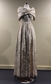
Clothing - Formal Silk Brocade Gown, 1953
The donor's aunt, Margaret E. Hollis nee Piesse (18/2/1919-2008) wore this gown to the Coronation of Queen Elizabeth II in 1953. She was one of a total of 8,251 guests who attended the ceremony at Westminster Abbey, London. Margaret Piesse was born in Hobart and grew up in the Piesse family home, 'Merridale', Sackville Street, Kew. She was residing at 4a Little Cloister, Westminster Abbey at the time of the Coronation and was married (on 14/2/1942) to Rev Howard Hollis, a minor Canon at the Abbey and a deputy Priest in – Ordinary to the Queen (1954-1959). Howard chanted the litany and carried the sceptre. Margaret’s daughter-in-law, Sue Hollis, Margaret’s sons, Julian who attended the Coronation with his mother, and Richard, gave the photograph to Felicity Renowden, the donor. Margaret Hollis died in Kew on 16/4/2008.Single piece, formal silk brocade gown worn to the Coronation of Elizabeth II on 2 June 1953. The bodice is informally draped with horizontal folds of fabric above an antebellum waistline below which is a full skirt. An accompanying photograph of the wearer in the dress can be viewed in the final image above. coronation elizabeth ii, piesse family, merridale -- sackville street -- kew (vic.), margaret e hollis, margaret ellen piesse, fashion design, fashion -- 1950s, women's clothing -- 1950s -
 Kew Historical Society Inc
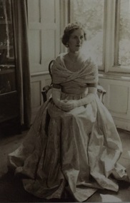
Photograph - Margaret E Hollis, 1953
The donor's aunt, Margaret E. Hollis nee Piesse (18/2/1919-2008) wore this gown to the Coronation of Queen Elizabeth II in 1953. She was one of a total of 8,251 guests who attended the ceremony at Westminster Abbey, London. Margaret Piesse was born in Hobart and grew up in the Piesse family home, 'Merridale', Sackville Street, Kew. She was residing at 4a Little Cloister, Westminster Abbey at the time of the Coronation and was married (on 14/2/1942) to Rev Howard Hollis, a minor Canon at the Abbey and a deputy Priest in – Ordinary to the Queen (1954-1959). Howard chanted the litany and carried the sceptre. Margaret’s daughter-in-law, Sue Hollis, Margaret’s sons, Julian who attended the Coronation with his mother, and Richard, gave the photograph to Felicity Renowden, the donor. Margaret Hollis died in Kew on 16/4/2008. Print copy of an original photograph of Margaret Ellen Hollis (nee Piesse) before she attended the Coronation of Elizabeth II in 1953. She is posed in the photograph, seated wearing her dress, tiara and long elbow length gloves.coronation of elizabeth ii, westminster abbey, piesse family, merridale -- sackville street kew (vic.), margaret e hollis