Showing 302 items
matching the proclaimers
-
 Bayside Gallery - Bayside City Council Art & Heritage Collection
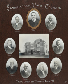
Photograph - gelatin silver photograph, Talma & Co, Sandringham Town Council, Proclaimed 9th day of April,1919, 1919
Sandringham was originally part of the Shire of Moorabbin. On 28 February 1917, Sandringham was severed from Moorabbin and incorporated as the Borough of Sandringham. It was proclaimed a Town on 9 April 1919 and a City on 21 March 1923. The Sandringham Town Hall, located on Abbott Street, Sandringham (formerly the mechanics institute) was demolished in 1994.councillor, sandringham, local government, municipality, mayor, portrait, city of sandringham, sandringham town hall, abbott street, cr. e.l. belyea, cr. b. champion, cr. h.b. grace, cr. c.a. hartsman, cr. j.e.d. beck, cr. b.j. ferdinado, cr. t.g. farrant, cr. w.t.c. kelly, cr. g.w. knott, town, proclamation, bayside, hampton, black rock -
 Bayside Gallery - Bayside City Council Art & Heritage Collection
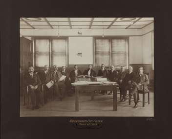
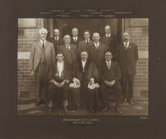
Photograph - gelatin silver photograph, Sarony & Co, The first meeting of the City of Sandringham Council, 21st March, 1923, 1923
Photograph taken on the day that the Town of Sandringham became a City, and the first meeting of the City of Sandringham Council. Sandringham was originally part of the Shire of Moorabbin. On 28 February 1917, Sandringham was severed from Moorabbin and incorporated as the Borough of Sandringham. It was proclaimed a Town on 9 April 1919 and a City on 21 March 1923.councillor, sandringham, local government, municipality, mayor, cr. c.a. hartsman, cr. t.g. farrant, cr. g.w. knott, cr. f.n. gibbs, h.t. williams, town clerk, engineer, cr. j.t.d. beck, b.r. sunderland, cr. w.h. kay, cr. r. chisholm, cr. h.b. grace, cr. j.m. ramsay, city, proclamation, council meeting, city of sandringham -
 Bendigo Historical Society Inc.
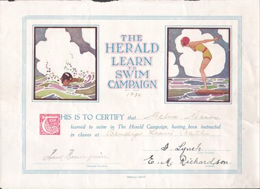
Certificate - The Herald Learn to Swim Campaign, 09/09/2023
Historic swim certificate issued 1934. Bendigo Ladies Baths were proclaimed in the Bendigo Advertiser which stated that ladies could begin to bathe at the City Baths each Wednesday and Saturday from 12 noon to 5 pm as from the 30th Jan 1901. Of course no men were allowed at these times.Herald Learn to Swim Campaign certificate, 1934; on glossed paper. Awarded to Melva Mason at classes held at the Bendigo Ladies Baths.herald learn to swim campaign certificate, coloured swim certificate, bendigo ladies baths -
 Port Fairy Historical Society Museum and Archives
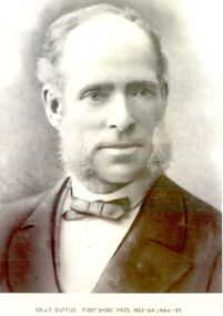
Photograph, Cr JF Duffus 1st Shire of Belfast President 1863-1865
James migrated from Scotland and was elected as a member of the Belfast Road Board in October 1857 and continued in office as Chairman of the Board until 1863 when the Shire was proclaimed. He was accordingly the first Belfast Shire President for 2 year. Cr Duffus was the original owner of the property Known as “Naringashern” (not sure of the spelling)Black and white portrait belfast, president, portrait, government, shire, municipal, local-government, belfast district road board, narigashern -
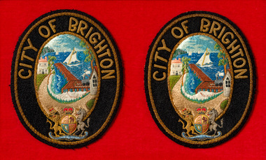 Bayside Gallery - Bayside City Council Art & Heritage Collection
Ceremonial object - Badge, City of Brighton Mayoral robe badges
This pair of embroidered badges were worn on the sleeves of the red City of Brighton mayoral robes until Coat of Arms were granted in 1970 by the British College of Heraldry. Brighton was first incorporated as a borough on 18 January 1859, it became a town on 18 March 1887 and was proclaimed a city on 12 March 1919.Two oval shaped City of Brighton mayoral robe badges, embroidered and mounted on red felt. The badges have a black border with CITY OF BRIGHTON embroidered on the top and the British Coat of Arms on the bottom. The centre image depicts the City of Brighton seal of the Brighton coastline with a pier extending to the water, sail boats in the distance, a train on the right of the pier, and buildings on the left and right sides. coat of arms, mayoral robe badges, badge, mayoral robe, city of brighton, ceremonial wear, mayoral regalia, bayside, crest, british coat of arms, brighton, seal -
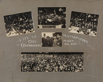 Bayside Gallery - Bayside City Council Art & Heritage Collection
Photograph - sepia photograph, Edwin G. Adamson, City of Sandringham Celebrations, 21st March 1923, 1923
On 21 March 1923, in the presence of 10,000 people, on the City Beach Oval, Sandringham was declared a City by the Earl of Stradbroke. Sandringham was originally part of the Shire of Moorabbin. On 28 February 1917, Sandringham was severed from Moorabbin and incorporated as the Borough of Sandringham. It was proclaimed a Town on 9 April 1919 and a City on 21 March 1923.councillor, sandringham, local government, municipality, mayor, city, proclamation, city of sandringham, lord stradbroke, lady stradbroke, mr. angelo bertotto, city beach oval, crowd, earl of stradbroke, governor, bayside, cr jpd beck, beach oval -
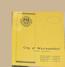 Warrnambool and District Historical Society Inc.
Book, City of Warrnambool
This booklet printed for the Warrnambool Promotion and Development Board in the 1960's showcases the city. It includes brief summaries and black and white photographs of major industries and benefits of the city. Warrnambool was proclaimed a municipality on 7th December 1855, a borough on 1st December 1863, a town on 2 February 1883 and a city on 8th April 1918.This booklet gives a brief overview of the development of the city in the 1960's. This is a 16 page stapled booklet printed in blank ink on glossy paper with black and white photos. The cover is yellow card with a Warrnambool City logo printed in black ink on the top left and the words City of Warrnambool Victoria Australia in the lower third and milestone proclamation dates. The inside facing page has an aerial black and white photograph of the city with a mauve banner at the lower edge.In a mauve rectangle on half of the upper edge is printed in black ink "Warrnambool where Australian Hospitality is a reality" The front cover and inside facing page have oval green ink stamp "Warrnambool North Technical School Library"city of warrnambool, warrnambool promotion and development board -
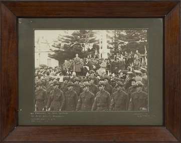 Warrnambool and District Historical Society Inc.
Photograph - Framed Photograph of the Proclamation of Warrnambool as a City, Arthur Jordan, 1918
This is a framed photograph showing a key event in Warrnambool's history - the proclamation by Sir Arthur Stanley of Warrnambool as a city in 1918. Warrnambool was the fifth non--metropolitan town in Victoria to be declared a city and a large crowd gathered outside the Town Hall to see this event. Sir Arthur Stanley (Lord Stanley of Alderley) was an English nobleman, Parliamentarian and soldier who was the Governor of Victoria from 1914 to 1920. The photographer was Arthur Jordan who, like his father Joseph, was a prominent photographer in Warrnambool at the end of the 19th and the beginning of the 20th centuries and took many official photographs of civic affairs. The donor of the photograph, probably immediately after the event to the Warrnambool Museum at the time under the auspices of the Warnambool Mechanics' Institute, was George Mackay, a prominent Warrnambool lawyer, Councillor and Mayor. He was probably responsible for the framing of the photograph.This is a significant photograph as it is a record of an important event in Warrnambool's history and is a great research toolThis is a black and white photograph in a polished wooden frame with a card inset and a glass covering. The photograph shows the Governor of Victoria, Sir Arthur Stanley, in civilian dress standing on a platform outside the Warrnambool Town Hall proclaiming Warrnambool a city. Behind the Governor on the platform are many men and some women and in the foreground left is a band and in the foreground centre are Army school cadets. The photograph frame has a wooden backing with a piece of wire attached for hanging the object. In the photograph also is a columm with a sign on it.His Excellency the State Governor Sir Arthur Stanley Proclamation- Warrnambool a City 23rd May 1918 Warrnambool Museum & Art Gallery Presented by G.S.Mackay Warrnambool Arthur Jordanwarrnambool -a city in 1918, sir arthur stanley, george s. mackay, arthur jordan -
 Bayside Gallery - Bayside City Council Art & Heritage Collection
Photograph - gelatin silver photograph, Sarony & Co, The Councillors and Officers of the first City of Sandringham Council, 1923
This photograph records the Councillors and officers on the day that the Town of Sandringham became a City, and the first meeting of the City of Sandringham Council was held. Sandringham was originally part of the Shire of Moorabbin. On 28 February 1917, Sandringham was severed from Moorabbin and incorporated as the Borough of Sandringham. It was proclaimed a Town on 9 April 1919 and a City on 21 March 1923. city of sandringham, councillors, local government, municipality, mayor, cr. h.b. grace, cr. w.h. kay, cr. j.m. ramsay, cr. f.n. gibbs, cr. g.w. knott, cr. r. chisholm, t.g. farrant, cr. c.a. hartsmann, m.h.t. williams, town clerk, cr. j.t.d. beck, m.w.t. sanderland, surveyor -
 Warrnambool and District Historical Society Inc.
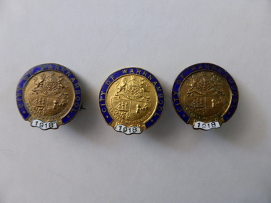
Badge, medallion, City of Warrnambool 1918, 1918
From its beginnings in the late 1840's, Warrnambool progressed through the years from being a town and borough to finally being proclaimed a city in May 1918. The Governor of the day Mr Arthur Stanley officiated at the event on May 23rd, 1918. It was only the fourth such municipality to achieve this status at the time These medallions were a memento of this occasion.These small medals are significant as they are linked to an important event in the growth of Warrnambool. Three similar medallions in the form of a brooch with clasp, all in gilt metal and enamel. Round medallions 25mm in circumference, with blue enamel circular rim of 4mm around most of the outside, except for white enamel decal of 10mm at bottom. Pin clasp on reverse of the medallions. Two medallions donated from a separate source are identical with the others in markings; one with pin clip, one without pin clip. All medals identical, though manufacturers imprint " Bridgland & King " only appears on reverse of two. "City of Warrnambool" appears in gold block letters around blue enamel circumference of medal, "1918" appears in gold lettering in white enamel decal at the bottom. Warrnambool city crest is pressed in gold relief in the centre of the medal, consisting of a ship at sea, a sheaf of wheat, these quartered below the Victorian Coat of Arms. Beneath the crest the words, "By These We Flourish" are inscribed. city of warrnambool, proclamation of city of warrnambool -
 Mission to Seafarers Victoria
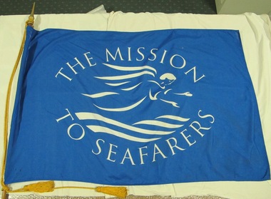
Flag, The Mission to Seafarers, 21st Century
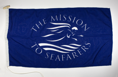
Flag displaying the flying angel motif. The highly stylised motif gives a clue as to approx date of manufacture. The Mission adopted, as its symbol, a flying angel inspired by a verse from the Book of Revelation (14:60) “Then I saw a flying angel in mid-heaven, with an eternal gospel to proclaim to those on earth, to every nation and tribe, language and people”.From the personal Collection of Mrs Pat Dann a former member of the Central MtSV and later with her husband Captain Keith Dann supported and founded the Hastings branch of the Mission to Seamen in the late 20th C. Large rectangular Mid-blue polyester fabric Mission to Seafarers (with flying angel motif in white) flag, with synthetic mounting rope.flag, flying angel -
 St Kilda Historical Society
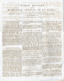
Document - Annual report, First Report by the Municipal Council of St Kilda, 1857
First report of the Municipal Council of St Kilda, for the half-year from 11 March 1857 - 11 September 1857. The Municipal District of St Kilda was proclaimed on 24 April 1855 but the election of the Council was delayed by a dispute over boundaries. This report outlines the process of deciding on the boundaries and establishing the Council, which met for the first time on 11 March 1957.Four-page report, printed double sided on two sheets of folded blue bank papermunicipality of st kilda, st kilda - history, 19th century -
 Ringwood and District Historical Society
Picture, Peter Payens, Wooden framed board holding sepia coloured photos of Ringwood City Councillors inscribed "Proclaimed a City ... 1960", 1960
Prepared by Peter Payens, Ringwood. Hung in Council ChambersWooden framed board holding sepia coloured photos of Ringwood City Councillors inscribed "Proclaimed a City ... 1960". +Additional Keywords: Hubbard, B.J. - Councillor JP / Spencer, R.O. - Councillor JP / Baxter, D.J. - Councillor / Deuter, M.D. - Councillor / Lavis, A.G. - Councillor JP / McLeod, L.H. - Councillor / Hodgkins, J.F. - Councillor / Horman, R.C. - Councillor JP / Vergers, P. - Councillor JP / Dwerryhouse, F.P. - AIMA, JP, Town Clerk / Robertson, A.C. - C.E., AIME, City Engineer -
Warrnambool and District Historical Society Inc.
Document - The Ruskin All-about Warrnambool 1955, Ruskin Publishing Pty Ltd, 1955
Warrnambool was created as a municipality on 7th December 1855, declared a Borough on 1st October 1863, proclaimed a Town on 2nd February 1883, and a City on 8th April 1955. This 1955 edition of the Ruskin "All-about" covers the facilities and activities of the Municipality of Warrnambool. It provides a directory for residents with maps, bylaws, transport times, schools and societies and a classified listing of professions, trades, shops and factories.This directory provides a significant synopsis of the City of Warrnambool in 1955/1956.This is 28 page paper booklet with a blue cover and white front cover with an illustration of a TAA female pilot in the bottom right hand corner with white, blue, red and black printing. There is a 16 page insert which includes a 1956 calendar, agricultural information and the 1956 Melbourne Olympic Games official programme. The rear cover has a colour advertisement of two petrol pumps and Energol oil products with a male attendant.The Ruskin All-about WARRNAMBOOL TAA serves the nation Fly TAA -the friendly waywarrnambool, warrnambool trade directory, ruskin all-about, 1956 olympics -
 Bendigo Historical Society Inc.
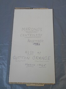
Newspaper - Lydia Chancellor collection: Marong and Sutton Grange centenaries
The Marong PO opened 1/1/1860 and the area was declared the Marong Road District 19/8/1860. On 12/12/1864 it was redesignated as the Marong Shire and then in 1990 it was proclaimed a rural city. The Sutton Grange PO opened 1/8/1865 and closed in 1970. The Sutton Grange School operated from 1970-1988 and the Uniting Church opened in 1874.Manilla folder titled: Marong's centenary November 1964, also of Sutton Grange March 1965. Inside several newspaper clippings from the Bendigo Advertiser relating to the two events.marong, sutton grange, centenary -
 Whitehorse Historical Society Inc.
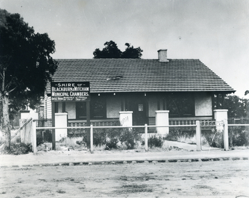
Photograph - B/W Photograph, Municipal Chambers - Shire of Blackburn & Mitcham - First Office
When the Shire of Blackburn and Mitcham was proclaimed on 27th May 1925, the second meeting of the Shire was held in the hall of the Methodist Church on Monday 28th September 1925 at 7.30pm.|Three ensuing meetings were also held there and following meetings were at the dwelling in Whitehorse Road, which was purchased by the Shire for use as their office. (By Coincidence this dwelling was almost on the site of their new Municipal Offices.)Black and white picture - Municipal Chambers of Shire of Blackburn & Mitcham located opposite the present offices of City of Whitehorse in Whitehorse Road, Nunawading|See also NP35 & NP36 after it was destroyed by fire.municipal chambers - first office, shire of blackburn and mitcham, whitehorse road, nunawading, methodist church -
 Mission to Seafarers Victoria
Flag - Flying Angel Mission to Seafarers Flag, Early 21st century
Founded in 1856, the Mission adopted, as its symbol, a flying angel inspired by a verse from the Book of Revelation (14:60) “Then I saw a flying angel in mid-heaven, with an eternal gospel to proclaim to those on earth, to every nation and tribe, language and people” The mission to Seamen became the Mission to Seafarers at turn of the 20th to 21st century. A new logo and graphic of the Angel of the revelation was produced.The change from seamen to seafarers recognised that many seafarers are not exclusively male. Cooks, spouses, cadets, officers have increasingly come from a broader range of gender.Commissioned blue flag with Mission to Seafarers insignia. Mounted on long wooden pole with pointed ferrule at end, corded artificial silk with two tassels. 'MISSION TO SEAFARERS'flag, missions to seafarers, blue, ferrule, tassels, wood, pole -
 Nhill Aviation Heritage Centre
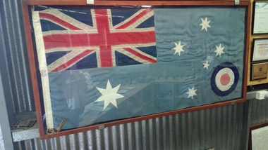
Memorabilia - RAAF ensign 1948 -1982
Prior to 1948 the RAAF used the British RAF flag . In December 1948 King George V1 proclaimed the new, uniquely Australian design to be used by the RAAF. It featured a smaller roundel with a slightly tilted southern cross and 7 pointer star, similar to the Australian Flag, on a sky blue background. This ensign was used until 1982 when the red dot in the roundelwas replaced by the image of a kangaroo. This flag was stored in the Nhill RSL Australian flag with sky blue background, with roundel in bottom RH corner. -
 Bendigo Historical Society Inc.
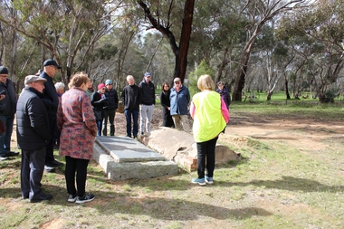
Bendigo Historical Society Walking Tour of Axedale, 1st Sept 2024
Axedale is a town in Victoria, Australia. It is located on the McIvor Highway, in the City of Greater Bendigo, east of Bendigo. It was surveyed and proclaimed in 1861. At the 2021 census, Axedale had a population of 984. The town is nestled alongside the Campaspe River which feeds out of Lake Eppalock. It has a golf course, tennis courts, a school, a pub and a convenience store/petrol station. It lies between Heathcote and Bendigo.Forty Photos taken on the walking tour of Axedale by the Bendigo Historical society. Places visited included the Protestant and Catholic Cemeteries, the "Blue Stone House", the 150-year-old bridge over the Axe Creek on the Sugerloaf Road, the old Cobb and Co Stables, St Andrews Church and the Campaspe River Bridge.axedale, bendigo historical society walking tour, st andrews church axedale, axedale cemetery, axe creek bridge, campaspe, cobb and co stables axedale, blue stone house axedale -
 Glenelg Shire Council Cultural Collection
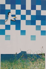
Print - Print - Lawrence Rocks and Point Danger from Crumpets, Paula Tsernjavski, Lawrence Rocks and Point Danger from Crumpets, 1985
Gannet in flight over seascape. Blue and white checks form an abstract background in a little over half the top area of image.Front: 7/25 (lower left, pencil) Lawrence Rocks and Point Danger from Crumpets (lower centre, pencil) Mayor of Portland (lower left, blue stamp) Back: Portland Proclaimed a City October 28th 1985 (lower centre, blue stamp) Minister for Local Government (lower right, blue stamp) -
 Orbost & District Historical Society
black and white photograph, Vogt, Stanley, 1910 - 1920
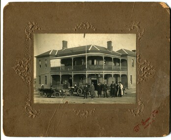
In 1884 J.A. Petterson built the first Orbost Club Hotel with the licence in the name of Thomas Maguire (his stepson). This hotel was the first in the area and cost 1,400 pounds to build (ref. In Times Gone By - Deborah Hall) and was actually built before Orbost was proclaimed a township - April 17 1885. T.a. Marshall was the proprietor about the time the photograph was taken. This is the bottom pub in Orbost known as the Club Hotel.The Orbost Club Hotel was the first hotel built in the Orbost district and was an important hub for the township with many whole town meetings held there.A black / white photograph on a brown buff card with embossed decorations. It is of the Orbost Club Hotel, a large two-storeyed building with verandahs on both levels. In the foreground are two motor vehicles and a group of men dressed in suits, hats and overcoats facing the camera.on back - "Mrs Mustard"orbost-club-hotel -
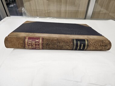
 City of Kingston
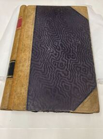
Book - Rates Cash Book, Rates Cash Book Moorabbin Shire, 1919, 1916
Councils use property values to calculate how much each property owner pays in rates. This can give us some insight to property values within the municipalities. Receipts have been recorded by Receipt No, Date, Name and Riding. The subdivisions at that time which were proclaimed by Order-in-Council on 22nd May 1917, were North Riding, Moorabbin Riding, Cheltenham Riding, and South Riding.Brown suede and Black linen bound book with Rates Cash Book Moorabbin Shire in gold text along the spinePrinted on white rectangular sticker in black ink: ARNALL & JACKSON/ Engravers and Lithographers/ PRINTERS/ and/ MANUFACTURING STATIONERS/ 478 Collins Street/ MELBOURNE/ No.B 27676 / 1/8/19rates, ridings, moorabbin, municipality -
 City of Kingston
Book - Rates Cash Book, Rates Cash Book Moorabbin Shire, c.1918
Councils use property values to calculate how much each property owner pays in rates. This can give us some insight to property values within the municipalities. Receipts have been recorded by Receipt No, Date, Name and Riding. The subdivisions at that time which which were proclaimed by Order-in-Council on 22nd May 1917, were North Riding, Moorabbin Riding, Cheltenham Riding, and South Riding.Brown suede and Black linen bound book with Rates Cash Book Moorabbin Shire in gold text along the spinePrinted on white rectangular sticker in black ink: ARNALL & JACKSON/ Engravers and Lithographers/ PRINTERS/ and/ MANUFACTURING STATIONERS/ 478 Collins Street/ MELBOURNE/ No.B 33325 / 2/10/18 rates, ridings, moorabbin, municipality -
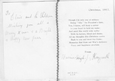 Geelong RSL Sub Branch
Christmas Card, 1917
This card was sent to his sister Elsie by 9028 Joseph Haygarth, Farrier Sgt. 9028 Farrier Sgt Haygarth enlisted on 15 July 1915 setrved with DAC 2nd Division and returned to Australia in 1919.This card was Christrmas Card was sent by 9028 Farrier Sgt J Haygarth to his sister Elsie and her children for Christmas 1917.An oblong card with a paper insert. Thed two pieces are held together with purple cotton thread.On the card front - two flags, the Union Jack and a Red Ensign. On the paper insert - Christmas 1917, a poem "Though I'm only one of millions...Peace and happiness proclaim. From Farrier Sgt J Haygarth. 2nd DAC AIF. To Elsie and the Children, wishing you all a Merry Xmas and a bright and Happy New Year. -
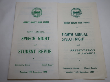 Kiewa Valley Historical Society
Mt Beauty High School Speech Night 1971 and 1972
Mount Beauty High School was proclaimed in 1963 with 213 pupils, 12 staff members. The enrolments and staff numbers increased as the Kiewa Hydro Electric Scheme continued to be constructed . 1. The Annual Report gives details re Accommodation, Grounds & Buildings, Equipment, Curriculum, Activities, Advisory Council, Cafeteria, Staff and Thanks. 2. In 1972, 27 teachers (names & subjects) are listed as well as other staff. The Reports are similar to that in 1970Mt Beauty High School grew quickly and then declined in numbers as the Kiewa Hydro Electric Scheme was constructed from the late 1940s to the 1960s. It is currently (2023) still operating serving the population in the Kiewa Valley. 1.Pale yellow paper folded x2 opening up to 3 columns of green print. 12 items listed followed by 'Extracts from the Eighth Annual Report. The Report contiues on the back. Front page has logo, title & date 14th Dec. 1970 2. Booklet of 12 pages (6 paper sheets)14 items on page 2, Staff listed on page 3, Principal's Report on page 4- 6. S.R.C. Report page 7, 10th Annual Report page 8-9,President's Report page 10. Scholarships & Awards page 11-12. Front page has logo and title. Tenth Annual Speech Night and Student Revue 12th December 1972 mt beauty high school, speech night programmes 1970 1972 -
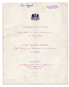 St Kilda Historical Society
Ephemera - Special event program, In Celebration of the Opening of the Parliament of the Commonwealth of Australia, 1901
Program for the first opening of Parliament after Federation. Prince George Frederick Ernest Albert (1865–1936), Duke of Cornwall and York was the second son of Edward VII and Queen Alexandra. The visit was part of an Empire tour and a tribute to the response made throughout the Empire during the Boer War. On their return to Britain the couple were proclaimed Prince and Princess of Wales and, on the death of Edward VII in 1910, became George V and Queen Mary.White coloured folded program, printed in purpleFront page/cover: UK Coat of Arms In Celebration of the Opening of the Parliament of the Commonwealth of Australia. To meet their Royal Highnesses The Duke and Duchess of Cornwall and York. Reception by His Majesty's Ministers of State for Australia, at the Exhibition Building, Melbourne, on the 9th May, 1901. Middle pages: Programme (items listed) Back page/cover: Refreshments Will be Served all the Evening on the Ground Floor and in the Galleries 1901, opening of parliament, duke and duchess of cornwall and york, royal visits -
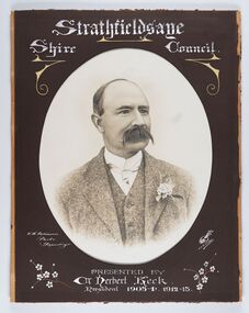 City of Greater Bendigo - Civic Collection
Photograph - Portrait of Councillor Keck, W H Robinson, c 1913
The district of Strathfieldsaye was proclaimed in 1861 and named a Shire on the 17th September in 1866. It remained a shire until amalgamation in 1994 when it became part of the City of Greater Bendigo. The shire was located 8 km to the south- east of Bendigo and covered an area of 601 square kilometres and extended from the Calder Highway to the Coliban and Campaspe Rivers. The shire's administration centre was in Strathfieldsaye until 1972 when new offices were opened in Kennington.Framed black and white head and shoulder portrait of Councillor Keck with hand coloured and drawn detail. Profile slightly to right with walrus moustache. Cut oval brown mount decorated with text and flowers. Hand written title top and lower centre.Strathfieldsaye / Shire Council / W.H. Robinson / Photo / Bendigo / J.H.E Gribbs / Presented by / Cr Herbert Keck / President 1903-4. 1912-13.shire of strathfieldsaye, councillor keck, strathfieldsaye shire council, president of strathfieldsaye shire -
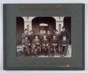 City of Greater Bendigo - Civic Collection
Photograph - Councillor group portrait, W H Robinson, Strathfieldsaye Shire Council, 1909
The district of Strathfieldsaye was proclaimed in 1861 and named a Shire on the 17th September in 1866. It remained a shire until amalgamation in 1994 when it became part of the City of Greater Bendigo. The shire was located 8 km to the south- east of Bendigo and covered an area of 601 square kilometres and extended from the Calder Highway to the Coliban and Campaspe Rivers. The shire's administration centre was in Strathfieldsaye until 1972 when new offices were opened in Kennington.Photographic group portrait of eleven Strathfieldsaye Shire Councillors in front of the Strathfieldsaye Shire Hall. Five men are seated and six standing with one man standing further in back ground on the building's verandah. Photograph is attached directly to green mount card and framed. Gold lettering on mount.Strathfieldsaye Shire Councillors / R. B. Brennan (Sec.) W. J. Lowdes S. Doak M. Burns () N Condon B. Code (Inspector) / WH Robinson Photo Bendigo / T Somerville / W. I. Long / Fred Osborne (President) H Keck / W Dresler / With the President's (Cr. Fred Osborne) Compliments / September 23rd, 1909shire of strathfieldsaye, strathfieldsaye shire council, president of strathfieldsaye shire, strathfieldsaye shire hall -
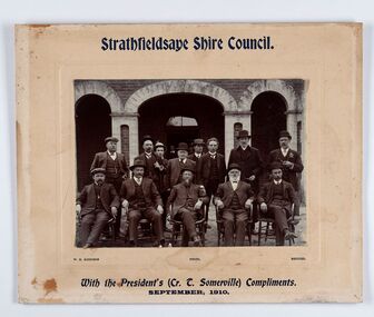 City of Greater Bendigo - Civic Collection
Photograph - Councillor group portrait, W H Robinson, Strathfieldsaye Shire Council
The district of Strathfieldsaye was proclaimed in 1861 and named a Shire on the 17th September in 1866. It remained a shire until amalgamation in 1994 when it became part of the City of Greater Bendigo. The shire was located 8 km to the south- east of Bendigo and covered an area of 601 square kilometres and extended from the Calder Highway to the Coliban and Campaspe Rivers. The shire's administration centre was in Strathfieldsaye until 1972 when new offices were opened in Kennington. Group portrait of 13 men / councilors, 5 seated and 8 standing dressed in suits. There are another 2 men further back in front of the hall doors. Photograph is taken outside the Strathfieldsaye Shire Hall.Srathfieldsaye Shire Council. / With the President's (Cr T. Somerville) Compliments. / September, 1910 / W.H. Robinson Photo. Bendigo Verso; William Drechslershire of strathfieldsaye, president of strathfieldsaye shire, strathfieldsaye shire council -
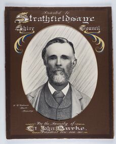 City of Greater Bendigo - Civic Collection
Photograph - Portrait of Councillor Burke
The district of Strathfieldsaye was proclaimed in 1861 and named a Shire on the 17th September in 1866. It remained a shire until amalgamation in 1994 when it became part of the City of Greater Bendigo. The shire was located 8 km to the south- east of Bendigo and covered an area of 601 square kilometres and extended from the Calder Highway to the Coliban and Campaspe Rivers. The shire's administration centre was in Strathfieldsaye until 1972 when new offices were opened in Kennington. Framed black and white head and shoulder portrait of Councillor Burke with hand coloured and drawn detail. Profile centre facing with beard. Cut oval brown mount decorated with text and fscrolls. Hand written title top and lower centre. Wooden frame with detail and gold inner.Presented to Strathfieldsaye / shire Council / w. H. robinson / Photo / Bendigo / By the family of / Cr John Burke / President 1890 - 1899 - 1900strathfieldsaye shire council, councillor burke, president of strathfieldsaye shire