Showing 122 items
matching victorian bushfires
-
 Federation University Historical Collection
Document, Zelda Martin, Central Victorian Goldmining towns - Boom Towns or Ghost Towns?, c1996
Zelda Martin was a PhD candidate at the University of Melbourne.[.1] 4th item in light blue display book titled Research Approach/Overview of Chapters/Confirmation of Canditure/Chapters1,2,3&4 of proposed thesis. *Twenty-seven page article on Victorian goldfields towns titled: Central Victorian Goldmining Towns - Boom Towns or Ghost Towns. The article was written during the author's PhD study. It outlines the context methodology, and resources and the chapters of the proposed thesis: (1) Central Victorian Goldmining Towns - The Context (2) Contemporary Views of the Factors Necessary for Town Growth (3) Outward Manifestations of Town Growth (4) The Trappings of Government (5-9) The Main Towns and Their Hinterland. [.2] 5th item in Light Blue display book as above item. *Chapter 1 of proposed thesis titled 'Pick, Shovel and Tin Dish Mining.' Covers in Section A: Central Victoria - Pre 1851: Aborigines in Central Victoria, Squatters, and Government. Section B: The years 1851-1854: The Early Gold Rushes, Government Reaction, Township Surveys, Legislation, Town Development, Local Government and Early Settlement. [.3] 6th item in Light Blue display book as above item. *2A of proposed thesis titled 'Contemporary Views of the Factors Necessary for Town Growth'. Similar information to Chapter 1 plus extra re towns and maps. Sections: Introduction, Context of Place - Geographical Towns Listed, The Context of Time - Pre1851 Aborigines, Governance of Port Phillip, The Squatters, The Villages of Central Victorian Highlands, Conclusion, Condensed Version of Chapter2B. [.4] 7th item in Light Blue display book as above item. *Chapter2B of proposed thesis. Sections: Area of Research, Schools, Banks, Newspapers, Progress Association, Town Development - Sandhurst (Bendigo), Ballarat, Castlemaine,, Maryborough, Ararat and Stawell. [.5] 8th item in Light Blue display book as above item. *Chapter 3 of proposed thesis titled 'Outward Manifestations of Town Growth'. Sections: Introduction, Contemporary Writing, Educationalists, The Bankers, The Townsfolk, Current Theory, General Theories of Urban Development, and Conclusion. [.6] 9th item in Light Blue display book as above item. *Chapter 4 of proposed thesis titled 'Trappings of Government' Sections: Introduction, Early Government Attitudes to Mining and Town Development, Law and Order, Township Surveys, Legislation, Local Government, Transport and Communication, The People and Lobbyists. [.7] 10th item in Light Blue display book as above item. *'The Rise and Fall of Central Victorian Goldmining Towns'. Includes a map showing main Goldfields, a table showing towns and villages at two points in time - 1857 and 1871; a Bibliography of Primary and Secondary Sources. [.8] Resource No1. Black display book titled Local Towns 1 : Alma: *Brief history *Directory *Maps Amphitheatre / Mountain Hut: *Brief History Post Office Directory Ararat: *Brief History *Post Office Directory 1869 - Alphabetical Listing by Occupation *Ararat - Prominent Citizens of 1858 *Langi-Morgala Museum Avoca: *Brief History *Excerpts from 'Avoca The Early Years', Margery and Betty Beavis; pg1 - Beginnings; pg11 - The Midas Touch; pg25 - Local Gold Escorts; pg27 - A Town is Born; pg51- The Administration of Justice; pg53 - The Ways of the Law; pg61 - News of the Day; pg65 - A Time to Play; pg72 - Land Ownership *Post Office Directory (Bailliere's) 1869 *Tourism Map and Information of area *Historic Avoca - A 5.5km Tour *Avoca & the Pyrenees Region - information pamphlet Ballarat: *Early History of Ballarat - Ballarat Historical Society, Publication No.1: origin of the name; Ballaarat - the Beginning; Fabulous Yields from the Ballaarat Goldfield; *Streetscape Lydiard Street. *Hand drawn map showing Leigh River, Old Portland Bay Road, plaque on road to Colac; etc. *Newspaper article re 'The Theatre Royal' ( which stood in the vicinity of the current Owen Williams store) - 'The News'15/04/1998 *Article - 'Ballarat's Mechanics' Institute Lives On' Ballarat Courier, 14/09/1985 *Article - Standing the Test of Time' The News 17/11/1993 re The Mechanics Institute & picture of the Reading Room *'Ballarat a Study of a City, Phyllis Reichl, pub. Nelson, 1968; no.3 place, time and people field studies series *Investigator Vol.33 No.2, 1998 Geelong Historical Society. Article on pg75 describes Ballarat in 1861 *Folded poster - 'Ballarat 100' a history of telegraph communication, pub. Telecom. Beaufort (Fiery Creek): *Brief history *Post Office Directory [.9] Resource No.2 Black Folder Titled Towns cont.No2 Bendigo (Sandhurst): *'Family & Local History at the Bendigo Library - 1851-2001 150 years of gold'. *Bendigo Government Camp in 1853 illustration; key to sketch and names of Government officers stationed there *Excerpts from 'Bendigo and Vicinity' Adolph Haman *The Bendigo Goldfield Registry - pgs 1-7 Introduction *Excerpt: 'Breaking the Grip' *Excerpt: The Most Go-Ahead Place *Excerpts from 'History of Bendigo' - anti license agitation; laying out of town; proposed railway; gold calls and dividends; the Sandhurst Municipality; journalism *Bibliography Blackwood: *Excerpts from 'Aspects of Early Blackwood - The Goldfield, the Landmarks, the Pioneers' Alan J Buckingham and Margaret F Hitchcock, JG Publishing,1980 Buninyong: *A Brief History *Investigator Vol1 No.2 Feb 1966 Geelong Historical Society. Pg3 - Article re gold escort route - Mt Alexander to Adelaide - (see a simple monument on the Western Highway a few miles out of Horsham. Pg 15 - Ballarat Excursion - re the finding of gold. *Three articles published by Buninyong and District Historical Society Inc: (Magpie Exploration; Finding Gold In The Green Hills; Magpie Exploration; Burnt Bridge to Cargarie to Mt Mercer) *Copies of newspaper articles/items *Buninyong Street Directory Carisbrook: *In the Beginning There Was Carisbrook *The History of the Carisbrook Racecourse Carngham / Snake Valley: *Brief History *Directory Castlemaine: *Directory 1865-1866 - Alphabetical and Street *Poster - Castlemaine A Contemporary Guide "The Great Centre" 1866 - A Contemporary Guide to the Fascinating Past *Pamphlet - Castlemaine District Community Hospital *Map - Castlemaine, Maldon & Surrounding Districts *Map and Information - The Dry Diggings Track - a 55kl walk among historic goldfields relics ( Castlemaine Fryerstown Vaughan Mt Franklin Hepburn Daylesford) *Postcard - Former Court House *Directory 1867 - Alphabetical, Trade [.10] Resource No.3 Grey folder Titled Towns 3 Creswick to Maryborough Creswick: *Brief History *Booklet - "Creswick Cemetery Walk" *Booklet - The Buried Rivers of Gold Heritage Trail Creswick *Creswick Historical Museum Information Sheet *Chronological History of Creswick *Alphabetical Directory of the Borough of Creswick *Creswick's Creek Directory 1856 *Historic Creswick Walking Tour *A Brief Account of the Schools of Creswick - Past and Present *100 Years of Railway Travel in Creswick *The Berry Deep Leads *The Spence Home at Jackass Gully in the Creswick State Forest ( William Guthrie Spence - Pioneer) *The New Australian Mine and the 1882 Disaster *Creswick District News, Issue 7, July August 1999 *The Creswick Miners Walk - Information and Map *Maps Chewton: *Brief History *Directory Clunes: *Brief History *Clunes Street Directory Daylesford: *Brief History *Notable Bushfires in Daylesford District Over More Than a Century - "Black Thursday" 1851; 1862; 1899; the Disastrous Hepburn Fire of 1906; 1939; 1944; 1969. *Post Office Directory -Daylesford and Hepburn Dunolly / Inkerman: *Brief History *Directory *Pamphlet - Goldfields Historical Museum *Pamphlet - Historic Dunolly - Victoria's Best Kept Secret *Map of Gold Workings at Dunolly Area - showing where the main gold rushes occurred *Brief History - Inglewood *Directory - Inglewood - Name Occupation, Dwelling Kingower: *Brief History *Directory - Name / Ocupation / Dwelling Linton / Happy Valley / Piggoreet: *Brief History *Directory - Lintons McIvor: *"A History of the Shire and the Township of Heathcote" by J.O. Randell Majorca: *Brief History *Official Post Office Directory 1869 - Name / Occupation/ Address Maldon (Tarrangower): *Brief History Part 1 *Brief History Part 2 *Post Office Directory *List - Alphabetical Order by Names plus Business and Trade (Tarrangower Times Oct/1858) *List - Alphabetical Order by Trade plus Name and Business *Directory - Name / Occupation / Dwelling Maryborough: *Worsley Cottage - built by Arthur Worsley, a contractor in stonework in 1894 [.11] Resource No. 4 Blue Display Book titled Towns 4 Moliagul to Stawell Moliagul: *Brief History *Moligul Legislative Assembly (Voting?) List - Names and Occupations *Moliagul Victorian Post Office Directory 1868 - Name / Ocupation / Address / Comments *"The Welcome Stranger" gold nugget *The Sunday School *The Welcome Stranger Discovery Walk - information and map Moonambel (Mountain Creek) Redbank *Brief History *List of names extracted from advertisments of the Pioneer and Mountain Creek Advertiser 16/02/1861. *Bailliere's Directory 1869 - Alphabetical List of Name / Occupation / Place St Arnaud: *Brief History Sebastapol: *Brief History *Directory 1869 - Alphabetical by Name; plus occupation and address. Browns and Scarsdale: *Brief History *Browns Street Directory - Name and Occupation Smythesdale: *Brief Description *Smythesdale Street Directory -Name and Occupation Stawell (Pleasant Creek) *Brief History *Victorian Official Post Office Directory - Name /Occupation / Dwelling *Chronology - 1841-1920 *Production of gold statistics - 1879 - 1900 *Big Hill *Extracts from "The Golden Years of Stawell". Chapt 1 - Stawell's Coming Out. Capt. 2 - The Gold Rush. Caapt.3 - Cradle of Democracy. Chapt.4 - The Reefs Becomes Stawell. Chapt. 5 - Rushing In. Chapt.6 - The Pioneers. Chapt 7 - The Decade of Optimism. [.12] Resource No. 5: Blue Display Book titled 'Towns Steiglitz to the The Golden Triangle. Steiglitz: Brief History Victorian Post Office Directory 1869 *Map of Steiglitz *List of maps relevant to Steiglitz history *Information 6 tables of data from "Reports of Mining Surveyors Talbot (Back Creek) Brief History Taradale: Post office Directory 1869 - Name/Occupation/Street. Also list in alphabetical order by Occupation Taradale *Chronological Reference to Taradale Mines *Water - The Coliban System of Waterworks *Joseph Brady *The Syphon Tarnagulla (Sandy Creek) *Brief History *Tarnagulla Businessmen Cameos to give depth to advertisments in 'The Tarnagulla Courier' various issues 1864-1871 *Directory - Name/Occupation /Address *List - Name/Business/Trade Wedderburn (Koorong) *Brief History *List - Name/Occupation The Golden Triangle: *The Early Rushes - Wedderburn / Moliagul / Sandy Creek - Tarnagulla / Jones Creek - Waanyarra / Kingower / Dunolly - Goldsborough / Inglweood *Census of 1857 - Population / Occupations *1858-1871 - A Time of Consolidation- Wedderburn / Moliagul / Sandy Creek- Tarnagulla / Arnold *Census 1871 - Population *Information gleaned from the census data - Demographics / Population / Occupations / marital / Birthplace / Religion / Literacy/ Occupation and Housing Cameos *Graphs - Birthplace of settlers /Male-Female Ratio / Married males / Children under 15 as Percentage of Population / Religion *Census 1857 - Statistical data *Maps *Bibliography [.13] Resource No. 6 - Black Display Book Information and Research in Central Victoria including: *Banking - Research from ANZ Bank Archives *Institutions - also includes articles listed from the Ballarat Times Newspaper *Australian mining History Association - A.M.H.A. Bibliography *Australia's Mining History * Bibliography - Land Surveys Victoria - *1853 Administration (Statistics and Other) includes: schools / ministers of religion / police / military / local administration / licences for sale of spirits / distances between various Victorian gold fields. * Victoria Government Gazette (Copy) - N0. 116, 12/12/1854 includes: Gold Felds Commission of Enquiry & No. 85, 15/09/1854 - Addresses presented to the Lieutenant Governor (Sir Charles Hotham) during his tour through the Gold Fields of Victoria,1854. Addresses on behalf of : the people of Bendigo; Members of the Church of England, Bendigo; Members of the Wesleyan Church on the Bendigo Gold Fields; Bendigo Gold District General Hospital; the Bendigo Prospecting Association; Committee of the Bendigo Local Exhibition; Bendigo District Medical Association; Coloured Americans Resident at Bendigo; German Inhabitants of Bendigo; Landowners, Inhabitants, and Miners of Castlemaine; Inhabitants of Forest Creek; Inhabitants of Heathcote and Gold Miners of McIvor; Residents and landholders of the District of Bacchus Marsh; Inhabitants of Kilmore and Vicinity. *Gold Fields Correspondence 1853: letter from Lieutenant Colonel Valiant, (Officer commanding the Troops in Victoria) to the Lieutenant Governor re threatened disturbance at Sandhurst (Bendigo) regarding the Gold License Fee. * Extracts from a book "Victoria" re Gold Fields Commission of Enquiry involving mainly Ballarat and Castlemaine and a chapter titled 'A Tour to the Victorian Gold-Fields' *Lists of central Victorian newspapers - listed by date published 1851to 1874; by first date available to State Library. *A list of cities and towns showing County, population in 1861 &1871, and municipal status. [.14] Resource no.7. Black display book. *Reference: Papers presented to Parliament Victoria - 1859-1860 4 volumes - relevant sections copied. Contains information on Branches of Government. General / Finance / Gold / Gazette / Commission and Warrant / Statistic. *Gold Fields Act. In accordance with the Act the gold fields are divided into six districts - Ballaarat, Castlemaine , Sandhurst, Avoca, Ararat, and Beechworth.. Official staff in each gold district consists of a Resident Warden, Wardens, Wardens' Clerks, Bailiffs, Chinese Protectors, Chinese Interpreters, and Mining Surveyors. *Gold Receiver *Gaols *Police magistrates and Clerks of Petty Sessions, etc. *Field Branch *Immigration and Emigration Overland - Chinese - 1859 *Population on the Goldfields *The Geological Survey - The Government Geologist is assisited by staff from four branches - the office Branch; the Publishing Branch; the Field Branch and the Museum Branch. *Commission to Enquire Into Sludge dated 10/02/1859 (Some sections copied) - Report to the Honorable Chief Commissioner of Public Works, Melbourne re the mode of carrying the sludge from the puddling mills in Sandhurst without interfering with the drainage of the town and the roads in the neighbourhood. [.15] Resource No.8: Camel display book titled Resource No. 8. Aborigines *Lists of book titles - +"Readings in Victorian prehistory" +"The Aborigines of Port Phillip" +Aboriginal languages and clans" +"A History of the Port Phillip District" +"Langi Ghiran 1: Aboriginal Rock...." +"Koorie History: sources for aboriginal studies in the State Library of Victoria", ed. Tom Griffiths, Melb. Friends of the State Library, 1989 +"The Public Lands of Australia Felix"; settlement and land appraisal in Victoria1834-91 with special reference to the Western Plains", J.M.Powell, Melb. Oxford University Press 1970 +*Bibliography of the Victorian Aborigines' from the earliest manuscripts to 31st December 1970, Massoa, Aldo, Melb. Hawthorn Press, 1971 +"Aborigines in Colonial Victoria, 1836-1886", M.F. Christie, Sydney University Press, 1979 +"Urban and Industrial Australia: readings in Human Geography" ed J.M. Powell, Melb. Sorrett Pub. 1974 *Extracts: -Processes of Pioneer Settlement - The Squatting Occupation of Victoria, 1834-60. J.M. Powell -Areal Variations in the Class Structure of the Central-Place Hierarchy. P. Scott - Volume1 and Volume 2: Notes Relating to the Habits of the Natives of Other Parts of Australia and Tasmania. Compiled from various sources for the Government of Victoria by R Brough Smyth. John Curry, O'Neil, Melb. 1st pub. Melb. 1876. p31-45 - Numbers and Distribution of the Aborigines in Victoria -Victorian Aborigines 1835-1901 - A Resource Guide to the Holdings of the Public Record Office, Victoria; published by the Government Information Centre 1984. *History of the Aboriginal Artefacts Displayed in the Daylesford Museum. F. G. Powell (4 page pamphlet) *Letter to Zelda Martin from Peter Lovett, Cultural Officer, Ballarat & District Aboriginal Co- Operative, 05/02/1997 *Map: Ian Clarke Victorian Tribunal Boundary Map - Clans of Central Victoria. *Victorian Rock Art and Mythology - Article about Mount Langhi Ghiran and myths of the Tjapwarong people. *Two Aboriginal myths relating to the Grampians - 'The Monster Emu' / 'The Aquisition of Fire', by the Aborigines in the Grampians Areas *Article titled (chapter 8) Ballarat - information re camping sites in the region. Lake Wendouree / Lake Burrumbeet (includes a myth) / Mt Bunninyong / Lal Lal / Pitfield / Mount Elephant / Mount Egerton / Meredith / Lake Goldsmith / Lake Learmonth / Ercildoune *Notes on the Aborigines of the Wider Ballarat Region plus European names=Aboriginal names. John Morris 26/07/1995 *Role of Aborigines in Town Development in Central Victoria. Mentions Native Police Force est. in Port Phillip 1842 and Central Board for Aborigines est. 1860 *The Grave of King Billy. (Frank Wilson) Pamphlet. *Camping Places in Central and Northern Victoria. Article re Lake Burrumbeet site. *Programme for the Unveiling of Memorial Cairn for Edward Stone Parker 1802-1865. Note portrait not accurate. Accurate portrait is available in the book "A Successful Failure A Trilogy The Aborigines and Early Settlers", Edgar Morrison, Graffiti Publications, 2002. * Large envelope addressed to Mr G Netherway containing newspaper cuttings regarding the life of Edward Stone Parker, the unveiling of the Memorial Cairn as mentioned above, articles titled 'Episodes from Our Early Days' (Edgar Morrison, Yandoit)- The Black's School, A School At Last and The Final years. Also a typed page titled 'Historical Background to E.S.Parker's Career. Includes an interesting tale titled 'When the cat lay doggo' re laying power leads for the unveiling ceremony at the memorial site. [.16] green display folder titled 'Research Aids' *List of references to Commissioners' & W'ardens' Reports (formerly held at La Trobe Library Archives, now at Public Records Office [PRO]). Indicates town referred to / date of report / name of camp if different to town. * Archive information re Anglican Records *Movement around the Goldfields - Miners and Storekeepers - usefulness of newspapers in providing information - areas covered - Castlemaine, Maldon, Ararat, Stawell, Tarnagulla, Dunolly. *Port Phillip /Victoria Directories 1839/1867 - Chronological list of Directories included in this series. *"Notes on the History of Local Government in Victoria" A.W. Greig Melb. University Press 1925 - Photo-copied extract p5-p40. (Source - Deakin University Library) - Introduction by W.Harrison Moore. Section 1 - Development in New South Wales Before Separation. Section 2 - Development in Victoria After Its Separation from New South Wales. Hand written notations: 'roads, markets, and local government 1855 on' ;'opportunity of squatters in parliament' and 'opportunities of matters in parliament p33' * Notes on the Establishment of Surveyor General's Department 1851and Commissioner of Crown Lands and Survey. * Newspaper articles from The Argus, 1849, re the discovery of gold in the Pyrenees region. * Excerpt - a report on schools - A.B.Orlebar, Inspector; re the need for permanent school buildings rather than tents. *Excerpt from - 'Approaches to Urban History', Sean Glynn: The Case for Caution * Except from - 'The Urban Sprinkle', Weston Bate: Country Towns and Australian Regional History *Reference- 'The History of Land Tenure in the Colony of Victoria', John Quick. References the Haines Land Bill, land tenure and Land Leagues. [.17] Light blue envelope folder titled 'Birtchnell's Ballarat, etc. Directory 1862 *Contains various directories for Smythesdale, Buninyong, Clunes, Brown's and Creswick. [.18] Red envelope folder no.2 titled Victorian Gazetteer *Selected pages from 1869 Victorian Gazetteer on A4 paper (with a handwritten note questioning if some pages are from 1868 Victorian Gazetteer as appears to be different sizes - A3 pages.) Information includes locations and descriptions of towns, hotels, banks, communications and populations. (Does not include names, residences and occupations) [.19] Red Envelope folder titled Bailliere's Official Post Office Directory 1868 (or1869 or a mixture of both?) *Preface *Contains a selection of pages of towns highlighted in yellow in the the index *Work on this directory was commenced in 1867. *Information includes: Municipalities - mayors and councilors; lists of towns naming male inhabitants and their occupations. [.20]Yellow manila folder titled Post Grad Seminar Presentation 1996 *Gives some background to Zelda Martin's proposed thesis and why she chose the topic Gold Mining Towns Boom or Bust [.21] A3 display book - No. 1A * A list of 'Relevant Newspapers collected: The Tarrangower Times and Maldon Advertiser (first published 1858) Includes dates 1858-1867. The Mount Alexander Mail. Includes dates 1854-1866 The Tarnagulla Courier. Includes dates from1864-1871 Dunolly and Burnt Creek Express. Includes dates from 1862-1871 * Selection of newspaper pages from The Mount Alexander Mail 1854 to 1856, mostly showing advertisements for businesses and services provided to that community. [.22] A3 display book - No. 1B * Selection of newspaper pages from The Mount Alexander Mail 1857 to 1866, mostly showing advertisements for businesses and services provided to that community. [.23] A3 display book -No. 2 * Selection of newspaper pages from The Tarnagulla Courier 1864 to 1871, mostly showing advertisements for businesses and services provided to that community. [.24] A3 display book - No. 3 *Selection of newspaper pages from The Tarrangower Times (and Maldon and Newstead) Advertiser 1858 to1867, mostly showing advertisements for businesses and services provided to that community. [.25] A3 display book - No.4 * Selection of newspaper pages from The Dunolly and Burnt Creek Express; and The Dunolly and Betbetshire Express 1862 to 1871, mostly showing advertisements for businesses and services provided for that community. [.26] A3 display book - No.5 Includes: * Bryce Ross's Diggings Directory. Includes instructions for using this directory. This directory was used by "all persons having connexion or desiring to communicate with 'working parties, private friends, or Stores at the Diggings." As a directory for each area wwas completed it was published in each month's issue of Bonwick's "Digger's Magazine." Years c1852/1853. This Directory commences first at the head of Forest Creek. Includes a directory for Bendigo and Ballarat. Of interest at the end of the Bendigo and Ballarat directory is a list of the number of storekeepers, butchers, doctors, smiths, eating houses, lemonade sellers and chapels. * The Castlemaine Directory and Book of General Information Comprehending Glass's Model Calendar for the Two Years 1862 and1863. "zelda martin, victorian goldfield towns, bendigo, castlemaine, ballarat, maldon, stawell, ararat, maryborough, creswick, avoca, heathcote, banks, bank of australasia, union bank of australia, government camp, sandhurst, water supply, tarnagulla, talbot, back creek, mountain creek, police court, carisbrook, dunolly, thompson's foundry, charles clacy, anthony trollope, robert cecil, mount alexander, urbanisation, national schools, education, govenrment, industry, railway, transport, settlement, land settlement in central victoria, steiglitz, joseph brady, the new australian mine, berry deep leads, william guthrie spence, creswick state forest, arthur worsley, worsley cottage, the welcome stranger, moliagul, moonambel, redbank, st arnaud, sebastapol, brown's, scarsdale, clunes, chewton, daylesford, bushfires, inkerman, inglewood, kingower, lintons, happy valley, piggoreet, mcivor, majorca, tarrangower, taradale, the coliban system, the syphon, sandy creek, wedderburn, koorong, arnold, jones creek, waanyarra, the golden triangle, census 1857, blackwood, buninyong, durham lead, magpie, carngham, snake valley, alma, amherst, daisy hill, amphitheatre, mountain hut, beaufort, fiery creek, counties, population, gold fields commission of enquiry1854, william westgarth, gold license fee, lieutenant colonel valiant, administration of the victorian gold fields, commission to enquire into sludge 1859, e.s. parker, edward stone parker, edgar morrison, mount franklin protectorate, dja dja wurrung, memorial cairn, franklinford, mt franklin memorial cairn, jajowurrong, dja dja wurung, tjaowarong, wothowurong, assistant protectors, daylesford museum, buluk, rock art - grampians, aboriginal mythology - grampians, aborigines, first nations people, mount franklin, aboriginal artifacts, lake burrumbeet, native police force, central board of aborigines, yandoit, commissioners' reports, wardens' reports, port phillip/victoria directories 1839-1867, local government - victoria 1853/1854, surveyor general's department - 1850's, victorian schools 1850's, a.b.orlebar, haines land bill, william charles haines, wilson gray, land tenure, land leagues, victorian gazetteer, the tarrangower times and maldon advertiser - 1858-1867, the mount alexander mail 1854-1866, the tarnagulla courier 1864, dunolly and burnt creek express 1862-1871, bryce rose's diggings directory, the castlemaine directory 1862-1863 -
 Bendigo Historical Society Inc.
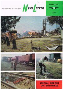
Document - BADHAM COLLECTION: NEWSLETTER FEBRUARY1969 SPECIAL REPORT ON BUSHFIRES
Victorian Railways Newsletter February 1969 Special report on bushfires. Glossy paper with colour photos on front of bushfires in relation to railway property. The contents include photos of effects of the fire to VR property, closure of State coal mines, photos of fire destroyed bridge at Diamond Creek, Molesworth, the Powlett River Coal Field in 1910 (Wonthaggi), and Kirrak Mine. Printed at the Victorian railways printing works Laurens St North Melbourne.magazine, government, victorian railways, victorian railways newsletter / photos of effects of the fire to vr property/ closure of state coal mines / photos of fire destroyed bridge at diamond creek / molesworth/ the powlett river coal field in 1910 ( wonthaggi) / kirrak mine / printed at the victorian railways printing works laurens st north melbourne -
 Victorian Interpretive Projects Inc.
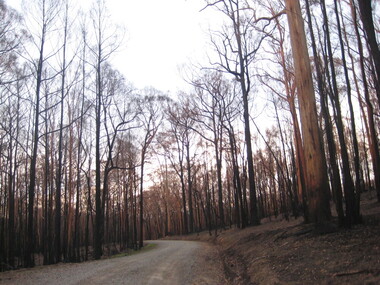
Photograph - Photograph - Colour, Clare Gervasoni, Daylesford Bushscene after the bushfire, 20/05/2009
In 2009 Daylesford was threatened by bushfire. The scene depicted is in the bush around East Street. The fire uncovered evidence of goldfields workings. Many of the towns residents evacuated as the bushfire threat increased, while others watched the fire from the top of Wombat Hill. Colour photograph in digital format showing a bushscene at Daylesford after fire. daylesford, bushfire, fire, mining -
 Victorian Interpretive Projects Inc.
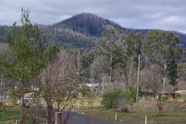
Photograph - Colour, Marysville after Black Saturday
In February 2009 bushfires devastated Marysville, resulting in in nation-wide support enabling a rebuilding programme. A number of colour photographs documenting the remarkable recovery of Marysville after the 2009 Black Saturday Bushfires. Badly burnt trees reshoot, houses are rebuilt, but black scars remain on hillsides where the heat was at its hotest.marysville, bushfire, regrowth -
 Victorian Interpretive Projects Inc.
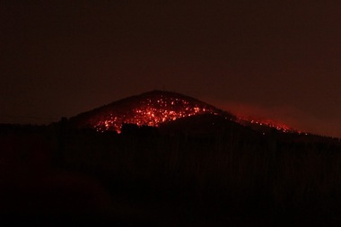
Photograph - Digital, Andrew Matheson, Night View of Fire on Mount Warrenheip, 2013, 15/05/2013
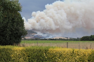
The photographer took these night photos from his home in Bungaree, on close proximity to Mount Warrenheip.A bushfire on Mount Warrenheip, near Ballarat, photographed at night.warrenheip, fire, bushfire, bungaree -
 Victorian Interpretive Projects Inc.
Photograph - Digital, Andrew Matheson, Bushfire on Mount Warrenheip, 2013, 15/05/2013
A bushfire broke out on Mount Warrenheip in May 2013.Eight photographs of Mount Warrenheip, near Ballarat, with clouds of smoke caused by a bushfire. The photos were taken from Bungaree.warrenheip, fire, bushfire, smoke -
 Victorian Interpretive Projects Inc.
Photograph - Digital, Clare Kathleen Gervasoni, St Mary's Kinglake, 2012, 15/12/2012
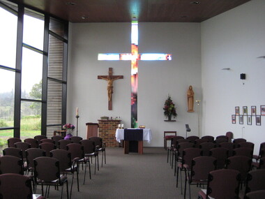
The images depict the newly completed fourth Catholic Church at Kinglake. The previous three churches having been destroyed by 'Black Saturday' bushfire. The painting is oil on canvas. The historical continuity is expressed by the continuity of the skyline and the disconnectedness of the colours. it is not a literal depiction of each church, but a recognizable and symbolic image conveying resilience of faith of the local community. The first church was burnt down in a bushfire, the second burnt down by vandals, and the three burnt down in the 2009 bushfires known as 'Black Saturday'.The white cross and black fence at the lower left commemorated the remarkable fact that these remained intact after the 2009 bushfires. The red-orange can be the colour of the kinglake soil or the fires. The return of new life is indicated by the green growth on the burnt gumtrees. The presence of the Holy Trinity is shown above the entrance to the church. The return of new life is indicated by the green growth on the burnt gumtrees. The presence of the Holy Trinity is shown above the entrance to the church. The Holy Sprit is symbolized by the sulphur crested cockatoo, an Australian bird instead of the white dove. The symbol for the father is above the church in the triangle which has God's Holy Name (I AM) as given to Moses from the Burning Bush, written in Hebrew. Christ is represented by the cross above the entrance. The previous church was destroyed in the 2009 bushfires. The area is surrounded by 22,000 hectares of Kinglake National Park, the largest National Park close to Melbourne. The park was established in 1928 to protect native flora and fauna. Kinglake takes its name from Alexander Kinglake who travelled through the area in 1870. Photographs showing the newly built St Mary's Catholic Church at Kinglake. .1) Interior of Church .2) Painting of the Four Churches of Kinglake by Judy Racz .3-5) Views from the Church windows to the adjoining landscape .6) St Mary's Church groundskinglake, bushfire, black saturday, church, catholic, racz, st mary's catholic church kinglake -
Clunes Museum
Weapon - NAVAL CANNON, 1847
IT IS ON PERMAMENT LOAN FROM HEPBURN SHIRE THE CANNON WAS ORIGINALLY ON THE BRITISH NAVAL SHIP "NELSON" IN FEBRUARY 1867. "NELSON" WAS HANDED OVER TO THE VICTORIAN NAVAL FORCES, ON LOAN FROM THE ROYAL NAVY. "NELSON" WAS SOLD 1898, IT IS BELIEVED THAT THE GUNS WERE THEN OFFERED FOR SALE TO COUNCILS. IT WAS DISPLAYED ON A SITE NEAR THE SCENIC ROAD, CLUNES, UNTIL THE WOODEN UNDERCARRIAGE WAS DESTROYED BY THE BUSHFIRES IN 1944. IT WAS LATER RETRIEVED AND KEPT IN THE CLUNES BOROUGH COUNCIL YARD UNTIL IT WAS RESTORED BY THE APPRENTICES AT THE BENDIGO ORDNANCE WORKSHOPS IN 1895. THE TIMBER USED FOR THE RESTORATION WAS TAKEN FROM AN ELM TREE NEAR THE CREEK IN CLUNES..1 NAVAL CANNON MOUNTED ON A WOODEN UNDERCARRIAGE. .2 CANNON BALLlocal history, military history, navy, military -
 Parliament of Victoria
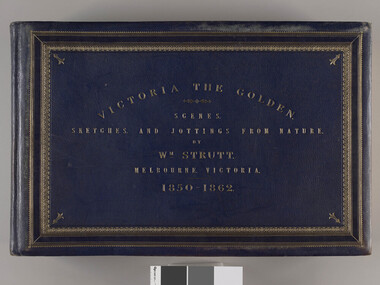
Victoria the Golden, Strutt, William 1825-1915, Victoria the golden : scenes, sketches, and jottings from nature, 1850-1862, 1850-1862, c.1895
"Victoria the Golden" documents life in Victoria between 1850 and 1862 as viewed by artist William Strutt. Momentous events in the Colony’s history such as Separation Day (1 July 1851), the sitting of the first Legislative Council (13 November 1851), the death of Burke (June 1861) and the Black Thursday bushfires (6 February 1851) are depicted. In 1907 the Premier of Victoria Thomas Bent purchased "Victoria the Golden" from Strutt for £120 and presented it to the Library. The album depicts events in chronological order with what Strutt considered “fidelity to nature and accuracy”, so that present day Victorians may view the sketches “as records of what we may now look upon as the dim past in the rapidly progressive history of Victoria”. Victoria the Golden is celebrated as one of the Parliament’s great treasures. It is a testament to William Strutt’s skill as a draughtsman and contains over 100 assorted images which were executed between the years of 1850-1862. Strutt’s particular talent was to be able to step back and record each event with particular care to detail. Many of the pieces contained within this album are littered with notes, such as the correct resting position of a corporal’s sword or details about the cloth and cut of a subject’s jacket. Strutt also notes in one of his many sketches of the new Legislative Council chamber at Spring Street that the President, Sir James Palmer, is seated ‘a little too high’ (page 30). Throughout the album, Strutt’s illustrations bring to life the diverse nature and peoples of the new colony. His range of subjects is comprehensive and includes parliamentarians, lawyers, wives and daughters, merchants, labourers, police and military officers, indigenous communities, farmers, miners, prisoners and explorers. The everyday and the extraordinary are depicted with each turn of the page. 44 leaves heavy card, approximately 1mm thick. Sketches, watercolours and prints of varying sizes and papers are glued onto the pages. Full leather binding in blue leather with title and decorative border in gold. There are four raised bands on the spine, with gold decoration on the bands and at the head and tail of the spine. Marbled end papers and flyleaves. Gold on the edges of the book block. Card pages have a sheet of mottled blue paper on recto. Album leaf connection is a guarded system with stiff stubs and cloth hinges. Each page has a sheet of glassine paper attached at the binding edge to protect the images. Many pages stamped with "Parliament of Victoria" verso. Printed in gold, recto: "VICTORIA THE GOLDEN/ SCENES,/ SKETCHES,/ AND JOTTINGS FROM NATURE./ BY/ Wm. STRUTT/ MELBOURNE, VICTORIA./ 1850-1862" First pages include handwritten 'introductory remarks' and index of plates.parliament of victoria, colony of victoria, separation day, victorian legislative council, burke and wills expedition, wills, william john, 1834-1861, burke, robert o'hara, 1821-1861, strutt, william, 1825-1915, bent, thomas sir, 1838-1909, native police corps, fawkner, john pascoe, 1792-1869, black thursday bushfires, gold rush, princes bridge, melbourne -
 Vision Australia
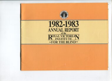
Administrative record - Text, Royal Victorian Institute for the Blind annual report 1982-1983, 1982-1983
Activities in annual report include: retirement of Ralph Lightfoot, appointment of Frances Warren, opening of Wangaratta regional office, family group home in second year providing home environment for three children, establishment of self contained flat within residential services at Burwood, bushfires threatened but did not destroy Wahpeton at Romsey and ski lodge at Mt Baw Baw, and support from hotels through 80 Lucky Envelope machines.1 volume of printed material with imagesannual report, royal victorian institute for the blind -
 Falls Creek Historical Society
Photograph - Ray Meyer at Roper's Hut
MEYER COLLECTION - FALLS CREEK PHOTOS In 1947 a determined group of like-minded State Electricity Commission (SEC) staff including Ray Meyer, the chief surveyor of the Kiewa Hydro-Electric Scheme, had a common interest that revolved around the skiing potential of the snow-covered high plains which included what is now the resort of Falls Creek. The six SEC employees, Toni St Elmo, Ray Meyer, Jack Minogue, Lloyd Dunn, Adrian Ruffenacht and Dave Gibson (together with their families) banded together to secretly build a 'hut' that was the first ski lodge at Falls Creek. Using a road built in 1930s to gain access to Falls Creek, their hut project was carried out in secret as efforts by other skiers were blocked by H.H.C. Williams – the engineer in charge of the Hydro Scheme. In 1946 Ray Meyer made a trip to the Lands Office in Melbourne. He came away with a 99-year lease on three acres that was ideally suited for a hut designed by Lloyd Dunn. Adrian Ruffenacht (Design Engineer for the KHS) had suggested where the group should build because of easy access to a spring for water. Much of the building material required was scavenged from derelict huts on the high plains. Due to the need for secrecy, the determined group worked on the hut in the evenings and weekends to avoid detection. During the building period the group had met at Echidna Rock (now known as Eagle Rock) where Skippy St Elmo announced, "This is my favourite ‘Skyline’.” And so the first lodge in the area at Falls Creek Ski Resort came into existence. With the development of the International Poma in the 1970s, the Skyline Lodge, which was sited between the ski-lift’s pole one and pole two, was demolished. However, the legacy of Ray Meyer, Toni St Elmo, Jack Minogue, Lloyd Dunn, Adrian Ruffenacht and Dave Gibson and Skyline lives on in the vibrant atmosphere of Falls Creek Resort. The MEYER COLLECTION documents developments on the Kiewa Hydro Scheme and their life at Falls Creek from the mid 1930s to 1960s.These images are significant because they depict aspects of the life of a pioneering family of Falls Creek and the founders of "Skyline", the first lodge at Falls Creek.Two black and white images of Ray Meyer outside Roper's Hut. Frederick Roper and his family grazed the Bogong High Plains from the 1890s until 1908. Frederick "Jack" built three huts. The hut known as Roper’s Hut was built on Jack's new grazing lease after his former run had been acquired by the SEC in the late 1930s. It had become a well-used refuge hut prior to its destruction in the 2003 bushfires. It was rebuilt by Victorian High Country Huts Association in 2008.falls creek, building skyline, skyline founders, toni st elmo, adrian ruffenacht, jack minogue, ray meyer, lloyd dunn, david gibson -
 Falls Creek Historical Society
Photograph - John Meyer near Wilkie and Basalt Hill
MEYER COLLECTION - FALLS CREEK PHOTOS In 1947 a determined group of like-minded State Electricity Commission (SEC) staff including Ray Meyer, the chief surveyor of the Kiewa Hydro-Electric Scheme, had a common interest that revolved around the skiing potential of the snow-covered high plains which included what is now the resort of Falls Creek. The six SEC employees, Toni St Elmo, Ray Meyer, Jack Minogue, Lloyd Dunn, Adrian Ruffenacht and Dave Gibson (together with their families) banded together to secretly build a 'hut' that was the first ski lodge at Falls Creek. Using a road built in 1930s to gain access to Falls Creek, their hut project was carried out in secret as efforts by other skiers were blocked by H.H.C. Williams – the engineer in charge of the Hydro Scheme. In 1946 Ray Meyer made a trip to the Lands Office in Melbourne. He came away with a 99-year lease on three acres that was ideally suited for a hut designed by Lloyd Dunn. Adrian Ruffenacht (Design Engineer for the KHS) had suggested where the group should build because of easy access to a spring for water. Much of the building material required was scavenged from derelict huts on the high plains. Due to the need for secrecy, the determined group worked on the hut in the evenings and weekends to avoid detection. During the building period the group had met at Echidna Rock (now known as Eagle Rock) where Skippy St Elmo announced, "This is my favourite ‘Skyline’.” And so the first lodge in the area at Falls Creek Ski Resort came into existence. With the development of the International Poma in the 1970s, the Skyline Lodge, which was sited between the ski-lift’s pole one and pole two, was demolished. However, the legacy of Ray Meyer, Toni St Elmo, Jack Minogue, Lloyd Dunn, Adrian Ruffenacht and Dave Gibson and Skyline lives on in the vibrant atmosphere of Falls Creek Resort. The MEYER COLLECTION documents developments on the Kiewa Hydro Scheme and their life at Falls Creek from the mid 1930s to 1960s.These images are significant because they depict aspects of the life of a pioneering family of Falls Creek and the founders of "Skyline", the first lodge at Falls Creek.Two black and white images of John Meyer skiing near Wilkie and Basalt Hill, Bogong High Plains. Wilkinson’s Hut (Wilkie) was built for the SEC in the summer of 1932-3 to accommodate the snow research program manager. The cottage was sited next to a hydro-meteorological station, set on stilts above the snow. It was not a refuge hut but a permanent residence for all of the year. The work carried out there included operation of a meteorological station at the cottage, measuring the snow depth and density along two pole lines, and operating stream gauging stations in the area. The engineers stationed there included Adrian Rufenacht (1934-6), and Norwegian Martin Romuld (1936-42) Romuld was a champion skier, constructing a ski-jump and a grass tennis court near the hut during his residency. Adrian was one of the founders of 'Skyline". The hut was sold in 1948 to the Victorian Ski Club and renamed Wilkinson Lodge. Robert Wood Wilkinson, best known as 'Wilkie, was the 'Father figure' of Victorian skiing. Robert Wood Wilkinson died on May 22, 1939. The hut was resold some 12 years later to the Melbourne Bushwalkers club. In 1983, the National Parks Service described the building as an old SEC hut which had been purchased and, afterwards, maintained and occupied solely by the Melbourne Bushwalking Club. Wilkie Hut survived the 2003 bushfires but burnt down one year later (January 2004) in a cooking accident.falls creek, ray meyer, skyline -
 Falls Creek Historical Society
Photograph - Joan Meyer at Bogong High Plains
MEYER COLLECTION - FALLS CREEK PHOTOS In 1947 a determined group of like-minded State Electricity Commission (SEC) staff including Ray Meyer, the chief surveyor of the Kiewa Hydro-Electric Scheme, had a common interest that revolved around the skiing potential of the snow-covered high plains which included what is now the resort of Falls Creek. The six SEC employees, Toni St Elmo, Ray Meyer, Jack Minogue, Lloyd Dunn, Adrian Ruffenacht and Dave Gibson (together with their families) banded together to secretly build a 'hut' that was the first ski lodge at Falls Creek. Using a road built in 1930s to gain access to Falls Creek, their hut project was carried out in secret as efforts by other skiers were blocked by H.H.C. Williams – the engineer in charge of the Hydro Scheme. In 1946 Ray Meyer made a trip to the Lands Office in Melbourne. He came away with a 99-year lease on three acres that was ideally suited for a hut designed by Lloyd Dunn. Adrian Ruffenacht (Design Engineer for the KHS) had suggested where the group should build because of easy access to a spring for water. Much of the building material required was scavenged from derelict huts on the high plains. Due to the need for secrecy, the determined group worked on the hut in the evenings and weekends to avoid detection. During the building period the group had met at Echidna Rock (now known as Eagle Rock) where Skippy St Elmo announced, "This is my favourite ‘Skyline’.” And so the first lodge in the area at Falls Creek Ski Resort came into existence. With the development of the International Poma in the 1970s, the Skyline Lodge, which was sited between the ski-lift’s pole one and pole two, was demolished. However, the legacy of Ray Meyer, Toni St Elmo, Jack Minogue, Lloyd Dunn, Adrian Ruffenacht and Dave Gibson and Skyline lives on in the vibrant atmosphere of Falls Creek Resort. The MEYER COLLECTION documents developments on the Kiewa Hydro Scheme and their life at Falls Creek from the mid 1930s to 1960s.These images are significant because they depict aspects of the life of a pioneering family of Falls Creek and the founders of "Skyline", the first lodge at Falls Creek.Two black and white images of John Meyer skiing near Wilkie and Basalt Hill, Bogong High Plains. Wilkinson’s Hut (Wilkie) was built for the SEC in the summer of 1932-3 to accommodate the snow research program manager. The cottage was sited next to a hydro-meteorological station, set on stilts above the snow. It was not a refuge hut but a permanent residence for all of the year. The work carried out there included operation of a meteorological station at the cottage, measuring the snow depth and density along two pole lines, and operating stream gauging stations in the area. The engineers stationed there included Adrian Rufenacht (1934-6), and Norwegian Martin Romuld (1936-42) Romuld was a champion skier, constructing a ski-jump and a grass tennis court near the hut during his residency. Adrian was one of the founders of 'Skyline". The hut was sold in 1948 to the Victorian Ski Club and renamed Wilkinson Lodge. Robert Wood Wilkinson, best known as 'Wilkie, was the 'Father figure' of Victorian skiing. Robert Wood Wilkinson died on May 22, 1939. The hut was resold some 12 years later to the Melbourne Bushwalkers club. In 1983, the National Parks Service described the building as an old SEC hut which had been purchased and, afterwards, maintained and occupied solely by the Melbourne Bushwalking Club. Wilkie Hut survived the 2003 bushfires but burnt down one year later (January 2004) in a cooking accident.falls creek, joan meyer, bogong high plains -
 Falls Creek Historical Society
Photograph - Bogong Trip 1951- Mt. Bogong from above Roper's Hut
MEYER COLLECTION - FALLS CREEK PHOTOS In 1947 a determined group of like-minded State Electricity Commission (SEC) staff including Ray Meyer, the chief surveyor of the Kiewa Hydro-Electric Scheme, had a common interest that revolved around the skiing potential of the snow-covered high plains which included what is now the resort of Falls Creek. The six SEC employees, Toni St Elmo, Ray Meyer, Jack Minogue, Lloyd Dunn, Adrian Ruffenacht and Dave Gibson (together with their families) banded together to secretly build a 'hut' that was the first ski lodge at Falls Creek. Using a road built in 1930s to gain access to Falls Creek, their hut project was carried out in secret as efforts by other skiers were blocked by H.H.C. Williams – the engineer in charge of the Hydro Scheme. In 1946 Ray Meyer made a trip to the Lands Office in Melbourne. He came away with a 99-year lease on three acres that was ideally suited for a hut designed by Lloyd Dunn. Adrian Ruffenacht (Design Engineer for the KHS) had suggested where the group should build because of easy access to a spring for water. Much of the building material required was scavenged from derelict huts on the high plains. Due to the need for secrecy, the determined group worked on the hut in the evenings and weekends to avoid detection. During the building period the group had met at Echidna Rock (now known as Eagle Rock) where Skippy St Elmo announced, "This is my favourite ‘Skyline’.” And so the first lodge in the area at Falls Creek Ski Resort came into existence. With the development of the International Poma in the 1970s, the Skyline Lodge, which was sited between the ski-lift’s pole one and pole two, was demolished. However, the legacy of Ray Meyer, Toni St Elmo, Jack Minogue, Lloyd Dunn, Adrian Ruffenacht and Dave Gibson and Skyline lives on in the vibrant atmosphere of Falls Creek Resort. The MEYER COLLECTION documents developments on the Kiewa Hydro Scheme and their life at Falls Creek from the mid 1930s to 1960s.This image is significant because it depicts aspects of the life of a pioneering family of Falls Creek and the founders of "Skyline", the first lodge at Falls Creek.Black and White Image of Mt. Bogong from above Roper's Hut with Wal Johnson and Ray Meyer seated on the ground. ROPER'S HUT Frederick Roper and his family grazed the Bogong High Plains from the 1890s until 1908. Frederick "Jack" built three huts. The hut known as Roper’s Hut was built on Jack's new grazing lease after his former run had been acquired by the SEC in the late 1930s. It had become a well-used refuge hut prior to its destruction in the 2003 bushfires. It was rebuilt by Victorian High Country Huts Association in 2008.falls creek, bogong high plains, wal johnson, ray meyer, ropers hut -
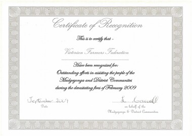 Victorian Farmers Federation
Work on paper - Certificate of recognition, Outstanding efforts in assisting the people of Mudgegonga and District Communities during devastating fires of February 2009
Relates to the Black Saturday bushfires in Victoria in February 2009A4 certifcate on paperbushfire, recovery, agriculture, farming, rural community -
 Forests Commission Retired Personnel Association (FCRPA)
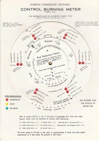
FCV Control burning meter, 1970
The Forest Fire Danger Index (FFDI) was originally invented by the grandfather of Australian bushfire science, Alan Grant McArthur, during the 1950s and ‘60s. Alan published his landmark paper, “Controlled burning in eucalypt forests” in 1962. Leaflet No. 80, as it was known, proved a turning point for forest and fire managers across Australia. More importantly, Alan was very practical forester and wanted his work to be useful to people in the field, so after several iterations he came up with the now familiar circular slide rule called the Forest Fire Danger Meter (FFDM). The Mk 4 version first appeared in operational use in 1967. Two Forests Commission staff, Athol Hodgson and Rus Ritchie, built on McArthur’s pioneering work and by applying their own practical experience, developed a modified version in the late 1960s called the Control Burning Meter which was better suited to Victorian forest conditions.Introduced to the FCV in 1970Control burning meterbushfire, forests commission victoria (fcv) -
 Forests Commission Retired Personnel Association (FCRPA)
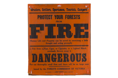
Bushfire awareness sign, Protect your forests from fire, 1953
Bushfire Prevention Week was initiated by the Forests Commission in 1930. Victoria’s State Governor, Lord Somers, the Lord Mayor of Melbourne, Sir Harold Luxton and the newly appointed Minister for Forests, William Beckett launched the innovative campaign with great flourish to 250 invited guests at Melbourne’s opulent Town Hall on Monday 13 January 1930. Special church sermons had been held previously on Sunday. The packed program of gala events included lavish luncheon talks at city clubs, scholarly lectures broadcast on the wireless, together with daily articles in the Melbourne and country press about the pressing need for fire prevention. The slogan for the ground-breaking campaign was… Prevent Bush Fires – It Pays… The Shell Petrol Company of Australia supplied 15000 windshield stickers, the British Australasian Tobacco Company donated a large supply of stamp stickers, while many other companies drew attention to the campaign in their newspaper advertisements. The Victorian Railways and many city firms displayed special fire posters, while Bryant and May posted messages on their limited-edition matchbox covers which are now highly prized by phillumenists (i.e. matchbox collectors). The Postmaster General's Department franked postage stamps and letters with special bushfire slogans. While plainclothes police were secretly deployed to the bush to arrest potential arsonists. Canvas and enamel fire prevention signs were erected on most roads leading to forest areas. Letters to the Editor later appeared in many city and country newspapers extolling the virtues of Bushfire Prevention Week and urging for its continuation as an annual event. Although a new idea for Australia, the Canadian Forest Service had been running a similar program for a few years. The Forests Commission in its 1929-30 Annual Report, under the title of "Propaganda", noted with some glee… "One of the most gratifying features of the ''Week" was its low cost to the Government, the major part of the publicity material being donated by private firms." And so for the next 50 years until the 1980s, Bushfire Prevention Week continued unabated with the Forests Commission producing a series of coloured “Magic Lantern” slides which were manufactured by Alex Gunn and Sons in Collins Street Melbourne for screening at Val Morgan cinemas. The slides famously introduced the menacing character, Willy Wildfire, warning motorists to be careful with matches. Now known as Fire Action Week, it remains a key event in the annual calendar for both DEECA and the CFA and is still going strong... These canvas fire awareness signs were used right throughout the period of the Forests Commission until the mid 1980sBushfire awareness signProtect your forests from firebushfire, forests commission victoria (fcv), forest signs -
 Forests Commission Retired Personnel Association (FCRPA)
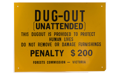
Dugout sign, Post 1966
Considered in terms of both loss of property and loss of life, the Black Friday bushfires on 13 January 1939 were one of the worst disasters to have occurred in Australia and certainly the worst bushfire up to that time. The fires burnt 2 million hectares, 69 sawmills were destroyed, 71 people died, and several towns and sawmills were entirely obliterated. Among those killed were four men from the Commission The subsequent Royal Commission conducted by Judge Leonard Stretton has been described as one of the most significant inquiries in the history of Victorian public administration. Its recommendations led to sweeping changes. In addition to building dams and water points, the Stretton Royal Commission recommended expanding and controlling the use of bushfire dugouts at forest sawmills. Well-constructed dugouts had saved the lives of many sawmill workers and their families during the 1939 bushfires. But in some locations, they had proved fatal. Dugouts became mandatory for those few sawmills that remained in the forest after the 1939 fires. Many remote logging coupes and FCV roading camps also had dugouts. The local District Forester was required to make annual pre-season inspections of all dugouts on State forests and those within the Fire Protected Area (FPA). Some were built privately on private land. Most were primitive construction with a log or corrugated iron roof covered with earth. A hessian bag often hung at the entrance to keep the heat and smoke out. But they were dark and damp with snakes and other creepy crawlies often lurking inside. By 1940-41 there were 19 new dugouts constructed by the Commission and a further 128 by forest licensees. Ten years later there were 8 new Commission dugouts and 21 new ones built by other interests. By 1960-61 the rate of new builds was declining but the Commission still managed 103 dugouts while 127 were looked after by others. However, as the forest road network improved and gave all-weather access to modern two-wheel-drive vehicles the reliance on dugouts receded.Large metal sign that was positioned near forest dugoutsbushfire, forest signs, forests commission victoria (fcv) -
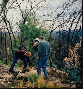 Wooragee Landcare Group
Photograph, 12th September 2004 or 15rh September 2004
This photograph was taken at Wooragee Landcare workshop (Quoll), field day in Mt Pilot park on Bush Recovery: After the Fires. This is part of the Biodiversity Month on September 2004. The Bush Recovery workshop was held on Sunday 12th September 2-4pm with Christine Watson, Sue Berwick and Natasha Schedvin, and another workshop on Wednesday, 15th September, 9am to 12 noon with local biologist Glen Johnson and botanists Gill Earl and Christine Watson. The topics involved in the training involved what species have returned, what species haven't, what recovery studies are being carried out, how are the barking owls and phascogales faring, and why is Mt Pilot important. The photograph shows L-R: Colin Payne; Jerry Alexander; Geoff Galbraith. Bush fires are common in Australia due to several reasons. One is due to the geographic spread of fire's seasons, secondly, the absence of El Nino conditions are also linked to fires. Climate change also affected Australia's hot and dry seasons. Australia's climate began warming since the 1970s. Human-induced fires also contributed to this increase in temperatures across the nation. Bush fires happened in Mt Pilot in 2003 but it has recovered well since. This makes Mt Pilot an important site to understand bushfire recovery. This photograph contributes to the scientific and historical records on bushfire recovery in Victoria. It creates a picture of Victorian community activities and efforts on biodiversity, climate change, and environmental care.Landscape coloured photograph printed on gloss paperReverse: WAN NA 0A2A0N0 NN2 0 163 / (No. 2)wooragee, wooragee landcare group, wooragee landcare, bush fires, bush recover, mt pilot, biodiversity month, botany, botanists, bush recovery, quoll, foxy, fox, forest, environment, climate change, bushfire recovery, bushfires, 2004 bushfire, field work, after the fires, fire, biodiversity -
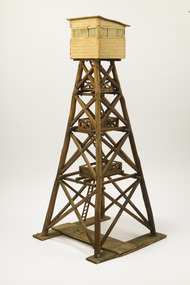 Forests Commission Retired Personnel Association (FCRPA)
Wooden Model Fire Tower, Tom Coish, Model of Reef Hills fire tower, (5 km south of Benalla), 1957
Victoria once had well over one hundred fire lookouts and firetowers. Fire lookouts, or observation posts, were often just a clearing on a hill or a vantage point, whereas firetowers were definite structures. There are at least three categories of firetowers… (1) tree perches, (2) four-legged towers made of either wood or steel, as well as (3) hilltop cabins and observatories. Many were established by the Forests Commission Victoria (FCV) in the 1920s, but the network was expanded rapidly in response to recommendations of the Stretton Royal Commission after the 1939 Black Friday bushfires. The wooden towers were often built by bush craftsmen like legendary FCV overseer Clem Heather from Orbost. But advances in aerial reconnaissance and radio technology led to the gradual reduction in the number of fixed towers. FFMV now operates 72 firetowers. The CFA, Melbourne Water, Hancock Victorian Plantations (HVP) also operate some, the Army has one at Puckapunyal overlooking the live-firing range. Only two remaining fire towers of this design remain in Victoria (Mt Little Dick and Big Tower in the Mullungdung State Forest). Mt Nowa Nowa and Stringers Knob burnt down in the 2019/20 bushfiresLarge model of an Reef Hills fire tower. Presumably used for instructional purposes. Traditional FCV four legged design with three landings and closed cabin.bushfire, forests commission victoria (fcv) -
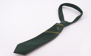 Forests Commission Retired Personnel Association (FCRPA)
Uniform - Forests Commission Victoria (FCV) tie and epaulets (to be worn on polyester shirt) as dress uniform, pre 1984
Polyester shirts plus a green tie and epaulets were the only form of dress unform issued to FCV staff. In later years a brown tie was available. Blue work overalls and safety boots were issued for bushfire work. These were replaced with the now familiar bright green overalls in about 1984. There were no dress pants, jumpers, jackets or shoes issued. This led to a long running dispute between the staff association and the Commission over departmental uniform policy at the time. David Parnaby was a District Forester and accomplished cartoonist who provided insightful and humorous commentary on uniforms through the Victorian State Forester’s Association Newsletter.Example of early staff uniform.Green polyester tie with yellow stripe and round FCV logo. Green FCV epaulet to be worn on polyester shirt as dress uniform. uniforms, forests commission victoria (fcv) -
 Eltham District Historical Society Inc
Photograph - Digital Photograph, Alan King, Eltham Railway Trestle Bridge, 28 December 2007
Covered under National Trust of Australia (Victoria) State Significance and Heritage Overlay, Nillumbik Planning Scheme. Published: Nillumbik Now and Then / Marguerite Marshall 2008; photographs Alan King with Marguerite Marshall.; p103 The Eltham railway trestle bridge is the only one of its kind still regularly used in Melbourne’s metropolitan railway network. Opened in 1902, it is also one of Victoria’s very few timber rail bridges that still carries trains.1 The bridge is part of the railway line extension from Heidelberg - extended to Hurstbridge in 1912. This extension resulted in one of the greatest social changes experienced in Eltham Shire, as it considerably lessened its isolation attracting tourists, artists and suburban commuters particularly after World War Two.2 The bridge has been classified by the National Trust as historically, scientifically, aesthetically and socially significant at state level. But this has not always been recognised, and in 1977, locals fought to save it from destruction. The Victorian Railways proposed to replace the bridge with an earth embankment and large culverts to avoid maintenance problems and fire. This was rejected by the Eltham Council who protested that the bridge helped maintain the area’s rural character, historic link and beauty, as well as avoiding possible serious flooding on the flood plain if a culvert was blocked. The bridge stands as part of a National Trust classified landscape which includes the Alistair Knox Park, named after the local conservationist and architect who helped to make Eltham famous for its mud-brick houses. The landscape includes tall and spreading manna gums and candlebarks, and the historic Shillinglaw Cottage. Artist Walter Withers, one of the Heidelberg School of painters, painted the bridge early in the 20th century. The 38 span single-track railway bridge over creek and road has 34 timber-beam spans and four steel-joist spans, supported by four-pile timber piers and timber abutments. It has almost 200m of timber deck. All of the timbers have been replaced over the years, but the only change to the bridge’s character was the addition of pylons and wiring for electric trains in 1923. A petition for a railway to the shire was first made in 1883. A large deputation of local citizens to the Commissioner of Railways proposed a route passing through Alphington to midway between Greensborough and Eltham up the Diamond Creek valley towards Queenstown and Kinglake. As a result the Princes Bridge-Heidelberg Railway was opened in 1888. From 1888 locals demanded a railway extension. Kangaroo Ground farmers in particular, led by Shire Councillor and Member for Evelyn, Ewen Cameron, said it would assist local farmers and orchardists send their produce to the Melbourne market. In 1890, before the severe economic Depression, an extension of the line to Hurst’s Bridge (now Hurstbridge) was included in a new Railways Bill. The parliamentary delegations were regaled with a banquet at Hurst’s barn and entertained by the Diamond Creek Brass Band, but the extension was abandoned when the Depression struck in 1892-1893. The extension of the railway to Eltham, completed in 1902, was one of the few built in those hard times. That is why the Eltham timber-trestle railway bridge is a rare example of a broad-gauge rail bridge constructed between 1893 and 1910. At the opening, despite persistent drizzle, 300 children waving flags and banners were among the large crowd welcoming the first train, carrying official dignitaries, to Eltham. It had taken 24 years to bring the railway to Eltham. From then Eltham became a popular destination for outings. Mr Orford of Eltham recalled that after the railway came to Eltham ‘the craze for picnics on weekends and holidays began…. During the wattle season, wattle trains came to Eltham frequently. The visitors roamed the creek pulling great armfuls of wattle blossom to take back with them to Melbourne’.3 In 1926 the railway line was electrified as part of the metropolitan rail network. But the Victorian Railways decided not to complete the formerly planned Diamond Valley Railway to Queenstown (now St Andrews) and Kinglake.This collection of almost 130 photos about places and people within the Shire of Nillumbik, an urban and rural municipality in Melbourne's north, contributes to an understanding of the history of the Shire. Published in 2008 immediately prior to the Black Saturday bushfires of February 7, 2009, it documents sites that were impacted, and in some cases destroyed by the fires. It includes photographs taken especially for the publication, creating a unique time capsule representing the Shire in the early 21st century. It remains the most recent comprehenesive publication devoted to the Shire's history connecting local residents to the past. nillumbik now and then (marshall-king) collection, eltham railway trestle bridge, eltham trestle bridge -
 Eltham District Historical Society Inc
Photograph - Digital Photograph, Marguerite Marshall, Former home of Alistair and Margot Knox, King Street, Eltham, 16 January 2006
Situated in King Street, Eltham, Alistair Knox built his home and office in 1962-1963 with mud-bricks made from the local soil and recycled materials blending the house with bush around it. Knox popularised the Eltham earth building movement, begun by Montsalvat founder, Justus Jorgensen. Alistair Knox (1912-1986) was also an Eltham Shire Councillor 1971-1975 and Shire President in 1975. Knox established the inaugural Eltham Community Festival in 1975. Covered under Heritage Overlay, Nillumbik Planning Scheme. Published: Nillumbik Now and Then / Marguerite Marshall 2008; photographs Alan King with Marguerite Marshall.; p145 Lack of money was a strong incentive for Alistair Knox to do what he did best when he built his house and office at King Street, Eltham in 1962-63. He used mud-bricks from local soil and recycled materials, characteristically blending the house with the bush around it. The result was a work of art. Knox popularised the Eltham earth building movement,1 begun by Montsalvat founder Justus Jörgensen. He was also an Eltham Shire Councillor from 1971 to 1975 and Shire President in 1975. For Knox mud-brick building was not just a building style, but a spiritual experience and a way of relating with nature. At 40 he rediscovered God and his building reflected his theological, political, philosophical and particularly environmental world view, which was far ahead of its time.2 He also contributed to building development in his use of concrete slab foundations when stumps and bearers were the norm. Knox was introduced to mud-brick construction in 1940 by Jörgensen, then shortly after, Knox joined the Navy. In 1946 Knox studied Building Practice and Theory at Melbourne Technical College (now RMIT University). There he befriended fellow student and artist Matcham Skipper who belonged to what was then called the Jörgensen Artists’ Colony. Knox decided to build an earth building in Eltham, partly because the post-war huge building demands resulted in expensive and scarce building materials. He asked artist Sonia Skipper for help who, with Matcham, had constructed mud-brick buildings at the Artists’ Colony. The simple rectangular low-lying house at King Street is framed by native plants and a 3.6 metres wide pergola surrounds the building. Wedded to the landscape, a door in every room at the perimeter, opens outside. The property also includes a forge, a small hut built by son Macgregor at 15, and a mud-brick tower for chickens. Building materials were foraged from a wide variety of sources. Some of the joinery material came from old whisky vats. When the Oregon of the highest quality ‘was put through the wood-working machines, it gave off a deep smell of whisky that made the whole atmosphere exotic and heady’.3 Amateur builders, including schoolboys from Knox’s Presbyterian Church, made some of the mud-bricks. But the building was finished with the professional help of Yorkshire builder, Eric Hirst. Inside, the light is subdued with the mud-brick, beamed timber ceilings and floors of slate, timber or orange-brown tiles. Skylights, with rich blue and red leadlighting, illuminate one entrance area and this feature is repeated as edging on the door. The centre of the house is like a covered courtyard, with rooms built around it. The central room, 11 metres x 7 metres, was built in the same proportions as Knox’s mud-bricks. Clerestory windows on four sides infuse the room with a soft light. A huge brick fireplace extends beyond one corner and opposite is a small one where timber can only be placed vertically. The slate for the floor was discarded from the Malthouse Brewery now used as a theatre in Southbank. In the middle is a large refectory table and benches that seat 18. Like much of the house, it is rugged, yet beautiful. Made of Western Australian Jarrah by Macgregor with a chain saw and an adze, it retains knot and nail holes. Each wall has an opening, 2.4 metres at the ends and 3.6 metres at the sides. Only one has doors and these concertina doors are made of the backs of old church pews. The main bedroom has an ensuite with a marble hand basin discarded from the Victorian Parliament building; and a dressing room, where two wardrobes of polished timber recovered from a tip are attached to the walls. Separate from the house is the strikingly original circular-shaped office made of bluestone sourced from the original Army campsite at Broadmeadows.This collection of almost 130 photos about places and people within the Shire of Nillumbik, an urban and rural municipality in Melbourne's north, contributes to an understanding of the history of the Shire. Published in 2008 immediately prior to the Black Saturday bushfires of February 7, 2009, it documents sites that were impacted, and in some cases destroyed by the fires. It includes photographs taken especially for the publication, creating a unique time capsule representing the Shire in the early 21st century. It remains the most recent comprehenesive publication devoted to the Shire's history connecting local residents to the past. nillumbik now and then (marshall-king) collection, alistair and margot knox house, alistair knox design, mudbrick construction, eltham, king street -
 Eltham District Historical Society Inc
Photograph - Digital Photograph, Marguerite Marshall, 'Worlingworth', 10-26 Banoon Road, Eltham, 30 January 2006
'Worlingworth', Eltham, home of noted anthropologist the late Professor Donald Thomson and his wife Dorita Thomson. Covered under Heritage Overlay, Nillumbik Planning Scheme. Published: Nillumbik Now and Then / Marguerite Marshall 2008; photographs Alan King with Marguerite Marshall.; p127 Dubbed as ‘Australia’s Lawrence of Arabia’ anthropologist Donald Thomson lived much of his life in Eltham, at Banoon Road. On his retirement as Professor of Anthropology in 1968, The University of Melbourne professorial board compared Thomson to Lawrence of Arabia because of his work for Aborigines and his controversial personality. Although Thomson is now recognised for his huge contribution, during his lifetime he suffered opposition and his life has been described as ‘tragic’.1 Thomson failed to gain the recognition as a scientist that he felt he deserved and he failed to alter government policy towards Aboriginal people. But towards the end of his life in 1970, anthropologists were moving towards the type of research he had done and the movement to grant land rights to Aborigines was strengthening. Thomson is best known for his anthropological fieldwork in Cape York, Arnhem Land and Central Australia, but he is also known for his scholarly contributions to ornithology and ecology. Thomson documented every aspect of the daily and ritual life of the Aboriginal world of Cape York and Arnhem Land in the 1930s and 1940s. The huge collection in Museum Victoria includes 11,000 photographs, 7500 items of material culture, 1000 botanical and zoological specimens and 4500 pages of field-notes.2 The film Ten Canoes used Thomson’s photographs as a source. Thomson bought the Eltham property known as Worlingworth in 1934. The single-storey 60-square house standing by the Yarra River was built in 1922-23. It is one of the last in Eltham to survive with its farm setting intact. It is also one of the few substantial residences built in the Eltham Shire from the late 19th century to the early 20th century, which signalled a major change in the area towards the residential municipality it is today.3 The original section, built in the mid 1860s, of rose pink hand-made bricks and stone quarried on the property, was incorporated in the new red-brick house built in 1922. An immense oak tree by the house grew from an acorn brought by Patrick Armstrong who first bought the land in March 14, 1862. Armstrong named Worlingworth after his forbears’ village in Suffolk, England. Worlingworth saw grand days when Commander Alan A Barlee (R.N.) bought it in 1922 after winning the Calcutta Sweep. The property then included a nine-hole golf course, a tennis court, a bowling green, a boathouse and a boat-ramp.4 For most of his career Thomson, who was born in 1901, was attached to The University of Melbourne. In 1935 he represented the Commonwealth Government at Caledon Bay in east Arnhem Land to investigate and mediate for four Aborigines accused of killing five Japanese and three Europeans. In 1938 Thomson was awarded a PhD in Anthropology at Cambridge University, and during his career, he received several medals from British Societies, who perhaps appreciated his work better than their Australian counterparts. From World War Two, Thomson suffered a string of hardships, beginning with severe wounding in Dutch New Guinea (for his military service in New Guinea he was awarded an OBE) and he was invalided from service in 1944. That year he was diagnosed with diabetes. A fire in 1946 destroyed what Thomson regarded as perhaps the best record he had made of Aboriginal life – the 20,000 feet, (6096m) of film he had shot in Arnhem Land. In 1954 he and wife, Gladys, divorced. The next year he married his technical assistant, Dorita McColl. Several times during his career Thomson had major disagreements. For instance Professor P Elkin constantly opposed his work. He also opposed Thomson when he campaigned vigorously in 1947 against the establishment of a rocket range at Woomera, South Australia, because of the threat it posed Aborigines. Thomson resigned in frustration from the Victorian Aborigines Welfare Board in 1967, after serving for ten years, because he found that his advice was disregarded. His ashes were scattered over Caledon Bay from the air.This collection of almost 130 photos about places and people within the Shire of Nillumbik, an urban and rural municipality in Melbourne's north, contributes to an understanding of the history of the Shire. Published in 2008 immediately prior to the Black Saturday bushfires of February 7, 2009, it documents sites that were impacted, and in some cases destroyed by the fires. It includes photographs taken especially for the publication, creating a unique time capsule representing the Shire in the early 21st century. It remains the most recent comprehenesive publication devoted to the Shire's history connecting local residents to the past. nillumbik now and then (marshall-king) collection, banoon road, donald thomson, dorita thomson, eltham, worlingworth -
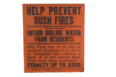 Forests Commission Retired Personnel Association (FCRPA)
Bushfire awareness sign, Help Prevent Bushfires, Pre 1966
Bushfire Prevention Week was initiated by the Forests Commission in 1930. Victoria’s State Governor, Lord Somers, the Lord Mayor of Melbourne, Sir Harold Luxton and the newly appointed Minister for Forests, William Beckett launched the innovative campaign with great flourish to 250 invited guests at Melbourne’s opulent Town Hall on Monday 13 January 1930. Special church sermons had been held previously on Sunday. The packed program of gala events included lavish luncheon talks at city clubs, scholarly lectures broadcast on the wireless, together with daily articles in the Melbourne and country press about the pressing need for fire prevention. The slogan for the ground-breaking campaign was… Prevent Bush Fires – It Pays… The Shell Petrol Company of Australia supplied 15000 windshield stickers, the British Australasian Tobacco Company donated a large supply of stamp stickers, while many other companies drew attention to the campaign in their newspaper advertisements. The Victorian Railways and many city firms displayed special fire posters, while Bryant and May posted messages on their limited-edition matchbox covers which are now highly prized by phillumenists (i.e. matchbox collectors). The Postmaster General's Department franked postage stamps and letters with special bushfire slogans. While plainclothes police were secretly deployed to the bush to arrest potential arsonists. Canvas and enamel fire prevention signs were erected on most roads leading to forest areas. Letters to the Editor later appeared in many city and country newspapers extolling the virtues of Bushfire Prevention Week and urging for its continuation as an annual event. Although a new idea for Australia, the Canadian Forest Service had been running a similar program for a few years. The Forests Commission in its 1929-30 Annual Report, under the title of "Propaganda", noted with some glee… "One of the most gratifying features of the ''Week" was its low cost to the Government, the major part of the publicity material being donated by private firms." And so for the next 50 years until the 1980s, Bushfire Prevention Week continued unabated with the Forests Commission producing a series of coloured “Magic Lantern” slides which were manufactured by Alex Gunn and Sons in Collins Street Melbourne for screening at Val Morgan cinemas. The slides famously introduced the menacing character, Willy Wildfire, warning motorists to be careful with matches. Now known as Fire Action Week, it remains a key event in the annual calendar for both DEECA and the CFA and is still going strong... These canvas fire awareness signs were used right throughout the period of the Forests Commission until the mid 1980sBushfire awareness signHelp Prevent Bushfiresbushfire, forest signs, forests commission victoria (fcv) -
 Forests Commission Retired Personnel Association (FCRPA)
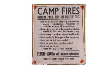
Bushfire awareness sign, Camp Fires, 1962
Bushfire Prevention Week was initiated by the Forests Commission in 1930. Victoria’s State Governor, Lord Somers, the Lord Mayor of Melbourne, Sir Harold Luxton and the newly appointed Minister for Forests, William Beckett launched the innovative campaign with great flourish to 250 invited guests at Melbourne’s opulent Town Hall on Monday 13 January 1930. Special church sermons had been held previously on Sunday. The packed program of gala events included lavish luncheon talks at city clubs, scholarly lectures broadcast on the wireless, together with daily articles in the Melbourne and country press about the pressing need for fire prevention. The slogan for the ground-breaking campaign was… Prevent Bush Fires – It Pays… The Shell Petrol Company of Australia supplied 15000 windshield stickers, the British Australasian Tobacco Company donated a large supply of stamp stickers, while many other companies drew attention to the campaign in their newspaper advertisements. The Victorian Railways and many city firms displayed special fire posters, while Bryant and May posted messages on their limited-edition matchbox covers which are now highly prized by phillumenists (i.e. matchbox collectors). The Postmaster General's Department franked postage stamps and letters with special bushfire slogans. While plainclothes police were secretly deployed to the bush to arrest potential arsonists. Canvas and enamel fire prevention signs were erected on most roads leading to forest areas. Letters to the Editor later appeared in many city and country newspapers extolling the virtues of Bushfire Prevention Week and urging for its continuation as an annual event. Although a new idea for Australia, the Canadian Forest Service had been running a similar program for a few years. The Forests Commission in its 1929-30 Annual Report, under the title of "Propaganda", noted with some glee… "One of the most gratifying features of the ''Week" was its low cost to the Government, the major part of the publicity material being donated by private firms." And so for the next 50 years until the 1980s, Bushfire Prevention Week continued unabated with the Forests Commission producing a series of coloured “Magic Lantern” slides which were manufactured by Alex Gunn and Sons in Collins Street Melbourne for screening at Val Morgan cinemas. The slides famously introduced the menacing character, Willy Wildfire, warning motorists to be careful with matches. Now known as Fire Action Week, it remains a key event in the annual calendar for both DEECA and the CFA and is still going strong... These canvas fire awareness signs were used right throughout the period of the Forests Commission until the mid 1980sBushfire awareness signbushfire, forests commission victoria (fcv), forest signs -
 Forests Commission Retired Personnel Association (FCRPA)
Uniform - Safety Boot (Yellow back), Oliver Stevens in Ballarat, circa 1982
These boots were manufactured by Oliver Stevens in Ballarat to the Forests Commission's own specification. Safety boots were a bit "hit and miss" back in 1981. As well as the steel toe caps these boots had a screwed, glued and stitched Sherpa-pattern rubber nitrile sole. The sole was oil resistant and didn't melt on hot coals. The yellow heels signified safety boots. There were two styles with different leather and staff were all personally fitted and given their choice of style. The only thing that has fundamentally changed over 40 years is there is much more choice and comfort in boots today. These boots proved to be the catalyst for boot manufacturers realising there was a market outside of the armed forces not being served. Ankle injuries along with elastic sided boots were virtually eliminated by these boots. The iconic Tasmanian company, Blundstone, had a work boot called "Forester" at the time. It had won an Australian Design Award and had a bonded Sherpa sole. Unfortunately, the soles tended to separate from the boot under field test conditions. Eventually they perfected the process Oliver Stevens' main issue was not being able to recruit enough workers to meet the increased demand. Info: Trevor Brown.First safety boots issued to Victorian forest firefightersYellow Back safety boots with leather laces. FCV marked on the heel fire fighting, bushfire, forests commission victoria (fcv), protective clothing -
 Forests Commission Retired Personnel Association (FCRPA)
Beechworth FCV District office sign
This sign proudly hung outside the Forests Commission Victoria (FCV) Beechworth office which is now site of the Forestry Heritage Museum. The granite building in the Beechworth's historic precinct was once the Gold Warden's Office and is one of the town's original buildings. The FCV was the main government authority responsible for management and protection of State forests in Victoria between 1918 and 1983. The Commission was responsible for ″forest policy, prevention and suppression of bushfires, issuing leases and licences, planting and thinning of forests, the development of plantations, reforestation, nurseries, forestry education, the development of commercial timber harvesting and marketing of produce, building and maintaining forest roads, provision of recreation facilities, protection of water, soils and wildlife, forest research and making recommendations on the acquisition or alienation of land for forest purposes″. The Forests Commission had a long and proud history of innovation and of managing Victoria's State forests but in September 1983 lost its discrete identity when it was merged into the newly formed Victorian Department of Conservation, Forests and Lands (CFL) along with the Crown Lands and Survey Department, National Park Service, Soil Conservation Authority and Fisheries and Wildlife Service. After the amalgamation the management of State forests and the forestry profession continued but the tempo of change accelerated, with many more departmental restructures occurring over the subsequent four decades. Responsibilities are currently split between the Department of Energy, Environment and Climate Action (DEECA), Forests Fire Management Victoria (FFMV), Parks Victoria, Melbourne Water, Alpine Resorts Commission, the State Government-owned commercial entity VicForests and the privately owned Hancock Victorian Plantations (HVP).Large office sign. Hand painted in traditional FCV mission brown and gold colour scheme.forests commission victoria (fcv), forest signs -
 Falls Creek Historical Society
Book - The Campaign Fires - North-East/East Gippsland Fires 2003, Lyndel Hunter
... is significant because it documents the 2003 Victorian Bushfires ...A description of efforts to fight the bushfires in Gippsland in 2003, including maps and illustrations. This volume was published as a tribute to the work of staff and volunteers who put themselves at risk to protect local communities. It shows the impact on those communities in Victoria and the support they gave to those involved in fighting largest bushfires in Victoria for 60 years. The Alpine bushfires started on 8th January 2003, a day of Total Fire Ban. Lightning ignited 87 fires in the North-East and East Gippsland regions. Eight of these fires were unable to be contained; they joined together to form the largest fire in Victoria since the Black Friday fires in 1939. The majority of the area burnt in Victoria was public land, 1.19 million hectares of parks and forests, including 60 per cent of the Alpine National Park and 81 per cent of the Mt Buffalo National Park. Firefighting efforts were made difficult in hard-to-access, remote forest terrain. Approximately 90,000 hectares of private land was burnt.This book is significant because it documents the 2003 Victorian Bushfires and serves as a tribute to the CFA staff and volunteers who fought them.This publication of 119 pages features text, colour images, maps and detailed information related to the 2003 bushfires in Victoria.At bottom of front cover:- CFA Victoria Logo Victorian Government Logovictorian fires 2003, cfa (vic) -
 Falls Creek Historical Society
Magazine - Brigade Magazine Spring 2016
Brigade Magazine is issued to members of the Victorian CFA. The Spring edition of 2016 includes an article to acknowledge 21 years of service by the Falls Creek CFA. The article was written by Joy Nowakowski on behalf of the Falls Creek CFA with information provided by the Falls Creek Historical Society. Falls Creek Fire Brigade protects Falls Creek Village from fires throughout the year and supports other brigades to fight bushfires nearby and further away. In 2016 the brigade had 23 year-round volunteers. At a celebratory function at Falls Creek in June 2016, alpine pumper and brigade snowmobiles were on display. Falls Creek’s alpine pumper was the first of its kind in Australia. It had a pumping capacity of 4,000 litres a minute and its tracks enabled it to access areas of the village and ski fields. Until 2016 Falls Creek Village has been threatened by two major fires, the worst being in 2003 when CFA crews saved the village and the adjoining ski field infrastructure right at the boundaries. Snow making equipment was used to create a water/fog barrier that helped stop the fires from taking the village. The team that saved the village was considered heroic Support for fighting fires at Falls Creek dates back to 1956 but this support came from Mount Beauty, 30 kilometres down the mountain. Falls Creek locals were concerned by this, so used six available hydrants and a canvas hose to fight any fires on the mountain. In 1964 the SECV gave the village a trailer which could be used with both wheels and skis for summer and winter operations. But this trailer only lasted two years. In the early 1970s, the village was given a 2,000-gallon Ford Blitz 4WD truck, and additional equipment was quickly acquired by the village including a new locally-constructed trailer with a pumper unit. In the 1990s, a change in land status meant the Falls Creek area became the responsibility of CFA. This status was formalised in 1995 by a public meeting that formed Falls Creek Fire Brigade.This magazine is significant because it contains an article celebrating 21 years of Falls Creek CFA.A publication for CFA members which includes stories about recent incidents, brigades, training, events, community safety, health and safety and general CFA news. falls creek cfa, alpine firefighting, falls creek cfa 21 years