Showing 1636 items
matching railway map
-
 Ballarat Tramway Museum
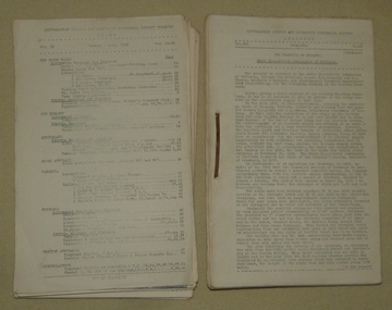
Magazine, Australian Railway and Locomotive Historical Society, "ARLHS Bulletin", 1943
Yields information about the tramways of Bendigo and the Geelong tramways and has a strong association with well known tramway enthusiasts of the era., Yields information about the tramways of Bendigo and the Geelong tramways and has a strong association with well known tramway enthusiasts of the era.Set of 12 Australian Railway and Locomotive Historical Society Bulletins for the period Jan 1943 to December 1943. Each page has been stencil duplicated. Index sheets for the journals at the front of the documents. March 1943 - pages 29 to 32 has an article "The Tramways of Bendigo - Bendigo Tramway Company Limited" written by Wal Jack. Has a large full page map prepared by C. C. Singleton. March 1943 - page 40 - has a short item on the St Kilda Brighton Tramway - three new tramcars (VR type). Item from the Journal of Victorian Model Railway Society" July 1943 - page 1 to 4, has an article "The Tramways of Geelong" - author not given, though probably largely Wal Jack. Has a large full page map prepared by C. C. Singleton. The Jan to June issues are loose, while the July to December issues have been hole punched and held together with a metal binder.museums bendigo, vr trams, geelong -
 Ballarat Tramway Museum
Magazine, Australian Railway and Locomotive Historical Society, "ARLHS Bulletin", 1945
Set of 12 Australian Railway and Locomotive Historical Society Bulletins for the period Jan 1945 to December 1945. Each page has been stencil duplicated. Index sheets for the journals at the front of the documents. Pages 1, 2, 32, 35, 50, 62 and 69, on the Elsternwick Horse Lines, Kew Horse Line and the Prahran and Malvern Tramways Trust, including a map on page 35, but pages 31 to 35 have been removed as has pages 62 to 65. All issues are contained loose within a fly sheet from a spring back binder.museums railways, tramways -
 Ballarat Tramway Museum
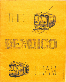
Book, Written by A. Weston and typed by Geoff Clark, "The Bendigo Tram", 1971
Produced by the North Sydney Boys High School Railway club, prior to the closure of the Bendigo system - little else written and published at the time about the history and details of the system. A very good booklet for the time - produced entirely by the wax cut stencil process. Has a strong association with the people who prepared the document. Lower significance as not directly associated with Ballarat.Twenty page booklet on the history, operation and tramcars of Bendigo, produced by the Nth Sydney Boys High School Railway Club in September 1971. Printed on a wax cut stencil process, with green covers, drawings, maps, track layout, fleet list, gives tentative closure dates, route descriptions, sketches, stapled on edge. Title "The Bendigo Tram". Inside front cover notes written by A. Weston and typed by Geoff Clark. See Reg item 302 for the Ballarat version.trams, tramways, bendigo -
 Ballarat Tramway Museum
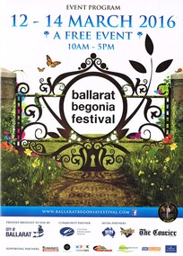
Programme, Begonia Festival, Begonia Festival program, Feb. 2016
Full colour, A4 foldout, 8 parts, printed onto an A2 sheet, Begonia Festival program, for the 2016 Begonia Festival. Has a map with Wendouree Parade in the gardens area and shows the tram track and depot. Also shows the Park & Ride area in Victoria Park and notes the bus service from the railway (train station). Two copies held.trams, tramways, begonia festival, festival program -
 Ballarat Tramway Museum
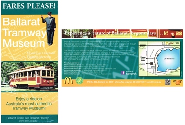
Pamphlet, Ballarat Tramway Museum (BTM), "Fares Please! / Ballarat Vintage Tramway", Jun. 2014
Printed single sheet pamphlet, advertising BTM Vintage Tramway, titled "Fares Please!" featuring Frank Puls, a 1/- ticket and tram 26 on one side, map, details and McDonalds Wendouree on reverse. Printed in green, orange and black and white on light art paper. Includes BTM web address and McDonald's logo on rear, giving five locations of McDonalds, including the Western Highway at Ballan, Tourism and Museum Accreditation logos Introduced late June 2014. The 2014 version has the web address on the bottom edge of the front, Facebook logo and QR code on the rear. Map revised to include Wendouree Railway Station, Care, and the POW Memorial. See Reg Item 2443 and 4453 for previous versionstrams, tramways, mcdonalds, btm, ballarat vintage tramway, botanical gardens -
 Ballarat Tramway Museum
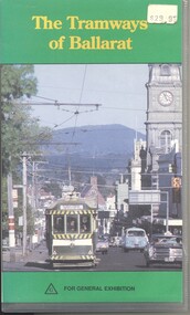
Film - Video cassette tape and box, Ballarat Tramway Preservation Society (BTPS), "The Tramways of Ballarat", 1993
Yields information about the Ballarat Tramway system through historic film collected by the BTPS and made into a Video tape. Has a strong association with those who provide the film, for example Bob Prentice and others.Video cassette tape and box with cover containing the video titled ""The Tramways of Ballarat" produced by the BTPS in 1993. The contents of this tape were subsequently used to make the DVD. Over a 1000 copies distributed. Material from BTV 6 used in the production. See rear cover for details of those whose film was used. Cover Photo Glen Mills, Script Richard Gilbert, Narration Bruce McLean and Produced by John Phillips and Richard Gilbert. Inside of the cassette paper cover is a map of the system. Produced by the Association of Railway Enthusiasts on behalf of the BTPS. Cost at the time $29.95, price sticker remains.ballarat, films, tv broadcasts, btv -
 Otway Districts Historical Society
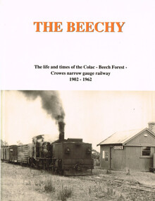
Book, The Beechy, 1992
The Beechy. The life and times of the Colac-Beech Forest-Crowes narrow gauge railway, 1902-1962; Norman Houghton; hard cover; viii, 176 p.; illus., maps; ISBN 0909340 28 5Printing - McPherson's Printing Group; Typesetting - Mackenzies Typesetting.the beechy; colac; beech forest; crowes; narrow gauge railway; norman houghton; locomotive operations; traffic; timber tramways; otway people; the garrett; trolley traffic; lean 1930s; -
 Otway Districts Historical Society
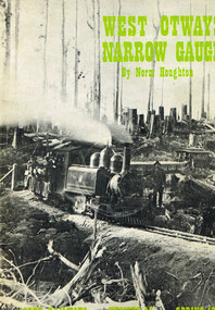
Book, West Otways Narrow Gauge; Norman Houghton, Spring 1973
West Otways Narrow Gauge; The story of the Beech Forest 2ft 6in gauge railway and its connecting tramways; Norman Houghton; Light Railways v.XII, no.45, Spring 1973; soft cover; 52p.; illus. mapsPrinting - Kemera Press, Caulfield, Vic.west otways; narrow gauge; beech forest; 2ft 6in narrow gauge; tramways; colac; gellibrand; the ridge; crowes; -
 Otway Districts Historical Society
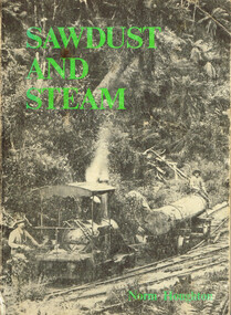
Book, Light Railway Research Society of Australia, Sawdust and Steam. Norman Houghton, December 1975
Sawdust and steam. A history of the railways and tramways of the eastern Otway Ranges. Norman Houghton. IBSN 0 909340 03 X. Soft cover. iv, 106 p.; illus, maps. Melbourne, 1975. Cartography: Alan Strempel.steam and society; norman houghton; railways, east otways; tramways, east otways; tramways, forrest; coastal tramways; -
 Otway Districts Historical Society
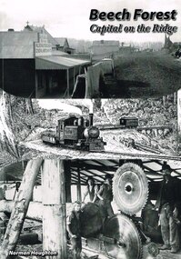
Book, Norman Houghton, Beech Forest: Capital on the Ridge. Norman Houghton, 2008
Beech Forest: capital on The Ridge. Norman Houghton. 1st ed. reprinted. Geelong (Vic.); Norman Houghton; 2007. iv, 112 p.; illus, maps. Soft cover. beech forest; the ridge; norman houghton; roads; railway; bushfires; weather; governance; commercial life; timber; agriculture; education; churches; sports; -
 Otway Districts Historical Society
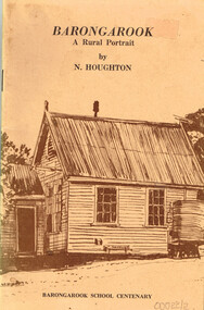
Book, Barongarook School Centenary Committee, Barongarook: a rural portrait. Norman Houghton, 1979
Barongarook: a rural portrait. Norman Houghton. John Reid (illus.) Robert Ashley (cart.) 1st ed. Barongarook School Centenary Committee; Barongarook (Vic.); 1979. 52 p.; illus, maps. Soft cover. ISBN 0 9596142 0 6barongarook; norman houghton; john reid; robert ashley; housing; schools; commercial premises; railway; roads; timber; minerals; social history; -
 Otway Districts Historical Society
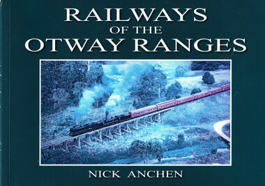
Book, Railways of the Otway Ranges, 2011
After various railways into the Otways were proposedfour separate lines were built, a crucial ingredient of the timber industry. It eventually expanded to become of the Victoria's largest.Railways of the Otways. Nick Anchen. Sierra Publishing; Ferntree Gully (Vic); 2011. ii, 96p.; illus, maps. Soft cover. ISBN 978 0 9807640 0 0.railways of the otway ranges; nick anchen; history; railways; otways; otway ranges; logging railroads; railroads, industrial; -
 Otway Districts Historical Society
Book, Train Hobby Publications, Victorian Railways Narrow Gauge, Part 2, March 1999
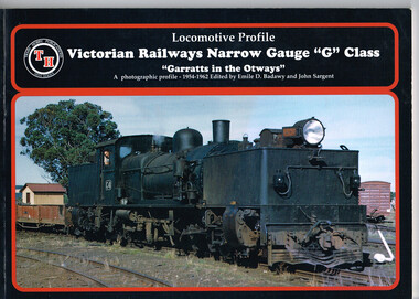
... Forest; Crowes; Garratt; Victorian Railways; narrow gauge; Emile ...An historical series setting out Garratt engines and running stock running between Colac and Crowes (just past Lavers Hill), and then between Colac and Beech Forest in the Otways between 1958 and 1962 when the line closed.Victorian Railways Narrow Gauge "G" Class. "Garratts in the Otways" Part Two. A photographic profile - 1958-1962. Emile D. Badawy (ed.); John Sargent (ed.). 1999; Train Hobby Publications. ii, 56 p.; illus., map. Soft cover. colac; beech forest; crowes; garratt; victorian railways; narrow gauge; emile d. badawy; john sargent; -
 Otway Districts Historical Society
Book, Train Hobby Publications, Victorian Railways Narrow Gauge, Part 1, March 1998
... the Victorian Railway narrow gauge line from Colac to Crowes ...The first in an historical series showing the Victorian Railway narrow gauge line from Colac to Crowes, and then from Colac to Beech Forest, in the Otways from 1954 until 1962 when the line closed.Victorian Railways Narrow Gauge "G" Class. "Garratts in the Otways" Part One. A photographic profile - 1954-1962. Emile D. Badawy (ed.); John Sargent (ed.). 1998; Train Hobby Publications; Studfield (Vic). ii, 48 p.; illus., maps. Soft cover.colac; beech forest; crowes; victorian railways; garratt; narrow gauge; emile d. badawy; john sargent; -
 Otway Districts Historical Society
Book, Puffing Billy Preservation Society, Focus on Beech Forest Line, Part One, January 2004
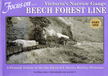
In the earliest years of the Colac-Beech Forest-Crowes line all trains were hauled by NA-class 2-6-2 tank locomotives. From 1926, with the introduction of articulated Beyer Garrett locomotive G41, it hauled the majority of trains with the NAs providing supplementary service as required. Late in 1945 Garratt G41 was again out of action undergoing repairs at the depot in Colac so regular traffic again was handled by an NA for a short time. The line continued to survive on pulpwood long after other VR narrow gauge lines had ceased operation but finally, on 30 June 1962, a dilapidated G42 hauled the last train of goods wagons and vans to Beech Forest and return.Focus on Victoria's Narrow Gauge: Beech Forest Line, Part One. John E. Thompson. Puffing Billy Preservation Society; Belgrave (Vic); Jan 2004. vi, 42 p.; illus; maps. Soft cover. ISBN 0 9579792 4 Xvictorian railways; narrow gauge; beech forest; colac; crowes; edward a. downs; john e. thompson; -
 Otway Districts Historical Society
Book, Focus on Beech Forest Line, Part Two, November 2006
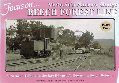
In the earliest years of the Colac-Beech Forest-Crowes line all trains were hauled by NA-class 2-6-2 tank locomotives. From 1926, with the introduction of articulated Beyer Garrat locomotive G41, it hauled the majority of trains with the NA-class providing supplementary service as required. Late in 1945 G41 was out of action undergoing repairs at the depot in Colac so regular traffic again was handled by an NA-class for a short time before the Garratt returned. After this the line survived on pulpwood traffic long after the other narrow gauge lines had ceased regular operation until, on 30 June 1962, a dilapated G42 Garrett hauled the last train of goods wagons and vans to Beech Forest and return.Focus on Victoria's Narrow Gauge Beech Forest Line, Part Two. A pictorial tribute to the late Edward A. Downs, Railway Historian. John E. Thompson. Puffing Billy Preservation Society; Belgrave (Vic); November 2006. iv, 42 p.; illus; maps. Soft cover. ISBN 0 9579792 6 6victorian railways; narrow gauge; beech forest; colac; crowes; john e. thompson; edward a. downs; railway; -
 Otway Districts Historical Society
Book, Puffing Billy Preservation Society, G42: Puffing Billy's Big Brother, 1981
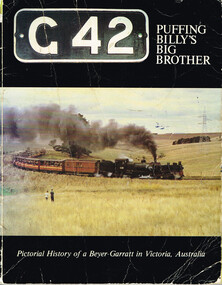
Victoria's narrow gauge railways were from Wangaratta to Whitfield (covering 30.5 miles/49 km) opening in 1899, Colac to Beech Forest (29 miles/46.7 km) opening in 1902 with an addition to Crowes (14.1 miles/22.7 km) opening in 1910, Upper Ferntree Gully to Gembrook (18.2 miles/29.3 km) opening in 1900, and Moe to Walhalla (26 miles/41.3 km) opening in 1910. From the outset these narrow gauge lines proved very uneconomical in operation and were plagued with continuing financial losses. The lines most difficult to work were those carrying the most business, and in particular the trains from Colac and Moe with their 1 in 30 grades and countless curves precluded having engines with large coupled driving wheels operating. Having examined the possible use of articulated locomotives to reduce operating costs on the narrow gauge lines the Victorian Railways decided upon the Beyer-Garratt type of locomotive in 1925 and an order was placed in England for two engines of the 2-6-0 plus 0-6-2 wheel arrangements. These arrived in April 1926. Assembly of the new Garratts was duly completed and steaming trials carried out at Newport, Victoria, the engines being classed as "G" and given the running numbers "41" and "42". G41 was taken to Colac where, on 5 June 1926, it was put to work on the Colac-Beech Forest-Crowes line. G42 soon followed and duly began work on the equally steep and tortuous but shorter Moe-Walhalla line. Following the closure of the Moe line in 1955 G42 was refurbished and went to Colac. G41 was overhauled, but not as thoroughly as G42, at then returned to Colac where both Garratts shared regular work on the line until its closure in 1962. From 1978 G42 continues its operation on the Upper Ferntree Gully-Gembrook line as part of the Puffing Billy Preservation Society.G42: Puffing Billy's Big Brother. Pictorial history of a Beyer-Garratt in Victoria, Australia. Phil A'Vard, Larry James, Ron Peach (concept). Puffing Billy Preservation Society; Belgrave (Vic); 1980. 64 p.; illus; map. Soft cover. ISBN 0 9598392 7 5victorian railways; narrow gauge; moe; walhalla; colac; beech forest; crowes; upper ferntree gully; gembrook; beyer-garratt; -
 Otway Districts Historical Society
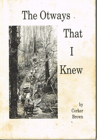
Book, Merimbula Easiprint, The Otways that I knew, 1993
Condensing 100 years of Otway history the author tries to give an insight into the thoughts and ways of the settlers in opening the western Otway Ranges. It gives some indication of the mental pressure, hand-in-hand with the physical stress, as a settler cleared the land and made a living for his family. It covers how the rail link brought in the timber mills and their workers which made timber the main industry of that era, and covers the changes that took place in the 1930s as the mills closed down and the district raised crops, dairying and grazing.The Otways that I knew. Ronald Charles 'Corker' Brown. 1st ed. Corker Brown; np; 1993. 216 p.; illus; maps. Soft cover. ISBN 0 646 16798 7otway ranges; corker brown; otway lighthouse; aborigines; beech forest; farming; grazing; crops; railways; roads; timber; -
 Otway Districts Historical Society
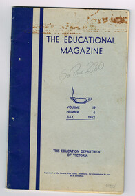
Periodical, Education Department, Victoria, The Education Magazine, Vol.19 No. 6, July 1962
The Educational Magazine is a monthly magazine of educational articles, Australian and overseas, published for teachers by the Education Department of Victoria. Vol.19, No. 6 contains one article of particular relevance, A Train and History, written by Frank McCabe. The Educational Magazine, Volume 19, Number 6, July 1962. The Education Department of Victoria; Melbourne (Vic); 1962. 47 p.; illus, map. Soft cover.education; magazine; railways; articles; history; -
 Otway Districts Historical Society
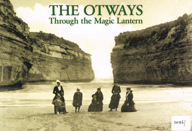
Book, Colac and District Historical Society, The Otways through the magic lantern, 2013
George Sydenham was appointed as Colac Shire Valuer and rate collector in 1890 which threw him into direct contact with the Otway people at a time when the first selectors were suffering badly. He would have heard their frustrations and grievances in great detail. When Secretary to the Colac Committee for the Railway Extension to Beech Forest he used his magic lantern slide shows from 1896 to support his case for a railway, by lauding the place and its potential, both for settlement and for timber production.The Otways through the magic lantern: commentary and glass slides of George Sydenham - lecture held in 1896. George Francis Sydenham. 1st ed. Colac (Vic); Colac and District Historical Society; 2013. iv, 118 p.; illus., map. ISBN 9780 6469 122 02 Soft cover.colac: otway ranges; history; coasts; -
 Otway Districts Historical Society
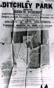
Photograph, Knox Collection, Sale of the Ditchley Park Estate, Beech Forest, 1908
Commercial realities and bushfires caused the Beech Forest community to re-establish itself around the railway station, away from Gardner Hill. This caused John W. Gardner to subdivide his land on the north side of the railway station. One subdivision was created near the Ditchley railway station on the old racecourse site, and another of 25 allotments forming what became Southorn Street. There were very few takers for these lots nor any buyers for the Ditchley subdivision.Photocopy. 260mm x 159mm. An advertisement for the sale of the Ditchley Park Estate, Beech Forest. Under instructions from Mr. J.W. Gardner Dalgety & Co. Ltd. will sell the subdivision of the Ditchley Park Estate on Tuesday, March 30, 1909, at 2 o'clock. A map of Beech Forest township and the Ditchley Park Estate is attached, as are the terms of sale and a description of the area.. beech forest; ditchley park; land sale; advertisment; -
 Otway Districts Historical Society
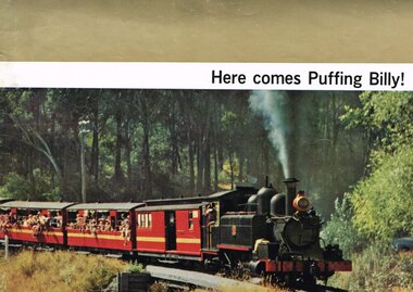
Book, Puffing Billy Preservation Society, Here comes Puffing Billy!
The Puffing Billy Preservation Society came into existence by a popular desire to retain something of our narrow gauge railway past, leisurely in this age but a boon to the sparsely settled areas it served in the past. It served the Wangaratta-Whitefield line, the Upper Ferntree Gully-Gembrook line, the Colac-Beech Forest-Crowes line, and the Moe-Walhalla line, the last railway line served being the Colac-Beech Forest line. None of these railways were a paying proposition but they played an important part in the areas they served. Nowadays, the last bit of line is a portion of the Upper Ferntree Gully-Gembrook line, from Belgrave to Lakeside, run by the Society. The Engine Shed has several small NA-class locomotives with NBH excursion carriages, and at the moment the Garratt G class in pieces. Here comes Puffing Billy! Puffing Billy Preservation Society; Belgrave (Vic); nd (after Aug. 1962). 18 p.; illus., maps. Soft cover.puffing billy preservation society; railways; wangaratta; whitefield; upper frentree gully; gembrook; colac; beech forest; crowes; moe; walhalla; -
 Otway Districts Historical Society
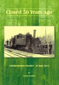
Book, Closed 50 Years Ago. Norman Houghton, 2012
June 2012 represented 50 years since the Colac to Beech Forest to Weeaproinah narrow guage railway was closed. The last goods train ran on 27 June 1962, and the last passenger excursion train on 30 June 1962. The railway was the lifeblood of the West Otways for several decades, enabling farmers and saw millers to bring into economic production the natural wealth of the region. Timber, butter, wool, livestock, potatoes, fodder and minerals flowed out for the benefit of Victorian consumers.Closed 50 years ago. The Colac to Beech Forest narrow guage railway. Commemorative booklet - 30 June 2012. Norman Houghton. Norman Houghton; Geelong (Vic); 2012. iv, 52 p.; illus., maps. Soft cover.colac; beech forest; weeaproinah; railway; -
 Bendigo Historical Society Inc.
Document - MARKS COLLECTION: BOUNDY'S FREEHOLD GOLD MINES MALMSBURY
Plan/advertisement 1888 for the sale of the Boundy's Freehold Gold Mines Malmsbury, 260 acres of auriferous and arable freehold land. Document contains map of mines, names include O'Connors Freehold Company, Egyptian Company, Queen's Birthday Company, No.1 South Queen Company, Madam O'Connor's company, Extended South Queen's Birthday Company. Scale 10 chains to one inch. Taken from Mr. H. Archdale's Plan by Walter Sleeman, Mining Mgr., Oct 9th. 1888. On RH side of map Daylesford Road to Malmsbury marked. The land is only about two miles from the Malmsbury railway station. On back of document letter from Henry Nutman, Mining Manager, Queens Birthday Company; Report on Plan Walter Skleeman, M.M.; letter to S. Deeble, 35 Queen St., Melbourne with report on mine from George Jenkyn and Mining Manager's Report in Argus 24th.October, 1888.mine, gold, boundy's freehold gold mine -
 Ballarat Tramway Museum
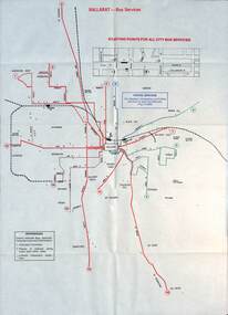
Map - Public Transport Map - Bus, Ministry of Transport, Ballarat, Bendigo & Geelong, 1977
... Ballarat Bendigo Geelong timetables railways On each map "7/77 ...Set of three maps, c1977 show the bus routes for each of Ballarat, Bendigo and Geelong along with railways. Provides information on each route, summary timetables, who operated the route and places of interest. Published by the Ministry of Transport in conjunction with the Transport Regulation Board, Bus Proprietors Association and VicRail. By comparison with the posters issued at the time of tram closure, can see the changes made to the routes in each city. See item 6813 for Ballarat, 6812 for Geelong, and 6814 for Bendigo.Demonstrates a public transport map published by the Ministry of Transport.Set of three 10 fold maps printed in colour to pocket size.On each map "7/77" in ink.buses, maps, ballarat, bendigo, geelong, timetables, railways -
 Bayside Gallery - Bayside City Council Art & Heritage Collection
Map, Department of Crown Lands and Survey et al, Moorabbin, County of Bourke, Government Roads, 1920
The cadastral map of the Parish of Moorabbin in Victoria (L.6104) shows parish boundaries and land ownership 1920 when Sandringham was a Town. The government roads have been coloured in red pencil.moorabbin, county of bourke, map, plan, land subdivision, land titles, foreshores, hampton, beaumaris, highett, cheltenham, department of lands and survey, land owners, cartographic material, brighton, sandringham, town of sandringham, government roads -
 Bayside Gallery - Bayside City Council Art & Heritage Collection
Map - print, Melbourne and Metropolitan Board of Works, Interim development order: Brighton, Moorabbin and Sandringham, 1959
The Melbourne and Metropolitan Board of Works (now Melbourne Water) was established in 1891. From that time, as part of their work laying water and sewerage connections, they created detailed plans of houses and other buildings in the Melbourne metropolitan area. In 1956 it acquired powers to construct and maintain highways and bridges, protect and improve the foreshores and create and maintain parks within the metropolitan region. This Interim development order comprises part of the municipalities of Brighton, Moorabbin and Sandringham and was made on 20 October 1959.brighton, moorabbin, sandringham, melbourne and metropolitan board of works, map, town planning, cartographic material, interim development order, bayside -
 Bayside Gallery - Bayside City Council Art & Heritage Collection
Map, Department of Crown Lands and Survey, Moorabbin, County of Bourke, c. 1918
The cadastral map of the Parish of Moorabbin in Victoria (L.6104) shows parish boundaries and land ownership c. 1918 when Sandringham was a Borough.moorabbin, county of bourke, map, plan, land subdivision, land titles, foreshores, sndringham, hampton, beaumaris, highett, cheltenham, department of lands and survey, land owners, cartographic material, borough of sandringham, brighton -
 Bayside Gallery - Bayside City Council Art & Heritage Collection
Map, Department of Crown Lands and Survey, Melbourne and Suburbs, City of Sandringham, 1917-1926
map, plan, foreshores, sndringham, hampton, beaumaris, cheltenham, department of lands and survey, cartographic material, borough of sandringham, moorabbin, black rock, street map, city of sandringham -
 Bendigo Historical Society Inc.
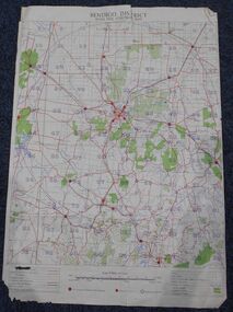
Map - Bush Fire Control Map Bendigo District
... Cream coloured parchment map showing roads, railway lines... A Bush Fire Control map is a valuable tool used by emergency ...A Bush Fire Control map is a valuable tool used by emergency services and communities to respond to respond to bushfires.Cream coloured parchment map showing roads, railway lines, telephone lines, rivers, creeks and water courses. Also marked are houses, Post Offices, Police stations, bush fire brigades, water channels, swamps, marshes, dense, medium and scattered timber, aqueducts and reservoirs. Villages, districts and Towns are clearly marked. Printed in red, green, black and blue. Very clear and easy to read. Undated.bush fires, bendigo area map