Showing 1203 items matching "bourke street"
-
 Sunbury Family History and Heritage Society Inc.
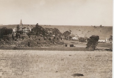
Photograph, 'Rupertswood', 17 March 1934
'Rupertswood' mansion, in Sunbury, was the former home of Sir Rupert Clarke. His original estate covered 137317 acres in various areas in the district of Bourke in the 1880s. The 'Rupertwood' property was eventually acquired by the Salesian Order and functioned as a boys' school where many were trained in farming skills. In the 1990s it became a coeducational secondary college. The Clarke family acquired and settled much land in the Sunbury area and today 'Rupertswood' Mansion is one of the surviving grand nineteenth century mansions in Victoria. The Catholic Church has also played a prominent role in educating many of the young people in the district. A sepia photograph of the 'Rupertswood' mansion set on a rise with surrounding farmland and some outbuildings.rupertswood mansion, salesian college, catholic church, catholic education, education, schools -
 Surrey Hills Historical Society Collection
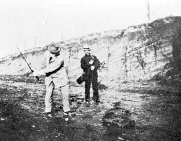
Photograph, Surrey Hills Golf Club - the cutting in (now) Whitehorse Road, 1905, 1905
Reproduced by permission of Mr John Arnold from his book: "The Riversdale Golf Club - a history, 1892-1977." Copyright to book: Riversdale Golf Club. Surrey Hills Golf Club operated from 1892-1908 then moved and became Riversdale Golf Club. The game was played across paddocks from Trafalgar Street, Mont Albert to Whitehorse Road and down Victoria Crescent to where Box Hill TAFE is now located in Elgar Road. There were problems with cows eating the tee flags! The clubhouse still exists as 30 Trafalgar Street. The men are standing on what is now Whitehorse Road in the cutting which can still be seen near the Box Hill Motel. Walter John Carre Riddell: Born c1859; died 12 March 1930; unmarried. Father came from Riddell in Scotland and took up land at Riddell's Creek, near Gisborne. W J Carre Riddell was educated at Melbourne Grammar, graduated in law from Melbourne University in 1882 and practised law until 1907. MLA for West Bourke for 17 years. Chairman of MMBW from 1907 until retirement in 1927. Versatile sportsman. REF: Obituary in Trove - The Argus, 13 March, 1930, p8.The image is significant for its association with Walter John Carre Riddell who was a significant identity in early 20th century Melbourne. His was well-known for his sporting prowess. In early life he was a keen footballer, cricketer and tennis player. In his later years he took up golf. Was President of Royal Melbourne Golf Club and Chairman of the Victorian Golf Association. The 'coffin hole' was a notoriously difficult position to play out from.Black and white photo of 2 men, one swinging his golf club; the other carrying a golf bag and watching. They are dressed in suits and hats and are standing in a cutting, the face of which shows rock strata."W. J. Carre Riddell playing out of the coffin, 1905."sports grounds, surrey hills golf club, riversdale golf club, jon arnold, w j carre-riddell, walter john carre riddell -
 Port Fairy Historical Society Museum and Archives
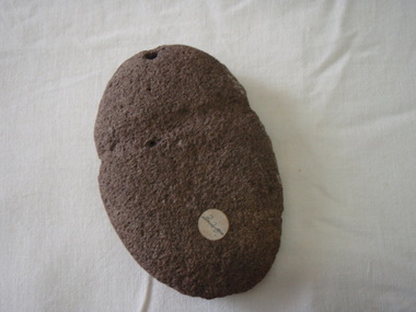
Tool - axe head
aboriginal stone axe head found on Jack Bourke's property (Albert Road) January 1972Stone axe head. Hole at one end and groove made for twinelocal history, ethnographic material, hunting, fishing, gathering, stone, aboriginal -
 Port Fairy Historical Society Museum and Archives
Photograph, Allen Farrow
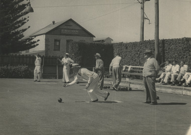
Men playing Bowls on the green on the greens on the corner of Gipps and Bank StreetPhotograph of a sports ground that no longer exists on the corner of Gipps and Bank StreetBlack and white photograph of bowlers on the green on the corner of Gipps and Bank StreetOn back of photograph. Port Fairy Bowling Green. Building, Haylocks Carriage, Gobles Mill. S Brown, (Dake) Malone ? on back of photograph. Allen Farrow, 366 Bourke St, MU3422, Melbourne. For re-ordering please quote No 15 bowls, gipps street, bank street, bowling club -
 University of Melbourne, Burnley Campus Archives
Plan, [Historical Maps of Richmond Park], 1862-2000
(1) Proposed reserve for Horticultural & Experimental Garden in the Survey paddock Richmond. R.19A (1865). Shows Swan Street Extension. Gazettals 1877, 1887. (2) As (1). Half of map only Annotation by A. Purchas, 9 October, 1862. (3) Plan of Richmond park. A.L. Martin Authorised Surveyor, 31st August, 1872. [Dept. of lands & Survey Melbourne, J. Noone, 6th September 1872.] Map in 4 sheets. (4) Richmond Park. Surveyed by Geo. Black, Authorised Surveyor 13.8.91 (2 copies). (5) [Richmond Park] Shows road alignments gazetted 1871 & 1881 (part copy only - Neg. 18375). (6) City of Richmond Parish of Jika Jika County of Bourke. Department of lands & Survey, 1919 (annotations i.e. Melb. City Link, Amrad, etc. to 1994.) (7) Burnley gardens, 2000. Produced by P. Tulk, Institute of Land & Food Resources, Burnley College, 2000 (re area proposed for heritage listing.)richmond park, survey paddock -
 Public Record Office Victoria
Correspondence, 1854
VA 856 Colonial Secretary's OfficeEureka Stockade:Catholics protest over the treatment of Smyth's servanttrial, catholic, protest, maltreatment, johannes gregorious, james lord, timothy hayes, charles hotham, michael bourke, timothy shanahan, patrick curtain, michael quinlan, john hynes, john manning -
 Port Fairy Historical Society Museum and Archives
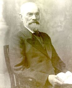
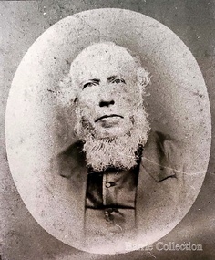
Photograph, Cornelius Bourke Mayor 1906
Cornelius Bourke Mayor 1906Black and white photographbelfast, mayor, portrait, government, shire, council, municipal, local-government -
 Melton City Libraries
Map, Streets of Melton, 1963
MELTON’S STREETS Heritage Week 2014 What’s in a Name? Alphabetical List Aboriginal place names, Early Family Names and landowners, Agricultural, Shop and Commercial premises, Places and Events Melton & District Historical Society Street Naming Project 1972 – c 1998 Suburb Name – KURUNJANG - Kirkton, 1972, Brookfield, West, 1988 Melton and Town Centre - A joint collaboration with the Shire of Melton and Subdivision Developers ARNOLD Court – Family house - Arnolds Creek ALKEMADE Drive Family – Lime kilns Coimadia ALEXANDRA Street 1902 – Corination of King Edward VII and Queen Alexandra AVIATOR Place Event, location of plane crash – Jimmy Melrose 1936 Adina ?Annibee - Anniba? Agricultural Avon court .. .. BAKERY Square - Location of Jongebloed shop, bakehouse and stables BALUK Place Aboriginal BARLEYCORN Place Agricultural BILLING Place Name of Jimmy Melrose Uncle Noel Pemberton Billing BLACKWOOD Drive - Alexander Blackwood 1860c Registrar BARRIES Road C. E. Barrie “Darlingsford” farmer 1911, chaff mill owner BROOKLYN Road Staughton family residence. 1875 – Dismantled c 193? CAHILL Drive Family - Glenville Dairy CAMERON Court Family Canopus Place ? CANALLAN Drive Early Surveyor CAMPBELL Court Aviation – Melrose passenger 6th July 1936 CARBERRY Drive Michael, early landowner family CAREW Court Edward and Michael. Royal Hotel. Vera (Carew) Forran Singer - Opera CASEY Court Family CASHIN Court Family CHEVIOT Court Agriculture, breed of sheep CHESNEY Road was re named ( Minns Road being duplicated c 1973) CHRISTINA Crescent Christina McPherson, daughter of James and Mary Mary McPherson. Died 1955 aged 85 years COLLYER Close a deleted street (parallel to Yuille) re-used CORRIEDALE Road Breed of sheep CORR Court Teacher at first school, landowner CROXTON Court Name of the Hornbuckle and Knox family home DALEY Court - William Daley and family 1865 Bootmaker High Street DARLINGSFORD Boulevard - Name of early homestead Thomas B Darling 1853 DJERRIWARRH Court - Parish County of Bourke - very early map. DODEMAIDE Place Early land owners - Melton Football Team had 6 brothers playing c 1924 DONALD Court McPherson family 6 generations in Melton in 1936 DOUGAL Court DUNCAN Court .. .. DUNVEGAN Circuit Home of the McPherson family, castle Isle of Skye Name of bluestone house Smith Street (now at Willows) EMIL Court Jongebloed family EXELL Avenue Farming family Melton Sth- Closer Settlement 1907 EXFORD Road Exe former name of the Werribee river FARMER Court Name of early postmistress FERRIS Road John Ferris Farmer HANNAH Close First name of Hannah Watts – midwife HAYBALE Place Agricultural HELDER Court Early surveyor J Helder Wedge map HEWSON Street Winston Hewson Shire Engineer – check title c 1960 HENRY Street Township map c 1860 HESTON Street Heston Phoenix – C.J. Melrose plane HILDEGARDE Court Jimmy Melrose’s mothers name HOMESTEAD Close HORNBUCKLE Cres Farmers. Three members of family - Shire Presidents HURLEY Street Farmers IAIN Court Descendent of James and Mary McPherson JAMES MELROSE Drive Name appears on 2013 Melton information map JANG Place KURUN – jang KIRKTON Drive Name of the McPherson family home Toolern Vale Road KIRWIN Street Michael early landowners (deleted for freeway construction) KILPATRICKS Road Deleted when Barries Road was extended across Station Rd KOROROIT Court Early map, Parish of Kororoit. Creek name KNOX Circuit Family – Hornbuckle “Croxton Park” KURRUNJANG Drive Aboriginal name for people of the red earth – Suburb name Lara Place ? LLOYD Court Garage owners High Street. Laura lived to 100 years D 1955 LUBY Court John Luby – Crown Grant Land Title LITTLE Court MANNING Avenue Richard, hotel owner 1891 MARGARET Drive McPherson family McDONALD Street Melton South family name McKENZIE Street Township c1860 MORROW Street Early name MOWBRAY Crescent Name of English Melton, popularly believed origin of Melton MYERS Court Early setters c 1866 Crown Grant Land Title NIMMO Street Early name NIXON Street Name submitted by Mary nee Nixon Collins c1985 OLDERSHAW Road Early builder PALMERSTON Street Early township map c 1860 PEART Court Early name PENNYROYAL Avenue Plant growing by the creek. Early name used for the Toolern Toolam Creek PINKERTON Street Family name and early street map PINNACLE Crescent Agricultural - type of wheat PHOENIX Circuit C.J. Melrose Phoenix Heston Plane 2013 map PRATT Family PRIOR Court PYKE Place Brothers – early settlement 1838 RADFORD Court Land owners and business operators. Former Royal Hotel Grocer High Street demolished 1970 RAGLAN Court Hotel 19th century Lord Raglan RALEIGHS Road Oliver Reierson family (Norweigen) Shopkeeper – Dressmakers RIDDELL Drive (misspelt Riddle) Resident and land owner RODERICK Road McPherson family – a re occurring name ROLLAND Court Jones family ROSS Court Daniel. Landowner. Agnes Ross music teacher RUSSELL Court Robert. Early land surveyor of Melton 1853 RYAN Court Family early landowner. Member of the 1862 Road Board SHEBLER Place Augustus early Melton resident – Golden Fleece Hotel SHEEPFOLD Court Farming SHERWIN Court Sherwin Street earliest Township map– became Golf course SMITH Street Early township map. STRATHULLOH Circuit Strathtulloh Homestead. STAUGHTON Street Family – LARGE land owners Strachan ? SWANEY Court Marie Swaney earlier resident of Strathtulloh. SUTHERLAND Family name TOOLERN Street TOOLAM – TOOLERN Creek TULLIDGE St Road marked on 1861 map UNITT Street Early Township c 1860 WALLACE Square Cr Jack Wallace 5 terms as President 46 years unopposed WATTS Court Hannah Watts – midwife, cottage hospital WALSINGHAM Name of house of Minns family. From Walsingham Norfolk England WESTLEY Place Name of Jimmy Melrose Percival Gull Plane WESTLAKE Drive Early resident WHICKHAM Street Family Name Melton South WILSON Road Albert, Melton South YUILLE Street William Cross, early landowner, Rockbank run Zoomed in section of Melton Streets including Church and High Streetlandscapes of significance -
 Melton City Libraries
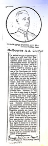
Newspaper, Melbourne A.A. Club, 1903
"Captain Simon Thomas Staughton was the son of Simon Thomas Staughton MLA who had built the mansion Eynesbury on his share of the Exford property inherited from his father Simon Staughton, the original 1840s Werribee River squatter. When the land was sold, Simon’s Exford station extended from Mt Cotterell to the Brisbane Ranges. ST Staughton (senior) was a reputedly the public spirited member of the family in his generation, being a member of the first Roads Board (and Melton Shire President in 1867), a JP, Magistrate and MLA for Bourke from 1883 until his death in 1901, whereupon his son became the MLA for Bourke. Captain ST Staughton had earlier been chosen as a member of a contingent of Victorian Mounted Riflemen sent to England for Queen Victoria’s Diamond Jubilee (1897), and was later a member of King Edward’s coronation escort. In October 1899 he had sailed for South Africa with other Mounted Riflemen from Victorian and NSW to take part in the Boer War. There he was awarded the DSO. He died of peritonitis in 1903, aged 27. He was buried in Boroondara Cemetery after a full military funeral, in which the coffin was borne on a gun carriage drawn by four black horses. All local newspapers reported eloquently on the funeral, and the late Captain’s virtues. The Staughton Memorial Lamp was given to the town by his young widow in 1903. In addition a window in the (former) Christ Church bore the inscription ‘This window is erected by his brother soldiers in loving memory of Captain S Tom Staughton, DSO, ADC, MLA’. The Staughton family had been prominent benefactors of the Church, whose altar rails were also inscribed to the much respected Captain, along with a memorial stone in the new chancel. In the 1970s the memorial was within one of four fenced tree plantations, probably erected and planted in the 1920s or 30s. When High Street and its service roads were redesigned in the 1970s the plantations were completely removed, and the Melton and District Historical Society was successful in having the memorial moved about 50 metres east to its present location". The Weekly Times article about a gift from Tom Staughtonlocal identities -
 Melton City Libraries
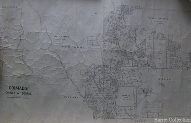
Map, Coimadai County of Bourke, 1911
Town Plan of Meltoncouncil -
 Kilmore Historical Society
MAINTENANCE CUSTODY AND ADOPTION LAW, Butterworths, Maintenance Custody and Adoption Law, 1967
Second Edition Red leather-bound hardcover book, green band with gilt print on spine. Faded patch upper spine and back cover. 378 pp. Good condition.Front flyleaf, oval shaped stamp, '11 NOV 1969/PJL'. Stamp below, 'Clerk of Petty sessions/KILMORE'.maintenance, custody, adoption, law -
 Kilmore Historical Society
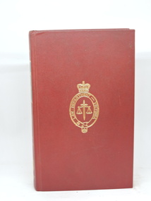
POLICE AND SUMMARY OFFENCES, Victoria. Bourkes Police and Summary Offences, 1970
Second Edition of 'Bourke's Police Offences'.Black paper on board hardcover book. Red band on spine with gilt lettering. 468 pp. Good condition.Stamps on front flyleaf, 'The Clerk of the Magistrates Court/Kilmore'. 'Law Department Victoria'. Stamp on half-title page, 'The Clerk of the Magistrates' Court'.police, offences, kilmore court house library -
 Melton City Libraries
Photograph, Revenant James Lambie, Unknown
Photo is from Werribee District Historical Society and Susan Oliver, descendent of Lambie. Information from Alec Cameron: July 28th Alec Cameron article Late Rev James Lambie came to Melton in 1863 from Paisley, Scotland. He was married the second time. By the first marriage he had one son and two daughters. By the second marriage, one son and three daughters. The second son was Mr William John Lambie. When Rev Mr Lambie took charge of the Presbyterian church it was held in a wooden building. He was a good preacher. He and his family took great interest and commenced to form a committee to collect funds to build a new bluestone church. The collected the rent money for the building. Mr Lambie lived for several years in Melton before he went to Wyndham Church to take charge there, and the family went to live there also. The reason was that the Melton Congregation could not provide the stipend he required. He came from Wyndham on a Saturday and preached to the congregation on Sunday morning and then went back to Wyndham to continue his services in the afternoon and evening. After a few years, Rev Lambie retired from the ministry and purchased a house in South Yarra where he and Mrs Lambie died. The eldest daughter Jessie, married James Scott a teacher at the Melton School. They left Melton and while teaching near Melbourne he got his BA and other degrees. He then purchased the Warnambool College for L5000 and resided there for a number of years. His wife predeceased him. There were two sons and two daughters. He was a brother-in-law of the late Mr Lang wine and spirit merchant Collins street, who was the Mayor of the City Council. His brother Mr Robert Scott was the licensee of the hotel at the corner of Bourke and Russell St and one of Mr Scott’s daughters married Mr Smith, solicitor, a nephew of the late Mr Smith of Toolern Vale, and another one married Dr Officer of Warnambool. They went to Western Australia to reside and Mr J Scott with them. He died abour 6 years ago. Miss Lambie the second eldest daughter, married Mr Samual McDonald, JP, butcher and Clerk of Courts, Melton and late correspondent for the Bacchus Marsh Express. He also acted as the Shire Secretary for the Melton Shire, and got an auctioneer’s license while here. He then left Melton to go to Shepparton, where he became the President of the Shire and the Clerk of Courts. Before he left Melton he was presented with a purse of sovereigns from the residents. The late Mr Lethbridge, Shire, was chairman. Mr McDonald left Shepparton and went to reside at Warnambool and is still living there. He had two sons in the bank. His wife died a few months ago at Boxhill, at the nursing home of her daughter, Sister Jessie McDonald, who was peronsally invested with the Royal Red Cross by the King a Buckingham Palace, for good work done at the front in the recent Great War. Mr William John Lambie, a brother was war correspondent for the “Age”in the South African war, where he was killed. The “Age” proprietary gave a shield in his memory to be shot for the Williamstown rifle competitions, called the Lambie Shield. The last time I was speaking to Mr Donald McDonald, war correspondent for the “Argus” in South Africa he said he thought the next war would be with the whites and the blacks. He said he saw some fine looking well built blacks while he was away. It looks like his words are coming true. Portrait of Revenant James Lambiechurches, local identities -
 St Patrick's Old Collegians Association (SPOCA)
Photograph - SPOCA, 50-Year Closure Event
-
 St Patrick's Old Collegians Association (SPOCA)
Photograph - SPOCA, Annual Dinners
-
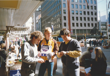 Melbourne Legacy
Photograph - Photo, Legacy Appeal 1989, Selling Badges, 1989
Photos of the Legacy Appeal in 1989 including badge selling and the Army helping out. Three of the photos appeared in the President's Highlights report in 1989. The caption mentions there was an arts and crafts stall run by the widows' clubs in the the City Mall (Bourke St). Also that Hawthorn footballer Peter Curran helped with the badge selling. The Army arrived with a display of vehicles in the city square (corner of Collins and Swanston Sts). A record of fundraising during Legacy Week in 1989.Colour photo x 5 of Army and collectors in Legacy Week 1989.legacy week, badge week, fundraising -
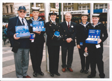 Melbourne Legacy
Photograph - Photo, Legacy Appeal 2004, Selling Badges, September 2004
Photos during Badge Week in September 2004. President George MacKenzie with badge sellers at the Bourke St Mall, some of them in Navy uniforms.A record of the Navy being part of the Legacy Appeal in 2004.Colour photo of the President with badge sellers.Printed on the back "legacy appeal, fundraising, badge week -
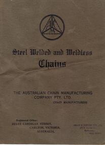 Bendigo Historical Society Inc.
Document - ABBOTT COLLECTION: CHAIN MANUFACTURER CATALOGUE
The Australian Chain Manufacturing Co. was formed in 1933 to acquire the business of Luigi Benini who had started his business in Cardigan Street, Carlton with William Johnson McCredie.Catalogue for steel welded and weldless chains. The Australian Chain Manuacturing Company Pty. Ltd. A light cardboard cover in a green/brown colour. Nine paper pages with lists of costs and illustrations of types of chain. It has two metal staples in the spine. There is an ink stamp on the front cover with a sole agent of Gollin &Company 561/8 Bourke st Melbourne. Printed by The Imperial Press, 678 Elizabeth Street Melbourne in B&W ink. -
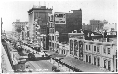 Melbourne Tram Museum
Postcard, Valentine's, "Swanston Street Melbourne", early 1930s
Valentine's postcard titled "Swanston Street Melbourne", Number V49, looking south along Swanston St from Bourke St, Has about 9 W2 class trams in the view. Taken prior to the construction of the Manchester Unity building on the corner of Collins and Swanston Streets. The Capitol building, Cafe Frances, Cann's Ladies Wear, Gasava Health Cooker, Cafe National and Kodak are in the view.Yields information about Elizabeth St, during the early 1930s.Postcard - printed, unused, Valentine Series - with a perforated edge on the left hand side.trams, tramways, swanston st, w2 class -
 Bacchus Marsh & District Historical Society
Map, Village allotments, Parish of Myrniong, County of Bourke
Myrniong is a village 9 kilometers west of Bacchus Marsh. Prior to 1863 the area was known as Blow's Flat. This map which was produced in 1903 and according to the catalogue record of this map held at the State Library of Victoria was based on an earlier map created in 1861. The early layout of streets for the village of Myrniong can be seen on this map. The streets shown are, Main Street, Hardy Street, Blow Street, Myrniong Street, Shuter Street, and Blackwood Street. An area marked as a reserve for a school can be seen between Hardy Street and Main Street.A single page paper map. A cadastral parish map of Myrniong in Victoria, showing numbered land allotments. Photo-lithographed at the Department of Lands & Survey, Melbourne, in 1903. Based on an original map created in 1861. The map is pasted into a bound volume containing 76 maps or plans in total. High resolution digital image stored on BMDHS computer network. Surveyed by John Hardy, Surveyor ; photo-lithographed at the Department of Lands & Survey, Melbourne by T.F. McGauran, 24.12.03myrniong parish plan, myrniong parish maps -
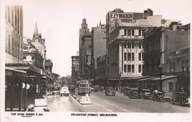 Melbourne Tram Museum
Postcard, Rose Stereograph Co, "Swanston Street Melbourne", early 1940s
Rose Series postcard No. P 564 titled "Swanston Street Melbourne", looking south from Little Bourke St. Has a number of W2 class trams in the view, possibly tram 439 route 15 to St Kilda Beach. Note the Tram Safety Zone with the lamp on the top. In the background are the Ezywalkin, Leviathan, F T Field and Steeles Furniture stores. Foys Department store on the left appears to be having its verandah fitted. Yields information about Swanston St. at the intersection with Little Bourke St.Postcard - printed real photograph with Rose Stereograph Co. name on the rear. Unused.trams, tramways, w2 class, swanston st, tram 439, route 15 -
 Charlton Golden Grains Museum Inc
Photograph, Bourke's Butcher Shop High St Charlton c. 1987, c.1987
Corner of High St and Williams St (now Curtin Dve). Formerly the site of Wingfield's Hides and Wool agent and Frank O'Grady's solicitors office. In 1971 Jim Bannon moved his butcher business from the eastern end of High St to this newly built shop. He sold to Weirs in 1986 who sold to Frank Bourke in 1987. Part of a streetscape series taken for the Shire of Charlton in 1987. Bourke's butchers shop built 1971 for J Bannon. Shows area now occupied by the Travellers Rest complex.Colour photograph of single storey brick building with large glass window and door. Tree in front of building and a man walking past. Two storey white building to the right and a street and old single storey building on the left. Car parked in street on the LH side of the photo. Signage on the old building on the left reads STATES. jim bannon, frank bourke, wingfield's hides, frank o'grady, business, industry, charlton, butcher -
Clunes Museum
Book, Stockland Press, Handbook for Woolgrowers issued by the Australian Wool Board
Handbook for Woolgrowers issued by the Australian Wool BoardBlack leather cover, 88 pages of original text, 2 x brass screws to bind, further pages have been issued by the Wool Board and have been added at a later date. Drench "recipe" for worms in sheep, hand written in black ink, is attached to page 55 by a dressmaker's pin, 2 pages.Handbook for Woolgrowers issued by the Australian Wool Boardaustralian wool board, handbook for wool growers -
![Map, Plan of Subdivision [Allotments along Lerderderg, George and McFarland Streets]](/media/collectors/5e461d8021ea67224c82f2a1/items/675d7243165f146b8adfc656/item-media/675d72d7165f146b8adfc859/item-fit-380x285.jpg) Bacchus Marsh & District Historical Society
Bacchus Marsh & District Historical SocietyMap, Plan of Subdivision [Allotments along Lerderderg, George and McFarland Streets]
This map shows allotments of land on the northern side of Lerderderg Street from Gisborne Road through to the approximate site of the present day Bacchus Marsh Primary School. There are also allotments shown on the southern side of McFarland Street between George Street and Gisborne Road. Larger allotments of land are shown extending northwards towards Masons Lane. Inscribed at the top of the map are the words, 'Plan of Subdivision of Cr Pors (Crown Portions) 12 & 13 & Allotments 1,2,3,4, Block 3, Parish of Korkuperrimul, County of Bourke'. The date of the map has not been established but the absence of the Bacchus Marsh Primary School on the map suggests it may have been produced prior to 1865 when the primary school was built in Lerderderg Street.Single page map showing house block size land allotments in the Lerderderg, George Street and McFarland Street area of Bacchus Marsh with larger allotments north of this area towards Masons Lane also shown. Scale 150 feet to 1 inch. Part of a set of maps which are pasted into a bound volume containing 76 maps or plans in total. High resolution digital image stored on BMDHS computer network. bacchus marsh victoria maps, lerderderg street land allotments, mcfarland street land allotments -
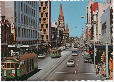 Melbourne Tram Museum
Postcard - Nu-color-Vue, Nucolorvue Publishing, Swanston St looking to the Shrine of Remembrance, Early 1970's
One of a series of postcards produced by Nu-color-vue. Shows Swanston St looking south from Little Bourke St. Has W2 373 (Route 67, Carnegie) and a number of other W2 class trams in the view.Yields information about the appearance of Swanston St in the early 1970's and the nature of tramway operations in the street.Postcard - Nu-color-Vue - serrated edges looking south along Swanston St towards the Shrine of Remembrance - ML144swantson st, w2 class, nucolorvue, postcard, souvenir, tram 373, tramways, trams, shrine -
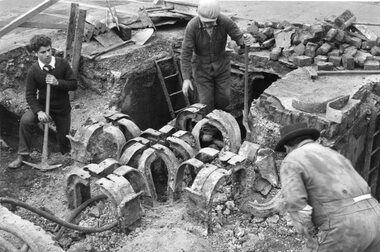 Melbourne Tram Museum
Photograph - Black and White - demolishing cable tram crossing 1954/55
The photograph shows the demolition or removal of the cable tram track at an un-identified location, showing the removal of the yokes and track where two cable lines crossed over each other. Shows the former cable tram yokes that supported the slot rails and some details of the cable tunnels and pits. The man in the bottom left could be cutting the yokes with an oxy-acetylene cutting torch. In the view are at the top of the photo some rails can be seen. There were a number of points where the cable tram crossed other electric or cable tram lines. Given the small work site and men involved the location could potentially be either Johnston Street and Smith Street or Johnston St and Nicholson Street. The 1955 Annual Report notes that work commenced following the completion of the Queen's visit in March 1954 and that all work was done by day-labour. Photographer is possibly Keith Kings.Yields information about the extent of work need to convert the former Bourke St group of Cable tram lines to Electric trams, the people, the extent of the original construction and the methods used to undertake the work.Photograph - Black and White - demolishing cable tram trackwork where two cables crossed over each other, 1954/55.trams, tramways, cable trams, workmen, mmtb, demolition, track work, conversion, smith street, fitzroy, johnston street, nicholson street -
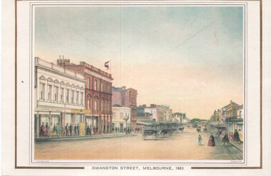 Melbourne Tram Museum
Artwork, other, Swanston Street Melbourne 1863
Colour print of a reproduction of an oil painting - Swanston Street from a point north of Little Bourke St looking south towards the Kings Domain. Reproduced by Kew Cottages and St Nicholas Parent's Association from a original print and lithographed by F Cogne, printed and published by Charles Troedel in his Melbourne Album 1863. Appears to have a number of horse drawn cabs parked in the centre of the street.Yields information about early Melbourne after the start of the gold rush.Reproduction of an oil painting - card - Swanston Street Melbourne 1863melbourne, horse drawn vehicles, swanston st -
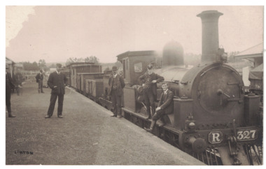 Linton and District Historical Society Inc
Postcard - Photograph, Steam Train, Linton Railway Station
Postcard which has a black and white image of a steam engine and carriages at Linton Railway Station. The R class engine was constructed at the Phoenix Foundry, Ballarat, between 1881 and 1886.Text, reverse: "Boy sitting on engine is Harold Morgan, man wearing bowler hat standing beside engine thought to be Mr Bourke, engine driver, father of Kitty and Lizzie. White house behind station master's cap, weatherboard cottage occupied by Mrs Howe, her daughter Myra and son Billy. Man on station wearing cap thought to be station master, Alec Thompson's father".linton railway station, steam engines, transport, railways -
 Eltham District Historical Society Inc
Document, Declaration of Trust as to The Eltham Hall, Lot 20 Henry Street, Eltham, 5 Aug 1922
William James Capewell, Ernest James Andrew and George Harrison all of Eltham collected the sum of £150 towards the purchase of Lot 20 Henry Street and whereby a Contract of Sale dated 30 December 1921 agreed to purchase (as Trustees of The Eltham Hall to be used in perpetuity for the benefit of the inhabitants of the Eltham District) the land, furniture, fittings and chattels from Jack Alfred Harrison, George Hugh Bird and Edward Samuel McColl for £750. The first President was declared to be Ernest James Andrew, Honorary Secretary, A.J. Morse, Honorary Treasurer, Charles Robert Nicholls and the first elective committee to be Thomas Nunn Jewell, William John Pasco, George Burchall, William James Burgess, John William Cox, Ernest James Andrew, John Michael Ryan, Frederick William Gillespie Didfield, Charles Harold Williams, Joseph Banks, Laurence Bourke, Charles Robert Nicholls, William James Capewell and James Pascal. This committee was appointed until the Annual meeting of subscribers held in January 1923 at which point all could stand for re-election (held annually). The Trust Deed was signed by Ernest James Andrew, William James Capewell and George Harrison in the presence of John Michael Ryan, Builder of Eltham, 5 August 1922. Originally purchased in 1856 from Thomas Roberts, Yeoman of Little Eltham, for £10 for use by the Wesleyan Chapel, represented by indentured Trustees, Rev. Barnabas Shaw Walker, Minister of the Pentridge Circuit, Francis Thomas, Farmer of Keelbundora, William Harriman, Blacksmith of Nillumbik, Nicholas Rodda, Farmer of Nillumbik, Aaron Grimshaw, Farmer of Greensborough, Joseph Cooper, Gardener of Keelbundora, Peter Dredge, Scholmaster of Jika Jika and Samuel Jeffrey, Farmer of Jika Jika. Lot 20 of Subdivision of Portion 13, Section 4 of the Parish of Nillumbik in the County of Evelyn was located on the southern side of Henry street in Little Eltham North, where the current Our Lady Help of Christians Catholic Church is situated. It became the location of the Eltham Rechabite Hall. In 1893 a new hall was built and further enlarged in 1919. At the commencement of 1922, the property was purchased from the Independent Order of Rechabites with publicly subscribed funds and a new hall built at a cost of £750 and improved road access constructed to reduce the grade, running from Dudley Street to Henry Street. This hall was eventually replaced with the new Shire Offices and Hall built on the corner of Arthur Street and Main Road, which was opened in 1941. Traces the earliest history of the Eltham Public Hall in Henry Street and the various names, occupations and abodes of the Trustees associated with the propertya.j. morse, charles harold williams, charles robert nicholls, edward samuel mccoll, eltham public hall, eltham rechabite hall, eltham wesleyan chapel, ernest james andrew, frederick william gillespie didfield, george burchall, george harrison, george hugh bird, henry street, jack alfred harrison, james pascal, john michael ryan, john william cox, joseph banks, laurence bourke, thomas nunn jewell, trustee, william james burgess, william james capewell, william john pasco -
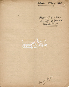 Eltham District Historical Society Inc
Document, Appointment of new Trustee for Eltham Public Hall, Lot 20 Henry Street, Eltham, 6 Aug 1925
Indenture made 6 August 1925 between Ernest James Andrew, News Agent, Cyril Robert Nicholls, Grocer, John Michael Ryan, Builder, Ellen Matilda Andrew, Married Woman, Alice Maude Bourke, Spinster, Mary Ellen Birchall, Married Woman, Adeline Gertrude Phillips, Married Woman, Minnie Maria Isherwood, Married Woman, Florence Garner, Spinster, Ethel Boake, Married Woman, Edith Marion Bowman, Married Woman, Clarice Armstrong, Spinster, Annie Ryan, Married Woman, William Pasco, Gentleman, Thomas Bowman, Printer, Arthur Copeland Christopherson, Grocer, Thomas Nunan Jewell, Carpenter all of Eltham (the Committee of The Eltham Hall) and William James Capewell, Butcher and Ernest James Andrew both of Eltham and Trustees for The Eltham Hall and George Birchall, Hatter of Eltham to be appointed a Trustee in lieu of George Harrison who requested to be discharged as a Trustee. Originally purchased in 1856 from Thomas Roberts, Yeoman of Little Eltham, for £10 for use by the Wesleyan Chapel, represented by indentured Trustees, Rev. Barnabas Shaw Walker, Minister of the Pentridge Circuit, Francis Thomas, Farmer of Keelbundora, William Harriman, Blacksmith of Nillumbik, Nicholas Rodda, Farmer of Nillumbik, Aaron Grimshaw, Farmer of Greensborough, Joseph Cooper, Gardener of Keelbundora, Peter Dredge, Scholmaster of Jika Jika and Samuel Jeffrey, Farmer of Jika Jika. Lot 20 of Subdivision of Portion 13, Section 4 of the Parish of Nillumbik in the County of Evelyn was located on the southern side of Henry street in Little Eltham North, where the current Our Lady Help of Christians Catholic Church is situated. It became the location of the Eltham Rechabite Hall. In 1893 a new hall was built and further enlarged in 1919. At the commencement of 1922, the property was purchased from the Independent Order of Rechabites with publicly subscribed funds and a new hall built at a cost of £750 and improved road access constructed to reduce the grade, running from Dudley Street to Henry Street. This hall was eventually replaced with the new Shire Offices and Hall built on the corner of Arthur Street and Main Road, which was opened in 1941. Traces the earliest history of the Eltham Public Hall in Henry Street and the various names, occupations and abodes of the Trustees associated with the propertyadeline gertrude phillips, alice maude bourke, annie ryan, arthur copeland christopherson, clarice armstrong, cyril robert nicholls, edith marion bowman, ellen matilda andrew, eltham public hall, eltham rechabite hall, eltham wesleyan chapel, ernest james andrew, ethel boake, florence garner, george birchall, george harrison, grocer, henry street, john michael ryan, mary ellen birchall, minnie maria isherwood, thomas bowman, thomas nunan jewell, trustee, william james capewell, william pasco